生物多样性 ›› 2025, Vol. 33 ›› Issue (10): 25165.  DOI: 10.17520/biods.2025165  cstr: 32101.14.biods.2025165

• 数据论文 • 上一篇    下一篇

四川省甘洛县马鞍山省级自然保护区及周边地区红外相机鸟兽监测数据集

李菡1,#(), 董伟2,#, 陆江涛1(), 吴永杰1(), 何兴成1(), 刘林2, 木留里哈2, 张学林2,*()   

  1. 1.四川大学生命科学学院, 生物资源与生态环境教育部重点实验室, 四川省濒危动物保护生物学重点实验室, 成都 610065
    2.四川省甘洛县马鞍山省级自然保护区保护中心, 四川甘洛 616850
  • 收稿日期:2025-05-04 接受日期:2025-10-09 出版日期:2025-10-20 发布日期:2025-11-17
  • 通讯作者: * E-mail: 2658256518@qq.com
  • 作者简介:# 共同第一作者
  • 基金资助:
    四川马鞍山省级自然保护区红外相机监测项目和国家自然科学基金(32470533)

A camera-trapping dataset of avian and mammalian diversity in Ma’anshan Provincial Nature Reserve and surrounding areas, Ganluo County, Sichuan Province

Han Li1,#(), Wei Dong2,#, Jiangtao Lu1(), Yongjie Wu1(), Xingcheng He1(), Lin Liu2, Liha Muliu2, Xuelin Zhang2,*()   

  1. 1 Key Laboratory of Bio-Resource and Eco-Environment of Ministry of Education, College of Life Sciences, Sichuan Key Laboratory of Conservation Biology on Endangered Wildlife, Sichuan University, Chengdu 610065, China
    2 Conservation Center of Ma’anshan Provincial Nature Reserve, Ganluo, Sichuan 616850, China
  • Received:2025-05-04 Accepted:2025-10-09 Online:2025-10-20 Published:2025-11-17
  • Contact: * E-mail: 2658256518@qq.com
  • About author:# Co-first authors
  • Supported by:
    Sichuan Ma’anshan Nature Reserve Infrared Camera Monitoring Project and National Natural Science Foundation of China(32470533)

摘要:

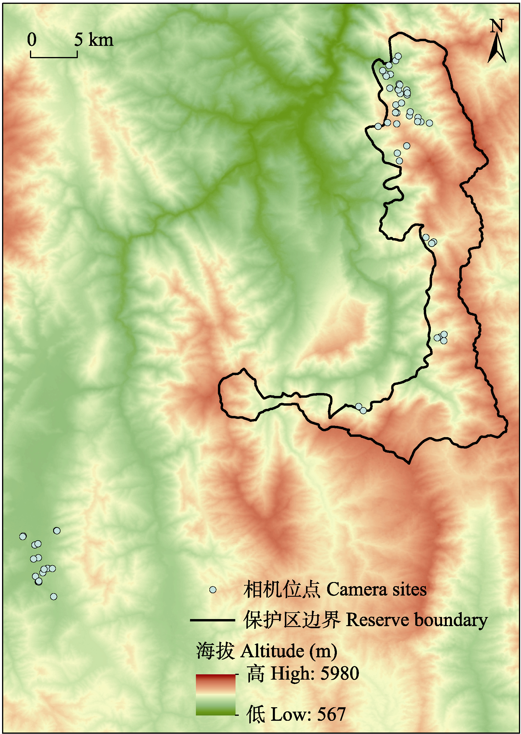
野生动物多样性监测是生物多样性保护的重要手段和自然保护区的重要工作内容。四川省甘洛县马鞍山省级自然保护区位于四川盆地西缘向青藏高原过渡的高山峡谷地带, 是大熊猫(Ailuropoda melanoleuca)最南部边缘种群的重要分布区。本研究整理了该地区2021-2024年间共1,136.08 GB的红外相机监测数据, 经过筛查和物种鉴定后, 获得了完整的红外相机鸟兽监测数据集。该数据集覆盖有效调查点位59个, 累积17,586个相机工作日, 共拍摄了38,482条影像数据。其中, 兽类记录12,325条, 独立有效探测次数5,911次, 涵盖了4目14科24种; 鸟类记录5,427条, 独立有效探测次数1,578次, 涉及5目21科51种。本数据集对马鞍山省级自然保护区鸟兽物种进行了编目, 并提供了时空分布信息, 为了解该保护区生物多样性现状和后续保护管理与深入研究提供了重要基础数据。

数据库(集)基本信息简介

数据库(集)名称 四川省甘洛县马鞍山省级自然保护区及周边地区红外相机鸟兽监测数据集
作者 李菡, 董伟, 陆江涛, 吴永杰, 何兴成, 刘林, 木留里哈, 张学林
通讯作者 张学林(2658256518@qq.com)
时间范围 2021-2024年
地理区域 四川马鞍山省级自然保护区, 地理范围: 28°31'-29°01' N, 102°30'-102°54' E, 面积27,981 ha; 相机布设位点海拔跨度1,530-3,040 m
文件大小 4.3 MB
数据格式 *.xlsx, *.pdf
数据链接 https://doi.org/10.57760/sciencedb.24008
https://www.biodiversity-science.net/fileup/1005-0094/DATA/2025165.zip
数据库(集)组成 数据集共包括4份数据文件和1份代表性物种照片。其中数据文件内包含: (1)相机位点及相机工作日; (2)相机记录条数; (3)物种独立有效探测次数; (4)鸟兽物种名录; (5)相机位点信息; (6)初始物种信息表。

关键词: 马鞍山省级自然保护区, 红外相机, 多样性监测, 鸟类, 兽类, 名录

Abstract

Wildlife diversity monitoring is a crucial approach for biodiversity conservation and an essential task within nature reserves. The Ma’anshan Provincial Nature Reserve in Ganluo County, Sichuan Province, is located in a mountainous canyon area transitioning from the western edge of the Sichuan Basin to the Qinghai-Xizang Plateau. It serves as an important distribution area for the southernmost marginal population of the giant panda (Ailuropoda melanoleuca). This study compiled a total of 1,136.08 GB of infrared camera monitoring data collected from 2021 to 2024 in the region. After screening and species identification, a comprehensive dataset of bird and mammal observations from infrared cameras was provided. The dataset covers 59 effective camera sites, accumulating 17,586 camera days and capturing 38,482 video records. Among these, there were 12,325 mammal records, with 5,911 independent valid detections, covering 24 mammal species across 4 orders and 14 families. Additionally, 5,427 bird records were documented, with 1,578 independent valid detections, involving 51 bird species across 5 orders and 21 families. This dataset provides a checklist of the bird and mammal species and spatiotemporal distribution information, offering fundamental data for understanding the current state of biodiversity in the reserve and supporting subsequent conservation management as well as further research.

Database/Dataset Profile

Title A camera-trapping dataset of avian and mammalian diversity in Ma’anshan Provincial Nature Reserve and surrounding areas, Ganluo County, Sichuan Province
Data author(s) Han Li, Wei Dong, Jiangtao Lu, Yongjie Wu, Xingcheng He, Lin Liu, Liha Muliu, Xuelin Zhang
Data corresponding author Xuelin Zhang (2658256518@qq.com)
Time range 2021-2024
Geographical scope The Ma’anshan Provincial Nature Reserve in Sichuan spans a geographical range of 28°31'-29°01' N, 102°30'-102°54' E, covering an area of 27,981 ha. The elevation of the camera trap deployment sites: 1,530-3,040 m
File size 4.3 MB
Data format *.xlsx, *.pdf
Data Link https://doi.org/10.57760/sciencedb.24008
https://www.biodiversity-science.net/fileup/1005-0094/DATA/2025165.zip
Database/Dataset composition The dataset consists of 4 data files and 1 compressed photo of representative species. The data file contains: (1) Camera location and camera working days; (2) Number of camera records; (3) Number of independent effective detections of species; (4) List of animal and bird species; (5) Camera location information; (6) Initial species information table.

Key words: Ma’anshan Provincial Nature Reserve, infrared camera, diversity monitoring, bird, mammal, checklist