
生物多样性 ›› 2018, Vol. 26 ›› Issue (9): 951-961. DOI: 10.17520/biods.2018012 cstr: 32101.14.biods.2018012
丁晨晨1,2#, 胡一鸣1,2#, 李春旺1,2, 蒋志刚1,2,*( )
)
收稿日期:2018-01-11
接受日期:2018-05-26
出版日期:2018-09-20
发布日期:2019-01-05
通讯作者:
蒋志刚
作者简介:# 共同第一作者
基金资助:
Chenchen Ding1,2#, Yiming Hu1,2#, Chunwang Li1,2, Zhigang Jiang1,2,*()
Received:2018-01-11
Accepted:2018-05-26
Online:2018-09-20
Published:2019-01-05
Contact:
Jiang Zhigang
About author:# Co-first authors
摘要:
印度野牛(Bos gaurus)在中国分布在云南省南部和西藏藏南地区。2016年2-3月和2016年11-12月, 我们在西双版纳州、普洱市及高黎贡山区域开展印度野牛调查, 并对藏南地区进行文献调研, 共获得47处印度野牛有效出现位点数据。目前云南地区印度野牛种群数量约180-210头, 面临着严重的生存危机; 在高黎贡山未发现印度野牛。利用印度野牛分布位点数据, 选取地形、土地覆被类型、人类足迹指数、距水源和道路距离以及气候共5类14种因子作为自变量建立MaxEnt生态位模型, 通过模拟云南和西藏印度野牛的适宜分布区, 分析各环境因子对该物种分布的影响。结果表明: 模型预测精度较高, 平均AUC (area under the curve)值为0.994。印度野牛潜在适宜栖息地可划分为高适宜、次适宜、低适宜和不适宜4个等级。高适宜栖息地主要分布在云南省西双版纳和藏南地区, 其中西双版纳部分镶嵌有次适宜和低适宜栖息地斑块, 面积为4,987 km²; 藏南部分高适宜栖息地面积为13,995 km²。次适宜栖息地主要分布于云南省南部、高黎贡山区域以及藏南高适宜栖息地区的边缘, 总面积为32,778 km²。低适宜和不适宜栖息地区连接成片, 位于云南省中部、北部地区和藏南地区北部。Jackknife检验结果显示, 季节温度变化和等温线对印度野牛潜在分布区的影响较大, 而地形因子和降水变化的影响较弱。遥感地物分类结果表明: 橡胶林等人工经济林的种植占据了西双版纳野牛的适宜栖息地, 降低了景观连接度。建议管理部门加大对天然林的保护力度, 控制橡胶林等人工林在野牛适宜栖息地的扩张, 提高景观连接度, 以促进该物种种群的恢复。
丁晨晨, 胡一鸣, 李春旺, 蒋志刚 (2018) 印度野牛在中国的分布及其栖息地适宜性分析. 生物多样性, 26, 951-961. DOI: 10.17520/biods.2018012.
Chenchen Ding, Yiming Hu, Chunwang Li, Zhigang Jiang (2018) Distribution and habitat suitability assessment of the gaur Bos gaurus in China. Biodiversity Science, 26, 951-961. DOI: 10.17520/biods.2018012.
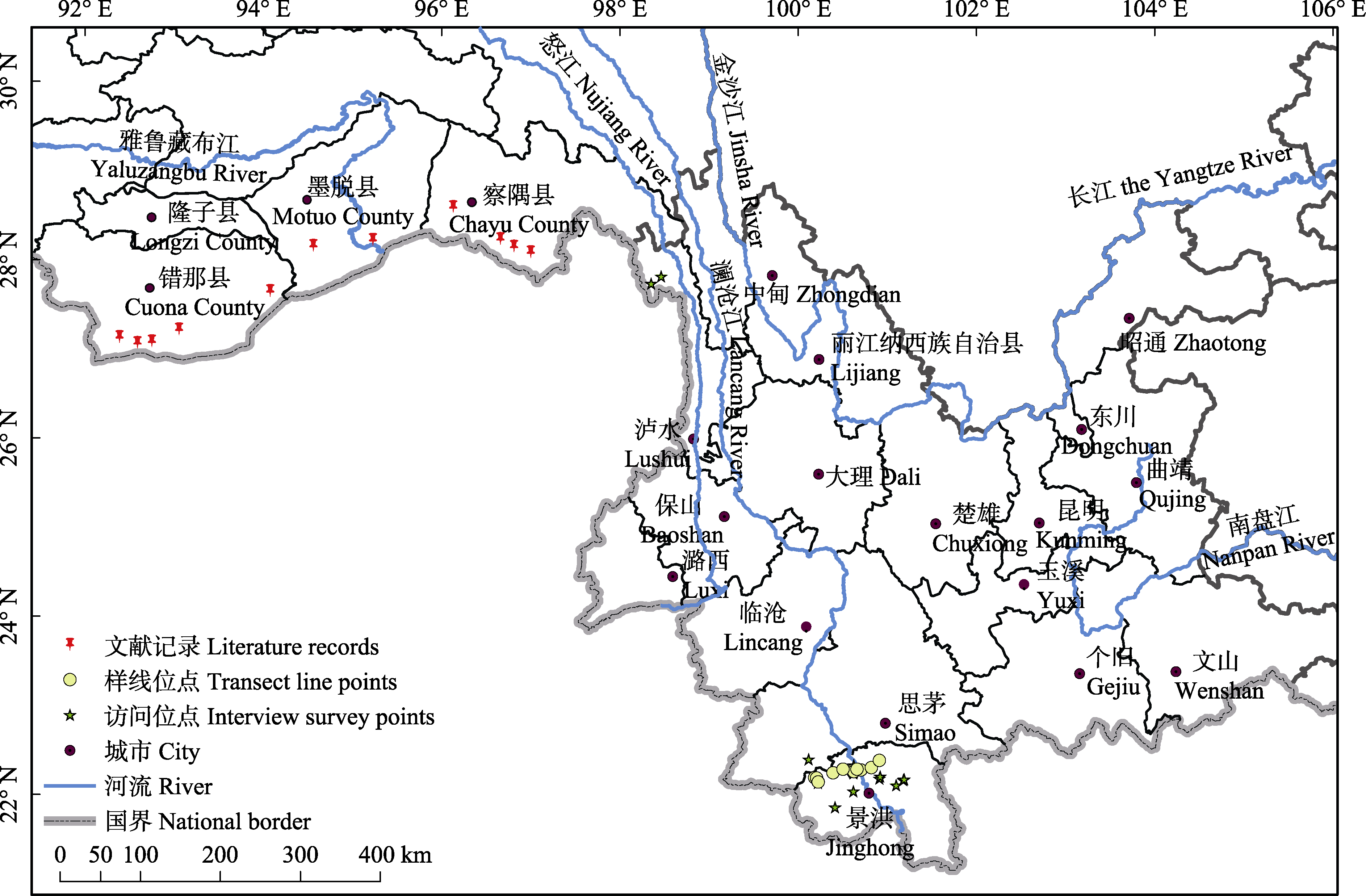
图1 中国印度野牛出现点分布图
Fig. 1 Occurrence points of gaur in China
| 编码 Code | 描述 Description | 来源 Source |
|---|---|---|
| BIO1 | 年均温 Annual mean temperature | WorldClim database Version 1.4 |
| BIO3 | 等温线 Isothermality | WorldClim database Version 1.4 |
| BIO4 | 季节温度变化 Temperature seasonality | WorldClim database Version 1.4 |
| BIO7 | 气温年较差 Temperature annual range | WorldClim database Version 1.4 |
| BIO9 | 最旱季均温 Mean temperature of driest quarter | WorldClim database Version 1.4 |
| BIO12 | 年均降水量 Annual precipitation | WorldClim database Version 1.4 |
| BIO15 | 降水季节性 Precipitation seasonality | WorldClim database Version 1.4 |
| BIO19 | 最冷季均温 Precipitation of coldest quarter | WorldClim database Version 1.4 |
| LCT | 土地覆被类型 Land cover type | Global Land Cover Facility |
| HFI | 人类足迹指数 Human footprint influence | Last of the Wild Data Version 2 |
| ALT | 海拔 Altitude | Chinese Natural Resources Database |
| Slop | 坡度 Slope | Chinese Natural Resources Database |
| Dis_road | 距主要道路距离 Distance to major roads | National Catalogue Service for Geographic Information |
| Dis_water | 距水源地距离 Distance to water source | National Catalogue Service for Geographic Information |
表1 模拟印度野牛适宜分布区时所用的环境变量
Table 1 Environmental variables used to model the potential distribution range of the gaur
| 编码 Code | 描述 Description | 来源 Source |
|---|---|---|
| BIO1 | 年均温 Annual mean temperature | WorldClim database Version 1.4 |
| BIO3 | 等温线 Isothermality | WorldClim database Version 1.4 |
| BIO4 | 季节温度变化 Temperature seasonality | WorldClim database Version 1.4 |
| BIO7 | 气温年较差 Temperature annual range | WorldClim database Version 1.4 |
| BIO9 | 最旱季均温 Mean temperature of driest quarter | WorldClim database Version 1.4 |
| BIO12 | 年均降水量 Annual precipitation | WorldClim database Version 1.4 |
| BIO15 | 降水季节性 Precipitation seasonality | WorldClim database Version 1.4 |
| BIO19 | 最冷季均温 Precipitation of coldest quarter | WorldClim database Version 1.4 |
| LCT | 土地覆被类型 Land cover type | Global Land Cover Facility |
| HFI | 人类足迹指数 Human footprint influence | Last of the Wild Data Version 2 |
| ALT | 海拔 Altitude | Chinese Natural Resources Database |
| Slop | 坡度 Slope | Chinese Natural Resources Database |
| Dis_road | 距主要道路距离 Distance to major roads | National Catalogue Service for Geographic Information |
| Dis_water | 距水源地距离 Distance to water source | National Catalogue Service for Geographic Information |
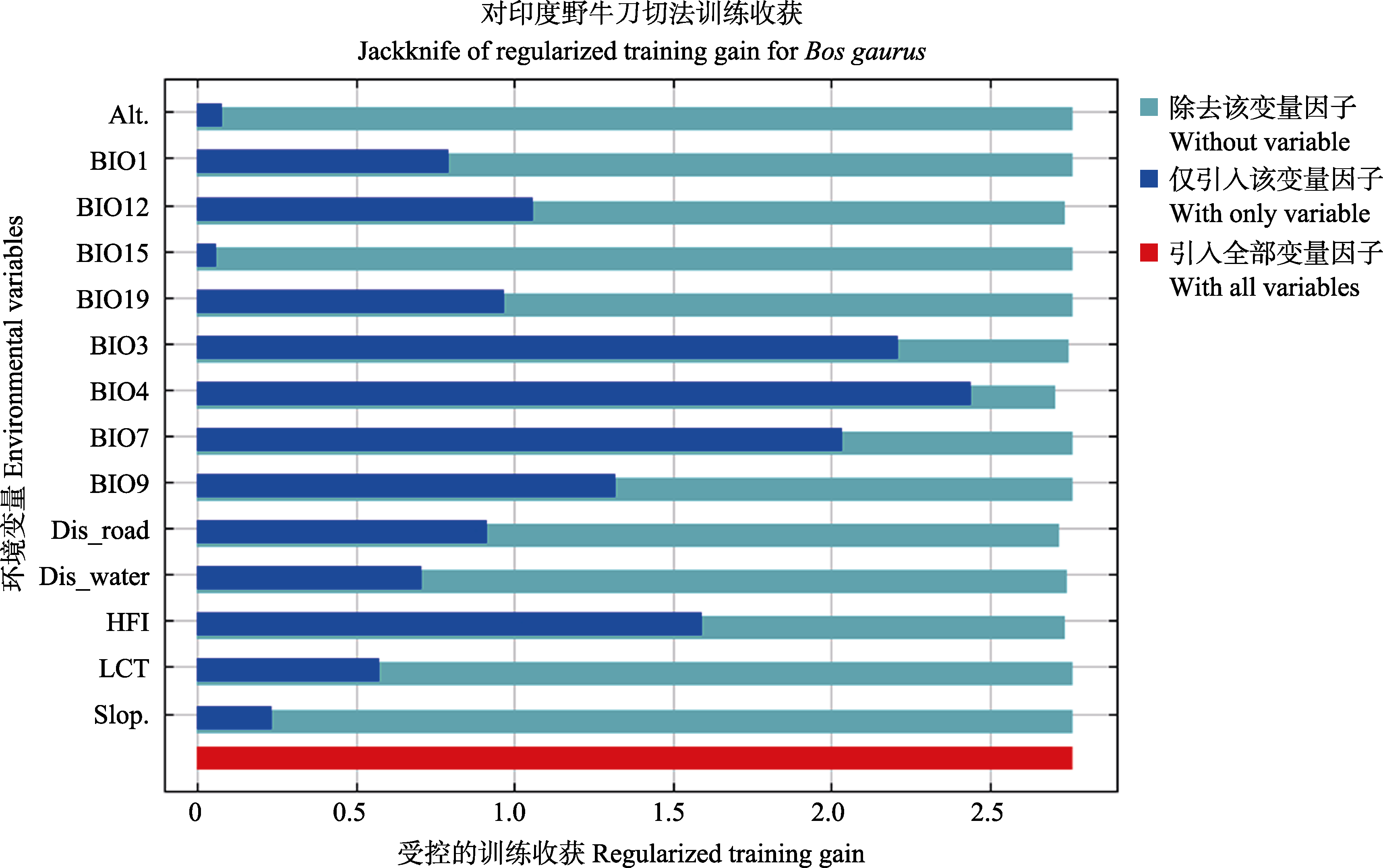
图2 环境因子对印度野牛分布作用的Jackknife刀切法评价
Fig.2 Jackknife evaluation of environmental variables in gaur distribution
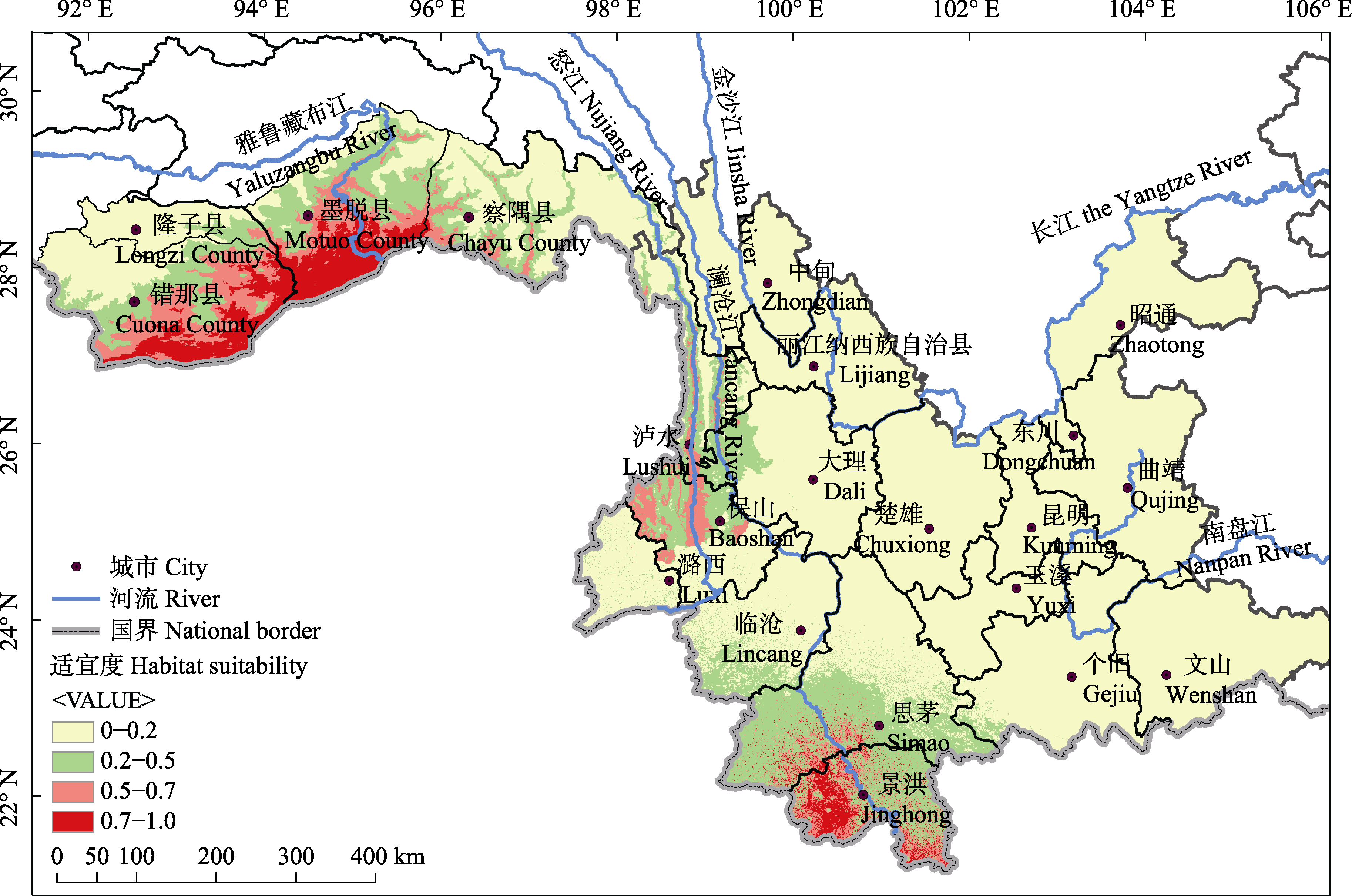
图3 中国印度野牛潜在适宜栖息地分布图
Fig. 3 Potential suitable habitats of gaur in China
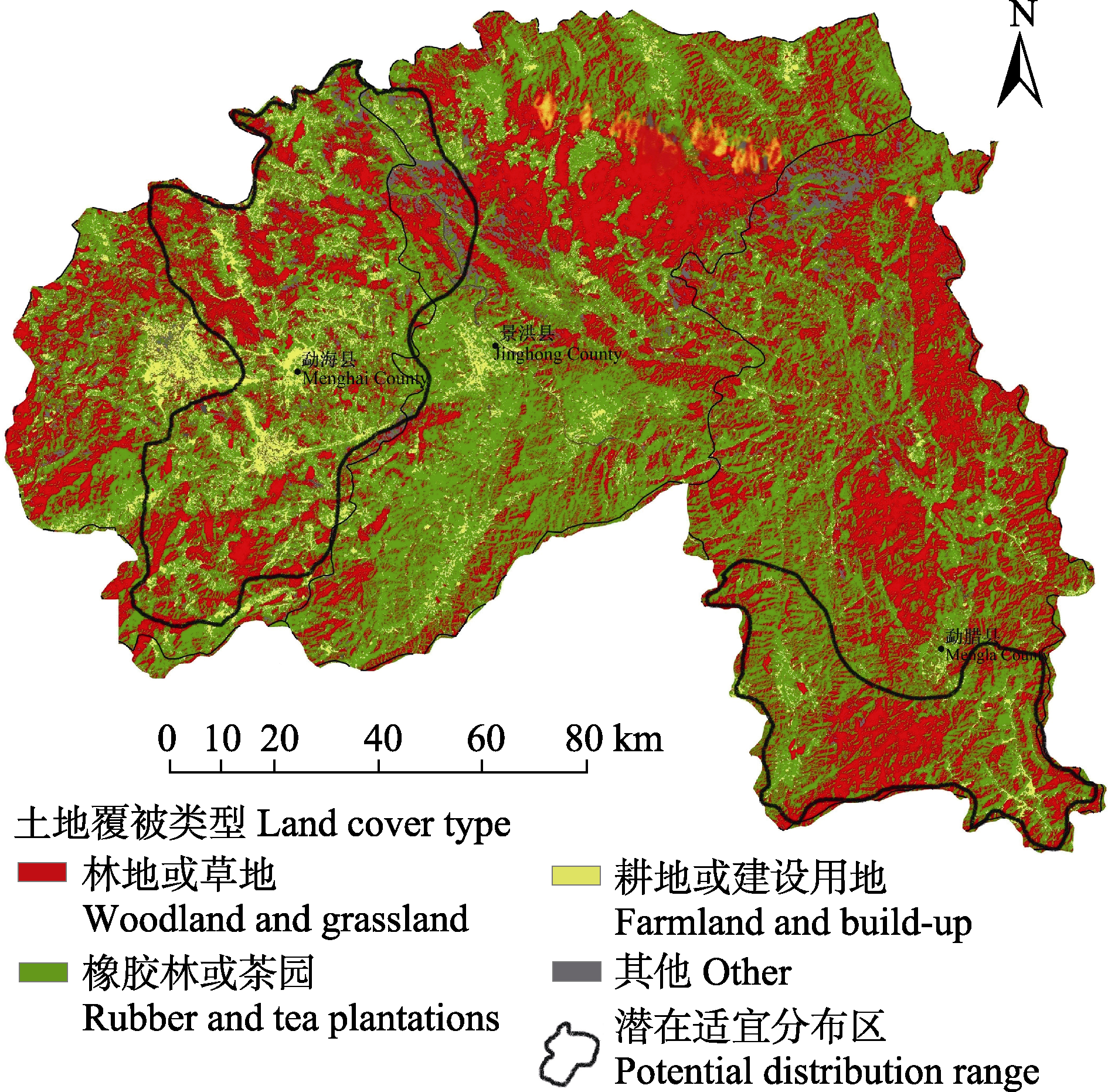
图4 2016年西双版纳土地覆被类型
Fig. 4 Land use in Xishuangbanna in 2016
| [1] | Araujo M, Pearson R, Thuiller WM (2005) Validation of species-climate impact models under climate change. Global Change Biology, 11, 1504-1513. |
| [2] | Ball GH, Hall DJ (1967) A clustering technique for summarizing multivariate data. Behavioral Science, 12, 153-155. |
| [3] | Catry FX, Rego FC, Bação F, Moreira F (2009) Modeling and mapping wildfire ignition risk in Portugal. International Journal of Wildland Fire, 18, 921-931. |
| [4] | Chen LD, Fu BJ (1996) The ecological significance and application of landscape connectivity. Chinese Journal of Ecology, 15, 37-42. (in Chinese with English abstract) |
| [陈利顶, 傅伯杰 (1996) 景观连接度的生态学意义及其应用. 生态学杂志, 15, 37-42.] | |
| [5] | China’s State Forestry Administration(2009) National Survey on Key Terrestrial Wildlife Resources in China. China Forestry Publishing House, Beijing. |
| [国家林业局(2009) 中国重点陆生野生动物资源调查. 中国林业出版社, 北京.] | |
| [6] | Choudhury A (2002) Distribution and conservation of the gaur Bos gaurus, in the Indian subcontinent. Mammal Review, 32, 199-226. |
| [7] | Conry PJ (1989) Gaur Bos gaurus, and development in Malaysia. Biological Conservation, 49, 47-65. |
| [8] | Costanza R, D’Arge R, Groot RD, Farber S, Grasso M, Hannon B, Limburg K, Naeem S, Neill R, Paruelo J, Raskin RG, Sutton P, Belt M (1997) The value of the world’s ecosystem services and natural capital. World Environment, 25, 3-15. |
| [9] | Duckworth JW, Sankar K, Williams AC, Samba KN, Timmins RJ (2016) Bos gaurus. The IUCN Red List of Threatened Species.2016) Bos gaurus. The IUCN Red List of Threatened Species. |
| [10] | Foley JA, Defries R, Asner GP, Barford C, Bonan G, Carpenter SR, Chapin FS, Coe MT, Daily GC, Gibbs HK, Helkowski JH, Holloway T, Howard EA, Kucharik CJ, Monfreda C, Patz JA, Prentice C, Ramankutty N, Snyder PK (2005) Global consequences of land use. Science, 309, 570-574. |
| [11] | Gan HX, Hu HB (2008) Biodiversity conservation corridor design based on habitat selection of gaur (Bos gaurus): A case study from Xishuangbanna, China. Chinese Journal of Ecology, 27, 2153-2158. (in Chinese with English abstract) |
| [甘宏协, 胡华斌 (2008) 基于野牛生境选择的生物多样性保护廊道设计: 来自西双版纳的案例. 生态学杂志, 27, 2153-2158.] | |
| [12] | Hall LS, Krausman PR, Morrison ML (1997) The habitat concept and a plea for standard terminology. Wildlife Society Bulletin, 25, 173-182. |
| [13] | Heinen JT, Sompoad S (1996) Status and protection of Asian wild cattle and buffalo. Conservation Biology, 10, 931-934. |
| [14] | Hirzel AH, Helfer V, Metral F (2001) Assessing habitat-suitability models with a virtual species. Ecological Modelling, 145, 111-121. |
| [15] | Jiang ZG, Jiang JP, Wang YZ, Zhang E, Zhang YY, Li LL, Xie F, Cai B, Cao L, Zheng GM, Dong L, Zhang ZW, Ding P, Luo ZH, Ding CQ, Ma ZJ, Tang SH, Cao WX, Li CW, Hu HJ, Ma Y, Wu Y, Wang YX, Zhou KY, Liu SY, Chen YY, Li JT, Feng ZJ, Wang Y, Wang B, Li C, Song XL, Cai L, Zang CX, Zeng Y, Meng ZB, Fang HX, Ping XG (2016) Red List of China’s Vertebrates. Biodiversity Science, 24, 500-551. (in Chinese and in English) |
| [蒋志刚, 江建平, 王跃招, 张鹗, 张雁云, 李立立, 谢锋, 蔡波, 曹亮, 郑光美, 董路, 张正旺, 丁平, 罗振华, 丁长青, 马志军, 汤宋华, 曹文宣, 李春旺, 胡慧建, 马勇, 吴毅, 王应祥, 周开亚, 刘少英, 陈跃英, 李家堂, 冯祚建, 王燕, 王斌, 李成, 宋雪琳, 蔡蕾, 臧春鑫, 曾岩, 孟智斌, 方红霞, 平晓鸽 (2016) 中国脊椎动物红色名录. 生物多样性, 24, 500-551.] | |
| [16] | Jiang ZG, Liu SY, Wu Y, Jiang XL, Zhou KY (2017) China’ mammalian diversity(2nd edition). Biodiversity Science, 25, 886-895. (in Chinese with English abstract) |
| [蒋志刚, 刘少英, 吴毅, 蒋学龙, 周开亚 (2017) 中国哺乳动物多样性(第2版). 生物多样性, 25, 886-895.] | |
| [17] | Leshowitz B (1969) Comparison of ROC curves from one- and two- interval rating-scale procedures. Journal of the Acoustical Society of America, 46, 399-402. |
| [18] | Li H, Aide TM, Ma Y, Liu W, Cao M (2007) Demand for rubber is causing the loss of high diversity rain forest in SW China. Biodiversity & Conservation, 16, 1731-1745. |
| [19] | Li MY, Ju YW, Kumar S, Stohlgren TJ (2009) Modeling of potential habitat for endangered wild animals: A case study of gaur Bos gaurus. Journal of Northeast Forestry University, 37, 88-91. (in Chinese with English abstract) |
| [李明阳, 巨云为, Kumar S, Stohlgren TJ (2009) 濒危野生动物潜在生境空间建模方法——以印度野牛(Bos gaurus)为例. 东北林业大学学报, 37, 88-91.] | |
| [20] | Liao CH, Li P, Feng ZM, Zhang JH (2014) Area monitoring by remote sensing and spatiotemporal variation of rubber plantations in Xishuangbanna. Transactions of the Chinese Society of Agricultural Engineering, 30, 170-180. (in Chinese with English abstract) |
| [廖谌婳, 李鹏, 封志明, 张景华 (2014) 西双版纳橡胶林面积遥感监测和时空变化. 农业工程学报, 30, 170-180.] | |
| [21] | Lian ZM, Yu GZ (2000) Edge effect and biodiversity. Chinese Biodiversity, 8, 120-125. (in Chinese with English abstract) |
| [廉振民, 于广志 (2000) 边缘效应与生物多样性. 生物多样性, 8, 120-125.] | |
| [22] | Liu XN, Feng ZM, Jiang LG, Zhang JH (2012) Rubber plantations in Xishuangbanna: Remote sensing identification and digital mapping. Resources Science, 34, 1769-1780. (in Chinese with English abstract) |
| [刘晓娜, 封志明, 姜鲁光, 张景华 (2012) 西双版纳橡胶林地的遥感识别与数字制图. 资源科学, 34, 1769-1780.] | |
| [23] | Margules CR, Pressey RL (2000) Systematic conservation planning. Nature, 405, 243-253. |
| [24] | Mishra C, Madhusudan MD, Datta A (2006) Mammals of the high altitudes of western “Arunachal Pradesh”, eastern Himalaya: An assessment of threats and conservation needs. Oryx, 40, 1-7. |
| [25] | Myers N, Mittermeier RA, Mittermeier CG, Da FG, Kent J (2000) Biodiversity hotspots for conservation priorities. Nature, 403, 853-858. |
| [26] | Pan QH, Wang YX, Yan K (2007) A Field Guide to the Mammals of China. China Forestry Publishing House, Beijing. (in Chinese) |
| [潘清华, 王应祥, 岩崑 (2007) 中国哺乳动物彩色图鉴. 中国林业出版社, 北京.] | |
| [27] | Pearson RG, Dawson TP (2003) Predicting the impacts of climate change on the distribution of species: Are bioclimate envelope models useful? Global Ecology & Biogeography, 12, 361-371. |
| [28] | Phillips SJ, Anderson RP, Schapire RE (2006) Maximum entropy modeling of species geographic distributions. Ecological Modelling, 190, 231-259. |
| [29] | Shou ZH, Cai XT (1958) New record for gaur in Xishuangbanna, Yunnan. Science Bulletin, 3, 112-113. (in Chinese) |
| [寿振黄, 蔡希陶 (1958) 云南西双版纳发现的野牛. 科学通报, 3, 112-113.] | |
| [30] | Smith AT, Xie Y (2009) A Guide to the Mammals of China. Hunan Education Press, Changsha. (in Chinese) |
| [Smith AT, 解焱 (2009) 中国兽类野外手册. 湖南教育出版社, 长沙.] | |
| [31] | Sreekar R, Huang G, Yasuda M, Quan RC, Goodale E, Richard T, Corlett RT, Tomlinson KW (2016) Effects of forests, roads and mistletoe on bird diversity in monoculture rubber plantations. Scientific Reports, 6, 21822. |
| [32] | Swets JA (1988) Measuring the accuracy of diagnostic systems. Science, 240, 1285-1293. |
| [33] | Wang YS, Xie BY, Wan FH, Xiao QM, Dai LY (2007) Application of ROC curve analysis in evaluating the performance of alien species’ potential distribution models. Biodiversity Science, 15, 365-372. (in Chinese with English abstract) |
| [王运生, 谢丙炎, 万方浩, 肖启明, 戴良英 (2007) ROC曲线分析在评价入侵物种分布模型中的应用. 生物多样性, 15, 365-372.] | |
| [34] | Yang DH, Zhang JY (1988) Population and distribution of Bos gaurus in Yunnan. Chinese Journal of Zoology, 23(1), 39-41. (in Chinese) |
| [杨德华, 张家银 (1988) 云南野牛的数量分布. 动物学杂志, 23(1), 39-41.] | |
| [35] | Yin F, Ma K, Liu DZ (2015) Population status, ecological habitat and threatened factors of wild gaur (Bos gaurus): A review. Journal of Beijing Normal University (Natural Science), 51, 504-510. (in Chinese with English abstract) |
| [尹峰, 马凯, 刘定震 (2015) 野牛的种群现状、生态习性及致危因素. 北京师范大学学报(自然科学版), 51, 504-510.] | |
| [36] | Yunnan Institute of Forest Inventory and Planning(1989) The Nature Reserve in Yunnan. China Forestry Publishing House, Beijing. (in Chinese) |
| [云南省林业调查规划院(1989) 云南自然保护区. 中国林业出版社, 北京.] | |
| [37] | Zhang HL, Li ZX, Wang RC (2000) A study on Bos gaurus habitat using multivariate statistical techniques and GIS—Taking the Naban River Basin Biosphere Reserve in Xishuangbanna as an example. Tropical Geography, 20, 152-155. (in Chinese with English abstract) |
| [张洪亮, 李芝喜, 王人潮 (2000) 应用多元统计技术和GIS技术进行印度野牛生境定量分析——以西双版纳纳板河流域生物圈保护区为例. 热带地理, 20, 152-155.] | |
| [38] | Zhang HL, Wang RC (1999) GIS-based ecotope types and their relationship with survival of Bos gaurus. Chinese Journal of Applied Ecology, 10, 619-622. (in Chinese with English abstract) |
| [张洪亮, 王人潮 (1999) 基于GIS的生境类型及其与印度野牛生存关系的研究. 应用生态学报, 10, 619-622.] | |
| [39] | Zhang ZY, Yang HP, Luo AD (2016) Population, distribution and conservation status of gaur (Bos gaurus) in Xishuangbanna Prefecture. Forest Inventory and Planning, 41, 115-119. (in Chinese with English abstract) |
| [张忠员, 杨鸿培, 罗爱东 (2016) 西双版纳印度野牛种群数量、分布和保护现状. 林业调查规划, 41, 115-119.] | |
| [40] | Zhu ZH, Wu QA, Yang LP (2003) Present status and conservation strategy of wild animal and plant resources in Gaoligongshan National Nature Reserve. Forestry Science & Technology, 28, 63-65. (in Chinese with English abstract) |
| [朱振华, 毋其爱, 杨礼攀 (2003) 高黎贡山自然保护区野生动植物资源现状及保护. 林业科技, 28, 63-65.] |
| [1] | 乔慧捷. 物种分布模型在宏观生态学和生物地理学中应用的思考[J]. 生物多样性, 2026, 34(1): 25238-. |
| [2] | 徐进博, 崔雅倩, 王渊, 王伟波, 刘锋, 王广龙, 扈晶晶, 普布顿珠, 边巴多吉, 旦增, 胡开, 王小川, 宋刚, 吕永磊, 温知新. 西藏雅鲁藏布大峡谷国家级自然保护区内白颊猕猴的栖息地适宜性评价[J]. 生物多样性, 2025, 33(7): 24493-. |
| [3] | 陈雯妍, 慈秀芹, 陈筠灵, 刘志芳, 李朗, 李捷. 云南樟科植物的多维多样性格局及其环境驱动因子[J]. 生物多样性, 2025, 33(6): 24558-. |
| [4] | 卢宸祺, 王剀, 于中斌, 吴云鹤, 郭宪光, 郭鹏, 车静. 中国青藏高原两栖、爬行动物多样性及其分布格局[J]. 生物多样性, 2025, 33(12): 25087-. |
| [5] | 陶斯琦, 杨飞龄, 华朝朗, 武瑞东. 通过综合受威胁状态和保护价值评估云南省自然植被的保护优先性[J]. 生物多样性, 2024, 32(3): 23324-. |
| [6] | 刘志发, 王新财, 龚粤宁, 陈道剑, 张强. 基于红外相机监测的广东南岭国家级自然保护区鸟兽多样性及其垂直分布特征[J]. 生物多样性, 2023, 31(8): 22689-. |
| [7] | 朱华. 地质事件和季风气候影响了云南植物区系和植被的演化[J]. 生物多样性, 2023, 31(12): 23262-. |
| [8] | 杨润明, 中村彰宏. 巢居蚂蚁更倾向于在人造光源附近定居繁殖[J]. 生物多样性, 2022, 30(8): 22067-. |
| [9] | 袁智勇, 陈进民, 吴云鹤, 李先琦, 车静. 云南省两栖类物种名录修订[J]. 生物多样性, 2022, 30(4): 21470-. |
| [10] | 戴静, 陈威兆, 金露露, 黄亮. 云南宜良上新世栎属植物研究及其古环境指示意义[J]. 生物多样性, 2022, 30(11): 22553-. |
| [11] | 杨久成, 刘佳, 李雨, 苏涛, 李树峰, 贾林波, 周浙昆, 张世涛. 滇东南普阳盆地含煤地层孢粉组合特征及其年代[J]. 生物多样性, 2022, 30(11): 21504-. |
| [12] | 邵桦, 杨京彪, 薛达元. 佤族传统文化在生物多样性保护中的作用[J]. 生物多样性, 2021, 29(8): 1120-1127. |
| [13] | 刘春晖, 杨京彪, 尹仑. 云南省生物多样性保护进展、成效与前瞻[J]. 生物多样性, 2021, 29(2): 200-211. |
| [14] | 王然, 乔慧捷. 生态位模型在流行病学中的应用[J]. 生物多样性, 2020, 28(5): 579-586. |
| [15] | 范靖宇, 李汉芃, 杨琢, 朱耿平. 基于本土最优模型模拟入侵物种水盾草在中国的潜在分布[J]. 生物多样性, 2019, 27(2): 140-148. |
| 阅读次数 | ||||||
|
全文 |
|
|||||
|
摘要 |
|
|||||
备案号:京ICP备16067583号-7
Copyright © 2026 版权所有 《生物多样性》编辑部
地址: 北京香山南辛村20号, 邮编:100093
电话: 010-62836137, 62836665 E-mail: biodiversity@ibcas.ac.cn
![]()