
生物多样性 ›› 2018, Vol. 26 ›› Issue (8): 878-891. DOI: 10.17520/biods.2018051 cstr: 32101.14.biods.2018051
周中一1, 刘冉1, 时书纳1, 苏艳军2, 李文楷1,*( ), 郭庆华2,3
收稿日期:2018-02-10
接受日期:2018-04-28
出版日期:2018-08-20
发布日期:2018-09-27
通讯作者:
李文楷
作者简介:# 共同第一作者
基金资助:
Zhongyi Zhou1, Ran Liu1, Shuna Shi1, Yanjun Su2, Wenkai Li1,*(), Qinghua Guo2,3
Received:2018-02-10
Accepted:2018-04-28
Online:2018-08-20
Published:2018-09-27
Contact:
Li Wenkai
About author:# Co-first authors
摘要:
生态位模型通过拟合物种分布与环境变量之间的关系提供物种空间分布预测, 在生物多样性研究中有广泛应用。激光雷达(LiDAR)是一种新兴的主动遥感技术, 已被大量应用于森林三维结构信息的提取, 但其在物种分布模拟的应用研究比较缺乏。本研究以美国加州内华达山脉南部地区的食鱼貂(Martes pennanti)的分布模拟为例, 探索LiDAR技术在物种分布模拟中的有效性。生态位模型采用5种传统多类分类器, 包括神经网络、广义线性模型、广义可加模型、最大熵模型和多元自适应回归样条模型, 并使用正样本-背景学习(presence and background learning, PBL)算法进行模型校正; 同时对这5种模型使用加权平均进行模型集成, 作为第6个模型。此外, 一类最大熵模型也被用于模拟该物种的空间分布。模型的连续输出和二值输出分别使用AUC (area under the receiver operating characteristic curve)以及基于正样本-背景数据的评价指标Fpb进行评价。结果表明, 仅考虑气候因子(温度和降水)时, 7个模型的AUC和Fpb平均值分别为0.779和1.077; 当考虑LiDAR变量(冠层容重、枝下高、叶面积指数、高程、坡度等)后, AUC和Fpb分别为0.800和1.106。该研究表明, LiDAR数据能够提高食鱼貂空间分布的预测精度, 在物种分布模拟方面存在一定的应用价值。
周中一, 刘冉, 时书纳, 苏艳军, 李文楷, 郭庆华 (2018) 基于激光雷达数据的物种分布模拟: 以美国加州内华达山脉南部区域食鱼貂分布模拟为例. 生物多样性, 26, 878-891. DOI: 10.17520/biods.2018051.
Zhongyi Zhou, Ran Liu, Shuna Shi, Yanjun Su, Wenkai Li, Qinghua Guo (2018) Ecological niche modeling with LiDAR data: A case study of modeling the distribution of fisher in the southern Sierra Nevada Mountains, California. Biodiversity Science, 26, 878-891. DOI: 10.17520/biods.2018051.
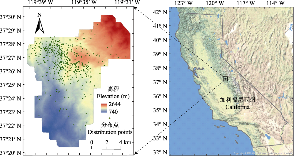
图1 研究区和食鱼貂位置分布图
Fig. 1 The study area and observed localities of fishers
| 变量代码 Variable code | 气候变量 Climate variables |
|---|---|
| Bio 1 | 1月降水量 Precipitation in January |
| Bio 2 | 4月降水量 Precipitation in April |
| Bio 3 | 7月降水量 Precipitation in July |
| Bio 4 | 10月降水量 Precipitation in October |
| Bio 5 | 1月平均温度 Mean temperature in January |
| Bio 6 | 4月平均温度 Mean temperature in April |
| Bio 7 | 7月平均温度 Mean temperature in July |
| Bio 8 | 10月平均温度 Mean temperature in October |
表1 预测食鱼貂潜在分布的8个气候变量
Table 1 8 climate variables for predicting the spatial distribution of fishers
| 变量代码 Variable code | 气候变量 Climate variables |
|---|---|
| Bio 1 | 1月降水量 Precipitation in January |
| Bio 2 | 4月降水量 Precipitation in April |
| Bio 3 | 7月降水量 Precipitation in July |
| Bio 4 | 10月降水量 Precipitation in October |
| Bio 5 | 1月平均温度 Mean temperature in January |
| Bio 6 | 4月平均温度 Mean temperature in April |
| Bio 7 | 7月平均温度 Mean temperature in July |
| Bio 8 | 10月平均温度 Mean temperature in October |
| 变量代码 Variable code | 激光雷达派生变量 LiDAR-derived variables |
|---|---|
| Bio 9 | 冠层容重 Canopy bulk density (CBD) |
| Bio 10 | 冠盖度 Canopy cover |
| Bio 11 | 树木胸径 Diameter at breast height (DBH) |
| Bio 12 | 枝下高 Height to live canopy base (HTLCB) |
| Bio 13 | 叶面积指数 Leaf area index (LAI) |
| Bio 14 | 最大树高 Maximum tree height |
| Bio 15 | 平均树高 Mean tree height |
| Bio 16 | 坡度 Slope |
| Bio 17 | 数字高程模型 Digital elevation model (DEM) |
表2 预测食鱼貂潜在分布的基于LiDAR的9个变量
Table 2 9 LiDAR-derived variables for predicting the spatial distribution of fishers
| 变量代码 Variable code | 激光雷达派生变量 LiDAR-derived variables |
|---|---|
| Bio 9 | 冠层容重 Canopy bulk density (CBD) |
| Bio 10 | 冠盖度 Canopy cover |
| Bio 11 | 树木胸径 Diameter at breast height (DBH) |
| Bio 12 | 枝下高 Height to live canopy base (HTLCB) |
| Bio 13 | 叶面积指数 Leaf area index (LAI) |
| Bio 14 | 最大树高 Maximum tree height |
| Bio 15 | 平均树高 Mean tree height |
| Bio 16 | 坡度 Slope |
| Bio 17 | 数字高程模型 Digital elevation model (DEM) |
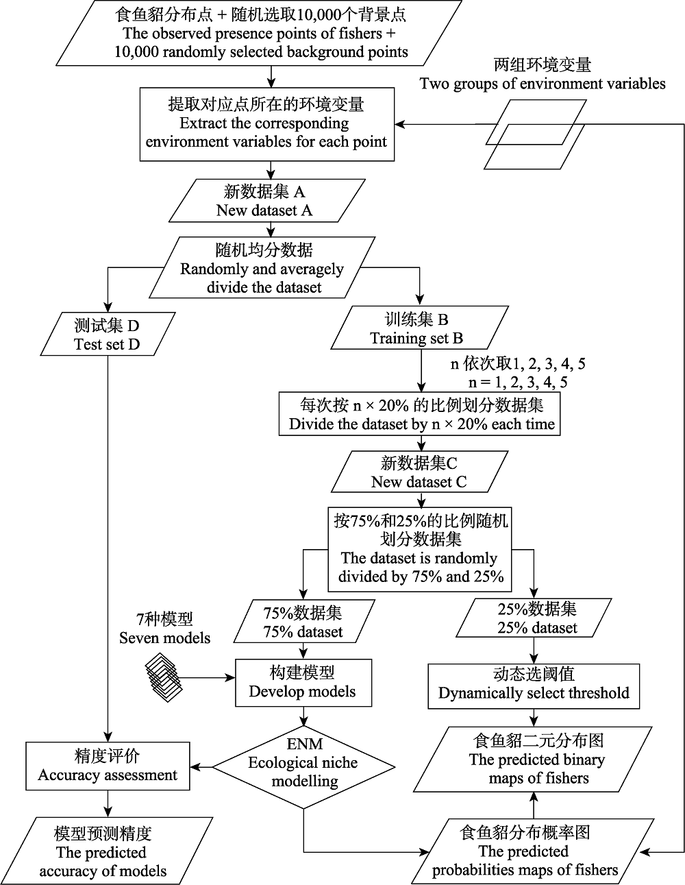
图2 模型构建和精度评价流程图
Fig. 2 Flow chart of model development and accuracy assessment
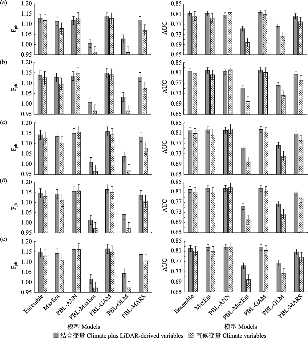
图3 不同模型基于不同环境变量的模型精度对比图。(a)训练样本量为20%; (b)训练样本量为40%; (c)训练样本量为60%; (d)训练样本量为80%; (e)训练样本量为100%。
Fig. 3 The accuracies of different models based on different environmental variables. (a) The training sample size is 20%; (b) The training sample size is 40%; (c) The training sample size is 60%; (d) The training sample size is 80%; (e) The training sample size is 100%.
| 模型类型 Types of models | 训练样本量 The training sample size | ||||
|---|---|---|---|---|---|
| 10% | 20% | 30% | 40% | 50% | |
| Ensemble | < 0.001 | < 0.001 | < 0.001 | < 0.001 | < 0.001 |
| MaxEnt | < 0.001 | < 0.001 | < 0.001 | < 0.001 | < 0.001 |
| PBL-ANN | < 0.001 | < 0.001 | < 0.001 | 0.001 | 0.030 |
| PBL-GAM | < 0.001 | < 0.001 | < 0.001 | < 0.001 | < 0.001 |
| PBL-GLM | < 0.001 | < 0.001 | < 0.001 | < 0.001 | < 0.001 |
| PBL-MARS | < 0.001 | < 0.001 | < 0.001 | < 0.001 | < 0.001 |
| PBL-MaxEnt | < 0.001 | < 0.001 | < 0.001 | < 0.001 | < 0.001 |
表3 基于不同环境变量的模型AUC显著性检验P值
Table 3 P-value of models’ AUC accuracy based on different environmental variables
| 模型类型 Types of models | 训练样本量 The training sample size | ||||
|---|---|---|---|---|---|
| 10% | 20% | 30% | 40% | 50% | |
| Ensemble | < 0.001 | < 0.001 | < 0.001 | < 0.001 | < 0.001 |
| MaxEnt | < 0.001 | < 0.001 | < 0.001 | < 0.001 | < 0.001 |
| PBL-ANN | < 0.001 | < 0.001 | < 0.001 | 0.001 | 0.030 |
| PBL-GAM | < 0.001 | < 0.001 | < 0.001 | < 0.001 | < 0.001 |
| PBL-GLM | < 0.001 | < 0.001 | < 0.001 | < 0.001 | < 0.001 |
| PBL-MARS | < 0.001 | < 0.001 | < 0.001 | < 0.001 | < 0.001 |
| PBL-MaxEnt | < 0.001 | < 0.001 | < 0.001 | < 0.001 | < 0.001 |
| 模型类型 Types of models | 训练样本量 The training sample size | ||||
|---|---|---|---|---|---|
| 10% | 20% | 30% | 40% | 50% | |
| Ensemble | 0.002 | 0.002 | < 0.001 | < 0.001 | < 0.001 |
| MaxEnt | < 0.001 | < 0.001 | < 0.001 | < 0.001 | < 0.001 |
| PBL-ANN | 0.001 | < 0.001 | 0.073 | 0.277 | 0.736 |
| PBL-GAM | 0.025 | 0.002 | < 0.001 | < 0.001 | < 0.001 |
| PBL-GLM | < 0.001 | < 0.001 | < 0.001 | < 0.001 | < 0.001 |
| PBL-MARS | < 0.001 | < 0.001 | < 0.001 | < 0.001 | < 0.001 |
| PBL-MaxEnt | < 0.001 | < 0.001 | < 0.001 | < 0.001 | < 0.001 |
表4 基于不同环境变量的模型Fpb显著性检验P值
Table 4 P-value of models’ Fpb accuracy based on different environmental variables
| 模型类型 Types of models | 训练样本量 The training sample size | ||||
|---|---|---|---|---|---|
| 10% | 20% | 30% | 40% | 50% | |
| Ensemble | 0.002 | 0.002 | < 0.001 | < 0.001 | < 0.001 |
| MaxEnt | < 0.001 | < 0.001 | < 0.001 | < 0.001 | < 0.001 |
| PBL-ANN | 0.001 | < 0.001 | 0.073 | 0.277 | 0.736 |
| PBL-GAM | 0.025 | 0.002 | < 0.001 | < 0.001 | < 0.001 |
| PBL-GLM | < 0.001 | < 0.001 | < 0.001 | < 0.001 | < 0.001 |
| PBL-MARS | < 0.001 | < 0.001 | < 0.001 | < 0.001 | < 0.001 |
| PBL-MaxEnt | < 0.001 | < 0.001 | < 0.001 | < 0.001 | < 0.001 |
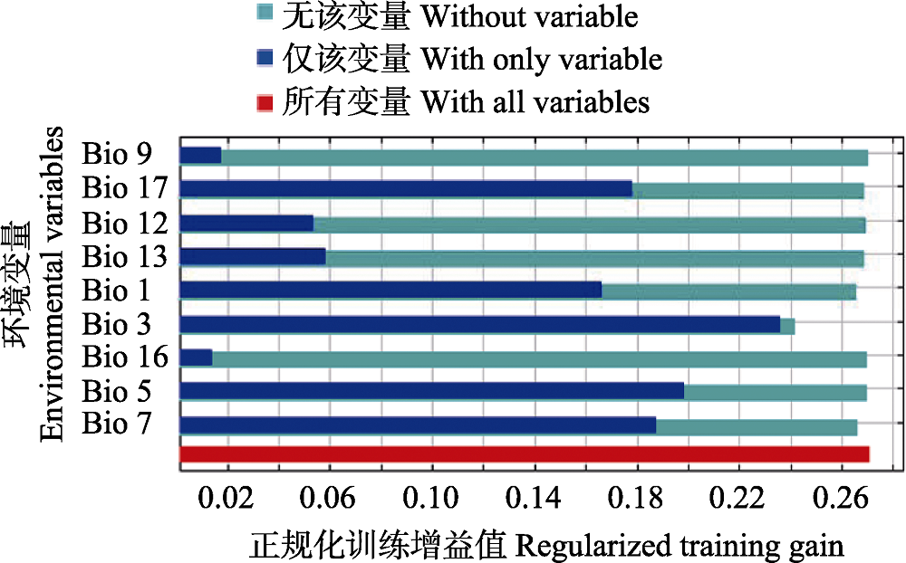
图4 基于Jackknife的环境变量重要性。变量的含义见表1和表2。
Fig. 4 The importance of environmental variables based on Jackknife analysis. The meanings of the variables are shown in Table 1 and Table 2.
图5 不同模型使用不同环境变量预测的食鱼貂概率分布图。(a)基于气候变量; (b)基于气候和LiDAR变量。
Fig. 5 The predicted probabilities maps of fishers by different models with different environmental variables. (a) Climate variables; (b) Climate plus LiDAR-derived variables.
图6 不同模型使用不同环境变量预测的食鱼貂二值分布图。(a)基于气候变量; (b)基于气候和LiDAR变量。
Fig. 6 The predicted binary maps of fishers by different models with different environmental variables. (a) Climate variables; (b) Climate plus LiDAR-derived variables.
| [1] | Abdukerim R, Zibibilla G, Xu ZL, Nabi E, Abliz A, Abdusalam D, Halik M (2016) Assessment of habitat suitability for Gazella subgutturosa in the Ebinur Reserve. Acta Ecologica Sinica, 36, 4171-4177. (in Chinese with English abstract) |
| [热木图拉•阿卜杜克热木, 古再努尔•孜比比拉, 许仲林, 艾孜孜江•乃比, 阿不都克依木•阿布力孜,迪力夏提•阿卜杜萨拉木,马合木提•哈力克 (2016) 基于生态位模型的艾比湖鹅喉羚生境评价. 生态学报, 36, 4171-4177.] | |
| [2] | Andersen HE, McGaughey RJ, Reutebuch SE (2005) Estimating forest canopy fuel parameters using LIDAR data. Remote Sensing of Environment, 94, 441-449. |
| [3] | Berger AL, Pietra VJD, Pietra SAD (1996) A maximum entropy approach to natural language processing. Computational Linguistics, 22, 39-71. |
| [4] | Cao Y, Miao QG, Liu JC, Gao L (2013) Advance and prospects of AdaBoost algorithm. Acta Automatica Sinica, 39, 745-758. (in Chinese with English abstract) |
| [曹莹, 苗启广, 刘家辰, 高琳 (2013) AdaBoost算法研究进展与展望. 自动化学报, 39, 745-758.] | |
| [5] | Carlton D (2005) Fuels Management Analyst Plus Software, Version 3.04. Fire Program Solutions, LLC & Acacia Services, Estacada, Oregon. |
| [6] | Che L, Cao B, Bai CK, Wang JJ, Zhang LL (2014) Predictive distribution and habitat suitability assessment of Notholirion bulbuliferum based on MaxEnt and ArcGIS. Chinese Journal of Ecology, 33, 1623-1628. (in Chinese with English abstract) |
| [车乐, 曹博, 白成科, 王娟娟, 张琳琳 (2014) 基于MaxEnt和ArcGIS对太白米的潜在分布预测及适宜性评价. 生态学杂志, 33, 1623-1628.] | |
| [7] | Chen W, Yu XC, Zhang PQ, Wang ZC, Wang H (2011) Object recognition based on one-class support vector machine in hyperspectral image. Journal of Computer Applications, 31, 2092-2096. (in Chinese with English abstract) |
| [陈伟, 余旭初, 张鹏强, 王智超, 王鹤 (2011) 基于一类支持向量机的高光谱影像地物识别. 计算机应用, 31, 2092-2096.] | |
| [8] | Chen B, Zhang HX (2008) Dynamic combinatorial method of multiple classifiers on ensemble learning. Computer Engineering, 34, 218-220. (in Chinese with English abstract) |
| [陈冰, 张化祥 (2008) 集成学习的多分类器动态组合方法. 计算机工程, 34, 218-220.] | |
| [9] | Corcuera P, Zavala-Hurtado JA (2006) The influence of vegetation on bird distribution in dry forests and oak woodlands of western Mexico. Revista de Biología Tropical, 54, 657-672. |
| [10] | Cui XY, Wang WJ, Yang XQ, Li S, Qin SY, Rong J (2016) Potential distribution of wild Camellia oleifera based on ecological niche modeling. Biodiversity Science, 24, 1117-1128. (in Chinese with English abstract) |
| [崔相艳, 王文娟, 杨小强, 李述, 秦声远, 戎俊 (2016) 基于生态位模型预测野生油茶的潜在分布. 生物多样性, 24, 1117-1128.] | |
| [11] | Davis FW, Seo C, Zielinski WJ (2007) Regional variation in home-range-scale habitat models for fisher (Martes pennanti) in California. Ecological Applications, 17, 2195-2213. |
| [12] | Elith J, Graham CH (2009) Do they? How do they? WHY do they differ? On finding reasons for differing performances of species distribution models. Ecography, 32, 66-77. |
| [13] | Elith J, Graham CH, Anderson RP, Dudík M, Ferrier S, Guisan A, Hijmans RJ, Huettmann F, Leathwick JR, Lehmann A, Li J, Lohmann LG, Loiselle BA, Manion G, Moritz C, Nakamura M, Nakazawa Y, Overton JM, Peterson AT, Phillips SJ, Richardson K, Scachetti-Pereira R, Schapire RE, Soberón J, Williams S, Wisz MS, Zimmermann NE (2006) Novel methods improve prediction of species’ distributions from occurrence data. Ecography, 29, 129-151. |
| [14] | Gao B, Wei HY, Guo YL, Gu W (2015) Using GIS and MaxEnt to analyze the potential distribution of Abies chensiensis. Chinese Journal of Ecology, 34, 843-852. (in Chinese with English abstract) |
| [高蓓, 卫海燕, 郭彦龙, 顾蔚 (2015) 应用GIS和最大熵模型分析秦岭冷杉潜在地理分布. 生态学杂志, 34, 843-852.] | |
| [15] | Guo J, Liu XN, Ren ZC (2011) An improved method for spatial interpolation of meteorological data based on GIS modules—A case study in Gansu Province. Grassland and Turf, 31(4), 41-45. (in Chinese with English abstract) |
| [郭婧, 柳小妮, 任正超 (2011) 基于GIS模块的气象数据空间插值方法新改进——以甘肃省为例. 草原与草坪, 31(4), 41-45.] | |
| [16] | Guo QH, Liu J, Tao SL, Xue BL, Li L, Xu GC, Li WK, Wu FF, Li YM, Chen LH, Pang SX (2014) Perspectives and prospects of LiDAR in forest ecosystem monitoring and modeling. Chinese Science Bulletin, 59, 459-478. (in Chinese with English abstract) |
| [郭庆华, 刘瑾, 陶胜利, 薛宝林, 李乐, 徐光彩, 李文楷, 吴芳芳, 李玉美, 陈琳海, 庞树鑫 (2014) 激光雷达在森林生态系统监测模拟中的应用现状与展望. 科学通报, 59, 459-478.] | |
| [17] | Hsu KL, Gupta HV, Sorooshian S (1995) Artificial neural network modeling of the rainfall-runoff process. Water Resources Research, 31, 2517-2530. |
| [18] | Ibarra JT, Martin K, Drever MC, Vergara G (2014) Occurrence patterns and niche relationships of sympatric owls in South American temperate forests: A multi-scale approach. Forest Ecology and Management, 331, 281-291. |
| [19] | Jakubowksi MK, Guo QH, Collins B, Stephens S, Kelly M (2013) Predicting surface fuel models and fuel metrics using Lidar and CIR imagery in a dense, mountainous forest. Photogrammetric Engineering & Remote Sensing, 79, 37-49. |
| [20] | Kulhanek SA, Leung B, Ricciardi A (2011) Using ecological niche models to predict the abundance and impact of invasive species: Application to the common carp. Ecological Applications, 21, 203-213. |
| [21] | Leeuwen MV, Nieuwenhuis M (2010) Retrieval of forest structural parameters using LiDAR remote sensing. European Journal of Forest Research, 129, 749-770. |
| [22] | Li HM, Han HX, Xue DY (2005) Prediction of potential geographic distribution areas for the pine bark scale, Matsucoccus matsumurae (Kuwana) (Homoptera: Margarodidae) in China using GARP modeling system. Acta Entomologica Sinica, 48, 95-100. (in Chinese with English abstract) |
| [李红梅, 韩红香, 薛大勇 (2005) 利用GARP生态位模型预测日本松干蚧在中国的地理分布. 昆虫学报, 48, 95-100.] | |
| [23] | Li WK, Guo QH, Charles E (2011) Can we model the probability of presence of species without absence data? Ecography, 34, 1096-1105. |
| [24] | Li WK, Guo QH (2013) How to assess the prediction accuracy of species presence-absence models without absence data? Ecography, 36, 788-799. |
| [25] | Lin CT, Ji LQ (2010) PSDS (predictive species distribution system) 2.0: A system based on GIS and multiple models for predicting potential distribution of species. Biodiversity Science, 18, 461-472. (in Chinese with English abstract) |
| [林聪田, 纪力强 (2010) PSDS 2.0: 一个基于GIS和多个模型的生物潜在分布地预测系统. 生物多样性, 18, 461-472.] | |
| [26] | Liu C, Berry P, Dawson TP, Pearson RG (2005) Selecting thresholds of occurrence in the prediction of species distributions. Ecography, 28, 385-393. |
| [27] | Liu JY, Ma XG, Ma AM (2010) Potential distribution of Aedes sierrensis in China. Chinese Journal of Vector Biology and Control, 21, 33-35. (in Chinese with English abstract) |
| [刘静远, 马晓光, 马爱敏 (2010) Aedes sierrensis在中国的潜在分布预测. 中国媒介生物学及控制杂志, 21, 33-35.] | |
| [28] | Lou YJ, Gao CY, Pan YW, Xue ZS, Liu Y, Tang ZH, Jiang M, Lu XG, Rydin H (2017) Niche modelling of marsh plants based on occurrence and abundance data. Science of the Total Environment, 198, 616-617. |
| [29] | Lucas RM, Cronin N, Lee A, Moghaddam M, Witte C, Tickle P (2006) Empirical relationships between AIRSAR backscatter and LiDAR-derived forest biomass, Queensland, Australia. Remote Sensing of Environment, 100, 407-425. |
| [30] | Luo C, Xu WH, Zhou ZX, Ouyang ZY, Zhang L (2011) Habitat prediction for forest musk deer (Moschus berezovskii) in Qinling Mountain range based on niche model. Acta Ecologica Sinica, 31, 1221-1229. (in Chinese with English abstract) |
| [罗翀, 徐卫华, 周志翔, 欧阳志云, 张路 (2011) 基于生态位模型的秦岭山系林麝生境预测. 生态学报, 31, 1221-1229.] | |
| [31] | Magalhães-Júnior AJC, Moura GJB, Ribeiro LB, Azevedo- Júnior SM (2017) Potential distribution and conservation of the Colobosauroides carvalhoi Soares and Caramaschi, 1998: A rare and endemic lizard of Northeast Brazil. Brazilian Journal of Biology, 77, 686-695. |
| [32] | Pal M (2005) Random forest classifier for remote sensing classification. International Journal of Remote Sensing, 26, 217-222. |
| [33] | Peterson AT, Ortega-Huerta MA, Bartley J, Sánchez-Cordero V, Soberón J, Buddemeier RH, Stockwell DRB (2002) Future projections for Mexican faunas under global climate change scenarios. Nature, 416, 626-629. |
| [34] | Phillips SJ (2012) Inferring prevalence from presence-only data: A response to ‘Can we model the probability of presence of species without absence data?’. Ecography, 35, 385-387. |
| [35] | Phillips SJ, Anderson RP, Schapire RE (2006) Maximum entropy modeling of species geographic distributions. Ecological Modelling, 190, 231-259. |
| [36] | Potter C (2015) Landscape patterns of vegetation canopy regrowth following wildfires in the Sierra Nevada Mountains of California. Open Journal of Forestry, 5, 723-732. |
| [37] | Qi ZX, Xu WH, Xiong XY, Ouyang ZY, Zheng H, Gan DX (2011) Assessment of potential habitat for Ursus thibetanus in the Qinling Mountains. Biodiversity Science, 19, 343-352. (in Chinese with English abstract) |
| [齐增湘, 徐卫华, 熊兴耀, 欧阳志云, 郑华, 甘德欣 (2011) 基于MAXENT模型的秦岭山系黑熊潜在生境评价. 生物多样性, 19, 343-352.] | |
| [38] | Rakotomamonjy A (2003) Variable selection using SVM-based criteria. Journal of Machine Learning Research, 3, 1357-1370. |
| [39] | Reinhardt E, Scott J, Gray K, Keane R (2006) Estimating canopy fuel characteristics in five conifer stands in the western United States using tree and stand measurements. Canadian Journal of Forest Research, 36, 2803-2814. |
| [40] | Richardson JJ, Moskal LM, Kim SH (2009) Modeling approaches to estimate effective leaf area index from aerial discrete-return LIDAR. Agricultural and Forest Meteorology, 149, 1152-1160. |
| [41] | Song HM, Zhang QF, Han XM, Xu Y, Xu RM (2004) CLIMEX: Professional biological software for predicting potential distribution of species. Entomological Knowledge, 41, 379-386. (in Chinese with English abstract) |
| [宋红敏, 张清芬, 韩雪梅, 徐岩, 徐汝梅 (2004) CLIMEX: 预测物种分布区的软件. 昆虫知识, 41, 379-386.] | |
| [42] | Su Y, Qi Y, Wang JH, Xu FN, Zhang JL (2017) Vegetation coverage classification and vegetation structure parameters extraction of Populus euphratica forest in Ejina Oasis by LiDAR data. Journal of Desert Research, 37, 689-697. (in Chinese with English abstract) |
| [苏阳, 祁元, 王建华, 徐菲楠, 张金龙 (2017) 基于LiDAR数据的额济纳绿洲胡杨 (Populus euphratica) 河岸林植被覆盖分类与植被结构参数提取. 中国沙漠, 37, 689-697.] | |
| [43] | Sweitzer R, Thompson C, Purcell K, Barrett R, Tempel D, Perry Z (2015) Final Report on the Sierra Nevada Adaptive Management Project to USDA Region 5 Forest Service (eds Hopkinson P,Battles JJ), pp. D1-D132. Center for Forestry, University of California, Berkeley, USA. |
| [44] | Tempel DJ, Gutiérrez RJ, Battles JJ, Fry DL, Su YJ, Guo QH, Reetz MJ, Whitmore SA, Jones GM, Collins BM, Stephens SL, Kelly M, Berigan WJ, Peery MZ (2016) Evaluating short- and long-term impacts of fuels treatments and simulated wildfire on an old-forest species. Ecosphere, 6, 1-18. |
| [45] | Thompson CM, Gese EM (2013) Influence of vegetation structure on the small mammal community in a shortgrass prairie ecosystem. Acta Theriologica, 58, 55-61. |
| [46] | Waltari E, Guralnick RP (2009) Ecological niche modelling of montane mammals in the Great Basin, North America: Examining past and present connectivity of species across basins and ranges. Journal of Biogeography, 36, 148-161. |
| [47] | Walsh MG, Wiethoelter A, Haseeb MA (2017) The impact of human population pressure on flying fox niches and the potential consequences for Hendra virus spillover. Scientific Reports, 7, 8226. |
| [48] | Wang XZ, Xu WH, Ouyang ZY, Liu JG, Xiao Y, Chen YP, Zhao LJ, Huang JZ (2008) The application of ecological-niche factor analysis in giant pandas (Ailuropoda melanoleuca) habitat assessment. Acta Ecologica Sinica, 28, 821-828. (in Chinese with English abstract) |
| [王学志, 徐卫华, 欧阳志云, 刘建国, 肖燚, 陈佑平, 赵联军, 黄俊忠 (2008) 生态位因子分析在大熊猫 (Ailuropoda melanoleuca) 生境评价中的应用. 生态学报, 28, 821-828.] | |
| [49] | Wang YS, Xie BY, Wan FH, Xiao QM, Dai LY (2007) Application of ROC curve analysis in evaluating the performance of alien species’ potential distribution models. Biodiversity Science, 15, 365-372. (in Chinese with English abstract) |
| [王运生, 谢丙炎, 万方浩, 肖启明, 戴良英 (2007) ROC曲线分析在评价入侵物种分布模型中的应用. 生物多样性, 15, 365-372.] | |
| [50] | Wen ZM, He XH, Jiao F, Jiao JY (2008) The predictive distribution of Stipa bungeana in Yanhe River catchment: GAM model and its application. Acta Ecologica Sinica, 28, 192-201. (in Chinese with English abstract) |
| [温仲明, 赫晓慧, 焦峰, 焦菊英 (2008) 延河流域本氏针茅 (Stipa bungeana) 分布预测——广义相加模型及其应用. 生态学报, 28, 192-201.] | |
| [51] | Wu W, Li YH, Hu YM, Chen L, Li Y, Li ZM, Nie ZW, Chen T (2016) Suitable winter habitat for Cervus elaphus on the southern slope of the Lesser Xing’an Mountains. Biodiversity Science, 24, 20-29. (in Chinese with English abstract) |
| [吴文, 李月辉, 胡远满, 陈龙, 李悦, 李泽鸣, 聂志文, 陈探 (2016) 小兴安岭南麓马鹿冬季适宜生境评价. 生物多样性, 24, 20-29.] | |
| [52] | Xing YQ, Huo D, You HT, Tian X, Jiao YT, Xie J, Yao ST (2016) Estimation of birch forest LAI based on single laser penetration index of airborne LiDAR data. Chinese Journal of Applied Ecology, 27, 3469-3478. (in Chinese with English abstract) |
| [邢艳秋, 霍达, 尤号田, 田昕, 焦义涛, 谢杰, 姚松涛 (2016) 基于机载LiDAR单束激光穿透指数的白桦林LAI估测. 应用生态学报, 27, 3469-3478.] | |
| [53] | Zeng S, Du XM, Tan KX (2014) Evaluation of eco-environmental security for uranium mine based on generalized linear theory. Mining and Metallurgical Engineering, 34, 27-30. (in Chinese with English abstract) |
| [曾晟, 杜雪明, 谭凯旋 (2014) 基于广义线性理论的铀矿生态环境安全评价. 矿冶工程, 34, 27-30.] | |
| [54] | Zhang L, Liu SR, Sun PS, Wang TL (2011) Partitioning and mapping the sources of variations in the ensemble forecasting of species distribution under climate change: A case study of Pinus tabulaeformis. Acta Ecologica Sinica, 31, 5749-5761. (in Chinese with English abstract) |
| [张雷, 刘世荣, 孙鹏森, 王同立 (2011) 气候变化对物种分布影响模拟中的不确定性组分分割与制图——以油松为例. 生态学报, 31, 5749-5761.] | |
| [55] | Zhang RY, Pang Y, Li ZY, Bao YH (2016) Canopy closure estimation in a temperate forest using airborne LiDAR and LANDSAT ETM+ data. Chinese Journal of Plant Ecology, 40, 102-115. (in Chinese with English abstract) |
| [张瑞英, 庞勇, 李增元, 包玉海 (2016) 结合机载LiDAR和LANDSAT ETM+数据的温带森林郁闭度估测. 植物生态学报, 40, 102-115.] | |
| [56] | Zhang XA, Sui XY, Lü Z, Chen YF (2014) A prediction of the global habitat of two invasive fishes (Pseudorasbora parva and Carassius auratus) from East Asia using Maxent. Biodiversity Science, 22, 182-188. (in Chinese with English abstract) |
| [张熙骜, 隋晓云, 吕植, 陈毅峰 (2014) 基于Maxent的两种入侵性鱼类 (麦穗鱼和鲫) 的全球适生区预测. 生物多样性, 22, 182-188.] | |
| [57] | Zhang XM, Nan ZT, Wu JC, Du EJ, Wang T, You YH (2011) Modeling permafrost distribution in Wenquan area over Qinghai-Tibet Plateau by using multivariate adaptive regression splines. Journal of Glaciology and Geocryology, 33, 1088-1097. (in Chinese with English abstract) |
| [张秀敏, 南卓铜, 吴吉春, 杜二计, 王通, 游艳辉 (2011) 基于多元自适应回归样条的青藏高原温泉区域的冻土分布制图. 冰川冻土, 33, 1088-1097.] | |
| [58] | Zhao F, Sweitzer RA, Guo Q, Kelly M (2012) Characterizing habitats associated with fisher den structures in the Southern Sierra Nevada, California using discrete return lidar. Forest Ecology and Management, 280, 112-119. |
| [59] | Zhong GP, Shen WJ, Wan WH, Wang JJ (2009) Potential distribution areas of Solanum rostratum in China: A prediction with GARP niche model. Chinese Journal of Ecology, 28, 162-166. (in Chinese with English abstract) |
| [钟艮平, 沈文君, 万文浩, 王进军 (2009) 用GARP生态位模型预测刺萼龙葵在中国的潜在分布区. 生态学杂志, 28, 162-166.] | |
| [60] | Zhou GL, Chen C, Ye J, Hu BS, Liu FQ (2007) Predicting potential ecological distribution of Bactrocera dorsalis in China using GARP ecological niche modeling. Acta Ecologica Sinica, 27, 3362-3369. (in Chinese with English abstract) |
| [周国梁, 陈晨, 叶军, 胡白石, 刘凤权 (2007) 利用GARP生态位模型预测桔小实蝇 (Bactrocera dorsalis) 在中国的适生区域. 生态学报, 27, 3362-3369.] | |
| [61] | Zhou W, Zhao H, Yang X (2012) Prediction of potential geographic distribution areas for Rana catesbiana and Mikania micrantha in China using GARP modeling system. Journal of Southwest Forestry University, 32, 51-55. (in Chinese with English abstract) |
| [周伟, 赵衡, 杨熙 (2012) 利用GARP生态位模型预测牛蛙和薇甘菊在中国的地理分布. 西南林业大学学报, 32, 51-55.] | |
| [62] | Zhu GP, Qiao HJ (2016) Effect of the Maxent model’s complexity on the prediction of species potential distributions. Biodiversity Science, 24, 1189-1196. (in Chinese with English abstract) |
| [朱耿平, 乔慧捷 (2016) Maxent模型复杂度对物种潜在分布区预测的影响. 生物多样性, 24, 1189-1196.] | |
| [63] | Zhu Y, Kang MY (2005) Application of ordination and GLM/GAM in the research of the relationship between plant species and environment. Chinese Journal of Ecology, 24, 807-811. (in Chinese with English abstract) |
| [朱源, 康慕谊 (2005) 排序和广义线性模型与广义可加模型在植物种与环境关系研究中的应用. 生态学杂志, 24, 807-811.] | |
| [64] | Zielinski WJ, Truex RL, Dunk JR, Gaman T (2006) Using forest inventory data to assess fisher resting habitat suitability in California. Ecological Applications, 16, 1010-1025. |
| [1] | 谢冰, 杨海涛, 曹吉鑫, 李进宇, 王茂良, 张微, 李建强, 徐基良. 应用激光雷达技术探究北京地区乌鸦夜栖地选择机制[J]. 生物多样性, 2026, 34(5): 26004-. |
| [2] | 白梓彤, 王成, 齐志勇. 北京中心城区公园中生物声对植被三维结构的响应[J]. 生物多样性, 2026, 34(4): 25218-. |
| [3] | 乔慧捷. 物种分布模型在宏观生态学和生物地理学中应用的思考[J]. 生物多样性, 2026, 34(1): 25238-. |
| [4] | 吉晟男, 韩佳蓉, 任月恒, 穆晓东, 朱彦鹏. 基于MaxEnt模型预测海南岛重点管理外来入侵植物适生区及其入侵风险[J]. 生物多样性, 2025, 33(8): 25037-. |
| [5] | 周铝, 郭画, 姚世贸, 田成. 王朗国家级自然保护区红腹角雉时空分布模式[J]. 生物多样性, 2025, 33(7): 24537-. |
| [6] | 袁敬毅, 张旭, 田镇朋, 王梓柘, 高永萍, 姚迪昭, 关宏灿, 李文楷, 刘婧, 张宏, 马勤. 结合无人机高分辨率可见光影像和激光雷达点云的城市植物群落树种组成和数量特征提取方法对比[J]. 生物多样性, 2025, 33(4): 24237-. |
| [7] | 刘咏华, 童光蓉, 余航远, 王宁宁, 任海保, 陈磊, 马克平, 米湘成. 钱江源-百山祖国家公园候选区钱江源园区冠层三维结构及光谱特征对人为干扰的响应[J]. 生物多样性, 2025, 33(4): 24174-. |
| [8] | 王艳丽, 张英, 戚春林, 张昌达, 史佑海, 杜彦君, 丁琼. 海南热带雨林国家公园生物多样性热点与保护空缺区域识别: 基于大型真菌与植物视角[J]. 生物多样性, 2024, 32(7): 24081-. |
| [9] | 刘志发, 王新财, 龚粤宁, 陈道剑, 张强. 基于红外相机监测的广东南岭国家级自然保护区鸟兽多样性及其垂直分布特征[J]. 生物多样性, 2023, 31(8): 22689-. |
| [10] | 董廷玮, 黄美玲, 韦旭, 马硕, 岳衢, 刘文丽, 郑佳鑫, 王刚, 马蕊, 丁由中, 薄顺奇, 王正寰. 上海地区金线侧褶蛙种群的潜在空间分布格局及其景观连通性[J]. 生物多样性, 2023, 31(8): 22692-. |
| [11] | 刘伟, 王濡格, 范天巧, 娜依曼·阿不都力江, 宋新航, 肖书平, 郭宁, 帅凌鹰. 福建省明溪县黑冠鹃隼生境适宜性[J]. 生物多样性, 2023, 31(7): 22660-. |
| [12] | 鲍虞园, 李银康, 林吴颖, 周志琴, 肖晓波, 颉晓勇. 中国南海北部近海鲎资源调查及北部湾潮间带中华鲎幼鲎潜在栖息地评估[J]. 生物多样性, 2023, 31(5): 22407-. |
| [13] | 邓昶, 郝杰威, 高德, 任明迅, 张莉娜. 海南受威胁苔藓植物适生热点区域识别与保护[J]. 生物多样性, 2023, 31(4): 22580-. |
| [14] | 杨欣, 姚志良, 王彬, 温韩东, 邓云, 曹敏, 张志明, 谭正洪, 林露湘. 亚热带常绿阔叶林林分结构对物种组成变异的驱动作用: 从局域到区域尺度[J]. 生物多样性, 2023, 31(2): 22139-. |
| [15] | 饶杰生, 杨涛, 田希, 刘文聪, 王晓凤, 钱恒君, 沈泽昊. 基于背包LiDAR的半湿润常绿阔叶林及其常见树种的垂直结构特征[J]. 生物多样性, 2023, 31(11): 23216-. |
| 阅读次数 | ||||||
|
全文 |
|
|||||
|
摘要 |
|
|||||
备案号:京ICP备16067583号-7
Copyright © 2026 版权所有 《生物多样性》编辑部
地址: 北京香山南辛村20号, 邮编:100093
电话: 010-62836137, 62836665 E-mail: biodiversity@ibcas.ac.cn
![]()