
生物多样性 ›› 2010, Vol. 18 ›› Issue (5): 489-496. DOI: 10.3724/SP.J.1003.2010.489 cstr: 32101.14.SP.J.1003.2010.489
葛斌杰1, 杨永川2,3,*( ), 李宏庆1,*()
收稿日期:2010-01-08
接受日期:2010-08-20
出版日期:2010-09-20
发布日期:2010-09-20
通讯作者:
杨永川,李宏庆
作者简介:* E-mail: yongchuanyang@yahoo.com.cn;基金资助:
Binjie Ge1, Yongchuan Yang2,3,*(), Hongqing Li1,*()
Received:2010-01-08
Accepted:2010-08-20
Online:2010-09-20
Published:2010-09-20
Contact:
Yongchuan Yang,Hongqing Li
摘要:
土壤种子库是植物群落的潜在物种库。在中国东部典型丘陵地区天童国家森林公园内选取8类微地形, 分别于2008年9月、12月和2009年3月、6月进行野外调查取样和室内实验, 从总计1,960份土样中挑选种子进行鉴定及分类统计, 研究其时空格局, 探讨自然森林土壤种子库的基本特征及分布规律。结果显示: (1)共检出有活力的种子5,024粒, 共鉴定出68个种, 其中定名种65个; 落叶阔叶乔木和常绿阔叶小乔木物种数量以及种子数量均占优势; 土壤种子库与地上植被共有种为48种, 相似性系数为0.45。(2) 2级和3级顶坡及下部边坡、麓坡、泛滥性阶地种子库储量较大, 而高上部边坡、中上部边坡和低上部边坡种子库储量较小。雷公鹅耳枥(Carpinus viminea)和细枝柃(Eurya loquaiana)是各个微地形单元种子库的优势种。其他优势种中, 上部坡面的微地形主要为格药柃(E. muricata)、短梗冬青(Ilex buergeri)、黑山山矾(Symplocos heishanensis)、四川山矾(S. setchuensis)等常绿树种, 而下部坡面的微地形主要为南酸枣(Choerospondias axillaris)、橄榄槭(Acer olivaceum)、西川朴(Celtis vandervoetiana)等落叶树种。(3)土壤种子库储量在垂直空间上的分布是0-2 cm土层>2-5 cm土层>5-10 cm土层>枯枝落叶层。(4)土壤种子库具有明显的季节动态, 其储量在各个取样时间中的分布为12月>3月>9月>6月。
葛斌杰, 杨永川, 李宏庆 (2010) 天童山森林土壤种子库的时空格局. 生物多样性, 18, 489-496. DOI: 10.3724/SP.J.1003.2010.489.
Binjie Ge, Yongchuan Yang, Hongqing Li (2010) Spatial and temporal patterns of natural forest soil seed banks on Tiantong Mountain. Biodiversity Science, 18, 489-496. DOI: 10.3724/SP.J.1003.2010.489.
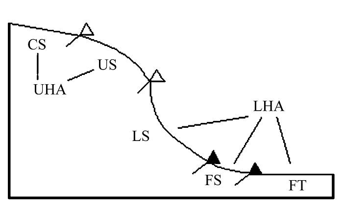
图1 丘陵地区微地形区分模式图。CS: 顶坡; US: 上部边坡; LS: 下部边坡; FS: 麓坡; FT: 泛滥性阶地; UHA: 上部坡面; LHA: 下部坡面。△和▲分别代表凸和凹的坡面变换。
Fig. 1 The schematic diagram of the micro-landforms in a hilly area. CS, Crest slope; US, Upper sideslope. LS, Lower sideslope; FS, Foot slope; FT, Flood terrace; UHA, Upper hillside area; LHA, Lower hillside area. △ and ▲ indicate convex and concave break of slope, respectively.
| 物种 Species | 种子数量 No. of seeds | 物种 Species | 种子数量 No. of seeds |
|---|---|---|---|
| 常绿阔叶乔木 Evergreen broad-leaved tree | 枳椇 Hovenia dulcis | 10 | |
| 米槠 Castanopsis carlesii | 16 | 山合欢 Albizia kalkora | 7 |
| 苦槠 C. sclerophylla | 6 | 油桐 Vernicia fordii | 4 |
| 长叶石栎 Lithocarpus harlandii | 10 | 楝树 Melia azedarach | 2 |
| 云山青冈 Cyclobalanopsis nubium | 9 | 八角枫 Alangium chinense | 1 |
| 短梗冬青 Ilex buergeri | 248 | 落叶阔叶小乔木 Deciduous broad-leaved sub-tree | |
| 木荷 Schima superba | 82 | 山鸡椒 Litsea cubeba | 27 |
| 杨梅 Myrica rubra | 28 | 白背叶 Mallotus apeltus | 24 |
| 刺叶桂樱 Prunus spinulosa | 4 | 长叶冻绿 Rhamnus crenata | 8 |
| 舟山新木姜子 Neolitsea sericea | 1 | 大青 Clerodendrum cyrtophyllum | 1 |
| 常绿阔叶小乔木 Evergreen broad-leaved sub-tree | 落叶阔叶灌木 Deciduous broad-leaved shrub | ||
| 黑山山矾 Symplocos heishanensis | 258 | 山胡椒 Lindera glauca | 17 |
| 四川山矾 S. setchuensis | 112 | 红脉钓樟 L. rubronervia | 1 |
| 光叶山矾 S. lancifolia | 47 | 山莓 Rubus corchorifolius | 114 |
| 山矾 S. sumuntia | 17 | 盐肤木 Rhus chinensis | 5 |
| 细枝柃 Eurya loquaiana | 1,070 | 山油麻 Trema cannabina var. dielsiana | 3 |
| 细齿叶柃 E. nitida | 42 | 胡枝子 Lespedeza bicolor | 1 |
| 杨桐 Adinandra millettii | 26 | 常绿藤本 Evergreen liana | |
| 杨梅叶蚊母树 Distylium myricoides | 160 | 木防己 Cocculus trilobus | 120 |
| 披针叶茴香 Illicium lanceolatum | 16 | 广东蛇葡萄 Ampelopsis cantoniensis | 95 |
| 交让木 Daphniphyllum macropodum | 8 | 过山枫 Celastrus aculeatus | 23 |
| 赤楠 Syzygium buxifolium | 9 | 羊角藤 Morinda umbellata | 9 |
| 常绿阔叶灌木 Evergreen broad-leaved shrub | 白花野木瓜 Stauntonia leucantha | 1 | |
| 格药柃 Eurya muricata | 119 | 落叶藤本 Deciduous liana | |
| 毛枝连蕊茶 Camellia fraterna | 19 | 刺葡萄 Vitis davidii | 2 |
| 老鼠矢 Symplocos stellaris | 70 | 多年生草本 Perennial herb | |
| 胡颓子 Elaeagnus pungens | 1 | 淡竹叶 Lophatherum gracile | 26 |
| 寒莓 Rubus buergeri | 26 | 三脉紫菀 Aster ageratoides | 14 |
| 落叶阔叶乔木 Deciduous broad-leaved tree | 何首乌 Polygonum multiflorum | 12 | |
| 橄榄槭 Acer olivaceum | 146 | 显子草 Phaenosperma globosum | 5 |
| 天童锐角槭 A. acutum var. tientungense | 62 | 大吴风草 Farfugium japonicum | 2 |
| 西川朴 Celtis vandervoetiana | 66 | 戟叶堇菜 Viola betonicifolia | 2 |
| 糙叶树 Aphananthe aspera | 19 | 酢浆草 Oxalis corniculata | 1 |
| 青钱柳 Cyclocarya paliurus | 6 | 龙芽草 Agrimonia pilosa | 1 |
| 化香 Platycarya strobilacea | 2 | 一年生草本 Annual herb | |
| 雷公鹅耳枥 Carpinus viminea | 1,154 | 求米草 Oplismenus undulatifolius | 23 |
| 南酸枣 Choerospondias axiliaris | 332 | 未定名物种1 Unidentified species 1 | 180 |
| 枫香 Liquidambar formosana | 23 | 未定名物种2 Unidentified species 2 | 40 |
| 小果冬青 Ilex micrococca | 14 | 未定名物种3 Unidentified species 3 | 15 |
表1 天童山森林土壤种子库的物种组成
Table 1 Species composition of soil bank on Tiantong Mountain
| 物种 Species | 种子数量 No. of seeds | 物种 Species | 种子数量 No. of seeds |
|---|---|---|---|
| 常绿阔叶乔木 Evergreen broad-leaved tree | 枳椇 Hovenia dulcis | 10 | |
| 米槠 Castanopsis carlesii | 16 | 山合欢 Albizia kalkora | 7 |
| 苦槠 C. sclerophylla | 6 | 油桐 Vernicia fordii | 4 |
| 长叶石栎 Lithocarpus harlandii | 10 | 楝树 Melia azedarach | 2 |
| 云山青冈 Cyclobalanopsis nubium | 9 | 八角枫 Alangium chinense | 1 |
| 短梗冬青 Ilex buergeri | 248 | 落叶阔叶小乔木 Deciduous broad-leaved sub-tree | |
| 木荷 Schima superba | 82 | 山鸡椒 Litsea cubeba | 27 |
| 杨梅 Myrica rubra | 28 | 白背叶 Mallotus apeltus | 24 |
| 刺叶桂樱 Prunus spinulosa | 4 | 长叶冻绿 Rhamnus crenata | 8 |
| 舟山新木姜子 Neolitsea sericea | 1 | 大青 Clerodendrum cyrtophyllum | 1 |
| 常绿阔叶小乔木 Evergreen broad-leaved sub-tree | 落叶阔叶灌木 Deciduous broad-leaved shrub | ||
| 黑山山矾 Symplocos heishanensis | 258 | 山胡椒 Lindera glauca | 17 |
| 四川山矾 S. setchuensis | 112 | 红脉钓樟 L. rubronervia | 1 |
| 光叶山矾 S. lancifolia | 47 | 山莓 Rubus corchorifolius | 114 |
| 山矾 S. sumuntia | 17 | 盐肤木 Rhus chinensis | 5 |
| 细枝柃 Eurya loquaiana | 1,070 | 山油麻 Trema cannabina var. dielsiana | 3 |
| 细齿叶柃 E. nitida | 42 | 胡枝子 Lespedeza bicolor | 1 |
| 杨桐 Adinandra millettii | 26 | 常绿藤本 Evergreen liana | |
| 杨梅叶蚊母树 Distylium myricoides | 160 | 木防己 Cocculus trilobus | 120 |
| 披针叶茴香 Illicium lanceolatum | 16 | 广东蛇葡萄 Ampelopsis cantoniensis | 95 |
| 交让木 Daphniphyllum macropodum | 8 | 过山枫 Celastrus aculeatus | 23 |
| 赤楠 Syzygium buxifolium | 9 | 羊角藤 Morinda umbellata | 9 |
| 常绿阔叶灌木 Evergreen broad-leaved shrub | 白花野木瓜 Stauntonia leucantha | 1 | |
| 格药柃 Eurya muricata | 119 | 落叶藤本 Deciduous liana | |
| 毛枝连蕊茶 Camellia fraterna | 19 | 刺葡萄 Vitis davidii | 2 |
| 老鼠矢 Symplocos stellaris | 70 | 多年生草本 Perennial herb | |
| 胡颓子 Elaeagnus pungens | 1 | 淡竹叶 Lophatherum gracile | 26 |
| 寒莓 Rubus buergeri | 26 | 三脉紫菀 Aster ageratoides | 14 |
| 落叶阔叶乔木 Deciduous broad-leaved tree | 何首乌 Polygonum multiflorum | 12 | |
| 橄榄槭 Acer olivaceum | 146 | 显子草 Phaenosperma globosum | 5 |
| 天童锐角槭 A. acutum var. tientungense | 62 | 大吴风草 Farfugium japonicum | 2 |
| 西川朴 Celtis vandervoetiana | 66 | 戟叶堇菜 Viola betonicifolia | 2 |
| 糙叶树 Aphananthe aspera | 19 | 酢浆草 Oxalis corniculata | 1 |
| 青钱柳 Cyclocarya paliurus | 6 | 龙芽草 Agrimonia pilosa | 1 |
| 化香 Platycarya strobilacea | 2 | 一年生草本 Annual herb | |
| 雷公鹅耳枥 Carpinus viminea | 1,154 | 求米草 Oplismenus undulatifolius | 23 |
| 南酸枣 Choerospondias axiliaris | 332 | 未定名物种1 Unidentified species 1 | 180 |
| 枫香 Liquidambar formosana | 23 | 未定名物种2 Unidentified species 2 | 40 |
| 小果冬青 Ilex micrococca | 14 | 未定名物种3 Unidentified species 3 | 15 |
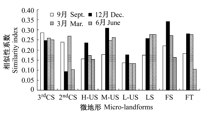
图2 天童山不同微地形土壤种子库与地上植被的相似性。3rdCS: 3级顶坡; 2nd CS: 2级顶坡; US: 上部边坡; LS: 下部边坡; FS: 麓坡; FT: 泛滥性阶地。
Fig. 2 Similarity of soil seed bank and above-ground vegetation among different micro-landforms in Tiantong Mountain. 3rdCS, Third crest slope; 2nd CS, Second crest slope; US, Upper sideslope; LS, Lower sideslope; FS, Foot slope; FT, Flood terrace.
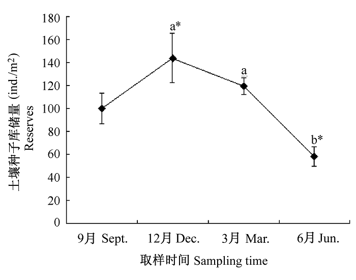
图3 天童山土壤种子库储量的时间动态。不同字母表示不同取样时间内有显著性差异(P<0.05), 注*者表示有极显著性差异(P<0.01)。
Fig. 3 The temporal dynamics of soil seed bank reserves in Tiantong Mountain. Different letters indicate different significantly (P<0.05) in each sampling time, the letters marked with “*” indicate different significantly (P<0.01).
| 时间 Sampling time | 3级顶坡 3rdCS | 2级顶坡 2ndCS | 高上部边坡 H-US | 中上部边坡 M-US | 低上部边坡 L-US | 下部边坡 LS | 麓坡 FS | 泛滥性阶地 FT | 平均Average |
|---|---|---|---|---|---|---|---|---|---|
| 2008年9月 Sept., 2008 | 114±48 | 121±54 | 92±26 | 92±14 | 29±9 | 87±22 | 155±19 | 108±37 | 100±13 |
| 2008年12月 Dec., 2008 | 335±17 | 99±37 | 75±14 | 153±49 | 29±13 | 123±51 | 151±60 | 187±56 | 144±33 |
| 2009年3月 Mar., 2009 | 285±108 | 124±31 | 34±10 | 54±27 | 17±5 | 118±53 | 186±32 | 137±23 | 119±31 |
| 2009年6月 June, 2009 | 65±22 | 115±23 | 15±5 | 43±10 | 28±2 | 55±34 | 75±41 | 53±15 | 56±11 |
| 平均值 Average | 200±65 | 115±6 | 54±18 | 86±25 | 26±3 | 96±16 | 142±24 | 121±28 | 105±19 |
表2 4个取样时间不同微地形土壤种子库储量(ind./m2, 平均值±标准误)
Table 2 Soil seed bank reserves in different micro-landforms in four sampling times (ind./m2, mean±SE)
| 时间 Sampling time | 3级顶坡 3rdCS | 2级顶坡 2ndCS | 高上部边坡 H-US | 中上部边坡 M-US | 低上部边坡 L-US | 下部边坡 LS | 麓坡 FS | 泛滥性阶地 FT | 平均Average |
|---|---|---|---|---|---|---|---|---|---|
| 2008年9月 Sept., 2008 | 114±48 | 121±54 | 92±26 | 92±14 | 29±9 | 87±22 | 155±19 | 108±37 | 100±13 |
| 2008年12月 Dec., 2008 | 335±17 | 99±37 | 75±14 | 153±49 | 29±13 | 123±51 | 151±60 | 187±56 | 144±33 |
| 2009年3月 Mar., 2009 | 285±108 | 124±31 | 34±10 | 54±27 | 17±5 | 118±53 | 186±32 | 137±23 | 119±31 |
| 2009年6月 June, 2009 | 65±22 | 115±23 | 15±5 | 43±10 | 28±2 | 55±34 | 75±41 | 53±15 | 56±11 |
| 平均值 Average | 200±65 | 115±6 | 54±18 | 86±25 | 26±3 | 96±16 | 142±24 | 121±28 | 105±19 |
| 取样时间 Sampling time | 枯枝落叶层 Litter layer | 0-2 cm土层 0-2 cm soil layer | 2-5 cm土层 2-5 cm soil layer | 5-10 cm土层 5-10 cm soil layer |
|---|---|---|---|---|
| 2008年9月 Sept. 2008 | 22±4 | 29±6 | 29±6 | 20±5 |
| 2008年12月 Dec. 2008 | 35±7 | 50±9 | 35±5 | 25±4 |
| 2009年3月 Mar. 2009 | 16±3 | 38±4 | 26±3 | 40±4 |
| 2009年6月 June 2009 | 3±1 | 15±3 | 18±3 | 21±4 |
| 平均值 Average | 19±7 | 33±7 | 27±4 | 26±5 |
表3 4次取样时间不同土层土壤种子库储量(ind./m2, 平均值±标准误)
Table 3 Soil seed bank reserves in different vertical soil layers in four sampling times (ind./m2, mean±SE)
| 取样时间 Sampling time | 枯枝落叶层 Litter layer | 0-2 cm土层 0-2 cm soil layer | 2-5 cm土层 2-5 cm soil layer | 5-10 cm土层 5-10 cm soil layer |
|---|---|---|---|---|
| 2008年9月 Sept. 2008 | 22±4 | 29±6 | 29±6 | 20±5 |
| 2008年12月 Dec. 2008 | 35±7 | 50±9 | 35±5 | 25±4 |
| 2009年3月 Mar. 2009 | 16±3 | 38±4 | 26±3 | 40±4 |
| 2009年6月 June 2009 | 3±1 | 15±3 | 18±3 | 21±4 |
| 平均值 Average | 19±7 | 33±7 | 27±4 | 26±5 |
| [1] | Ambrosiol L, Dorado JY, Delmonte JP (1997) Assessment of the sample size to estimate the weed seed bank in soil. Weed Research, 37, 129-137. |
| [2] | An SQ (安树青), Lin XY (林向阳), Hong BG (洪必恭) (1996) A preliminary study on the soil seed banks of the dominant vegetation forms on Baohua Mountain. Acta Phytoecologica Sinica (植物生态学报), 20, 41-50. (in Chinese with English abstract) |
| [3] | Baskin CC (2005) Seed to seed. Trends in Ecology and Evolution, 20, 426-427. |
| [4] | Bekker RM, Bakker JP, Grandin U, Kalamees R, Milberg P, Poschlod P, Thompson K, Willems JH (1998) Seed size, shape and vertical distribution in the soil: indicators of seed longevity. Functional Ecology, 12, 834-842. |
| [5] | Bossuyt B, Heyn M, Hermy M (2002) Seed bank and vegetation composition of forest stands of varying age in central Belgium: consequences for regeneration of ancient forest vegetation. Plant Ecology, 162, 33-48. |
| [6] | Du XJ, Guo QF, Gao XM, Ma KP (2007) Seed rain, soil seed bank, seed loss and regeneration of Castanopsis fargesii (Fagaceae) in a subtropical evergreen broad-leaved forest. Forest Ecology and Management, 238, 212-219. |
| [7] | Dutoit T, Alard D (1995) Permanent seed banks in chalk grassland under various management regimes: their role in the restoration of species-rich plant communities. Biodiversity and Conservation, 4, 939-950. |
| [8] | Hara M, Hiroshi K, Oono K (1996) Relationship between micro-landform and vegetation structure in an evergreen broad-leaved forest on Okinawa Island, S-W Japan. Natural History Research, 4, 27-35. |
| [9] | Kikuchi T (2001) Vegetation and Landforms. University of Tokyo Press. Tokyo. |
| [10] | Kjellson G (1992) Seed banks in Danish deciduous forests: species composition, seed influx and distribution pattern in soil. Ecography, 15, 86-100. |
| [11] | Liu JM (刘济明) (2000) A preliminary study on the soil seed bank dynamics of the Distylium chinensis community in the Maolan karst forest. Acta Phytoecologica Sinica (植物生态学报), 24, 366-374. (in Chinese with English abstract) |
| [12] | Nagamatsu D, Mirura O (1997) Soil disturbance regime in relation to micro-scale landforms and its effects on vegetation structure in a hilly area in Japan. Plant Ecology, 133, 191-200. |
| [13] | National Service Center for State-Owned Forest Farms and Forest Seed and Seedling Affairs of the Forestry Ministry (国家林业局国有林场和林木种苗工作总站) (2003) Seeds of Woody Plants in China (中国木本植物种子). China Forestry Publishing House, Beijing. (in Chinese) |
| [14] | Pake CE, Venable DL (1996) Seed banks in desert annuals: implications for persistence and coexistence in variable environments. Ecology, 77, 1427-1435. |
| [15] | Russi L, Cocks PS, Roberts EH (1992) Seed bank dynamics in Mediterranean grassland. Journal of Applied Ecology, 29, 763-771. |
| [16] | Roberts HA (1981) Seed banks in soil. In: Advances in Applied Biology (ed. Coaker TH), pp. 1-55, Academic Press, London. |
| [17] | Shen YX, Liu WY, Cao M, Li YH (2007) Seasonal variation in density and species richness of soil seed-banks in karst forests and degraded vegetation in central Yunnan, SW China. Seed Science Research, 17, 99-107. |
| [18] | Shen ZH (沈泽昊), Lü N (吕楠), Zhao J (赵俊) (2004) The topographic pattern of seed rain of a mountain mixed evergreen and deciduous forest community. Acta Ecologica Sinica (生态学报), 24, 1981-1987. (in Chinese with English abstract) |
| [19] | Song RS (宋瑞生), Yu MJ (于明坚), Li MH (李铭红), Chen WX (陈卫新), Jiang YF (姜云飞), Wen XQ (闻小清) (2008) Soil seed bank and natural regeneration of fragmented evergreen broad-leaved forest. Acta Ecologica Sinica (生态学报), 28, 2554-2562. (in Chinese with English abstract) |
| [20] | Song YC (宋永昌), Wang XR (王祥荣) (1995) Vegetation and Flora of Tiantong National Forest Park, Zhejiang Province (浙江天童国家森林公园的植被和区系). Shanghai Science and Technology Document Press, Shanghai. (in Chinese) |
| [21] | Thompson K, Grime JP (1979) Seasonal variation in the seed banks of herbaceous species in ten contrasting habitats. Journal of Ecology, 67, 893-921. |
| [22] | Wu JG (邬建国) (2007) Landscape Ecology: Pattern, Process, Scale and Hierarchy (景观生态学: 格局、过程、尺度与等级), 2nd edn. Higher Education Press, Beijing. (in Chinese) |
| [23] | Wu ZY (吴征镒) (1980) Vegetation of China (中国植被). Science Press, Beijing. (in Chinese) |
| [24] | Xiong LM (熊利民), Zhong ZC (钟章成), Li XG (李旭光), Wang L (汪莉) (1992) A preliminary study on the soil seed banks of different successional stages of subtropical evergreen broadleaved forest. Acta Phytoecologica et Geobotanica Sinica (植物生态学与地植物学学报), 16, 249-257. (in Chinese with English abstract) |
| [25] | Yang YC (杨永川), Da LJ (达良俊), You WH (由文辉) (2005) Vegetation structure in relation to micro-landform in Tiantong National Forest Park, Zhejiang, China. Acta Ecologica Sinica (生态学报), 25, 2830-2840. (in Chinese with English abstract) |
| [26] | Yang YC (杨永川) (2005) Differentiation and Maintenance of Vegetation Patterns Along the Topographical Gradients in Mid-Subtropical Hilly and Lower Mountainous Area in East (中国中亚热带东部低山丘陵地形梯度上植被的分异及其形成和维持机制). PhD dissertation, East China Normal University, Shanghai. (in Chinese with English abstract) |
| [27] | Yang YC (杨永川), Da LJ (达良俊) (2006) A brief review of studies on differentiation of vegetation pattern along a topographic gradient in hilly regions. Journal of Plant Ecology (植物生态学报), 30, 504-513. (in Chinese with English abstract) |
| [28] | Yin HJ (尹华军), Liu Q (刘庆) (2005) Seed rain and soil seed banks of Picea asperata in subalpine spruce forests, western Sichuan, China. Acta Phytoecologica Sinica (植物生态学报), 29, 108-115. (in Chinese with English abstract) |
| [29] | Yin LP (印丽萍), Yan SY (颜玉树) (1996) Identification of Weed Seeds with Colored Photos (杂草种子图鉴). China Agriculture Science and Technology Press, Beijing. (in Chinese) |
| [30] | Yu SL (于顺利), Chen HW (陈宏伟), Lang NJ (郎南军) (2007) The classification systems of soil seed banks and seed persistence in soil. Acta Ecologica Sinica (生态学报), 27, 2099-2108. (in Chinese with English abstract) |
| [1] | 邢丁亮. 空间聚集度指数及其估计不确定性对聚集度-多度关系的影响[J]. 生物多样性, 2026, 34(1): 25398-. |
| [2] | 王映霓, 雷晶晶, 包雨鑫, 廖丹, 张新娜, 王娟. 性别系统对东北天然针阔混交林中优势树种空间分布格局的影响[J]. 生物多样性, 2025, 33(11): 25101-. |
| [3] | 李蓉姣, 董江海, 郑文芳, 刘入源, 赵立娟, 高瑞贺. 关帝山不同海拔杨桦混交林土壤动物多样性特征及其影响因素[J]. 生物多样性, 2024, 32(9): 24070-. |
| [4] | 李世东. 中国和美国国家公园时空发展及驱动因素[J]. 生物多样性, 2023, 31(6): 23040-. |
| [5] | 陈哲涵, 尹进, 叶吉, 刘冬伟, 毛子昆, 房帅, 蔺菲, 王绪高. 增温对东北温带次生林草本群落季节动态的影响[J]. 生物多样性, 2023, 31(5): 23059-. |
| [6] | 陈宏, 冼晓青, 陈宜雪, 林娜, 王苗苗, 李志鹏, 赵健. 海岛型城市红火蚁发生程度空间格局及驱动因子——以福建海坛岛为例[J]. 生物多样性, 2023, 31(5): 22501-. |
| [7] | 张伟, 翟东东, 熊飞, 刘红艳, 陈元元, 王莹, 廖传松, 段辛斌, 田辉伍, 邓华堂, 陈大庆. 三峡库区鱼类群落结构和功能多样性[J]. 生物多样性, 2023, 31(2): 22136-. |
| [8] | 田希, 刘文聪, 饶杰生, 王晓凤, 杨涛, 陈稀, 张秋雨, 刘其明, 徐衍潇, 张旭, 沈泽昊. 云南鸡足山半湿润常绿阔叶林的林隙干扰格局与成因[J]. 生物多样性, 2023, 31(11): 23219-. |
| [9] | 付飞, 魏慧玉, 常育腾, 王备新, 陈凯. 澜沧江中游水生昆虫生活史和生态学性状多样性的海拔格局: 气候和土地利用的影响[J]. 生物多样性, 2022, 30(5): 21332-. |
| [10] | 陈燕南, 梁铖, 陈军. 亚热带不同树种组成森林中土壤甲螨群落结构特征: 以江西新岗山为例[J]. 生物多样性, 2022, 30(12): 22334-. |
| [11] | 孙佳欢, 刘冬, 朱家祺, 张书宁, 高梅香. 小麦-玉米轮作农田土壤螨多样性空间分布格局[J]. 生物多样性, 2022, 30(12): 22292-. |
| [12] | 刘笑彤, 田艺佳, 刘汉文, 梁翠影, 姜思维, 梁文举, 张晓珂. 下辽河平原农田土壤线虫群落组成的季节变化[J]. 生物多样性, 2022, 30(12): 22222-. |
| [13] | 靳新影, 张肖冲, 金多, 陈韵, 李靖宇. 腾格里沙漠东南缘不同生物土壤结皮细菌多样性及其季节动态特征[J]. 生物多样性, 2020, 28(6): 718-726. |
| [14] | 董乙乂,彭艳琼,王波. 垂叶榕榕小蜂群落及种间互作网络季节动态[J]. 生物多样性, 2020, 28(4): 496-503. |
| [15] | 宋垚彬, 徐力, 段俊鹏, 张卫军, 申屠晓露, 李天翔, 臧润国, 董鸣. 西藏极小种群野生植物密叶红豆杉种群的性比及雌雄空间格局[J]. 生物多样性, 2020, 28(3): 269-276. |
| 阅读次数 | ||||||
|
全文 |
|
|||||
|
摘要 |
|
|||||
备案号:京ICP备16067583号-7
Copyright © 2026 版权所有 《生物多样性》编辑部
地址: 北京香山南辛村20号, 邮编:100093
电话: 010-62836137, 62836665 E-mail: biodiversity@ibcas.ac.cn
![]()