
生物多样性 ›› 2023, Vol. 31 ›› Issue (5): 22501. DOI: 10.17520/biods.2022501 cstr: 32101.14.biods.2022501
所属专题: 昆虫多样性与生态功能; 生物入侵
陈宏1, 冼晓青2, 陈宜雪3, 林娜1, 王苗苗1, 李志鹏1, 赵健1,*( )
)
收稿日期:2022-08-30
接受日期:2022-12-08
出版日期:2023-05-20
发布日期:2023-05-19
通讯作者:
* E-mail: 基金资助:
Hong Chen1, Xiaoqing Xian2, Yixue Chen3, Na Lin1, Miaomiao Wang1, Zhipeng Li1, Jian Zhao1,*()
Received:2022-08-30
Accepted:2022-12-08
Online:2023-05-20
Published:2023-05-19
Contact:
* E-mail: 摘要:
红火蚁(Solenopsis invicta)是极具危险性的外来入侵物种, 研究海岛在城市化发展中红火蚁发生程度的空间格局及驱动因子, 对保护海岛生态安全具有重要意义。本研究以福建省东部的海坛岛为例, 运用核密度、空间自相关模型分析红火蚁发生程度空间格局, 进一步运用地理探测器揭示环境因子(8种)、社会经济因子(10种)以及两类因子交互作用对红火蚁发生程度的影响。结果显示: 研究区红火蚁发生程度空间密度表现为不均匀聚集特征, 农田发生程度最为严重(高-高聚集)、园林绿化用地次之(高-低聚集和低-低聚集)、居民区周边最轻, 且发生区域呈现正向空间自相关关系。18种影响因子对红火蚁发生程度空间分异解释度的q值范围为0.014-0.278。从整体上看, 两类因子对红火蚁发生程度的影响存在差异, 且社会经济因子q值平均数高于环境因子。对红火蚁发生程度影响最大的经济因子是农村人口数量(q = 0.278), 其次为乡镇面积(q = 0.268)。在环境因子中, 土壤类型(q = 0.172)和年均降水量(q = 0.149)的影响力较强。环境因子与社会经济因子两两叠加作用都将正向增强红火蚁的发生程度, 其中, 乡镇面积与邻近景区距离、年均降水量与邻近景区距离两组因子交互作用对红火蚁发生程度的影响力最大(q = 0.466)。本研究结果表明农业耕作、城镇化建设中绿化苗木引种、道路交通运输对海岛型城市红火蚁发生程度的空间格局起到关键性作用。因此, 在防控中不仅要加强对调运苗木和往来货物的检疫, 还应采取因地适宜的防控措施, 有效抑制红火蚁种群数量和扩散速度。
陈宏, 冼晓青, 陈宜雪, 林娜, 王苗苗, 李志鹏, 赵健 (2023) 海岛型城市红火蚁发生程度空间格局及驱动因子——以福建海坛岛为例. 生物多样性, 31, 22501. DOI: 10.17520/biods.2022501.
Hong Chen, Xiaoqing Xian, Yixue Chen, Na Lin, Miaomiao Wang, Zhipeng Li, Jian Zhao (2023) Spatial pattern and driving factors on the prevalence of red imported fire ant (Solenopsis invicta) in island cities: A case study of Haitan Island, Fujian. Biodiversity Science, 31, 22501. DOI: 10.17520/biods.2022501.
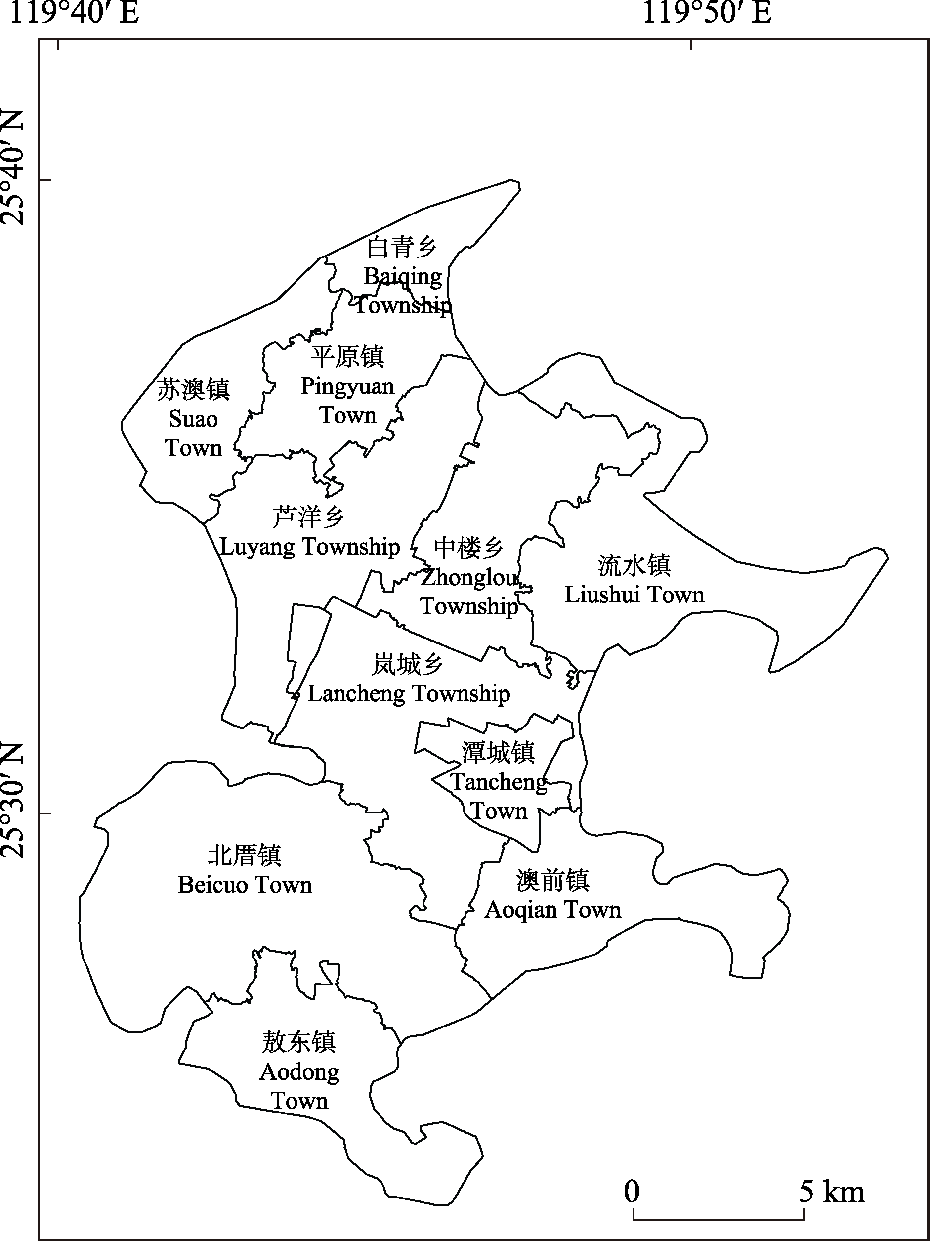
图1 研究区位置
Fig. 1 Location of study area
| 交互关系 Interaction relationship | 交互作用 Interaction effect |
|---|---|
| q(x1∩x2) < Min(q(x1), q(x2)) | 非线性减弱 Nonlinear attenuation |
| Min(q(x1), q(x2)) < q(x1∩x2) < Max(q(x1), q(x2)) | 单因子非线性减弱 One-factor nonlinear attenuation |
| q(x1∩x2) > Max(q(x1), q(x2)) | 双因子增强 Two-factor enhancement |
| q(x1∩x2) = q(x1) + q(x2) | 独立 Independence |
| q(x1∩x2) > q(x1) + q(x2) | 非线性增强 Nonlinear enhancement |
表1 影响因子交互关系及作用
Table 1 Interaction relationship and effect of impact factors
| 交互关系 Interaction relationship | 交互作用 Interaction effect |
|---|---|
| q(x1∩x2) < Min(q(x1), q(x2)) | 非线性减弱 Nonlinear attenuation |
| Min(q(x1), q(x2)) < q(x1∩x2) < Max(q(x1), q(x2)) | 单因子非线性减弱 One-factor nonlinear attenuation |
| q(x1∩x2) > Max(q(x1), q(x2)) | 双因子增强 Two-factor enhancement |
| q(x1∩x2) = q(x1) + q(x2) | 独立 Independence |
| q(x1∩x2) > q(x1) + q(x2) | 非线性增强 Nonlinear enhancement |
| 类别 Category | 影响因子 Impact factors | 数据来源 Data sources |
|---|---|---|
| 环境因子 Environmental factors | 数字高程模型 Digital elevation model (DEM) (x1) | SRTM ( |
| 坡度 Slope (x2) | 通过分析DEM数据获得 Obtained by analyzing DEM data | |
| 地表覆盖 Land cover (x3) | 通过解析Landsat 8卫星影像获得 Obtained by analyzing Landsat 8 satellite images | |
| 归一化植被指数 Normalized difference vegetation index (NDVI) (x4) | ||
| 土壤类型 Soil classification (x5) | 资源环境科学与数据中心 Resource and Environment Science and Data Center (www.resdc.cn) | |
| 年均降水量 Average annual precipitation (x6) | ||
| 年积温 Annual cumulative temperature (x7) | ||
| 干燥度 Drought index (x8) | ||
| 社会经济因子 Socio-economic factors | 夜间灯光 Night light (x9) | 珞珈一号数据 Luojia-1 Data ( |
| 乡镇面积 Township area (x10) | 中国县域统计年鉴(乡镇卷): 2018 China Statistical Yearbook (Township): 2018 (国家统计局农村社会经济调查司, | |
| 村庄数量 Number of villages (x11) | ||
| 农村人口数量 Rural population size (x12) | ||
| 路网密度 Road network density (x13) | 通过分析OSM数据获得 Obtained by analyzing OSM data | |
| 邻近道路距离 Distance to nearby road (x14) | ||
| 邻近道路类型 Adjacent road type (x15) | ||
| 邻近景区距离 Distance to nearby scenic spot (x16) | ||
| 邻近码头距离 Distance to nearby wharf (x17) | ||
| 离跨海大桥距离 Distance to the cross-sea bridge (x18) |
表2 红火蚁发生程度空间格局影响因子及数据来源
Table 2 Data sources for impact factors on spatial pattern of occurrence degree of Solenopsis invicta
| 类别 Category | 影响因子 Impact factors | 数据来源 Data sources |
|---|---|---|
| 环境因子 Environmental factors | 数字高程模型 Digital elevation model (DEM) (x1) | SRTM ( |
| 坡度 Slope (x2) | 通过分析DEM数据获得 Obtained by analyzing DEM data | |
| 地表覆盖 Land cover (x3) | 通过解析Landsat 8卫星影像获得 Obtained by analyzing Landsat 8 satellite images | |
| 归一化植被指数 Normalized difference vegetation index (NDVI) (x4) | ||
| 土壤类型 Soil classification (x5) | 资源环境科学与数据中心 Resource and Environment Science and Data Center (www.resdc.cn) | |
| 年均降水量 Average annual precipitation (x6) | ||
| 年积温 Annual cumulative temperature (x7) | ||
| 干燥度 Drought index (x8) | ||
| 社会经济因子 Socio-economic factors | 夜间灯光 Night light (x9) | 珞珈一号数据 Luojia-1 Data ( |
| 乡镇面积 Township area (x10) | 中国县域统计年鉴(乡镇卷): 2018 China Statistical Yearbook (Township): 2018 (国家统计局农村社会经济调查司, | |
| 村庄数量 Number of villages (x11) | ||
| 农村人口数量 Rural population size (x12) | ||
| 路网密度 Road network density (x13) | 通过分析OSM数据获得 Obtained by analyzing OSM data | |
| 邻近道路距离 Distance to nearby road (x14) | ||
| 邻近道路类型 Adjacent road type (x15) | ||
| 邻近景区距离 Distance to nearby scenic spot (x16) | ||
| 邻近码头距离 Distance to nearby wharf (x17) | ||
| 离跨海大桥距离 Distance to the cross-sea bridge (x18) |
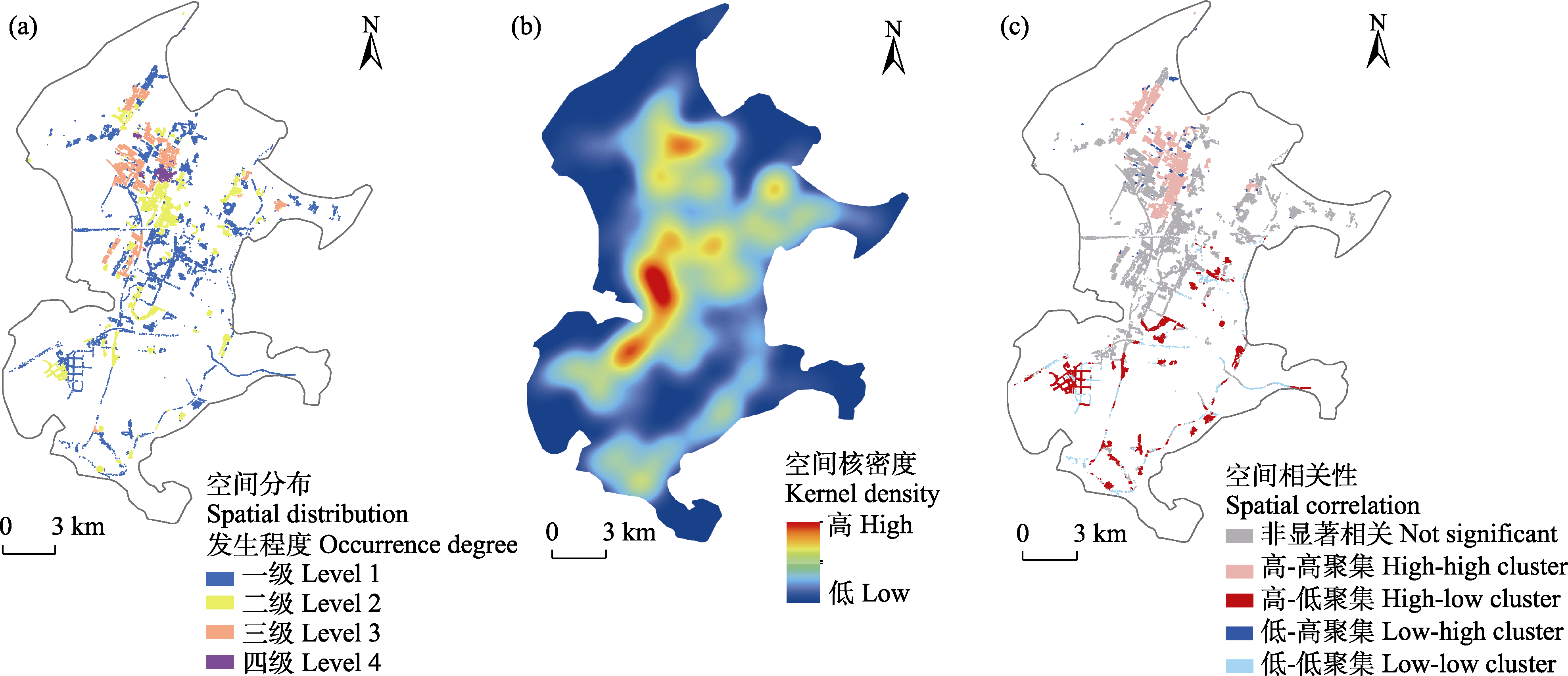
图2 海坛岛红火蚁发生程度空间格局
Fig. 2 Spatial pattern of occurrence degree of Solenopsis invicta in Haitan Island
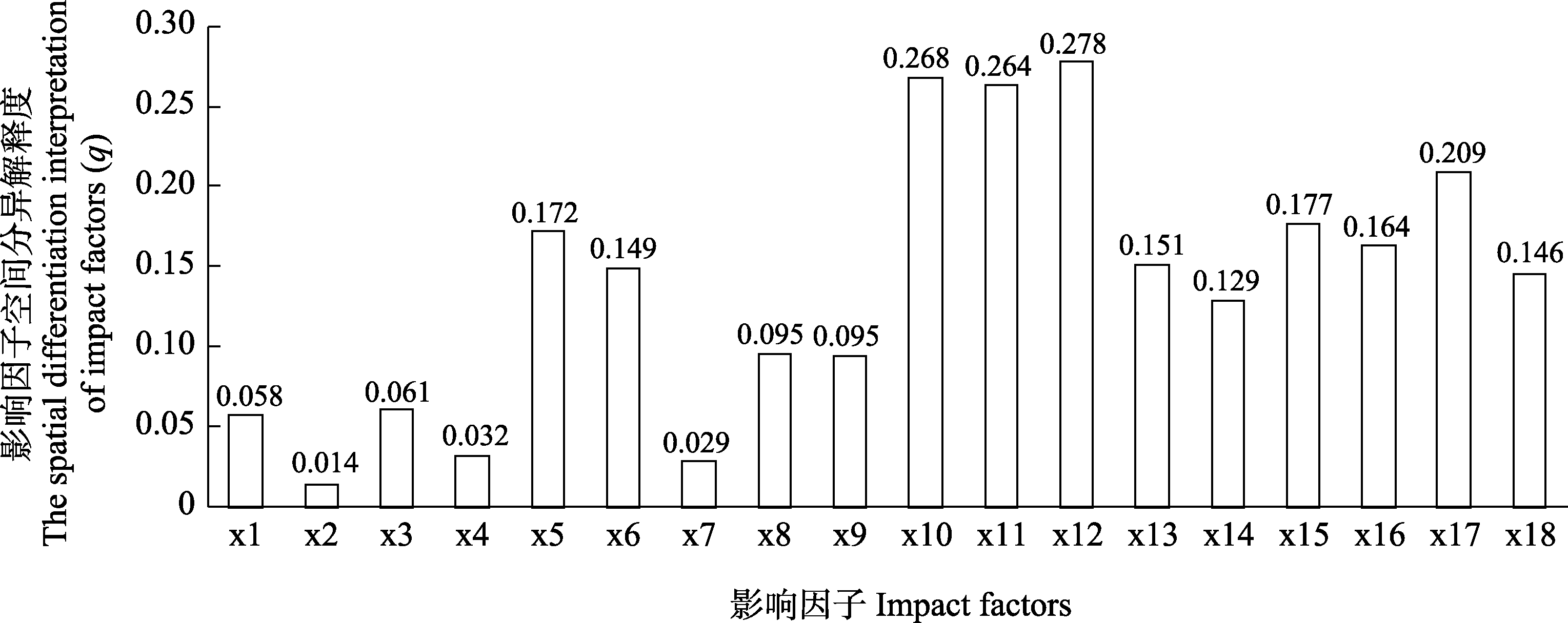
图3 红火蚁发生程度影响因子空间分异解释度探测结果。影响因子代号含义见表2。
Fig. 3 Detection results of spatial differentiation interpretation of factors affecting the occurrence degree of Solenopsis invicta. See Table 2 for the meanings of impact factor codes.
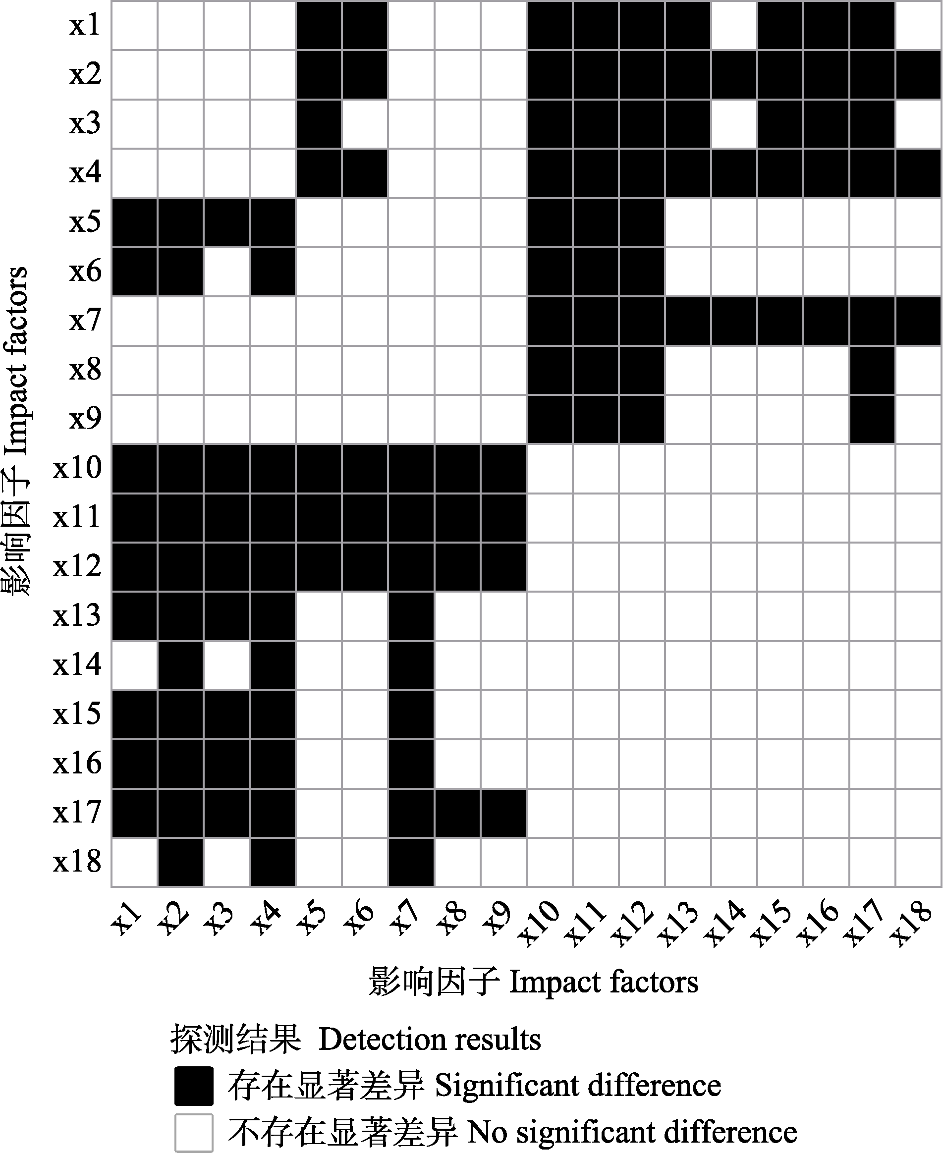
图4 红火蚁发生程度影响因子生态探测结果。影响因子代号含义见表2, F检验显著性水平为0.05。
Fig. 4 Ecological detection results of the impact factors of occurrence degree of Solenopsis invicta. See Table 2 for the meanings of impact factor codes. The significance level of F test is 0.05.
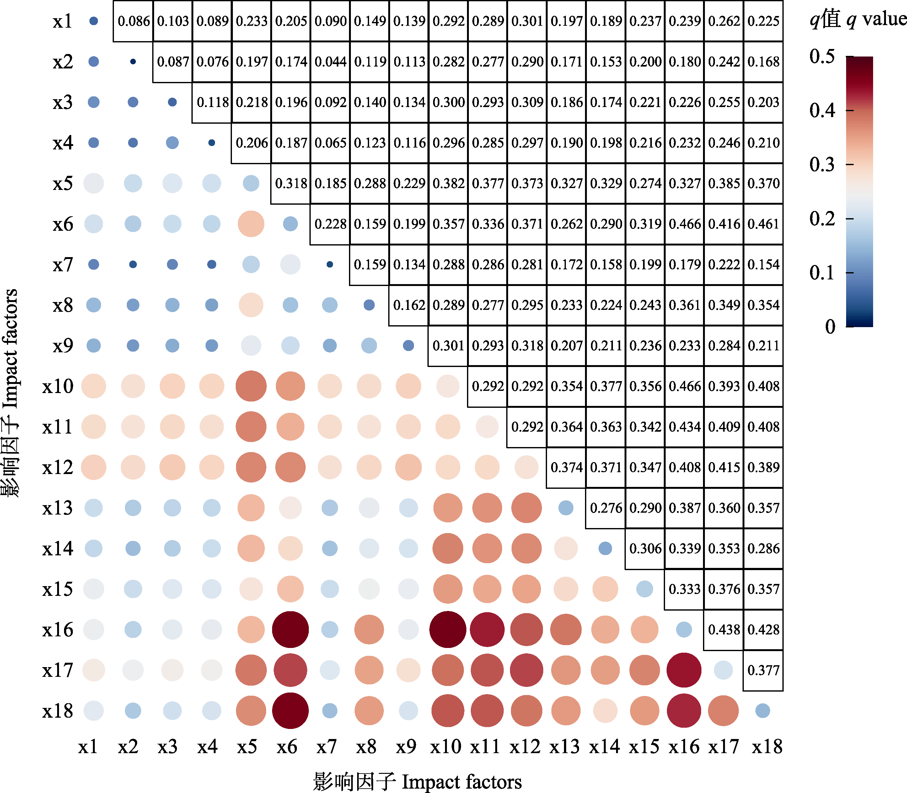
图5 红火蚁发生程度影响因子交互探测结果。影响因子代号含义见表2。
Fig. 5 Interactive detection results of the impact factors of occurrence degree of Solenopsis invicta. See Table 2 for the meanings of impact factor codes.
| [1] |
Anselin L (1995) Local indicators of spatial association—LISA. Geographical Analysis, 27, 93-115.
DOI URL |
| [2] |
Chen C, Gong WR, Hu BS, Zhou GL, Bao YX, Liu FQ (2006) Potential establishment areas of Solenopsis invicta in China: A prediction based on GIS. Chinese Journal of Applied Ecology, 17, 2093-2097. (in Chinese with English abstract)
PMID |
|
[陈晨, 龚伟荣, 胡白石, 周国梁, 包云轩, 刘凤权 (2006) 基于地理信息系统的红火蚁在中国适生区的预测. 应用生态学报, 17, 2093-2097.]
PMID |
|
| [3] | Chen H, Chen YX, Lin N, Li ZP, Chi MX, Zhao J (2021) Construction and application of Solenopsis invicta Buren epidemic investigation system based on mobile location based service. Plant Quarantine, 35(1), 55-60. (in Chinese with English abstract) |
| [陈宏, 陈宜雪, 林娜, 李志鹏, 池美香, 赵健 (2021) 基于移动LBS服务的红火蚁疫情调查系统构建与应用. 植物检疫, 35(1), 55-60.] | |
| [4] | Chen K, Yang CC, Bai LG, Chen Y, Liu R, Chao LM (2021) Effects of natural and human factors on vegetation normalized difference vegetation index based on geographical detectors in Inner Mongolia. Acta Ecologica Sinica, 41, 4963-4975. (in Chinese with English abstract) |
| [陈宽, 杨晨晨, 白力嘎, 陈瑜, 刘锐, 潮洛濛 (2021) 基于地理探测器的内蒙古自然和人为因素对植被NDVI变化的影响. 生态学报, 41, 4963-4975.] | |
| [5] | Chen L, Korzukhin MD, Cheng DF, Lu QG, Wang FX (2006) The analysis for the red imported fire ant Solenopsis invicta (Hymenoptera: Formicidae) distribution in China based on 3S technology, climate model and colony dynamic model. Journal of Plant Protection, 33, 384-390. (in Chinese with English abstract) |
| [陈林, Michael D. Korzukhin, 程登发, 陆庆光, 王福祥 (2006) 基于GIS和气候、种群动态模型的红火蚁适生性分析. 植物保护学报, 33, 384-390.] | |
| [6] | Chen XY, Ma P, Li YC, Hu HF, Li ZY, Gui FR (2015) The prediction on potential distribution of Solenopsis invicta in Yunnan Province based on CLIMEX and ArcGIS. Plant Quarantine, 29(3), 34-39. (in Chinese with English abstract) |
| [陈晓燕, 马平, 李永川, 胡慧芬, 李正跃, 桂富荣 (2015) 基于CLIMEX和ArcGIS预测红火蚁在云南的潜在适生区. 植物检疫, 29(3), 34-39.] | |
| [7] | Chen YX (2020) Investigation of Solenopsis invicta Buren on the main island of Pingtan Comprehensive Experimental Area. Plant Quarantine, 34(2), 77-80. (in Chinese with English abstract) |
| [陈宜雪 (2020) 平潭综合实验区主岛红火蚁疫情调查. 植物检疫, 34(2), 77-80.] | |
| [8] | Department of Rural Socio-Economic Survey, National Bureau of Statistics (2019) China Statistical Yearbook (Township): 2018. China Statistics Press, Beijing. (in Chinese) |
| [国家统计局农村社会经济调查司 (2019) 中国县域统计年鉴—2018. 中国统计出版社, 北京.] | |
| [9] | Gao S, Cao GX, Hong T, Zhao L, Xu M (2018) Dynamic evaluation of ecological security and its driving factors in the process of urbanization of Islands: A case study of Pingtan Island. Acta Ecologica Sinica, 38, 2503-2511. (in Chinese with English abstract) |
| [高升, 曹广喜, 洪滔, 赵林, 徐敏 (2018) 海岛城市化过程中的生态安全动态评价与驱动力分析——以平潭岛为例. 生态学报, 38, 2503-2511.] | |
| [10] | Han ZW (2017) Geographical distribution and affecting factors of the important agricultural heritage systems in China. Chinese Journal of Agricultural Resources and Regional Planning, 38(2), 97-104. (in Chinese with English abstract) |
| [韩宗伟 (2017) 中国农业文化遗产的空间分布特征及影响因素分析. 中国农业资源与区划, 38(2), 97-104.] | |
| [11] | Hu SQ, Xu XR, Zhou WC, Zhang H, Ning ZY (2008) Potential geographical distribution model of Solenopsis invicta Buren in China. Journal of Fujian Agriculture and Forestry University (Natural Science Edition), 37, 205-209. (in Chinese with English abstract) |
| [胡树泉, 徐学荣, 周卫川, 张辉, 宁昭玉 (2008) 红火蚁在中国的潜在地理分布预测模型. 福建农林大学学报(自然科学版), 37, 205-209.] | |
| [12] | Lai HY, Huang BQ, Wu PF (2017) Analysis of the main imapct factors on soil erosion in island city—An example of Pingtan Island, Fujian Province. Research of Soil and Water Conservation, 24(1), 12-17. (in Chinese with English abstract) |
| [赖华燕, 黄博强, 吴鹏飞 (2017) 海岛型城市的土壤侵蚀状况及主要影响因子分析——以福建省平潭岛为例. 水土保持研究, 24(1), 12-17.] | |
| [13] | Li ND, Lu YY, Zeng L, Liang GW, Xu YJ (2006) Study on types of environment, spatial distribution and sampling of red imported fire ant Solenopsis invicta Buren active mounds in Wuchuan, Guangdong Province. Journal of Huazhong Agricultural University (Natural Science Edition), 25, 31-36. (in Chinese with English abstract) |
| [李宁东, 陆永跃, 曾玲, 梁广文, 许益镌 (2006) 广东省吴川红火蚁生境类型、空间分布和抽样技术的研究. 华中农业大学学报, 25, 31-36.] | |
| [14] | Li ZP, Zhao J, Chen YB, Chen H, Lin N, Qiu RZ (2019) Spatial variation and driving factors of invasive plants in Fujian Province, China. Chinese Journal of Applied Ecology, 30, 2682-2690. (in Chinese with English abstract) |
|
[李志鹏, 赵健, 陈业滨, 陈宏, 林娜, 邱荣洲 (2019) 福建省主要入侵植物空间分异及其影响因素. 应用生态学报, 30, 2682-2690.]
DOI |
|
| [15] |
Lin CH, Liu YH, Huang RN, Lin CC, Liu HKH, Wen TH (2022) Modeling geographical invasions of Solenopsis invicta influenced by land-use patterns. Scientific Reports, 12, 11733.
DOI |
| [16] | Liu DQ, Zhang TY, Zhang XL, Zong SX, Huang JX (2022) Spatial stratified heterogeneity and driving force of Anoplophora glabripennis in North China. Transactions of the Chinese Society for Agricultural Machinery, 53(1), 215-223, 369. (in Chinese with English abstract) |
| [刘德庆, 张天媛, 张晓丽, 宗世祥, 黄季夏 (2022) 华北地区光肩星天牛空间分异性及驱动因素研究. 农业机械学报, 53(1), 215-223, 369.] | |
| [17] |
Liu YS, Huang SA, Lin IL, Lin CC, Lai HK, Yang CH, Huang RN (2021) Establishment and social impacts of the red imported fire ant, Solenopsis invicta, (Hymenoptera: Formicidae) in Taiwan. International Journal of Environmental Research and Public Health, 18, 5055.
DOI URL |
| [18] | Lu YY, Liang GW, Zeng L (2008) Study on expansion pattern of red imported fire ant, Solenopsis invicta Buren, in South China. Scientia Agricultura Sinica, 41, 1053-1063. (in Chinese with English abstract) |
| [陆永跃, 梁广文, 曾玲 (2008) 华南地区红火蚁局域和长距离扩散规律研究. 中国农业科学, 41, 1053-1063.] | |
| [19] | Lu YY, Zeng L (2015) 10 years after red imported fire ant found to invade China: History, current situation and trend of its infestation. Plant Quarantine, 29(2), 1-6. (in Chinese with English abstract) |
| [陆永跃, 曾玲 (2015) 发现红火蚁入侵中国10年: 发生历史、现状与趋势. 植物检疫, 29(2), 1-6.] | |
| [20] |
Luo MX, Xiao LF, Chen XH, Lin KQ, Liu B, He ZM, Liu JF, Zheng SQ (2022) Invasive alien plants and invasion risk assessment on Pingtan Island. Sustainability, 14, 923.
DOI URL |
| [21] | Ou J (2008)Study on Risk Assessment for Alien Species in Xiamen. PhD dissertation, Xiamen University, Xiamen. (in Chinese with English abstract) |
| [欧健 (2008) 厦门外来物种入侵风险评估研究. 博士学位论文, 厦门大学, 厦门.] | |
| [22] |
Seebens H, Blackburn TM, Dyer EE, Genovesi P, Hulme PE, Jeschke JM, Pagad S, Pyšek P, Winter M, Arianoutsou M, Bacher S, Blasius B, Brundu G, Capinha C, Celesti-Grapow L, Dawson W, Dullinger S, Fuentes N, Jäger H, Kartesz J, Kenis M, Kreft H, Kühn I, Lenzner B, Liebhold A, Mosena A, Moser D, Nishino M, Pearman D, Pergl J, Rabitsch W, Rojas-Sandoval J, Roques A, Rorke S, Rossinelli S, Roy HE, Scalera R, Schindler S, Štajerová K, Tokarska-Guzik B, van Kleunen M, Walker K, Weigelt P, Yamanaka T, Essl F (2017) No saturation in the accumulation of alien species worldwide. Nature Communications, 8, 14435.
DOI PMID |
| [23] | Shen WJ, Wang YN, Wan FH (2008) Application of analogy deviation to predict potential distribution of Solenopsis invicta Buren (Hymenoptera: Formicidae) and its invasion probability in China. Scientia Agricultura Sinica, 41, 1673-1683. (in Chinese with English abstract) |
| [沈文君, 王雅男, 万方浩 (2008) 应用相似离度法预测红火蚁在中国适生区域及其入侵概率. 中国农业科学, 41, 1673-1683.] | |
| [24] | Wang FX, Wang L, Li XN, Zeng L, Lu YY, Wu SH, Zhu JQ (2009) Guidelines for Quarantine Surveillance of Solenopsis invicta Buren. Standards Press of China, Beijing. (in Chinese) |
| [王福祥, 王琳, 李小妮, 曾玲, 陆永跃, 吴仕豪, 朱景全 (2009) 红火蚁疫情监测规程. 中国标准出版社, 北京.] | |
| [25] | Wang GH, Bai F, Sang WG (2017) Spatial distribution of invasive alien animal and plant species and its influencing factors in China. Plant Science Journal, 35, 513-524. (in Chinese with English abstract) |
| [王国欢, 白帆, 桑卫国 (2017) 中国外来入侵生物的空间分布格局及其影响因素. 植物科学学报, 35, 513-524.] | |
| [26] |
Wang JF, Xu CD (2017) Geodetector: Principle and prospective. Acta Geographica Sinica, 72, 116-134. (in Chinese with English abstract)
DOI |
|
[王劲峰, 徐成东 (2017) 地理探测器: 原理与展望. 地理学报, 72, 116-134.]
DOI |
|
| [27] | Wang L, Lu YY, Zeng L, He XF (2012) Nest distribution and dynamics of colony movement of red imported fire ant in lawn. Journal of South China Agricultural University, 33, 149-153. (in Chinese with English abstract) |
| [王磊, 陆永跃, 曾玲, 何晓芳 (2012) 草坪生境中红火蚁蚁巢空间关系和蚁群迁移动态规律研究. 华南农业大学学报, 33, 149-153.] | |
| [28] | Wang L, Zhao JS (2020) Spatiotemporal distribution pattern of the COVID-19 epidemic and geographical detection. Acta Ecologica Sinica, 40, 6788-6800. (in Chinese with English abstract) |
| [王琳, 赵俊三 (2020) 城市群新冠疫情时空分布格局与分异机制的地理探测. 生态学报, 40, 6788-6800.] | |
| [29] | Wei LF, Li QY, Liu JY, Zhu L (2021) A preliminary investigation on the epidemic of Solenopsis invicta in Haikou. Plant Quarantine, 35(3), 72-76. (in Chinese with English abstract) |
| [韦丽逢, 李黔勇, 刘佳莹, 朱麟 (2021) 海口市红火蚁疫情初步调查. 植物检疫, 35(3), 72-76.] | |
| [30] | Wu XC, Xiao GR (2020) Spatio-temporal distribution patterns of Fusarium interception in coastal areas of China. Ecological Science, 39, 175-183. (in Chinese with English abstract) |
| [吴晓春, 肖桂荣 (2020) 中国沿海地区镰刀菌属口岸截获时空分布格局分析. 生态科学, 39, 175-183.] | |
| [31] | Xu YJ, Lu YY, Zeng L (2010) Spatial distribution characteristics of the nests of newly invaded red imported fire ants. Guangdong Agricultural Sciences, 37(8), 16-19. (in Chinese) |
| [许益镌, 陆永跃, 曾玲 (2010) 新入侵地红火蚁蚁巢的空间分布特征. 广东农业科学, 37(8), 16-19.] | |
| [32] | Xu YJ, Lu YY, Zeng L, Xi YB, Huang J (2006) Study on location expansion of Solenopsis invicta. Journal of South China Agricultural University, 27(1), 34-36. (in Chinese with English abstract) |
| [许益镌, 陆永跃, 曾玲, 席银宝, 黄俊 (2006) 红火蚁局域扩散规律研究. 华南农业大学学报, 27(1), 34-36.] | |
| [33] | Xue DY, Li HM, Han HX, Zhang RZ (2005) A prediction of potential distribution area of Solenopsis invicta in China. Chinese Bulletin of Entomology, 42, 57-60. (in Chinese with English abstract) |
| [薛大勇, 李红梅, 韩红香, 张润志 (2005) 红火蚁在中国的分布区预测. 昆虫知识, 42, 57-60.] | |
| [34] | Zhang X, Chen YX, Hou YM, Xie YX (2015) Expansion of Solenopsis invicta Buren in Fujian Province. Chinese Journal of Applied Entomology, 52, 1376-1384. (in Chinese with English abstract) |
| [张翔, 陈艺欣, 侯有明, 谢毅璇 (2015) 福建省入侵红火蚁扩散规律研究. 应用昆虫学报, 52, 1376-1384.] | |
| [35] |
Zheng WH, Cai F, Chen SL, Zhu J, Qi HS, Zhao SH, Liu JH (2020) Ecological suitability of island development based on ecosystem services value, biocapacity and ecological footprint: A case study of Pingtan Island, Fujian, China. Sustainability, 12, 2553.
DOI URL |
| [1] | 邢丁亮. 空间聚集度指数及其估计不确定性对聚集度-多度关系的影响[J]. 生物多样性, 2026, 34(1): 25398-. |
| [2] | 王映霓, 雷晶晶, 包雨鑫, 廖丹, 张新娜, 王娟. 性别系统对东北天然针阔混交林中优势树种空间分布格局的影响[J]. 生物多样性, 2025, 33(11): 25101-. |
| [3] | 杜聪聪, 冯学宇, 陈志林. 桥头堡效应中气候生态位差异的缩小促进了红火蚁的入侵[J]. 生物多样性, 2024, 32(11): 24276-. |
| [4] | 李世东. 中国和美国国家公园时空发展及驱动因素[J]. 生物多样性, 2023, 31(6): 23040-. |
| [5] | 张伟, 翟东东, 熊飞, 刘红艳, 陈元元, 王莹, 廖传松, 段辛斌, 田辉伍, 邓华堂, 陈大庆. 三峡库区鱼类群落结构和功能多样性[J]. 生物多样性, 2023, 31(2): 22136-. |
| [6] | 田希, 刘文聪, 饶杰生, 王晓凤, 杨涛, 陈稀, 张秋雨, 刘其明, 徐衍潇, 张旭, 沈泽昊. 云南鸡足山半湿润常绿阔叶林的林隙干扰格局与成因[J]. 生物多样性, 2023, 31(11): 23219-. |
| [7] | 付飞, 魏慧玉, 常育腾, 王备新, 陈凯. 澜沧江中游水生昆虫生活史和生态学性状多样性的海拔格局: 气候和土地利用的影响[J]. 生物多样性, 2022, 30(5): 21332-. |
| [8] | 孙佳欢, 刘冬, 朱家祺, 张书宁, 高梅香. 小麦-玉米轮作农田土壤螨多样性空间分布格局[J]. 生物多样性, 2022, 30(12): 22292-. |
| [9] | 宋垚彬, 徐力, 段俊鹏, 张卫军, 申屠晓露, 李天翔, 臧润国, 董鸣. 西藏极小种群野生植物密叶红豆杉种群的性比及雌雄空间格局[J]. 生物多样性, 2020, 28(3): 269-276. |
| [10] | 葛振鹏, 刘权兴. 整体大于部分之和: 生态自组织斑图及其涌现属性[J]. 生物多样性, 2020, 28(11): 1431-1443. |
| [11] | 梁健超, 丁志锋, 张春兰, 胡慧建, 朵海瑞, 唐虹. 青海三江源国家级自然保护区麦秀分区鸟类多样性空间格局及热点区域研究[J]. 生物多样性, 2017, 25(3): 294-303. |
| [12] | 许玥, 李鹏, 刘晔, 张婉君, 秦思雨, 沈泽昊. 怒江河谷入侵植物与乡土植物丰富度的分布格局与影响因子[J]. 生物多样性, 2016, 24(4): 389-398. |
| [13] | 郭屹立, 王斌, 向悟生, 丁涛, 陆树华, 黄俞淞, 黄甫昭, 李冬兴, 李先琨. 广西弄岗北热带喀斯特季节性雨林监测样地种群空间点格局分析[J]. 生物多样性, 2015, 23(2): 183-191. |
| [14] | 陈圣宾, 欧阳志云, 方瑜, 李振基. 中国种子植物特有属的地理分布格局[J]. 生物多样性, 2011, 19(4): 414-423. |
| [15] | 袁志良, 王婷, 朱学灵, 沙迎迎, 叶永忠. 宝天曼落叶阔叶林样地栓皮栎种群空间格局[J]. 生物多样性, 2011, 19(2): 224-231. |
| 阅读次数 | ||||||
|
全文 |
|
|||||
|
摘要 |
|
|||||
备案号:京ICP备16067583号-7
Copyright © 2026 版权所有 《生物多样性》编辑部
地址: 北京香山南辛村20号, 邮编:100093
电话: 010-62836137, 62836665 E-mail: biodiversity@ibcas.ac.cn
![]()