
生物多样性 ›› 2025, Vol. 33 ›› Issue (11): 25080. DOI: 10.17520/biods.2025080 cstr: 32101.14.biods.2025080
罗金怡1, 张纪1, 毕艳玲2,*( ), 陈哲2, 武瑞东1
收稿日期:2025-03-11
接受日期:2025-08-04
出版日期:2025-11-20
发布日期:2025-12-26
通讯作者:
毕艳玲
基金资助:
Jinyi Luo1, Ji Zhang1, Yanling Bi2,*(), Zhe Chen2, Ruidong Wu1
Received:2025-03-11
Accepted:2025-08-04
Online:2025-11-20
Published:2025-12-26
Contact:
Yanling Bi
Supported by:摘要:
加快推进自然保护地体系建设, 提升保护成效, 是我国生态文明建设的核心任务之一。通过在保护规划中系统整合生态系统类型、物种、生态系统服务和自然遗迹等多层次保护对象, 可以使保护地体系更好地维护生态系统完整性和提升保护成效。但是, 目前集成这些多层次保护对象的系统保护规划研究还较为有限。本研究以大理白族自治州为研究区, 选取植物和动物保护物种丰富度、自然植被覆盖度、优先保护植被类型覆盖度、重要生态系统服务类型和自然遗迹6类保护对象, 采用熵值法确定了各类保护对象的权重, 应用系统保护规划模型Zonation, 在考虑已建保护地的基础上, 辨识出潜在保护地分布。结果表明: 基于30%的面积保护目标, 已建保护地约占研究区总面积的8.0%, 潜在保护地约占22.0%; 潜在保护地能够更全面地覆盖物种、生态系统、生态系统服务和自然遗迹等多层次保护对象, 显著提升了已建保护地体系的生态代表性; 潜在保护地主要分布在云龙县、剑川县北部和永平县, 可通过新建保护地或扩大已建保护地等途径加强保护。本研究所采用的集成多层次保护对象的潜在保护地识别方法可以为大理白族自治州和其他地区的自然保护地体系建设工作提供科学支持。
罗金怡, 张纪, 毕艳玲, 陈哲, 武瑞东 (2025) 集成多层次保护对象的潜在保护地识别: 以大理白族自治州为例. 生物多样性, 33, 25080. DOI: 10.17520/biods.2025080.
Jinyi Luo, Ji Zhang, Yanling Bi, Zhe Chen, Ruidong Wu (2025) Identifying potential protected areas by integrating multi-faceted conservation features: A case study of Dali Bai Autonomous Prefecture. Biodiversity Science, 33, 25080. DOI: 10.17520/biods.2025080.
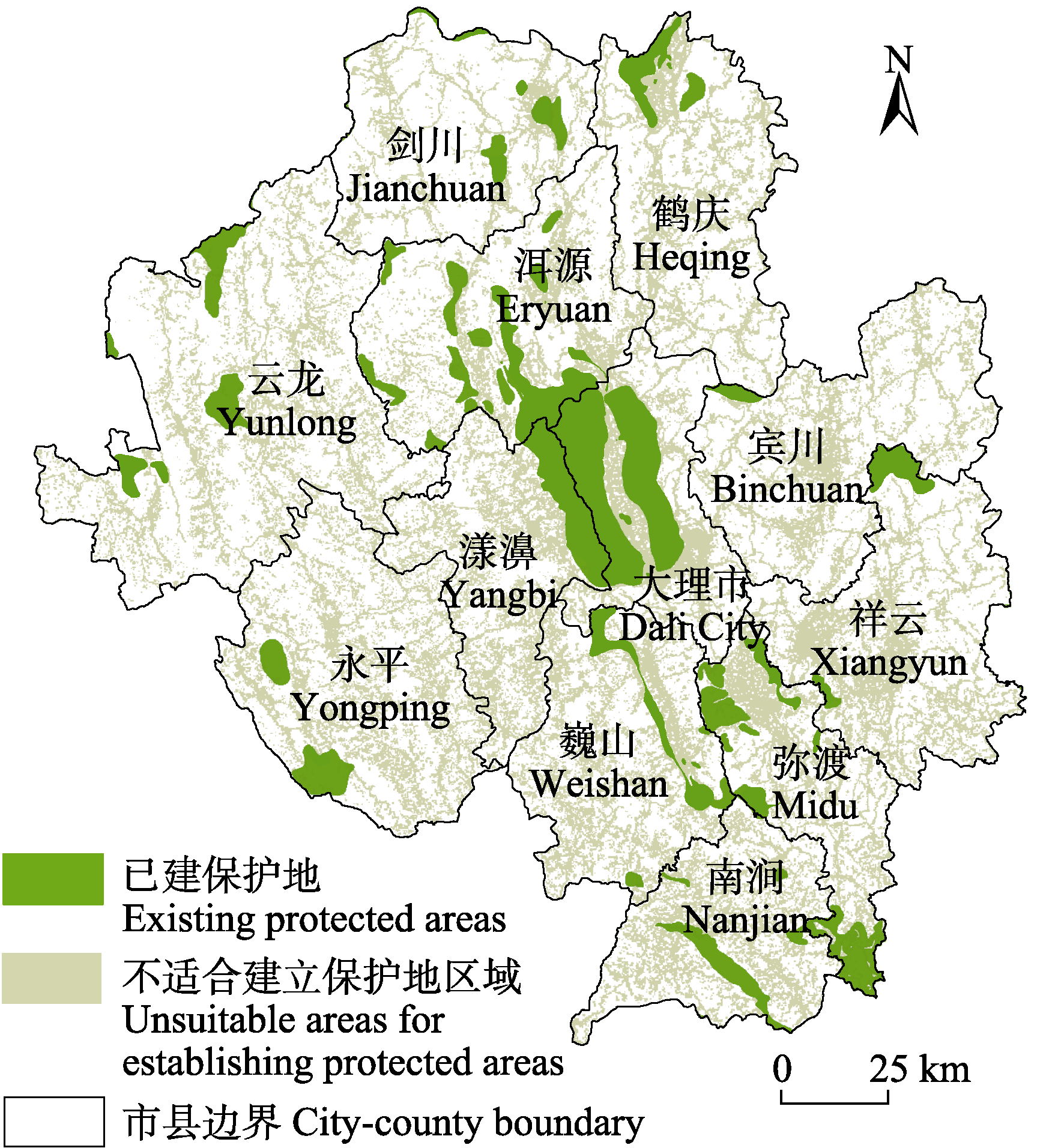
图1 云南省大理白族自治州已建保护地和不适合建立保护地区域的空间分布
Fig. 1 Spatial distribution of existing protected areas and unsuitable areas for establishing protected areas in Dali Bai Autonomous Prefecture, Yunnan Province
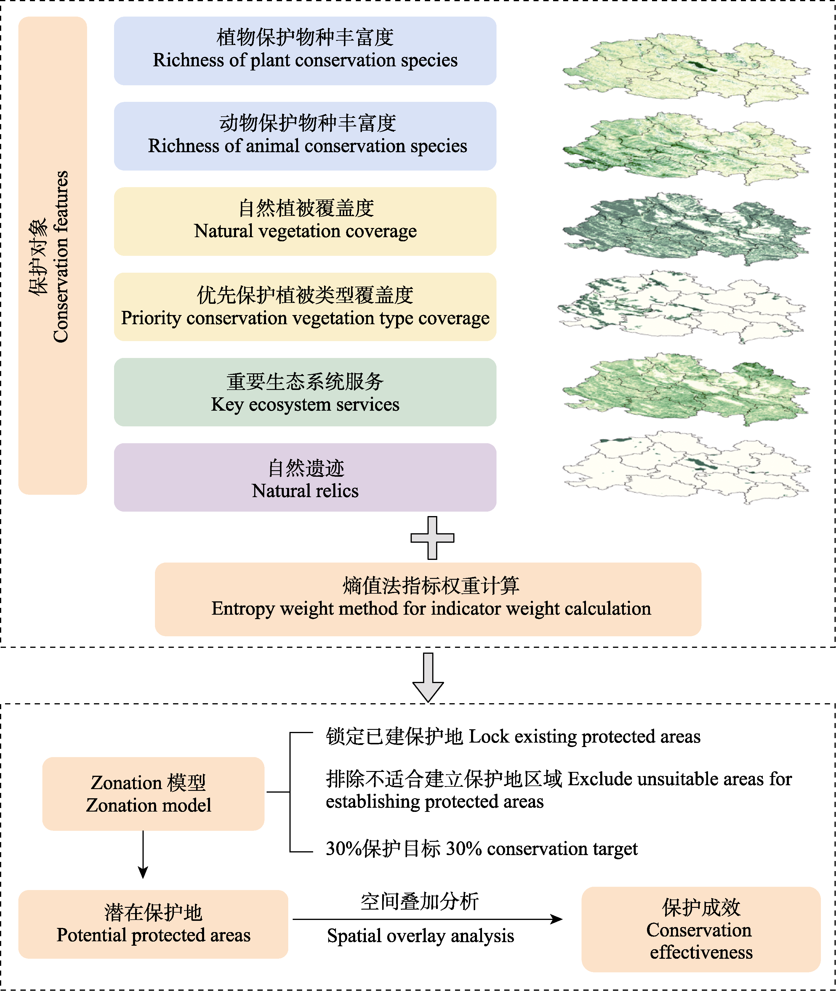
图2 集成多层次保护对象的潜在保护地识别技术路线图
Fig. 2 Technology roadmap for identifying potential protected areas by integrating multi-faceted conservation features
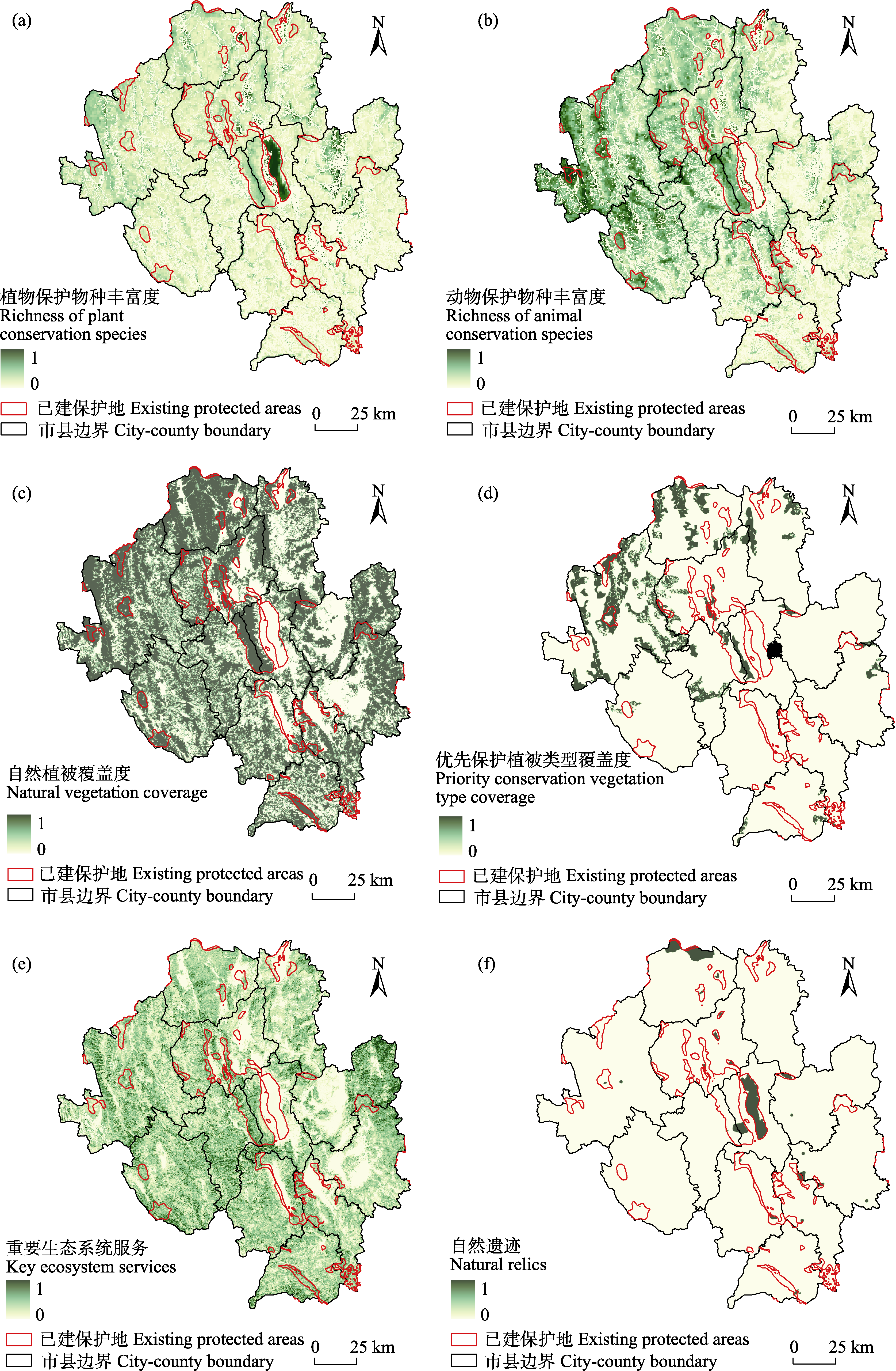
图3 云南省大理白族自治州保护对象空间分布。所有保护对象空间分布数据均采用了极差标准化, 值域范围均为0-1。
Fig. 3 Spatial distributions of conservation features in Dali Bai Autonomous Prefecture, Yunnan Province. The value of all conservation features was normalized via min-max normalization method, ranging from 0 to 1.
| 保护对象 Conservation features | 熵值 Entropy (ej) | 差异化系数 Differentiation coefficient (hj) | 权重 Weight (wj) | 已建保护地覆盖率Coverage of existing protected areas (%) | 潜在保护地覆盖率 Coverage of potential protected areas (%) | 总保护覆盖率 Total protection coverage (%) |
|---|---|---|---|---|---|---|
| 植物保护物种丰富度 Richness of plant conservation species | 0.8553 | 0.1447 | 0.1721 | 83.84 | 82.30 | 90.94 |
| 动物保护物种丰富度 Richness of animal conservation species | 0.8387 | 0.1613 | 0.1918 | 86.74 | 92.27 | 94.48 |
| 自然植被覆盖度 Natural vegetation coverage | 0.9170 | 0.0830 | 0.0987 | 9.56 | 26.02 | 35.58 |
| 优先保护植被类型覆盖度 Priority conservation vegetation type coverage | 0.7573 | 0.2427 | 0.2886 | 10.84 | 74.92 | 85.76 |
| 重要生态系统服务 Key ecosystem services | 0.8797 | 0.1203 | 0.1431 | 9.82 | 32.16 | 41.98 |
| 自然遗迹 Natural relics | 0.9111 | 0.0889 | 0.1057 | 67.16 | 25.10 | 92.26 |
表1 云南省大理白族自治州保护对象的权重值和保护规划成效
Table 1 Weights and conservation planning effectiveness for the conservation features in Dali Bai Autonomous Prefecture, Yunnan Province
| 保护对象 Conservation features | 熵值 Entropy (ej) | 差异化系数 Differentiation coefficient (hj) | 权重 Weight (wj) | 已建保护地覆盖率Coverage of existing protected areas (%) | 潜在保护地覆盖率 Coverage of potential protected areas (%) | 总保护覆盖率 Total protection coverage (%) |
|---|---|---|---|---|---|---|
| 植物保护物种丰富度 Richness of plant conservation species | 0.8553 | 0.1447 | 0.1721 | 83.84 | 82.30 | 90.94 |
| 动物保护物种丰富度 Richness of animal conservation species | 0.8387 | 0.1613 | 0.1918 | 86.74 | 92.27 | 94.48 |
| 自然植被覆盖度 Natural vegetation coverage | 0.9170 | 0.0830 | 0.0987 | 9.56 | 26.02 | 35.58 |
| 优先保护植被类型覆盖度 Priority conservation vegetation type coverage | 0.7573 | 0.2427 | 0.2886 | 10.84 | 74.92 | 85.76 |
| 重要生态系统服务 Key ecosystem services | 0.8797 | 0.1203 | 0.1431 | 9.82 | 32.16 | 41.98 |
| 自然遗迹 Natural relics | 0.9111 | 0.0889 | 0.1057 | 67.16 | 25.10 | 92.26 |
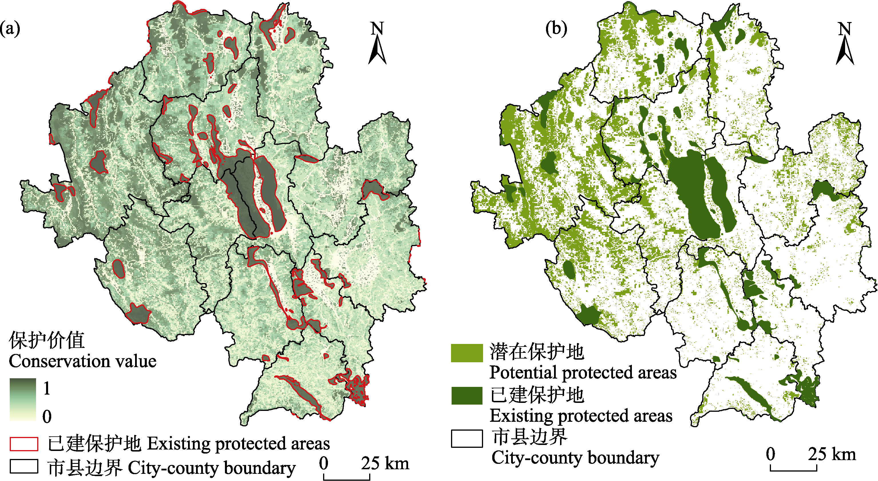
图4 云南省大理白族自治州保护价值(a)和30%保护目标下已建保护地与潜在保护地(b)分布
Fig. 4 Spatial distributions of the conservation value (a) and the existing and potential protected areas under 30% conservation target in Dali Bai Autonomous Prefecture, Yunnan Province (b)
| [1] |
Araújo MB, Alagador D, Naimi B, Neto D, Rozenfeld A (2025) Towards a climate-resilient conservation network in Portugal. Biological Conservation, 308, 111249.
DOI URL |
| [2] | Bai HF, Liu XD, Niu SK, He YD (2021) Construction of forest fire prediction model based on Bayesian model averaging method: Taking Dali Prefecture, Yunnan Province of southwestern China as an example. Journal of Beijing Forestry University, 43(5), 44-52. (in Chinese with English abstract) |
| [ 白海峰, 刘晓东, 牛树奎, 何亚东 (2021) 基于贝叶斯模型平均法的森林火灾预测模型构建研究——以云南省大理州为例. 北京林业大学学报, 43(5), 44-52.] | |
| [3] |
Brooks TM, Mittermeier RA, da Fonseca GAB, Gerlach J, Hoffmann M, Lamoreux JF, Mittermeier CG, Pilgrim JD, Rodrigues ASL (2006) Global biodiversity conservation priorities. Science, 313, 58-61.
DOI PMID |
| [4] |
Cao JS, Deng ZY, Huang ZH, Cui GF (2025) Identifying conservation priority areas of China: A methodological framework for ecosystem integrity and authenticity. Biological Conservation, 302, 110924.
DOI URL |
| [5] | Cao W, Huang L, Xiao T, Wu D (2019) Effects of human activities on the ecosystems of China’s national nature reserves. Acta Ecologica Sinica, 39, 1338-1350. (in Chinese with English abstract) |
| [ 曹巍, 黄麟, 肖桐, 吴丹 (2019) 人类活动对中国国家级自然保护区生态系统的影响. 生态学报, 39, 1338-1350.] | |
| [6] | Chen MX, Lu DD, Zhang H (2009) Comprehensive evaluation and the driving factors of China’s urbanization. Acta Geographica Sinica, 64, 387-398. (in Chinese with English abstract) |
| [ 陈明星, 陆大道, 张华 (2009) 中国城市化水平的综合测度及其动力因子分析. 地理学报, 64, 387-398.] | |
| [7] | Deléglise H, Justeau-Allaire D, Mulligan M, Espinoza JC, Isasi-Catalá E, Alvarez C, Condom T, Palomo I (2024) Integrating multi-objective optimization and ecological connectivity to strengthen Peru’s protected area system towards the 30*2030 target. Biological Conservation, 299, 110799. |
| [8] |
Diao YX, Wang JJ, Yang FL, Wu W, Zhou J, Wu RD (2021) Identifying optimized on-the-ground priority areas for species conservation in a global biodiversity hotspot. Journal of Environmental Management, 290, 112630.
DOI URL |
| [9] | Duan TL, Li N, Huang ZP, Li YP, Mu Y, Xiao W (2024) Progress of China’s national park construction and development prospects. Acta Ecologica Sinica, 44, 4964-4972. (in Chinese with English abstract) |
| [ 段廷璐, 李娜, 黄志旁, 李延鹏, 沐远, 肖文 (2024) 我国国家公园建设研究进展. 生态学报, 44, 4964-4972.] | |
| [10] | Feng ZX, Zhou J, Yang FL, Wu RD (2023) Systematic conservation planning by integrating ecosystem services and biodiversity. Acta Ecologica Sinica, 43, 522-533. (in Chinese with English abstract) |
| [ 封志雪, 周键, 杨飞龄, 武瑞东 (2023) 集成生态系统服务与生物多样性的系统保护规划. 生态学报, 43, 522-533.] | |
| [11] | Gan Y, Zhang JD, Yang HB, Li Y, Chen J (2025) Assessment of the effectiveness of China’s natural reserves in protecting forest landscape. Acta Ecologica Sinica, 45, 1549-1562. (in Chinese with English abstract) |
| [ 甘悦, 张晋东, 杨洪波, 李阳, 陈珺 (2025) 中国自然保护地的森林景观保护成效评估. 生态学报, 45, 1549-1562.] | |
| [12] | Guo ZL, Zhang YG, Liu WW, Zhang MY, Liu ZJ (2024) Distribution pattern and conservation priority areas of waterbird diversity in Hengshui Lake Nature Reserve, Hebei Province. Acta Ecologica Sinica, 44, 4009-4019. (in Chinese with English abstract) |
| [ 郭子良, 张余广, 刘魏魏, 张曼胤, 刘振杰 (2024) 河北衡水湖自然保护区水鸟多样性分布格局及其保护优先区. 生态学报, 44, 4009-4019.] | |
| [13] | Hu PJ, Wu RD (2017) Establishment of the regional-scale spatial database on nature reserves. e-Science Technology & Application, 8(3), 58-64. (in Chinese with English abstract) |
| [ 胡佩君, 武瑞东 (2017) 区域尺度自然保护区网络空间信息库构建. 科研信息化技术与应用, 8(3), 58-64.] | |
| [14] |
Langhammer PF, Bull JW, Bicknell JE, Oakley JL, Brown MH, Bruford MW, Butchart SHM, Carr JA, Church D, Cooney R, Cutajar S, Foden W, Foster MN, Gascon C, Geldmann J, Genovesi P, Hoffmann M, Howard-McCombe J, Lewis T, MacFarlane NBW, Melvin ZE, Merizalde RS, Morehouse MG, Pagad S, Polidoro B, Sechrest W, Segelbacher G, Smith KG, Steadman J, Strongin K, Williams J, Woodley S, Brooks TM (2024) The positive impact of conservation action. Science, 384, 453-458.
DOI PMID |
| [15] | Lehtomäki J, Moilanen A (2013) Methods and workflow for spatial conservation prioritization using Zonation. Environmental Modelling & Software, 47, 128-137. |
| [16] | Li HP, Xu H, Zhang C, Ou GL, Sun XL (2023) Analysis on temporal and spatial dynamic changes of biomass of Pinus yunnanensis natural forest in Dali Prefecture. Journal of Southwest Forestry University (Natural Sciences), 43(5), 118-126. (in Chinese with English abstract) |
| [ 李会朋, 胥辉, 张超, 欧光龙, 孙晓莉 (2023) 大理州云南松天然林生物量时空动态变化研究. 西南林业大学学报(自然科学), 43(5), 118-126.] | |
| [17] | Li YN, Wang S, Guan YD, Hu CP (2022) A preliminary plan for the integration and optimization of Dali natural protected area. Shaanxi Forest Science and Technology, (5), 100-104. (in Chinese with English abstract) |
| [ 李亚楠, 王生, 管亚东, 胡昌平 (2022) 大理州自然保护地整合优化初步方案. 陕西林业科技, (5), 100-104.] | |
| [18] |
Liu RX, Kong HL, Wang QX, Li Y (2025) Identify priority protected areas for biodiversity conservation adapting to future climate and land cover changes. Ecological Indicators, 170, 113068.
DOI URL |
| [19] |
Lin SW, Wu RD, Hua CL, Ma JZ, Wang WL, Yang FL, Wang JJ (2016) Identifying local-scale wilderness for on-ground conservation actions within a global biodiversity hotspot. Scientific Reports, 6, 25898.
DOI PMID |
| [20] |
Ma TH, Lü C, Lei GC (2019) The spatial overlapping analysis for China’s natural protected area and countermeasures for the optimization and integration of protected area system. Biodiversity Science, 27, 758-771. (in Chinese with English abstract)
DOI |
|
[ 马童慧, 吕偲, 雷光春 (2019) 中国自然保护地空间重叠分析与保护地体系优化整合对策. 生物多样性, 27, 758-771.]
DOI |
|
| [21] | Ma YM, Wu YM, Wu BJ (2015) Comprehensive evaluation of sustainable urban development of Yangtze River delta based on entropy method and quadrant method. Economic Geography, 35(6), 47-53. (in Chinese with English abstract) |
| [ 马艳梅, 吴玉鸣, 吴柏钧 (2015) 长三角地区城镇化可持续发展综合评价——基于熵值法和象限图法. 经济地理, 35(6), 47-53.] | |
| [22] |
Margules CR, Pressey RL (2000) Systematic conservation planning. Nature, 405, 243-253.
DOI |
| [23] |
McIntosh EJ, Pressey RL, Lloyd S, Smith RJ, Grenyer R (2017) The impact of systematic conservation planning. Annual Review of Environment and Resources, 42, 677-697.
DOI URL |
| [24] | Ouyang ZY, Du A, Xu WH (2020) Research on China’s protected area system classification. Acta Ecologica Sinica, 40, 7207-7215. (in Chinese with English abstract) |
| [ 欧阳志云, 杜傲, 徐卫华 (2020) 中国自然保护地体系分类研究. 生态学报, 40, 7207-7215.] | |
| [25] |
Pan YX, Tian Y, Wu Y, Fu MD (2025) A comprehensive approach for the spatial optimization of the biodiversity conservation network in the Qinling Mountains, China. Landscape Ecology, 40, 11.
DOI |
| [26] |
Ramel C, Rey PL, Fernandes R, Vincent C, Cardoso AR, Broennimann O, Pellissier L, Pradervand JN, Ursenbacher S, Schmidt BR, Guisan A (2020) Integrating ecosystem services within spatial biodiversity conservation prioritization in the Alps. Ecosystem Services, 45, 101186.
DOI URL |
| [27] |
Shannon CE (1948) A mathematical theory of communication. The Bell System Technical Journal, 27, 379-423.
DOI URL |
| [28] | Shen Y, Cheng H, Liu GH, Deng HB, Su XK (2024) Conservation gaps and priorities on the Qinghai-Tibetan Plateau based on biodiversity and ecosystem services. Acta Ecologica Sinica, 44, 4507-4516. (in Chinese with English abstract) |
| [ 申宇, 程浩, 刘国华, 邓红兵, 苏旭坤 (2024) 基于生物多样性和生态系统服务的青藏高原保护优先区和保护空缺识别. 生态学报, 44, 4507-4516.] | |
| [29] | Sun WC, Zhao YJ, Chen WH, Bai YF (2024) Current national nature reserves are insufficient to safeguard the long-term survival of birds and mammals in China. Communications Earth & Environment, 5, 304. |
| [30] |
Tao SQ, Yang FL, Hua CL, Wu RD (2024) Priority assessment for natural vegetation conservation in Yunnan Province by integrating threatened status and conservation value. Biodiversity Science, 32, 23324. (in Chinese with English abstract)
DOI URL |
|
[ 陶斯琦, 杨飞龄, 华朝朗, 武瑞东 (2024) 通过综合受威胁状态和保护价值评估云南省自然植被的保护优先性. 生物多样性, 32, 23324.]
DOI |
|
| [31] |
Vaz AS, Amorim F, Pereira P, Antunes S, Rebelo H, Oliveira NG (2021) Integrating conservation targets and ecosystem services in landscape spatial planning from Portugal. Landscape and Urban Planning, 215, 104213.
DOI URL |
| [32] | Wang FX, Mao AH, Li HL, Jia ML (2013) Quality measurement and regional difference of urbanization in Shandong Province based on the entropy method. Scientia Geographica Sinica, 33, 1323-1329. (in Chinese with English abstract) |
|
[ 王富喜, 毛爱华, 李赫龙, 贾明璐 (2013) 基于熵值法的山东省城镇化质量测度及空间差异分析. 地理科学, 33, 1323-1329.]
DOI |
|
| [33] |
Wang N, Du YY, Liang FY, Yi JW, Qian JL, Tu WN, Huang S, Luo PX (2023) Protected areas effectively resisted 33.8% of urban development pressures in China during 2000-2018. Applied Geography, 159, 103079.
DOI URL |
| [34] |
Wang XX, Wang XF, Tu Y, Yao WJ, Zhou JT, Jia ZX, Ma JH, Sun ZC (2024) Systematic conservation planning considering ecosystem services can optimize the conservation system in the Qinling-Daba Mountains. Journal of Environmental Management, 368, 122096.
DOI URL |
| [35] |
Wu RD, Hua CL, Yu GZ, Ma JZ, Yang FL, Wang JJ, Jin T, Long YC, Guo Y, Zhao HW (2020) Assessing protected area overlaps and performance to attain China’s new national park system. Biological Conservation, 241, 108382.
DOI URL |
| [36] | Wu RD, Long YC, Malanson GP, Garber PA, Zhang S, Li DQ, Zhao P, Wang LZ, Duo HR (2014) Optimized spatial priorities for biodiversity conservation in China: A systematic conservation planning perspective. PLoS ONE, 9, e103783. |
| [37] | Xiao J, Cui L, Li JQ (2016) Zonation-based conservation planning for multiple species in Minshan, China. Acta Ecologica Sinica, 36, 420-429. (in Chinese with English abstract) |
| [ 肖静, 崔莉, 李俊清 (2016) 基于Zonation的岷山山系多物种保护规划. 生态学报, 36, 420-429.] | |
| [38] |
Yang FL, Hu JM, Wu RD (2013) Identifying plant priority conservation areas based on the NPWP distribution in Yunnan, China. Acta Geographica Sinica, 68, 1538-1548. (in Chinese with English abstract)
DOI |
|
[ 杨飞龄, 胡金明, 武瑞东 (2013) 基于NPWP的云南植物保护优先区分析. 地理学报, 68, 1538-1548.]
DOI |
|
| [39] |
Yang FL, Wu RD, Jin T, Long YC, Zhao P, Yu Q, Wang LZ, Wang JJ, Zhao HW Guo Y (2019) Efficiency of unlocking or locking existing protected areas for identifying complementary areas for biodiversity conservation. Science of the Total Environment, 694, 133771.
DOI URL |
| [40] | Yang ZX, Chao ZH, Xu JH, Hua CL, Tao J, Yu Y, Luo HX, Li J, Yang JR (2020) Preliminary idea on integration of protected natural areas in Dali Bai Autonomous Prefecture. Forest Inventory and Planning, 45(6), 46-52, 164. (in Chinese with English abstract) |
| [ 杨忠兴, 晁增华, 徐吉洪, 华朝朗, 陶晶, 俞瑶, 罗怀秀, 李晋, 杨焌熔 (2020) 大理州自然保护地整合归并初步构想. 林业调查规划, 45(6), 46-52, 164.] | |
| [41] |
Yu CY, Zhang ZH, Jeppesen E, Gao Y, Liu YX, Liu YJ, Lu QL, Wang CX, Sun XM (2024) Assessment of the effectiveness of China’s protected areas in enhancing ecosystem services. Ecosystem Services, 65, 101588.
DOI URL |
| [42] | Zhang LB, Luo ZH, Mallon D, Li CW, Jiang ZG (2017) Biodiversity conservation status in China’s growing protected areas. Biological Conservation, 210, 89-100. |
| [43] |
Zhou J, Yang FL, Wang JJ, Wang YT, Zhang C, Feng ZX, Wu RD (2021) Identification and conservation assessment of priority conservation areas for terrestrial vertebrates in Yunnan. Chinese Journal of Ecology, 40, 2872-2882. (in Chinese with English abstract)
DOI |
| [ 周键, 杨飞龄, 王军军, 王一婷, 张晨, 封志雪, 武瑞东 (2021) 云南省陆栖脊椎动物保护优先区判识与保护状况评价. 生态学杂志, 40, 2872-2882.] | |
| [44] |
Zhou J, Zhong ZJ, Liu HY, Yang FL, Luo JY, Qin HN, Wu RD (2024) Identifying complementary conservation and restoration priority areas for plant species. Biological Conservation, 299, 110826.
DOI URL |
| [1] | 王也, 王茜璐, 关婧, 王迎. 《生物多样性公约》现行资金机制及其替代方案研究[J]. 生物多样性, 2026, 34(1): 25353-. |
| [2] | 杨方义, 靳彤, 申小莉, 张立, 杨彪. 生物多样性公益捐赠对中国生物多样性保护战略与行动计划(2023‒2030年)的贡献[J]. 生物多样性, 2026, 34(1): 25269-. |
| [3] | 吴春莹, Viorel D. Popescu, 季吟秋. 生物多样性评估挑战的层级占有率模型解决路径[J]. 生物多样性, 2026, 34(1): 25386-. |
| [4] | 邹怡. α多样性指数选择: 不等量采样下的模拟比较[J]. 生物多样性, 2026, 34(1): 25278-. |
| [5] | 韩群力. 关于联合国教科文组织人与生物圈计划及世界生物圈保护区网络未来优先行动的建议[J]. 生物多样性, 2025, 33(9): 25144-. |
| [6] | 李彬彬, 葛蕴丰, 吴舒尧, 华方圆, 米湘成, 曾玉红. 中国长江流域生态恢复回顾与展望[J]. 生物多样性, 2025, 33(9): 25291-. |
| [7] | 冯春婷, 吴晨, 孙熙晴, 王伟. 中国的世界生物圈保护区人与自然关系评估[J]. 生物多样性, 2025, 33(9): 25248-. |
| [8] | 武慧, 俞乐, 赵剑桥, 郑诗军, 刘涛, 戚文超, 赵强, 朱丽, 申小莉, 马克平. 世界生物圈保护区网络生态代表性与保护成效的南北差异[J]. 生物多样性, 2025, 33(9): 25267-. |
| [9] | 钱嘉宁. 履行就地保护义务的投资仲裁风险及应对[J]. 生物多样性, 2025, 33(7): 24333-. |
| [10] | 时永强, 单秀娟, 赵杰, 王一诺, 栾青杉, 卞晓东, 陈云龙, 金显仕. 1958-2020年黄河口及其邻近海域浮游动物群落组成及多样性演变[J]. 生物多样性, 2025, 33(7): 24437-. |
| [11] | 陈耀辉, 周梓华, 邱洪, 张敬怀. 广东省海岸带牡蛎礁的分布特征、主要威胁及保护建议[J]. 生物多样性, 2025, 33(7): 24414-. |
| [12] | 董雪云, 夏富才, 周繇, 张立秋, 何怀江, 刘冰, 姜润华, 王洪峰. 吉林省野生维管植物名录[J]. 生物多样性, 2025, 33(7): 25120-. |
| [13] | 赵富伟. 遗传资源数字序列信息多边机制的谈判进程及我国的对策[J]. 生物多样性, 2025, 33(6): 24559-. |
| [14] | 李云翱, 张文富, 赵桂刚, 杨春燕, 陈向清, 袁盛东, 曹敏, 蔡望, 杨洁. 空气环境DNA在陆生脊椎动物多样性监测上的应用: 以西双版纳20 ha森林动态样地为例[J]. 生物多样性, 2025, 33(6): 24318-. |
| [15] | 干靓, 刘巷序, 鲁雪茗, 岳星. 全球生物多样性热点地区中国大城市的保护政策与优化方向[J]. 生物多样性, 2025, 33(5): 24529-. |
| 阅读次数 | ||||||
|
全文 |
|
|||||
|
摘要 |
|
|||||
备案号:京ICP备16067583号-7
Copyright © 2026 版权所有 《生物多样性》编辑部
地址: 北京香山南辛村20号, 邮编:100093
电话: 010-62836137, 62836665 E-mail: biodiversity@ibcas.ac.cn
![]()