
生物多样性 ›› 2025, Vol. 33 ›› Issue (4): 24174. DOI: 10.17520/biods.2024174 cstr: 32101.14.biods.2024174
刘咏华1,2,3, 童光蓉4, 余航远4, 王宁宁1,2, 任海保1,2, 陈磊1,2,3, 马克平1,2,3( ), 米湘成1,2,*()(
 )
)
收稿日期:2024-05-09
接受日期:2024-06-28
出版日期:2025-04-20
发布日期:2024-07-18
通讯作者:
*E-mail: mixiangcheng@ibcas.ac.cn
基金资助:
Liu Yonghua1,2,3, Tong Guangrong4, Yu Hangyuan4, Wang Ningning1,2, Ren Haibao1,2, Chen Lei1,2,3, Ma Keping1,2,3(), Mi Xiangcheng1,2,*()()
Received:2024-05-09
Accepted:2024-06-28
Online:2025-04-20
Published:2024-07-18
Contact:
*E-mail: mixiangcheng@ibcas.ac.cn
Supported by:摘要: 国家公园内的植被生态系统具有典型性和国家代表性, 是国家公园的重点保护对象。为实现国家公园生态系统和生物多样性的保护管理目标, 有必要监测国家公园内植被的变化, 根据监测结果评估保护成效, 进而制定可持续管理战略。航空遥感是获取大面积植被信息的有效手段, 使得在大尺度上高效地监测国家公园的植被动态变化成为可能。本研究以钱江源-百山祖国家公园候选区钱江源园区(简称钱江源园区)全域共21,820个100 m × 100 m像元为研究对象, 基于机载激光雷达和高光谱的多源遥感数据, 结合2018年林业小班调查数据, 探究利用遥感数据获取的冠层特征与植被三维冠层结构和光谱特征的关系, 以分析利用航空遥感监测国家公园保护成效的潜在应用。结果表明: (1)钱江源园区冠层特征变化范围大, 不同区域冠层特征差异较大。(2)不同人为干扰程度的冠层特征差异显著, 结合冠层空间结构特征及光谱特征, 能够反映保护成效: 重度干扰的次生林或人工林冠层高度低、叶面积小, 垂直复杂度低, 低矮植被和稀疏植被占比大, 对光资源的利用效率低, 叶片衰老程度高; 中度干扰的次生落叶阔叶林和轻微或无干扰的常绿阔叶林老龄林均表现出冠层高度大、叶面积大且垂直复杂度较高的特征, 但老龄林所受压力小, 对光资源的利用效率高, 叶片衰老程度低。本研究结果可为国家公园中森林生态系统和生物多样性的保护和管理提供科学支撑。
刘咏华, 童光蓉, 余航远, 王宁宁, 任海保, 陈磊, 马克平, 米湘成 (2025) 钱江源-百山祖国家公园候选区钱江源园区冠层三维结构及光谱特征对人为干扰的响应. 生物多样性, 33, 24174. DOI: 10.17520/biods.2024174.
Liu Yonghua, Tong Guangrong, Yu Hangyuan, Wang Ningning, Ren Haibao, Chen Lei, Ma Keping, Mi Xiangcheng (2025) Responses of canopy three-dimensional structural and spectral characteristics to anthropogenic disturbance in the Qianjiangyuan section of the Qianjiangyuan- Baishanzu National Park candidate area. Biodiversity Science, 33, 24174. DOI: 10.17520/biods.2024174.
| 参数 Parameters | 值 Values |
|---|---|
| 飞行速度 Flight speed (km/h) | 250 |
| 飞行高度 Flight height (m) | 1,960 |
| 相对航高 Relative flight height (m) | 1,660 |
| 脉冲频率 Pulse repetition rate (kHz) | 700 |
| 视场角 Field angle of view | 58.52° |
| 扫描速率 Scanning rate (lps) | 246 |
| 扫描幅宽 Scanning width (m) | 1,860 |
| 点密度 Point density (points/m2) | > 4 |
| 旁向重叠度 Side overlap (%) | 20 |
表1 机载激光雷达系统的技术参数
Table 1 Technical parameters of airborne LiDAR system
| 参数 Parameters | 值 Values |
|---|---|
| 飞行速度 Flight speed (km/h) | 250 |
| 飞行高度 Flight height (m) | 1,960 |
| 相对航高 Relative flight height (m) | 1,660 |
| 脉冲频率 Pulse repetition rate (kHz) | 700 |
| 视场角 Field angle of view | 58.52° |
| 扫描速率 Scanning rate (lps) | 246 |
| 扫描幅宽 Scanning width (m) | 1,860 |
| 点密度 Point density (points/m2) | > 4 |
| 旁向重叠度 Side overlap (%) | 20 |
| 参数 Parameters | 值 Values |
|---|---|
| 光谱范围 Spectral range (nm) | 400-1,000 |
| 光谱分辨率 Spectral resolution (nm) | 8.8-9.7 |
| 视场角 Field angle of view | 37.7° |
| 瞬时视场角 Momentary field angle of view (mrad) | 0.646 |
| 焦距 Focal length (mm) | 18.5 |
| 空间分辨率 Spatial resolution (m) | 1 |
| 波段数 Number of bands | 64 |
| 空间像元数Number of spatial pixels | 1,024 |
| 光谱采样间隔 Spectral sampling interval (nm) | 9.2 |
| 数字分辨率 Digital number (bit) | 16 |
| 相对航高 Relative airspeed (m) | 1,000 |
| 旁向重叠度 Side overlap (%) | 20 |
表2 机载高光谱系统的技术参数
Table 2 Technical parameters of airborne hyperspectral system
| 参数 Parameters | 值 Values |
|---|---|
| 光谱范围 Spectral range (nm) | 400-1,000 |
| 光谱分辨率 Spectral resolution (nm) | 8.8-9.7 |
| 视场角 Field angle of view | 37.7° |
| 瞬时视场角 Momentary field angle of view (mrad) | 0.646 |
| 焦距 Focal length (mm) | 18.5 |
| 空间分辨率 Spatial resolution (m) | 1 |
| 波段数 Number of bands | 64 |
| 空间像元数Number of spatial pixels | 1,024 |
| 光谱采样间隔 Spectral sampling interval (nm) | 9.2 |
| 数字分辨率 Digital number (bit) | 16 |
| 相对航高 Relative airspeed (m) | 1,000 |
| 旁向重叠度 Side overlap (%) | 20 |
| 植被指数 Vegetation indices | 计算公式 Formulas | 参考文献 Reference |
|---|---|---|
| 归一化植被指数 Normalized difference vegetation index (NDVI) | Rouse et al, | |
| 红边归一化植被指数 Red-edge normalized difference vegetation index (NDVI705) | Elvidge & Chen, | |
| 光化学反射指数 Photochemical reflectance index (PRI) | Gamon et al, | |
| 植被衰减指数 Plant senescence reflectance index (PSRI) | Merzlyak et al, |
表3 高光谱植被指数
Table 3 Hyperspectral vegetation indices
| 植被指数 Vegetation indices | 计算公式 Formulas | 参考文献 Reference |
|---|---|---|
| 归一化植被指数 Normalized difference vegetation index (NDVI) | Rouse et al, | |
| 红边归一化植被指数 Red-edge normalized difference vegetation index (NDVI705) | Elvidge & Chen, | |
| 光化学反射指数 Photochemical reflectance index (PRI) | Gamon et al, | |
| 植被衰减指数 Plant senescence reflectance index (PSRI) | Merzlyak et al, |
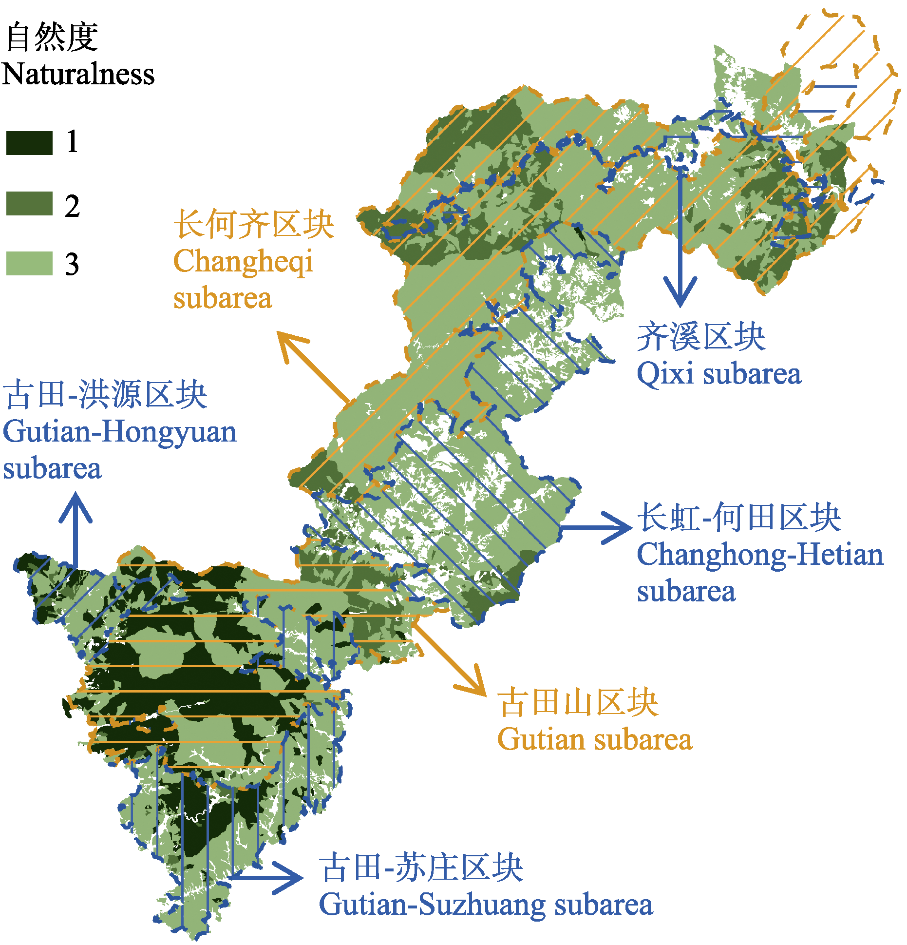
图1 钱江源-百山祖国家公园候选区钱江源园区主要功能区块(黄色为核心保护区, 蓝色为一般控制区)及2018年林业小班调查自然度。不同自然度的含义为: 1: 老龄林或受人为影响很小的地带性顶极群落的植被(常绿阔叶林); 2: 有明显人为干扰的天然植被或处于演替中期或后期的次生群落(落叶阔叶林、灌木林等); 3: 处于人为干扰严重的次生植被阶段或天然植被几乎破坏殆尽, 难以恢复的逆行演替后期天然针叶林(人工林)。
Fig. 1 Functional divisions and their main subareas (the yellow area is the core protection area, and the blue area is the general control area) in Qianjiangyuan section of the Qianjiangyuan-Baishanzu National Park candidate area, and naturalness of the 2018 subcompartment survey of the section. Meanings of different naturalness: 1, Zonal climax forests in pristine condition or with slight anthropogenic disturbances (broad-leaved evergreen forests); 2, Anthropogenically disturbed natural forests or secondary forests in the middle or late successional stages with obvious anthropogenic disturbances (deciduous broad-leaved forests, shrub forests, etc.); 3, Heavily disturbed or degraded coniferous forests in a highly fragmented secondary forests or plantation forests).
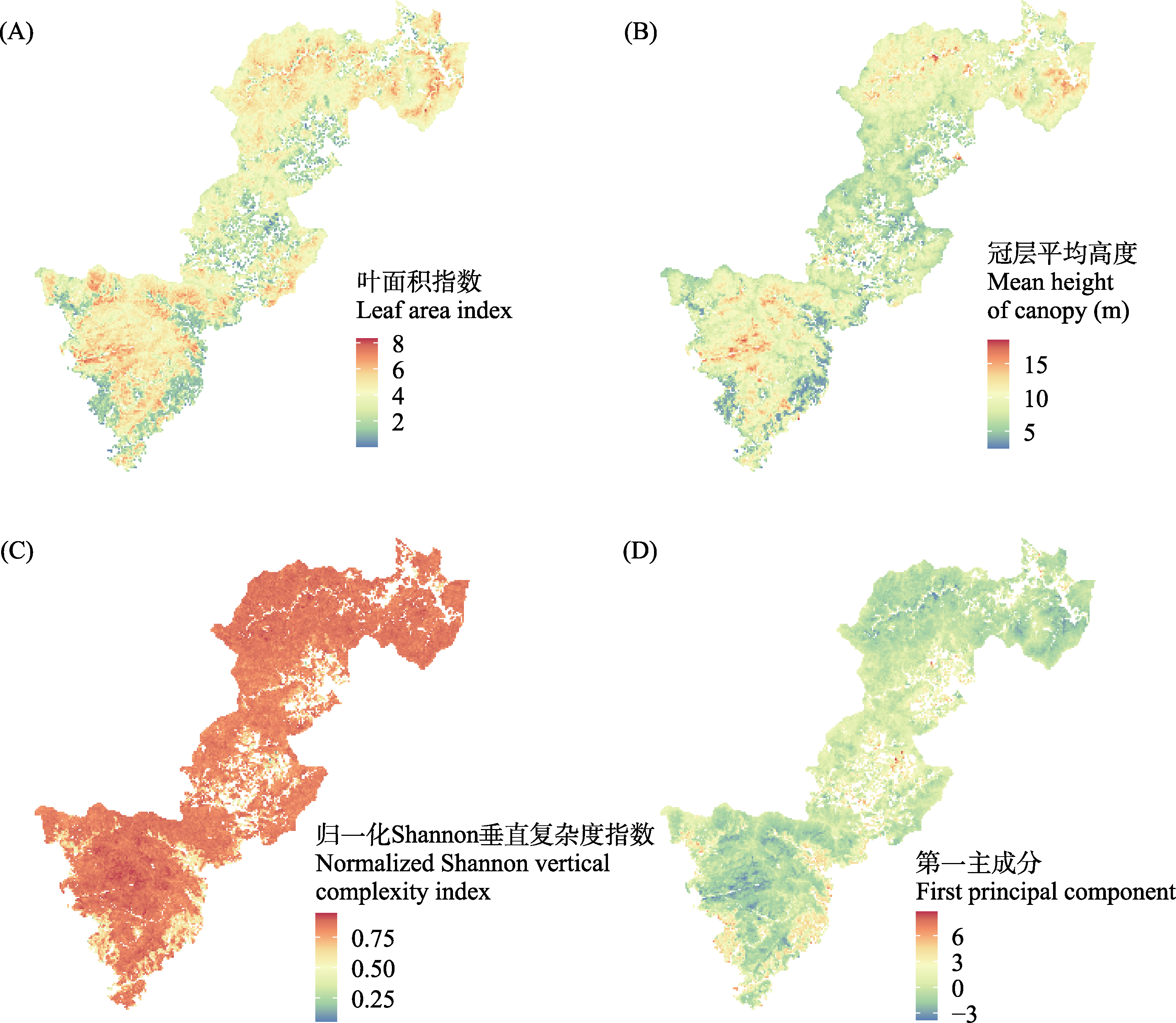
图2 钱江源-百山祖国家公园候选区钱江源园区冠层三维结构特征的空间分布格局。(A)叶面积指数; (B)冠层平均高度; (C)归一化Shannon垂直复杂度指数; (D)第一主成分。
Fig. 2 Spatial patterns of canopy three-dimensional structural characteristics in Qianjiangyuan section of the Qianjiangyuan-Baishanzu National Park candidate area. (A) Leaf area index; (B) Mean height of canopy; (C) Normalized Shannon vertical complexity index; (D) First principal component.
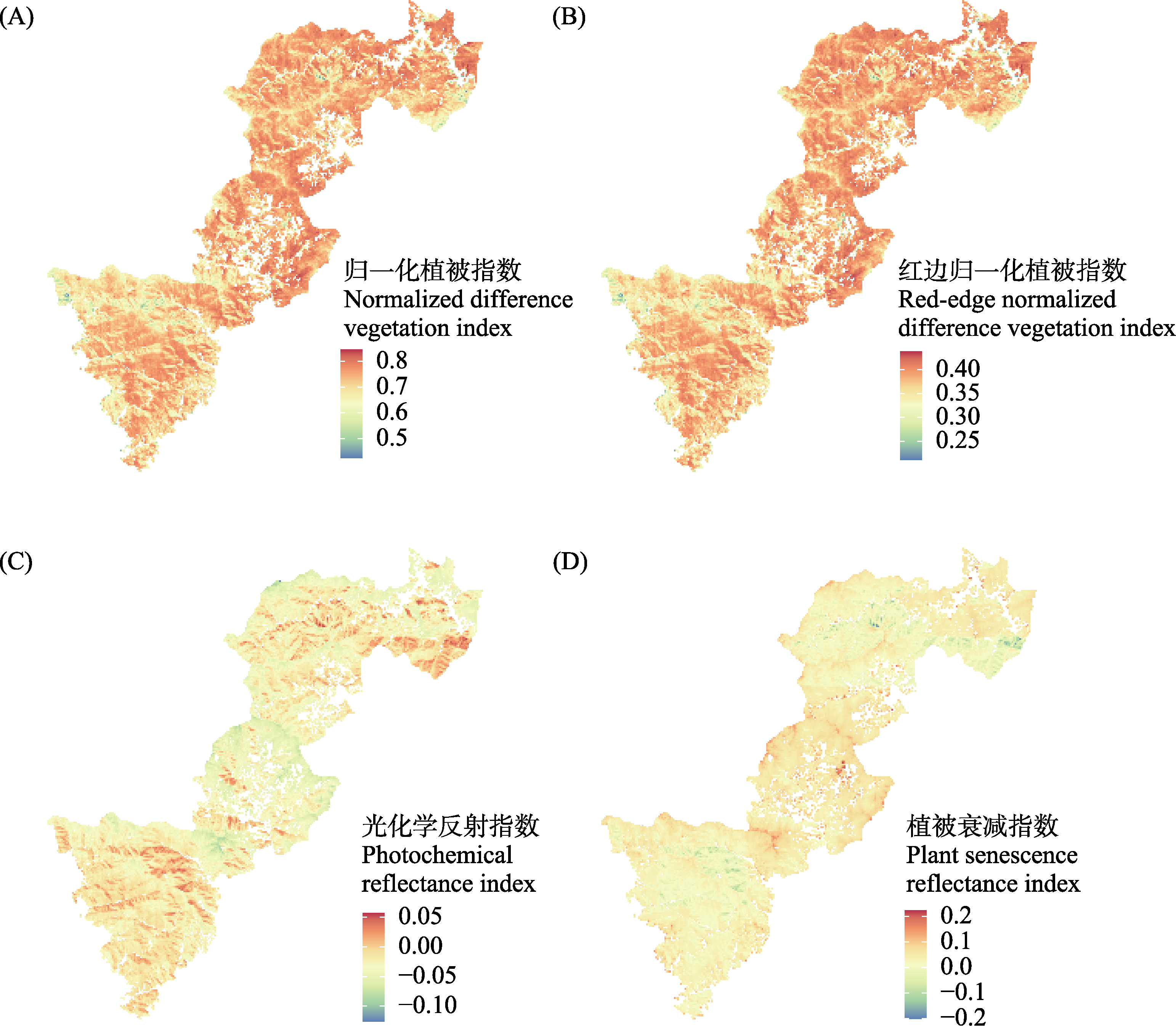
图3 钱江源-百山祖国家公园候选区钱江源园区冠层光谱特征的空间分布格局。(A)归一化植被指数; (B)红边归一化植被指数; (C)光化学反射指数; (D)植被衰减指数。
Fig. 3 Spatial patterns of canopy spectral characteristics in Qianjiangyuan section of the Qianjiangyuan-Baishanzu National Park candidate area. (A) Normalized difference vegetation index; (B) Red-edge normalized difference vegetation index; (C) Photochemical reflectance index; (D) Plant senescence reflectance index.
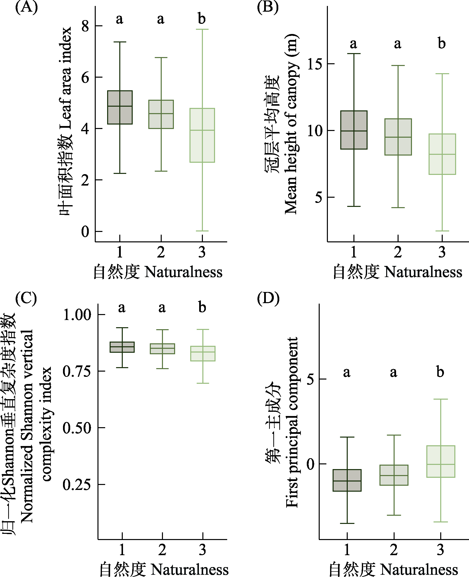
图4 钱江源-百山祖国家公园候选区钱江源园区不同自然度间冠层三维结构特征的差异。(A)叶面积指数; (B)冠层平均高度; (C)归一化Shannon垂直复杂度指数; (D)第一主成分。不同字母表示在P < 0.001水平上差异显著。
Fig. 4 Differences in canopy three-dimensional structural characteristics among different degrees of naturalness in Qianjiangyuan section of the Qianjiangyuan-Baishanzu National Park candidate area. (A) Leaf area index; (B) Mean height of canopy; (C) Normalized Shannon vertical complexity index; (D) First principal component. Different letters indicate significant differences at P < 0.001.
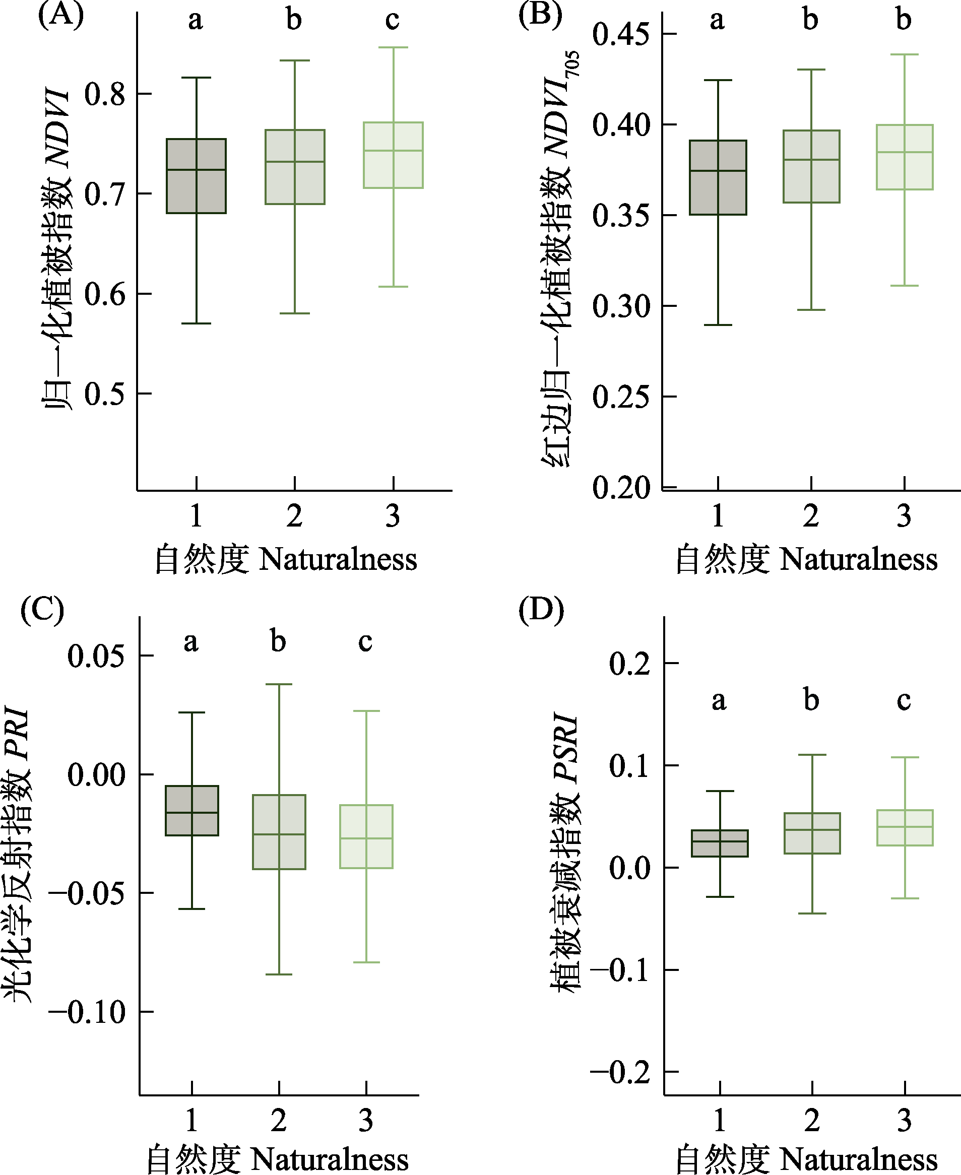
图5 钱江源-百山祖国家公园候选区钱江源园区不同自然度间冠层光谱特征的差异。(A)归一化植被指数; (B)红边归一化植被指数; (C)光化学反射指数; (D)植被衰减指数。不同字母代表至少在P < 0.01水平上存在差异显著。
Fig. 5 Differences in canopy spectral characteristics among different degrees of naturalness in Qianjiangyuan section of the Qianjiangyuan-Baishanzu National Park candidate area. (A) Normalized difference vegetation index; (B) Red-edge normalized difference vegetation index; (C) Photochemical reflectance index; (D) Plant senescence reflectance index. Different letters indicate significant differences at least at P < 0.01.
| [1] | Ali A (2019) Forest stand structure and functioning: Current knowledge and future challenges. Ecological Indicators, 98, 665-677. |
| [2] | Aponte C, Kasel S, Nitschke CR, Tanase MA, Vickers H, Parker L, Fedrigo M, Kohout M, Ruiz-Benito P, Zavala MA, Bennett LT (2020) Structural diversity underpins carbon storage in Australian temperate forests. Global Ecology and Biogeography, 29, 789-802. |
| [3] | Atkins JW, Costanza J, Dahlin KM, Dannenberg MP, Elmore AJ, Fitzpatrick MC, Hakkenberg CR, Hardiman BS, Kamoske A, LaRue EA, Silva CA, Stovall AEL, Tielens EK (2023) Scale dependency of LiDAR-derived forest structural diversity. Methods in Ecology and Evolution, 14, 708-723. |
| [4] | Barrette M, Dumais D, Auger I, Boucher Y, Bouchard M, Bouliane J (2020) Naturalness assessment performed using forestry maps to validate forest management sustainability. Ecological Indicators, 119, 106832. |
| [5] | Bisht S, Bargali SS, Bargali K, Rawat GS, Rawat YS, Fartyal A (2022) Influence of anthropogenic activities on forest carbon stocks—A case study from Gori Valley, Western Himalaya. Sustainability, 14, 16918. |
| [6] |
Blackburn RC, Buscaglia R, Sánchez Meador AJ(2021) Mixtures of airborne LiDAR-based approaches improve predictions of forest structure. Canadian Journal of Forest Research, 51, 1106-1116.
DOI |
| [7] | Chen GZ, Huang Y, Zhao XW, Tian MR (2022) Research on forest canopy height inversion based on GEDI, Sentinel-2 and DJI-L1 data. Geomatics & Spatial Information Technology, 45(S1), 235-238. (in Chinese with English abstract) |
| [陈贵珍, 黄杨, 赵晓伟, 田梦然 (2022) 基于GEDI、Sentinel-2和机载激光雷达的森林冠层高度反演研究. 测绘与空间地理信息, 45(S1), 235-238.] | |
| [8] |
Chen SW, Ren HB, Tong GR, Wang NN, Lan WC, Xue JH, Mi XC (2023) Spatial patterns in woody species diversity in the Qianjiangyuan National Park. Biodiversity Science, 31, 22587. (in Chinese with English abstract)
DOI |
|
[陈声文, 任海保, 童光蓉, 王宁宁, 蓝文超, 薛建华, 米湘成 (2023) 钱江源国家公园木本植物物种多样性空间分布格局. 生物多样性, 31, 22587.]
DOI |
|
| [9] | Chen XN, Li QW, Yu JP, Yu SH, Li S, Cao MC (2022) Habitat suitability assessment of Syrmaticus ellioti in the Qiangjiangyuan National Park. Ecology and Environmental Sciences, 31, 1832-1839. (in Chinese with English abstract) |
|
[陈小南, 李琼雯, 余建平, 余顺海, 李双, 曹铭昌 (2022) 钱江源国家公园白颈长尾雉生境适宜性评价研究. 生态环境学报, 31, 1832-1839.]
DOI |
|
| [10] | Stark SC, Shao G, Schietti J, Nelson BW, Silva CA, Gorgens EB, Valbuena R, Papa DA, Brancalion PHS (2019) Optimizing the remote detection of tropical rainforest structure with airborne LiDAR: Leaf area profile sensitivity to pulse density and spatial sampling. Remote Sensing, 11, 92. |
| [11] | de Groot RS, Wilson MA, Boumans RMJ (2002) A typology for the classification, description and valuation of ecosystem functions, goods and services. Ecological Economics, 41, 393-408. |
| [12] | Dubayah R, Blair JB, Goetz S, Fatoyinbo L, Hansen M, Healey S, Hofton M, Hurtt G, Kellner J, Luthcke S, Armston J, Tang H, Duncanson L, Hancock S, Jantz P, Marselis S, Patterson PL, Qi WL, Silva C (2020) The global ecosystem dynamics investigation: High-resolution laser ranging of the Earth’s forests and topography. Science of Remote Sensing, 1, 100002. |
| [13] | Elvidge CD, Chen Z (1995) Comparison of broad-band and narrow-band red and near-infrared vegetation indices. Remote Sensing of Environment, 54, 38-48. |
| [14] | Evangelides C, Nobajas A (2020) Red-edge normalized difference vegetation index (NDVI705) from Sentinel-2 imagery to assess post-fire regeneration. Remote Sensing Applications: Society and Environment, 17, 100283. |
| [15] | Fernández-Manso A, Fernández-Manso O, Quintano C (2016) Sentinel-2A red-edge spectral indices suitability for discriminating burn severity. International Journal of Applied Earth Observation and Geoinformation, 50, 170-175. |
| [16] |
Fischer R, Knapp N, Bohn F, Shugart HH, Huth A (2019) The relevance of forest structure for biomass and productivity in temperate forests: New perspectives for remote sensing. Surveys in Geophysics, 40, 709-734.
DOI |
| [17] | Gairola S, Rawal RS, Todaria NP (2015) Effect of anthropogenic disturbance on vegetation characteristics of sub-alpine forests in and around Valley of Flowers National Park, a world heritage site of India. Tropical Ecology, 56, 357-365. |
| [18] | Galia Selaya N, Oomen RJ, Netten JJC, Werger MJA, Anten NPR (2008) Biomass allocation and leaf life span in relation to light interception by tropical forest plants during the first years of secondary succession. Journal of Ecology, 96, 1211-1221. |
| [19] |
Gamon JA, Serrano L, Surfus JS (1997) The photochemical reflectance index: An optical indicator of photosynthetic radiation-use efficiency across species, functional types, and nutrient levels. Oecologia, 112, 492-501.
DOI PMID |
| [20] | Gogoi A, Sahoo UK (2018) Impact of anthropogenic disturbance on species diversity and vegetation structure of a lowland tropical rainforest of eastern Himalaya, India. Journal of Mountain Science, 15, 2453-2465. |
| [21] | Guo QH, Su YJ, Hu TY, Liu J (2018) LiDAR Principles, Processing and Applications in Forest Ecology. Higher Education Press, Beijing. (in Chinese) |
| [郭庆华, 苏艳军, 胡天宇, 刘瑾 (2018) 激光雷达森林生态应用——理论、方法和实例. 高等教育出版社, 北京.] | |
| [22] | Ham J, Chen Y, Crawford MM, Ghosh J (2005) Investigation of the random forest framework for classification of hyperspectral data. IEEE Transactions on Geoscience and Remote Sensing, 43, 492-501. |
| [23] | Han T, Ren H, Wang J, Lu H, Song G, Chazdon RL (2020) Variations of leaf eco-physiological traits in relation to environmental factors during forest succession. Ecological Indicators, 117, 106511. |
| [24] | Haq SM, Calixto ES, Rashid I, Khuroo AA (2021) Human-driven disturbances change the vegetation characteristics of temperate forest stands: A case study from Pir Panchal Mountain range in Kashmir Himalaya. Trees, Forests and People, 6, 100134. |
| [25] | Hardiman BS, Gough CM, Halperin A, Hofmeister KL, Nave LE, Bohrer G, Curtis PS (2013) Maintaining high rates of carbon storage in old forests: A mechanism linking canopy structure to forest function. Forest Ecology and Management, 298, 111-119. |
| [26] | Harding DJ, Lefsky MA, Parker GG, Blair JB (2001) Laser altimeter canopy height profiles: Methods and validation for closed-canopy, broadleaf forests. Remote Sensing of Environment, 76, 283-297. |
| [27] | Hijmans RJ (2023) terra: Spatial Data Analysis. https://CRAN.R-project.org/package=terra. (accessed on 2024-04-17) |
| [28] | Li LC, Zhou GS (2020) Response of forest vegetation to scenic activities in Wuyishan National Park. Acta Ecologica Sinica, 40, 7267-7276. (in Chinese with English abstract) |
| [李丽纯, 周广胜 (2020) 武夷山国家公园森林植被对景区活动的响应. 生态学报, 40, 7267-7276.] | |
| [29] | Li YC, Li ZX, Zhang XP, Yang AL, Gui J, Xue J (2023) Spatial and temporal changes in vegetation cover and response to human activities in Qilian Mountain National Park. Acta Ecologica Sinica, 43, 219-233. (in Chinese with English abstract) |
| [李玉辰, 李宗省, 张小平, 杨安乐, 桂娟, 薛健 (2023) 祁连山国家公园植被时空变化及其对人类活动的响应. 生态学报, 43, 219-233.] | |
| [30] | Liu H, Gu LJ, Ren RZ (2021) Research progress of forest parameter acquisition based on UAV remote sensing technology. Remote Sensing Technology and Application, 36, 489-501. (in Chinese with English abstract) |
|
[刘鹤, 顾玲嘉, 任瑞治 (2021) 基于无人机遥感技术的森林参数获取研究进展. 遥感技术与应用, 36, 489-501.]
DOI |
|
| [31] | Liu XZ, Ma S, Lu YC (2015) Research of forest naturalness assessment. Journal of Southwest Forestry University, 35, 99-105. (in Chinese with English abstract) |
| [刘宪钊, 马帅, 陆元昌 (2015) 森林自然度评价研究. 西南林业大学学报, 35, 99-105.] | |
| [32] | Malik ZA, Pandey R, Bhatt AB (2016) Anthropogenic disturbances and their impact on vegetation in Western Himalaya, India. Journal of Mountain Science, 13, 69-82. |
| [33] |
Matsuo T, Martínez-Ramos M, Bongers F, van der Sande MT, Poorter L (2021) Forest structure drives changes in light heterogeneity during tropical secondary forest succession. Journal of Ecology, 109, 2871-2884.
DOI PMID |
| [34] | Merzlyak MN, Gitelson AA, Chivkunova OB, Rakitin VY (1999) Non-destructive optical detection of pigment changes during leaf senescence and fruit ripening. Physiologia Plantarum, 106, 135-141. |
| [35] |
Moravčík M, Sarvašová Z, Merganič J, Schwarz M (2010) Forest naturalness: Criterion for decision support in designation and management of protected forest areas. Environmental Management, 46, 908-919.
DOI PMID |
| [36] | Narine LL, Popescu SC, Malambo L (2023) A methodological framework for mapping canopy cover using ICESat-2 in the Southern USA. Remote Sensing, 15, 1548. |
| [37] |
Ozanne CMP, Anhuf D, Boulter SL, Keller M, Kitching RL, Körner C, Meinzer FC, Mitchell AW, Nakashizuka T, Silva Dias PL, Stork NE, Wright SJ, Yoshimura M (2003) Biodiversity meets the atmosphere: A global view of forest canopies. Science, 301, 183-186.
DOI PMID |
| [38] | Piao SL, Wang XH, Park T, Chen C, Lian X, He Y, Bjerke JW, Chen AP, Ciais P, Tømmervik H, Nemani RR, Myneni RB (2020) Characteristics, drivers and feedbacks of global greening. Nature Reviews Earth & Environment, 1, 14-27. |
| [39] | Pinheiro J, Bates D, R Core Team(2023) nlme: Linear and Nonlinear Mixed Effects Models. https://CRAN.R-project.org/package=nlme. (accessed on 2024-04-17) |
| [40] | Prăvălie R, Sîrodoev I, Nita IA, Patriche C, Dumitraşcu M, Roşca B, Tişcovschi A, Bandoc G, Săvulescu I, Mănoiu V, Birsan MV (2022) NDVI-based ecological dynamics of forest vegetation and its relationship to climate change in Romania during 1987-2018. Ecological Indicators, 136, 108629. |
| [41] |
Ren SL, Chen XQ, An S (2017) Assessing plant senescence reflectance index-retrieved vegetation phenology and its spatiotemporal response to climate change in the Inner Mongolian Grassland. International Journal of Biometeorology, 61, 601-612.
DOI PMID |
| [42] | Roberts DA, Ustin SL, Ogunjemiyo S, Greenberg J, Dobrowski SZ, Chen JQ, Hinckley TM (2004) Spectral and structural measures of northwest forest vegetation at leaf to landscape scales. Ecosystems, 7, 545-562. |
| [43] | Rouse JW, Haas RH, Schell JA, Deering DW (1973) Monitoring vegetation systems in the great plains with ERTS. In: Third ERTS Symposium (ed NASA), pp. 309-317. NASA SP-351, NASA, Washington, DC. |
| [44] | Roussel JR, Auty D, Coops NC, Tompalski P, Goodbody TRH, Meador AS, Bourdon JF, de Boissieu F, Achim A (2020) lidR: An R package for analysis of airborne laser scanning (ALS) data. Remote Sensing of Environment, 251, 112061. |
| [45] |
Ruiz-Jaen MC, Potvin C (2011) Can we predict carbon stocks in tropical ecosystems from tree diversity? Comparing species and functional diversity in a plantation and a natural forest. New Phytologist, 189, 978-987.
DOI PMID |
| [46] | Shannon CE (1948) A mathematical theory of communication. The Bell System Technical Journal, 27, 379-423. |
| [47] | Thenkabail PS, Lyon JG, Huete A (2018) Hyperspectral Indices and Image Classifications for Agriculture and Vegetation. CRC Press, Boca Raton. |
| [48] | Wang C, Jia D, Lei S, Numata I, Tian L (2023) Accuracy assessment and impact factor analysis of GEDI leaf area index product in temperate forest. Remote Sensing, 15, 1535. |
| [49] | Wang JJ, Lan PT, Tao C, Jin Y (2023) Changes of landscape pattern in Qianjiangyuan National Park. Journal of Zhejiang Forestry Science and Technology, 43(1), 77-81. (in Chinese with English abstract) |
| [汪家军, 兰朋涛, 陶聪, 金艳 (2023) 钱江源国家公园景观格局变化探析. 浙江林业科技, 43(1), 77-81.] | |
| [50] | Wang Q, Adiku S, Tenhunen J, Granier A (2005) On the relationship of NDVI with leaf area index in a deciduous forest site. Remote Sensing of Environment, 94, 244-255. |
| [51] | Winter S (2012) Forest naturalness assessment as a component of biodiversity monitoring and conservation management. Forestry, 85, 293-304. |
| [52] | Wu YL, Li JZ, Yang YP, Zhou ZX (2010) Research advances in assessment of forest naturalness. Chinese Journal of Ecology, 29, 2065-2071. (in Chinese with English abstract) |
| [吴银莲, 李景中, 杨玉萍, 周志翔 (2010) 森林自然度评价研究进展. 生态学杂志, 29, 2065-2071.] | |
| [53] | Yi X, Wang N, Ren H, Yu J, Hu T, Su Y, Mi XC, Guo Q, Ma KP (2022) From canopy complementarity to asymmetric competition: The negative relationship between structural diversity and productivity during succession. Journal of Ecology, 110, 457-465. |
| [54] | Yu MJ, Hu ZH, Yu JP, Ding BY, Fang T (2001) Forest vegetation types in Gutianshan Natural Reserve in Zhejiang. Journal of Zhejiang University (Agriculture and Life Sciences), 27, 375-380. (in Chinese with English abstract) |
| [于明坚, 胡正华, 余建平, 丁炳扬, 方腾 (2001) 浙江古田山自然保护区森林植被类型. 浙江大学学报(农业与生命科学版), 27, 375-380.] | |
| [55] | Yue CY, Zheng YC, Xing YQ, Pang Y, Li SM, Cai LT, He HY (2020) Technical and application development study of space-borne LiDAR in forestry remote sensing. Infrared and Laser Engineering, 49(11), 105-114. (in Chinese with English abstract) |
| [岳春宇, 郑永超, 邢艳秋, 庞勇, 李世明, 蔡龙涛, 何红艳 (2020) 星载激光遥感林业应用发展研究. 红外与激光工程, 49(11), 105-114.] | |
| [56] | Zeng Y, Hao D, Park T, Zhu P, Huete A, Myneni R, Knyazikhin Y, Qi J, Nemani RR, Li F, Huang J, Gao Y, Li B, Ji F, Köhler P, Frankenberg C, Berry JA, Chen M (2023) Structural complexity biases vegetation greenness measures. Nature Ecology and Evolution, 7, 1790-1798. |
| [57] | Zhang B (2017) Current status and future prospects of remote sensing. Bulletin of Chinese Academy of Sciences, 32, 774-784. (in Chinese with English abstract) |
| [张兵 (2017) 当代遥感科技发展的现状与未来展望. 中国科学院院刊, 32, 774-784.] | |
| [58] | Zhang B, Xu G, Jiao L, Liu J, Dong T, Li Z, Liu X, Liu Y (2019) The scale effects of the spatial autocorrelation measurement: Aggregation level and spatial resolution. International Journal of Geographical Information Science, 33, 945-966. |
| [59] |
Zhang Q, Zhang TJ, Chow WS, Xie X, Chen YJ, Peng CL (2015) Photosynthetic characteristics and light energy conversions under different light environments in five tree species occupying dominant status at different stages of subtropical forest succession. Functional Plant Biology, 42, 609-619.
DOI PMID |
| [1] | 谢冰, 杨海涛, 曹吉鑫, 李进宇, 王茂良, 张微, 李建强, 徐基良. 应用激光雷达技术探究北京地区乌鸦夜栖地选择机制[J]. 生物多样性, 2026, 34(5): 26004-. |
| [2] | 黄语卓, 王梓潆, 周伟龙, 莫佳瑶, 张敏华, 郝春晖, 兰荣光, 叶沛阳, 刘宇. 浙江省百山祖25 ha亚热带森林动态监测样地木本植物叶片虫食强度分布格局及其影响因素[J]. 生物多样性, 2026, 34(4): 25406-. |
| [3] | 白梓彤, 王成, 齐志勇. 北京中心城区公园中生物声对植被三维结构的响应[J]. 生物多样性, 2026, 34(4): 25218-. |
| [4] | 黄莉, 刘志发, 龚粤宁, 李步杭, 张健. 广东南岭16个1 ha森林动态监测样地植物群落组成与结构[J]. 生物多样性, 2026, 34(3): 25357-. |
| [5] | 袁林溪, 王美震, 张利祥, 李彭, 张永生, 蒋学龙, 管振华. 人类活动对高黎贡白眉长臂猿栖息地乔木多样性及潜在食物资源的影响[J]. 生物多样性, 2026, 34(2): 25271-. |
| [6] | 柴恩平, 葛苏婷, 王锡茂, 杨州, 向昭宜, 张美惠, 李漫淑, 沈瑶, 斯幸峰. 基于高频监测研究人为干扰对城市夜鹭巢址分布动态及繁殖成功的影响[J]. 生物多样性, 2025, 33(9): 25025-. |
| [7] | 吴晓晴, 张美惠, 葛苏婷, 李漫淑, 达良俊, 宋坤, 沈国春, 张健. 上海近自然林重建过程中木本植物物种多样性与地上生物量的时空动态: 以闵行区生态岛为例[J]. 生物多样性, 2025, 33(5): 24444-. |
| [8] | 袁敬毅, 张旭, 田镇朋, 王梓柘, 高永萍, 姚迪昭, 关宏灿, 李文楷, 刘婧, 张宏, 马勤. 结合无人机高分辨率可见光影像和激光雷达点云的城市植物群落树种组成和数量特征提取方法对比[J]. 生物多样性, 2025, 33(4): 24237-. |
| [9] | 张瑶, 孙君瑶, 李伟. 雅鲁藏布江流域不同海拔梯度下消落区植被NDVI的时空变化趋势及驱动因素[J]. 生物多样性, 2024, 32(5): 23432-. |
| [10] | 艾妍雨, 胡海霞, 沈婷, 莫雨轩, 杞金华, 宋亮. 附生维管植物多样性及其与宿主特征的相关性: 以哀牢山中山湿性常绿阔叶林为例[J]. 生物多样性, 2024, 32(5): 24072-. |
| [11] | 冯嘉谊, 练琚愉, 冯瑜莙, 张东旭, 曹洪麟, 叶万辉. 鼎湖山南亚热带常绿阔叶林群落垂直分层对群落结构及功能的影响[J]. 生物多样性, 2024, 32(12): 24306-. |
| [12] | 徐凯伦, 陈小荣, 张敏华, 于婉婉, 吴素美, 朱志成, 陈定云, 兰荣光, 董舒, 刘宇. 演替和地形共同影响浙江百山祖森林群落的性系统多样性[J]. 生物多样性, 2024, 32(12): 24338-. |
| [13] | 楼晨阳, 任海保, 陈小南, 米湘成, 童冉, 朱念福, 陈磊, 吴统贵, 申小莉. 钱江源国家公园森林群落的物种多样性、结构多样性及其对黑麂出现概率的影响[J]. 生物多样性, 2023, 31(6): 22518-. |
| [14] | 陈星, 涂淑雯, 戴尊, 高爽, 王幼芳, 邢诗晨, 魏博嘉, 唐录艳, 师瑞萍, 王晓蕊, 刘永英, 赵东平, 唐霞, 姚雪, 赵明水, 吴晗星, 祁祥斌, 张健, 李敏, 王健. 浙江天目山国家级自然保护区苔藓植物多样性[J]. 生物多样性, 2023, 31(4): 22649-. |
| [15] | 薛玉洁, 程安鹏, 李珊, 刘晓娟, 李景文. 亚热带森林中环境和物种多样性对灌木存活的影响[J]. 生物多样性, 2023, 31(3): 22443-. |
| 阅读次数 | ||||||
|
全文 |
|
|||||
|
摘要 |
|
|||||
备案号:京ICP备16067583号-7
Copyright © 2026 版权所有 《生物多样性》编辑部
地址: 北京香山南辛村20号, 邮编:100093
电话: 010-62836137, 62836665 E-mail: biodiversity@ibcas.ac.cn
![]()