
生物多样性 ›› 2020, Vol. 28 ›› Issue (9): 1049-1058. DOI: 10.17520/biods.2020038 cstr: 32101.14.biods.2020038
所属专题: 青藏高原生物多样性与生态安全
李晟1,*( ), William J. McShea2, 王大军1, 申小莉3, 卜红亮1, 官天培4, 王放5, 古晓东6, 张晓峰7, 廖灏泓8
收稿日期:2020-02-09
接受日期:2020-07-13
出版日期:2020-09-20
发布日期:2020-07-20
通讯作者:
李晟
作者简介:*E-mail: shengli@pku.edu.cn基金资助:
Sheng Li1,*(), William J. McShea2, Dajun Wang1, Xiaoli Shen3, Hongliang Bu1, Tianpei Guan4, Fang Wang5, Xiaodong Gu6, Xiaofeng Zhang7, Haohong Liao8
Received:2020-02-09
Accepted:2020-07-13
Online:2020-09-20
Published:2020-07-20
Contact:
Sheng Li
摘要:
中国西南山地是全球生物多样性热点区。西南山地红外相机监测网络是我国生物多样性监测的区域性红外相机网络之一。该网络由北京大学牵头, 始建于2002年, 合作单位包括科研院所、高校、保护组织、政府部门、保护地管理机构等。网络主要覆盖青藏高原东缘大横断山区域的秦岭、岷山、邛崃山、相岭、凉山、沙鲁里山、云岭7大山系。网络内目前共有41个监测样区, 包括自然保护区、社区保护地、林场等多种类型。网络内监测样区均采用标准的网格化布设规程, 采取统一数据结构与数据库结构、建立离散式数据库进行分散管理的总体架构, 所有监测样区的数据库保持一致的结构和统一的核心字段, 由每个监测样区建立并维护各自独立的数据库。截至2019年12月, 网络内布设有效调查/监测位点5,738个, 已处理数据中调查工作量(以有效相机日计)合计约120.74万天, 积累红外相机照片/视频(删除连续空拍后) 302.59万份, 另有111.16万份待处理。共记录到分属7目21科的63种野生哺乳动物与分属10目35科的182种野生鸟类物种, 其中国家一、二级重点保护野生动物分别有18与39种。西南山地网络今后的重点工作方向包括: (1)基于通用元数据结构建立统一的在线数据库平台; (2)加强网络内保护地数据管理与分析能力建设; (3)为区域内生物多样性保护与保护地管理提供持续支持; (4)针对野生动物种间关系、群落构建机制以及大型食肉动物的生态功能开展深入的动物生态学研究。
李晟, William J. McShea, 王大军, 申小莉, 卜红亮, 官天培, 王放, 古晓东, 张晓峰, 廖灏泓 (2020) 西南山地红外相机监测网络建设进展. 生物多样性, 28, 1049-1058. DOI: 10.17520/biods.2020038.
Sheng Li, William J. McShea, Dajun Wang, Xiaoli Shen, Hongliang Bu, Tianpei Guan, Fang Wang, Xiaodong Gu, Xiaofeng Zhang, Haohong Liao (2020) Construction progress of the Camera-trapping Network for the Mountains of Southwest China. Biodiversity Science, 28, 1049-1058. DOI: 10.17520/biods.2020038.
| 名称 Name | 省区Province* | 样区 类型Type** | 面积 Area (km2) | 中心 经度Longitude (E) | 中心 纬度Latitude (N) | 起始 年份 Start year | 数据 截至 Data by | 网格大小 Grid size | 已处理数据 Processed data | 未处理照 片数 No. of un-processed images (×104) | |||||||||||||||
|---|---|---|---|---|---|---|---|---|---|---|---|---|---|---|---|---|---|---|---|---|---|---|---|---|---|
| 总有效相机工作日 Camera- days | 有效相机位点数 No. of survey stations | 照片数 No. of images (×104) | |||||||||||||||||||||||
| 秦岭 Qinling Mountains | |||||||||||||||||||||||||
| 1. 平河梁 PHL | SX | NNR | 211 | 108.49° | 33.46° | 2017 | 2019 | 0.5 km × 0.5 km | 1,679 | 36 | 1.36 | 0.00 | |||||||||||||
| 2. 观音山 GYS | SX | NNR | 135 | 107.94° | 33.65° | 2017 | 2019 | 0.5 km × 0.5 km | 1,435 | 28 | 2.45 | 0.00 | |||||||||||||
| 3. 老县城 LXC | SX | NNR | 126 | 107.74° | 33.78° | 2017 | 2019 | 0.5 km × 0.5 km | 1,352 | 27 | 1.45 | 0.00 | |||||||||||||
| 4. 黄柏塬 HBY | SX | NNR | 218 | 107.62° | 33.82° | 2010 | 2013 | 1 km × 1 km | 7,729 | 162 | 17.29 | 0.00 | |||||||||||||
| 5. 长青 CQ | SX | NNR | 299 | 107.62° | 33.53° | 2008 | 2019 | 1 km × 1 km | 22,339 | 602 | 7.24 | 9.88 | |||||||||||||
| 6. 牛尾河 NWH | SX | PNR | 135 | 107.34° | 33.73° | 2010 | 2013 | 1 km × 1 km | 8,327 | 145 | 15.55 | 4.24 | |||||||||||||
| 岷山 Minshan Mountains | |||||||||||||||||||||||||
| 7. 唐家河 TJH | SC | NNR | 400 | 104.76° | 32.58° | 2001 | 2019 | 1 km × 1 km | 305,140 | 836 | 64.56 | 24.00 | |||||||||||||
| 8. 老河沟 LHG | SC | LPA | 110 | 104.70° | 32.51° | 2016 | 2019 | 1 km × 1 km | 118,575 | 210 | 37.81 | 0.00 | |||||||||||||
| 9. 福寿 FS | SC | CPA | 19 | 104.75° | 32.46° | 2019 | 2019 | 1 km × 1 km | 3,000 | 16 | 1.56 | 0.00 | |||||||||||||
| 10. 薅子坪 HZP | SC | CPA | 47 | 104.59° | 32.57° | 2018 | 2019 | 1 km × 1 km | 10,000 | 28 | 2.15 | 0.00 | |||||||||||||
| 11. 黄土梁 HTL | SC | TL | 400 | 104.32° | 32.80° | 2011 | 2013 | 1 km × 1 km | 5,691 | 170 | 7.8 | 0.00 | |||||||||||||
| 12. 小河沟 XHG | SC | PNR | 282 | 104.32° | 32.61° | 2005 | 2019 | 1 km × 1 km | 17,145 | 267 | 0.91 | 0.20 | |||||||||||||
| 13. 大桥 DQ | SC | TL | 58 | 104.26° | 32.32° | 2017 | 2017 | 1 km × 1 km | 1,679 | 29 | 0.29 | 0.00 | |||||||||||||
| 14. 宽坝 KB | SC | TL | 40 | 104.28° | 32.17° | 2015 | 2016 | 1 km × 1 km | 2,062 | 49 | 0.53 | 0.00 | |||||||||||||
| 15. 王朗 WL | SC | NNR | 323 | 104.07° | 32.97° | 2004 | 2019 | 1 km × 1 km, 0.02 km × 0.02 km | 29,890 | 380 | 13.53 | 8.50 | |||||||||||||
| 16. 九寨沟 JZG | SC | NNR | 643 | 103.88° | 33.12° | 2013 | 2019 | 1 km × 1 km | 19,144 | 87 | 3.68 | 0.00 | |||||||||||||
| 17. 雪宝顶 XBD | SC | NNR | 636 | 103.89° | 32.55° | 2005 | 2019 | 1 km × 1 km | 11,310 | 65 | 5.74 | 2.45 | |||||||||||||
| 18. 小寨子沟 XZZG | SC | NNR | 444 | 103.88° | 31.95° | 2017 | 2019 | 2 km × 2 km | 22,140 | 164 | 1.08 | 18.23 | |||||||||||||
| 19. 龙溪-虹口 LXHK | SC | NNR | 310 | 103.62° | 31.23° | 2011 | 2019 | 1 km × 1 km | 169,602 | 69 | 9.42 | 0.30 | |||||||||||||
| 邛崃山 Qionglai Mountains | |||||||||||||||||||||||||
| 20. 卧龙 WWL | SC | NNR | 2,000 | 103.23° | 31.05° | 2006 | 2019 | 1 km × 1 km, 5 km × 5 km | 126,286 | 503 | 28.15 | 0.53 | |||||||||||||
| 21. 鞍子河 AZH | SC | PNR | 150 | 103.22° | 30.80° | 2010 | 2019 | 1 km × 1 km | 24,229 | 171 | 7.93 | 0.73 | |||||||||||||
| 22. 黑水河 HSH | SC | PNR | 318 | 103.04° | 30.77° | 2014 | 2019 | 1 km × 1 km | 6,144 | 52 | 6.17 | 6.00 | |||||||||||||
| 23. 米亚罗 MYL | SC | PNR | 3,688 | 102.83° | 31.66° | 2018 | 2019 | 1 km × 1 km | 19,182 | 59 | 4.89 | 1.61 | |||||||||||||
| 24. 四姑娘山 SGNS | SC | NNR | 485 | 102.75° | 31.25° | 2017 | 2018 | 1 km × 1 km | 11,013 | 61 | 2.23 | 0.00 | |||||||||||||
| 相岭-凉山 Xiangling-Liangshan Mountains | |||||||||||||||||||||||||
| 25. 八月林 BYL | SC | CNR | 102 | 102.98° | 29.14° | 2015 | 2019 | 1 km × 1 km | 19,588 | 49 | 1.99 | 0.00 | |||||||||||||
| 26. 黑竹沟 HZG | SC | NNR | 296 | 102.97° | 28.89° | 2014 | 2016 | 1 km × 1 km | 2,030 | 46 | 1.52 | 6.47 | |||||||||||||
| 27. 美姑大风顶 MG | SC | NNR | 506 | 103.11° | 28.67° | 2014 | 2016 | 1 km × 1 km | 1,655 | 34 | 2.24 | 6.99 | |||||||||||||
| 28. 申果庄 SGZ | SC | PNR | 337 | 102.87° | 28.53° | 2008 | 2019 | 沿样线设置 Along transects | 10,259 | 145 | 4.05 | 0.00 | |||||||||||||
| 29. 冶勒 YL | SC | PNR | 243 | 102.10° | 28.91° | 2008 | 2019 | 1 km × 1 km | 7,500 | 125 | 2.50 | 0.00 | |||||||||||||
| 沙鲁里山 Shaluli Mountains | |||||||||||||||||||||||||
| 30. 格西沟 GXG | SC | NNR | 229 | 100.93° | 30.05° | 2016 | 2019 | 1 km × 1 km | 29,588 | 58 | 4.51 | 4.10 | |||||||||||||
| 31. 措柯 CK | SC | NA | 91 | 100.68° | 29.94° | 2016 | 2019 | 1 km × 1 km | 23,170 | 58 | 3.07 | 2.79 | |||||||||||||
| 32. 柯拉 KL | SC | NA | 79 | 100.54° | 29.88° | 2016 | 2019 | 1 km × 1 km | 17,520 | 48 | 1.69 | 1.53 | |||||||||||||
| 33. 神仙山 SXS | SC | PNR | 391 | 100.73° | 29.71° | 2016 | 2019 | 1 km × 1 km | 29,470 | 78 | 4.02 | 0.93 | |||||||||||||
| 34. 雄龙西 XLX | SC | PNR | 1,711 | 100.15° | 30.92° | 2018 | 2019 | 4 km × 4 km | 14,493 | 113 | 2.14 | 0.00 | |||||||||||||
| 名称 Name | 省区Province* | 样区 类型Type** | 面积 Area (km2) | 中心 经度Longitude (E) | 中心 纬度Latitude (N) | 起始 年份 Start year | 数据 截至 Data by | 网格大小 Grid size | 已处理数据 Processed data | 未处理照 片数 No. of un-processed images (×104) | |||||||||||||||
| 总有效相机工作日 Camera- days | 有效相机位点数 No. of survey stations | 照片数 No. of images (×104) | |||||||||||||||||||||||
| 35. 海子山 HZS | SC | NNR | 4,592 | 99.78° | 29.65° | 2019 | 2019 | 1 km × 1 km | 2,040 | 20 | 0 | 2.10 | |||||||||||||
| 36. 亚丁 YD | SC | NNR | 1,233 | 100.20° | 28.49° | 2017 | 2019 | 1 km × 1 km | 28,807 | 58 | 12.98 | 1.38 | |||||||||||||
| 37. 竹巴笼 ZBL | SC | PNR | 282 | 99.06° | 29.68° | 2019 | 2019 | 1 km × 1 km | 1,980 | 20 | 0 | 2.00 | |||||||||||||
| 云岭 Yunling Mountains | |||||||||||||||||||||||||
| 38. 老君山 LJS | YN | NGP | 1,110 | 99.63° | 26.85° | 2013 | 2019 | 1 km × 1 km | 61,200 | 510 | 13.26 | 2.60 | |||||||||||||
| 39. 巴美 BM | YN | LPA | 70 | 98.71° | 28.85° | 2017 | 2019 | 沿样线设置 Along transects | 1,805 | 10 | 0.35 | 0 | |||||||||||||
| 40. 云岭 LPYL | YN | PNR | 759 | 99.31° | 26.42° | 2015 | 2019 | 1 km × 1 km | 4,800 | 60 | 1.80 | 1.80 | |||||||||||||
| 41. 云龙天池 YLTC | YN | NNR | 145 | 99.28° | 25.89° | 2015 | 2019 | 1 km × 1 km | 6,400 | 90 | 2.70 | 1.80 | |||||||||||||
| 合计 Total | 23,653 | 1,207,398 | 5,738 | 302.59 | 111.16 | ||||||||||||||||||||
表1 西南山地红外相机监测网络内监测样区及工作量
Table 1 Monitoring areas included in the Camera-trapping Network for the Mountains of Southwest China and their survey efforts
| 名称 Name | 省区Province* | 样区 类型Type** | 面积 Area (km2) | 中心 经度Longitude (E) | 中心 纬度Latitude (N) | 起始 年份 Start year | 数据 截至 Data by | 网格大小 Grid size | 已处理数据 Processed data | 未处理照 片数 No. of un-processed images (×104) | |||||||||||||||
|---|---|---|---|---|---|---|---|---|---|---|---|---|---|---|---|---|---|---|---|---|---|---|---|---|---|
| 总有效相机工作日 Camera- days | 有效相机位点数 No. of survey stations | 照片数 No. of images (×104) | |||||||||||||||||||||||
| 秦岭 Qinling Mountains | |||||||||||||||||||||||||
| 1. 平河梁 PHL | SX | NNR | 211 | 108.49° | 33.46° | 2017 | 2019 | 0.5 km × 0.5 km | 1,679 | 36 | 1.36 | 0.00 | |||||||||||||
| 2. 观音山 GYS | SX | NNR | 135 | 107.94° | 33.65° | 2017 | 2019 | 0.5 km × 0.5 km | 1,435 | 28 | 2.45 | 0.00 | |||||||||||||
| 3. 老县城 LXC | SX | NNR | 126 | 107.74° | 33.78° | 2017 | 2019 | 0.5 km × 0.5 km | 1,352 | 27 | 1.45 | 0.00 | |||||||||||||
| 4. 黄柏塬 HBY | SX | NNR | 218 | 107.62° | 33.82° | 2010 | 2013 | 1 km × 1 km | 7,729 | 162 | 17.29 | 0.00 | |||||||||||||
| 5. 长青 CQ | SX | NNR | 299 | 107.62° | 33.53° | 2008 | 2019 | 1 km × 1 km | 22,339 | 602 | 7.24 | 9.88 | |||||||||||||
| 6. 牛尾河 NWH | SX | PNR | 135 | 107.34° | 33.73° | 2010 | 2013 | 1 km × 1 km | 8,327 | 145 | 15.55 | 4.24 | |||||||||||||
| 岷山 Minshan Mountains | |||||||||||||||||||||||||
| 7. 唐家河 TJH | SC | NNR | 400 | 104.76° | 32.58° | 2001 | 2019 | 1 km × 1 km | 305,140 | 836 | 64.56 | 24.00 | |||||||||||||
| 8. 老河沟 LHG | SC | LPA | 110 | 104.70° | 32.51° | 2016 | 2019 | 1 km × 1 km | 118,575 | 210 | 37.81 | 0.00 | |||||||||||||
| 9. 福寿 FS | SC | CPA | 19 | 104.75° | 32.46° | 2019 | 2019 | 1 km × 1 km | 3,000 | 16 | 1.56 | 0.00 | |||||||||||||
| 10. 薅子坪 HZP | SC | CPA | 47 | 104.59° | 32.57° | 2018 | 2019 | 1 km × 1 km | 10,000 | 28 | 2.15 | 0.00 | |||||||||||||
| 11. 黄土梁 HTL | SC | TL | 400 | 104.32° | 32.80° | 2011 | 2013 | 1 km × 1 km | 5,691 | 170 | 7.8 | 0.00 | |||||||||||||
| 12. 小河沟 XHG | SC | PNR | 282 | 104.32° | 32.61° | 2005 | 2019 | 1 km × 1 km | 17,145 | 267 | 0.91 | 0.20 | |||||||||||||
| 13. 大桥 DQ | SC | TL | 58 | 104.26° | 32.32° | 2017 | 2017 | 1 km × 1 km | 1,679 | 29 | 0.29 | 0.00 | |||||||||||||
| 14. 宽坝 KB | SC | TL | 40 | 104.28° | 32.17° | 2015 | 2016 | 1 km × 1 km | 2,062 | 49 | 0.53 | 0.00 | |||||||||||||
| 15. 王朗 WL | SC | NNR | 323 | 104.07° | 32.97° | 2004 | 2019 | 1 km × 1 km, 0.02 km × 0.02 km | 29,890 | 380 | 13.53 | 8.50 | |||||||||||||
| 16. 九寨沟 JZG | SC | NNR | 643 | 103.88° | 33.12° | 2013 | 2019 | 1 km × 1 km | 19,144 | 87 | 3.68 | 0.00 | |||||||||||||
| 17. 雪宝顶 XBD | SC | NNR | 636 | 103.89° | 32.55° | 2005 | 2019 | 1 km × 1 km | 11,310 | 65 | 5.74 | 2.45 | |||||||||||||
| 18. 小寨子沟 XZZG | SC | NNR | 444 | 103.88° | 31.95° | 2017 | 2019 | 2 km × 2 km | 22,140 | 164 | 1.08 | 18.23 | |||||||||||||
| 19. 龙溪-虹口 LXHK | SC | NNR | 310 | 103.62° | 31.23° | 2011 | 2019 | 1 km × 1 km | 169,602 | 69 | 9.42 | 0.30 | |||||||||||||
| 邛崃山 Qionglai Mountains | |||||||||||||||||||||||||
| 20. 卧龙 WWL | SC | NNR | 2,000 | 103.23° | 31.05° | 2006 | 2019 | 1 km × 1 km, 5 km × 5 km | 126,286 | 503 | 28.15 | 0.53 | |||||||||||||
| 21. 鞍子河 AZH | SC | PNR | 150 | 103.22° | 30.80° | 2010 | 2019 | 1 km × 1 km | 24,229 | 171 | 7.93 | 0.73 | |||||||||||||
| 22. 黑水河 HSH | SC | PNR | 318 | 103.04° | 30.77° | 2014 | 2019 | 1 km × 1 km | 6,144 | 52 | 6.17 | 6.00 | |||||||||||||
| 23. 米亚罗 MYL | SC | PNR | 3,688 | 102.83° | 31.66° | 2018 | 2019 | 1 km × 1 km | 19,182 | 59 | 4.89 | 1.61 | |||||||||||||
| 24. 四姑娘山 SGNS | SC | NNR | 485 | 102.75° | 31.25° | 2017 | 2018 | 1 km × 1 km | 11,013 | 61 | 2.23 | 0.00 | |||||||||||||
| 相岭-凉山 Xiangling-Liangshan Mountains | |||||||||||||||||||||||||
| 25. 八月林 BYL | SC | CNR | 102 | 102.98° | 29.14° | 2015 | 2019 | 1 km × 1 km | 19,588 | 49 | 1.99 | 0.00 | |||||||||||||
| 26. 黑竹沟 HZG | SC | NNR | 296 | 102.97° | 28.89° | 2014 | 2016 | 1 km × 1 km | 2,030 | 46 | 1.52 | 6.47 | |||||||||||||
| 27. 美姑大风顶 MG | SC | NNR | 506 | 103.11° | 28.67° | 2014 | 2016 | 1 km × 1 km | 1,655 | 34 | 2.24 | 6.99 | |||||||||||||
| 28. 申果庄 SGZ | SC | PNR | 337 | 102.87° | 28.53° | 2008 | 2019 | 沿样线设置 Along transects | 10,259 | 145 | 4.05 | 0.00 | |||||||||||||
| 29. 冶勒 YL | SC | PNR | 243 | 102.10° | 28.91° | 2008 | 2019 | 1 km × 1 km | 7,500 | 125 | 2.50 | 0.00 | |||||||||||||
| 沙鲁里山 Shaluli Mountains | |||||||||||||||||||||||||
| 30. 格西沟 GXG | SC | NNR | 229 | 100.93° | 30.05° | 2016 | 2019 | 1 km × 1 km | 29,588 | 58 | 4.51 | 4.10 | |||||||||||||
| 31. 措柯 CK | SC | NA | 91 | 100.68° | 29.94° | 2016 | 2019 | 1 km × 1 km | 23,170 | 58 | 3.07 | 2.79 | |||||||||||||
| 32. 柯拉 KL | SC | NA | 79 | 100.54° | 29.88° | 2016 | 2019 | 1 km × 1 km | 17,520 | 48 | 1.69 | 1.53 | |||||||||||||
| 33. 神仙山 SXS | SC | PNR | 391 | 100.73° | 29.71° | 2016 | 2019 | 1 km × 1 km | 29,470 | 78 | 4.02 | 0.93 | |||||||||||||
| 34. 雄龙西 XLX | SC | PNR | 1,711 | 100.15° | 30.92° | 2018 | 2019 | 4 km × 4 km | 14,493 | 113 | 2.14 | 0.00 | |||||||||||||
| 名称 Name | 省区Province* | 样区 类型Type** | 面积 Area (km2) | 中心 经度Longitude (E) | 中心 纬度Latitude (N) | 起始 年份 Start year | 数据 截至 Data by | 网格大小 Grid size | 已处理数据 Processed data | 未处理照 片数 No. of un-processed images (×104) | |||||||||||||||
| 总有效相机工作日 Camera- days | 有效相机位点数 No. of survey stations | 照片数 No. of images (×104) | |||||||||||||||||||||||
| 35. 海子山 HZS | SC | NNR | 4,592 | 99.78° | 29.65° | 2019 | 2019 | 1 km × 1 km | 2,040 | 20 | 0 | 2.10 | |||||||||||||
| 36. 亚丁 YD | SC | NNR | 1,233 | 100.20° | 28.49° | 2017 | 2019 | 1 km × 1 km | 28,807 | 58 | 12.98 | 1.38 | |||||||||||||
| 37. 竹巴笼 ZBL | SC | PNR | 282 | 99.06° | 29.68° | 2019 | 2019 | 1 km × 1 km | 1,980 | 20 | 0 | 2.00 | |||||||||||||
| 云岭 Yunling Mountains | |||||||||||||||||||||||||
| 38. 老君山 LJS | YN | NGP | 1,110 | 99.63° | 26.85° | 2013 | 2019 | 1 km × 1 km | 61,200 | 510 | 13.26 | 2.60 | |||||||||||||
| 39. 巴美 BM | YN | LPA | 70 | 98.71° | 28.85° | 2017 | 2019 | 沿样线设置 Along transects | 1,805 | 10 | 0.35 | 0 | |||||||||||||
| 40. 云岭 LPYL | YN | PNR | 759 | 99.31° | 26.42° | 2015 | 2019 | 1 km × 1 km | 4,800 | 60 | 1.80 | 1.80 | |||||||||||||
| 41. 云龙天池 YLTC | YN | NNR | 145 | 99.28° | 25.89° | 2015 | 2019 | 1 km × 1 km | 6,400 | 90 | 2.70 | 1.80 | |||||||||||||
| 合计 Total | 23,653 | 1,207,398 | 5,738 | 302.59 | 111.16 | ||||||||||||||||||||
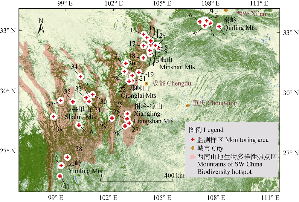
图1 西南山地红外相机监测网络内的监测样区(底图为森林分布, 绿色、黄色、蓝色分别为森林、非森林和水体)。编号含义同表1。
Fig. 1 The monitoring areas within the Camera-trapping Network for the Mountains of Southwest China (Forest cover as background, where green, sand and blue represent forest, non-forest and water body, respectively). Numbers refer to the monitoring area ID in Table 1.
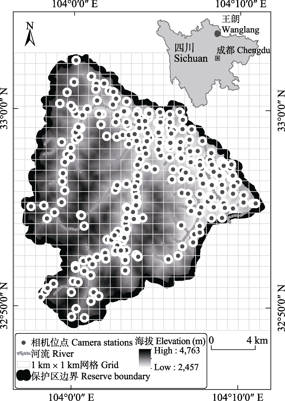
图2 四川王朗国家级自然保护区2014-2018年红外相机监测位点
Fig. 2 Camera-trapping survey stations in the Wanglang National Nature Reserve, Sichuan Province, 2014-2018
| [1] | He BS, Sun RQ, Chen P, Dong W, Wang J, Wang DJ, Li S (2016) Baseline survey of mammal and bird diversity using camera-trapping in the Changqing National Nature Reserve of Shaanxi Province. Acta Theriologica Sinica, 36, 348-356.(in Chinese with English abstract) |
| [ 何百锁, 孙瑞谦, 陈鹏, 董伟, 王军, 王大军, 李晟 (2016) 基于红外相机技术调查长青国家级自然保护区兽类和鸟类多样性. 兽类学报, 36, 348-356.] | |
| [2] | Hu XX, Li JQ, Luo X, Zeweng TX, Chen X, Zhang LS, Guan TP (2019) Preliminary survey of mammal and bird biodiversity using camera traps in the Yading National Nature Reserve of Sichuan Province, China. Acta Theriologica Sinica, 39, 333-343.(in Chinese with English abstract) |
| [ 胡茜茜, 李佳琦, 罗旭, 泽翁他许, 陈星, 张卢水, 官天培 (2019) 基于红外相机的四川亚丁国家级自然保护区鸟兽多样性初报. 兽类学报, 39, 333-343.] | |
| [3] | Hu XX, Zheng WC, Li JQ, Li S, Yang H, Chen X, Guan TP (2018) Preliminary survey on mammal and bird diversity at Siguniang Mountains National Nature Reserve, Sichuan, China. Biodiversity Science, 26, 1325-1331.(in Chinese with English abstract) |
| [ 胡茜茜, 郑维超, 李佳琦, 李晟, 杨晗, 陈星, 官天培 (2018) 四姑娘山国家级自然保护区鸟兽多样性初步调查. 生物多样性, 26, 1325-1331.] | |
| [4] | Jiang ZG, Jiang JP, Wang YZ, Zhang E, Zhang YY, Li LL, Xie F, Cai B, Cao L, Zheng GM, Dong L, Zhang ZW, Ding P, Luo ZH, Ding CQ, Ma ZJ, Tang SH, Cao WX, Li CW, Hu HJ, Ma Y, Wu Y, Wang YX, Zhou KY, Liu SY, Chen YY, Li JT, Feng ZJ, Wang Y, Wang B, Li C, Song XL, Cai L, Zang CX, Zeng Y, Meng ZB, Fang HX, Ping XG (2016) Red List of China’s Vertebrates. Biodiversity Science, 24, 500-551.(in Chinese and in English) |
| [ 蒋志刚, 江建平, 王跃招, 张鹗, 张雁云, 李立立, 谢锋, 蔡波, 曹亮, 郑光美, 董路, 张正旺, 丁平, 罗振华, 丁长青, 马志军, 汤宋华, 曹文宣, 李春旺, 胡慧建, 马勇, 吴毅, 王应祥, 周开亚, 刘少英, 陈跃英, 李家堂, 冯祚建, 王燕, 王斌, 李成, 宋雪琳, 蔡蕾, 臧春鑫, 曾岩, 孟智斌, 方红霞, 平晓鸽 (2016) 中国脊椎动物红色名录. 生物多样性, 24, 500-551.] | |
| [5] | Jiang ZG, Liu SY, Wu Y, Jiang XL, Zhou KY (2017) China’s mammal diversity (2nd edition). Biodiversity Science, 25, 886-895.(in Chinese with English abstract) |
| [ 蒋志刚, 刘少英, 吴毅, 蒋学龙, 周开亚 (2017) 中国哺乳动物多样性(第2版). 生物多样性, 25, 886-895.] | |
| [6] | Lei KM, Sun HO, Mai L, Kuang PG, Liu Y, Zhao SJ, Xiao CL, Liu Y (2016) Using the infrared camera to investigate animal diversity in Jiuzhaigou National Nature Reserve. Journal of Sichuan Forestry Science and Technology, 37(1), 88-91.(in Chinese with English abstract) |
| [ 雷开明, 孙鸿鸥, 麦浪, 旷培刚, 刘源, 赵上娟, 肖长林, 刘洋 (2016) 利用红外相机调查九寨沟国家级自然保护区鸟兽多样性. 四川林业科技, 37(1), 88-91.] | |
| [7] | Li JQ, Xu HG, Wan YQ, Sun JX, Li S, Cai L (2018) Progress in construction of China Mammal Diversity Observation Network (China BON-Mammals). Journal of Ecology and Rural Environment, 34, 12-19.(in Chinese with English abstract) |
| [ 李佳琦, 徐海根, 万雅琼, 孙佳欣, 李晟, 蔡蕾 (2018) 全国哺乳动物多样性观测网络(China BON-Mammals)建设进展. 生态与农村环境学报, 34, 12-19.] | |
| [8] | Li S, McShea WJ, Wang D, Huang J, Shao L (2012a) A direct comparison of camera-trapping and sign transects for monitoring wildlife in the Wanglang National Nature Reserve, China. Wildlife Society Bulletin, 36, 538-545. |
| [9] | Li S, McShea WJ, Wang D, Lu Z, Gu X (2012b) Gauging the impact of management expertise on the distribution of large mammals across protected areas. Diversity and Distributions, 18, 1166-1176. |
| [10] |
Li S, McShea WJ, Wang DJ, Gu XD, Zhang XF, Zhang L, Shen XL (2020) Retreat of large carnivores across the giant panda distribution range. Nature Ecology & Evolution, 4, 1327-1331.
URL PMID |
| [11] | Li S, Wang DJ, Bu HL, Liu XG, Jin T (2016) Camera-trapping survey on the mammal diversity of the Laohegou Nature Reserve, Sichuan Province. Acta Theriologica Sinica, 36, 282-291.(in Chinese with English abstract) |
| [ 李晟, 王大军, 卜红亮, 刘小庚, 靳彤 (2016) 四川省老河沟自然保护区兽类多样性红外相机调查. 兽类学报, 36, 282-291.] | |
| [12] | Li S, Wang DJ, Gu XD, McShea WJ (2010a) Beyond pandas, the need for a standardized monitoring protocol for large mammals in Chinese nature reserves. Biodiversity and Conservation, 19, 3195-3206. |
| [13] | Li S, Wang DJ, Lu Z, McShea WJ (2010b) Cats living with pandas: The status of wild felids within giant panda range, China. Cat News, 52, 20-23. |
| [14] |
Li S, Wang DJ, Xiao ZS, Li XH, Wang TM, Feng LM, Wang Y (2014) Camera-trapping in wildlife research and conservation in China: Review and outlook. Biodiversity Science, 22, 685-695.(in Chinese with English abstract)
DOI URL |
| [ 李晟, 王大军, 肖治术, 李欣海, 王天明, 冯利民, 王云 (2014) 红外相机技术在我国野生动物研究与保护中的应用与前景. 生物多样性, 22, 685-695.] | |
| [15] |
McShea WJ, Forrester T, Costello R, He Z, Kays R (2016) Volunteer-run cameras as distributed sensors for macrosystem mammal research. Landscape Ecology, 31, 55-66.
DOI URL |
| [16] |
Myers N, Mittermeier RA, Mittermeier CG, da Fonseca GAB, Kent J (2000) Biodiversity hotspots for conservation priorities. Nature, 403, 853-858.
URL PMID |
| [17] | Shang XT, Luo CP, Li B, Zheng Y, Zhou ZQ, Zhang L, Li S (2020) Diversity and fauna composition of birds in the Wanglang National Nature Reserve, Sichuan. Sichuan Journal of Zoology, 39, 93-106.(in Chinese with English abstract) |
| [ 尚晓彤, 罗春平, 李斌, 郑勇, 周智强, 张立, 李晟 (2020) 四川王朗国家级自然保护区鸟类多样性与区系组成. 四川动物, 39, 93-106.] | |
| [18] |
Shen XL, Li S, McShea WJ, Wang DJ, Yu JP, Shi XG, Dong W, Mi XC, Ma KP (2020) Effectiveness of management zoning designed for flagship species in protecting sympatric species. Conservation Biology, 34, 158-167.
DOI URL PMID |
| [19] |
Shi XG, Hu Q, Li JQ, Tang Z, Yang J, Li WJ, Shen XL, Li S (2017) Camera-trapping surveys of the mammal and bird diversity in Wolong National Nature Reserve, Sichuan Province. Biodiversity Science, 25, 1131-1136.(in Chinese with English abstract)
DOI URL |
| [ 施小刚, 胡强, 李佳琦, 唐卓, 杨建, 李文静, 申小莉, 李晟 (2017) 利用红外相机调查四川卧龙国家级自然保护区鸟兽多样性. 生物多样性, 25, 1131-1136.] | |
| [20] |
Shi XY, Shi XG, Hu Q, Guan TP, Fu Q, Zhang J, Yao M, Li S (2019) Evaluating the potential habitat overlap and predation risk between snow leopards and free-range yaks in the Qionglai Mountains, Sichuan. Biodiversity Science, 27, 951-959.(in Chinese with English abstract)
DOI URL |
| [ 史晓昀, 施小刚, 胡强, 官天培, 付强, 张剑, 姚蒙, 李晟 (2019) 四川邛崃山脉雪豹与散放牦牛潜在分布重叠与捕食风险评估. 生物多样性, 27, 951-959.] | |
| [21] | Wang DJ, Li S, McShea WJ, Li MF (2006) Use of remote-trip cameras for wildlife surveys and evaluating the effectiveness of conservation activities at a nature reserve in Sichuan Province, China. Environmental Management, 28, 942-951. |
| [22] |
Wang F, McShea WJ, Wang DJ, Li S (2015) Shared resources between giant panda and sympatric wild and domestic mammals. Biological Conservation, 186, 319-325.
DOI URL |
| [23] |
Wang F, McShea WJ, Wang DJ, Li S, Zhao Q, Wang H, Lu Z (2014) Evaluating landscape options for corridor restoration between giant panda reserves. PLoS ONE, 9, e105086.
DOI URL PMID |
| [24] | Xu HM, Wang HH, Zhang ZY, Lei JD, Li SW (2018) Evidence of wolf occurrence in the southern area of the Three Parallel Rivers Region. Sichuan Journal of Zoology, 37, 463-464.(in Chinese) |
| [ 徐会明, 王浩瀚, 张志云, 雷建东, 李施文 (2018) 狼分布于三江并流区南部区域的实证资料. 四川动物, 37, 463-464.] | |
| [25] | Zheng GM (2017) A Checklist on the Classification and Distribution of the Birds of China, 3rd edn. Science Press, Beijing.(in Chinese) |
| [ 郑光美 (2017) 中国鸟类分类与分布名录(第三版), 科学出版社, 北京.] | |
| [26] |
Zhu SY, Duan F, Li S (2017) Promoting diversity inventory and monitoring of birds through the camera-trapping network in China: Status, challenges and future outlook. Biodiversity Science, 25, 1114-1122.(in Chinese with English abstract)
DOI URL |
| [ 朱淑怡, 段菲, 李晟 (2017) 基于红外相机网络促进我国鸟类多样性监测: 现状、问题与前景. 生物多样性, 25, 1114-1122.] |
| [1] | 王倩倩, 陈孝国, 朱锐丰, 张明春, 王新, 李世林, 仁增江措, 彭武, 杨彪. 藏东南黑麝及其同域有蹄类物种的生态适应性差异[J]. 生物多样性, 2026, 34(5): 25433-. |
| [2] | 冯杰, 李彦知, 王书理, 李岚曦, 丁鹏飞, 吕冰薇, 孟吉, 史湘莹, 李雪阳. 西南山地有蹄类栖息地利用率多年变化及环境影响: 以关坝村红外相机监测为例[J]. 生物多样性, 2026, 34(5): 25261-. |
| [3] | 孔孜亦, 王德港, 王建涛, 裴志永, 孙晶, 张长春, 张军国. 基于SCD-HRNet模型的野生动物姿态估计及其在生物多样性监测中的应用: 以内蒙古赛罕乌拉地区为例[J]. 生物多样性, 2026, 34(4): 25287-. |
| [4] | 张同, 梁力文, 王长剑, 舒服, 王璐, 郭泽光, 卓玛曲珍, 钱芊, 蒋安莉, 敖俊杰, 彭兴文, 伍小刚, 向左甫, 郭克疾, 廖梓延. 基于红外相机的西藏芒康滇金丝猴国家级自然保护区鸟兽多样性及代表性物种的季节性空间利用特征[J]. 生物多样性, 2026, 34(4): 25435-. |
| [5] | 吴春莹, Viorel D. Popescu, 季吟秋. 生物多样性评估挑战的层级占有率模型解决路径[J]. 生物多样性, 2026, 34(1): 25386-. |
| [6] | 周铝, 郭画, 姚世贸, 田成. 王朗国家级自然保护区红腹角雉时空分布模式[J]. 生物多样性, 2025, 33(7): 24537-. |
| [7] | 李基才, 邵长亮, 高帅帅, 李佳. 新疆卡拉麦里国家公园候选区蒙古野驴夏季水源利用规律、活动范围和适宜生境分布[J]. 生物多样性, 2025, 33(7): 24509-. |
| [8] | 毛静, 王婧, 黄杰, 熊姝红, 张自亮, 张佑祥, 吴涛. 湖南高望界国家级自然保护区2021-2023年鸟兽多样性监测数据集[J]. 生物多样性, 2025, 33(6): 24489-. |
| [9] | 黄定旭, 肖文宏, 白小节, 刘邦友, 黎源君, 梁盛, 肖治术, 刘伟. 赤水桫椤国家级自然保护区中小型食肉目动物昼夜活动节律的比较[J]. 生物多样性, 2025, 33(6): 24376-. |
| [10] | 罗敏, 杨永川, 靳程, 周礼华, 龙宇潇. 重庆中心城区城市森林兽类组成特征及其对人类活动的响应[J]. 生物多样性, 2025, 33(5): 24402-. |
| [11] | 农荞伊, 曹军, 程文达, 彭艳琼. 不同方法对蜜蜂总科昆虫资源与多样性监测效果的比较[J]. 生物多样性, 2025, 33(4): 25057-. |
| [12] | 龚翠凤, 韦伟, 罗概, 韩一敏, 吴鹏程, 何梦楠, 闵清悦, 付强, 陈鹏. 大熊猫国家公园崇州片区有蹄类动物空间分布及共存关系[J]. 生物多样性, 2025, 33(3): 24260-. |
| [13] | 王大伟, 程帅, 冯佳伟, 王天明. 东北地区张广才岭2015-2020年野生动物红外相机监测数据集[J]. 生物多样性, 2025, 33(2): 24384-. |
| [14] | 汪锦辉, 刘宝权, 周晓, 梁子安, 孔令伟, 方卫军, 孙晗靖, 金挺浩, 厉亮, 何珂, 朱振贤. 基于红外相机监测的杭州市鸟兽多样性分析与优先保护关键区域评估[J]. 生物多样性, 2025, 33(12): 25265-. |
| [15] | 李菡, 董伟, 陆江涛, 吴永杰, 何兴成, 刘林, 木留里哈, 张学林. 四川省甘洛县马鞍山省级自然保护区及周边地区红外相机鸟兽监测数据集[J]. 生物多样性, 2025, 33(10): 25165-. |
| 阅读次数 | ||||||
|
全文 |
|
|||||
|
摘要 |
|
|||||
备案号:京ICP备16067583号-7
Copyright © 2026 版权所有 《生物多样性》编辑部
地址: 北京香山南辛村20号, 邮编:100093
电话: 010-62836137, 62836665 E-mail: biodiversity@ibcas.ac.cn
![]()