
生物多样性 ›› 2016, Vol. 24 ›› Issue (1): 20-29. DOI: 10.17520/biods.2015177 cstr: 32101.14.biods.2015177
吴文1,2, 李月辉1,*( ), 胡远满1, 陈龙1,2, 李悦3, 李泽鸣1, 聂志文1,2, 陈探1,2
收稿日期:2015-06-22
接受日期:2015-10-26
出版日期:2016-01-20
发布日期:2016-06-12
通讯作者:
李月辉
基金资助:
Wen Wu1,2, Yuehui Li1,*(), Yuanman Hu1, Long Chen1,2, Yue Li3, Zeming Li1, Zhiwen Nie1,2, Tan Chen1,2
Received:2015-06-22
Accepted:2015-10-26
Online:2016-01-20
Published:2016-06-12
摘要:
通过2014-2015年两次冬季野外调查, 将收集的79处马鹿(Cervus elaphus)出现信息作为分布点数据, 选取地形、景观类型、植被特征和人类干扰4类19种因子作为环境变量, 利用最大熵(maximum entropy, MaxEnt)模型, 分析了小兴安岭铁力林业局辖区马鹿种群冬季潜在适宜生境分布特征和主要环境因子对马鹿分布的影响。结果显示: 模型预测精度较高, 训练集与验证集的平均AUC(area under the curve, 受试工作者曲线下面积)值分别为0.949和0.958; Jackknife检验结果表明: 景观类型因子对马鹿生境选择的影响较大; 坡向、距大路距离、距混交林距离、距灌草地距离和距农田距离是影响马鹿生境分布的主要环境因子, 其综合贡献值依次为27.8%、23.9%、19.5%、15.3%和10.4%; 距小路距离对马鹿分布影响较小。我们依据MaxEnt模型最大约登指数, 找到最佳中断点0.22作为阈值将马鹿冬季栖息地划分为适宜和不适宜两个等级, 其面积分别为663.49 km2和1,378.85 km2, 分别占研究区总面积的32%和68%。马鹿的适宜生境主要分布在铁力林业局辖区的东部山地和中部林地等区域; 南部地区接近铁力市区, 人类活动频繁, 不适宜马鹿栖息。对马鹿种群的保护管理措施提出3点建议: 控制人为干扰; 构建多样性景观; 优先保护马鹿的潜在适宜生境分布区。
吴文, 李月辉, 胡远满, 陈龙, 李悦, 李泽鸣, 聂志文, 陈探 (2016) 小兴安岭南麓马鹿冬季适宜生境评价. 生物多样性, 24, 20-29. DOI: 10.17520/biods.2015177.
Wen Wu, Yuehui Li, Yuanman Hu, Long Chen, Yue Li, Zeming Li, Zhiwen Nie, Tan Chen (2016) Suitable winter habitat for Cervus elaphus on the southern slope of the Lesser Xing’an Mountains. Biodiversity Science, 24, 20-29. DOI: 10.17520/biods.2015177.
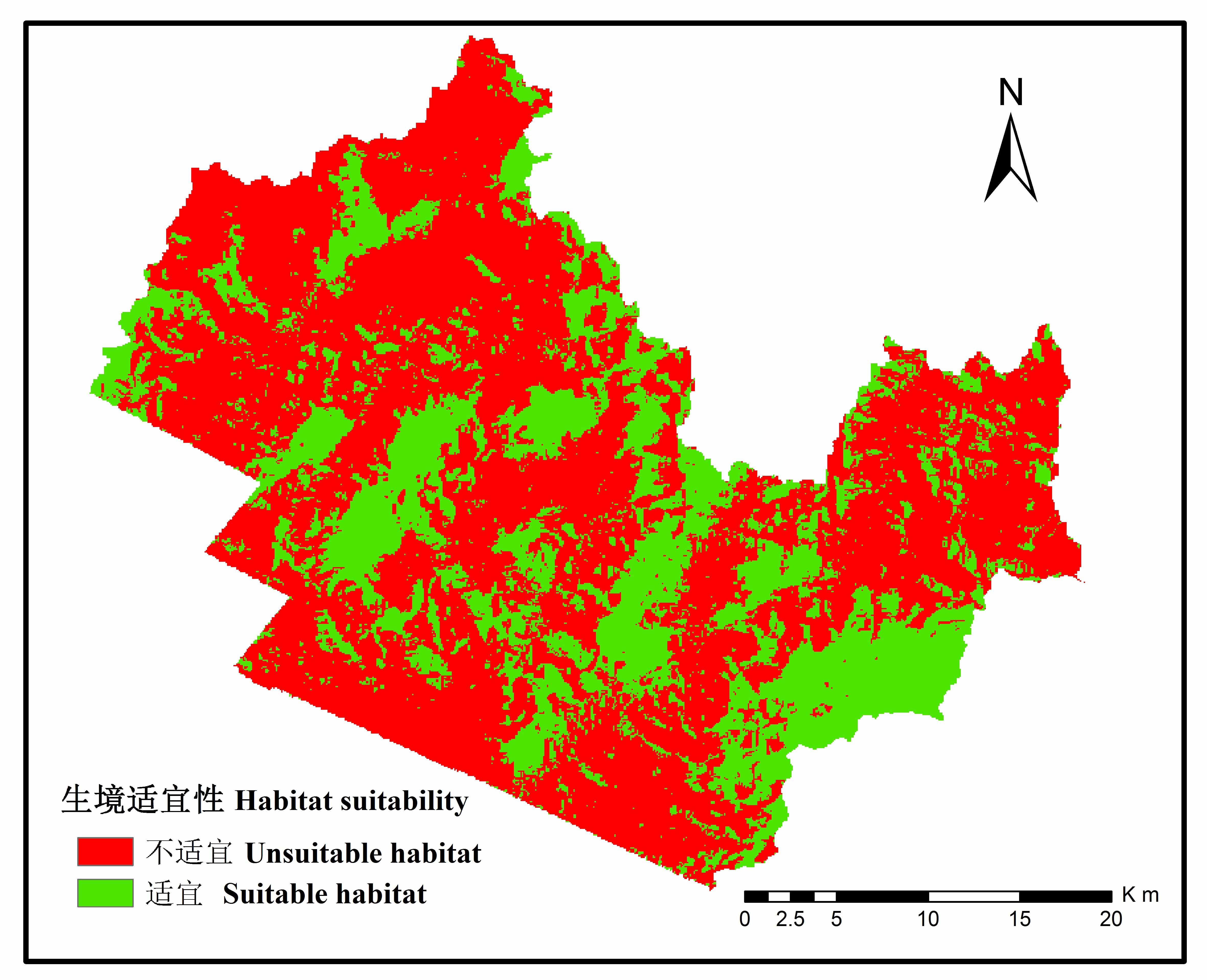
图1 小兴安岭铁力林业局辖区马鹿冬季适宜生境分布图
Fig. 1 The suitable winter habitat map of red deer (Cervus elaphus) in the Tieli Forestry Bureau of the Lesser Xing’an Mountains
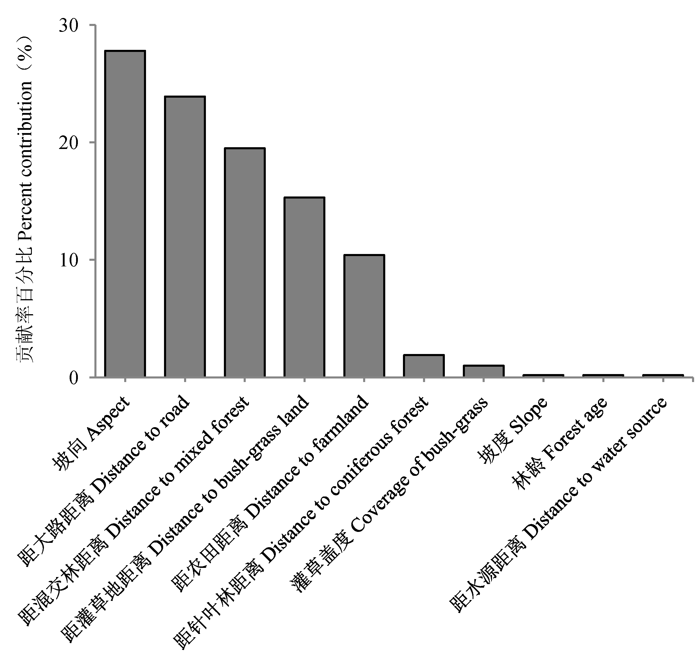
图2 环境因子对马鹿冬季生境适宜性的贡献率
Fig. 2 The contribution of environmental variables to red deer (Cervus elaphus) winter habitat suitability
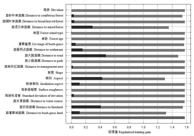
图3 环境变量Jackknife分析(深色条带表示各变量对预测结果的增益, 浅灰色条带的长度表示除该变量外其他所有变量对模型预测的增益, 最下方灰色条带表示所有变量进入模型后的增益结果)。
Fig. 3 Jackknife analysis of environmental variables. Dark, Gain with each variable; Light gray, Gain without variable; The bottom line, Gain with all variables.
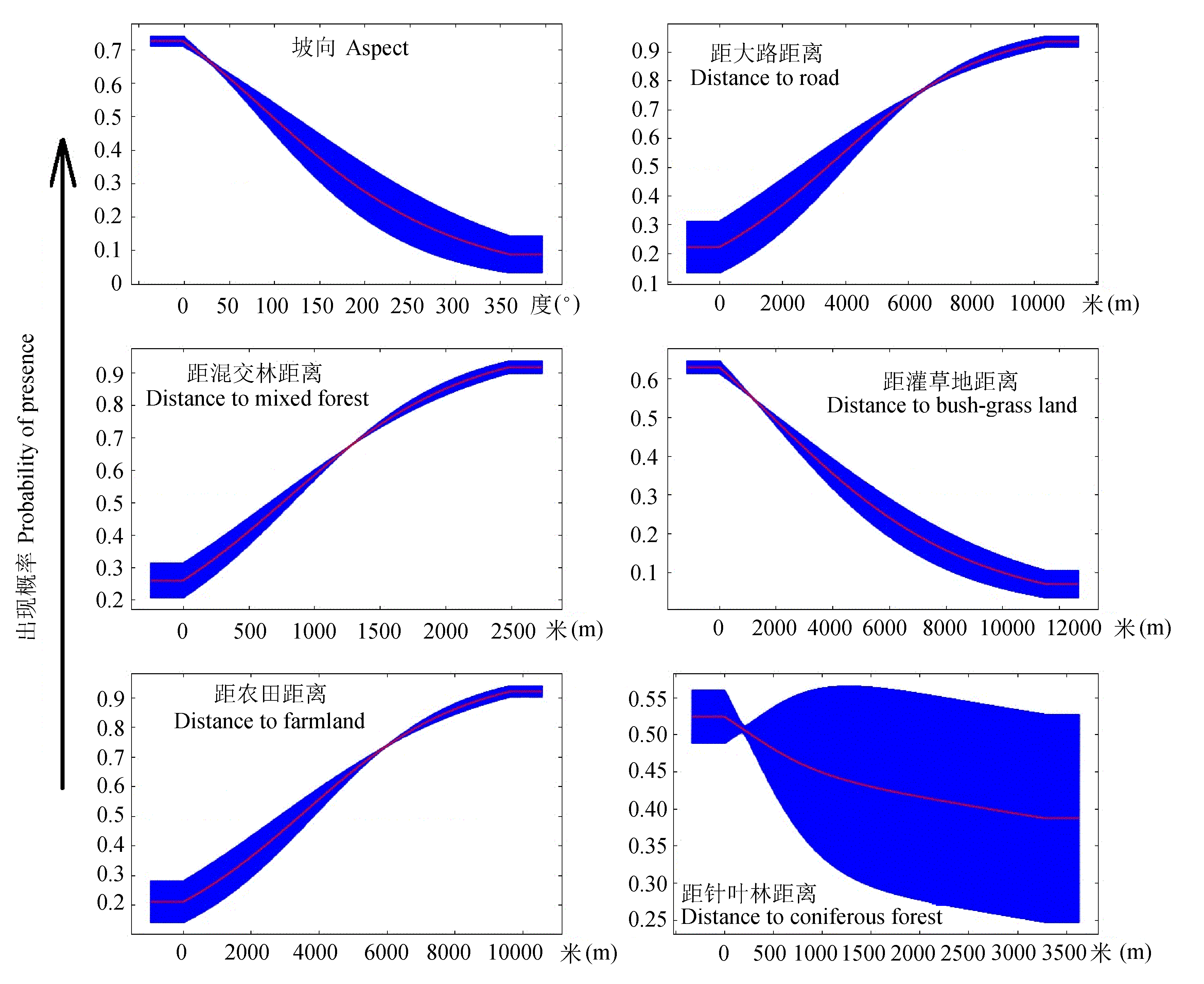
图4 模型中贡献值前6位的环境变量对预测概率的反应曲线, 10次运行结果均值(红色)±标准差(蓝色)。
Fig. 4 Response curves of the top six important variables in MaxEnt models for Red deer, and show the mean response of the cross-validated models with 10 replicate runs (red) and the mean ± one standard deviation (blue).
| 1 | Araújo MB, Pearson RG, Thuiller W, Erhard M (2005) Validation of species-climate impact models under climate change. Global Change Biology, 11, 1504-1513. |
| 2 | Araújo MB, Alagador D, Cabeza M, Nogues-Bravo D, Thuiller W (2011) Climate change threatens European conservation areas. Ecology Letters, 14, 484-492. |
| 3 | Behdarvand N, Kaboli M, Ahmadi M, Nourani E, Mahini AS, Aghbolaghi MA (2014) Spatial risk model and mitigation implications for wolf-human conflict in a highly modified agroecosystem in western Iran. Biological Conservation, 177, 156-164. |
| 4 | Bonnot N, Morellet N, Verheyden H, Cargnelutti B, Lourtet B, Klein F, Hewison AJM (2013) Habitat use under predation risk: hunting, roads and human dwellings influence the spatial behaviour of roe deer. European Journal of Wildlife Research, 59, 185-193. |
| 5 | Borkowski J, Ukalska J (2008) Winter habitat use by red and roe deer in pine-dominated forest. Forest Ecology and Management, 255, 468-475. |
| 6 | Brambilla M, Saporetti F (2014) Modelling distribution of habitats required for different uses by the same species: implications for conservation at the regional scale. Biological Conservation, 174, 39-46. |
| 7 | Brown JL (2014) SDMtoolbox: a python-based GIS toolkit for landscape genetic, biogeographic and species distribution model analyses. Methods in Ecology and Evolution, 5, 694-700. |
| 8 | Catry FX, Rego FC, Bacao F, Moreira F (2009) Modeling and mapping wildfire ignition risk in Portugal. International Journal of Wildland Fire, 18, 921-931. |
| 9 | Chen XM, Lei YC, Zhang XQ, Jia HY (2012) Effects of sample sizes on accuracy and stability of Maximum Entropy Model in predicting species distribution. Scientia Silvae Sinicae, 48(1), 53-59. (in Chinese with English abstract) |
| [陈新美, 雷渊才, 张雄清, 贾宏炎 (2012) 样本量对MaxEnt模型预测物种分布精度和稳定性的影响. 林业科学, 48(1), 53-59.] | |
| 10 | Chitale VS, Behera MD, Roy PS (2014) Future of endemic flora of biodiversity hotspots in India. PLoS ONE, 9, 1-15. |
| 11 | Coppes J, Braunisch V (2013) Managing visitors in nature areas: where do they leave the trails? A spatial model. Wildlife Biology, 19, 1-11. |
| 12 | Costa GC, Nogueira C, Machado RB, Colli GR (2010) Sampling bias and the use of ecological niche modeling in conservation planning: a field evaluation in a biodiversity hotspot. Biodiversity and Conservation, 19, 883-899. |
| 13 | Dou HL, Jiang GS, Stott P, Piao RZ (2013) Climate change impacts population dynamics and distribution shift of moose (Alces alces) in Heilongjiang Province of China. Ecological Research, 28, 625-632. |
| 14 | Elith J, Graham CH, Anderson RP, Dudik M, Ferrier S, Guisan A, Zimmermann NE (2006) Novel methods improve prediction of species’ distributions from occurrence data. Ecography, 29, 129-151. |
| 15 | Elith J, Leathwick JR (2009) Species distribution models: ecological explanation and prediction across space and time. Annual Review of Ecology, Evolution and Systematics, 40, 677-697. |
| 16 | Fourcade Y, Engler JO, Besnard AG, Roedder D, Secondi J (2013) Confronting expert-based and modelled distributions for species with uncertain conservation status: a case study from the corncrake (Crex crex). Biological Conservation, 167, 161-171. |
| 17 | Garcia CV, Woodard PM, Titus SJ, Adamowicz WL, Lee BS (1995) A logit model for predicting the daily occurrence of human caused forest-fires. International Journal of Wildland Fire, 5, 101-111. |
| 18 | Gogol-Prokurat M (2011) Predicting habitat suitability for rare plants at local spatial scales using a species distribution model. Ecological Applications, 21, 33-47. |
| 19 | Gong MH, Zhang JJ (2010) Discussion on wildlife survey methods in desert area: introduction of a new survey method. Sichuan Journal of Zoology, 29, 320-324. (in Chinese with English abstract) |
| [龚明昊, 张建军 (2010) 荒漠地区野生动物调查方法探讨: 一种新的调查方法介绍. 四川动物, 29, 320-324.] | |
| 20 | He W, Bu RC, Liu HJ, Xiong ZP, Hu YM (2013) Prediction of the effects of climate change on the potential distribution of mire in northeastern China. Acta Ecologica Sinica, 33, 6314-6319. (in Chinese with English abstract) |
| [贺伟, 布仁仓, 刘宏娟, 熊在平, 胡远满 (2013) 气候变化对东北沼泽湿地潜在分布的影响. 生态学报, 33, 6314-6319.] | |
| 21 | Hemami MR, Watkinson AR, Dolman PM (2004) Habitat selection by sympatric muntjac (Muntiacus reevesi) and roe deer (Capreolus capreolus) in a lowland commercial pine forest. Forest Ecology and Management, 194, 49-60. |
| 22 | Hou N, Dai Q, Ran JH, Jiao YY, Cheng Y, Zhao C (2014) A corridor design for the giant panda in the Niba Mountain of China. Chinese Journal of Applied and Environmental Biology, 20, 1039-1045. (in Chinese with English abstract) |
| [侯宁, 戴强, 冉江洪, 焦迎迎, 程勇, 赵成 (2014) 大相岭山系泥巴山大熊猫生境廊道设计. 应用与环境生物学报, 20, 1039-1045.] | |
| 23 | Hu J, Jiang Z (2010) Predicting the potential distribution of the endangered Przewalski’s gazelle. Journal of Zoology (Lon- don), 282, 54-63. |
| 24 | Hu LL, Zhang HY, Qin L, Yan BQ (2012) Current distribution of Schisandra chinensis in China and its predicted responses to climate change. Chinese Journal of Applied Ecology, 23, 2445-2450. (in Chinese with English abstract) |
| [胡理乐, 张海英, 秦岭, 闫伯前 (2012) 中国五味子分布范围及气候变化影响预测. 应用生态学报, 23, 2445-2450.] | |
| 25 | Jiang GS (2007) Ecological Effects of Human Disturbances on Moose and Roe Deer and Their Adaptation Mechanisms at Multiple Spatial Scale. PhD dissertation, Northeast Forestry University, Harbin. (in Chinese with English abstract) |
| [姜广顺 (2007) 多空间尺度下驼鹿和狍受人类干扰的生态效应及其适应机制研究. 博士学位论文, 东北林业大学, 哈尔滨.] | |
| 26 | Jiang GS, Zhang MH, Ma JZ (2005) The fragmentation and impact factors of red deer habitat in Wandashan region, Heilongjiang Province, China. Acta Ecologica Sinica, 25, 1691-1698. (in Chinese with English abstract) |
| [姜广顺, 张明海, 马建章 (2005) 黑龙江省完达山地区马鹿生境破碎化及其影响因子. 生态学报, 25, 1691-1698.] | |
| 27 | Jiang ZG (1987) Jacknife method on niche and its application to the research of alpine pika (Ochatona curzoniae) |
| [蒋志刚(1987) 生态龛的刀切法研究及在高原鼠兔生态龛研究中的应用. 兽类学报, 7, 20-27.] | |
| 28 | Li GQ, Liu CC, Liu YG, Yang J, Zhang XS, Guo K (2013) Advances in theoretical issues of species distribution models. Acta Ecologica Sinica, 33, 4827-4835. (in Chinese with English abstract) |
| [李国庆, 刘长成, 刘玉国, 杨军, 张新时, 郭柯 (2013) 物种分布模型理论研究进展. 生态学报, 33, 4827-4835.] | |
| 29 | Li YH, Wu W, Xiong ZP, Hu YM, Chang Y, Xiao DN (2014) Effects of forest roads on habitat pattern for sables in Da Hinggan Mountains, northeasten China. Chinese Geo- graphical Science, 24, 1-12. |
| 30 | Li YK, Zhang MH, Jiang ZG (2008) Habitat selection by wapiti (Cervus elaphus xanthopygus) in the Wandashan Mountains based on habitat availability. Acta Ecologica Sinica, 28, 4619-4628. (in Chinese with English abstract) |
| [李言阔, 张明海, 蒋志刚 (2008) 基于生境可获得性的完达山地区马鹿(Cervus elaphus xanthopygus)冬季生境选择. 生态学报, 28, 4619-4628.] | |
| 31 | Luo C, Xu WH, Zhou ZX, Ouyang ZY, Zhang L (2011) Habitat prediction for forest musk deer (Moschus berezovskii) in Qinling Mountain range based on niche model. Acta Ecologica Sinica, 31, 1221-1229. (in Chinese with English abstract) |
| [罗翀, 徐卫华, 周志翔, 欧阳志云, 张路 (2011) 基于生态位模型的秦岭山系林麝生境预测. 生态学报, 31, 1221-1229.] | |
| 32 | Luo Y, Zhang MM, Liu ZS, Li ZG, Hu TH, Zhai H (2009) Winter and spring habitat selection of red deer (Cervus elaphus alxaicus) in the Helan Mountains, China. Acta Ecologica Sinica, 29, 2757-2763. (in Chinese with English abstract) |
| [骆颖, 张明明, 刘振生, 李志刚, 胡天华, 翟昊 (2009) 贺兰山马鹿冬春季生境的选择. 生态学报, 29, 2757-2763.] | |
| 33 | Ma SM, Nie YB, Geng QL, Wang RX (2014) Impact of climate change on suitable distribution range and spatial pattern in Amygdalus mongolica. Chinese Journal of Plant Ecology, 38, 262-269. (in Chinese with English abstract) |
| [马松梅, 聂迎彬, 耿庆龙, 王荣学 (2014) 气候变化对蒙古扁桃适宜分布范围和空间格局的影响. 植物生态学报, 38, 262-269.] | |
| 34 | Ohashi H, Yoshikawa M, Oono K, Tanaka N, Hatase Y, Murakami Y (2014) The impact of Sika deer on vegetation in Japan: setting management priorities on a national scale. Environmental Management, 54, 631-640. |
| 35 | Ossi F, Gaillard JM, Hebblewhite M, Cagnacci F (2015) Snow sinking depth and forest canopy drive winter resource selection more than supplemental feeding in an alpine population of roe deer. European Journal of Wildlife Research, 61, 111-124. |
| 36 | Pena JCD, Kamino LHY, Rodrigues M, Mariano-Neto E, de Siqueira MF (2014) Assessing the conservation status of species with limited available data and disjunct distribution. Biological Conservation, 170, 130-136. |
| 37 | Phillips SJ, Anderson RP, Schapire RE (2006) Maximum entropy modeling of species geographic distributions. Ecological Modelling, 190, 231-259. |
| 38 | Phillips SJ, Dudik M (2008) Modeling of species distributions with Maxent: new extensions and a comprehensive evaluation. Ecography, 31, 161-175. |
| 39 | Piao RZ, Guan GS, Zhang MH (1995) Population size and distribution of moose in China. Acta Theriologica Sinica, 15, 11-16. (in Chinese with English abstract) |
| [朴仁珠, 关国生, 张明海 (1995) 中国驼鹿种群数量及分布现状的研究. 兽类学报, 15, 11-16.] | |
| 40 | Piekielek NB, Hansen AJ (2012) Extent of fragmentation of coarse-scale habitats in and around US National Parks. Biological Conservation, 155, 13-22. |
| 41 | Putman RJ (1996) Ungulates in temperate forest ecosystems: perspectives and recommendations for future research. Forest Ecology and Management, 88, 205-214. |
| 42 | Qi ZX, Xu WH, Xiong XY, Ouyang ZY, Zheng H, Gan DX (2011) Assessment of potential habitat for Ursus thibetanus in the Qinling Mountains. Biodiversity Science, 19, 343-352. (in Chinese with English abstract) |
| [齐增湘, 徐卫华, 熊兴耀, 欧阳志云, 郑华, 甘德欣 (2011) 基于MAXENT模型的秦岭山系黑熊潜在生境评价. 生物多样性, 19, 343-352.] | |
| 43 | Qin Y, Zhang MH (2009) Review of researches of red deer (Cervus elaphus) and perspects in China. Chinese Journal of Wildlife, 30, 100-104. (in Chinese with English abstract) |
| [秦瑜, 张明海 (2009) 中国马鹿的研究现状及展望. 野生动物, 30, 100-104.] | |
| 44 | Razgour O, Hanmer J, Jones G (2011) Using multi-scale modelling to predict habitat suitability for species of conservation concern: the grey long-eared bat as a case study. Biological Conservation, 144, 2922-2930. |
| 45 | Silva VDE, Pressey RL, Machado RB, VanDerWal J, Wiederhecker HC, Werneck FP, Colli GR (2014) Formulating conservation targets for a gap analysis of endemic lizards in a biodiversity hotspot. Biological Conservation, 180, 1-10. |
| 46 | Stehman SV, Salzer DW (2000) Estimating density from surveys employing unequal-area belt transects. Wetlands, 20, 512-519. |
| 47 | Sun L, Xu HG, Wu J, Lei JC, Cui P (2014) Impact of climate change on distribution of breeding places of white-naped crane in China. Journal of Ecology and Rural Environment, 30, 595-600. (in Chinese with English abstract) |
| [孙立, 徐海根, 吴军, 雷军成, 崔鹏 (2014) 气候变化对我国白枕鹤繁殖地分布的影响. 生态与农村环境学报, 30, 595-600.] | |
| 48 | Thomas L, Buckland ST, Rexstad EA, Laake JL, Strindberg S, Hedley SL, Bishop JRB, Marques TA, Burnham KP (2010) Distance software: design and analysis of distance sampling surveys for estimating population size. Journal of Applied Ecology, 47, 5-14. |
| 49 | Tian Y, Feng YJ, Zhang CL, Yu BC, Tang XP, Hu HJ (2015) Effectiveness of line transects during wild animal surveys in mountain forests of South China. Biodiversity Science, 23, 109-115. (in Chinese with English abstract) |
| [田园, 冯永军, 张春兰, 遇宝成, 唐小平, 胡慧建 (2015) 样线法在南方山地生态系统野生动物调查中的试点效果评价. 生物多样性, 23, 109-115.] | |
| 50 | Vieilledent G, Cornu C, Sanchez AC, Pock-Tsy JML, Danthu P (2013) Vulnerability of baobab species to climate change and effectiveness of the protected area network in Madagascar: towards new conservation priorities. Biological Conservation, 166, 11-22. |
| 51 | Waltert M, Meyer B, Shanyangi MW, Balozi JJ, Kitwara O, Qolli S, Krischke H, Muhlenberg M (2008) Foot surveys of large mammals in woodlands of western Tanzania. Journal of Wildlife Management, 72, 603-610. |
| 52 | Wang C, Lin HL, He L, Cao AC (2014) Research on responses of Eupatorium adenophorum’s potential distribution to climate change. Acta Prataculturae Sinica, 23(4), 20-30. (in Chinese with English abstract) |
| [王翀, 林慧龙, 何兰, 曹坳程 (2014) 紫茎泽兰潜在分布对气候变化响应的研究. 草业学报, 23(4), 20-30.] | |
| 53 | Wilson JW, Sexton JO, Jobe RT, Haddad NM (2013) The relative contribution of terrain, land cover, and vegetation structure indices to species distribution models. Biological Conservation, 164, 170-176. |
| 54 | Xing DL, Hao ZQ (2011) The principle of maximum entropy and its applications in ecology. Biodiversity Science, 19, 295-302. (in Chinese with English abstract) |
| [邢丁亮, 郝占庆 (2011) 最大熵原理及其在生态学研究中的应用. 生物多样性, 19, 295-302.] | |
| 55 | Xu WH, Luo C (2010) Application of MAXENT model in Rhinopithecus roxllanae habitat assessment in Qinling Mountain. Forest Engineering, 26(2), 1-3. (in Chinese with English abstract) |
| [徐卫华, 罗翀 (2010) MAXENT模型在秦岭川金丝猴生境评价中的应用. 森林工程, 26(2), 1-3.] | |
| 56 | Yang ZX, Zhou GS, Yin XJ, Jia BR (2014) Geographic distribution of Larix gmelinii natural forest in China and its climatic suitability. Chinese Journal of Ecology, 33, 1429-1436. (in Chinese with English abstract) |
| [杨志香, 周广胜, 殷晓洁, 贾丙瑞 (2014) 中国兴安落叶松天然林地理分布及其气候适宜性. 生态学杂志, 33, 1429-1436.] | |
| 57 | Zhang CZ (2013) Study on Amur Tiger and Prey Monitoring, and Conflict Between Tiger and Human in Northeast China. PhD dissertation, Northeast Forestry University, Harbin. (in Chinese with English abstract) |
| [张常智 (2013) 东北虎及其猎物种群监测和人虎冲突研究. 博士学位论文, 东北林业大学, 哈尔滨.] | |
| 58 | Zhang Y, Zhang MH (2010) Evaluation system with FAHP of deer habitats in Northeast China. Chinese Journal of Wildlife, 31, 42-44. (in Chinese with English abstract) |
| [张宇, 张明海 (2010) 模糊层次分析法为基础的东北地区鹿类动物生境评价体系初探. 野生动物, 31, 42-44.] | |
| 59 | Zhou CL, Risalat T, Askar M, Amila A, Mahmut H (2013) Comparison of population size of Tianshan red deer (Cervus elaphus songaricus) on Karawushen Mountainous in Xinjiang based on three different methods. Sichuan Journal of Zoology, 32, 487-491. (in Chinese with English abstract) |
| [周璨林, 日沙来提·吐尔地, 艾斯卡尔·买买提, 阿米拉·阿布来提, 马合木提·哈力克 (2013) 三种方法对天山马鹿喀拉乌成山种群数量的比较. 四川动物, 32, 487-491.] | |
| 60 | Zhou SC, Zhang MH, Sun HY, Yin YX (2011) Prey biomass of the Amur tiger (Panthera tigris altaica) in the eastern Wanda Mountains of Heilongjiang Province, China. Acta Ecologica Sinica, 31, 145-153. (in Chinese with English abstract) |
| [周绍春, 张明海, 孙海义, 尹远新 (2011) 黑龙江省完达山东部林区东北虎猎物生物量. 生态学报, 31, 145-153.] | |
| 61 | Zhou SZ (2008) Evaluation of Effects of Natural Forest Protection Program. PhD dissertation, Chinese Academy of Forestry Sciences, Beijing. (in Chinese with English abstract) |
| [周少舟 (2008) 天然林资源保护工程效益评价. 博士学位论文, 中国林业科学研究院, 北京.] |
| [1] | 谷际岐, 赖江山, 王瑛, 吴浩然, 张雪, 宋晓彤, 邵小明, 娄安如. 联合物种分布模型与生物群落层次建模框架: 生态学理论、方法及应用[J]. 生物多样性, 2026, 34(1): 25364-. |
| [2] | 樊广泰, 陈奕宁, 何既白, 窦海龙, 陈纪元, 杨海涛, 沈秋, 关宏灿. 基于红外相机揭示浙江省金塘岛欧亚水獭对同域物种及人类干扰的时空响应[J]. 生物多样性, 2025, 33(9): 25148-. |
| [3] | 吉晟男, 韩佳蓉, 任月恒, 穆晓东, 朱彦鹏. 基于MaxEnt模型预测海南岛重点管理外来入侵植物适生区及其入侵风险[J]. 生物多样性, 2025, 33(8): 25037-. |
| [4] | 周铝, 郭画, 姚世贸, 田成. 王朗国家级自然保护区红腹角雉时空分布模式[J]. 生物多样性, 2025, 33(7): 24537-. |
| [5] | 李基才, 邵长亮, 高帅帅, 李佳. 新疆卡拉麦里国家公园候选区蒙古野驴夏季水源利用规律、活动范围和适宜生境分布[J]. 生物多样性, 2025, 33(7): 24509-. |
| [6] | 黄定旭, 肖文宏, 白小节, 刘邦友, 黎源君, 梁盛, 肖治术, 刘伟. 赤水桫椤国家级自然保护区中小型食肉目动物昼夜活动节律的比较[J]. 生物多样性, 2025, 33(6): 24376-. |
| [7] | 伍金山, 杨长乐, 马玉凤, 李亚旋, 高文家, 叶·库斯力, 叶樑洪, 杨宇骄, 徐梦琦, 廖廷琼, 钟林强, 单文娟. 艾比湖湿地国家级自然保护区马鹿遗传多样性及遗传结构[J]. 生物多样性, 2025, 33(12): 25233-. |
| [8] | 韩思成, 陆道炜, 韩宇辰, 栗若寒, 杨晶, 孙戈, 杨陆, 钱俊伟, 方翔, 罗述金. 北京近郊浅山地区的野生豹猫分布及环境影响因素[J]. 生物多样性, 2024, 32(8): 24138-. |
| [9] | 王艳丽, 张英, 戚春林, 张昌达, 史佑海, 杜彦君, 丁琼. 海南热带雨林国家公园生物多样性热点与保护空缺区域识别: 基于大型真菌与植物视角[J]. 生物多样性, 2024, 32(7): 24081-. |
| [10] | 董廷玮, 黄美玲, 韦旭, 马硕, 岳衢, 刘文丽, 郑佳鑫, 王刚, 马蕊, 丁由中, 薄顺奇, 王正寰. 上海地区金线侧褶蛙种群的潜在空间分布格局及其景观连通性[J]. 生物多样性, 2023, 31(8): 22692-. |
| [11] | 刘伟, 王濡格, 范天巧, 娜依曼·阿不都力江, 宋新航, 肖书平, 郭宁, 帅凌鹰. 福建省明溪县黑冠鹃隼生境适宜性[J]. 生物多样性, 2023, 31(7): 22660-. |
| [12] | 鲍虞园, 李银康, 林吴颖, 周志琴, 肖晓波, 颉晓勇. 中国南海北部近海鲎资源调查及北部湾潮间带中华鲎幼鲎潜在栖息地评估[J]. 生物多样性, 2023, 31(5): 22407-. |
| [13] | 邓昶, 郝杰威, 高德, 任明迅, 张莉娜. 海南受威胁苔藓植物适生热点区域识别与保护[J]. 生物多样性, 2023, 31(4): 22580-. |
| [14] | 商晓凡, 张健, 高浩杰, 库伟鹏, 毕玉科, 李修鹏, 阎恩荣. 岛屿面积与气候共同影响舟山群岛种子植物丰富度格局[J]. 生物多样性, 2023, 31(12): 23392-. |
| [15] | 孙维悦, 舒江平, 顾钰峰, 莫日根高娃, 杜夏瑾, 刘保东, 严岳鸿. 基于保护基因组学揭示荷叶铁线蕨的濒危机制[J]. 生物多样性, 2022, 30(7): 21508-. |
| 阅读次数 | ||||||
|
全文 |
|
|||||
|
摘要 |
|
|||||
备案号:京ICP备16067583号-7
Copyright © 2026 版权所有 《生物多样性》编辑部
地址: 北京香山南辛村20号, 邮编:100093
电话: 010-62836137, 62836665 E-mail: biodiversity@ibcas.ac.cn
![]()