
生物多样性 ›› 2025, Vol. 33 ›› Issue (7): 24537. DOI: 10.17520/biods.2024537 cstr: 32101.14.biods.2024537
周铝( ), 郭画(), 姚世贸, 田成*()(
 )
)
收稿日期:2024-12-06
接受日期:2025-02-22
出版日期:2025-07-20
发布日期:2025-08-27
通讯作者:
*E-mail: tiancheng@sxau.edu.cn
基金资助:
Lü Zhou(), Hua Guo(), Shimao Yao, Cheng Tian*()()
Received:2024-12-06
Accepted:2025-02-22
Online:2025-07-20
Published:2025-08-27
Contact:
*E-mail: tiancheng@sxau.edu.cn
Supported by:摘要: 野生动物的时空分布特征研究能够为生态系统的结构与功能解析提供关键依据, 有助于精准构建保护策略与管理规划。作为国家二级重点保护野生动物, 红腹角雉(Tragopan temminckii)在维持森林生态系统的平衡中起着重要作用。为探索红腹角雉的时空分布特征, 本文于2011年1月至2019年5月在王朗国家级自然保护区不同时期共布设83台红外相机, 采用优化后的MaxEnt模型、核密度估计法和单样本t检验从空间和时间角度分析了红腹角雉的适宜栖息地分布及活动节律。结果显示: (1)红腹角雉的潜在适宜栖息地面积为6,858 ha, 占保护区总面积的22.2%。(2)植被是影响红腹角雉栖息地分布的主要因素, 年降水量、最干季平均温和坡向是次要因素。(3)红腹角雉在日活动节律上表现为典型昼行性(昼行性指数β > 13/24), 日活动节律为单峰型(Φ = 17.777), 高峰期在11:00左右。(4)每月日活动差异指数α = 0.069 (t = -1.6847, df = 11, P > 0.05)和昼行性指数β = 0.68 (t = -0.0764, df = 11, P > 0.05)均无显著差异。(5)冷暖季的日活动节律重叠程度达到中度(∆4 = 0.78), 两季活动节律存在显著差异(P < 0.01)。冷季活动高峰期在8:00和18:00左右。暖季活动高峰期在11:00左右, 相对冷季延迟3-4 h。本次研究填补了王朗国家级自然保护区内红腹角雉时间和空间生态位上的信息空缺, 为后续红腹角雉在保护区内的保护和管理提供了科学依据。
周铝, 郭画, 姚世贸, 田成 (2025) 王朗国家级自然保护区红腹角雉时空分布模式. 生物多样性, 33, 24537. DOI: 10.17520/biods.2024537.
Lü Zhou, Hua Guo, Shimao Yao, Cheng Tian (2025) The spatio-temporal distribution patterns of Tragopan temminckii in Wanglang National Nature Reserve. Biodiversity Science, 33, 24537. DOI: 10.17520/biods.2024537.
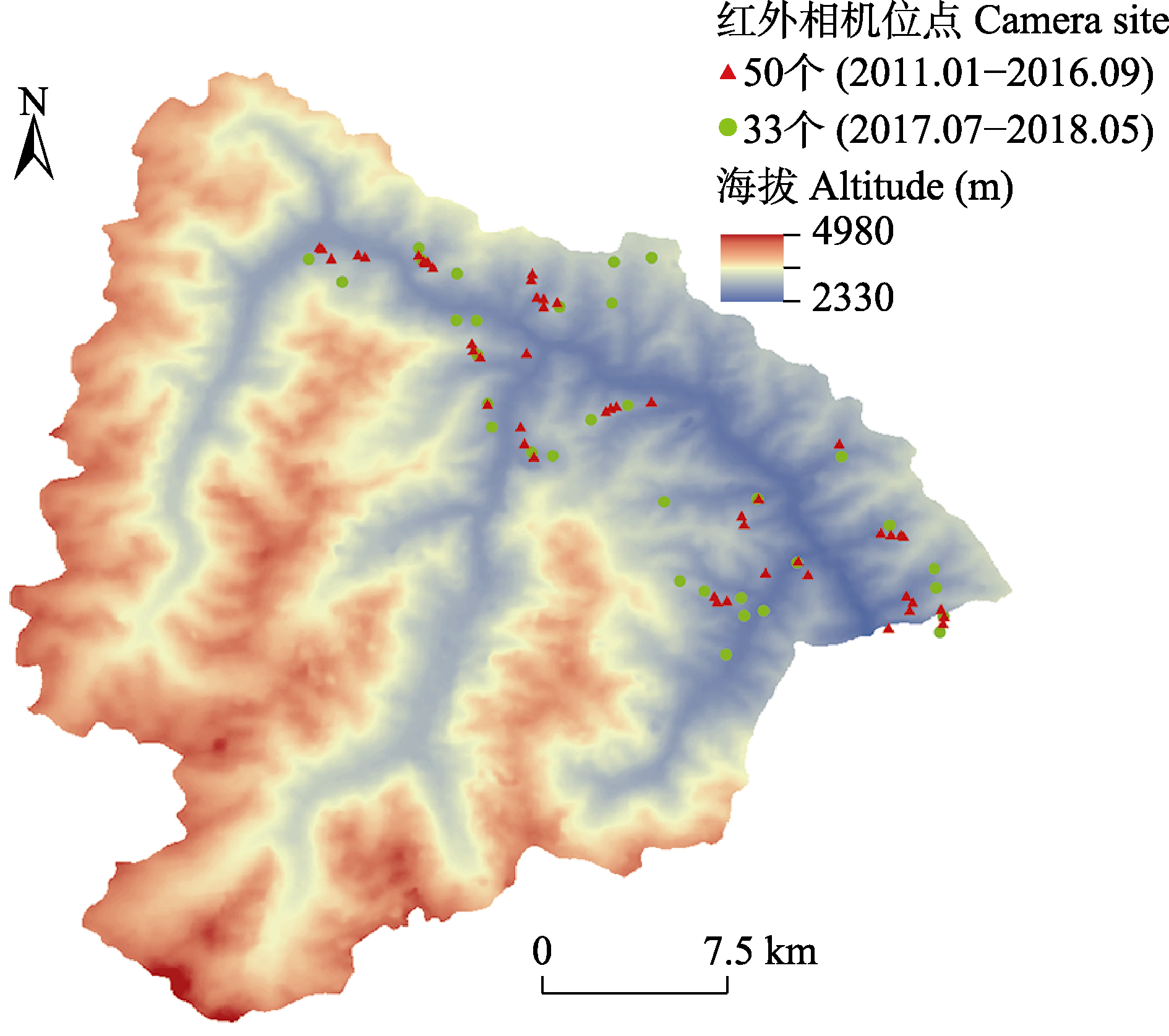
图1 王朗国家级自然保护区红外相机布设位点
Fig. 1 Infrared camera sites in Wanglang National Nature Reserve
| 编号 Number | 代码 Code | 变量 Variable |
|---|---|---|
| 1 | bio 1 | 年均温 Annual mean temperature |
| 2 | bio 6 | 最冷月最低温 Min. temperature of coldest month |
| 3 | bio 8 | 最湿季平均温 Mean temperature of wettest quarter |
| 4 | bio 9 | 最干季平均温 Mean temperature of driest quarter |
| 5 | bio 12 | 年降水量 Annual precipitation |
| 6 | bio 13 | 最湿月降水量 Precipitation of wettest month |
| 7 | Altitude | 海拔 Altitude |
| 8 | Aspect | 坡向 Aspect |
| 9 | Slope | 坡度 Slope |
| 10 | NDVI | 归一化植被指数 Normalized difference vegetation index |
表1 10种用于建模的环境要素
Table 1 10 environmental elements used for modelling
| 编号 Number | 代码 Code | 变量 Variable |
|---|---|---|
| 1 | bio 1 | 年均温 Annual mean temperature |
| 2 | bio 6 | 最冷月最低温 Min. temperature of coldest month |
| 3 | bio 8 | 最湿季平均温 Mean temperature of wettest quarter |
| 4 | bio 9 | 最干季平均温 Mean temperature of driest quarter |
| 5 | bio 12 | 年降水量 Annual precipitation |
| 6 | bio 13 | 最湿月降水量 Precipitation of wettest month |
| 7 | Altitude | 海拔 Altitude |
| 8 | Aspect | 坡向 Aspect |
| 9 | Slope | 坡度 Slope |
| 10 | NDVI | 归一化植被指数 Normalized difference vegetation index |
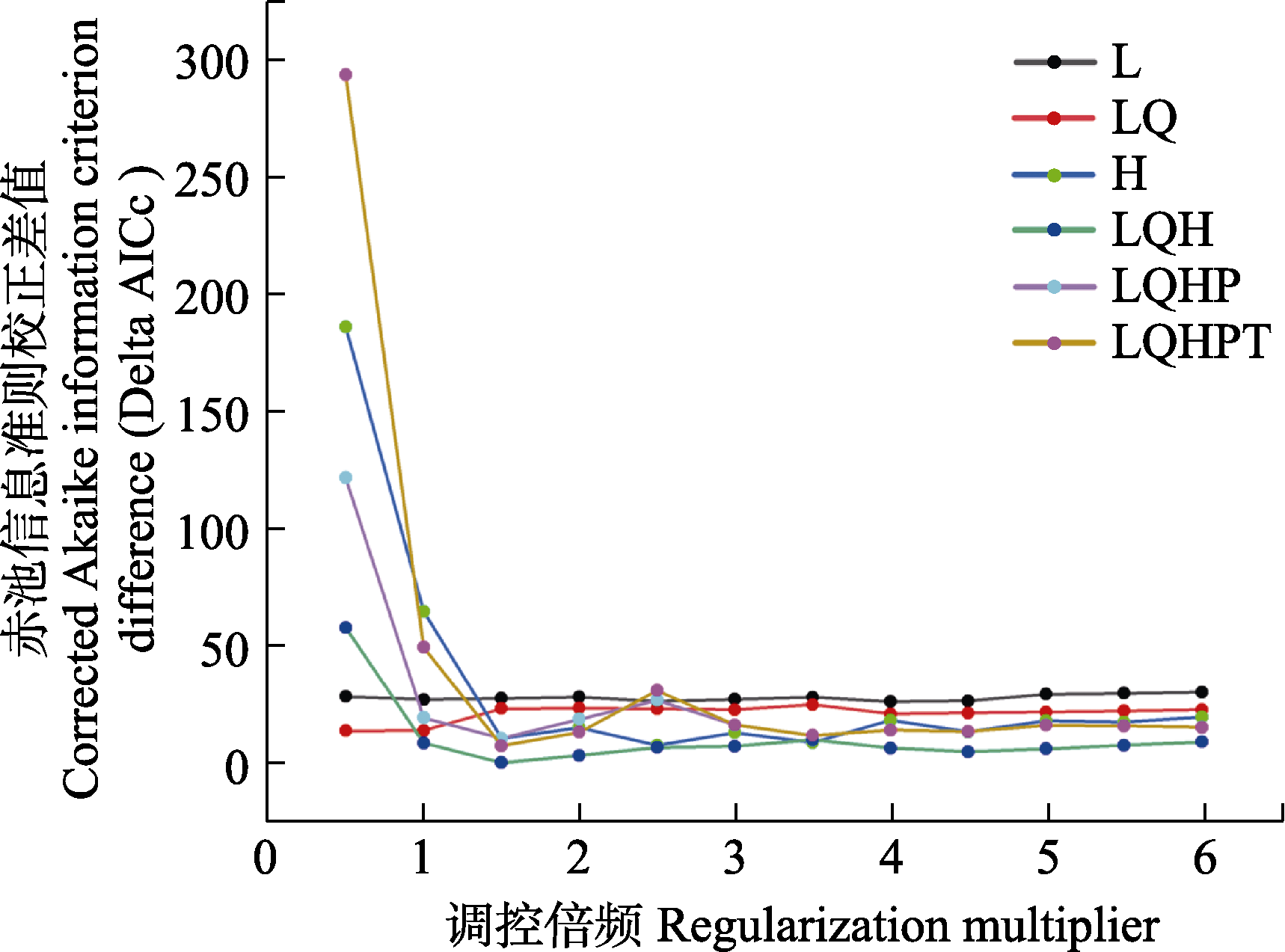
图2 基于R软件ENMeval包的MaxEnt模型优化结果。L:线型特征; Q: 二次型特征; H: 片段型特征; P: 乘积型特征; T: 阈值型特征。
Fig. 2 Optimization results of the MaxEnt model based on ENMeval. L, Linear feature; Q, Quadratic feature; H, Hinge feature; P, Product feature; T, Threshold feature.
| 环境要素 Environmental factor | 贡献率 Contribution rate (%) |
|---|---|
| 归一化植被指数 Normalized difference vegetation index (NDVI) | 63.0 |
| 年降水量 Annual precipitation (bio 12) | 16.0 |
| 最干季平均温 Mean temperature of driest quarter (bio 9) | 5.7 |
| 坡向 Aspect (Aspect) | 4.8 |
| 坡度 Slope (Slope) | 3.3 |
| 海拔 Altitude (Altitude) | 3.1 |
| 最湿季平均温 Mean temperature of wettest quarter (bio 8) | 1.6 |
| 最湿月降水量 Precipitation of wettest month (bio 13) | 0.9 |
| 最冷月最低温 Min. temperature of coldest month (bio 6) | 0.8 |
| 年均温 Annual mean temperature (bio 1) | 0.7 |
表2 最大熵模型结果中各环境要素的贡献率
Table 2 Contributions of each environmental factor in the results of MaxEnt model
| 环境要素 Environmental factor | 贡献率 Contribution rate (%) |
|---|---|
| 归一化植被指数 Normalized difference vegetation index (NDVI) | 63.0 |
| 年降水量 Annual precipitation (bio 12) | 16.0 |
| 最干季平均温 Mean temperature of driest quarter (bio 9) | 5.7 |
| 坡向 Aspect (Aspect) | 4.8 |
| 坡度 Slope (Slope) | 3.3 |
| 海拔 Altitude (Altitude) | 3.1 |
| 最湿季平均温 Mean temperature of wettest quarter (bio 8) | 1.6 |
| 最湿月降水量 Precipitation of wettest month (bio 13) | 0.9 |
| 最冷月最低温 Min. temperature of coldest month (bio 6) | 0.8 |
| 年均温 Annual mean temperature (bio 1) | 0.7 |
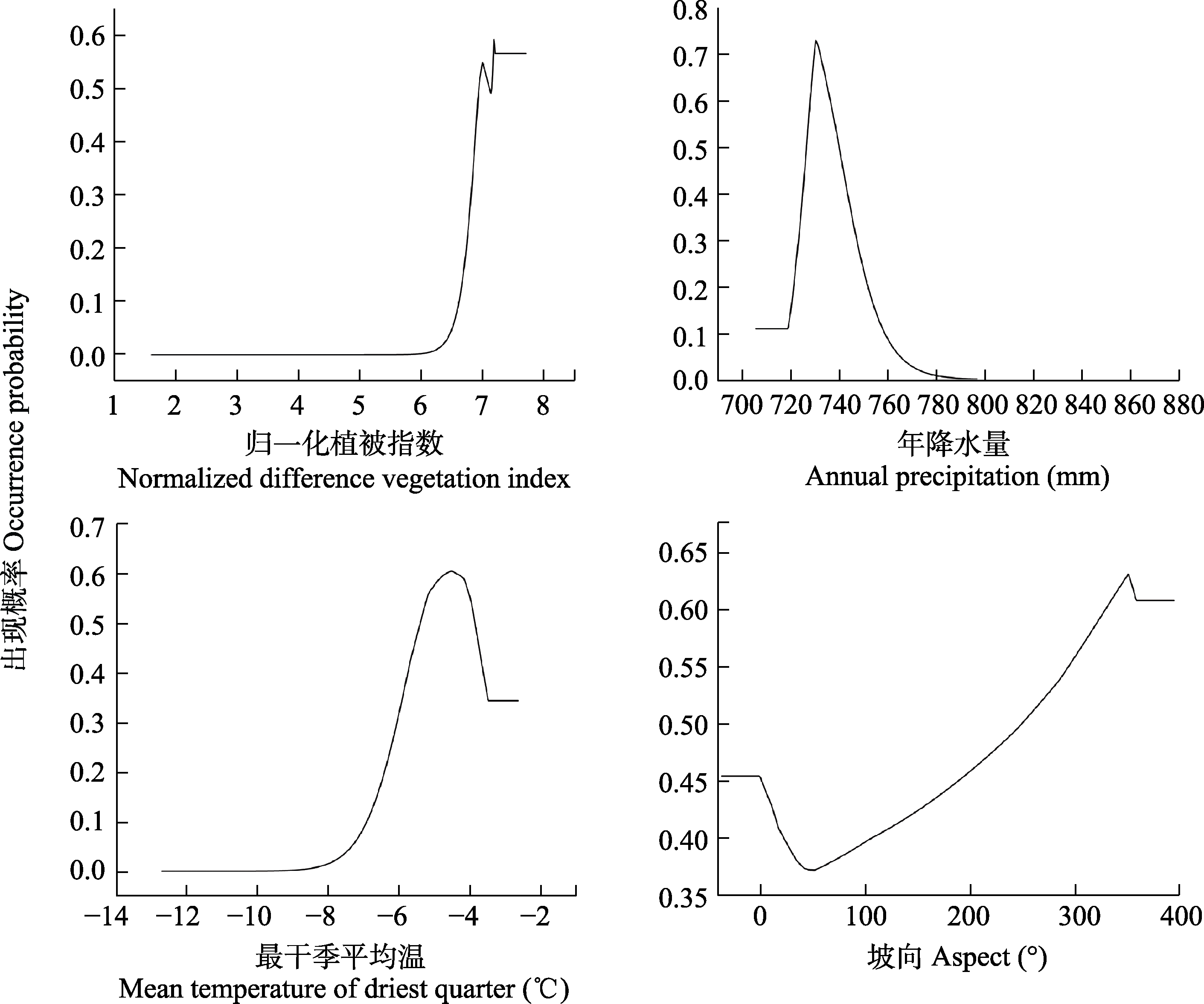
图3 主要变量的响应曲线
Fig. 3 Response curves of the main variables
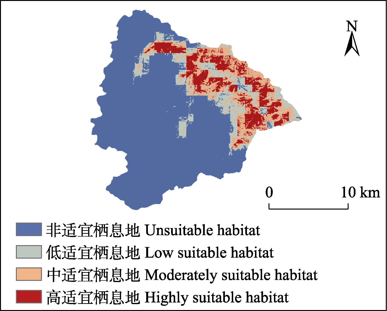
图4 红腹角雉适宜栖息地分布图
Fig. 4 Distribution of suitable habitats of Tragopan temminckii
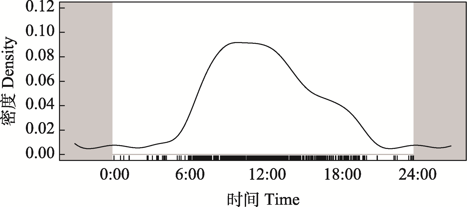
图5 红腹角雉日活动节律
Fig. 5 Daily activity rhythm of Tragopan temminckii
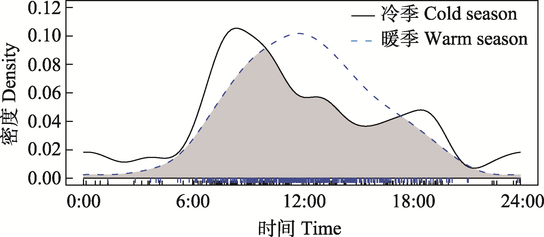
图6 红腹角雉不同季节日活动节律对比
Fig. 6 Comparison of the daily activity rhythms of Tragopan temminckii in different seasons
| [1] | Amstrup SC, Beecham J (1976) Activity patterns of radio-collared black bears in Idaho. The Journal of Wildlife Management, 40, 340-348. |
| [2] | Behdarvand N, Kaboli M, Ahmadi M, Nourani E, Mahini AS, Aghbolaghi MA (2014) Spatial risk model and mitigation implications for wolf-human conflict in a highly modified agroecosystem in western Iran. Biological Conservation, 177, 156-164. |
| [3] | Bu HL, Wang F, McShea WJ, Lu Z, Wang DJ, Li S (2016) Spatial co-occurrence and activity patterns of mesocarnivores in the temperate forests of southwest China. PLoS ONE, 11, e0164271. |
| [4] | Chang AX, Wu T, Li BW, Jiao DZ, Wang YS, He D, Jiang ZH, Fan ZY (2024) Distribution pattern of species richness of endemic genera in mountainous areas of southwest China and its influencing factors. Sustainability, 16, 3750. |
| [5] | Chen LJ, Shu ZF, Xiao ZS (2019) Application of camera- trapping data to study daily activity patterns of Galliformes in Guangdong Chebaling National Nature Reserve. Biodiversity Science, 27, 266-272. (in Chinese with English abstract) |
|
[陈立军, 束祖飞, 肖治术 (2019) 应用红外相机数据研究动物活动节律——以广东车八岭保护区鸡形目鸟类为例. 生物多样性, 27, 266-272.]
DOI |
|
| [6] | Chen MT, Tewes ME, Pei KJ, Grassman LI (2009) Activity patterns and habitat use of sympatric small carnivores in southern Taiwan. Mammalia, 73, 20-26. |
| [7] | Chen X, Zhang L (2023) Advance on wildlife habitat restoration: Bibliometric analysis. Journal of Beijing Normal University (Natural Science), 59, 575-583. (in Chinese with English abstract) |
| [陈星, 张立 (2023) 野生动物栖息地恢复研究进展及展望——基于文献计量数据分析. 北京师范大学学报(自然科学版), 59, 575-583.] | |
| [8] | Cong PH, Zheng GM (2008) The roosting behavior and roost-site selection of Temminck’s Tragopan (Tragopan temminckii) in Laojunshan Natural Reserve, Sichuan, China. Biodiversity Science, 16, 332-338. (in Chinese with English abstract) |
|
[丛培昊, 郑光美 (2008) 四川老君山地区红腹角雉的夜栖行为和夜栖地选择. 生物多样性, 16, 332-338.]
DOI |
|
| [9] | Ding P, Zhang ZW, Liang W, Li XT (2019) Forest Birds in China. Hunan Science & Technology Press, Changsha. (in Chinese) |
| [丁平, 张正旺, 梁伟, 李湘涛 (2019) 中国森林鸟类. 湖南科学技术出版社, 长沙.] | |
| [10] | Feng X, Hu Q, Shi XG, Wang ML, Qu CM, Jin SL (2021) Study on suitable habitat and activity rhythm of Tragopan temminckii in Wolong National Nature Reserve. Journal of Sichuan Forestry Science and Technology, 42(4), 12-19. (in Chinese with English abstract) |
| [冯茜, 胡强, 施小刚, 王茂麟, 瞿春茂, 金森龙 (2021) 卧龙国家级自然保护区红腹角雉适宜栖息地与活动节律研究. 四川林业科技, 42(4), 12-19.] | |
| [11] | Gaudiano L, Pucciarelli L, Mori E (2021) Livestock grazing affects movements and activity pattern of Italian roe deer in Southern Italy. European Journal of Wildlife Research, 67, 66. |
| [12] | Ge ZW, Xing W, Li JQ, Yang WY (2006) The impact of firewood collection by local people on the distributing of arbors around the nature reserves: A case study in Wanglang Nature Reserve for giant panda (Sichuan). Acta Ecologica Sinica, 26, 97-103. (in Chinese with English abstract) |
| [葛之葳, 邢玮, 李俊清, 杨伟勇 (2006) 保护区周边居民薪柴采集对乔木分布的影响——以四川王朗大熊猫自然保护区为例. 生态学报, 26, 97-103.] | |
| [13] |
Guisan A, Thuiller W (2005) Predicting species distribution: Offering more than simple habitat models. Ecology Letters, 8, 993-1009.
DOI PMID |
| [14] | Hu XG, Jin YQ, Wang XR, Mao JF, Li Y (2015) Predicting impacts of future climate change on the distribution of the widespread conifer Platycladus orientalis. PLoS ONE, 10, e0132326. |
| [15] | Jiang Y, Li DW, Liao B, Pu YB, Li XH, Lan LD (2009) Floristic analysis of seed plants in Wanglang Nature Reserve. Journal of Sichuan Forestry Science and Technology, 30(6), 93-97. (in Chinese with English abstract) |
| [蒋勇, 李德文, 廖波, 蒲永波, 李兴红, 兰立达 (2009) 王朗自然保护区种子植物及其区系特征. 四川林业科技, 30(6), 93-97.] | |
| [16] | Kang DW, Li JQ (2016) Premature downgrade of panda’s status. Science, 354, 295. |
| [17] |
Kay SL, Fischer JW, Monaghan AJ, Beasley JC, Boughton R, Campbell TA, Cooper SM, Ditchkoff SS, Hartley SB, Kilgo JC, Wisely SM, Wyckoff AC, VerCauteren KC, Pepin KM (2017) Quantifying drivers of wild pig movement across multiple spatial and temporal scales. Movement Ecology, 5, 14.
DOI PMID |
| [18] | Layola MR, Semwal M, Rana TS, Nair NK (2022) Predicting potential suitable habitat for Ensete glaucum (Roxb.) Cheesman using MaxEnt modelling. Flora, 287, 152007. |
| [19] |
Li S, Wang DJ, Xiao ZS, Li XH, Wang TM, Feng LM, Wang Y (2014) Camera-trapping in wildlife research and conservation in China: Review and outlook. Biodiversity Science, 22, 685-695. (in Chinese with English abstract)
DOI |
|
[李晟, 王大军, 肖治术, 李欣海, 王天明, 冯利民, 王云 (2014) 红外相机技术在我国野生动物研究与保护中的应用与前景. 生物多样性, 22, 685-695.]
DOI |
|
| [20] | Li SQ, Liao GJ, Meng QY, He F, Peng B, Fu Y, Lei XJ, Ren TT (2024) Spatial distribution pattern of Tragopan temminckii in Xiaozhaizigou National Nature Reserve, Sichuan Province. Journal of Sichuan Forestry Science and Technology, 45(5), 68-75. (in Chinese with English abstract) |
| [李生强, 廖光炯, 孟庆玉, 贺飞, 彭波, 伏勇, 雷小军, 任婷婷 (2024) 四川小寨子沟国家级自然保护区红腹角雉空间分布格局. 四川林业科技, 45(5), 68-75.] | |
| [21] | Liu CR, White M, Newell G (2013) Selecting thresholds for the prediction of species occurrence with presence-only data. Journal of Biogeography, 40, 778-789. |
| [22] | Liu K, Liu YL, Li S (2023) The current distribution and prediction of suitable habitat of Eurasian lynx (Lynx lynx) in China. Acta Theriologica Sinica, 43, 652-663. (in Chinese with English abstract) |
|
[刘轲, 刘炎林, 李晟 (2023) 欧亚猞猁在中国的分布现状与适宜栖息地预测. 兽类学报, 43, 652-663.]
DOI |
|
| [23] | Liu Q, Hu YF (2022) Study on vegetation dynamics in Wanglang National Nature Reserve based on RS and GIS. Journal of Sichuan Agricultural University, 40, 907-912. (in Chinese with English abstract) |
| [刘强, 胡玉福 (2022) 基于RS和GIS的王朗国家级自然保护区植被动态研究. 四川农业大学学报, 40, 907-912.] | |
| [24] | Liu SY, Qi JZ, Gu JY, Long ZX, Ma JZ, Jiang GS (2021) What factors relate with the activity synchronization intensity among big cats and their ungulate prey in Northeast China? Global Ecology and Conservation, 32, e01899. |
| [25] | Liu SY, Wu Y, Li S (2019) Illustrated Handbook of Chinese Mammals. Strait Publishing House, Fuzhou. (in Chinese) |
| [刘少英, 吴毅, 李晟 (2019) 中国兽类图鉴. 海峡书局, 福州.] | |
| [26] | Liu XB, Wei W, Zheng XG, Zhao KH, He SW, Zhou WL (2017) Activity rhythms of golden pheasant (Chrysolophus pictus) and satyr tragopan (Tragopan temminckii) revealed by infrared-triggered cameras. Chinese Journal of Zoology, 52, 194-202. (in Chinese with English abstract) |
| [刘小斌, 韦伟, 郑筱光, 赵凯辉, 何少文, 周文良 (2017) 红腹锦鸡和红腹角雉活动节律——基于红外相机监测数据. 动物学杂志, 52, 194-202.] | |
| [27] | Lynam AJ, Jenks KE, Tantipisanuh N, Chutipong W, Ngoprasert D, Gale GA, Steinmetz R, Sukmasuang R, Bhumpakphan N, Grassman LI, Cutter P, Kitamura S, Reed DH, Baker MC, McShea W, Songsasen N, Leimgruber P (2013) Terrestrial activity patterns of wild cats from camera-trapping. Raffles Bulletin of Zoology, 61, 407-415. |
| [28] | Mahmoodi S, Ahmadi K, Shabani AA, Zeinalabedini M, Javanmard A, Khalilipour O, Banabazi MH (2023) Anthropogenic and natural fragmentations shape the spatial distribution and genetic diversity of roe deer in the marginal area of its geographic range. Ecological Indicators, 154, 110835. |
| [29] | Meredith M, Ridout M (2013) Overlap: Estimates of coefficient of overlapping for animal activity patterns. https://CRAN.R-project.org/package=overlap. (accessed on 2025-05-07) |
| [30] |
Mori E, Bagnato S, Serroni P, Sangiuliano A, Rotondaro F, Marchianò V, Cascini V, Poerio L, Ferretti F (2020) Spatiotemporal mechanisms of coexistence in an European mammal community in a protected area of southern Italy. Journal of Zoology, 310, 232-245.
DOI |
| [31] | Muscarella R, Galante PJ, Soley-Guardia M, Boria RA, Kass JM, Uriarte M, Anderson RP (2014) ENMeval: An R package for conducting spatially independent evaluations and estimating optimal model complexity for MaxEnt ecological niche models. Methods in Ecology and Evolution, 5, 1198-1205. |
| [32] | Norberg A, Abrego N, Blanchet FG, Adler FR, Anderson BJ, Anttila J, Araújo MB, Dallas T, Dunson D, Elith J, Foster SD, Fox R, Franklin J, Godsoe W, Guisan A, O’Hara B, Hill NA, Holt RD, Hui FKC, Husby M, Kålås JA, Lehikoinen A, Luoto M, Mod HK, Newell G, Renner I, Roslin T, Soininen J, Thuiller W, Vanhatalo J, Warton D, White M, Zimmermann NE, Gravel D, Ovaskainen O (2019) A comprehensive evaluation of predictive performance of 33 species distribution models at species and community levels. Ecological Monographs, 89, e01370. |
| [33] | O’Brien TG, Kinnaird MF, Wibisono HT (2003) Crouching tigers, hidden prey: Sumatran tiger and prey populations in a tropical forest landscape. Animal Conservation, 6, 131-139. |
| [34] | Pan QH, Wang YX, Yan K (2007) A Field Guide to the Mammals of China. China Forestry Publishing House, Beijing. (in Chinese) |
| [潘清华, 王应祥, 岩崑 (2007) 中国哺乳动物彩色图鉴. 中国林业出版社, 北京.] | |
| [35] | Petridou M, Benson JF, Gimenez O, Kati V (2023) Spatiotemporal patterns of wolves, and sympatric predators and prey relative to human disturbance in northwestern Greece. Diversity, 15, 184. |
| [36] | Phillips SJ, Anderson RP, Dudík M, Schapire RE, Blair ME (2017) Opening the black box: An open-source release of MaxEnt. Ecography, 40, 887-893. |
| [37] | Ranjitkar S, Xu JC, Shrestha KK, Kindt R (2014) Ensemble forecast of climate suitability for the trans-Himalayan Nyctaginaceae species. Ecological Modelling, 282, 18-24. |
| [38] | Rhoden CM, Peterman WE, Taylor CA (2017) MaxEnt-directed field surveys identify new populations of narrowly endemic habitat specialists. PeerJ, 5, e3632. |
| [39] | Ridout MS, Linkie M (2009) Estimating overlap of daily activity patterns from camera trap data. Journal of Agricultural, Biological, and Environmental Statistics, 14, 322-337. |
| [40] | Saupe EE, Qiao HJ, Hendricks JR, Portell RW, Hunter SJ, Soberón J, Lieberman BS (2015) Niche breadth and geographic range size as determinants of species survival on geological time scales. Global Ecology and Biogeography, 24, 1159-1169. |
| [41] | Schmid F, Schmidt A (2006) Nonparametric estimation of the coefficient of overlapping—Theory and empirical application. Computational Statistics & Data Analysis, 50, 1583-1596. |
| [42] | Shi HT, Zheng GM (1998) The study on diet of Temminck’s tragopan. Zoological Research, 19, 50-54. (in Chinese with English abstract) |
| [史海涛, 郑光美 (1998) 红腹角雉的食性研究. 动物学研究, 19, 50-54.] | |
| [43] | Simpson M, Prots B (2013) Predicting the distribution of invasive plants in the Ukrainian Carpathians under climatic change and intensification of anthropogenic disturbances: Implications for biodiversity conservation. Environmental Conservation, 40, 167-181. |
| [44] | Sun RY (1992) Principles of Animal Ecology. Beijing Normal University Publishing Group, Beijing. (in Chinese) |
| [孙儒泳 (1992) 动物生态学原理. 北京师范大学出版社, 北京.] | |
| [45] | Teng Y, Zhang Z, Zhang SL, Yang YX, He W, Wang N, Zhang ZY, Bao WD (2022) Habitat suitability analysis and ecological corridor designs for red deer (Cervus elaphus) in the southern Greater Khingan Mountains. Acta Ecologica Sinica, 42, 5990-6000. (in Chinese with English abstract) |
| [滕扬, 张沼, 张书理, 杨永昕, 贺伟, 王娜, 张正一, 鲍伟东 (2022) 大兴安岭南段马鹿生境适宜性分析与生态廊道构建. 生态学报, 42, 5990-6000.] | |
| [46] | The Editorial Board of Physical Geography of China, Chinese Academy of Sciences (1979) Physical Geography of China (Zoogeography). Science Press, Beijing. (in Chinese) |
| [中国科学院《中国自然地理》编辑委员会 (1979) 中国自然地理(动物地理). 科学出版社, 北京.] | |
| [47] | Tian C (2020) Study on Spatial-temporal Distribution and Driving Factors of Wildlife in Habitat of Giant Pandas. PhD dissertation, Beijing Forestry University, Beijing. (in Chinese with English abstract) |
| [田成 (2020) 大熊猫栖息地野生动物时空分布及驱动因素研究. 博士学位论文, 北京林业大学, 北京.] | |
| [48] | Tian XM, Ji XY, Wang XX, Zhang ZD, Chen H, Liu XH, Liu L, Wang QF, Ma YH, Qian XY, Zhou SC, Ju D (2024) Habitat suitability and activity patterns of roe deer in Beijicun National Nature Reserve, Heilongjiang Province, China. Acta Ecologica Sinica, 44, 8175-8184. (in Chinese with English abstract) |
| [田新民, 汲旭阳, 王鑫雪, 张子栋, 陈红, 刘小慧, 刘磊, 王启蕃, 马雨含, 钱昕玥, 周绍春, 鞠丹 (2024) 北极村国家级自然保护区狍栖息地适宜性及活动节律. 生态学报, 44, 8175-8184.] | |
| [49] | Wan XR, Wang MJ, Liu W, Wang GH, Zhong WQ (2002) Numerical indices for evaluating the activity patterns of rodent species. Acta Theriologica Sinica, 22, 211-217. (in Chinese with English abstract) |
| [宛新荣, 王梦军, 刘伟, 王广和, 钟文勤 (2002) 啮齿动物活动模式的几种数值指标. 兽类学报, 22, 211-217.] | |
| [50] | Wang B, Xu Y, Ran JH (2017) Predicting suitable habitat of the Chinese monal (Lophophorus lhuysii) using ecological niche modeling in the Qionglai Mountains, China. PeerJ, 5, e3477. |
| [51] | Wang JF, Xu JL, Li JQ, Zhou CF, Deng WH (2022) Assess the conservation effectiveness of the natural protected areas in Beijing based on the suitable habitat of wild animals. Acta Ecologica Sinica, 42, 7807-7817. (in Chinese with English abstract) |
| [王金凤, 徐基良, 李建强, 周春发, 邓文洪 (2022) 基于动物适宜栖息地的北京市自然保护地保护成效评估. 生态学报, 42, 7807-7817.] | |
| [52] | Wang JH, Qian QF, Zhang FY, Jia XJ, He JQ (2022) The possible future changes in potential suitable habitats of Tetrastigma hemsleyanum (Vitaceae) in China predicted by an ensemble model. Global Ecology and Conservation, 35, e02083. |
| [53] | Wang MJ, Li JQ (2008) Research on habitat restoration of giant panda after a grave disturbance of earthquake in Wanglang Nature Reserve, Sichuan Province. Acta Ecologica Sinica, 28, 5848-5855. (in Chinese with English abstract) |
| [王梦君, 李俊清 (2008) 四川省王朗自然保护区地震干扰后大熊猫栖息地的恢复. 生态学报, 28, 5848-5855.] | |
| [54] | Wang P, Li YJ, Yuan JG, Geng P, Li R (2023) Habitat suitability assessment for Moschus moschiferus based on optimized MaxEnt model. Chinese Journal of Wildlife, 44, 38-45. (in Chinese with English abstract) |
| [王佩, 李英杰, 袁家根, 耿盼, 李蕊 (2023) 基于优化MaxEnt模型的原麝生境适宜性评价. 野生动物学报, 44, 38-45.] | |
| [55] | Wei FW, Yang QS, Wu Y, Jiang XL, Liu SY, Li BG, Yang G, Li M, Zhou J, Li S, Hu YB, Ge DY, Li S, Yu WH, Chen BY, Zhang ZJ, Zhou CQ, Wu SB, Zhang L, Chen ZZ, Chen SD, Deng HQ, Jiang TL, Zhang LB, Shi HY, Lu XL, Li Q, Liu Z, Cui YQ, Li YC (2021) Catalogue of mammals in China (2021). Acta Theriologica Sinica, 41, 487-501. (in Chinese with English abstract) |
|
[魏辅文, 杨奇森, 吴毅, 蒋学龙, 刘少英, 李保国, 杨光, 李明, 周江, 李松, 胡义波, 葛德燕, 李晟, 余文华, 陈炳耀, 张泽钧, 周材权, 吴诗宝, 张立, 陈中正, 陈顺德, 邓怀庆, 江廷磊, 张礼标, 石红艳, 卢学理, 李权, 刘铸, 崔雅倩, 李玉春 (2021) 中国兽类名录(2021版). 兽类学报, 41, 487-501.]
DOI |
|
| [56] | Wilson JW, Sexton JO, Todd Jobe R, Haddad NM (2013) The relative contribution of terrain, land cover, and vegetation structure indices to species distribution models. Biological Conservation, 164, 170-176. |
| [57] | Xia SS, Hu DM, Deng Y, Zhong X, Bai WK, Zhang JD, Wang B, Zhou CQ (2019) Habitat partitioning between sympatric golden pheasant and Temminck’s tragopan at different spatial scales. Acta Ecologica Sinica, 39, 1627-1638. (in Chinese with English abstract) |
| [夏珊珊, 胡大明, 邓玥, 钟雪, 白文科, 张晋东, 王彬, 周材权 (2019) 同域分布红腹锦鸡和红腹角雉在不同空间尺度下的生境分化. 生态学报, 39, 1627-1638.] | |
| [58] |
Xing C, Lin Y, Zhou ZQ, Zhao LJ, Jiang SW, Lin ZZ, Xu JL, Zhan XJ (2023) The establishment of terrestrial vertebrate genetic resource bank and species identification based on DNA barcoding in Wanglang National Nature Reserve. Biodiversity Science, 31, 22661. (in Chinese with English abstract)
DOI |
|
[邢超, 林依, 周智强, 赵联军, 蒋仕伟, 林蓁蓁, 徐基良, 詹祥江 (2023) 基于DNA条形码技术构建王朗国家级自然保护区陆生脊椎动物遗传资源数据库及物种鉴定. 生物多样性, 31, 22661.]
DOI |
|
| [59] | Xu Y, Liu SD, Li YJ, Liu ZX, Yu B, Jiang WL, Zheng Y, Qing L (2023) Influence of habitat on the activity intensity of dominant species in Wanglang Nature Reserve. Journal of Sichuan Forestry Science and Technology, 44(5), 15-23. (in Chinese with English abstract) |
| [许阳, 刘世达, 李英洁, 刘正霄, 余冰, 蒋文龙, 郑勇, 卿莉 (2023) 生境对王朗自然保护区内优势种活动强度影响. 四川林业科技, 44(5), 15-23.] | |
| [60] | Xu ZL, Zhao CY, Feng ZD (2009) A study of the impact of climate change on the potential distribution of Qinghai spruce (Picea crassifolia) in Qilian Mountains. Acta Ecologica Sinica, 29, 278-285. |
| [61] | Xue JR, Su BF (2017) Significant remote sensing vegetation indices: A review of developments and applications. Journal of Sensors, 2017, 1353691. |
| [62] | Yuan FK, Li YK, Li FS, Li J, Miao LJ, Xie GY (2014) The influence of age, flock size, habitat, and weather on the time budget and the daily rhythm of wintering Siberian cranes in Poyang Lake. Acta Ecologica Sinica, 34, 2608-2616. (in Chinese with English abstract) |
| [袁芳凯, 李言阔, 李凤山, 李佳, 缪泸君, 谢光勇 (2014) 年龄、集群、生境及天气对鄱阳湖白鹤越冬期日间行为模式的影响. 生态学报, 34, 2608-2616.] | |
| [63] |
Zhao CG, Chen F, Yan ZK, Liu XY, Liu LM, Li WW, Duan YB (2021) Activity rhythm and interspecific association of sympatric lady Amherst’s pheasant and Temminck’s tragopan in the Yaoshan Mountains. Chinese Journal of Ecology, 40, 4008-4014. (in Chinese with English abstract)
DOI |
| [赵晨光, 陈飞, 颜再奎, 刘兴元, 刘鲁明, 李维薇, 段玉宝 (2021) 同域分布的白腹锦鸡和红腹角雉的活动节律及种间联结关系. 生态学杂志, 40, 4008-4014.] | |
| [64] | Zheng GM (2004) Research progress on ecology of endangered pheasants in China. Bulletin of Biology, 39(1), 1-3. (in Chinese) |
| [郑光美 (2004) 中国濒危雉类生态学研究进展. 生物学通报, 39(1), 1-3.] | |
| [65] | Zheng GM (2005) A Checklist on the Classification and Distribution of the Birds of China. Science Press, Beijing. (in Chinese) |
| [郑光美 (2005) 中国鸟类分类与分布名录. 科学出版社, 北京.] | |
| [66] | Zhu GP, Qiao HJ (2016) Effect of the MaxEnt model’s complexity on the prediction of species potential distributions. Biodiversity Science, 24, 1189-1196. (in Chinese with English abstract) |
|
[朱耿平, 乔慧捷 (2016) MaxEnt模型复杂度对物种潜在分布区预测的影响. 生物多样性, 24, 1189-1196.]
DOI |
| [1] | 王倩倩, 陈孝国, 朱锐丰, 张明春, 王新, 李世林, 仁增江措, 彭武, 杨彪. 藏东南黑麝及其同域有蹄类物种的生态适应性差异[J]. 生物多样性, 2026, 34(5): 25433-. |
| [2] | 冯杰, 李彦知, 王书理, 李岚曦, 丁鹏飞, 吕冰薇, 孟吉, 史湘莹, 李雪阳. 西南山地有蹄类栖息地利用率多年变化及环境影响: 以关坝村红外相机监测为例[J]. 生物多样性, 2026, 34(5): 25261-. |
| [3] | 孔孜亦, 王德港, 王建涛, 裴志永, 孙晶, 张长春, 张军国. 基于SCD-HRNet模型的野生动物姿态估计及其在生物多样性监测中的应用: 以内蒙古赛罕乌拉地区为例[J]. 生物多样性, 2026, 34(4): 25287-. |
| [4] | 张同, 梁力文, 王长剑, 舒服, 王璐, 郭泽光, 卓玛曲珍, 钱芊, 蒋安莉, 敖俊杰, 彭兴文, 伍小刚, 向左甫, 郭克疾, 廖梓延. 基于红外相机的西藏芒康滇金丝猴国家级自然保护区鸟兽多样性及代表性物种的季节性空间利用特征[J]. 生物多样性, 2026, 34(4): 25435-. |
| [5] | 周铝, 姚世贸, 赵战合, 郭画, 田成. 庞泉沟国家级自然保护区狍和野猪时空共存格局[J]. 生物多样性, 2026, 34(2): 25327-. |
| [6] | 岳可欣, 牛钟辉, 刘念, 徐琳, 吕韦韦, 徐茂宏, 崔绍朋. 山西历山三种同域分布食肉动物昼夜活动节律及与月光周期的关系[J]. 生物多样性, 2025, 33(9): 25084-. |
| [7] | 吉晟男, 韩佳蓉, 任月恒, 穆晓东, 朱彦鹏. 基于MaxEnt模型预测海南岛重点管理外来入侵植物适生区及其入侵风险[J]. 生物多样性, 2025, 33(8): 25037-. |
| [8] | 李基才, 邵长亮, 高帅帅, 李佳. 新疆卡拉麦里国家公园候选区蒙古野驴夏季水源利用规律、活动范围和适宜生境分布[J]. 生物多样性, 2025, 33(7): 24509-. |
| [9] | 毛静, 王婧, 黄杰, 熊姝红, 张自亮, 张佑祥, 吴涛. 湖南高望界国家级自然保护区2021-2023年鸟兽多样性监测数据集[J]. 生物多样性, 2025, 33(6): 24489-. |
| [10] | 黄定旭, 肖文宏, 白小节, 刘邦友, 黎源君, 梁盛, 肖治术, 刘伟. 赤水桫椤国家级自然保护区中小型食肉目动物昼夜活动节律的比较[J]. 生物多样性, 2025, 33(6): 24376-. |
| [11] | 罗敏, 杨永川, 靳程, 周礼华, 龙宇潇. 重庆中心城区城市森林兽类组成特征及其对人类活动的响应[J]. 生物多样性, 2025, 33(5): 24402-. |
| [12] | 龚翠凤, 韦伟, 罗概, 韩一敏, 吴鹏程, 何梦楠, 闵清悦, 付强, 陈鹏. 大熊猫国家公园崇州片区有蹄类动物空间分布及共存关系[J]. 生物多样性, 2025, 33(3): 24260-. |
| [13] | 王大伟, 程帅, 冯佳伟, 王天明. 东北地区张广才岭2015-2020年野生动物红外相机监测数据集[J]. 生物多样性, 2025, 33(2): 24384-. |
| [14] | 汪锦辉, 刘宝权, 周晓, 梁子安, 孔令伟, 方卫军, 孙晗靖, 金挺浩, 厉亮, 何珂, 朱振贤. 基于红外相机监测的杭州市鸟兽多样性分析与优先保护关键区域评估[J]. 生物多样性, 2025, 33(12): 25265-. |
| [15] | 罗怀英, 张超, 钱长江, 李剑峰, 程搏幸, 何勇, 孙悦. 圈养川金丝猴行为谱、PAE编码系统及行为节律[J]. 生物多样性, 2025, 33(10): 25133-. |
| 阅读次数 | ||||||
|
全文 |
|
|||||
|
摘要 |
|
|||||
备案号:京ICP备16067583号-7
Copyright © 2026 版权所有 《生物多样性》编辑部
地址: 北京香山南辛村20号, 邮编:100093
电话: 010-62836137, 62836665 E-mail: biodiversity@ibcas.ac.cn
![]()