
生物多样性 ›› 2025, Vol. 33 ›› Issue (7): 24509. DOI: 10.17520/biods.2024509 cstr: 32101.14.biods.2024509
李基才1,2, 邵长亮2, 高帅帅3, 李佳3,*( )(
)( )
)
收稿日期:2024-11-22
接受日期:2025-02-06
出版日期:2025-07-20
发布日期:2025-08-27
通讯作者:
*E-mail: lijia2530@126.com
基金资助:
Jicai Li1,2, Changliang Shao2, Shuaishuai Gao3, Jia Li3,*()()
Received:2024-11-22
Accepted:2025-02-06
Online:2025-07-20
Published:2025-08-27
Contact:
*E-mail: lijia2530@126.com
Supported by:摘要: 掌握蒙古野驴(Equus hemionus)活动节律、活动范围和适宜生境分布, 有助于理解蒙古野驴适应环境变化的生存策略。本研究于2021-2023年夏季(6-8月)在卡拉麦里国家公园候选区, 利用红外相机技术开展蒙古野驴夏季水源利用规律研究。于2022-2024年, 对卡拉麦里国家公园候选区野外放归的6匹蒙古野驴佩带GPS颈圈进行跟踪监测。利用GPS颈圈数据开展蒙古野驴50%和95% Kernel夏季活动范围研究。同时, 基于红外相机和GPS颈圈数据, 利用BIOMOD2物种分布模型模拟蒙古野驴夏季适宜生境分布, 并评估国家公园候选区保护空缺。结果表明: (1)安装在卡拉麦里国家公园候选区的红外相机夏季共记录到5,996张蒙古野驴独立照片。其中, 白天2,825张、夜间2,212张、清晨459张、黄昏500张; (2)蒙古野驴在夏季水源利用方面表现出全天活动强度相对稳定的特征, 为昼夜兼性动物, 夜间活动指数略高于其他时间段, 活动高峰出现在23:00至翌日04:00, 清晨和黄昏时分活动强度略低; (3) 6匹蒙古野驴夏季50% K活动范围为4.98-162.18 km2, 平均活动范围为76.34 ± 69.36 km2; 夏季95% K活动范围为27.67-2,117.72 km2, 平均活动范围为892.95 ± 908.91 km2; (4) BIOMOD2模拟结果表明, 卡拉麦里国家公园候选区蒙古野驴夏季适宜生境总面积为1.94 × 10⁴ km2, 76.97%的适宜生境处于国家公园候选区范围内。本研究初步掌握了卡拉麦里国家公园候选区蒙古野驴夏季利用水源规律、活动范围和适宜生境分布, 丰富了行为生态学知识, 可为国家公园候选区制定针对蒙古野驴及其栖息地的保护管理对策提供科学依据。
李基才, 邵长亮, 高帅帅, 李佳 (2025) 新疆卡拉麦里国家公园候选区蒙古野驴夏季水源利用规律、活动范围和适宜生境分布. 生物多样性, 33, 24509. DOI: 10.17520/biods.2024509.
Jicai Li, Changliang Shao, Shuaishuai Gao, Jia Li (2025) Summer water source utilization patterns, activity range and suitable habitat distribution of Equus hemionus in Xinjiang Kalamaili National Park candidate area. Biodiversity Science, 33, 24509. DOI: 10.17520/biods.2024509.
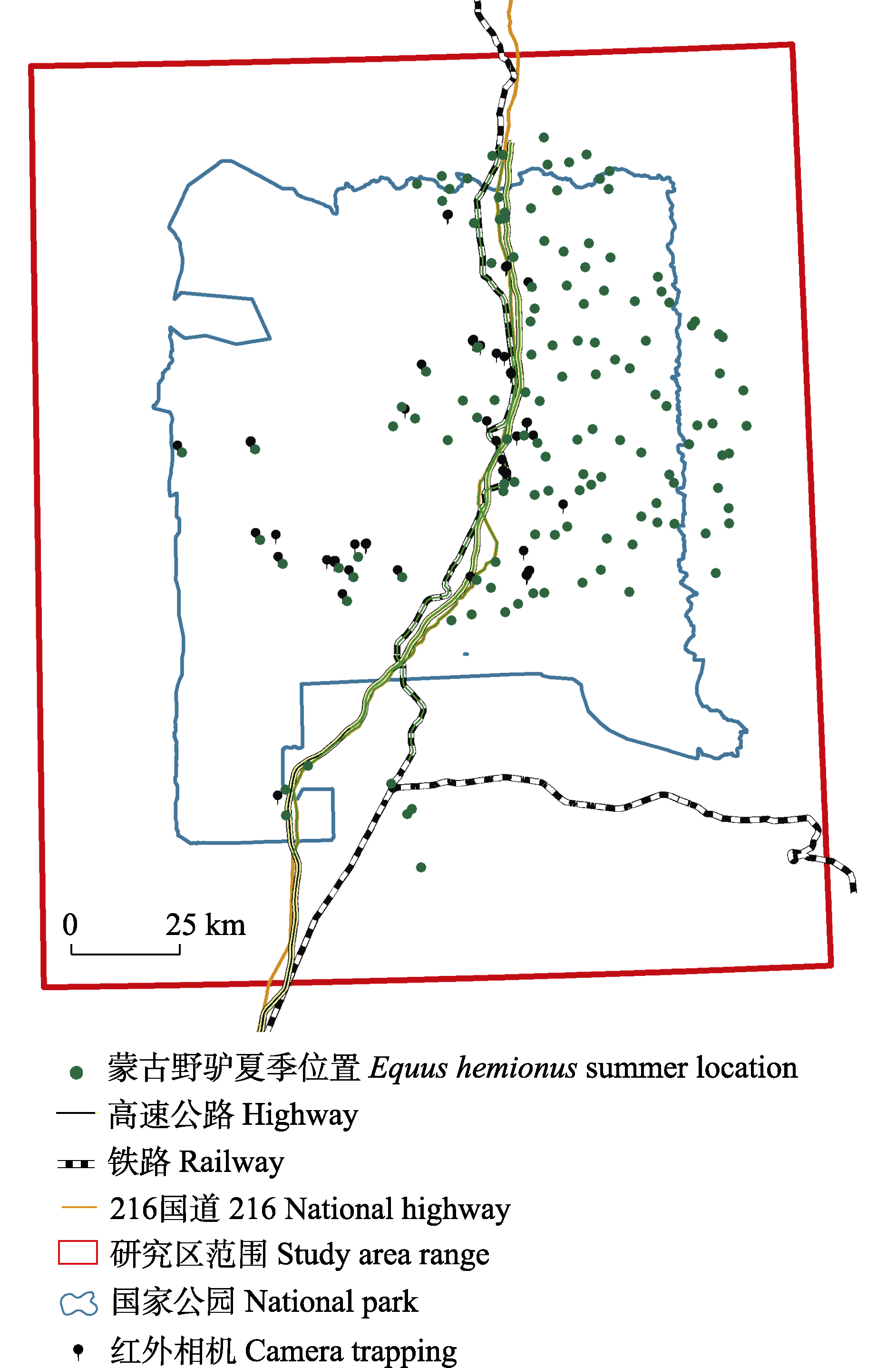
图1 新疆卡拉麦里国家公园候选区布设的红外相机点位和蒙古野驴夏季分布位置
Fig. 1 Camera trapping sites and Equus hemionus summer location in Xinjiang Kalamaili National Park candidate area
| 编号 ID | 跟踪时间 Tracking time | 工作天数 Working day | 点位数量 No. of point | 50% K活动范围 50% K activity range (km2) | 95% K活动范围 95% K activity range (km2) |
|---|---|---|---|---|---|
| No. 01 | 2023/05/09-2024/09/18 | 498 | 4,416 | 162.18 | 2,117.73 |
| No. 02 | 2022/03/12-2024/08/26 | 898 | 9,523 | 89.56 | 1,476.72 |
| No. 03 | 2022/03/12-2022/06/11 | 91 | 122 | 153.37 | 1,489.01 |
| No. 04 | 2022/03/12-2022/07/01 | 111 | 242 | 24.28 | 102.03 |
| No. 05 | 2022/03/12-2023/12/01 | 629 | 1,642 | 4.98 | 27.67 |
| No. 06 | 2022/03/12-2023/10/05 | 572 | 1,637 | 23.67 | 144.51 |
表1 卡拉麦里国家公园候选区蒙古野驴佩戴GPS颈圈点位, 以及95% Kernel和50% Kernel活动范围
Table 1 GPS collar positioning points and activity range (95% K and 50% K) of Equus hemionus in Kalamaili National Park candidate area①
| 编号 ID | 跟踪时间 Tracking time | 工作天数 Working day | 点位数量 No. of point | 50% K活动范围 50% K activity range (km2) | 95% K活动范围 95% K activity range (km2) |
|---|---|---|---|---|---|
| No. 01 | 2023/05/09-2024/09/18 | 498 | 4,416 | 162.18 | 2,117.73 |
| No. 02 | 2022/03/12-2024/08/26 | 898 | 9,523 | 89.56 | 1,476.72 |
| No. 03 | 2022/03/12-2022/06/11 | 91 | 122 | 153.37 | 1,489.01 |
| No. 04 | 2022/03/12-2022/07/01 | 111 | 242 | 24.28 | 102.03 |
| No. 05 | 2022/03/12-2023/12/01 | 629 | 1,642 | 4.98 | 27.67 |
| No. 06 | 2022/03/12-2023/10/05 | 572 | 1,637 | 23.67 | 144.51 |
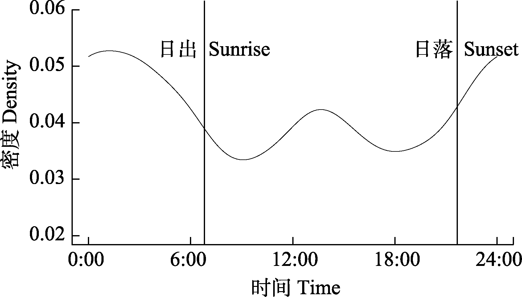
图2 卡拉麦里国家公园候选区蒙古野驴夏季水源利用规律
Fig. 2 Water resource utilization pattern of Equus hemionus during summer in Kalamaili National Park candidate area
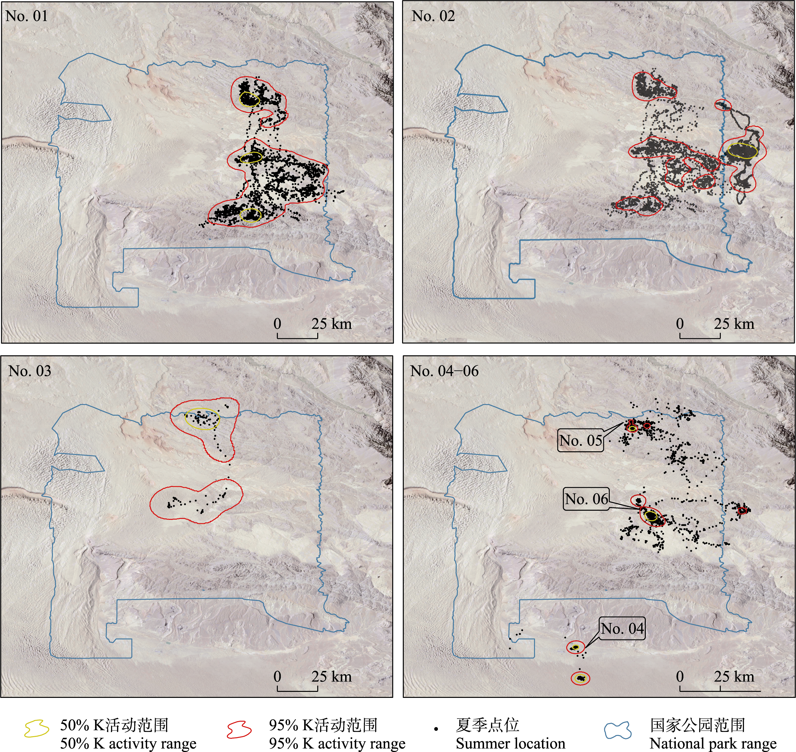
图3 卡拉麦里国家公园候选区蒙古野驴(编号No. 01-06)夏季活动范围
Fig. 3 Activity range (95% K and 50% K) of Equus hemionus (No. 01-06) in Kalamaili National Park candidate area during summer
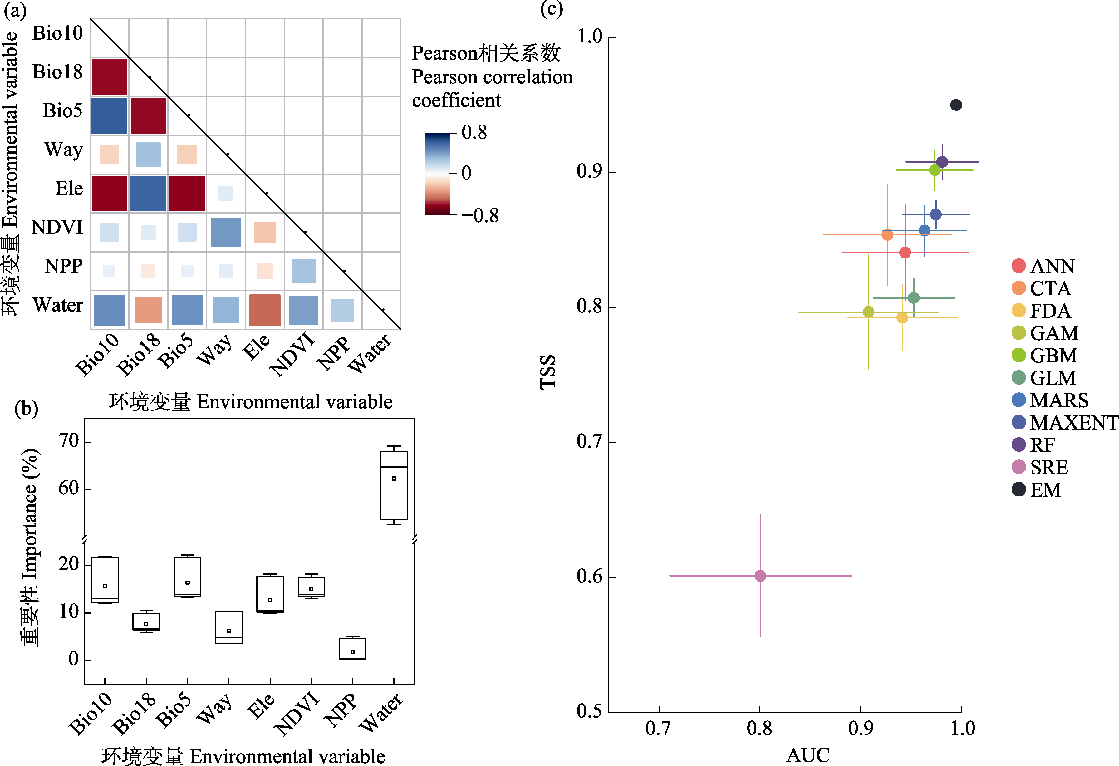
图4 卡拉麦里国家公园候选区蒙古野驴夏季环境变量之间的相关性分析(a)、对组合模型的综合贡献率(b)以及模型评估精度(c)。NPP: 净初级生产力; NDVI: 归一化植被指数; Water: 距水源点距离; Ele: 海拔; Way: 距道路距离; Bio5: 最暖月最高温; Bio10: 最暖季平均温; Bio18: 最暖月降水量; ANN: 人工神经网络模型; CTA: 分类与回归树模型; FDA: 柔性判别分析模型; GAM: 广义加法模型; GBM: 广义增强回归模型; GLM: 广义线性模型; MARS: 多元适应回归样条函数; MAXENT: 最大熵模型; RF: 随机森林; SRE: 表面分布区分室模型; EM: 组合模型; AUC: 受试者工作特征曲线下面积; TSS: 真实技巧统计值。
Fig. 4 Correlation analysis among environmental variables (a), comprehensive contribution to combine model (b), and accuracy evaluation of models (c) for Equus hemionus in Kalamaili National Park candidate area during summer. NPP, Net primary productivity; NDVI, Normalized difference vegetation index; Water, Distance to water sites; Ele, Elevation; Way, Distance to ways; Bio5, Max. temperature of warmest month; Bio10, Mean temperature of warmest quarter; Bio18, Precipitation of warmest month; ANN, Artificial neural network; CTA, Classification and regression tree analysis; FDA, Flexible discriminant analysis; GAM, Generalized addition model; GBM, Generalized boosted regression model; GLM, Generalized linear model; MARS, Multivariate adaptive regression splines; MAXENT, Maximum entropy model; RF, Random forest; SRE, Surface range envelope model; EM, Combined model; AUC, Area under the receiver operating characteristic curve; TSS, True skill statistic.
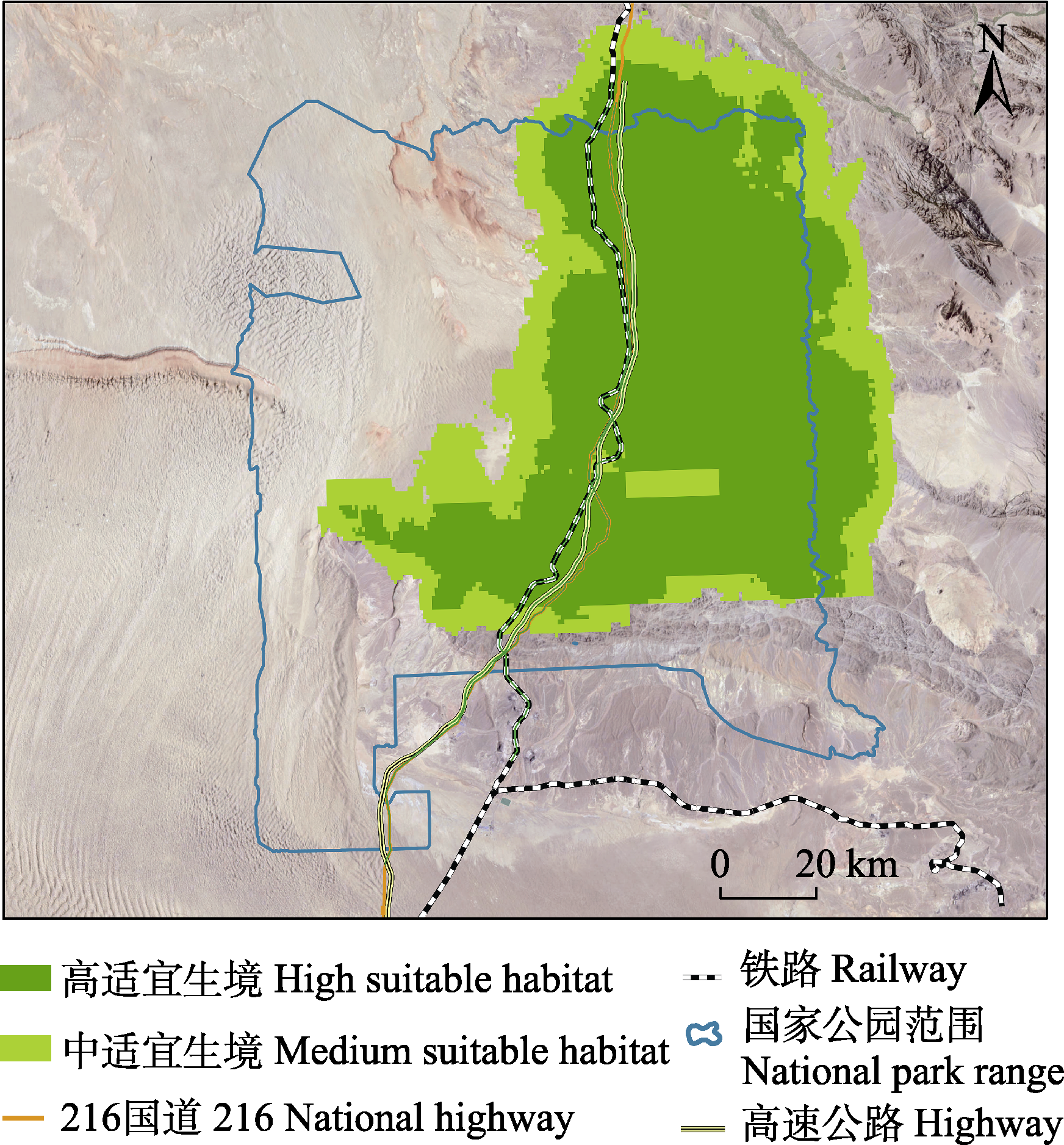
图5 卡拉麦里国家公园候选区蒙古野驴夏季适宜生境分布
Fig. 5 Suitable habitat of Equus hemionus in Kalamaili National Park candidate area during summer
| [1] | Andreoni A, Augugliaro C, Zozzoli R, Dartora F, Mori E (2021) Diel activity patterns and overlap between Eurasian red squirrels and Siberian chipmunks in native and introduced ranges. Ethology, Ecology & Evolution, 33, 83-89. |
| [2] | Buuveibaatar B, Strindberg S, Kaczensky P, Payne J, Chimeddorj B, Naranbaatar G, Amarsaikhan S, Dashnyam B, Munkhzul T, Purevsuren T, Hosack DA, Fuller TK (2017) Mongolian Gobi supports the world’s largest populations of khulan Equus hemionus and goitered gazelles Gazella subgutturosa. Oryx, 51, 639-647. |
| [3] |
Cagnacci F, Focardi S, Ghisla A, van Moorter B, Merrill EH, Gurarie E, Heurich M, Mysterud A, Linnell J, Panzacchi M, May R, Nygård T, Rolandsen C, Hebblewhite M (2016) How many routes lead to migration? Comparison of methods to assess and characterize migratory movements. Journal of Animal Ecology, 85, 54-68.
DOI PMID |
| [4] | Chen C, Shao CL, Ge Y, Wang MY, Zhang XC, Xu WX, Yang WK (2021) Habitat pattern dynamics and cause analysis of Equus hemionus in Kalamaili Mountain Ungulate Nature Reserve, Xinjiang. Acta Ecologica Sinica, 41, 2056-2066. (in Chinese with English abstract) |
| [陈晨, 邵长亮, 葛炎, 汪沐阳, 张晓晨, 徐文轩, 杨维康 (2021) 卡拉麦里山有蹄类野生动物自然保护区蒙古野驴生境格局动态及其成因分析. 生态学报, 41, 2056-2066.] | |
| [5] | Chu HJ, Jiang ZG, Ge Y, Jiang F, Tao YS, Wang C (2009) Population densities and number of khulan and goitered gazelle in Mt. Kalamaili Ungulate Nature Reserve. Biodiversity Science, 17, 414-422. (in Chinese with English abstract) |
|
[初红军, 蒋志刚, 葛炎, 蒋峰, 陶永善, 王臣 (2009) 卡拉麦里山有蹄类自然保护区蒙古野驴和鹅喉羚种群密度和数量. 生物多样性, 17, 414-422.]
DOI |
|
| [6] | Cserkész T, Kiss C, Sramkó G (2023) Seasonal and diel activity patterns of small mammal guilds on the Pannonian Steppe: A step towards a better understanding of the ecology of the endangered Hungarian birch mouse (Sicista trizona) (Sminthidae, Rodentia). Mammal Research, 68, 13-25. |
| [7] | Ding JJ, Wang Y, Koirala S, Wang MY, Xu WX, Yang WK (2024a) Factors affecting crossing structure use by khulan and goitered gazelle in China. Transportation Research Part D: Transport and Environment, 136, 104417. |
| [8] | Ding JJ, Zhuo YY, Xu WX, Kessler M, Wang MY, Yang WK (2024b) Synergistic effects of climate and land use change on khulan (Equus hemionus hemionus) habitat in China. Global Ecology and Conservation, 54, e03181. |
| [9] |
Dong TC, Chu HJ, Wu HP, Wang Y, Ge Y, Bu L (2014) Monitoring birds and mammals through camera traps in Mount Kalamaili Ungulate Nature Reserve, Xinjiang. Biodiversity Science, 22, 804-807. (in Chinese)
DOI |
|
[董潭成, 初红军, 吴洪潘, 王渊, 葛炎, 布兰 (2014) 卡拉麦里山有蹄类自然保护区鸟兽的红外相机监测. 生物多样性, 22, 804-807.]
DOI |
|
| [10] | Gao SS, Hu Y, Shao CL, Jiang LW, Zhang YG, Su ZZ, Wu B, Li J (2024) Vulnerability assessment of suitable habitats for Equus hemionus in the Kalamaili National Park under climate change. Acta Theriologica Sinica, 44, 287-296. (in Chinese with English abstract) |
|
[高帅帅, 胡杨, 邵长亮, 蒋丽伟, 张于光, 苏志珠, 吴波, 李佳 (2024) 气候变化背景下卡拉麦里国家公园蒙古野驴适宜生境脆弱性评价. 兽类学报, 44, 287-296.]
DOI |
|
| [11] | Inman R, Franklin J, Esque T, Nussear K (2021) Comparing sample bias correction methods for species distribution modeling using virtual species. Ecosphere, 12, e03422. |
| [12] | Jiang ZG (2024) Diversity of China’s Mammals: Distribution and Conservation. Straits Book Company, Fuzhou. (in Chinese) |
| [蒋志刚 (2024) 中国哺乳动物多样性: 编目、分布与保护. 海峡书局, 福州.] | |
| [13] | Kaczensky P, King SRB, Esmaeili S, Moehlman PD (2025) Equus hemionus (amended version of 2025 assessment). The IUCN Red List of Threatened Species 2025: e.T7951A238881740. https://dx.doi.org/10.2305/IUCN.UK.2025-1.RLTS.T7951A238881740.en. (accessed on 2025-04-22) |
| [14] | Li J, Li DQ, Hacker C, Dong W, Wu B, Xue YD (2022) Spatial co-occurrence and temporal activity patterns of sympatric mesocarnivores guild in Qinling Mountains. Global Ecology and Conservation, 36, e02129. |
| [15] | Li J, Wang XL, Yang MW, Chen DX, Wang XJ, Luo P, Liu F, Xue YD, Li GL, Zhang YG, Zhang Y, Li DQ (2020) Construction progress of camera-trapping database from the Nature Reserves Biological Specimen Resources Sharing Sub-platform. Biodiversity Science, 28, 1081-1089. (in Chinese with English abstract) |
| [李佳, 王秀磊, 杨明伟, 陈大祥, 王晓菊, 罗平, 刘芳, 薛亚东, 李广良, 张于光, 张宇, 李迪强 (2020) 自然保护区生物标本资源共享子平台红外相机数据库建设进展. 生物多样性, 28, 1081-1089.] | |
| [16] |
Li JL, Li JQ, Wang L, Pei PZ, Ma DH, Zhuo MY, Bao XK (2020) The analysis on activity rhythms of several ungulates in extreme arid desert region based on infrared camera data. Acta Theriologica Sinica, 40, 120-128. (in Chinese with English abstract)
DOI |
| [李建亮, 李佳琦, 王亮, 裴鹏祖, 马东辉, 禚孟雅, 包新康 (2020) 基于红外相机技术分析极旱荒漠有蹄类动物的活动节律. 兽类学报, 40, 120-128.] | |
| [17] |
Li S, Wang DJ, Xiao ZS, Li XH, Wang TM, Feng LM, Wang Y (2014) Camera-trapping in wildlife research and conservation in China: Review and outlook. Biodiversity Science, 22, 685-695. (in Chinese with English abstract)
DOI |
|
[李晟, 王大军, 肖治术, 李欣海, 王天明, 冯利民, 王云 (2014) 红外相机技术在我国野生动物研究与保护中的应用与前景. 生物多样性, 22, 685-695.]
DOI |
|
| [18] | Lin J, Xu WX, Yang WK, Xia CJ, Liu W (2012) Habitat suitability assessment of Equus hemionus hemionus in Kalamaili Mountain Nature Reserve. Biodiversity Science, 20, 411-419. (in Chinese with English abstract) |
|
[林杰, 徐文轩, 杨维康, 夏参军, 刘伟 (2012) 卡拉麦里山有蹄类自然保护区蒙古野驴生境适宜性评价. 生物多样性, 20, 411-419.]
DOI |
|
| [19] | Liu SY, Qi JZ, Gu JY, Long ZX, Ma JZ, Jiang GS (2021) What factors relate with the activity synchronization intensity among big cats and their ungulate prey in Northeast China? Global Ecology and Conservation, 32, e01899. |
| [20] | Lushchekina AA, Karimova TY, Neronov VM (2024) The current state of Kulan populations (Equus hemionus Pallas, 1775) in central Asia countries. Arid Ecosystems, 14, 79-88. |
| [21] |
Mella-Méndez I, Flores-Peredo R, Pérez-Torres J, Hernández-González S, González-Uribe DU, del Socorro Bolívar-Cimé B (2019) Activity patterns and temporal niche partitioning of dogs and medium-sized wild mammals in urban parks of Xalapa, Mexico. Urban Ecosystems, 22, 1061-1070.
DOI |
| [22] | Meredith M, Ridout MS (2021) Overlap: Estimates of coefficient of overlapping for animal activity patterns. https://cran.r-project.org/web/packages/overlap. (accessed on 2024-11-15) |
| [23] |
Mu HW, Li XC, Wen YN, Huang JX, Du PJ, Su W, Miao SX, Geng MQ (2022) A global record of annual terrestrial Human Footprint dataset from 2000 to 2018. Scientific Data, 9, 176.
DOI PMID |
| [24] | Nouvellet P, Rasmussen GSA, MacDonald DW, Courchamp F (2012) Noisy clocks and silent sunrises: Measurement methods of daily activity pattern. Journal of Zoology, 286, 179-184. |
| [25] | Peng XQ (2015) The current status and protection of Asiatic wild ass (Equus hemionus) at Kalamailishan Nature Reserve. Chinese Journal of Wildlife, 36, 162-165. (in Chinese with English abstract) |
| [彭向前 (2015) 卡拉麦里山蒙古野驴的现状与保护. 野生动物学报, 36, 162-165.] | |
| [26] | Qi JZ, Holyoak M, Dobbins MT, Huang C, Li Q, She W, Ning Y, Sun Q, Jiang GS, Wang XC (2022) Wavelet methods reveal big cat activity patterns and synchrony of activity with preys. Integrative Zoology, 17, 246-260. |
| [27] | Running S, Zhao M (2019) MOD17A3HGF MODIS/Terra Net Primary Production Gap-Filled Yearly L4 Global 500 m SIN Grid V006. NASA EOSDIS Land Processes Distributed Active Archive Center. https://doi.org/10.5067/MODIS/MOD17A3HGF.006. (accessed on 2024-11-15) |
| [28] | Silva I, Crane M, Suwanwaree P, Strine C, Goode M (2018) Using dynamic Brownian Bridge Movement Models to identify home range size and movement patterns in king cobras. PLoS ONE, 13, e0203449. |
| [29] | Sun RY, Wang DH, Niu CJ, Liu DZ, Zhang L (2019) Principles of Animal Ecology, 4th edn. Beijing Normal University Publishing Group, Beijing. (in Chinese) |
| [孙儒泳, 王德华, 牛翠娟, 刘定震, 张立 (2019) 动物生态学原理(第4版). 北京师范大学出版社, 北京.] | |
| [30] | Tang FL (2020) Features and paths of building unique Chinese National Park system. Journal of Beijing Forestry University (Social Sciences), 19(2), 33-39. (in Chinese with English abstract) |
| [唐芳林 (2020) 中国特色国家公园体制建设的特征和路径. 北京林业大学学报(社会科学版), 19(2), 33-39.] | |
| [31] |
Vilella M, Ferrandiz-Rovira M, Sayol F (2020) Coexistence of predators in time: Effects of season and prey availability on species activity within a Mediterranean carnivore guild. Ecology and Evolution, 10, 11408-11422.
DOI PMID |
| [32] |
Wang LY, Hu HJ, Jiang J, Hu YM (2024) Species richness patterns of mammals and birds and their drivers in the Nanling Mountain Range. Biodiversity Science, 32, 23026. (in Chinese with English abstract)
DOI |
|
[王丽媛, 胡慧建, 姜杰, 胡一鸣 (2024) 南岭哺乳类和鸟类物种丰富度空间分布格局及其影响因子. 生物多样性, 32, 23026.]
DOI |
|
| [33] |
Wang W, Zhou Y, Tian Y, Li JS (2022) Biodiversity conservation research in protected areas: A review. Biodiversity Science, 30, 22459. (in Chinese with English abstract)
DOI |
|
[王伟, 周越, 田瑜, 李俊生 (2022) 自然保护地生物多样性保护研究进展. 生物多样性, 30, 22459.]
DOI |
|
| [34] | Wu B, Chu WW, Wu HP, Ren SB, He L, Ge Y, Bu L, Chu HJ (2017) Activity rhythms of reintroducing Przewalski’s horse (Equus przewalskii) at watering holes by camera traps in Mount Kalamaili Ungulate Nature Reserve, Xinjiang. Chinese Journal of Zoology, 52, 545-554. (in Chinese with English abstract) |
| [吴兵, 初雯雯, 吴洪潘, 任松柏, 贺雷, 葛炎, 布兰, 初红军 (2017) 卡拉麦里山有蹄类自然保护区水源地野放普氏野马的活动节律: 基于红外相机监测数据. 动物学杂志, 52, 545-554.] | |
| [35] | Wu HP, Chu HJ, Wang Y, Ma JW, Ge Y, Bu L (2014) Monitoring activity rhythms of Equus hemionus at watering holes by camera traps in Mount Kalamaili Ungulate Nature Reserve, Xinjiang. Biodiversity Science, 22, 752-757. (in Chinese with English abstract) |
|
[吴洪潘, 初红军, 王渊, 马建伟, 葛炎, 布兰 (2014) 卡拉麦里山有蹄类自然保护区水源地蒙古野驴的活动节律: 基于红外相机监测数据. 生物多样性, 22, 752-757.]
DOI |
|
| [36] |
Xiao ZS, Xiao WH, Wang TM, Li S, Lian XM, Song DZ, Deng XQ, Zhou QH (2022) Wildlife monitoring and research using camera-trapping technology across China: The current status and future issues. Biodiversity Science, 30, 22451. (in Chinese with English abstract)
DOI |
|
[肖治术, 肖文宏, 王天明, 李晟, 连新明, 宋大昭, 邓雪琴, 周岐海 (2022) 中国野生动物红外相机监测与研究: 现状及未来. 生物多样性, 30, 22451.]
DOI |
|
| [37] | Xu WX, Liu W, Ma W, Wang MY, Xu F, Yang WK, Walzer C, Kaczensky P (2022) Current status and future challenges for khulan (Equus hemionus) conservation in China. Global Ecology and Conservation, 37, e02156. |
| [38] | Xu WX, Yang WK, Zhang C, Wang MY (2016) Main plant communities and characteristics of Kalamaili Ungulate Nature Reserve in east Junggar Basin. Chinese Journal of Plant Ecology, 40, 502-507. (in Chinese with English abstract) |
|
[徐文轩, 杨维康, 张弛, 汪沐阳 (2016) 准噶尔盆地东部卡拉麦里山有蹄类自然保护区主要植物群落及其特征. 植物生态学报, 40, 502-507.]
DOI |
|
| [39] | Zhang XC, Shao CL, Ge Y, Chen C, Xu WX, Yang WK (2020) Suitable summer habitat of the khulan in the Mt. Kalamaili Ungulate Nature Reserve and estimation of its population. Chinese Journal of Applied Ecology, 31, 2993-3004. (in Chinese with English abstract) |
|
[张晓晨, 邵长亮, 葛炎, 陈晨, 徐文轩, 杨维康 (2020) 新疆卡拉麦里山有蹄类野生动物自然保护区夏季蒙古野驴适宜生境与种群数量评估. 应用生态学报, 31, 2993-3004.]
DOI |
|
| [40] |
Zhou YX, Xue YD, Liu SC, Liu JQ, Zhou DL (2023) Wild camel space use as determined by different home range estimators. Acta Theriologica Sinica, 43, 102-108. (in Chinese with English abstract)
DOI |
|
[周永祥, 薛亚东, 刘少创, 刘建泉, 周多良 (2023) 利用不同家域计算方法对野骆驼栖息地空间利用的比较. 兽类学报, 43, 102-108.]
DOI |
|
| [41] | Zhuo YY, Xu WX, Wang MY, Chen C, da Silva AA, Yang WK, Ruckstuhl KE, Alves J (2022) The effect of mining and road development on habitat fragmentation and connectivity of khulan (Equus hemionus) in Northwestern China. Biological Conservation, 275, 109770. |
| [1] | 鲁夕霞, 周冯祥, 雍李明, 曾千慧, 赵丽媛, 张语克, 王先艳. 1990-2020年围填海对我国中华白海豚栖息地的影响[J]. 生物多样性, 2026, 34(3): 25249-. |
| [2] | 谷际岐, 赖江山, 王瑛, 吴浩然, 张雪, 宋晓彤, 邵小明, 娄安如. 联合物种分布模型与生物群落层次建模框架: 生态学理论、方法及应用[J]. 生物多样性, 2026, 34(1): 25364-. |
| [3] | 王儒晓, 史博洋, 潘达, 孙红英. 中国特有华溪蟹属淡水蟹多样性格局及其保护空缺[J]. 生物多样性, 2025, 33(8): 25123-. |
| [4] | 卢佳玉, 石小亿, 多立安, 王天明, 李治霖. 基于红外相机技术的天津城市地栖哺乳动物昼夜活动节律评价[J]. 生物多样性, 2024, 32(8): 23369-. |
| [5] | 韩思成, 陆道炜, 韩宇辰, 栗若寒, 杨晶, 孙戈, 杨陆, 钱俊伟, 方翔, 罗述金. 北京近郊浅山地区的野生豹猫分布及环境影响因素[J]. 生物多样性, 2024, 32(8): 24138-. |
| [6] | 王艳丽, 张英, 戚春林, 张昌达, 史佑海, 杜彦君, 丁琼. 海南热带雨林国家公园生物多样性热点与保护空缺区域识别: 基于大型真菌与植物视角[J]. 生物多样性, 2024, 32(7): 24081-. |
| [7] | 赵坤明, 陈圣宾, 杨锡福. 基于红外相机技术调查四川都江堰破碎化森林鸟兽多样性及优势种活动节律[J]. 生物多样性, 2023, 31(6): 22529-. |
| [8] | 楼晨阳, 任海保, 陈小南, 米湘成, 童冉, 朱念福, 陈磊, 吴统贵, 申小莉. 钱江源国家公园森林群落的物种多样性、结构多样性及其对黑麂出现概率的影响[J]. 生物多样性, 2023, 31(6): 22518-. |
| [9] | 邓雪琴, 刘统, 刘天时, 徐恺, 姚松, 黄小群, 肖治术. 河南内乡宝天曼国家级自然保护区豹猫及其潜在猎物之间日活动节律的季节性[J]. 生物多样性, 2022, 30(9): 22263-. |
| [10] | 孙维悦, 舒江平, 顾钰峰, 莫日根高娃, 杜夏瑾, 刘保东, 严岳鸿. 基于保护基因组学揭示荷叶铁线蕨的濒危机制[J]. 生物多样性, 2022, 30(7): 21508-. |
| [11] | 肖治术, 肖文宏, 王天明, 李晟, 连新明, 宋大昭, 邓雪琴, 周岐海. 中国野生动物红外相机监测与研究: 现状及未来[J]. 生物多样性, 2022, 30(10): 22451-. |
| [12] | 马星, 王浩, 余蔚, 杜勇, 梁健超, 胡慧建, 邱胜荣, 刘璐. 基于MaxEnt模型分析广东省鸟类多样性热点分布及保护空缺[J]. 生物多样性, 2021, 29(8): 1097-1107. |
| [13] | 黄凯, 万雅琼, 李佳琦, 朱宇静, 孙治宇, 夏万才, 黎大勇, 任宝平. 四川白河国家级自然保护区鸟兽红外相机监测[J]. 生物多样性, 2021, 29(4): 554-559. |
| [14] | 刘雪华, 张语克, 赵翔宇, 何祥博, 蔡琼, 朱云, 何百锁, 酒强. 秦岭中段野生动物多样性的红外相机监测数据库平台介绍[J]. 生物多样性, 2020, 28(9): 1075-1080. |
| [15] | 申小莉, 余建平, 李晟, 肖慧芸, 陈小南, 陈声文, 刘鸣章, 马克平. 钱江源国家公园红外相机监测平台进展概述[J]. 生物多样性, 2020, 28(9): 1110-1114. |
| 阅读次数 | ||||||
|
全文 |
|
|||||
|
摘要 |
|
|||||
备案号:京ICP备16067583号-7
Copyright © 2026 版权所有 《生物多样性》编辑部
地址: 北京香山南辛村20号, 邮编:100093
电话: 010-62836137, 62836665 E-mail: biodiversity@ibcas.ac.cn
![]()