
生物多样性 ›› 2024, Vol. 32 ›› Issue (2): 23370. DOI: 10.17520/biods.2023370 cstr: 32101.14.biods.2023370
张乃鹏1,2, 梁洪儒1, 张焱1, 孙超1, 陈勇1, 王路路1, 夏江宝3, 高芳磊3,*( )
)
收稿日期:2023-10-04
接受日期:2024-01-05
出版日期:2024-02-20
发布日期:2024-03-01
通讯作者:
E-mail: 基金资助:
Naipeng Zhang1,2, Hongru Liang1, Yan Zhang1, Chao Sun1, Yong Chen1, Lulu Wang1, Jiangbao Xia3, FangLei Gao3,*()
Received:2023-10-04
Accepted:2024-01-05
Online:2024-02-20
Published:2024-03-01
Contact:
E-mail: 摘要:
目前对黄河口盐沼和贝壳堤盐沼植被带状分布序列分异的水盐耦合机制仍不清楚。为了更好地保护与利用黄河三角洲典型盐沼生态系统, 本研究以黄河三角洲7种常见植物组成的群落为研究对象, 采用温室模拟控制实验, 探究了两种常见土壤类型(贝壳砂土壤和滨海潮土)和8个地下水埋深水平(10 cm、20 cm、30 cm、40 cm、50 cm、60 cm、70 cm和80 cm)对实验群落特征和表层土壤物理特性的影响。结果表明: (1)与滨海潮土相比, 贝壳砂土壤能维持更高的植物丰富度和Shannon-Wiener多样性, 植物丰富度在贝壳砂土壤随着地下水埋深的增加呈单峰变化, 而在滨海潮土无显著变化; (2)随地下水埋深的增加, 贝壳砂土壤植物群落由盐生群落逐步变为中旱生植物群落类型, 而滨海潮土始终为盐生植物群落类型; (3)贝壳砂土壤表层含水量显著低于滨海潮土, 随着地下水埋深的增加, 贝壳砂土壤表层含水量呈“凹”型变化, 而滨海潮土表层含水量呈线性递减变化; (4)滨海潮土表层含盐量显著高于贝壳砂土壤, 随着地下水埋深的增加, 贝壳砂土壤表层含盐量呈双峰变化, 而滨海潮土无明显变化。综上所述, 不同土壤类型和地下水埋深决定了不同的水盐运移规律, 从而产生了不同生境类型, 这是黄河三角洲典型盐沼——黄河口湿地和贝壳堤湿地植物群落分异和生物多样性维持的主要机制。
张乃鹏, 梁洪儒, 张焱, 孙超, 陈勇, 王路路, 夏江宝, 高芳磊 (2024) 土壤类型和地下水埋深对黄河三角洲典型盐沼植物群落空间分异的影响. 生物多样性, 32, 23370. DOI: 10.17520/biods.2023370.
Naipeng Zhang, Hongru Liang, Yan Zhang, Chao Sun, Yong Chen, Lulu Wang, Jiangbao Xia, FangLei Gao (2024) Effects of soil type and groundwater depth on spatial differentiation of typical salt marsh plant communities in the Yellow River Delta. Biodiversity Science, 32, 23370. DOI: 10.17520/biods.2023370.
| 变异来源 Variation source | df | S | H′ | Bioabove |
|---|---|---|---|---|
| ST | 1,64 | 25.9*** | 19.5*** | 0.1ns |
| GD | 7,64 | 5.8*** | 5.0*** | 4.8*** |
| ST × GD | 7,64 | 2.7* | 2.1# | 1.2ns |
表1 土壤类型(ST)和地下水埋深(GD)及其交互作用(ST × GD)对实验植物群落物种丰富度(S)、Shannon-Wiener多样性指数(H′)和地上生物量(Bioabove)影响的双因素方差分析结果
Table 1 Two-way ANOVA results of soil type (ST), groundwater depth (GD), and ST × GD on the species richness (S), Shannon-Wiener diversity index (H′) and aboveground biomass (Bioabove) of experimental plant communities
| 变异来源 Variation source | df | S | H′ | Bioabove |
|---|---|---|---|---|
| ST | 1,64 | 25.9*** | 19.5*** | 0.1ns |
| GD | 7,64 | 5.8*** | 5.0*** | 4.8*** |
| ST × GD | 7,64 | 2.7* | 2.1# | 1.2ns |
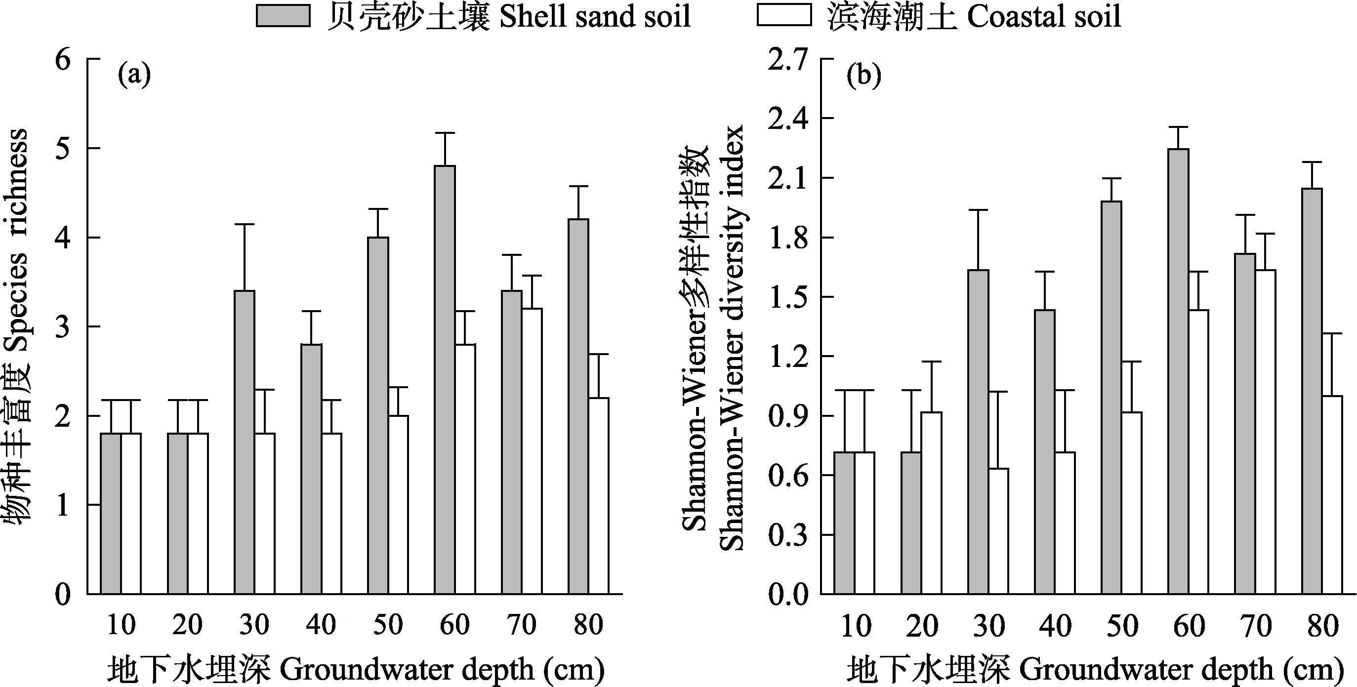
图1 土壤类型和地下水埋深对实验植物群落物种丰富度(a)和Shannon-Wiener多样性指数(b)的影响(平均值 + 标准误)
Fig. 1 Effects of soil type and groundwater depth on the species richness (a) and Shannon-Wiener diversity index (b) of experimental plant communities (mean + SE)
| 变异来源 Variation source | df | 酸枣 Ziziphus jujuba | 蒙古蒿 Artemisia mongolica | 鹅绒藤 Cynanchum chinense | 碱蓬 Suaeda glauca | 盐地碱蓬 Suaeda salsa | 草木犀 Melilotus officinalis | 狗尾草 Setaria viridis |
|---|---|---|---|---|---|---|---|---|
| ST | 1,64 | 85.1*** | 56.8*** | 16.2*** | 0.5ns | 11.8*** | 10.0** | 4.2* |
| GD | 7,64 | 16.6*** | 4.7*** | 2.7* | 0.5ns | 2.3* | 1.4ns | 3.0** |
| ST × GD | 7,64 | 10.9*** | 3.1** | 2.6* | 1.6ns | 0.6ns | 1.4ns | 0.9ns |
表2 土壤类型(ST)和地下水埋深(GD)及其交互作用(ST × GD)对7个物种重要值影响的双因素方差分析结果
Table 2 Two-way ANOVA results of soil type (ST), groundwater depth (GD), and ST × GD on the importance values of seven plant species
| 变异来源 Variation source | df | 酸枣 Ziziphus jujuba | 蒙古蒿 Artemisia mongolica | 鹅绒藤 Cynanchum chinense | 碱蓬 Suaeda glauca | 盐地碱蓬 Suaeda salsa | 草木犀 Melilotus officinalis | 狗尾草 Setaria viridis |
|---|---|---|---|---|---|---|---|---|
| ST | 1,64 | 85.1*** | 56.8*** | 16.2*** | 0.5ns | 11.8*** | 10.0** | 4.2* |
| GD | 7,64 | 16.6*** | 4.7*** | 2.7* | 0.5ns | 2.3* | 1.4ns | 3.0** |
| ST × GD | 7,64 | 10.9*** | 3.1** | 2.6* | 1.6ns | 0.6ns | 1.4ns | 0.9ns |
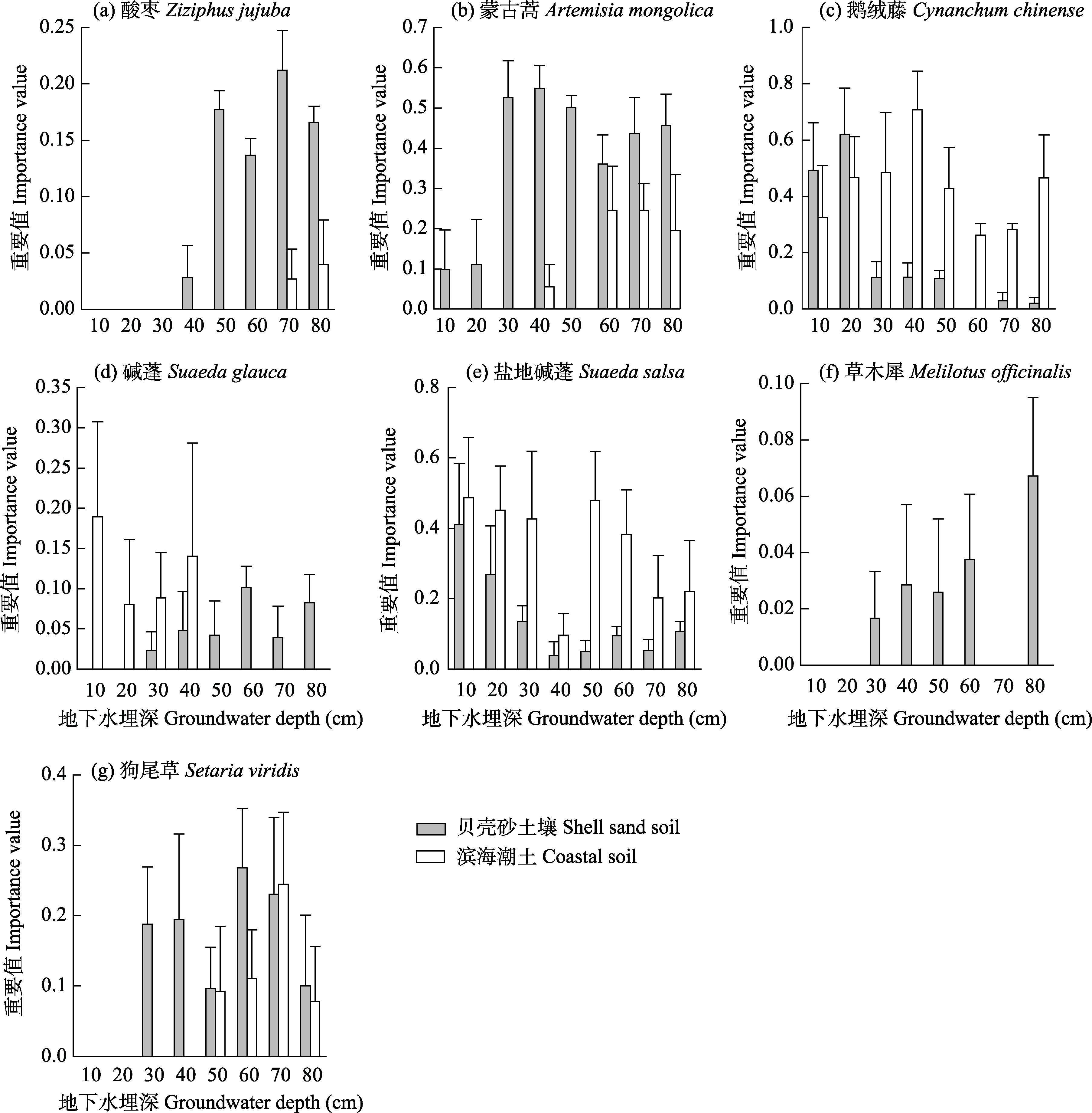
图2 土壤类型和地下水埋深对7个物种重要值的影响(平均值 + 标准误)
Fig. 2 Effects of soil type and groundwater depth on the importance value of seven plant species (mean + SE)
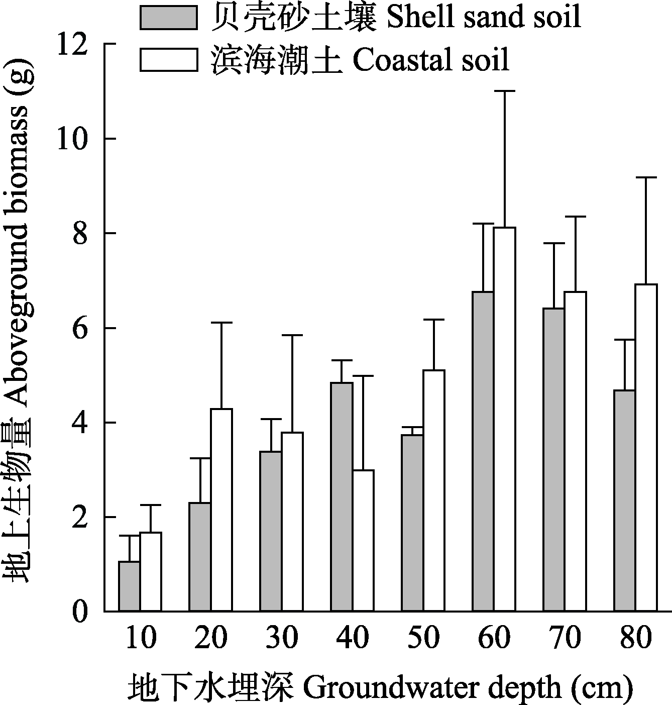
图3 土壤类型和地下水埋深对实验植物群落地上生物量的影响(平均值 + 标准误)
Fig. 3 Effects of soil type and groundwater depth on aboveground biomass of experimental plant communities (mean + SE)
| 变异来源 Variation source | df | 土壤含水量 Soil water content | 土壤含盐量 Soil salt content | 土壤毛管孔隙度 Soil capillary porosity | 土壤容重 Soil bulk density |
|---|---|---|---|---|---|
| ST | 1,64 | 5,675.9*** | 73.2*** | 163.6*** | 6.1* |
| GD | 7,64 | 247.7*** | 1.7ns | 1.0ns | 3.9*** |
| ST × GD | 7,64 | 130.1*** | 4.0*** | 2.5* | 3.5** |
表3 土壤类型(ST)和地下水埋深(GD)及其交互作用(ST × GD)对不同实验植物群落表层基质物理性质影响的双因素方差分析结果
Table 3 Two-way ANOVA results of soil type (ST) and groundwater depth (GD) on the surface physical properties of soil
| 变异来源 Variation source | df | 土壤含水量 Soil water content | 土壤含盐量 Soil salt content | 土壤毛管孔隙度 Soil capillary porosity | 土壤容重 Soil bulk density |
|---|---|---|---|---|---|
| ST | 1,64 | 5,675.9*** | 73.2*** | 163.6*** | 6.1* |
| GD | 7,64 | 247.7*** | 1.7ns | 1.0ns | 3.9*** |
| ST × GD | 7,64 | 130.1*** | 4.0*** | 2.5* | 3.5** |
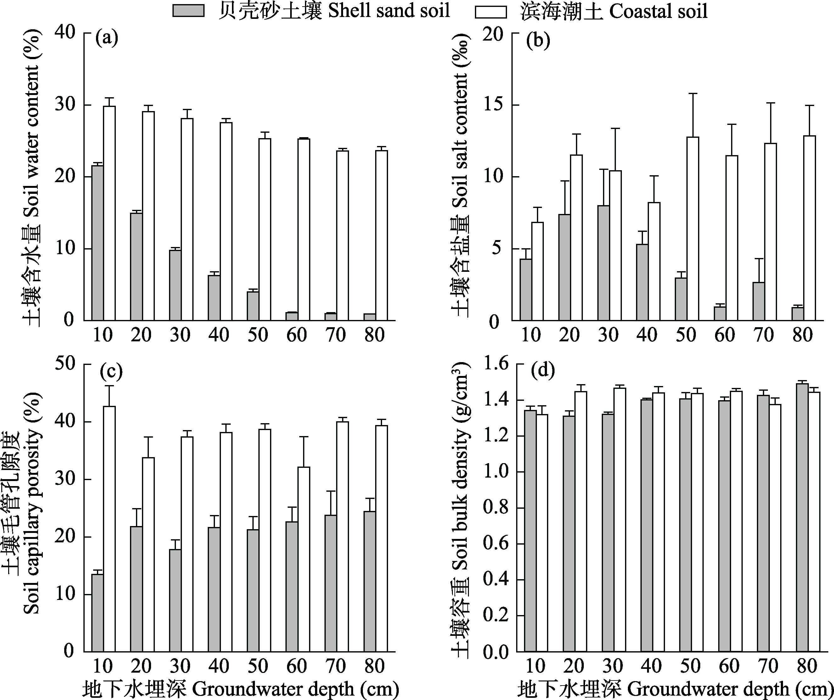
图4 土壤类型和地下水埋深对表层土壤物理性质的影响(平均值 + 标准误)
Fig. 4 Effects of soil type and groundwater depth on the surface soil physical properties (mean + SE)
| 变异来源 Variation source | df | 石砾含量 Gravel content | 粗砂含量 Coarse sand content | 细砂含量 Fine sand content |
|---|---|---|---|---|
| ST | 1,64 | 365.3*** | 49.9*** | 447.5* |
| GD | 7,64 | 0.1ns | 0.5ns | 1.9ns |
| ST × GD | 7,64 | 1.0ns | 1.7ns | 0.4ns |
表4 土壤类型(ST)和地下水埋深(GD)及其交互作用(ST × GD)对表层土壤颗粒组成影响的双因素方差分析结果
Table 4 Two-way ANOVA results of soil type (ST) and groundwater depth (GD) on the surface soil particle composition
| 变异来源 Variation source | df | 石砾含量 Gravel content | 粗砂含量 Coarse sand content | 细砂含量 Fine sand content |
|---|---|---|---|---|
| ST | 1,64 | 365.3*** | 49.9*** | 447.5* |
| GD | 7,64 | 0.1ns | 0.5ns | 1.9ns |
| ST × GD | 7,64 | 1.0ns | 1.7ns | 0.4ns |
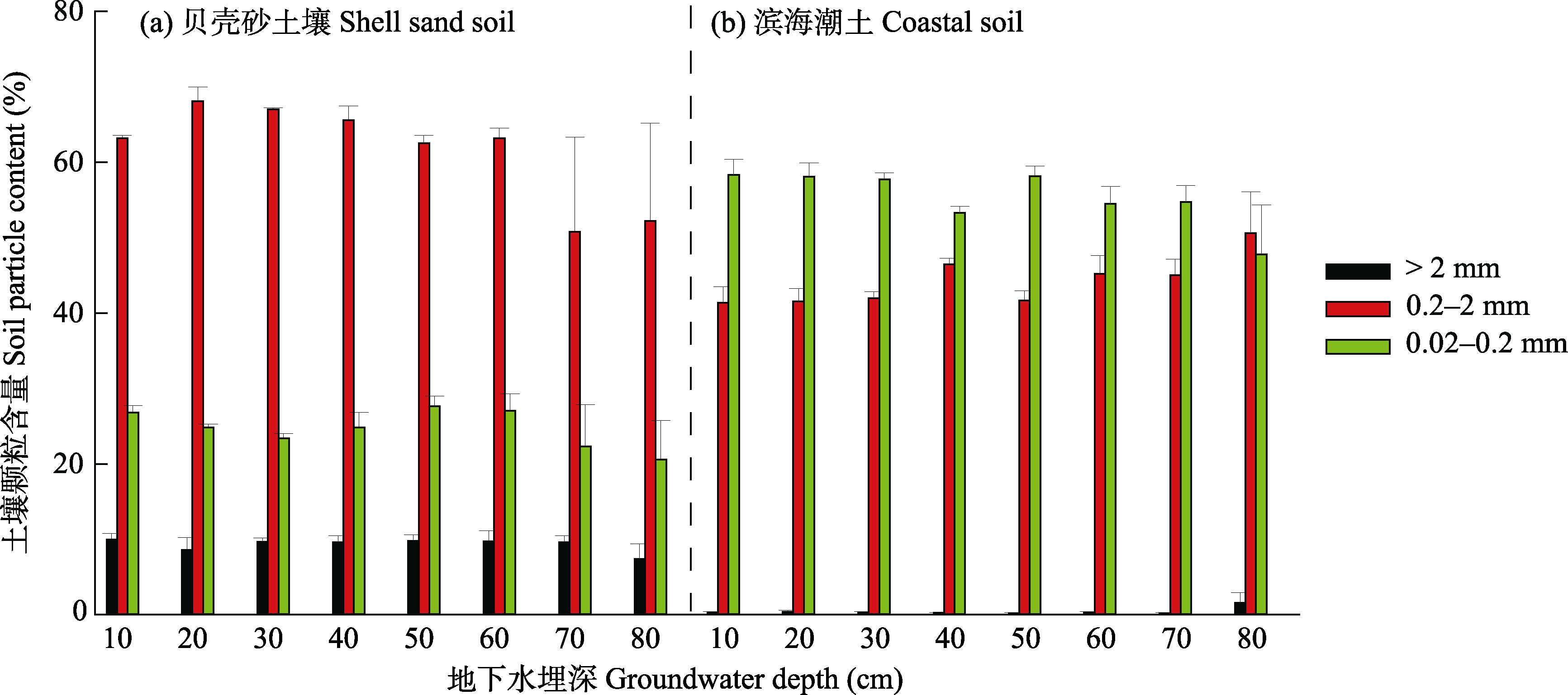
图5 地下水埋深对贝壳砂土壤(a)和滨海潮土(b)表层土壤颗粒组成的影响(平均值 + 标准误)
Fig. 5 Effects of groundwater depth on the surface soil particle composition of shell sand soil (a) and coastal soil (b) (mean + SE)
| [1] | An LS, Zhou BH, Zhao QS, Wang L (2017) Spatial distribution of vegetation and environmental interpretation in the Yellow River Delta. Acta Ecologica Sinica, 37, 6809-6817. (in Chinese with English abstract) |
| [安乐生, 周葆华, 赵全升, 王磊 (2017) 黄河三角洲植被空间分布特征及其环境解释. 生态学报, 37, 6809-6817.] | |
| [2] |
Bai YF, Xu HL, Zhang P, Zhang GP, Ling HB (2017) Relation of desert vegetation species diversity and aboveground biomass to groundwater depth in the lower reaches of Tarim River. Journal of Desert Research, 37, 724-732. (in Chinese with English abstract)
DOI |
|
[白玉锋, 徐海量, 张沛, 张广朋, 凌红波 (2017) 塔里木河下游荒漠植物多样性、地上生物量与地下水埋深的关系. 中国沙漠, 37, 724-732.]
DOI |
|
| [3] |
Bertness MD (1991) Zonation of Spartina patens and Spartina alterniflora in a new England salt marsh. Ecology, 72, 138-148.
DOI URL |
| [4] |
Chen P, Sun J, Ma L, Chen YP, Xia JB (2022) Effects of shell sand content on soil physical properties and salt ions under simulated rainfall leaching. Geoderma, 406, 115520.
DOI URL |
| [5] |
Chen YP, Xia JB, Zhao XM, Zhuge YP (2019) Soil moisture ecological characteristics of typical shrub and grass vegetation on Shell Island in the Yellow River Delta, China. Geoderma, 348, 45-53.
DOI URL |
| [6] | Chen GG (2020) Effects of Changes in Groundwater Depth and Soil Physicochemical Properties on Plant Communities in the Lower Shule River. PhD dissertation, Lanzhou University, Lanzhou. (in Chinese with English abstract) |
| [陈冠光 (2020) 疏勒河下游地下水埋深与土壤理化性质变化对植物群落的影响. 博士学位论文, 兰州大学, 兰州.] | |
| [7] |
Cui BS, He Q, An Y (2011a) Community structure and abiotic determinants of salt marsh plant zonation vary across topographic gradients. Estuaries and Coasts, 34, 459-469.
DOI URL |
| [8] |
Cui BS, He Q, Zhang KJ, Chen X (2011b) Determinants of annual-perennial plant zonation across a salt-fresh marsh interface: A multistage assessment. Oecologia, 166, 1067-1075.
DOI URL |
| [9] | Ding HA (2013) Yellow River Delta National Nature Reserve of Shandong Province. Wetland Science and Management, 9(3), 2-3. (in Chinese) |
| [丁洪安 (2013) 山东黄河三角洲国家级自然保护区. 湿地科学与管理, 9(3), 2-3.] | |
| [10] | Dong LS, Song AY, Sun JK, Zhao XM, Yang HJ, Qu FZ, Li H, Fu ZY (2016) Spatial variability of soil salinity in the Shell Ridge Island of the Yellow River Delta. Journal of Soi1 and Water Conservation, 30(6), 289-295. (in Chinese with English abstract) |
| [董林水, 宋爱云, 孙景宽, 赵西梅, 杨红军, 屈凡柱, 李华, 付战勇 (2016) 黄河三角洲贝壳堤土壤盐分空间分异特征. 水土保持学报, 30(6), 289-295.] | |
| [11] | Fang Y, Liang Y, Liu YL, Du XH (2009) Quantitative analysis and ordination of vegetation in Yellow River Delta. Scientia Silvae Sinicae, 45(10), 152-154. (in Chinese with English abstract) |
| [房用, 梁玉, 刘月良, 杜相海 (2009) 黄河三角洲湿地植被群落数量分类与排序. 林业科学, 45(10), 152-154.] | |
| [12] | Fu ZY, Sun JK, Li CR, Liu JT, Yang HJ, Qu FZ, Dong LS, Li T (2017) Potential water source of soil water in the chenier of Yellow River Delta. Wetland Science, 15, 829-833. (in Chinese with English abstract) |
| [付战勇, 孙景宽, 李传荣, 刘京涛, 杨红军, 屈凡柱, 董林水, 李田 (2017) 黄河三角洲贝壳堤土壤水潜在水源研究. 湿地科学, 15, 829-833.] | |
| [13] | Fu ZY, Wang P, Sun JK, Lu ZH, Yang HJ, Liu JT, Xia JB, Li T (2020) Composition, seasonal variation, and salinization characteristics of soil salinity in the Chenier Island of the Yellow River Delta. Global Ecology and Conservation, 24, e01318. |
| [14] |
Gagnon K, Rinde E, Bengil EGT, Carugati L, Christianen MJA, Danovaro R, Gambi C, Govers LL, Kipson S, Meysick L, Pajusalu L, Tüney Kızılkaya İ, van de Koppel J, van der Heide T, van Katwijk MM, Boström C (2020) Facilitating foundation species: The potential for plant-bivalve interactions to improve habitat restoration success. Journal of Applied Ecology, 57, 1161-1179.
DOI URL |
| [15] |
Guo H, Pennings ST (2012) Post-mortem ecosystem engineering by oysters creates habitat for a rare marsh plant. Oecologia, 170, 789-798.
DOI PMID |
| [16] | He Q (2013) Bottom-up, Interspecific and Top-down Determinants of Plant Communities in Salt Marshes in the Yellow River Estuary. PhD dissertation, Shanghai Jiao Tong University, Shanghai. (in Chinese with English abstract) |
| [贺强 (2013) 黄河口盐沼植物群落的上行、种间和下行控制因子. 博士学位论文, 上海交通大学, 上海.] | |
| [17] | He Q, An Y, Cui BS (2010) Coastal salt marshes and distribution and diversity of salt marsh plant communities. Ecology and Environmental Sciences, 19, 657-664. (in Chinese with English abstract) |
|
[贺强, 安渊, 崔宝山 (2010) 滨海盐沼及其植物群落的分布与多样性. 生态环境学报, 19, 657-664.]
DOI |
|
| [18] |
He Q, Bertness MD (2014) Extreme stresses, niches, and positive species interactions along stress gradients. Ecology, 95, 1437-1443.
DOI PMID |
| [19] | He Q, Cui BS, Cai YZ, Deng JF, Sun T, Yang ZF (2009) What confines an annual plant to two separate zones along coastal topographic gradients? Hydrobiologia, 630, 327-340. |
| [20] |
He Q, Bertness MD, Altieri AH (2013) Global shifts towards positive species interactions with increasing environmental stress. Ecology Letters, 16, 695-706.
DOI PMID |
| [21] | Huang SG (1993) Erosion and accumulation in the adjacent area of the Taoerhe Bay—With emphasis on erosion-accumulation of the Huanghe River Delta after its shifted course. Oceanologia et Limnologia Sinica, 24, 197-204. (in Chinese with English abstract) |
| [黄世光 (1993) 套尔河湾海域泥沙冲淤特征——兼论黄河改道后三角洲的冲淤演化. 海洋与湖沼, 24, 197-204 ] | |
| [22] | Keddy PA (2000) Wetland Ecology:Principles and Conservation. Cambridge University Press, Cambridge. |
| [23] |
Li XQ, Xia JB, Zhao XM, Chen YP (2019) Effects of planting Tamarix chinensis on shallow soil water and salt content under different groundwater depths in the Yellow River Delta. Geoderma, 335, 104-111.
DOI URL |
| [24] | Ma YL, Wang D, Liu JM, Wen XH, Gao M, Shao HB (2013) Relationships between typical vegetations, soil salinity, and groundwater depth in the Yellow River Delta of China. Chinese Journal of Applied Ecology, 24, 2423-2430. (in Chinese with English abstract) |
| [马玉蕾, 王德, 刘俊民, 温小虎, 高猛, 邵宏波 (2013) 黄河三角洲典型植被与地下水埋深和土壤盐分的关系. 应用生态学报, 24, 2423-2430.] | |
| [25] |
Moy LD, Levin LA (1991) Are Spartina marshes a replaceable resource? A functional approach to evaluation of marsh creation efforts. Estuaries, 14, 1-16.
DOI URL |
| [26] | Pan HJ, Tian JY, Gu FT (2001) Seashell islands near the Yellow River Delta and protection of their plant diversity. Marine Environmental Science, 20(3), 54-59. (in Chinese with English abstract) |
| [潘怀剑, 田家怡, 谷奉天 (2001) 黄河三角洲贝壳海岛与植物多样性保护. 海洋环境科学, 20(3), 54-59.] | |
| [27] | Ren J, Chen J, Xu C, van de Koppel J, Thomsen MS, Qiu S, Cheng F, Song W, Liu Q, Xu C, Bai J, Zhang Y, Cui B, Bertness MD, Silliman BR, Li B, He Q (2021) An invasive species erodes the performance of coastal wetland protected areas. Science Advances, 7, eabi8943. |
| [28] | Ren RR, Xia JB, Zhang SY, Chen YP, Liu MX (2020) Fractal characteristics of soil particles in shrub-grass communities in the Chenier of the Yellow River Delta. Science of Soil and Water Conservation, 18(3), 48-58. (in Chinese with English abstract) |
| [任冉冉, 夏江宝, 张淑勇, 陈印平, 刘明新 (2020) 黄河三角洲贝壳堤灌草群落的土壤颗粒分形特征. 中国水土保持科学, 18(3), 48-58.] | |
| [29] | Silliman BR (2014) Salt marshes. Current Biology, 24, R348-R350. |
| [30] | Silliman BR, van de Koppel J, McCoy MW, Diller J, Kasozi GN, Earl K, Adams PN, Zimmerman AR (2012) Degradation and resilience in Louisiana salt marshes after the BP-Deepwater horizon oil spill. Proceedings of the National Academy of Sciences, USA, 109, 11234-11239. |
| [31] |
Sun J, Xia JB, Shao PS, Ma JZ, Gao FL, Lang Y, Xing XS, Dong MM, Li CR (2022) Response of the fine root morphological and chemical traits of Tamarix chinensis to water and salt changes in coastal wetlands of the Yellow River Delta. Frontiers in Plant Science, 13, 952830.
DOI URL |
| [32] | Tian JY, Xie WJ, Sun JK (2009) Current status of vulnerable ecosystem of Shell Islands and protection measures in Yellow River Delta. Environmental Science and Management, 34(8), 138-143. (in Chinese with English abstract) |
| [田家怡, 谢文军, 孙景宽 (2009) 黄河三角洲贝壳堤岛脆弱生态系统破会现状及保护对策. 环境科学与管理, 34(8), 138-143.] | |
| [33] | Wang RQ, Zhang YH, Sun SX, Zheng PM (2021) Review and prospect of vegetation research in the Yellow River Delta. Journal of Shandong University (Natural Science), 56(10), 135-148. (in Chinese with English abstract) |
| [王仁卿, 张煜涵, 孙淑霞, 郑培明 (2021) 黄河三角洲植被研究回顾与展望. 山东大学学报(理学版), 56(10), 135-148.] | |
| [34] | Wang XH, Li YZ, Meng H, Dong HF, Guo Y, Tong SZ (2015) Distribution pattern of plant community in new-born coastal wetland in the Yellow River Delta. Scientia Geographica Sinica, 35, 1021-1026. (in Chinese with English abstract) |
|
[王雪宏, 栗云召, 孟焕, 董洪芳, 郭岳, 佟守正 (2015) 黄河三角洲新生湿地植物群落分布格局. 地理科学, 35, 1021-1026.]
DOI |
|
| [35] | Wu DQ (2010) Spatial Pattern, Dynamic Monitoring and Simulation of the Vegetation in the Yellow River Delta. PhD dissertation, Shandong University, Ji’nan. (in Chinese with English abstract) |
| [吴大千 (2010) 黄河三角洲植被的空间格局、动态监测与模拟. 博士学位论文, 山东大学, 济南.] | |
| [36] |
Xia JB, Ren RR, Chen YP, Sun J, Zhao XM, Zhang SY (2020) Multifractal characteristics of soil particle distribution under different vegetation types in the Yellow River Delta Chenier of China. Geoderma, 368, 114311.
DOI URL |
| [37] |
Xia JB, Zhao ZG, Fang Y (2017) Soil hydro-physical characteristics and water retention function of typical shrubbery stands in the Yellow River Delta of China. CATENA, 156, 315-324.
DOI URL |
| [38] |
Xia JB, Zhang SY, Zhao XM, Liu JH, Chen YP (2016) Effects of different groundwater depths on the distribution characteristics of soil-Tamarix water contents and salinity under saline mineralization conditions. CATENA, 142, 166-176.
DOI URL |
| [39] | Xiao L, Yang SC, Hou R, Liu CA, Lu WZ, Chen PF (2018) Ecological niche characteristics of vascular plant species in the Natural Chenier Island Reserve of Wudi, Shandong Province. Journal of Xiamen University (Natural Science), 57(1), 79-84. (in Chinese with English abstract) |
| [肖兰, 杨盛昌, 侯蕊, 刘长安, 卢伟志, 陈鹏飞 (2018) 山东无棣贝壳堤岛保护区维管束植物的生态位特征. 厦门大学学报(自然科学版), 57(1), 79-84.] | |
| [40] |
Xie WJ, Zhao YY, Zhang ZD, Liu Q, Xia JB, Sun JK, Tian JY, Sun TQ (2012) Shell sand properties and vegetative distribution on shell ridges of the southwestern coast of Bohai Bay. Environmental Earth Sciences, 67, 1357-1362.
DOI URL |
| [41] | Xue CT (2010) The present situation, management and approaches of the Shelly Ridges along the west coast of the Bohai Sea in the natural reserves, Hebei and Shandong provinces. Marine Geology Letters, 26(1), 41-44. (in Chinese with English abstract) |
| [薛春汀 (2010) 渤海西岸自然保护区内贝壳堤现状和应对措施. 海洋地质动态, 26(1), 41-44.] | |
| [42] | Yao RJ, Yang JS (2007) Evaluation on spatial distribution of groundwater depth and soil salinity by indicator Kriging in a typical area of Yellow River Delta. Journal of Agro-Environment Science, 26, 2118-2124. (in Chinese with English abstract) |
| [姚荣江, 杨劲松 (2007) 黄河三角洲典型地区地下水位与土壤盐分空间分布的指示克立格评价. 农业环境科学学报, 26, 2118-2124.] | |
| [43] | Yu M, Li YZ, Qu FZ, Zhou D, Zhan C, Wang XH (2020) Spatio-temporal changes and trend prediction of degraded coastal wetlands in the Yellow River Delta. Journal of Agricultural Resources and Environment, 37, 484-492. (in Chinese with English abstract) |
| [于淼, 栗云召, 屈凡柱, 周迪, 战超, 王雪宏 (2020) 黄河三角洲滨海湿地退化过程的时空变化及预测分析. 农业资源与环境学报, 37, 484-492.] | |
| [44] | Zhang J, Zhao ZH, Wang D, Ma HY, Guo L (2013) The quantitative relationship between vegetations and groundwater depth in shallow groundwater area of Ordos Plateau. Journal of Arid Land Resources and Environment, 27(4), 141-145. (in Chinese with English abstract) |
| [张俊, 赵振宏, 王冬, 马洪云, 郭莉 (2013) 鄂尔多斯高原地下水浅埋区植被与地下水埋深关系. 干旱区资源与环境, 27(4), 141-145.] | |
| [45] |
Zhang K, Xia JB, Su L, Gao FL, Cui Q, Xing XS, Dong MM, Li CR (2023) Effects of microtopographic patterns on plant growth and soil improvement in coastal wetlands of the Yellow River Delta. Frontiers in Plant Science, 14, 1162013.
DOI URL |
| [46] | Zhao M, Chang CY, Wang ZR, Zhao GX (2023) Influential factors and prediction model of soil salinity at different depths in the coastal area of the Yellow River Delta. Heilongjiang Agricultural Sciences, (2), 23-24. (in Chinese with English abstract) |
| [赵铭, 常春艳, 王卓然, 赵庚星 (2023) 黄三角濒海区不同土层土壤盐分影响因素及预测模型. 黑龙江农业科学, (2), 23-34.] | |
| [47] | Zhao XS, Lü JZ, Sun T (2009) Relations between the distribution of vegetation and environment in the Yellow River Delta and SPPA for Chinese tamarisk spatial distribution. Journal of Beijing Forestry University, 31(3), 29-36. (in Chinese with English abstract) |
| [赵欣胜, 吕卷章, 孙涛 (2009) 黄河三角洲植被分布环境解释及柽柳空间分布点格局分析. 北京林业大学学报, 31(3), 29-36.] | |
| [48] |
Zhao YY, Hu XM, Liu JT, Lu ZH, Xia JB, Tian JY, Ma JS (2015) Vegetation pattern in Shell Ridge Island in China’s Yellow River Delta. Frontiers of Earth Science, 9, 567-577.
DOI |
| [49] | Zhao YY, Tian JY, Sun JK, Hu XM (2010) The relationship between biological diversity of Shell Bar in the North of Binzhou and soil physical and chemical properties. Research of Soil and Water Conservation, 17, 136-140. (in Chinese with English abstract) |
| [赵艳云, 田家怡, 孙景宽, 胡相明 (2010) 滨州北部贝沙堤生物多样性现状及影响因素的研究. 水土保持研究, 17, 136-140.] |
| [1] | 朱芸, 王凯红, 李洪磊, 徐向龙, 雷宇, 陈浩, 陈卫华, 蔡新杰, 丁长青. 朱鹮对滨海食物的适应性研究——恢复东部沿海朱鹮种群的初步探索[J]. 生物多样性, 2026, 34(5): 26051-. |
| [2] | 黄薇, 刘一凡, 方涛, 赵微, 吴婷, 靳瑜, 王荣, 罗芳丽, 郭允倩, 朱耀军. 刈割后互花米草残体与覆膜对滨海湿地土壤理化性质及细菌群落结构的影响[J]. 生物多样性, 2026, 34(5): 25468-. |
| [3] | 石亚飞, 牛富荣, 黄晓敏, 洪星, 龚相文, 王艳莉, 林栋, 柳小妮. 可解释机器学习及其生态学应用[J]. 生物多样性, 2026, 34(1): 25210-. |
| [4] | 李帅, 刘卫华, 许驭丹, 田晓波, 宋厚娟, 岳晓婷, 武玲玲, 张青, 上官铁梁. 山西省野生维管植物编目和分布数据集[J]. 生物多样性, 2025, 33(7): 24317-. |
| [5] | 林秦文, 张娜, 王强. 中国盐生植物编目和分布数据集[J]. 生物多样性, 2025, 33(7): 25030-. |
| [6] | 杨泉峰, 唐艳杰, 肖海军, 王颖, 张蓉, 欧阳芳, 魏淑花. 宁夏不同草原类型植物多样性-蝗虫-步甲的级联效应及对初级生产力的影响[J]. 生物多样性, 2025, 33(6): 25021-. |
| [7] | 宋威, 程才, 王嘉伟, 吴纪华. 土壤微生物对植物多样性-生态系统功能关系的调控作用[J]. 生物多样性, 2025, 33(4): 24579-. |
| [8] | 张浩斌, 肖路, 刘艳杰. 夜间灯光对外来入侵植物和本地植物群落多样性和生长的影响[J]. 生物多样性, 2025, 33(4): 24553-. |
| [9] | 宋远昊, 龚吕, 李贲, 胡阳, 李秀珍. 辽河口不同退塘还湿方式对大型底栖动物的影响[J]. 生物多样性, 2025, 33(2): 24316-. |
| [10] | 卢炜煜, 陈旭, 张日谦, 张云海, 李昭. 氮和牛粪输入对典型草原植物种-面积关系的影响[J]. 生物多样性, 2025, 33(12): 25251-. |
| [11] | 连佳丽, 陈婧, 杨雪琴, 赵莹, 罗叙, 韩翠, 赵雅欣, 李建平. 荒漠草原植物多样性和微生物多样性对降水变化的响应[J]. 生物多样性, 2024, 32(6): 24044-. |
| [12] | 万凤鸣, 万华伟, 张志如, 高吉喜, 孙晨曦, 王永财. 草地植物多样性无人机调查的应用潜力[J]. 生物多样性, 2024, 32(3): 23381-. |
| [13] | 蒋陈焜, 郁文彬, 饶广远, 黎怀成, Julien B. Bachelier, Hartmut H. Hilger, Theodor C. H. Cole. 植物系统发生海报——以演化视角介绍植物多样性的科教资料项目[J]. 生物多样性, 2024, 32(11): 24210-. |
| [14] | 韩赟, 迟晓峰, 余静雅, 丁旭洁, 陈世龙, 张发起. 青海野生维管植物名录[J]. 生物多样性, 2023, 31(9): 23280-. |
| [15] | 陈又生, 宋柱秋, 卫然, 罗艳, 陈文俐, 杨福生, 高连明, 徐源, 张卓欣, 付鹏程, 向春雷, 王焕冲, 郝加琛, 孟世勇, 吴磊, 李波, 于胜祥, 张树仁, 何理, 郭信强, 王文广, 童毅华, 高乞, 费文群, 曾佑派, 白琳, 金梓超, 钟星杰, 张步云, 杜思怡. 西藏维管植物多样性编目和分布数据集[J]. 生物多样性, 2023, 31(9): 23188-. |
| 阅读次数 | ||||||
|
全文 |
|
|||||
|
摘要 |
|
|||||
备案号:京ICP备16067583号-7
Copyright © 2026 版权所有 《生物多样性》编辑部
地址: 北京香山南辛村20号, 邮编:100093
电话: 010-62836137, 62836665 E-mail: biodiversity@ibcas.ac.cn
![]()