
生物多样性 ›› 2017, Vol. 25 ›› Issue (1): 53-61. DOI: 10.17520/biods.2016259 cstr: 32101.14.biods.2016259
所属专题: 青藏高原生物多样性与生态安全
冯晨光1,2,3, 童超1,2,3, 张仁意1,2, 李国刚1,2, 王贺崐元1,2,3, 汤永涛1,2,3, 张存芳1,2,*( ), 赵凯1,2,*()
收稿日期:2016-09-12
接受日期:2016-12-30
出版日期:2017-01-20
发布日期:2017-02-08
通讯作者:
张存芳,赵凯
基金资助:
Chenguang Feng1,2,3, Chao Tong1,2,3, Renyi Zhang1,2, Guogang Li1,2, Kunyuan Wanghe1,2,3, Yongtao Tang1,2,3, Cunfang Zhang1,2,*(), Kai Zhao1,2,*()
Received:2016-09-12
Accepted:2016-12-30
Online:2017-01-20
Published:2017-02-08
Contact:
Zhang Cunfang,Zhao Kai
摘要:
为了了解青藏高原东北部边缘地区高原鳅属(Triplophysa)鱼类的多样性和分布格局, 本文基于2012-2015年的野外调查数据, 对该地区高原鳅属鱼类的分布情况进行了调查。结果发现: 与历史记录相比, 部分物种的分布区已经萎缩或破碎化。物种在整个区域的分布很不均匀, 其中洮河、大通河和黑河的中上游是高原鳅分布较集中的地区; 同时这3条河也有着较高的多样性水平。海拔梯度上, 物种丰富度呈现随海拔上升先增后减的单峰分布模式, 在2,200-2,400 m海拔区间最高; 且峰值点出现在两个物种丰富的群落的过渡区, 很好地印证了Lomolino对物种密度海拔分布的预测。多样性指数的海拔回归分析获得与物种丰富度的海拔分布相一致的结果。结合已有报道, 我们认为这种中间海拔最大的单峰分布模式可能是青藏高原及其周边地区物种多样性分布的普遍规律。因而, 中海拔地区需要优先保护。
冯晨光, 童超, 张仁意, 李国刚, 王贺崐元, 汤永涛, 张存芳, 赵凯 (2017) 青藏高原东北部边缘高原鳅属鱼类的 多样性与分布格局. 生物多样性, 25, 53-61. DOI: 10.17520/biods.2016259.
Chenguang Feng, Chao Tong, Renyi Zhang, Guogang Li, Kunyuan Wanghe, Yongtao Tang, Cunfang Zhang, Kai Zhao (2017) Biodiversity and distribution patterns of Triplophysa species in the northeastern margin of the Tibetan Plateau. Biodiversity Science, 25, 53-61. DOI: 10.17520/biods.2016259.
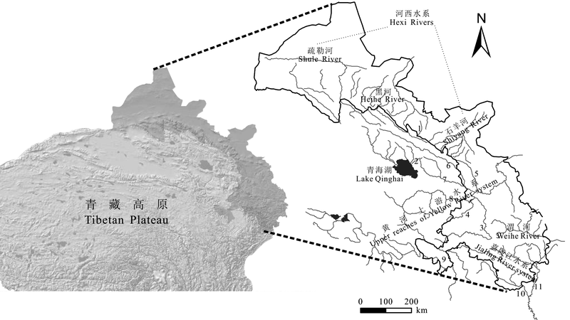
图1 调查区域水系图示。右图灰色线中, 1: 大马营河; 2: 甘子河; 3: 洮河; 4: 大夏河; 5: 庄浪河; 6: 大通河; 7: 湟水河; 8: 贵德; 9: 玛曲; 10: 白龙江; 11: 嘉陵江上游。
Fig. 1 Drainage systems of investigation area. Gray lines in right part: 1, Damaying River; 2, Ganzi River; 3, Taohe River; 4, Daxia River; 5, Zhuanglang River; 6, Datong River; 7, Huangshui River; 8, Guide; 9, Maqu; 10, Bailong River; 11, Upper reaches of Jialing River.
| 水系 Basin | 水系单元 Basin unit | 物种丰富度 Species richness | Shannon-Wiener指数 Shannon-Wiener index | Pielou指数 Pielou index | Simpson指数 Simpson index |
|---|---|---|---|---|---|
| 河西 Hexi rivers | 疏勒河干流 Shule River | 4 | 0.690 ± 0.114 | 0.727 ± 0.074 | 0.553 ± 0.047 |
| 疏勒河附属水体 Tributaries of Shule River | 2 | 0.560 ± 0.217 | 0.810 ± 0.312 | 0.556 ± 0.250 | |
| 黑河干流 Heihe River | 6 | 1.136 ± 0.213 | 0.842 ± 0.078 | 0.350 ± 0.064 | |
| 黑河附属水体—大马营河 Damaying-tributary of Heihe River | 4 | 1.100 | 0.790 | 0.346 | |
| 黑河附属水体—其他 Other tributaries of Heihe River | 2 | 0.320 ± 0.157 | 0.463 ± 0.229 | 0.806 ± 0.117 | |
| 石羊河干流 Shiyang River | 4 | 1.035 ± 0.093 | 0.893 ± 0.121 | 0.364 ± 0.035 | |
| 石羊河附属水体 Tributaries of Shiyang River | 2 | 0.640 ± 0.044 | 0.923 ± 0.064 | 0.545 ± 0.040 | |
| 小计 Subtotal | 7 | ||||
| 青海湖 Lake Qinghai | 甘子河 Ganzi River | 2 | 0.620 ± 0.028 | 0.890 ± 0.042 | 0.539 ± 0.054 |
| 入湖河流 Tributaries of Qinghai Lake | 2 | 0.673 ± 0.029 | 0.973 ± 0.046 | 0.418 ± 0.075 | |
| 小计 Subtotal | 4 | ||||
| 黄河上游 Upper reaches of Yellow River | 洮河 Taohe River | 8 | 1.198 ± 0.246 | 0.848 ± 0.122 | 0.337 ± 0.072 |
| 大夏河 Daxia River | 4 | 0.573 ± 0.107 | 0.633 ± 0.261 | 0.589 ± 0.229 | |
| 庄浪河 Zhuanglang River | 4 | 0.570 | 0.410 | 0.723 | |
| 大通河 Datong River | 6 | 1.390 ± 0.014 | 0.820 ± 0.057 | 0.293 ± 0.019 | |
| 湟水河 Huangshui River | 7 | 1.060 ± 0.159 | 0.753 ± 0.130 | 0.368 ± 0.103 | |
| 贵德至玛曲段 Guide-Maqu section | 4 | 0.777 ± 0.168 | 0.950 ± 0.053 | 0.417 ± 0.086 | |
| 玛曲段 Maqu section | 6 | 0.645 ± 0.134 | 0.515 ± 0.021 | 0.674 ± 0.049 | |
| 玛曲至玛多段 Maqu-Maduo section | 3 | 0.530 ± 0.382 | 0.545 ± 0.247 | 0.667 ± 0.269 | |
| 小计 Subtotal | 12 | ||||
| 渭河 Weihe River | 渭河上游 Upper reaches of Weihe River | 4 | 1.010 ± 0.113 | 0.790 ± 0.098 | 0.419 ± 0.045 |
| 嘉陵江 Jialing River | 白龙江 Bailong River | 4 | 0.845 ± 0.247 | 0.950 ± 0.028 | 0.446 ± 0.104 |
| 嘉陵江上游 Upper reaches of Jialing River | 3 | 0.990 | 0.900 | 0.392 | |
| 小计 Subtotal | 5 |
表1 青藏高原东北部边缘地区高原鳅属鱼类的多样性(平均值 ± 标准差)
Table 1 Fish diversity of Triplophysa species in northeastern margin of Tibetan Plateau (mean ± SD)
| 水系 Basin | 水系单元 Basin unit | 物种丰富度 Species richness | Shannon-Wiener指数 Shannon-Wiener index | Pielou指数 Pielou index | Simpson指数 Simpson index |
|---|---|---|---|---|---|
| 河西 Hexi rivers | 疏勒河干流 Shule River | 4 | 0.690 ± 0.114 | 0.727 ± 0.074 | 0.553 ± 0.047 |
| 疏勒河附属水体 Tributaries of Shule River | 2 | 0.560 ± 0.217 | 0.810 ± 0.312 | 0.556 ± 0.250 | |
| 黑河干流 Heihe River | 6 | 1.136 ± 0.213 | 0.842 ± 0.078 | 0.350 ± 0.064 | |
| 黑河附属水体—大马营河 Damaying-tributary of Heihe River | 4 | 1.100 | 0.790 | 0.346 | |
| 黑河附属水体—其他 Other tributaries of Heihe River | 2 | 0.320 ± 0.157 | 0.463 ± 0.229 | 0.806 ± 0.117 | |
| 石羊河干流 Shiyang River | 4 | 1.035 ± 0.093 | 0.893 ± 0.121 | 0.364 ± 0.035 | |
| 石羊河附属水体 Tributaries of Shiyang River | 2 | 0.640 ± 0.044 | 0.923 ± 0.064 | 0.545 ± 0.040 | |
| 小计 Subtotal | 7 | ||||
| 青海湖 Lake Qinghai | 甘子河 Ganzi River | 2 | 0.620 ± 0.028 | 0.890 ± 0.042 | 0.539 ± 0.054 |
| 入湖河流 Tributaries of Qinghai Lake | 2 | 0.673 ± 0.029 | 0.973 ± 0.046 | 0.418 ± 0.075 | |
| 小计 Subtotal | 4 | ||||
| 黄河上游 Upper reaches of Yellow River | 洮河 Taohe River | 8 | 1.198 ± 0.246 | 0.848 ± 0.122 | 0.337 ± 0.072 |
| 大夏河 Daxia River | 4 | 0.573 ± 0.107 | 0.633 ± 0.261 | 0.589 ± 0.229 | |
| 庄浪河 Zhuanglang River | 4 | 0.570 | 0.410 | 0.723 | |
| 大通河 Datong River | 6 | 1.390 ± 0.014 | 0.820 ± 0.057 | 0.293 ± 0.019 | |
| 湟水河 Huangshui River | 7 | 1.060 ± 0.159 | 0.753 ± 0.130 | 0.368 ± 0.103 | |
| 贵德至玛曲段 Guide-Maqu section | 4 | 0.777 ± 0.168 | 0.950 ± 0.053 | 0.417 ± 0.086 | |
| 玛曲段 Maqu section | 6 | 0.645 ± 0.134 | 0.515 ± 0.021 | 0.674 ± 0.049 | |
| 玛曲至玛多段 Maqu-Maduo section | 3 | 0.530 ± 0.382 | 0.545 ± 0.247 | 0.667 ± 0.269 | |
| 小计 Subtotal | 12 | ||||
| 渭河 Weihe River | 渭河上游 Upper reaches of Weihe River | 4 | 1.010 ± 0.113 | 0.790 ± 0.098 | 0.419 ± 0.045 |
| 嘉陵江 Jialing River | 白龙江 Bailong River | 4 | 0.845 ± 0.247 | 0.950 ± 0.028 | 0.446 ± 0.104 |
| 嘉陵江上游 Upper reaches of Jialing River | 3 | 0.990 | 0.900 | 0.392 | |
| 小计 Subtotal | 5 |
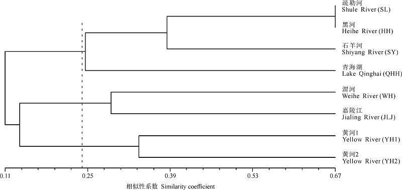
图2 研究区域各水系单元基于高原鳅属物种组成的UPGMA聚类分析。YH1是黄河上游水系贵德以下段, YH2是黄河上游水系贵德以上段。
Fig. 2 UPGMA cluster of basin units in study area based on component of Triplophysa species. YH1 and YH2 are the sections above and below of Guide in upper reaches of Yellow River.
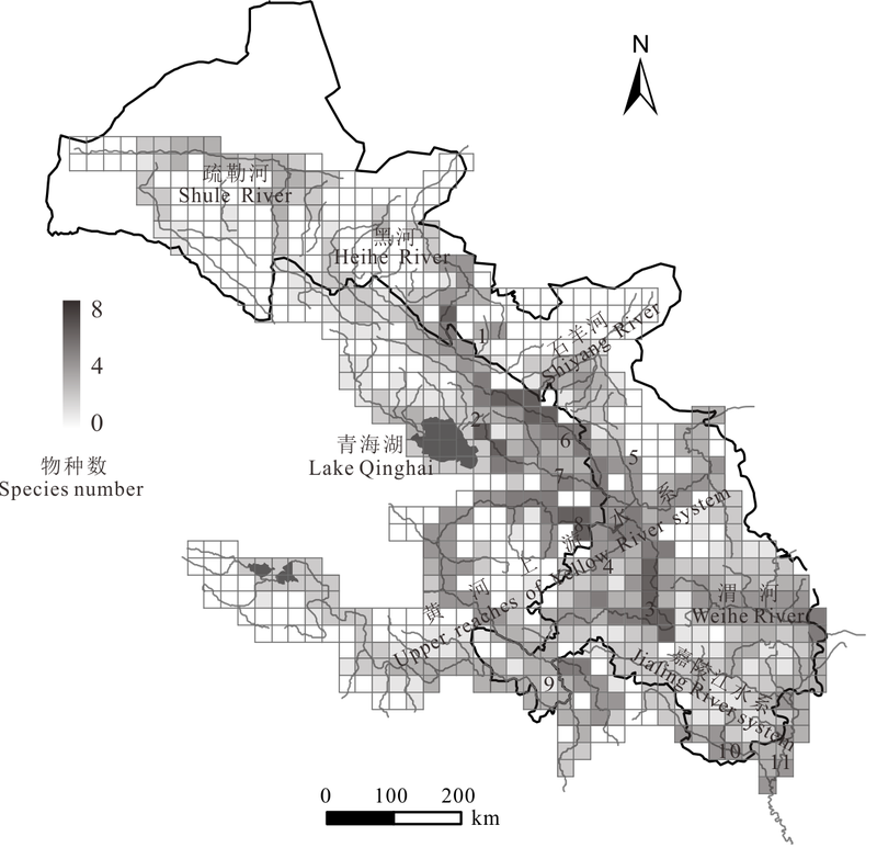
图3 青藏高原东北部边缘地区高原鳅属鱼类物种丰富度分布格局, 图中河流编号与图1中一致。
Fig. 3 The species richness pattern of Triplophysa species in northeastern margin of Tibetan Plateau, serial number in accordance with Fig. 1.
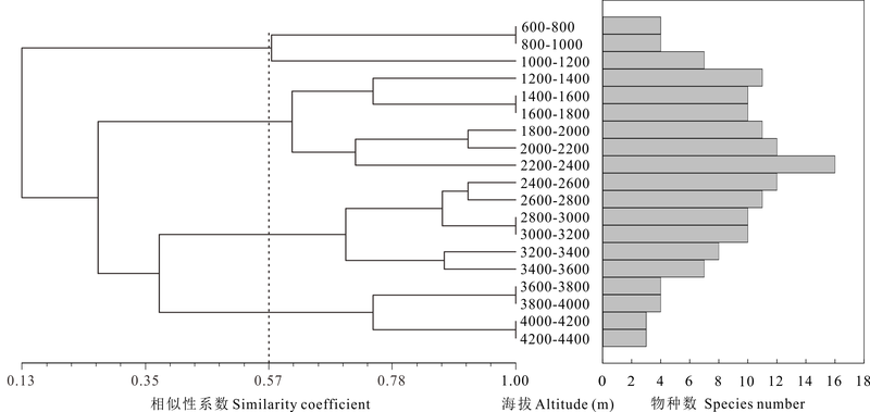
图4 青藏高原东北部边缘地区高原鳅属鱼类物种丰富度的海拔分布格局
Fig. 4 Elevational distribution pattern of species richness of Triplophysa in northeastern margin of Tibetan Plateau
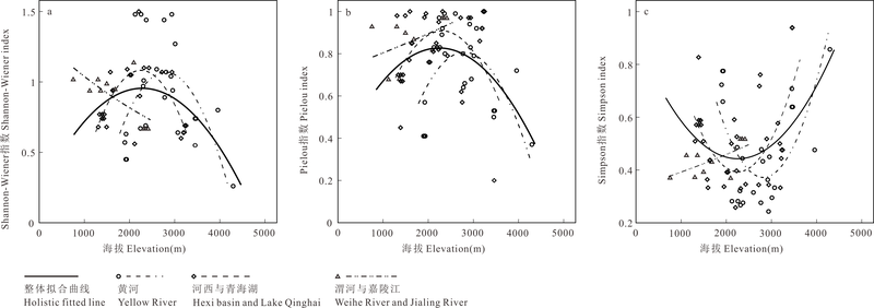
图5 生物多样性指数与海拔的关系
Fig. 5 The relationship between biodiversity indices and elevation
| 1 | Chen YY, Chen YF, Liu HZ (1996) Studies on the position of the Qinghai-Xizang Plateau region in zoogeographic divisions and its eastern demarcation line. Acta Hydrobiologica Sinica, 20, 97-103. (in Chinese with English abstract) |
| [陈宜瑜, 陈毅峰, 刘焕章 (1996) 青藏高原动物地理区的地位和东部界线问题. 水生生物学报, 20, 97-103.] | |
| 2 | Ding RH (1994) The Fishes of Sichuan . Sichuan Publishing House of Science and Technology, Chengdu. (in Chinese) |
| [丁瑞华 (1994) 四川鱼类志. 四川科学技术出版社, 成都.] | |
| 3 | Dong ZR, Sun DY, Zhao JY, Zhang J (2010) Holistic conceptual model for the structure and function of river ecosystems. Advances in Water Science, 21, 550-559. (in Chinese with English abstract) |
| [董哲仁, 孙东亚, 赵进勇, 张晶 (2010) 河流生态系统结构功能整体性概念模型. 水科学进展, 21, 550-559.] | |
| 4 | Fu CZ, Wu JH, Chen JK, Wu QH, Lei GC (2003) Freshwater fish biodiversity in the Yangtze River basin of China: patterns, threats and conservation. Biodiversity and Conservation, 12, 1649-1685. |
| 5 | Fu CZ, Wu JH, Wang XY, Lei GC, Chen JK (2004) Patterns of diversity, altitudinal range and body size among freshwater fishes in the Yangtze River basin, China. Global Ecology and Biogeography, 13, 543-552. |
| 6 | Ge F (2002) Modern Ecology. Science Press, Beijing. (in Chinese) |
| [戈峰 (2002) 现代生态学. 科学出版社, 北京.] | |
| 7 | He CL, Song ZB, Zhang E (2011) Triplophysa fishes in China and the status of its taxonomic studies. Sichuan Journal of Zoology, 30, 150-155. (in Chinese with English abstract) |
| [何春林, 宋昭彬, 张鹗 (2011) 中国高原鳅属鱼类及其分类研究现状. 四川动物, 30, 150-155.] | |
| 8 | He DK, Chen YX, Chen YF (2006) The molecular phylogeny and biogeography of genus Triplophysa. Progress in Natural Science, 16, 1395-1404. (in Chinese with English abstract) |
| [何德奎, 陈咏霞, 陈毅峰 (2006) 高原鳅属Triplophysa鱼类的分子系统发育和生物地理学研究. 自然科学进展, 16, 1395-1404.] | |
| 9 | He DK, Chen YF (2007) Molecular phylogeny and biogeography of the highly specialized grade schizothoracine fishes. Chinese Science Bulletin, 52, 303-312. (in Chinese with English abstract) |
| [何德奎, 陈毅峰 (2007) 高度特化等级裂腹鱼类的分子系统发育与生物地理学. 科学通报, 52, 303-312.] | |
| 10 | Jaccard P (1901) Distribution de la flore alpine dans le Bassin des Dranes et dans quelques régions voisines. Bulletin Société Vaudoise des Science Naturelles, 37, 241-272. |
| 11 | Liu Z, Li Q, Chen DD, Zhai WT, Zhao L, Xu SX, Zhao XQ (2015) Patterns of plant species diversity along an altitudinal gradient and its effect on above-ground biomass in alpine meadows in Qinghai-Tibet Plateau. Biodiversity Science, 23, 451-462. (in Chinese with English abstract) |
| [刘哲, 李奇, 陈懂懂, 翟文婷, 赵亮, 徐世晓, 赵新全 (2015) 青藏高原高寒草甸物种多样性的海拔梯度分布格局及对地上生物量的影响. 生物多样性, 23, 451-462.] | |
| 12 | Lomolino MV (2001) Elevation gradients of species-density: historical and prospective views. Global Ecology and Biogeography, 10, 3-13. |
| 13 | Ma J, Wu YJ, Xia L, Zhang Q, Ma Y, Yang QS (2010) Elevational diversity of small mammals in Luoji Mt. Nature Reserve, Sichuan Province. Acta Theriologica Sinica, 30, 400-410. (in Chinese with English abstract) |
| [马俊, 吴永杰, 夏霖, 张乾, 马勇, 杨奇森 (2010) 螺髻山自然保护区非飞行小型哺乳动物垂直多样性调查. 兽类学报, 30, 400-410.] | |
| 14 | Myers N, Mittermeier RA, Mittermeier CG, da Fonseca GAB, Kent J (2000) Biodiversity hotspots for conservation priorities. Nature, 403, 853-858. |
| 15 | Parmesan C (2006) Ecological and evolutionary responses to recent climates change. Annual Review of Ecology, Evolution, and Systematics, 37, 637-669. |
| 16 | Pielou EC (1975) Ecological Diversity. Wiley, New York. |
| 17 | Prendergast JR, Quinn RM, Lawton JH, Eversham BC, Gibbons DW (1993) Rare species, the coincidence of diversity hotspots and conservation strategies. Nature, 365, 335-337. |
| 18 | Shannon EC, Weaver W (1949) The Mathematical Theory of Communication. Urbana University of Illinois Press, Illinois. |
| 19 | Vetaas OR, Grytnes JA (2002) Distribution of vascular plant species richness and endemic richness along the Himalayan elevation gradient in Nepal. Global Ecology and Biogeography, 11, 291-301. |
| 20 | Wang T, Zhang YP, Guan LH, Du YY, Lou ZY, Jiao WL (2015) Current freshwater fish resources and the application of DNA barcoding in species identification in Gansu Province. Biodiversity Science, 23, 306-313. (in Chinese with English abstract) |
| [王太, 张艳萍, 管丽红, 杜岩岩, 娄忠玉, 焦文龙 (2015) 甘肃省鱼类资源现状及DNA条形码在鱼类物种鉴定中的应用. 生物多样性, 23, 306-313.] | |
| 21 | Wang XT (1991) Vertebrate Fauna of Gansu. Gansu Science and Technology Press, Lanzhou. (in Chinese) |
| [王香亭 (1991) 甘肃省脊椎动物志. 甘肃科学技术出版社, 兰州.] | |
| 22 | Williams PH, Humphries CJ, Vane-Wright RI (1991) Measuring biodiversity: taxonomic relatedness for conservation priorities. Australian Systematic Botany, 4, 665-679. |
| 23 | Wu YF, Wu CZ (1990) A preliminary study of the fishery resources and the countermeasures of fishery development in |
| 24 | the region of the Karakorum-Kunlun Mountains, China. Journal of Natural Resources, 5, 354-364. (in Chinese with English abstract) |
| [武云飞, 吴翠珍 (1990) 喀喇昆仑山-昆仑山地区渔业资源及渔业发展对策的初步研究. 自然资源学报, 5, 354-364.] | |
| 25 | Wu YF, Wu CZ (1992) The Fishes of the Qinghai-Xizang Plateau. Sichuan Publishing House of Science & Technology, Chengdu. (in Chinese) |
| [武云飞, 吴翠珍 (1992) 青藏高原鱼类. 四川科学技术出版社, 成都.] | |
| 26 | Wu YJ, Yang QS, Xia L, Feng ZJ, Zhou HM (2012) Species diversity and distribution pattern of non-volant small mammals along the elevational gradient on eastern slope of Gongga Mountain. Acta Ecologica Sinica, 32, 4318-4328. (in Chinese with English abstract) |
| [吴永杰, 杨奇森, 夏霖, 冯祚建, 周华明 (2012) 贡嘎山东坡非飞行小型兽类物种多样性的垂直分布格局. 生态学报, 32, 4318-4328.] | |
| 27 | Yang YT, Zhang YM (1991) Study on fishes’ fauna and evolution of the Inland River, Hexi Corridor. Journal of Lanzhou University (Natural Sciences), 27, 141-144. (in Chinese with English abstract) |
| [杨友桃, 张迎梅 (1991) 河西走廊鱼类区系及其演变的研究. 兰州大学学报(自然科学版), 27, 141-144.] | |
| 28 | Zhang YY, Zhou LZ, Wang QS, Wang XJ, Xing YJ (2008) Distribution pattern and hotspot analysis of breeding birds in Anhui Province. Biodiversity Science, 16, 305-312. (in Chinese with English abstract) |
| [张有瑜, 周立志, 王岐山, 王新建, 邢雅俊 (2008) 安徽省繁殖鸟类分布格局和热点区分析. 生物多样性, 16, 305-312.] | |
| 29 | Zhao K (2009) Adaptive Evolution and Biogeography in the Schizothoracine Fish (Cyprinidae) Endemic to the Northeast Tibetan Plateau. Postdoctoral research report, Northwest Institute of Plateau Biology, Chinese Academy of Sciences, Xining. (in Chinese with English abstract) |
| [赵凯 (2009) 东北部青藏高原特有裂腹鱼类的适应性进化和生物地理学研究. 博士后研究工作报告, 中国科学院西北高原生物研究所, 西宁.] | |
| 30 | Zheng Z, Gong DJ, Sun CX, Li XJ, Li WJ (2014) Elevational pattern of amphibian and reptile diversity in Qinling Range and explanation. Biodiversity Science, 22, 596-607. (in Chinese with English abstract) |
| [郑智, 龚大洁, 孙呈祥, 李晓军, 李万江 (2014) 秦岭两栖、爬行动物物种多样性海拔分布格局及其解释. 生物多样性, 22, 596-607.] | |
| 31 | Zhu SQ (1989) The Loaches of the Subfamily Nemacheilinae in China. Jiangsu Science and Technology Publishing House, Nanjing. (in Chinese) |
| [朱松泉 (1989) 中国条鳅志. 江苏科学技术出版社, 南京.] |
| [1] | 吴晓晴 张美惠 葛苏婷 李漫淑 宋坤 沈国春 达良俊 张健. 上海近自然林重建过程中木本植物物种多样性与地上生物量的时空动态——以闵行区生态岛为例[J]. 生物多样性, 2025, 33(5): 24444-. |
| [2] | 干靓 刘巷序 鲁雪茗 岳星. 全球生物多样性热点地区大城市的保护政策与优化方向[J]. 生物多样性, 2025, 33(5): 24529-. |
| [3] | 曾子轩 杨锐 黄越 陈路遥. 清华大学校园鸟类多样性特征与环境关联[J]. 生物多样性, 2025, 33(5): 24373-. |
| [4] | 周昊, 王茗毅, 张楚格, 肖治术, 欧阳芳. 昆虫旅馆在独栖蜂多样性保护中的现状与挑战[J]. 生物多样性, 2025, 33(5): 24472-. |
| [5] | 臧明月, 刘立, 马月, 徐徐, 胡飞龙, 卢晓强, 李佳琦, 于赐刚, 刘燕. 《昆明-蒙特利尔全球生物多样性框架》下的中国城市生物多样性保护[J]. 生物多样性, 2025, 33(5): 24482-. |
| [6] | 祝晓雨, 王晨灏, 王忠君, 张玉钧. 城市绿地生物多样性研究进展与展望[J]. 生物多样性, 2025, 33(5): 25027-. |
| [7] | 袁琳, 王思琦, 侯静轩. 大都市地区的自然留野:趋势与展望[J]. 生物多样性, 2025, 33(5): 24481-. |
| [8] | 胡敏, 李彬彬, Coraline Goron. 只绿是不够的: 一个生物多样性友好的城市公园管理框架[J]. 生物多样性, 2025, 33(5): 24483-. |
| [9] | 王欣, 鲍风宇. 基于鸟类多样性提升的南滇池国家湿地公园生态修复效果分析[J]. 生物多样性, 2025, 33(5): 24531-. |
| [10] | 明玥, 郝培尧, 谭铃千, 郑曦. 基于城市绿色高质量发展理念的中国城市生物多样性保护与提升研究[J]. 生物多样性, 2025, 33(5): 24524-. |
| [11] | 徐欢, 辛凤飞, 施宏亮, 袁琳, 薄顺奇, 赵欣怡, 邓帅涛, 潘婷婷, 余婧, 孙赛赛, 薛程. 生态修复技术集成应用对长江口北支生境与鸟类多样性提升效果评估[J]. 生物多样性, 2025, 33(5): 24478-. |
| [12] | 易木荣, 卢萍, 彭勇, 汤勇, 许久恒, 尹浩萍, 张路杨, 翁晓东, 底明晓, 雷隽, 卢宸祺, 曹如君, 戴年华, 占德洋, 童媚, 楼智明, 丁永刚, 柴静, 车静. 北潦河金家水支流江西大鲵野外种群现状及栖息地评估[J]. 生物多样性, 2025, 33(4): 24145-. |
| [13] | 谢淦, 宣晶, 付其迪, 魏泽, 薛凯, 雒海瑞, 高吉喜, 李敏. 草地植物多样性无人机调查的物种智能识别模型构建[J]. 生物多样性, 2025, 33(4): 24236-. |
| [14] | 王太, 宋福俊, 张永胜, 娄忠玉, 张艳萍, 杜岩岩. 河西走廊内陆河水系鱼类多样性及资源现状[J]. 生物多样性, 2025, 33(4): 24387-. |
| [15] | 褚晓琳, 张全国. 演化速率假说的实验验证研究进展[J]. 生物多样性, 2025, 33(4): 25019-. |
| 阅读次数 | ||||||
|
全文 |
|
|||||
|
摘要 |
|
|||||
备案号:京ICP备16067583号-7
Copyright © 2026 版权所有 《生物多样性》编辑部
地址: 北京香山南辛村20号, 邮编:100093
电话: 010-62836137, 62836665 E-mail: biodiversity@ibcas.ac.cn
![]()