
Biodiv Sci ›› 2023, Vol. 31 ›› Issue (3): 22430. DOI: 10.17520/biods.2022430 cstr: 32101.14.biods.2022430
Special Issue: 青藏高原生物多样性与生态安全
• Original Papers: Plant Diversity • Previous Articles Next Articles
Jiawen Sang1,2, Chuangye Song1,*( ), Ningxia Jia1,2, Yuan Jia1,2, Changcheng Liu1, Xianguo Qiao1, Lin Zhang1, Weiying Yuan1, Dongxiu Wu1, Linghao Li1, Ke Guo1,*()
Received:2022-07-26
Accepted:2022-12-05
Online:2023-03-20
Published:2023-03-28
Contact:
Chuangye Song,Ke Guo
Jiawen Sang, Chuangye Song, Ningxia Jia, Yuan Jia, Changcheng Liu, Xianguo Qiao, Lin Zhang, Weiying Yuan, Dongxiu Wu, Linghao Li, Ke Guo. Vegetation survey and mapping on the Qinghai-Tibet Plateau[J]. Biodiv Sci, 2023, 31(3): 22430.
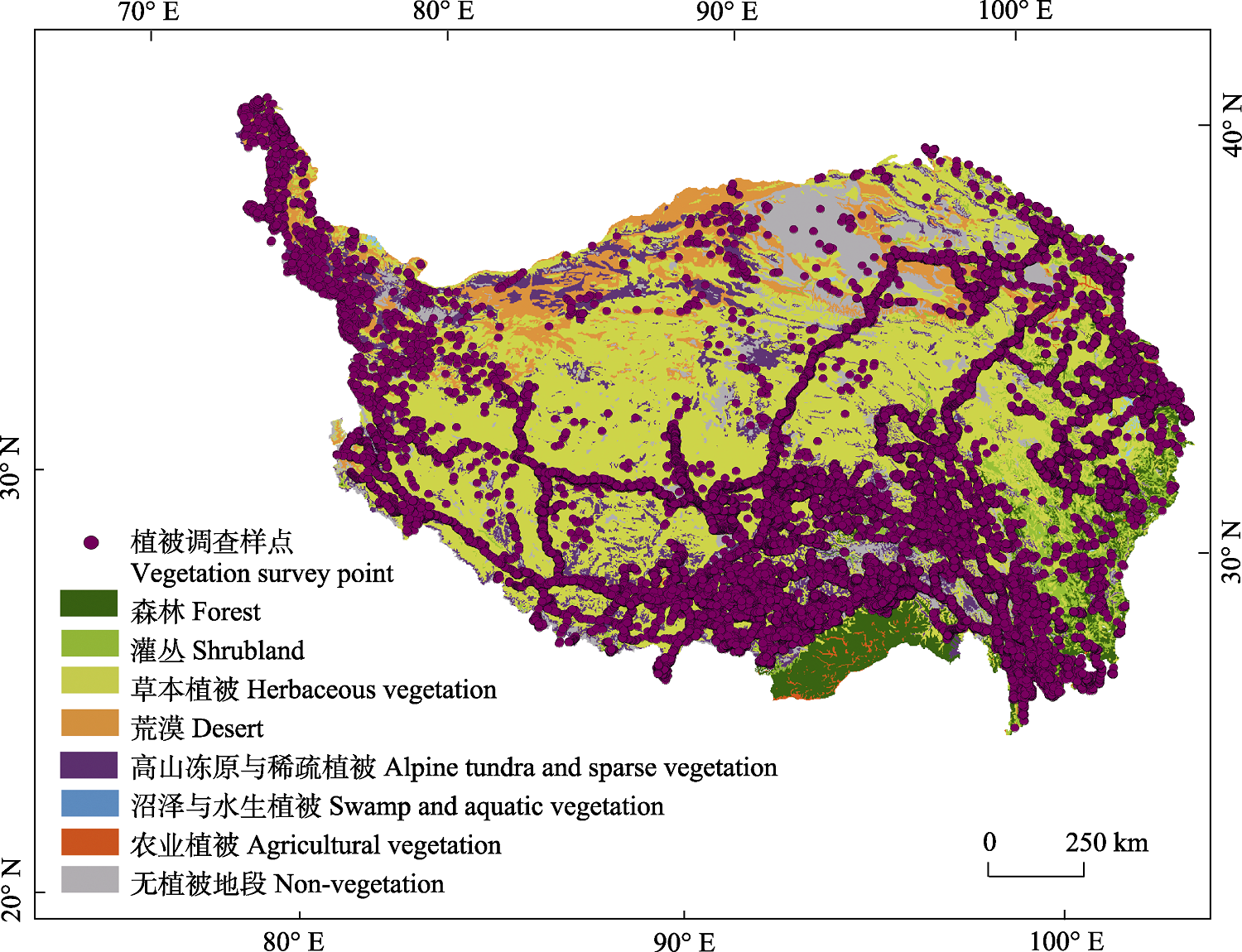
Fig. 1 Distribution of vegetation survey points on the Qinghai-Tibet Plateau (in China). The data of vegetation survey points comes from the project of “Forest and shrub ecosystem and resource management” in the Second Qinghai-Tibet Plateau Scientific Expedition and Research Program; The vegetation type data comes from the Vegetation Map of China (1 : 1,000,000) (Editorial Committee of Vegetation Map of China, Chinese Academy of Sciences, 2007).
| 草本植被 Herb | 荒漠 Desert | 沼泽与水生植被 Swamp | |
|---|---|---|---|
| 样点数 No. of points* | 350,335 | 27,669 | 889 |
| 相吻合样点数量 No. of consistency points | 265,689 | 12,571 | 257 |
| 相吻合样点比率 Ratio of consistency points | 75.84% | 45.43% | 28.91% |
Table 1 Consistency comparison of the Grassland Resource Map of China (1 : 1,000,000) with that of the Vegetation Map of China (1 : 1,000,000) at vegetation formation group level
| 草本植被 Herb | 荒漠 Desert | 沼泽与水生植被 Swamp | |
|---|---|---|---|
| 样点数 No. of points* | 350,335 | 27,669 | 889 |
| 相吻合样点数量 No. of consistency points | 265,689 | 12,571 | 257 |
| 相吻合样点比率 Ratio of consistency points | 75.84% | 45.43% | 28.91% |
| 森林 Forest | 灌丛 Shrubland | 草本植被 Herb | 高山植被 Alpine | 沼泽植被 Swamp | 农业植被 Agricultural vegetation | 无植被地段 Non-vegetation | |
|---|---|---|---|---|---|---|---|
| 样点数 No. of points* | 41,100 | 47,577 | 357,118 | 71,761 | 1,318 | 3,783 | 68,489 |
| 相吻合样点数量 No. of consistency points | 29,784 | 1,308 | 268,271 | 30,298 | 13 | 682 | 43,730 |
| 相吻合样点比率 Ratio of consistency points | 72.47% | 2.75% | 75.12% | 42.22% | 0.99% | 18.03% | 63.85% |
Table 2 Consistency comparison of Vegetation Map of China (1:1,000,000) with that of the Current Vegetation Map of Qinghai-Tibet Plateau at vegetation formation group level
| 森林 Forest | 灌丛 Shrubland | 草本植被 Herb | 高山植被 Alpine | 沼泽植被 Swamp | 农业植被 Agricultural vegetation | 无植被地段 Non-vegetation | |
|---|---|---|---|---|---|---|---|
| 样点数 No. of points* | 41,100 | 47,577 | 357,118 | 71,761 | 1,318 | 3,783 | 68,489 |
| 相吻合样点数量 No. of consistency points | 29,784 | 1,308 | 268,271 | 30,298 | 13 | 682 | 43,730 |
| 相吻合样点比率 Ratio of consistency points | 72.47% | 2.75% | 75.12% | 42.22% | 0.99% | 18.03% | 63.85% |
| 植被图 Vegetation map | 分类单元 Units of classification | 斑块数量 No. of patches | 面积 Area (km2) |
|---|---|---|---|
| 《1 : 400万中国植被图》Vegetation Map of China (1 : 4,000,000) | 草甸和草本沼泽 Meadows and herbaceous swamp | 98 | 446,241.2 |
| 草原和稀树灌木草原 Grassland and sparse shrub grassland | 97 | 595,161.2 | |
| 荒漠 Desert | 57 | 649,758.2 | |
| 灌丛和萌生矮林 Shrubland and brushwood | 294 | 576,196.3 | |
| 《1 : 100万中国植被图》Vegetation Map of China (1 : 1,000,000) | 草丛 Tussock | 72 | 3,597.9 |
| 草原 Grassland | 1,295 | 717,883.9 | |
| 草甸 Meadow | 2,755 | 720,985.4 | |
| 灌丛 Shubland | 2,321 | 195,163.2 | |
| 荒漠 Desert | 665 | 250,867.2 | |
| 沼泽 Swamp | 70 | 5,773.7 | |
| 《1 : 100万中国草地资源图》 Grassland Resource Map of China (1 : 1,000,000) | 草丛 Tussock1 | 69 | 1,039.9 |
| 草原 Grassland2 | 2,922 | 655,195.2 | |
| 草甸 Meadow3 | 8,744 | 709,558.7 | |
| 改良草地 Improved grassland | 44 | 321.5 | |
| 灌草丛 Shrubby tussock4 | 233 | 6,140.3 | |
| 荒漠 Desert5 | 505 | 124,494.2 | |
| 沼泽 Swamp | 85 | 3,427.9 | |
| 《青藏高原现状植被图》 Current Vegetation Map of Qinghai-Tibet Plateau | 灌丛 Shrubland | 35,368 | 3,867.9 |
| 草本植被 Herbaceous vegetation | 357,454 | 1,541,392.69 | |
| 沼泽 Swamp | 7,776 | 762.61 |
Table 3 Comparison of herbaceous vegetation classification and patch number on the Qinghai-Tibet Plateau among Vegetation Map of China (1 : 4,000,000), Grassland Resource Map of China (1 : 1,000,000) and Vegetation Map of China (1 : 1,000,000)
| 植被图 Vegetation map | 分类单元 Units of classification | 斑块数量 No. of patches | 面积 Area (km2) |
|---|---|---|---|
| 《1 : 400万中国植被图》Vegetation Map of China (1 : 4,000,000) | 草甸和草本沼泽 Meadows and herbaceous swamp | 98 | 446,241.2 |
| 草原和稀树灌木草原 Grassland and sparse shrub grassland | 97 | 595,161.2 | |
| 荒漠 Desert | 57 | 649,758.2 | |
| 灌丛和萌生矮林 Shrubland and brushwood | 294 | 576,196.3 | |
| 《1 : 100万中国植被图》Vegetation Map of China (1 : 1,000,000) | 草丛 Tussock | 72 | 3,597.9 |
| 草原 Grassland | 1,295 | 717,883.9 | |
| 草甸 Meadow | 2,755 | 720,985.4 | |
| 灌丛 Shubland | 2,321 | 195,163.2 | |
| 荒漠 Desert | 665 | 250,867.2 | |
| 沼泽 Swamp | 70 | 5,773.7 | |
| 《1 : 100万中国草地资源图》 Grassland Resource Map of China (1 : 1,000,000) | 草丛 Tussock1 | 69 | 1,039.9 |
| 草原 Grassland2 | 2,922 | 655,195.2 | |
| 草甸 Meadow3 | 8,744 | 709,558.7 | |
| 改良草地 Improved grassland | 44 | 321.5 | |
| 灌草丛 Shrubby tussock4 | 233 | 6,140.3 | |
| 荒漠 Desert5 | 505 | 124,494.2 | |
| 沼泽 Swamp | 85 | 3,427.9 | |
| 《青藏高原现状植被图》 Current Vegetation Map of Qinghai-Tibet Plateau | 灌丛 Shrubland | 35,368 | 3,867.9 |
| 草本植被 Herbaceous vegetation | 357,454 | 1,541,392.69 | |
| 沼泽 Swamp | 7,776 | 762.61 |
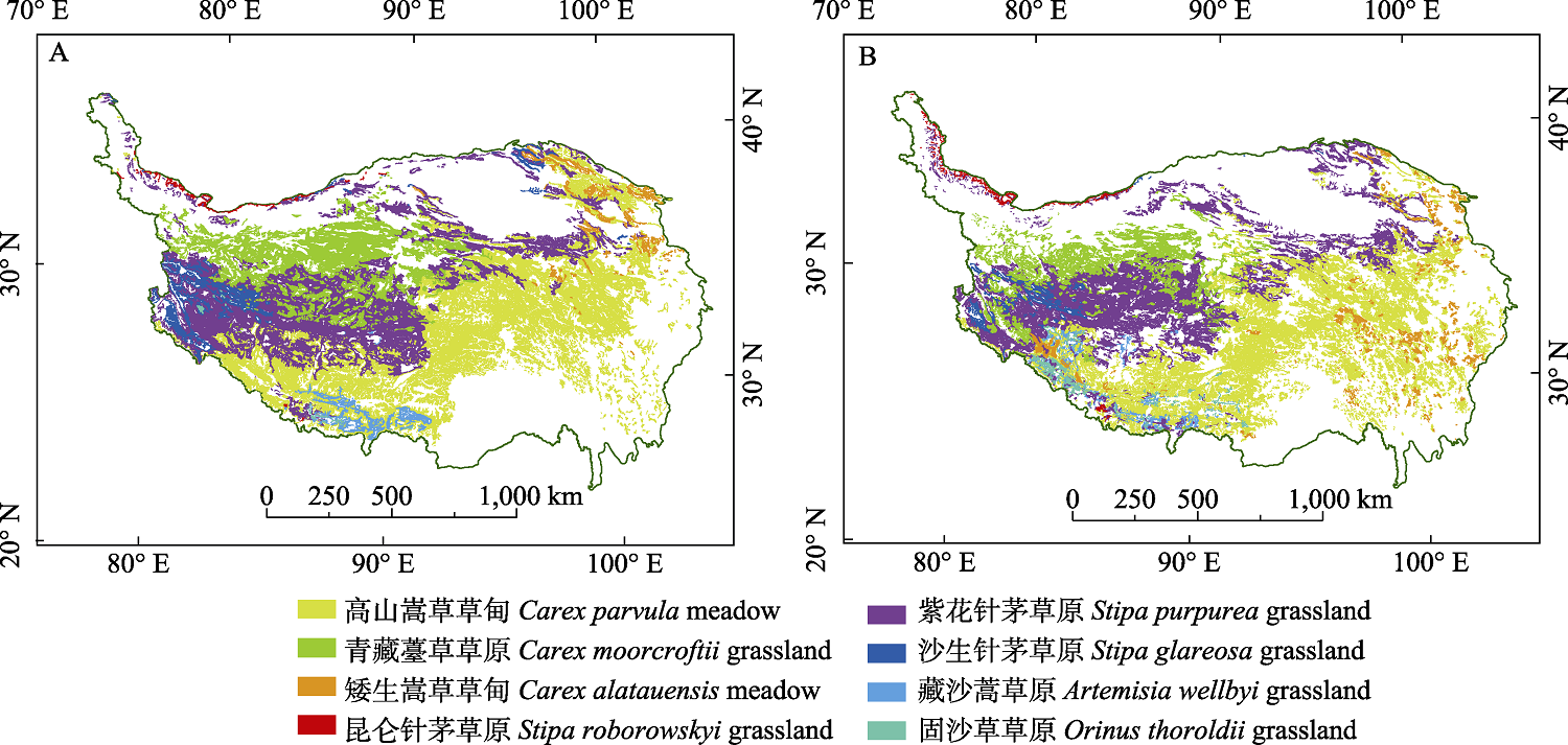
Fig. 2 Distribution of eight typical herbaceous vegetation types on the Qinghai-Tibet Plateau in the Vegetation Map of China (1 : 1,000,000) (A) and the Grassland Resource Map of China (1 : 1,000,000) (B)
| 群系类型 Formation | 《1 : 100万中国植被图》 Vegetation Map of China (1 : 1,000,000) | 《1 : 100万中国草地资源图》 Grassland Resource Map of China (1 : 1,000,000) | ||
|---|---|---|---|---|
| 斑块数量 No. of patches | 面积 Area (km2) | 斑块数量 No. of patches | 面积 Area (km2) | |
| 高山嵩草草甸 Carex parvula meadow | 1,073 | 464,766.8 | 3,194 | 352,648.4 |
| 紫花针茅草原 Stipa purpurea grassland | 537 | 381,227.9 | 1,178 | 374,534.2 |
| 青藏薹草草原 Carex moorcroftii grassland | 302 | 197,173.0 | 293 | 116,793.2 |
| 沙生针茅草原 Stipa glareosa grassland | 53 | 42,523.1 | 66 | 19,247.6 |
| 矮生嵩草草甸 Carex alatauensis meadow | 87 | 25,190.0 | 360 | 35,581.8 |
| 藏沙蒿草原 Artemisia wellbyi grassland | 34 | 21,243.4 | 138 | 25,718.6 |
| 昆仑针茅草原 Stipa roborowskyi grassland | 37 | 6,167.2 | 117 | 9,155.3 |
| 固沙草草原 Orinus thoroldii grassland | 21 | 1,981.1 | 95 | 11,930.5 |
Table 4 Comparison of patch number and area of eight typical herbaceous vegetation types on the Qinghai-Tibet Plateau among different vegetation maps
| 群系类型 Formation | 《1 : 100万中国植被图》 Vegetation Map of China (1 : 1,000,000) | 《1 : 100万中国草地资源图》 Grassland Resource Map of China (1 : 1,000,000) | ||
|---|---|---|---|---|
| 斑块数量 No. of patches | 面积 Area (km2) | 斑块数量 No. of patches | 面积 Area (km2) | |
| 高山嵩草草甸 Carex parvula meadow | 1,073 | 464,766.8 | 3,194 | 352,648.4 |
| 紫花针茅草原 Stipa purpurea grassland | 537 | 381,227.9 | 1,178 | 374,534.2 |
| 青藏薹草草原 Carex moorcroftii grassland | 302 | 197,173.0 | 293 | 116,793.2 |
| 沙生针茅草原 Stipa glareosa grassland | 53 | 42,523.1 | 66 | 19,247.6 |
| 矮生嵩草草甸 Carex alatauensis meadow | 87 | 25,190.0 | 360 | 35,581.8 |
| 藏沙蒿草原 Artemisia wellbyi grassland | 34 | 21,243.4 | 138 | 25,718.6 |
| 昆仑针茅草原 Stipa roborowskyi grassland | 37 | 6,167.2 | 117 | 9,155.3 |
| 固沙草草原 Orinus thoroldii grassland | 21 | 1,981.1 | 95 | 11,930.5 |
| 森林 Forest | 灌丛 Shrubland | 草本植被 Herb | 荒漠 Desert | 高山植被 Alpine | 沼泽植被 Swamp | 农业植被 Agricultural vegetation | 无植被地段 Non-vegetation | ||
|---|---|---|---|---|---|---|---|---|---|
| 植被调查样点数量 No. of vegetation survey points | 55,073 | 35,636 | 22,494 | 1,822 | 1,245 | 21 | 2,339 | 922 | |
| 《1 : 100万中国植被图》 Vegetation Map of China (1 : 1,000,000) | 相吻合样点数量 No. of consistency points | 36,656 | 9,593 | 15,830 | 1,163 | 625 | 1 | 304 | 448 |
| 吻合样点比率 Ratio of consistency points | 66.56% | 26.92% | 70.37% | 63.83% | 50.20% | 4.76% | 13.00% | 48.59% | |
| 《1 : 100万中国草地资源图》 Grassland Resource Map of China (1 : 1,000,000) | 相吻合样点数量 No. of consistency points | ? | ? | 20,541 | 907 | ? | 0 | ? | ? |
| 吻合样点比率 Ratio of consistency points | ? | ? | 91.30% | 49.80% | ? | 0 | ? | ? | |
| 《青藏高原现状植被图》 Current Vegetation Map of Qinghai-Tibet Plateau | 相吻合样点数量 No. of consistency points | 36,059 | 403 | 20,644 | ? | 373 | 0 | 575 | 727 |
| 吻合样点比率 Ratio of consistency points | 65.47% | 1.13% | 91.78% | ? | 29.96% | 0 | 24.58% | 78.85% | |
Table 5 Consistency comparison of vegetation survey points with that of the Vegetation Map of China (1 : 1,000,000), the Grassland Resource Map of China (1 : 1,000,000) and the Current Vegetation Map of Qinghai-Tibet Plateau at vegetation formation group level
| 森林 Forest | 灌丛 Shrubland | 草本植被 Herb | 荒漠 Desert | 高山植被 Alpine | 沼泽植被 Swamp | 农业植被 Agricultural vegetation | 无植被地段 Non-vegetation | ||
|---|---|---|---|---|---|---|---|---|---|
| 植被调查样点数量 No. of vegetation survey points | 55,073 | 35,636 | 22,494 | 1,822 | 1,245 | 21 | 2,339 | 922 | |
| 《1 : 100万中国植被图》 Vegetation Map of China (1 : 1,000,000) | 相吻合样点数量 No. of consistency points | 36,656 | 9,593 | 15,830 | 1,163 | 625 | 1 | 304 | 448 |
| 吻合样点比率 Ratio of consistency points | 66.56% | 26.92% | 70.37% | 63.83% | 50.20% | 4.76% | 13.00% | 48.59% | |
| 《1 : 100万中国草地资源图》 Grassland Resource Map of China (1 : 1,000,000) | 相吻合样点数量 No. of consistency points | ? | ? | 20,541 | 907 | ? | 0 | ? | ? |
| 吻合样点比率 Ratio of consistency points | ? | ? | 91.30% | 49.80% | ? | 0 | ? | ? | |
| 《青藏高原现状植被图》 Current Vegetation Map of Qinghai-Tibet Plateau | 相吻合样点数量 No. of consistency points | 36,059 | 403 | 20,644 | ? | 373 | 0 | 575 | 727 |
| 吻合样点比率 Ratio of consistency points | 65.47% | 1.13% | 91.78% | ? | 29.96% | 0 | 24.58% | 78.85% | |
| [1] |
Bajracharya B, Uddin K, Chettri N, Shrestha B, Siddiqui SA (2010) Understanding land cover change using a harmonized classification system in the Himalaya: A case study from Sagarmatha National Park, Nepal. Mountain Research and Development, 30, 143-156.
DOI URL |
| [2] | Chen LZ, Sun H, Guo K (2014) Flora and Vegetation Geography of China. Science Press, Beijing. (in Chinese) |
| [陈灵芝, 孙航, 郭柯 (2014) 中国植物区系与植被地理. 科学出版社, 北京.] | |
| [3] | Cheng G, Wu T (2007) Responses of permafrost to climate change and their environmental significance, Qinghai-Tibet Plateau. Journal of Geophysical Research, 112, F02S03. |
| [4] | China Meteorological Administration (2022) Climate Change Blue Book of China. Science Press, Beijing. (in Chinese) |
| [中国气象局 (2022) 中国气候变化蓝皮书. 科学出版社, 北京.] | |
| [5] | Editorial Board of Sanjiangyuan Natural Ecological Environment (2002) Ecological Environment of Sanjiangyuan Nature Reserve. Qinghai People’s Publishing House, Xining. (in Chinese) |
| [《三江源自然保护区生态环境》编辑委员会 (2002) 三江源自然保护区生态环境. 青海人民出版社, 西宁.] | |
| [6] | Editorial Committee of 1 : 1,000,000 Grassland Resources Map of China (1993) 1 : 1,000,000 Atlas of Grassland Resources in China. Sino Maps Press, Beijing. (in Chinese) |
| [[1 : 1,000,000中国草地资源图编制委 (1993) 1 : 1,000,000中国草地资源图集. 中国地图出版社, 北京.] | |
| [7] | Editorial Committee of Vegetation Map of China, Chinese Academy of Sciences (2007) Vegetation Map of the People’s Republic of China (1 : 1,000,000). Geologica Publishing House, Beijing. (in Chinese) |
| [[中国科学院中国植被图编辑委员会 (2007) 中华人民共和国植被图(1 : 1,000,000). 地质出版社, 北京.] | |
| [8] |
Fang JY, Wang GH (2020) Vegegraphy of China: Surveying and describing the country’s vegetation. Chinese Journal of Plant Ecology, 44, 93-95. (in Chinese)
DOI URL |
|
[方精云, 王国宏 (2020) 《中国植被志》: 为中国植被登记造册. 植物生态学报, 44, 93-95.]
DOI |
|
| [9] |
Fang K, Gou X, Chen F, Peng J, D’Arrigo R, Wright W, Li MH (2009) Response of regional tree-line forests to climate change: Evidence from the northeastern Tibetan Plateau. Trees, 23, 1321-1329.
DOI URL |
| [10] |
Gou X, Zhang F, Deng Y, Ettl GJ, Yang M, Gao L, Fang K (2012) Patterns and dynamics of tree-line response to climate change in the eastern Qilian Mountains, northwestern China. Dendrochronologia, 30, 121-126.
DOI URL |
| [11] |
Guo K, Fang JY, Wang GH, Tang ZY, Xie ZQ, Shen ZH, Wang RQ, Qiang S, Liang CZ, Da LJ, Yu D (2020) A revised scheme of vegetation classification system of China. Chinese Journal of Plant Ecology, 44, 111-127. (in Chinese with English abstract)
DOI |
|
[郭柯, 方精云, 王国宏, 唐志尧, 谢宗强, 沈泽昊, 王仁卿, 强胜, 梁存柱, 达良俊, 于丹 (2020) 中国植被分类系统修订方案. 植物生态学报, 44, 111-127.]
DOI |
|
| [12] |
Guo QH, Guan HC, Hu TY, Jin SC, Su YJ, Wang XJ, Wei DJ, Ma Q, Sun QH (2021) Remote sensing-based mapping for the new generation of Vegetation Map of China (1 : 500,000). Scientia Sinica Vitae, 51, 229-241. (in Chinese with English abstract)
DOI URL |
| [郭庆华, 关宏灿, 胡天宇, 金时超, 苏艳军, 王雪静, 魏邓杰, 马勤, 孙千惠 (2021) 新一代1 : 50万中国植被图绘制方法探讨. 中国科学: 生命科学, 51, 229-241.] | |
| [13] |
Guo W, Ni XN, Jing DY, Li SH (2014) Spatial-temporal patterns of vegetation dynamics and their relationships to climate variations in Qinghai Lake Basin using MODIS time-series data. Journal of Geographical Sciences, 24, 1009-1021.
DOI |
| [14] | Hou XY (1960) Vegetation in China. People’s Education Press, Beijing. (in Chinese) |
| [侯学煜 (1960) 中国的植被. 人民教育出版社, 北京.] | |
| [15] | Hou XY, Hu SZ, Chen CD (1965) The Vegetation Map of China (1 : 10,000,000) and its Its Instructions//The Natural Atlas of the People's Republic of China. The National Atlas Editorial Committee, Beijing. (in Chinese) |
| [侯学煜, 胡式之, 陈昌笃 (1965) 中国植被图(1 : 1,000万)及其说明书//中华人民共和国自然地图集. 国家地图集编辑委员会, 北京.] | |
| [16] | Hou XY, Ma RZ (1956) Map of Vegetation, Zoning Soil in China (1 : 4,000,000). Sino Maps Press, Beijing. (in Chinese) |
| [侯学煜, 马溶之 (1956) 中国植被、土壤分区挂图(1 : 400万). 地图出版社, 北京.] | |
| [17] | Hou XY, Sun SZ, Zhang JW, He MG, Wang YF, Kong DZ, Wang SQ (1979) The Vegetation Map at the 1 : 4,000,000 of China. National Qinghai-Tibet Plateau Data Center. (in Chinese) |
| [侯学煜, 孙世洲, 张经炜, 何妙光, 王义凤, 孔德珍, 王绍庆 (1979) 中国1 : 400万植被图. 国家青藏高原科学数据中心.] https://doi.org/10.11888/Ecolo.tpdc.270623/. (accessed on 2021-09-25) | |
| [18] |
Huang K, Zhang Y, Zhu J, Liu Y, Zu J, Zhang J (2016) The influences of climate change and human activities on vegetation dynamics in the Qinghai-Tibet Plateau. Remote Sensing, 8, 876.
DOI URL |
| [19] |
Klein JA, Harte J, Zhao XQ (2004) Experimental warming causes large and rapid species loss, dampened by simulated grazing, on the Qinghai-Tibet Plateau. Ecology Letters, 7, 1170-1179.
DOI URL |
| [20] | Li CG, Dai HB (2021) Forest Management Inventory in China: History, Current Status and Trend. World Forestry Research, 34(6), 72-80. (in Chinese with English abstract) |
| [21] | [李春干, 代华兵 (2021) 中国森林资源调查: 历史、现状与趋势. 世界林业研究, 34(6), 72-80.] |
| [22] | Li H, Yu SL, Tu YL, Yang JZG (2009) The Flora of Tibet needs to be revised. Xizang Science and Technology, (5), 67-68. (in Chinese) |
| [李晖, 于顺利, 土艳丽, 央金卓嘎 (2009) 《西藏植物志》亟待修订. 西藏科技, (5), 67-68.] | |
| [23] |
Li LH, Zhang YL, Liu LS, Wu JS, Li SC, Zhang HY, Zhang BH, Ding MJ, Wang ZF, Paudel B (2018) Current challenges in distinguishing climatic and anthropogenic contributions to alpine grassland variation on the Tibetan Plateau. Ecology and Evolution, 8, 5949-5963.
DOI PMID |
| [24] |
Li S, Wang Z, Zhang Y (2017) Crop cover reconstruction and its effects on sediment retention in the Tibetan Plateau for 1900-2000. Journal of Geographical Sciences, 27, 786-800.
DOI |
| [25] |
Li WH (2017) An overview of ecological research conducted on the Qinghai-Tibet Plateau. Journal of Resources and Ecology, 8, 1-4.
DOI URL |
| [26] | Li YN, Wang QJ, Zhou XM, Cao GM (1998) The environmental characteristics analysis of plant community at alpine meadow. Arid Zone Research, 15(1), 54-58. (in Chinese) |
| [李英年, 王启基, 周兴民, 曹广民 (1998) 高寒草甸植物群落的环境特征分析. 干旱区研究, 15(1), 54-58.] | |
| [27] | Liang EY, Wang YF, Piao SL, Lu XM, Camarero JJ, Zhu HF, Zhu LP, Ellison AM, Ciais P, Peñuelas J (2016) Species interactions slow warming-induced upward shifts of treelines on the Qinghai-Tibet Plateau. Proceedings of the National Academy of Sciences, USA, 113, 4380-4385. |
| [28] | Lü LY, Zhao Y, Yu GQ (2016) History, current situation and trends of the investigation for grassland plant resources at home and abroad. Heilongjiang Animal Science and Veterinary Medicine, (10), 140-143, 150. (in Chinese with English abstract) |
| [吕林有, 赵艳, 于国庆 (2016) 国内外草地植物资源调查历史现状与趋势. 黑龙江畜牧兽医, (10), 140-143, 150.] | |
| [29] | Piao SL, Fang JY, He JS, Xiao Y (2004) - Spatial distribution of grassland biomass in China. Acta Phytoecologica Sinica, 28, 491-498. (in Chinese with English abstract) |
|
[朴世龙, 方精云, 贺金生, 肖玉 (2004) 中国草地植被生物量及其空间分布格局. 植物生态学报, 28, 491-498.]
DOI |
|
| [30] | Qian CS, Wu ZY, Chen CD (1956) Vegetation types in China. Acta Geographica Sinica, 22, 37-92. (in Chinese with English abstract) |
|
[钱崇澍, 吴征镒, 陈昌笃 (1956) 中国植被的类型. 地理学报, 22, 37-92.]
DOI |
|
| [31] | Ryavec K (2001) Land use/cover change in central Tibet, c. 1830-1990: Devising a GIS methodology to study a historical Tibetan land decree. Geographical Journal, 167, 342-357. |
| [32] | Song YC (2001) Vegetation Ecology. East China Normal University Press, Shanghai. (in Chinese) |
| [宋永昌 (2001) 植被生态学. 华东师范大学出版社, 上海.] | |
| [33] | Su DX (1996) The compilation and study of grassland resource map of China on the scale of 1:1,000,000Preparation and study of 1,000,000 China Grassland Resource Map. Journal of Natural Resources, 11(1), 75-83. (in Chinese with English abstract) |
| [苏大学 (1996) 1: 1,000,000中国草地资源图的编制与研究. 自然资源学报, 11(1), 75-83.] | |
| [34] |
Su YJ, Guo QH, Hu TY, Guan HC, Jin SC, An SZ, Chen XL, Guo K, Hao ZQ, Hu YM, Huang YM, Jiang MX, Li JX, Li ZJ, Li XK, Li XW, Liang CZ, Liu RL, Liu Q, Ni HW, Peng SL, Shen ZH, Tang ZY, Tian XJ, Wang XH, Wang RQ, Xie ZQ, Xie YZ, Xu XN, Yang XB, Yang YC, Yu LF, Yue M, Zhang F, Ma KP (2020) An updated Vegetation Map of China (1 : 1,000,000). Science Bulletin, 65, 1125-1136.
DOI URL |
| [35] | Sun HL (1984) History of comprehensive scientific investigation in Tibet Plateau. China Historical Materials of Science and Technology, 5(2), 10-19. (in Chinese) |
| [孙鸿烈 (1984) 西藏高原的综合科学考察史. 中国科技史料, 5(2), 10-19.] | |
| [36] | Sun HL, Zheng D (1998) Comprehensive investigation and scientific research on the Tibetan Plateau. In: Proceedings of the Science and Technology for the New Century (ed. Zhou GZ), pp. 256-260. China Science and Technology Press, Beijing. (in Chinese) |
| [孙鸿烈, 郑度 (1998) 青藏高原的综合考察与科学研究. 见: 科技进步与学科发展——“科学技术面向新世纪”学术年会论文集(周光召主编), 256-260页. 中国科学技术出版社, 北京.] | |
| [37] |
Wang L, Dong L, Hu TY, Guo K (2021) History and prospect of vegetation map compilation in China. Scientia Sinica Vitae, 51, 219-228. (in Chinese with English abstract)
DOI URL |
| [王乐, 董雷, 胡天宇, 郭柯 (2021) 中国植被图编研历史与展望. 中国科学: 生命科学, 51, 219-228.] | |
| [38] | Wu GX, Duan AM, Zhang XQ, Liu YM, Ma YM, Yang K (2013) Extreme weather and climate changes and its environmental effects over the Tibetan Plateau. Chinese Journal of Nature, 35(3), 167-171. (in Chinese with English abstract) |
| [吴国雄, 段安民, 张雪芹, 刘屹岷, 马耀明, 阳坤 (2013) 青藏高原极端天气气候变化及其环境效应. 自然杂志, 35(3), 167-171.] | |
| [39] | Wu ZY, Chen CD (1957) Vegetation Map of China (1 : 18,000,000). In: Atlas of the People’s Republic of China. Sino Maps Press, Beijing. (in Chinese) |
| [吴征镒, 陈昌笃 (1957) 1 : 1,800万中国植被图. 见: 中华人民共和国地图集. 地图出版社, 北京.] | |
| [40] | Xu XK, Chen H, Levy JK (2008) Spatiotemporal vegetation cover variations in the Qinghai-Tibet Plateau under global climate change. Chinese Science Bulletin, 53, 915-922. |
| [41] |
Yao TD, Wang WC, An BS, Piao SL, Chen FH (2022) The scientific expedition and research activities on the Tibetan Plateau in 1949-2017. Acta Geographica Sinica, 77, 1586-1602. (in Chinese with English abstract)
DOI |
|
[姚檀栋, 王伟财, 安宝晟, 朴世龙, 陈发虎 (2022) 1949-2017年青藏高原科学考察研究历程. 地理学报, 77, 1586-1602.]
DOI |
|
| [42] | Zhan FY, Li HL (2002) Remote sensing survey of forest and grassland in Qinghai Province. Qinghai Provincial Geological Survey Institute, Xining. (in Chinese) |
| [詹发余, 李胡兰 (2002) 青海省森林、草地遥感综合调查报告. 青海省地质调查院, 西宁.] | |
| [43] | Zhang H, Zhao CL, Zhu WQ (2021) A new vegetation map for Qinghai-Tibet Plateau by integrated classification from multi-source data products. Journal of Beijing Normal University (Natural Science), 57, 816-824. (in Chinese with English abstract) |
| [张慧, 赵涔良, 朱文泉 (2021) 基于多源数据产品集成分类制作的青藏高原现状植被图. 北京师范大学学报(自然科学版), 57, 816-824.] | |
| [44] | Zhang XZ, Yang YP, Piao SL, Bao WK, Wang SP, Wang GX, Sun H, Luo TX, Zhang YJ, Shi PL, Liang EY, Shen MG, Wang JS, Gao QZ, Zhang YL, Ouyang H (2015) Ecological change on the Qinghai-Tibet Plateau. Chinese Science Bulletin, 60, 3048-3056. (in Chinese with English abstract) |
| [张宪洲, 杨永平, 朴世龙, 包维楷, 汪诗平, 王根绪, 孙航, 罗天祥, 张扬建, 石培礼, 梁尔源, 沈妙根, 王景升, 高清竹, 张镱锂, 欧阳华 (2015) 青藏高原生态变化. 科学通报, 60, 3048-3056.] | |
| [45] |
Zhang YL, Li BY, Liu LS, Zheng D (2021) Redetermine the region and boundaries of Tibetan Plateau. Geographical Research, 40, 1543-1553. (in Chinese with English abstract)
DOI |
|
[张镱锂, 李炳元, 刘林山, 郑度 (2021) 再论青藏高原范围. 地理研究, 40, 1543-1553.]
DOI |
|
| [46] | Zhang YL, Liu LS, Wang ZF, Bai WQ, Ding MJ, Wang XH, Yan JZ, Xu EQ, Wu X, Zhang BH, Liu QH, Zhao ZL, Liu FG, Zheng D (2019) Spatial and temporal characteristics of land use and cover changes in the Tibetan Plateau. Chinese Science Bulletin, 64, 2865-2875. (in Chinese with English abstract) |
| [张镱锂, 刘林山, 王兆锋, 摆万奇, 丁明军, 王秀红, 阎建忠, 许尔琪, 吴雪, 张炳华, 刘琼欢, 赵志龙, 刘峰贵, 郑度 (2019) 青藏高原土地利用与覆被变化的时空特征. 科学通报, 64, 2865-2875.] | |
| [47] | Zhao ZG, Shi XM (2020) Ecosystem evolution of alpine wetland in Tibetan Plateau and consideration for ecological restoration and conservation. Science & Technology Review, 38(17), 33-41. (in Chinese with English abstract) |
| [赵志刚, 史小明 (2020) 青藏高原高寒湿地生态系统演变、修复与保护. 科技导报, 38(17), 33-41.] |
| Viewed | ||||||
|
Full text |
|
|||||
|
Abstract |
|
|||||
Copyright © 2026 Biodiversity Science
Editorial Office of Biodiversity Science, 20 Nanxincun, Xiangshan, Beijing 100093, China
Tel: 010-62836137, 62836665 E-mail: biodiversity@ibcas.ac.cn