生物多样性 ›› 2021, Vol. 29 ›› Issue (9): 1181-1185.  DOI: 10.17520/biods.2021299

• 数据论文 • 上一篇    下一篇

中国亚热带4个森林动态监测样地无人机可见光遥感影像数据集

张昭臣1, 胡健波2, 杨庆松1, 练琚愉3, 李步杭4, 王希华1, 叶万辉3, 张健1,*()   

  1. 1.华东师范大学生态与环境科学学院, 浙江天童森林生态系统国家野外科学观测研究站, 上海 200241
    2.交通运输部天津水利水运工程研究所, 天津 300456
    3.中国科学院华南植物园退化生态系统植被恢复与管理重点实验室, 广州 510650
    4.中山大学有害生物控制与资源利用国家重点实验室, 中山大学生命科学学院, 广州 510275
  • 收稿日期:2021-07-27 接受日期:2021-09-05 出版日期:2021-09-20 发布日期:2021-09-08
  • 通讯作者: 张健
  • 作者简介:* E-mail: jzhang@des.ecnu.edu.cn
  • 基金资助:
    国家自然科学基金(32071538);国家自然科学基金(31670439)

An unmanned aerial vehicle visible light remote sensing image dataset of four forest dynamic plots in subtropical China

Zhaochen Zhang1, Jianbo Hu2, Qingsong Yang1, Juyu Lian3, Buhang Li4, Xihua Wang1, Wanhui Ye3, Jian Zhang1,*()   

  1. 1 Zhejiang Tiantong Forest Ecosystem National Observation and Research Station, School of Ecological and Environmental Sciences, East China Normal University, Shanghai 200241
    2 Tianjin Research Institute of Water Transport Engineering, Ministry of Transport, Tianjin 300456
    3 Key Laboratory of Vegetation Restoration and Management of Degraded Ecosystems, South China Botanical Garden, Chinese Academy of Sciences, Guangzhou 510650
    4 State Key Laboratory of Biocontrol, School of Life Sciences, Sun Yat-sen University, Guangzhou 510275
  • Received:2021-07-27 Accepted:2021-09-05 Online:2021-09-20 Published:2021-09-08
  • Contact: Jian Zhang

摘要:

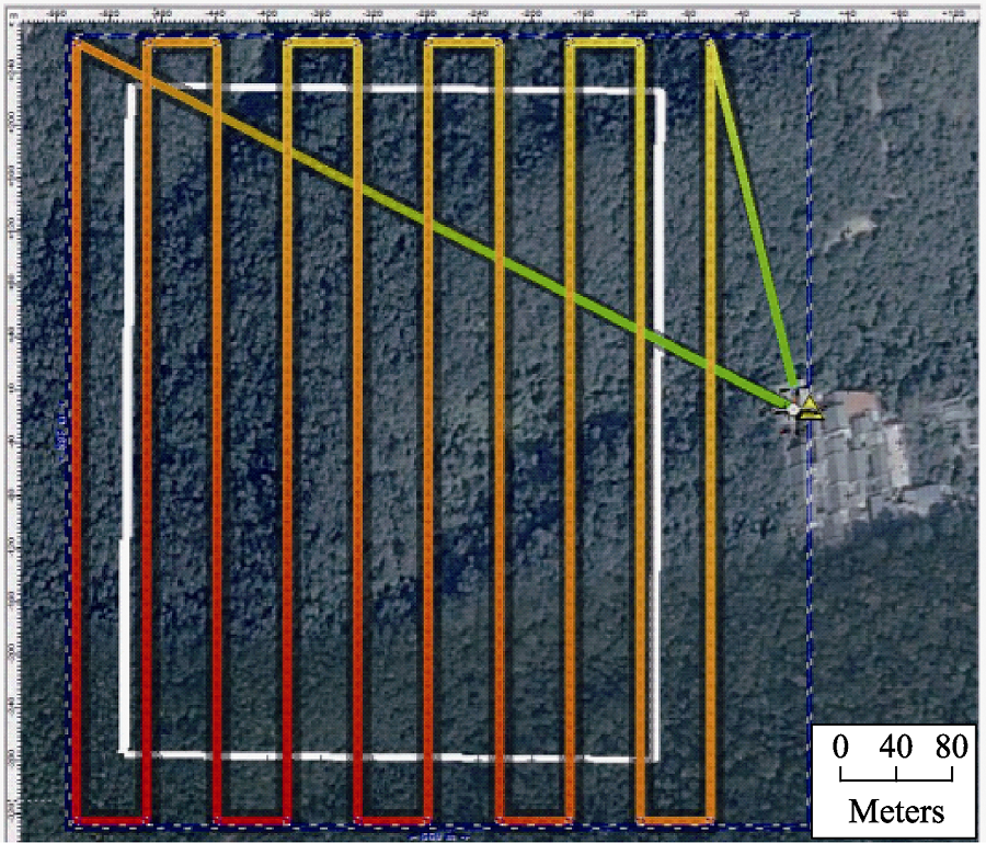
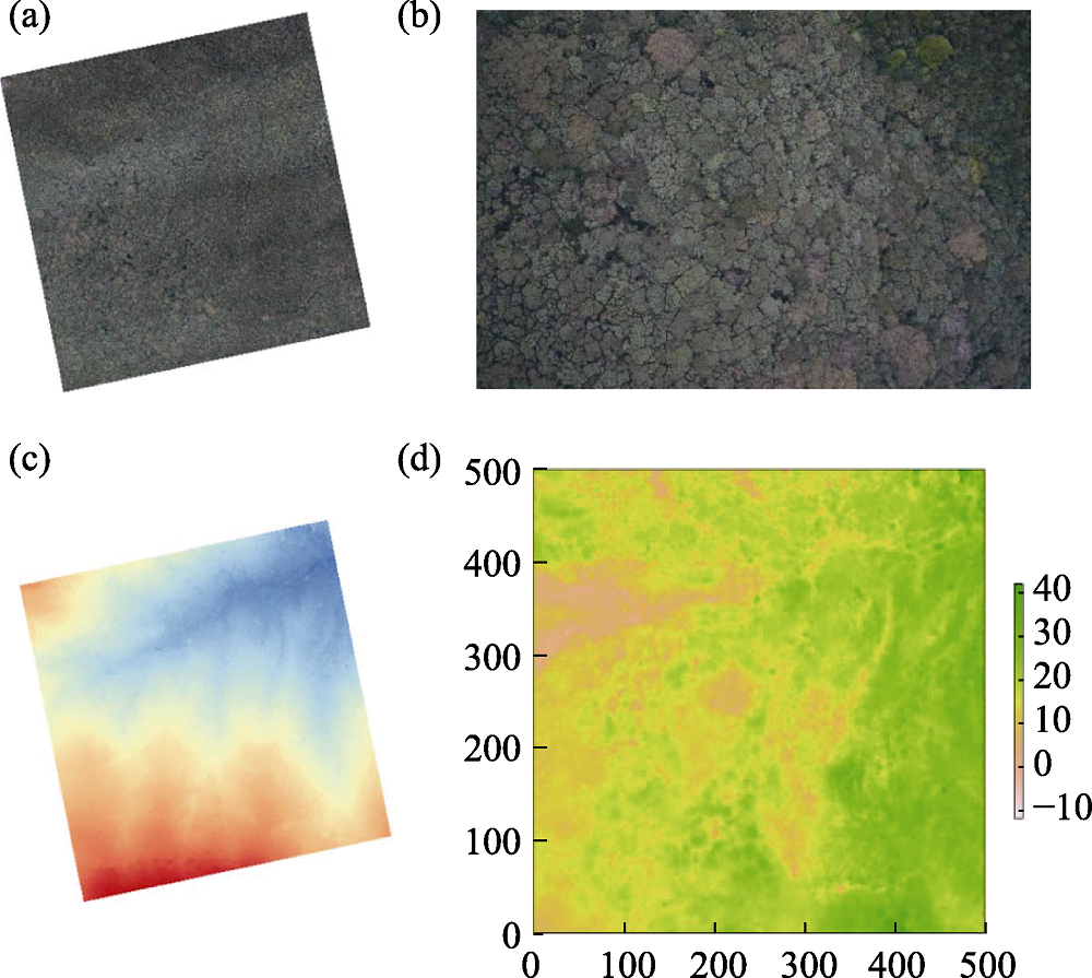
常绿阔叶林是我国亚热带地区的地带性植被类型。由于亚热带森林植物群落垂直结构复杂、林冠郁闭度高, 对常绿阔叶林冠层的研究尚缺乏高质量的监测数据。本数据集包含浙江天童山、浙江百山祖、广东车八岭、广东鼎湖山4个大于20 ha的森林动态监测样地2014年8月或2016年9月采集的无人机可见光遥感影像。本数据集是通过将无人机影像、地面控制点和地面调查数据相结合而获得的。每个样地的数据集包括4个文件: ~5 cm空间分辨率的正射影像图和数字表面模型、1 m空间分辨率的森林冠层高度数据和正射影像质量报告。本数据集可为常绿阔叶林的林冠生态学、生物多样性、生态系统功能等研究提供数据支撑。

关键词: 无人机遥感, 近地面遥感, 常绿阔叶林, 森林动态监测样地, 林冠生态学

Abstract

The evergreen broad-leaved forest is a zonal vegetation type in the subtropical regions of China. However, due to complex vertical structure and relatively dense canopy of subtropical forests, we are lack of reliable data in current canopy studies of this forest. Here we present a large dataset of visible light remote sensing images of four large-scale (> 20 ha) forest dynamic plots in Tiantongshan and Baishanzu of Zhejiang, and Dinghushan and Chebaling of Guangdong. These data were collected by unmanned aerial vehicle (UAV) equipped with visible light camera in August of 2014 or September of 2016. By combining the UAV data with ground survey data, we generated four data files for each plot: orthoimages and surface digital models with spatial resolution of ~5 cm, forest canopy height data with spatial resolution of 1 m, and data quality reports of the orthoimages. This dataset of evergreen broad-leaved forest provides significant supports for the studies in forest canopy ecology, biodiversity and ecosystem function.

Key words: UAV-based remote sensing, near-surface remote sensing, evergreen broad-leaved forest, forest dynamics plot, forest canopy ecology