
生物多样性 ›› 2019, Vol. 27 ›› Issue (1): 42-50. DOI: 10.17520/biods.2018249 cstr: 32101.14.biods.2018249
所属专题: 钱江源国家公园生物多样性保护与管理
李杰1,李巍岳1,*( ),付晶1,高峻1,杨蕾2,何苇航1
收稿日期:2018-09-17
接受日期:2019-01-07
出版日期:2019-01-20
发布日期:2019-03-15
通讯作者:
李巍岳
基金资助:
Li Jie1,Li Weiyue1,*(),Fu Jing1,Gao Jun1,Yang Lei2,He Weihang1
Received:2018-09-17
Accepted:2019-01-07
Online:2019-01-20
Published:2019-03-15
Contact:
Li Weiyue
摘要:
边界划分是国家公园保护与管理的重要手段, 通常以行政区和自然地理边界为参考, 借助人工干预的方法进行划分, 而较少考虑当地生态系统的完整性以及人为干扰因素, 造成边界划分不合理、不清晰。本研究以钱江源国家公园体制试点区中横岭角和古田山访客中心2处干扰较大的典型区为例, 用无人机近低空遥感技术结合实地植被调查, 评估现有功能分区。结果表明, 横岭角和古田山访客中心功能分区修正面积分别为53,550 m 2和19,667 m 2, 分别占航拍研究区域面积的29.75%和16.39%。功能分区不合理划分的原因包括: (1)人为干扰较大的区域与自然地物较难分辨; (2)部分边界划分没有考虑生态系统的完整性, 将面积较小或完整性稍差的天然林划分为保护级别较低的区域。本研究采用航拍影像结合地面调查, 从保护当地生态系统完整性和减小人为干扰因素的角度出发, 为国家公园功能分区边界划分与细化提供一种合理可行的方法。
李杰, 李巍岳, 付晶, 高峻, 杨蕾, 何苇航 (2019) 基于近低空遥感技术的国家公园功能分区边界识别: 以钱江源国家公园体制试点区为例. 生物多样性, 27, 42-50. DOI: 10.17520/biods.2018249.
Li Jie, Li Weiyue, Fu Jing, Gao Jun, Yang Lei, He Weihang (2019) Using low-altitude UAV remote sensing to identify national park functional zoning boundary: A case study in Qianjiangyuan National Park pilot. Biodiversity Science, 27, 42-50. DOI: 10.17520/biods.2018249.
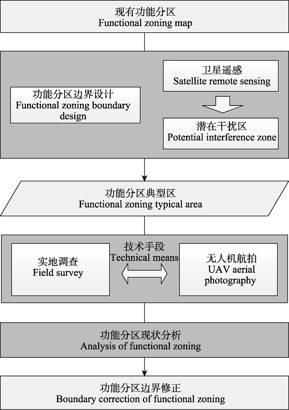
图1 研究总体思路
Fig. 1 Flowchart of study
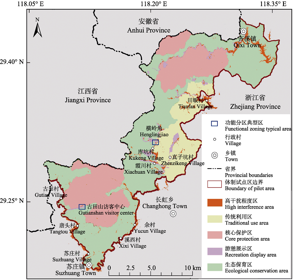
图2 钱江源国家公园干扰区分布图
Fig. 2 Interference distribution map of Qianjiangyuan National Park Pilot
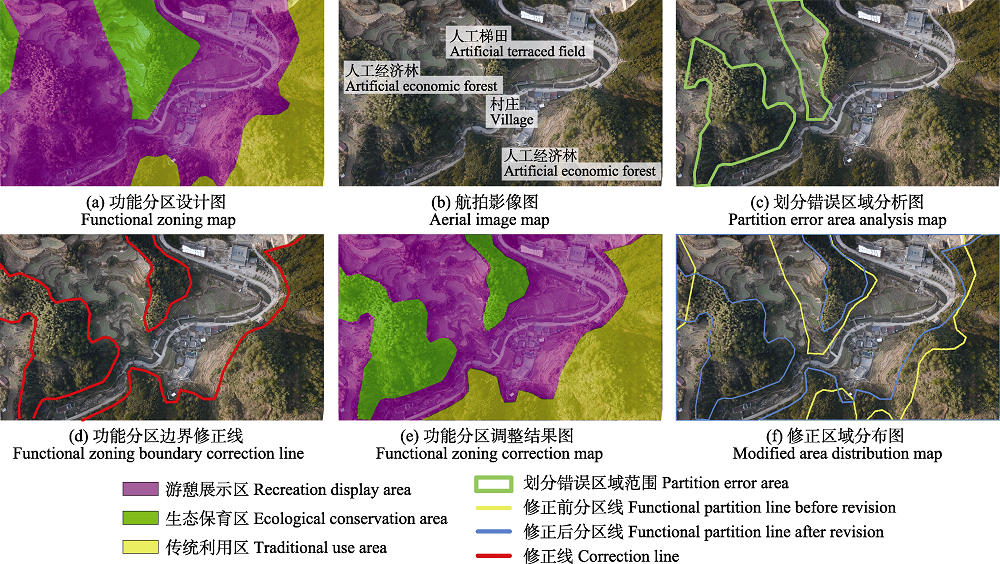
图3 库坑村横岭角航拍分析图
Fig. 3 Aerial image and analysis of Henglingjiao in Kukeng Village
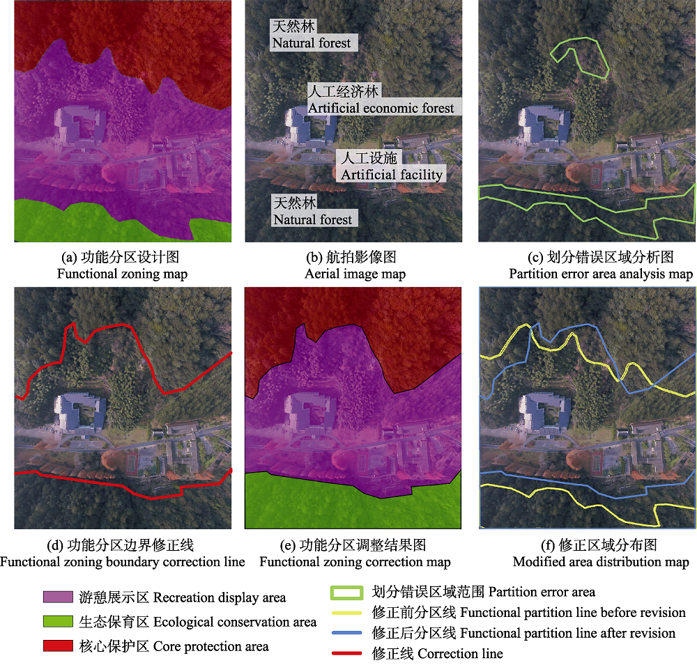
图4 古田山访客中心航拍分析图
Fig. 4 Aerial image and analysis of Gutianshan Visitor Center
| 修正前游憩展示区 Recreation display area before revision | 修正前生态保育区 Ecological conserveation area before revision | 修正前传统利用区 Traditional use area before revision | 修正前分区总计 Total original functional partition | |
|---|---|---|---|---|
| 修正后游憩展示区 Recreation display area after revision | 82,778 | 24,263 | 14,743 | 121,784 |
| 修正后生态保育区 Ecological conservation area after revision | 13,866 | 33,448 | - | 47,314 |
| 修正后传统利用区 Traditional use area after revision | 678 | - | 10,223 | 10,902 |
| 修正后分区总计 Total corrected functional partition | 97,322 | 57,711 | 24,967 | 180,000 |
表1 横岭角功能分区修正面积(m2)混淆矩阵
Table 1 Confusion matrix of function partition in Henglingjiao (m2)
| 修正前游憩展示区 Recreation display area before revision | 修正前生态保育区 Ecological conserveation area before revision | 修正前传统利用区 Traditional use area before revision | 修正前分区总计 Total original functional partition | |
|---|---|---|---|---|
| 修正后游憩展示区 Recreation display area after revision | 82,778 | 24,263 | 14,743 | 121,784 |
| 修正后生态保育区 Ecological conservation area after revision | 13,866 | 33,448 | - | 47,314 |
| 修正后传统利用区 Traditional use area after revision | 678 | - | 10,223 | 10,902 |
| 修正后分区总计 Total corrected functional partition | 97,322 | 57,711 | 24,967 | 180,000 |
| 修正前游憩展示区 Recreation display area before revision | 修正前生态保育区 Ecological conserveation area before revision | 修正前核心保护区 Core protection area before revision | 修正前分区总计 Total original functional partition | |
|---|---|---|---|---|
| 修正后游憩展示区 Recreation display area after revision | 56,168 | 9,139 | 4,541 | 69,848 |
| 修正后生态保育区 Ecological conservation area after revision | - | 12,502 | - | 12,502 |
| 修正后核心保护区 Core protection area after revision | 5,987 | - | 31,662 | 37,650 |
| 修正后分区总计 Total corrected functional partition | 62,155 | 21,641 | 36,204 | 120,000 |
表2 古田山访客中心功能分区修正面积(m2)混淆矩阵
Table 2 Confusion matrix of function partition in Gutianshan visitor center (m2)
| 修正前游憩展示区 Recreation display area before revision | 修正前生态保育区 Ecological conserveation area before revision | 修正前核心保护区 Core protection area before revision | 修正前分区总计 Total original functional partition | |
|---|---|---|---|---|
| 修正后游憩展示区 Recreation display area after revision | 56,168 | 9,139 | 4,541 | 69,848 |
| 修正后生态保育区 Ecological conservation area after revision | - | 12,502 | - | 12,502 |
| 修正后核心保护区 Core protection area after revision | 5,987 | - | 31,662 | 37,650 |
| 修正后分区总计 Total corrected functional partition | 62,155 | 21,641 | 36,204 | 120,000 |
| [4] |
[ 郭庆华, 吴芳芳, 胡天宇, 陈琳海, 刘瑾, 赵晓倩, 高上, 庞树鑫 ( 2016) 无人机在生物多样性遥感监测中的应用现状与展望. 生物多样性, 24, 1267-1278.]
DOI URL |
| [5] |
Huang LL, Zhu Q, Chen T ( 2007) Comparison of zoning models in protected natural areas overseas and its enlightenment. Tourism Tribune, 22(3), 18-25. (in Chinese with English abstract)
DOI URL |
|
[ 黄丽玲, 朱强, 陈田 ( 2007) 国外自然保护地分区模式比较及启示. 旅游学刊, 22(3), 18-25.]
DOI URL |
|
| [6] |
Huyan JQ, Xiao J, Yu BW, Xu WH ( 2014) Research progress in function zoning of nature reserves in China. Acta Ecologica Sinica, 34, 6391-6396. (in Chinese with English abstract)
DOI URL |
|
[ 呼延佼奇, 肖静, 于博威, 徐卫华 ( 2014) 我国自然保护区功能分区研究进展. 生态学报, 34, 6391-6396.]
DOI URL |
|
| [7] |
Liang JC, Ding ZF, Zhang CL, Hu HJ, Duo HR, Tang H ( 2017) Bird diversity spatial distribution patterns and hotspots in Maixiu Area of Sanjiangyuan National Nature Reserve, Qinghai Province. Biodiversity Science, 25, 294-303. (in Chinese with English abstract)
DOI URL |
|
[ 梁健超, 丁志锋, 张春兰, 胡慧建, 朵海瑞, 唐虹 ( 2017) 青海三江源国家级自然保护区麦秀分区鸟类多样性空间格局及热点区域研究. 生物多样性, 25, 294-303.]
DOI URL |
|
| [8] |
Lu B, He YH ( 2017) Species classification using unmanned aerial vehicle (UAV)-acquired high spatial resolution imagery in a heterogeneous grassland. ISPRS Journal of Photogrammetry and Remote Sensing, 128, 73-85.
DOI URL |
| [9] |
Puliti S, Ene LT, Gobakken T, N?sset E ( 2017) Use of partial-coverage UAV data in sampling for large scale forest inventories. Remote Sensing of Environment, 194, 115-126.
DOI URL |
| [10] |
Tang XP ( 2014) On the system of national parks and the path of development in China. Biodiversity Science, 22, 427-430. (in Chinese with English abstract)
DOI URL |
|
[ 唐小平 ( 2014) 中国国家公园体制及发展思路探析. 生物多样性, 22, 427-430.]
DOI URL |
|
| [11] |
Tang XP, Luan XF ( 2017) Developing a nature protected area system composed mainly of national parks. Forest Resources Management, ( 6), 1-8. (in Chinese with English abstract)
DOI URL |
|
[ 唐小平, 栾晓峰 ( 2017) 构建以国家公园为主体的自然保护地体系. 林业资源管理, ( 6), 1-8.]
DOI URL |
|
| [12] |
Tian JY, Wang L, Li XJ, Gong HL, Shi C, Zhong RF, Liu XM ( 2017) Comparison of UAV and WorldView-2 imagery for mapping leaf area index of mangrove forest. International Journal of Applied Earth Observation and Geoinformation, 61, 22-31.
DOI URL |
| [13] |
Wang J, Han ZJ, Peng PH, Chen WD, Chen YF ( 2012) Eco-sensitivity evaluation and functional zoning of Gongbu Nature Reserve in Tibet. Journal of Henan Normal University (Natural Science Edition), ( 6), 98-101. (in Chinese with English abstract)
DOI URL |
|
[ 王娟, 韩子钧, 彭培好, 陈文德, 陈颖峰 ( 2012) 工布自然保护区生态敏感性评价及功能区划. 河南师范大学学报(自然科学版), ( 6), 98-101.]
DOI URL |
|
| [14] | Wu CZ, Yang HN, Zhang YQ ( 2017) Behaviour analysis based function zoning model for national park in China—Taking Dashanbao National Park in Yunnan Province as an example. Environmental Protection, 45(14), 21-27. (in Chinese) |
| [ 吴承照, 杨浩楠, 张颖倩 ( 2017) 行为分析方法与国家公园功能分区模式——以云南大山包国家公园为例. 环境保护, 45(14), 21-27.] | |
| [15] |
Wu YL, Chen JP, Yao SP, Xu B ( 2017) Application of UAV low-altitude remote sensing. Remote Sensing for Land and Resources, 29(4), 120-125. (in Chinese with English abstract)
DOI URL |
|
[ 吴永亮, 陈建平, 姚书朋, 徐彬 ( 2017) 无人机低空遥感技术应用. 国土资源遥感, 29(4), 120-125.]
DOI URL |
|
| [1] |
Bai X, Ma KM, Yang L, Zhang JY, Zhang XL ( 2008) Ecological function differences inside and outside the wetland nature reserves in Sanjiang Plain. Acta Ecologica Sinica, 28, 620-626. (in Chinese with English abstract)
DOI URL |
|
[ 白雪, 马克明, 杨柳, 张洁瑜, 张小雷 ( 2008) 三江平原湿地保护区内外的生态功能差异. 生态学报, 28, 620-626.]
DOI URL |
|
| [16] | Yan GT, Shen H ( 2015) Study on planning system of national park series of China. Chinese Landscape Architecture, 31(2), 15-18. (in Chinese with English abstract) |
| [ 严国泰, 沈豪 ( 2015) 中国国家公园系列规划体系研究. 中国园林, 31(2), 15-18.] | |
| [2] |
Fu MD, Tian JL, Zhu YP, Tian Y, Zhao ZP, Li JS ( 2017) Identification of functional zones and methods of target management in Sanjiangyuan National Park. Biodiversity Science, 25, 71-79. (in Chinese with English abstract)
DOI URL |
|
[ 付梦娣, 田俊量, 朱彦鹏, 田瑜, 赵志平, 李俊生 ( 2017) 三江源国家公园功能分区与目标管理. 生物多样性, 25, 71-79.]
DOI URL |
|
| [17] |
Yang R, Cao Y ( 2017) How to promote the construction of national parks? Promoting scientific awareness and supporting scientific research. Man and the Biosphere, ( 4), 28-29. (in Chinese)
DOI URL |
|
[ 杨锐, 曹越 ( 2017) 怎样推进国家公园建设? 科学意识提升科学研究支撑. 人与生物圈, ( 4), 28-29.]
DOI URL |
|
| [3] | Guo QH, Hu TY, Jiang YX, Jin SC, Wang R, Guan HC, Yang QL, Li YM, Wu FF, Zhai QP, Liu J, Su YJ ( 2018) Advances in remote sensing application for biodiversity research. Biodiversity Science, 26, 789-806. (in Chinese with English abstract) |
| [ 郭庆华, 胡天宇, 姜媛茜, 金时超, 王瑞, 关宏灿, 杨秋丽, 李玉美, 吴芳芳, 翟秋萍, 刘瑾, 苏艳军 ( 2018) 遥感在生物多样性研究中的应用进展. 生物多样性, 26, 789-806.] | |
| [18] |
Yu H, Chen T, Zhong LS, Zhou R ( 2017) Functional zoning of the Qianjiangyuan National Park System Pilot Area. Resources Science, 39, 20-29. (in Chinese with English abstract)
DOI URL |
|
[ 虞虎, 陈田, 钟林生, 周睿 ( 2017) 钱江源国家公园体制试点区功能分区研究. 资源科学, 39, 20-29.]
DOI URL |
|
| [19] |
Zhang LB, Luo ZH, Mallon D, Li CW, Jiang ZG ( 2017) Biodiversity conservation status in China’s growing protected areas. Biological Conservation, 210, 89-100.
DOI URL |
| [20] |
Zhang LY, Ye WH, Huang ZL ( 2006) Assessment of function area design in Dinghushan Biosphere Reserve using landscape ecology principles. Biodiversity Science, 14, 98-106. (in Chinese with English abstract)
DOI URL |
| [4] |
Guo QH, Wu FF, Hu TY, Chen LH, Liu J, Zhao XQ, Gao S, Pang SX ( 2016) Perspectives and prospects of unmanned aerial vehicle in remote sensing monitoring of biodiversity. Biodiversity Science, 24, 1267-1278. (in Chinese with English abstract)
DOI URL |
| [20] |
[ 张林艳, 叶万辉, 黄忠良 ( 2006) 应用景观生态学原理评价鼎湖山自然保护区功能区划的实施与调整. 生物多样性, 14, 98-106.]
DOI URL |
| [1] | 李劲, 程铭昊, 张溢, 刘峰, 姜庆虎, 叶基荣, 陈展, 张于光. 不同海拔巴山冷杉林土壤微生物多样性及植物-微生物跨界生态网络关系[J]. 生物多样性, 2026, 34(4): 25276-. |
| [2] | 袁林溪, 王美震, 张利祥, 李彭, 张永生, 蒋学龙, 管振华. 人类活动对高黎贡白眉长臂猿栖息地乔木多样性及潜在食物资源的影响[J]. 生物多样性, 2026, 34(2): 25271-. |
| [3] | 孙啸宇. 中国国家公园人兽冲突解决的法治路径[J]. 生物多样性, 2026, 34(1): 25040-. |
| [4] | 柴恩平, 葛苏婷, 王锡茂, 杨州, 向昭宜, 张美惠, 李漫淑, 沈瑶, 斯幸峰. 基于高频监测研究人为干扰对城市夜鹭巢址分布动态及繁殖成功的影响[J]. 生物多样性, 2025, 33(9): 25025-. |
| [5] | 刘咏华, 童光蓉, 余航远, 王宁宁, 任海保, 陈磊, 马克平, 米湘成. 钱江源-百山祖国家公园候选区钱江源园区冠层三维结构及光谱特征对人为干扰的响应[J]. 生物多样性, 2025, 33(4): 24174-. |
| [6] | 田志奇, 苏杨. 环境相关国际公约的中国履约模式和在《生物多样性公约》中的应用: 从完成《昆蒙框架》目标和发挥国家公园作用的角度[J]. 生物多样性, 2025, 33(3): 24593-. |
| [7] | 苏红巧, 余得光, 牟昆仑. 国家公园与国土空间规划和用途管制制度衔接路径探讨[J]. 生物多样性, 2025, 33(3): 24570-. |
| [8] | 廖之锴, 白皓天, 张修瀚, 余上, 凌嘉乐, 刘阳. 海南热带雨林国家公园常见鸟类鸣声数据集[J]. 生物多样性, 2025, 33(11): 25194-. |
| [9] | 张雨琦, 文君, 张引, 李晟之. 大熊猫国家公园全民公益性评价研究: 基于利益相关者感知视角[J]. 生物多样性, 2024, 32(9): 24240-. |
| [10] | 王巍伟, 米湘成, 王宁宁, 任海保, 唐治喜, 张主宁, 马克平, 陈磊. 2005-2020年浙江古田山24 ha亚热带常绿阔叶林动态监测样地植物多样性数据集[J]. 生物多样性, 2024, 32(12): 24417-. |
| [11] | 耿云, 寇一祎, 范新卓, 徐姝瑶, 丛丽, 张玉钧. 基于卡诺模型的大熊猫国家公园自然教育需求研究[J]. 生物多样性, 2024, 32(1): 23101-. |
| [12] | 杜宇晨, 刘蓓萌, 陈俊峰, 王浩, 谢屹. 基于结构方程模型的农户保护意愿影响因素分析: 以东北虎豹国家公园珲春片区为例[J]. 生物多样性, 2024, 32(1): 23155-. |
| [13] | 崔国发. 关于自然保护地整合优化工作中几个关键问题的讨论与建议[J]. 生物多样性, 2023, 31(9): 22447-. |
| [14] | 陈声文, 任海保, 童光蓉, 王宁宁, 蓝文超, 薛建华, 米湘成. 钱江源国家公园木本植物物种多样性空间分布格局[J]. 生物多样性, 2023, 31(7): 22587-. |
| [15] | 李世东. 中国和美国国家公园时空发展及驱动因素[J]. 生物多样性, 2023, 31(6): 23040-. |
| 阅读次数 | ||||||
|
全文 |
|
|||||
|
摘要 |
|
|||||
备案号:京ICP备16067583号-7
Copyright © 2026 版权所有 《生物多样性》编辑部
地址: 北京香山南辛村20号, 邮编:100093
电话: 010-62836137, 62836665 E-mail: biodiversity@ibcas.ac.cn
![]()