
Biodiv Sci ›› 2025, Vol. 33 ›› Issue (3): 24526. DOI: 10.17520/biods.2024526 cstr: 32101.14.biods.2024526
• Special Feature: How the Kunming-Montreal Global Biodiversity Framework Becomes a Mainstream Work Objective in the China’s System • Previous Articles Next Articles
Wu Hui1( ), Yu Le1,2,*()(
 ), Du Zhenrong3(), Zhao Qiang1(), Qi Wenchao1(), Cao Yue4(), Wang Jinzhou5(), Shen Xiaoli6(), Sun Yao7, Ma Keping6,8()
Received:2024-12-01
Accepted:2025-03-04
Online:2025-03-20
Published:2025-03-04
Contact:
*E-mail: leyu@tsinghua.edu.cn
Supported by:Wu Hui, Yu Le, Du Zhenrong, Zhao Qiang, Qi Wenchao, Cao Yue, Wang Jinzhou, Shen Xiaoli, Sun Yao, Ma Keping. Rapid assessment of the Kunming-Montreal Global Biodiversity Framework implementation progress based on remote sensing monitoring: Pathway and prospects[J]. Biodiv Sci, 2025, 33(3): 24526.
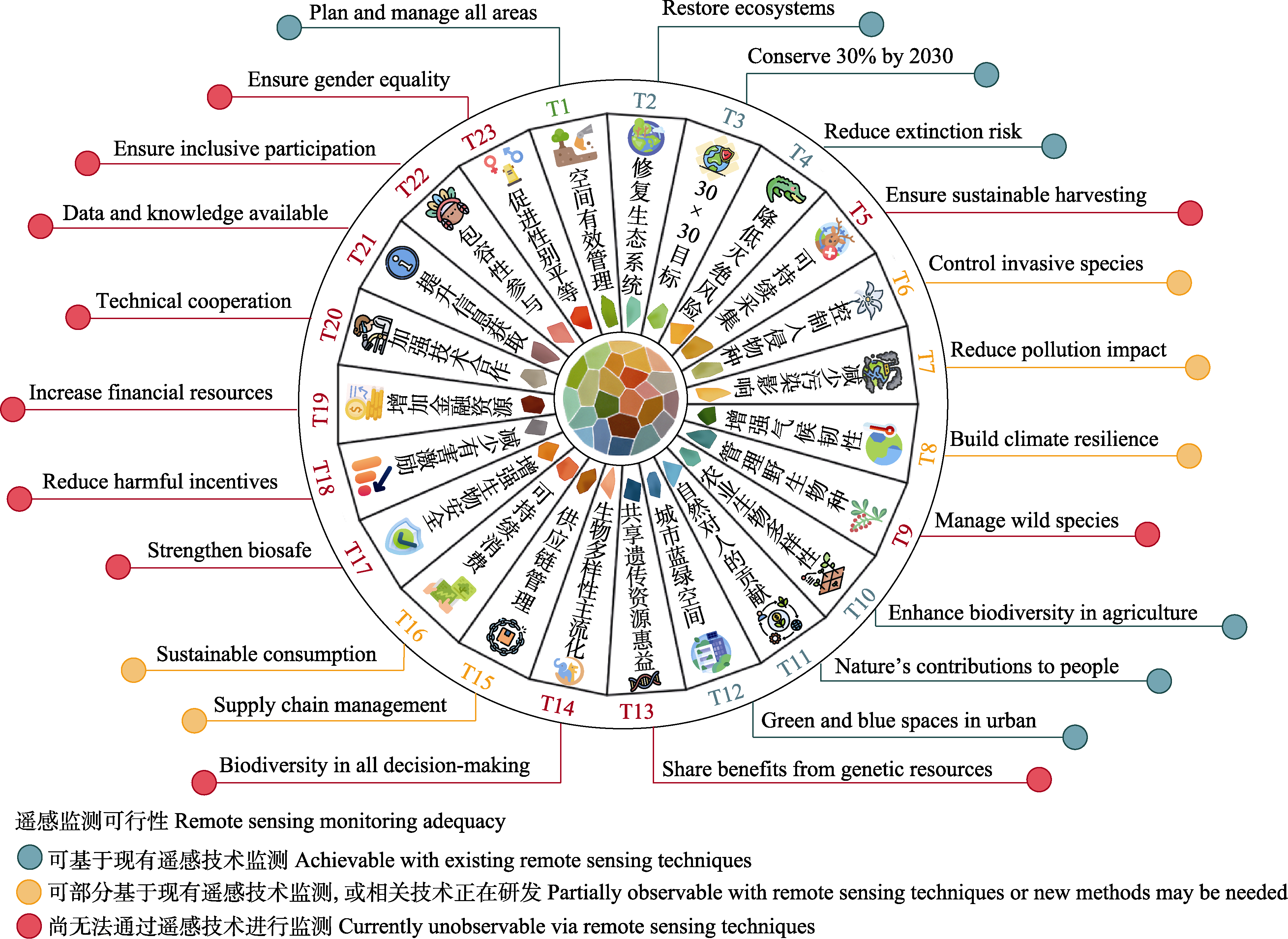
Fig. 1 Action targets of the Kunming-Montreal Global Biodiversity Framework and their adequacy for remote sensing monitoring

Fig. 2 Evaluation process of the implementation progress of the Kunming-Montreal Global Biodiversity Framework (KMGBF) based on remote sensing monitoring. LiDAR, Light detection and ranging; SAR, Synthetic aperture radar; UAV, Unmanned aerial vehicles; NBSAPs, National Biodiversity Strategies and Action Plans; NRs, National reports; RS-EBVs, Remote sensing-based essential biodiversity variables.

Fig. 3 Relationship between remote sensing-based essential biodiversity variables (RS-EBVs) and the targets of the Kunming-Montreal Global Biodiversity Framework (KMGBF)

Fig. 4 Workflow of the Chat KMGBF intelligent agent for the Kunming Montreal Global Biodiversity Framework (KMGBF). COT, Chain-of-thought; TOT, Tree of thought; NRs, National Reports; NBSAPs, National Biodiversity Strategies and Action Plans; RS-EBVs, Remote sensing-based essential biodiversity variables; API, Application programming interface; LoRA: Low-rank adaptation; RAG: Retrieval-augmented generation.
| [1] | Affinito F, Williams JM, Campbell JE, Londono MC, Gonzalez A(2024) Progress in developing and operationalizing the monitoring framework of the global biodiversity framework. Nature Ecology & Evolution, 8, 2163-2171. |
| [2] | Aguirre-Gutiérrez J, Berenguer E, Menor IO, Bauman D, Corral-Rivas JJ, Nava-Miranda MG, Both S, Ndong JE, Ondo FE, Bengone NN, Mihinhou V, Dalling JW, Heineman K, Figueiredo A, González-M R, Norden N, Hurtado-M AB, González D, Salgado-Negret B, Reis SM, Farfan-Rios W, Shenkin A, Riutta T, Girardin CAJ, Moore S, Abernethy K, Asner GP, Bentley LP, Burslem DFRP, Cernusak LA, Enquist BJ, Ewers RM, Ferreira J, Jeffery KJ, Joly CA, Marimon-Junior BH, Martin RE, Morandi PS, Phillips OL, Bennett AC, Lewis SL, Quesada CA, Marimon BS, Kissling WD, Silman M, Teh YA, White LJT, Salinas N, Coomes DA, Barlow J, Adu-Bredu S, Malhi Y(2022) Functional susceptibility of tropical forests to climate change. Nature Ecology & Evolution, 6, 878-889. |
| [3] | Alleaume S, Dusseux P, Thierion V, Commagnac L, Laventure S, Lang M, Féret JB, Hubert-Moy L, Luque S(2018) A generic remote sensing approach to derive operational essential biodiversity variables (EBVs) for conservation planning. Methods in Ecology & Evolution, 9, 1822-1836. |
| [4] | Aubert G, Dudley N(2023) Progress on implementing the Kunming-Montreal Global Biodiversity Framework. (accessed on 2025-03-01) https://ieep.eu/wp-content/uploads/2024/01/Progress-on-implementing-the-KunmingMontreal-Global-Biodiversity-FrameworkIEEP-2023.pdf. |
| [5] |
Brennan A, Naidoo R, Greenstreet L, Mehrabi Z, Ramankutty N, Kremen C(2022) Functional connectivity of the world’s protected areas. Science, 376, 1101-1104.
DOI PMID |
| [6] | Brooks TM, Pimm SL, Akçakaya HR, Buchanan GM, Butchart SHM, Foden W, Hilton-Taylor C, Hoffmann M, Jenkins CN, Joppa L, Li BV, Menon V, Ocampo-Peñuela N, Rondinini C(2019) Measuring terrestrial area of habitat (AOH) and its utility for the IUCN Red List. Trends in Ecology & Evolution, 34, 977-986. |
| [7] | Brown T, Mann B, Ryder N, Subbiah M, Kaplan JD, Dhariwal P, Neelakantan A, Shyam P, Sastry G, Askell A, Agarwal S, Herbert-Voss A, Krueger G, Henighan T, Child R, Ramesh A, Ziegler D, Wu J, Winter C, Hesse C, Chen M, Sigler E, Litwin M, Gray S, Chess B, Clark J, Berner C, McCandlish S, Radford A, Sutskever I, Amodei D(2020) Language models are few-shot learners. Advances in Neural Information Processing Systems, 33, 1877-1901. |
| [8] | Burgess ND, Ali N, Bedford J, Bhola N, Brooks S, Cierna A, Correa R, Harris M, Hargey A, Hughes J, McDermott-Long O, Miles L, Ravilious C, Rodrigues AR, van Soesbergen A, Sihvonen H, Seager A, Swindell L, Vukelic M, Paz Durán A, Green JMH, West C, Weatherdon LV, Hawkins F, Brooks TM, Kingston N, Butchart SHM(2024) Global metrics for terrestrial biodiversity. Annual Review of Environment and Resources, 49, 673-709. |
| [9] | Callaghan CT, Borda-de-Água L, van Klink R, Rozzi R, Pereira HM(2023) Unveiling global species abundance distributions. Nature Ecology & Evolution, 7, 1600-1609. |
| [10] | Cardinale BJ, Duffy JE, Gonzalez A, Hooper DU, Perrings C, Venail P, Narwani A, Mace GM, Tilman D, Wardle DA, Kinzig AP, Daily GC, Loreau M, Grace JB, Larigauderie A, Srivastava DS, Naeem S(2012) Biodiversity loss and its impact on humanity. Nature, 486, 59-67. |
| [11] | CBD (Convention on Biological Diversity) (2022a) Kunming-Montreal Global Biodiversity Framework. (accessed on 2025-03-01) https://www.cbd.int/doc/decisions/cop-15/cop-15-dec-04-en.pdf/. |
| [12] | CBD (Convention on Biological Diversity) (2022b) Monitoring Framework for the Kunming-Montreal Global Biodiversity Framework. (accessed on 2025-03-01) https://www.cbd.int/doc/decisions/cop-15/cop-15-dec-05-en.pdf/. |
| [13] | CBD (Convention on Biological Diversity) (2022c) Mechanisms for Planning, Monitoring, Reporting and Review. (accessed on 2025-03-01) https://www.cbd.int/doc/decisions/cop-15/cop-15-dec-06-en.pdf/. |
| [14] | CBD (Convention on Biological Diversity) (2024) Mechanisms for Planning, Monitoring, Reporting and Review, Including the Global Review of Collective Progress in the Implementation of the Kunming-Montreal Global Biodiversity Framework to be Conducted at the Seventeenth and Nineteenth Meetings of the Conference of the Parties. (accessed on 2025-03-01) https://www.cbd.int/doc/c/aa9c/e8b6/0c916bc02c3033d992521bfb/cop-16-l-33-en.pdf/. |
| [15] | CBD (Convention on Biological Diversity) (2025) Monitoring Framework for the Kunming-Montreal Global Biodiversity Framework. (accessed on 2025-03-01) https://www.cbd.int/doc/c/1e13/f20d/81cd8447744640bbd21e008f/cop-16-l-26-rev1-en.pdf/. |
| [16] | Chaplin-Kramer R, Brauman KA, Cavender-Bares J, Díaz S, Duarte GT, Enquist BJ, Garibaldi LA, Geldmann J, Halpern BS, Hertel TW, Khoury CK, Krieger JM, Lavorel S, Mueller T, Neugarten RA, Pinto-Ledezma J, Polasky S, Purvis A, Reyes-García V, Roehrdanz PR, Shannon LJ, Shaw MR, Strassburg BBN, Tylianakis JM, Verburg PH, Visconti P, Zafra-Calvo N(2022) Conservation needs to integrate knowledge across scales. Nature Ecology & Evolution, 6, 118-119. |
| [17] |
Coops NC, Kearney SP, Bolton DK, Radeloff VC(2018) Remotely-sensed productivity clusters capture global biodiversity patterns. Scientific Reports, 8, 16261.
DOI PMID |
| [18] | Curd A, Chevalier M, Vasquez M, Boyé A, Firth LB, Marzloff MP, Bricheno LM, Burrows MT, Bush LE, Cordier C, Davies AJ, Green JAM, Hawkins SJ, Lima FP, Meneghesso C, Mieszkowska N, Seabra R, Dubois SF(2023) Applying landscape metrics to species distribution model predictions to characterize internal range structure and associated changes. Global Change Biology, 29, 631-647. |
| [19] | Díaz-Delgado R, Cazacu C, Adamescu M(2019) Rapid assessment of ecological integrity for LTER wetland sites by using UAV multispectral mapping. Drones, 3, 3. |
| [20] | Du ZR, Yu L, Arvor D, Li XY, Cao X, Zhong LH, Zhao Q, Ma XR, Wang HY, Liu XX, Zhang MJ, Xu B, Gong P(2024) Dual data- and knowledge-driven land cover mapping framework for monitoring annual and near-real-time changes. IEEE Transactions on Geoscience and Remote Sensing, 62, 4411314. |
| [21] | Enquist BJ, Feng X, Boyle B, Maitner B, Newman EA, Jørgensen PM, Roehrdanz PR, Thiers BM, Burger JR, Corlett RT, Couvreur TLP, Dauby G, Donoghue JC, Foden W, Lovett JC, Marquet PA, Merow C, Midgley G, Morueta-Holme N, Neves DM, Oliveira-Filho AT, Kraft NJB, Park DS, Peet RK, Pillet M, Serra-Diaz JM, Sandel B, Schildhauer M, Šímová I, Violle C, Wieringa JJ, Wiser SK, Hannah L, Svenning JC, McGill BJ(2019) The commonness of rarity: Global and future distribution of rarity across land plants. Science Advances, 5, eaaz0414. |
| [22] | Ford HV, Schrodt F, Zieritz A, Exton DA, van der Heijden G, Teague J, Coles T, Field R(2024) A technological biodiversity monitoring toolkit for biocredits. Journal of Applied Ecology, 61, 2007-2019. |
| [23] |
Goettsch B, Hilton-Taylor C, Cruz-Piñón G, Duffy JP, Frances A, Hernández HM, Inger R, Pollock C, Schipper J, Superina M, Taylor NP, Tognelli M, Abba AM, Arias S, Arreola-Nava HJ, Baker MA, Bárcenas RT, Barrios D, Braun P, Butterworth CA, Búrquez A, Caceres F, Chazaro-Basañez M, Corral-Díaz R, del Valle Perea M, Demaio PH, Duarte de Barros WA, Durán R, Faúndez Yancas L, Felger RS, Fitz-Maurice B, Fitz-Maurice WA, Gann G, Gómez-Hinostrosa C, Gonzales-Torres LR, Griffith MP, Guerrero PC, Hammel B, Heil KD, Hernández-Oria JG, Hoffmann M, Ishiki Ishihara M, Kiesling R, Larocca J, León-de la Luz JL, Loaiza SCR, Lowry M, Machado MC, Majure LC, Martínez Ávalos JG, Martorell C, Maschinski J, Méndez E, Mittermeier RA, Nassar JM, Negrón-Ortiz V, Oakley LJ, Ortega-Baes P, Ferreira ABP, Pinkava DJ, Porter JM, Puente-Martinez R, Roque Gamarra J, Saldivia Pérez P, Sánchez Martínez E, Smith M, Sotomayor M del C JM, Stuart SN, Tapia Muñoz JL, Terrazas T, Terry M, Trevisson M, Valverde T, van Devender TR, Véliz-Pérez ME, Walter HE, Wyatt SA, Zappi D, Zavala-Hurtado JA, Gaston KJ(2015) High proportion of cactus species threatened with extinction. Nature Plants, 1, 15142.
DOI PMID |
| [24] |
Grantham HS, Duncan A, Evans TD, Jones KR, Beyer HL, Schuster R, Walston J, Ray JC, Robinson JG, Callow M, Clements T, Costa HM, DeGemmis A, Elsen PR, Ervin J, Franco P, Goldman E, Goetz S, Hansen A, Hofsvang E, Jantz P, Jupiter S, Kang A, Langhammer P, Laurance WF, Lieberman S, Linkie M, Malhi Y, Maxwell S, Mendez M, Mittermeier R, Murray NJ, Possingham H, Radachowsky J, Saatchi S, Samper C, Silverman J, Shapiro A, Strassburg B, Stevens T, Stokes E, Taylor R, Tear T, Tizard R, Venter O, Visconti P, Wang S, Watson JEM(2020) Anthropogenic modification of forests means only 40% of remaining forests have high ecosystem integrity. Nature Communications, 11, 5978.
DOI PMID |
| [25] | Hansen MC, Loveland TR(2012) A review of large area monitoring of land cover change using Landsat data. Remote Sensing of Environment, 122, 66-74. |
| [26] | Hughes AC(2023a) Developing biodiversity baselines to develop and implement future conservation targets. Plants, 12, 2291. |
| [27] | Hughes AC(2023b) The Post- 2020 Global Biodiversity Framework: How did we get here, and where do we go next? Integrative Conservation, 2, 1-9. |
| [28] | Illarionova S, Trekin A, Ignatiev V, Oseledets I(2021) Neural-based hierarchical approach for detailed dominant forest species classification by multispectral satellite imagery. IEEE Journal of Selected Topics in Applied Earth Observations and Remote Sensing, 14, 1810-1820. |
| [29] | IPBES (Intergovernmental Science-Policy Platform for Biodiversity and Ecosystem Services) (2019) Summary for Policymakers of the Global Assessment Report on Biodiversity and Ecosystem Services of the Intergovernmental Science-Policy Platform on Biodiversity and Ecosystem Services. IPBES Secretariat, Bonn, Germany. |
| [30] | Jetz W, McGeoch MA, Guralnick R, Ferrier S, Beck J, Costello MJ, Fernandez M, Geller GN, Keil P, Merow C, Meyer C, Muller-Karger FE, Pereira HM, Regan EC, Schmeller DS, Turak E(2019) Essential biodiversity variables for mapping and monitoring species populations. Nature Ecology & Evolution, 3, 539-551. |
| [31] | Keith DA, Ferrer-Paris JR, Nicholson E, Bishop MJ, Polidoro BA, Ramirez-Llodra E, Tozer MG, Nel JL, Mac Nally R, Gregr EJ, Watermeyer KE, Essl F, Faber-Langendoen D, Franklin J, Lehmann CER, Etter A, Roux DJ, Stark JS, Rowland JA, Brummitt NA, Fernandez-Arcaya UC, Suthers IM, Wiser SK, Donohue I, Jackson LJ, Pennington RT, Iliffe TM, Gerovasileiou V, Giller P, Robson BJ, Pettorelli N, Andrade A, Lindgaard A, Tahvanainen T, Terauds A, Chadwick MA, Murray NJ, Moat J, Pliscoff P, Zager I, Kingsford RT(2022) A function-based typology for Earth’s ecosystems. Nature, 610, 513-518. |
| [32] | Keith DA, Ferrer-Paris JR, Nicholson E, Kingsford RT(2020) The IUCN Global Ecosystem Typology 2.0: Descriptive Profiles for Biomes and Ecosystem Functional Groups. (accessed on 2025-03-01) https://portals.iucn.org/library/sites/library/files/documents/2020-037-En.pdf/. |
| [33] | Kissling WD, Ahumada JA, Bowser A, Fernandez M, Fernández N, García EA, Guralnick RP, Isaac NJB, Kelling S, Los W, McRae L, Mihoub JB, Obst M, Santamaria M, Skidmore AK, Williams KJ, Agosti D, Amariles D, Arvanitidis C, Bastin L, De Leo F, Egloff W, Elith J, Hobern D, Martin D, Pereira HM, Pesole G, Peterseil J, Saarenmaa H, Schigel D, Schmeller DS, Segata N, Turak E, Uhlir PF, Wee B, Hardisty AR(2018) Building essential biodiversity variables (EBVs) of species distribution and abundance at a global scale. Biological Reviews, 93, 600-625. |
| [34] | Kuenzer C, Ottinger M, Wegmann M, Guo HD, Wang CL, Zhang JZ, Dech S, Wikelski M(2014) Earth observation satellite sensors for biodiversity monitoring: Potentials and bottlenecks. International Journal of Remote Sensing, 35, 6599-6647. |
| [35] | Lee J, Yoon W, Kim S, Kim D, Kim S, So CH, Kang J(2020) BioBERT: A pre-trained biomedical language representation model for biomedical text mining. Bioinformatics, 36, 1234-1240. |
| [36] |
Lumbierres M, Dahal PR, Soria CD, Di Marco M, Butchart SHM, Donald PF, Rondinini C(2022) Area of habitat maps for the world’s terrestrial birds and mammals. Scientific Data, 9, 749.
DOI PMID |
| [37] |
Ma KP(2023) Kunming-Montreal Global Biodiversity Framework: An important global agenda for biodiversity conservation. Biodiversity Science, 31, 23133. (in Chinese)
DOI |
|
[ 马克平 (2023) 《昆明-蒙特利尔全球生物多样性框架》是重要的全球生物多样性保护议程. 生物多样性, 31, 23133.]
DOI |
|
| [38] | Ma KP, Shen XL, Grumbine RE, Corlett R(2017) China’s biodiversity conservation research in progress. Biological Conservation, 210, 1-2. |
| [39] | Mammola S, Carmona CP, Guillerme T, Cardoso P(2021) Concepts and applications in functional diversity. Functional Ecology, 35, 1869-1885. |
| [40] |
Maney C, Guaras D, Harrison J, Guizar-Coutiño A, Harfoot MBJ, Hill SLL, Burgess ND, Sutherland W(2024) National commitments to Aichi Targets and their implications for monitoring the Kunming-Montreal Global Biodiversity Framework. npj Biodiversity, 3, 6.
DOI PMID |
| [41] | Mayr S, Kuenzer C, Gessner U, Klein I, Rutzinger M(2019) Validation of earth observation time-series: A review for large-area and temporally dense land surface products. Remote Sensing, 11, e2616. |
| [42] | O’Connor B, Secades C, Penner J, Sonnenschein R, Skidmore A, Burgess ND, Hutton JM(2015) Earth observation as a tool for tracking progress towards the Aichi Biodiversity Targets. Remote Sensing in Ecology and Conservation, 1, 19-28. |
| [43] | Paganini M, Leidner AK, Geller G, Turner W, Wegmann M(2016) The role of space agencies in remotely sensed essential biodiversity variables. Remote Sensing in Ecology and Conservation, 2, 132-140. |
| [44] |
Pereira HM, Ferrier S, Walters M, Geller GN, Jongman RHG, Scholes RJ, Bruford MW, Brummitt N, Butchart SHM, Cardoso AC, Coops NC, Dulloo E, Faith DP, Freyhof J, Gregory RD, Heip C, Höft R, Hurtt G, Jetz W, Karp DS, McGeoch MA, Obura D, Onoda Y, Pettorelli N, Reyers B, Sayre R, Scharlemann JPW, Stuart SN, Turak E, Walpole M, Wegmann M(2013) Essential biodiversity variables. Science, 339, 277-278.
DOI PMID |
| [45] | Petrou ZI, Manakos I, Stathaki T(2015) Remote sensing for biodiversity monitoring: A review of methods for biodiversity indicator extraction and assessment of progress towards international targets. Biodiversity and Conservation, 24, 2333-2363. |
| [46] | Pettorelli N, Laurance WF, O’Brien TG, Wegmann M, Nagendra H, Turner W(2014) Satellite remote sensing for applied ecologists: Opportunities and challenges. Journal of Applied Ecology, 51, 839-848. |
| [47] | Potapov P, Hansen MC, Laestadius L, Turubanova S, Yaroshenko A, Thies C, Smith W, Zhuravleva I, Komarova A, Minnemeyer S, Esipova E(2017) The last frontiers of wilderness: Tracking loss of intact forest landscapes from 2000 to 2013. Science Advances, 3, e1600821. |
| [48] | Randin CF, Ashcroft MB, Bolliger J, Cavender-Bares J, Coops NC, Dullinger S, Dirnböck T, Eckert S, Ellis E, Fernández N, Giuliani G, Guisan A, Jetz W, Joost S, Karger D, Lembrechts J, Lenoir J, Luoto M, Morin X, Price B, Rocchini D, Schaepman M, Schmid B, Verburg P, Wilson A, Woodcock P, Yoccoz N, Payne D(2020) Monitoring biodiversity in the Anthropocene using remote sensing in species distribution models. Remote Sensing of Environment, 239, 111626. |
| [49] |
Ren Y, Tao SL, Hu TY, Yang HT, Guan HC, Su YJ, Cheng K, Chen MX, Wan HW, Guo QH(2022) The outlook and system construction for monitoring Essential Biodiversity Variables based on remote sensing: The case of China. Biodiversity Science, 30, 22530. (in Chinese with English abstract)
DOI |
|
[ 任淯, 陶胜利, 胡天宇, 杨海涛, 关宏灿, 苏艳军, 程凯, 陈梦玺, 万华伟, 郭庆华 (2022) 中国生物多样性核心监测指标遥感产品体系构建与思考. 生物多样性, 30, 22530.]
DOI |
|
| [50] | Schmeller DS, Mihoub JB, Bowser A, Arvanitidis C, Costello MJ, Fernandez M, Geller GN, Hobern D, Kissling WD, Regan E, Saarenmaa H, Turak E, Isaac NJB(2017) An operational definition of essential biodiversity variables. Biodiversity and Conservation, 26, 2967-2972. |
| [51] | Secades C, O’Connor B, Brown C, Walpole M(2014) Earth Observation for Biodiversity Monitoring: A Review of Current Approaches and Future Opportunities for Tracking Progress towards the Aichi Biodiversity Targets. Secretariat of the Convention on Biological Diversity, Montréal, Canada. |
| [52] | Shokirov S, Jucker T, Levick SR, Manning AD, Bonnet T, Yebra M, Youngentob KN(2023) Habitat highs and lows: Using terrestrial and UAV LiDAR for modelling avian species richness and abundance in a restored woodland. Remote Sensing of Environment, 285, 113326. |
| [53] | Skidmore AK, Coops NC, Neinavaz E, Ali A, Schaepman ME, Paganini M, Kissling WD, Vihervaara P, Darvishzadeh R, Feilhauer H, Fernandez M, Fernández N, Gorelick N, Geijzendorffer I, Heiden U, Heurich M, Hobern D, Holzwarth S, Muller-Karger FE, Van De Kerchove R, Lausch A, Leitão PJ, Lock MC, Mücher CA, O’Connor B, Rocchini D, Roeoesli C, Turner W, Vis JK, Wang TJ, Wegmann M, Wingate V(2021) Priority list of biodiversity metrics to observe from space. Nature Ecology & Evolution, 5, 896-906. |
| [54] | Timmermans J, Kissling WD(2023) Advancing terrestrial biodiversity monitoring with satellite remote sensing in the context of the Kunming-Montreal Global Biodiversity Framework. Ecological Indicators, 154, 110773. |
| [55] | Wan FM, Wan HW, Zhang ZR, Gao JX, Sun CX, Wang YC(2024) The application potential of unmanned aerial vehicle surveys in grassland plant diversity. Biodiversity Science, 32, 23381. (in Chinese with English abstract) |
|
[ 万凤鸣, 万华伟, 张志如, 高吉喜, 孙晨曦, 王永财 (2024) 草地植物多样性无人机调查的应用潜力. 生物多样性, 32, 23381.]
DOI |
|
| [56] | Wang R, Gamon JA(2019) Remote sensing of terrestrial plant biodiversity. Remote Sensing of Environment, 231, 111218. |
| [57] |
Wei FW, Costanza R, Dai Q, Stoeckl N, Gu X, Farber S, Nie Y, Kubiszewski I, Hu Y, Swaisgood R, Yang X, Bruford M, Chen Y, Voinov A, Qi D, Owen M, Yan L, Kenny DC, Zhang Z, Hou R, Jiang S, Liu H, Zhan X, Zhang L, Yang B, Zhao L, Zheng X, Zhou W, Wen Y, Gao H, Zhang W(2018) The value of ecosystem services from giant panda reserves. Current Biology, 28, 2174-2180.
DOI PMID |
| [58] | Wei FW, Wu Q, Hu YB, Huang GP, Nie YG, Yan L(2019) Conservation metagenomics: A new branch of conservation biology. Science China: Life Sciences, 62, 168-178. |
| [59] |
Wu ZJ, Zhang C, Gu XW, Duporge I, Hughey LF, Stabach JA, Skidmore AK, Hopcraft JGC, Lee SJ, Atkinson PM, McCauley DJ, Lamprey R, Ngene S, Wang T(2023) Deep learning enables satellite-based monitoring of large populations of terrestrial mammals across heterogeneous landscape. Nature Communications, 14, 3072.
DOI PMID |
| [60] | WWF (World Wide Fund for Nature) (2024) Living Planet Report 2024—A System in Peril. WWF, Gland, Switzerland. |
| [61] |
Xu J, Wang JZ(2023) Analysis of the main elements and implications of the Kunming-Montreal Global Biodiversity Framework. Biodiversity Science, 31, 23020. (in Chinese with English abstract)
DOI |
|
[ 徐靖, 王金洲 (2023) 《昆明-蒙特利尔全球生物多样性框架》主要内容及其影响. 生物多样性, 31, 23020.]
DOI |
|
| [62] | Yu L, Du ZR, Dong R, Zheng J, Tu Y, Chen X, Hao P, Zhong B, Peng D, Zhao J, Li X, Yang J, Fu H, Yang G, Gong P(2022) FROM-GLC Plus: Toward near real-time and multi-resolution land cover mapping. GIScience & Remote Sensing, 59, 1026-1047. |
| [63] | Yu L, Du ZR, Li X, Zhao Q, Wu H, Weise D, Yuan X, Yang Y, Cai W, Song W, Wang P, Zhao Z, Long Y, Zhang Y, Peng J, Xin X, Xu F, Shen M, Wang H, Jiao YM, Li TT, Sun ZT, Zhao YG, Fang MY, Peng DL, Wu CY, Li S, Shen XL, Ma KP, Lin GH, Luo Y(2024) Near surface camera informed agricultural land monitoring for climate smart agriculture. Climate Smart Agriculture, 1, 100008. |
| [64] | Yu L, Du ZR, Li X, Zheng J, Zhao Q, Wu H, Weise D, Yang Y, Zhang Q, Li X, Ma X, Huang X(2025) Enhancing global agricultural monitoring system for climate-smart agriculture. Climate Smart Agriculture, 2, 100037. |
| [1] | Lijie Zhou, Minhui Huang, Huaijiang He, Yanxia Cheng, Chunyu Zhang, Xiuhai Zhao. Disentangling the patterns, components, and influencing factors of forest β diversity in the Xiaoxing’an Mountains, Northeast China [J]. Biodiv Sci, 2026, 34(4): 25443-. |
| [2] | Yunyue Peng, Kui Peng, Xinran Liu, Tianyi Sun, Xiaoquan Zhang. Corporate engagement pathways, market development barriers and recommendations for biodiversity credits [J]. Biodiv Sci, 2026, 34(4): 26031-. |
| [3] | Boyao Li, Tiancheng Sheng, Xiaoyun Xing. Impact of biodiversity risk on corporate financial performance: Evidence from listed companies in China [J]. Biodiv Sci, 2026, 34(4): 25330-. |
| [4] | Hao Liu, Yuxiao Zhang, Bing Liu, Feifei Li, Hongzheng Ma, Haining Qin, Dezhu Li, Wenli Chen. Diversity and checklist of grasses (Poaceae) in China [J]. Biodiv Sci, 2026, 34(4): 25438-. |
| [5] | Ziyi Kong, Degang Wang, Jiantao Wang, Zhiyong Pei, Jing Sun, Changchun Zhang, Junguo Zhang. Wildlife pose estimation based on the SCD-HRNet model and its application in biodiversity monitoring: A case study of the Saihanwula Region, Inner Mongolia [J]. Biodiv Sci, 2026, 34(4): 25287-. |
| [6] | Haoyou Zhu, Youbing Zhou, Yi Luo, Zhaomin Zhou. Changes in breeding bird community in an urban area of Nanchong over two decades [J]. Biodiv Sci, 2026, 34(3): 24560-. |
| [7] | Shuyu Hou, Yingying Liu, Rui Yang. Progress of international OECMs practices under the Kunming-Montreal Global Biodiversity Framework and pathways for localization in China [J]. Biodiv Sci, 2026, 34(3): 25264-. |
| [8] | Xiaofan Cheng, Qingyuan Li, Yuanhui Li, Mingxiang Zhang. The dilemmas and solutions for invasive alien species governance policy systems [J]. Biodiv Sci, 2026, 34(2): 25332-. |
| [9] | Lulu Chen, Haoting Tang, Hong Leng, Qing Yuan, Xinyue Yang. Impacts of urban block built environments on biodiversity—A review and outlook [J]. Biodiv Sci, 2026, 34(2): 25286-. |
| [10] | Wenqi Gao, Jingrong Xiang, Yao Zhao, Lingshuang Fan, Yuan Gu, Weihan Shao, Gaojun Li, Guangjun Zhao, Mingbin Chen, Xingwei Cai, Kai Chen. Stream fish community characteristics and their response to land use in Limushan and Jianfengling of Hainan Tropical Rainforest National Park [J]. Biodiv Sci, 2026, 34(2): 25374-. |
| [11] | Xiaoqiang Lu, Dan Rui, Jiangfeng Zhang, Bingxin Yin, Yulu Wang, Yuting Cen, Yichen Cui, Wanxia Yang. Impacts of nitrogen inputs-driven key ecological processes on biodiversity and their management implications [J]. Biodiv Sci, 2026, 34(2): 25368-. |
| [12] | Tinghong Tan, Fan Gao, Yu Yang, Qunying Xiao, Chunfang Wu, Na Qiu, Ningning Zhao, Min Zhou, Gongping Kang, Zhihong Lu, Jianqiang Gao, Hong Yang, Chuandong Yang, Chunying Deng. Macrofungal species cataloging in karst areas of southwestern China [J]. Biodiv Sci, 2026, 34(2): 25281-. |
| [13] | Xuri Zhang, Biao Luo, Tong Zhao, Dan Huang, Weiming Ai. Fish diversity of Zhejiang Province: Inventory, distribution and conservation [J]. Biodiv Sci, 2026, 34(2): 25225-. |
| [14] | Haiou Liu, Zhiming Hao, Leshan Du, Wenhui Liu, Ziyuan Li, Lei Liu. Progress, challenges, and insights on the operation of the Global Biodiversity Framework Fund [J]. Biodiv Sci, 2026, 34(2): 25463-. |
| [15] | Xi Luo, Qifang Wang, Jianjia Wang, Qianxi Yang, Hongfei Fang, Miao Hong, Qi Zhang, Ling Cai, Xijie Zhou, Dingyong Huang, Xinqing Zheng. Newly recorded coral species near the region of Dongshan, Fujian Province expands the biodiversity of the northernmost scleractinian communities of China [J]. Biodiv Sci, 2026, 34(2): 25335-. |
| Viewed | ||||||
|
Full text |
|
|||||
|
Abstract |
|
|||||
Copyright © 2026 Biodiversity Science
Editorial Office of Biodiversity Science, 20 Nanxincun, Xiangshan, Beijing 100093, China
Tel: 010-62836137, 62836665 E-mail: biodiversity@ibcas.ac.cn