
生物多样性 ›› 2025, Vol. 33 ›› Issue (2): 24118. DOI: 10.17520/biods.2024118 cstr: 32101.14.biods.2024118
吴昱萱1, 王平2, 胡晓生2, 丁一2, 彭甜恬1, 植秋滢1,3, 巴德木其其格2, 李文杰1, 关潇1, 李俊生2,*( )
)
收稿日期:2024-03-29
接受日期:2024-09-19
出版日期:2025-02-20
发布日期:2025-03-17
通讯作者:
*E-mail: 基金资助:
Wu Yuxuan1, Wang Ping2, Hu Xiaosheng2, Ding Yi2, Peng Tiantian1, Zhi Qiuying1,3, Bademu Qiqige2, Li Wenjie1, Guan Xiao1, Li Junsheng2,*()
Received:2024-03-29
Accepted:2024-09-19
Online:2025-02-20
Published:2025-03-17
Contact:
*E-mail: Supported by:摘要: 草地退化会影响植物群落的组成、结构及其生态功能, 威胁其生态系统稳定性, 准确评价草地退化状况是制定有效保护措施和管理策略的关键。本文基于植被覆盖度遥感数据评估了呼伦贝尔草地退化现状并对其进行退化等级的划分, 通过野外调查数据分析了不同退化等级下的群落物种组成、分布格局以及植被生物量的变化特征。结果表明: 随着草地退化程度的加剧, 群落结构与群落中的优势种发生明显变化, 物种分布也显著不同, 草本植物物种数下降。Shannon-Wiener多样性指数和Simpson多样性指数呈现先升高后降低的趋势, 说明适度的放牧可能增加群落的物种多样性, 过度放牧会致使群落物种多样性显著降低。研究发现地上生物量和枯落物量随草地退化显著下降, 而地下生物量、物种组成和物种分布状况仅在极重度退化阶段表现出显著差异。这表明可能基于植被覆盖度的遥感评估方法能够准确评估极重度退化草地状况, 但对轻中度退化阶段的评估不够准确。草地退化前期阶段可能仅是物种的变化, 无法通过植被覆盖度检测出来, 因此草地退化评价应利用群落内物种组成的变化, 结合更多实地调查数据, 提高草地退化程度识别的准确性。本研究结果将有助于厘清草地退化现状的监测和评价方法以及草地退化对植被群落的影响, 并为恢复退化草地提供科学依据和理论基础。
吴昱萱, 王平, 胡晓生, 丁一, 彭甜恬, 植秋滢, 巴德木其其格, 李文杰, 关潇, 李俊生 (2025) 呼伦贝尔草地退化现状评估与植被特征变化. 生物多样性, 33, 24118. DOI: 10.17520/biods.2024118.
Wu Yuxuan, Wang Ping, Hu Xiaosheng, Ding Yi, Peng Tiantian, Zhi Qiuying, Bademu Qiqige, Li Wenjie, Guan Xiao, Li Junsheng (2025) Evaluation of grassland degradation status and vegetation characteristics changes in Hulunbuir. Biodiversity Science, 33, 24118. DOI: 10.17520/biods.2024118.
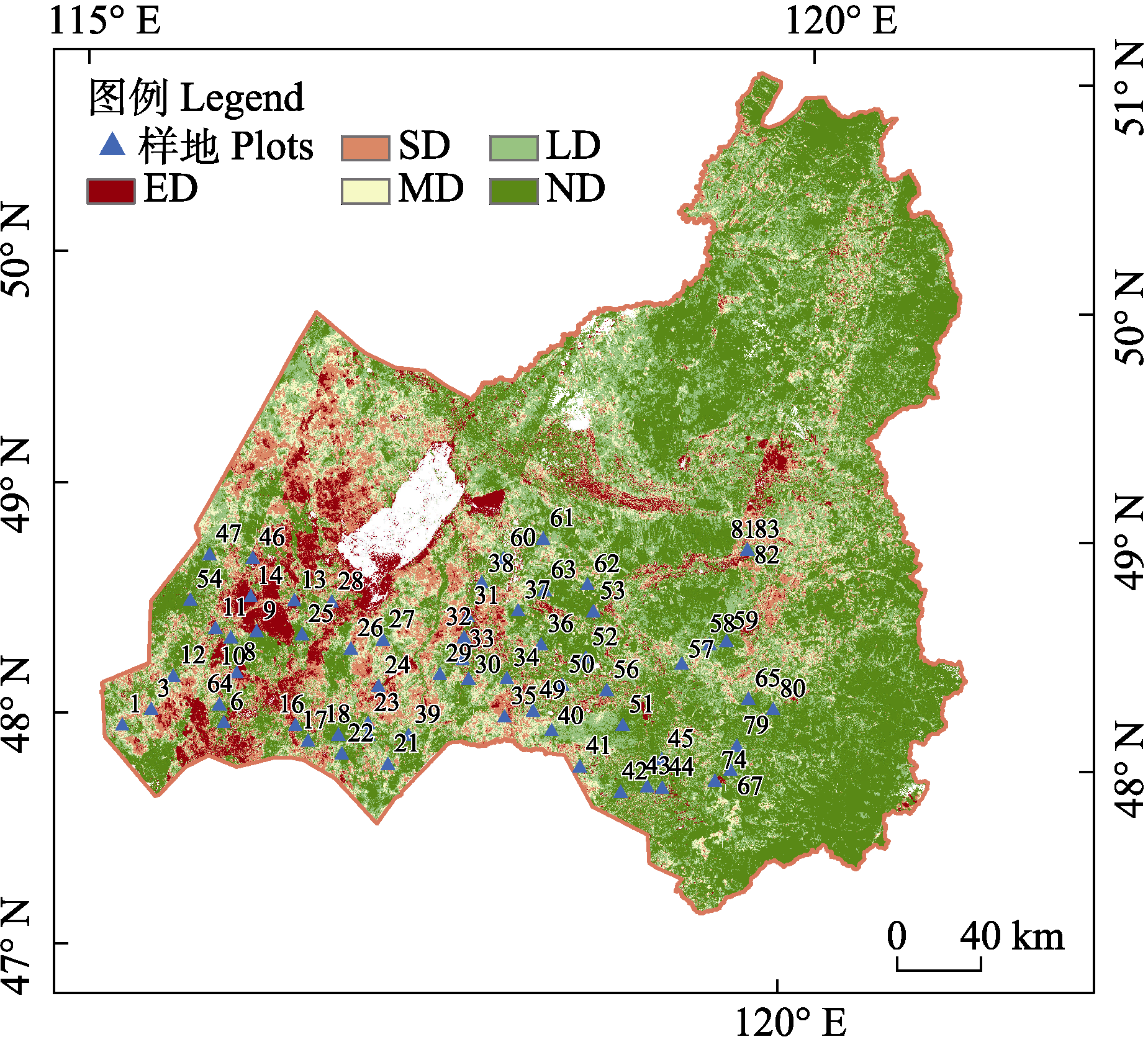
图1 2023年呼伦贝尔草地退化状况。ND: 未退化草地; LD: 轻度退化草地; MD: 中度退化草地; SD: 重度退化草地; ED: 极重度退化草地。图中数字代表样地编号。
Fig. 1 Degradation status of Hulunbuir grassland in 2023. ND, Non-degraded grassland; LD, Lightly degraded grassland; MD, Moderately degraded grassland; SD, Severely degraded grassland; ED, Extremely degraded grassland. Numbers in the figure represent the plot code.
| 退化等级 Degradation grade | 样地编号 Plot code |
|---|---|
| ND | 6, 13, 34, 36, 40, 51, 52, 53, 59, 62, 64, 65, 74, 81, 82 |
| LD | 12, 14, 24, 26, 27, 29, 37, 42, 45, 58, 79, 83 |
| MD | 1, 3, 19, 23, 25, 30, 31, 47, 56, 57, 60 |
| SD | 10, 11, 21, 28, 41, 43, 44, 46, 50, 54, 61, 63, 67, 80 |
| ED | 8, 9, 16, 17, 18, 22, 32, 33, 35, 38, 39, 49 |
表1 样地退化等级表。ND: 未退化草地; LD: 轻度退化草地; MD: 中度退化草地; SD: 重度退化草地; ED: 极重度退化草地。
Table 1 Degradation grade table of sample plots. ND, Non-degraded grassland; LD, Lightly degraded grassland; MD, Moderately degraded grassland; SD, Severely degraded grassland; ED, Extremely degraded grassland.
| 退化等级 Degradation grade | 样地编号 Plot code |
|---|---|
| ND | 6, 13, 34, 36, 40, 51, 52, 53, 59, 62, 64, 65, 74, 81, 82 |
| LD | 12, 14, 24, 26, 27, 29, 37, 42, 45, 58, 79, 83 |
| MD | 1, 3, 19, 23, 25, 30, 31, 47, 56, 57, 60 |
| SD | 10, 11, 21, 28, 41, 43, 44, 46, 50, 54, 61, 63, 67, 80 |
| ED | 8, 9, 16, 17, 18, 22, 32, 33, 35, 38, 39, 49 |
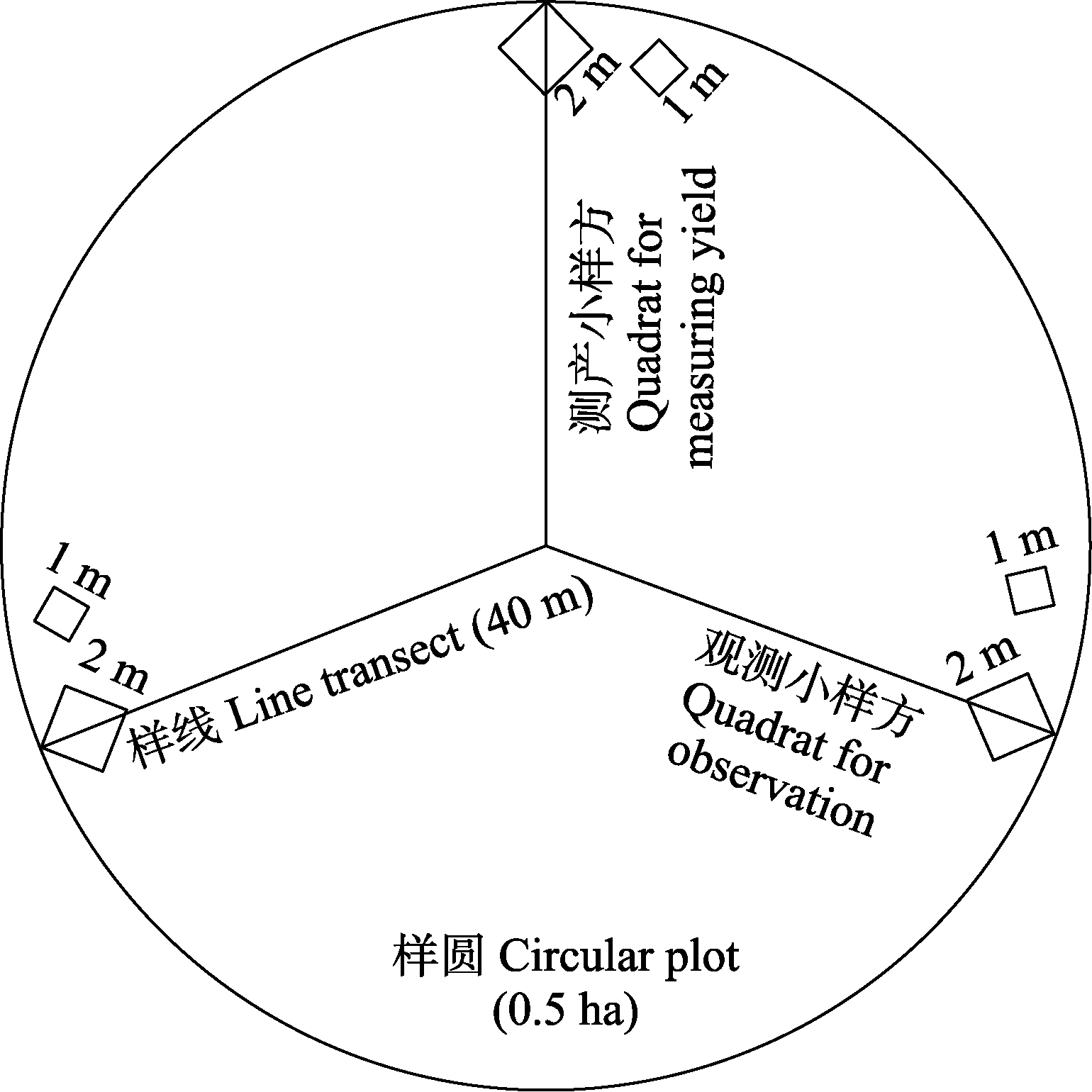
图2 样地设置示意图
Fig. 2 Schematic diagram of plot setup
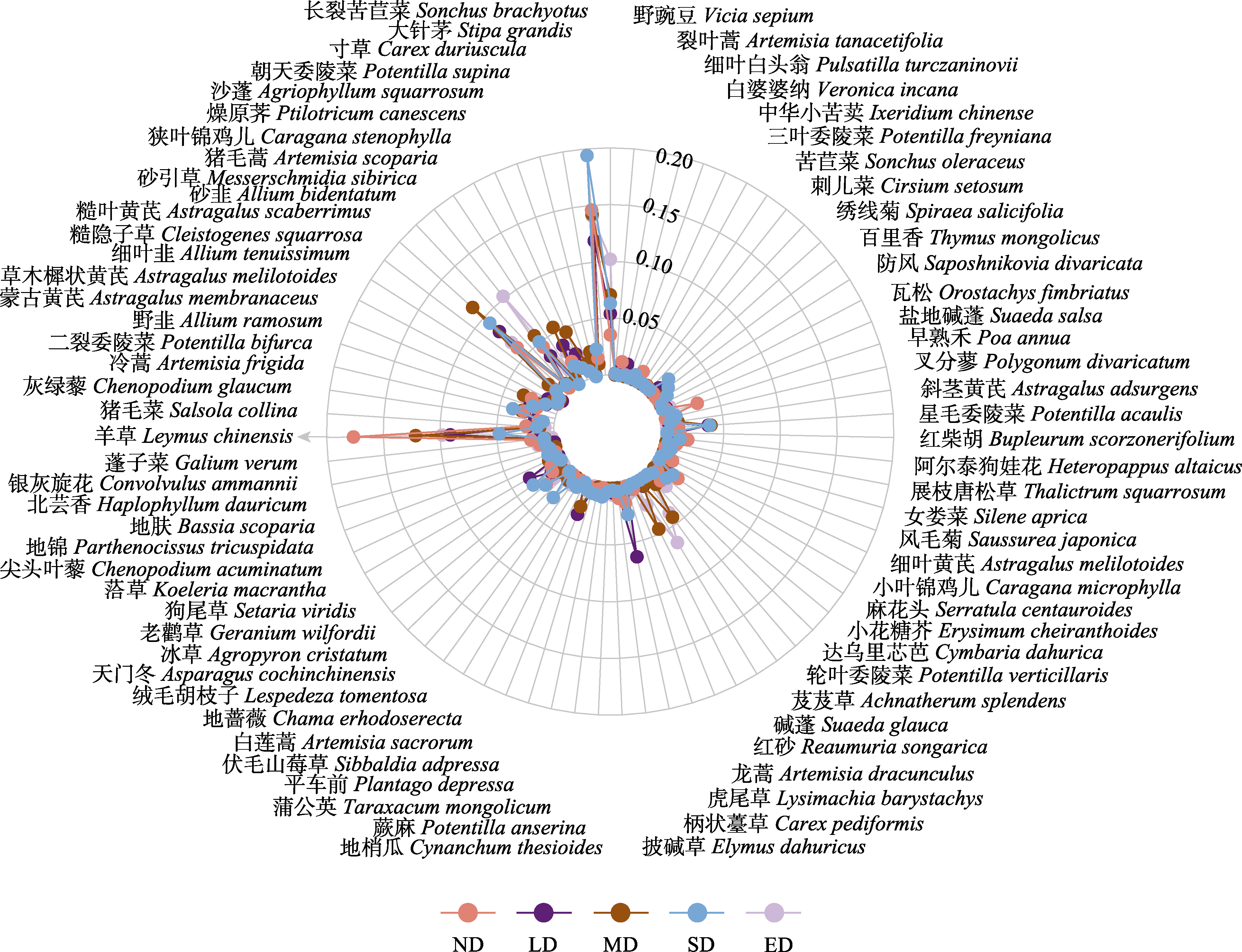
图3 不同退化阶段草地植物重要值雷达图。ND: 未退化草地; LD: 轻度退化草地; MD: 中度退化草地; SD: 重度退化草地; ED: 极重度退化草地。
Fig. 3 Radar map of plant importance values at different stages of degradation gassland. ND, Non-degraded grassland; LD, Lightly degraded grassland; MD, Moderately degraded grassland; SD, Severely degraded grassland; ED, Extremely degraded grassland.
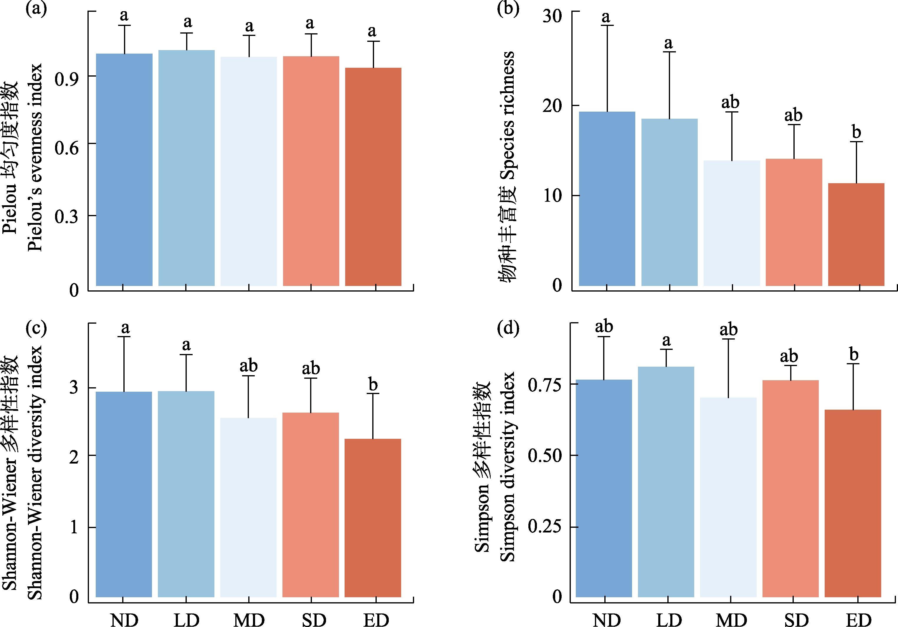
图4 不同退化阶段草地植物多样性指数比较(平均值 ± 标准差)。ND: 未退化草地; LD: 轻度退化草地; MD: 中度退化草地; SD: 重度退化草地; ED: 极重度退化草地。不同小写字母表示差异显著(P < 0.05)。
Fig. 4 Comparison of plant diversity indices at different stages of degradation grassland (mean ± SD). ND, Non-degraded grassland; LD, Lightly degraded grassland; MD, Moderately degraded grassland; SD, Severely degraded grassland; ED, Extremely degraded grassland. Different lowercase letters indicate significant differences (P < 0.05).
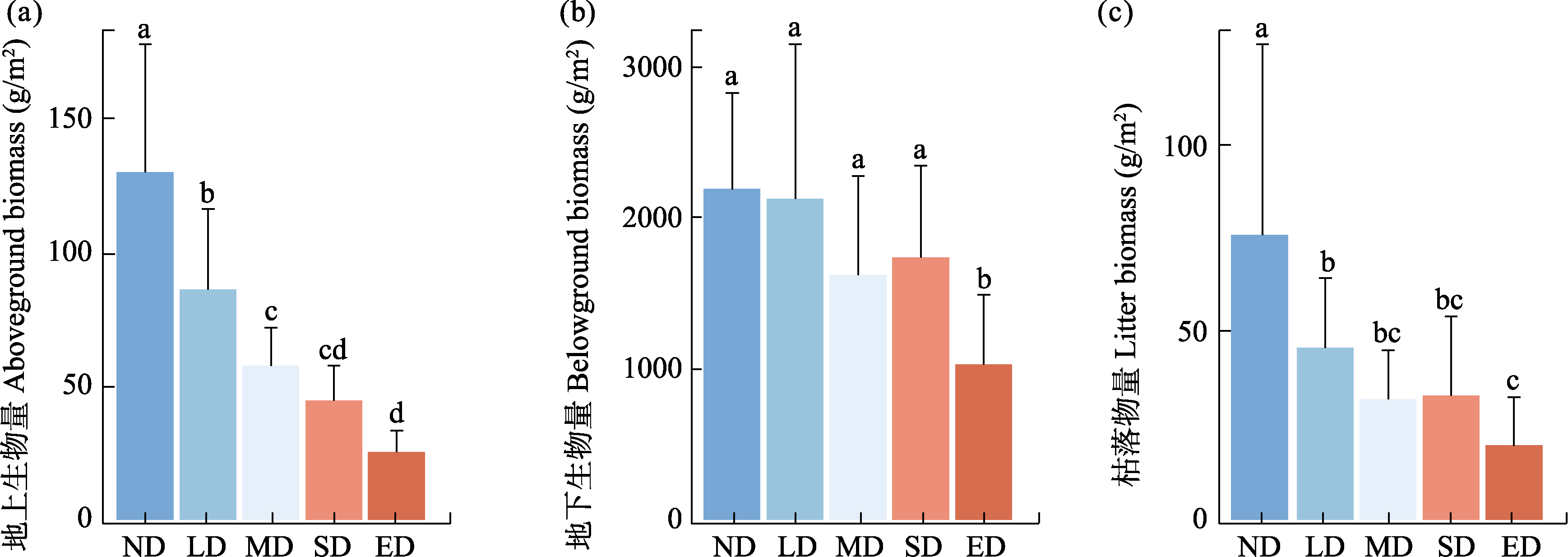
图5 不同退化阶段草地地上生物量(a)、地下生物量(b)、枯落物量(c)比较(平均值 ± 标准差)。ND: 未退化草地; LD: 轻度退化草地; MD: 中度退化草地; SD: 重度退化草地; ED: 极重度退化草地。不同小写字母表示差异显著(P < 0.05)。
Fig. 5 Comparison of aboveground biomass, bellowground biomass and litter at different stages of degradation grassland (mean ± SD). ND, Non-degraded grassland; LD, Lightly degraded grassland; MD, Moderately degraded grassland; SD, Severely degraded grassland; ED, Extremely degraded grassland. Different lowercase letters indicate significant differences (P < 0.05).
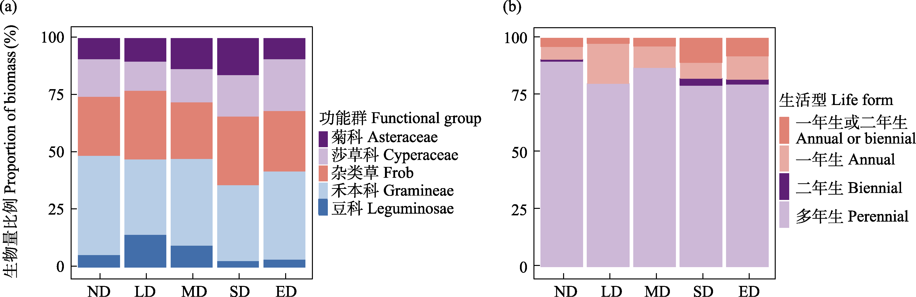
图6 不同退化阶段草地植物功能群(a)和生活型(b)生物量比例图。ND: 未退化草地; LD: 轻度退化草地; MD: 中度退化草地; SD: 重度退化草地; ED: 极重度退化草地。
Fig. 6 Plots of plant functional group biomass proportions at different stages of degradation grassland. ND, Non-degraded grassland; LD, Lightly degraded grassland; MD, Moderately degraded grassland; SD, Severely degraded grassland; ED, Extremely degraded grassland.
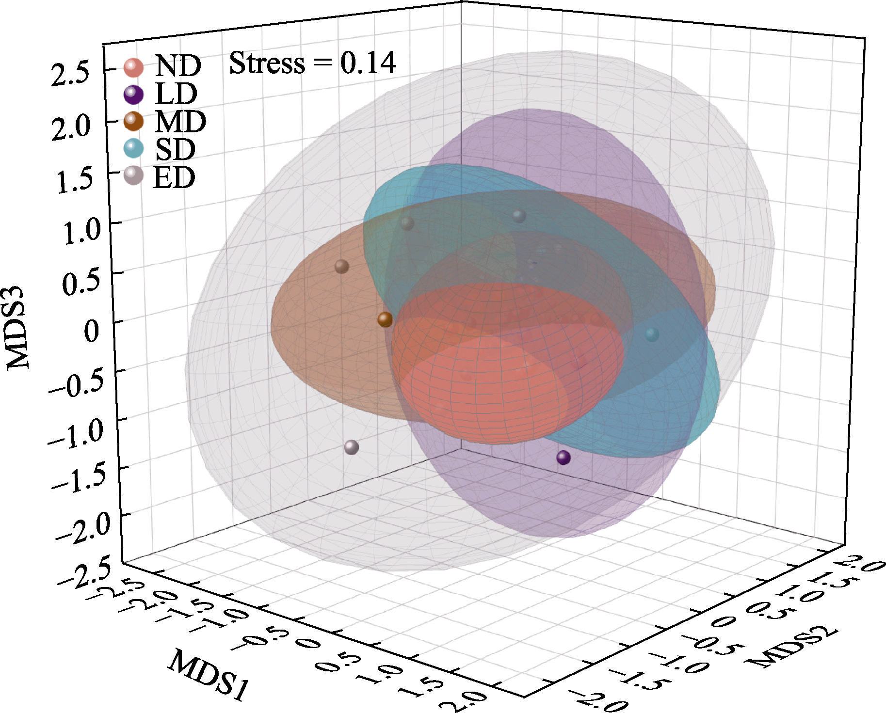
图7 不同退化阶段草地植被分布的非度量多维尺度分析图。ND: 未退化草地; LD: 轻度退化草地; MD: 中度退化草地; SD: 重度退化草地; ED: 极重度退化草地。
Fig. 7 Non-metric multidimensional scaling analysis of vegetation distribution at different degradation grassland. ND, Non-degraded grassland; LD, Lightly degraded grassland; MD, Moderately degraded grassland; SD, Severely degraded grassland; ED, Extremely degraded grassland.
| [1] | Angassa A (2014) Effects of grazing intensity and bush encroachment on herbaceous species and rangeland condition in southern Ethiopia. Land Degradation & Development, 25, 438-451. |
| [2] |
Auffret AG, Kimberley A, Plue J, Waldén E (2018) Super-regional land-use change and effects on the grassland specialist flora. Nature Communications, 9, 3464.
DOI PMID |
| [3] |
Bai YF, Wu JG, Xing Q, Pan QM, Huang JH, Yang DL, Han XG (2008) Primary production and rain use efficiency across a precipitation gradient on the Mongolia Plateau. Ecology, 89, 2140-2153.
PMID |
| [4] | Bardgett RD, Bullock JM, Lavorel S, Manning P, Schaffner U, Ostle N, Chomel M, Durigan G, Fry EL, Johnson D, Lavallee JM, Le Provost G, Luo S, Png K, Sankaran M, Hou XY, Zhou HK, Ma L, Ren WB, Li XL, Ding Y, Li YH, Shi HX (2021) Combatting global grassland degradation. Nature Reviews Earth & Environment, 2, 720-735. |
| [5] | Chen Y, Yin PD, Chen W, Pan WJ (2013) Progress of mechanism model in plant photosynthate allocation. Plant Physiology Journal, 49, 425-436. (in Chinese with English abstract) |
| [ 陈懿, 尹鹏达, 陈伟, 潘文杰 (2013) 植物光合产物分配的机理模型的研究进展. 植物生理学报, 49, 425-436.] | |
| [6] | Craine JM, Dybzinski R (2013) Mechanisms of plant competition for nutrients, water and light. Functional Ecology, 27, 833-840. |
| [7] |
Craine JM, Morrow C, Stock WD (2008) Nutrient concentration ratios and co-limitation in South African grasslands. New Phytologist, 179, 829-836.
DOI PMID |
| [8] | Delecti Florae Reipublicae Popularis Sinicae Agendae Academiae Sinicae (2004) Flora Reipublicae Popularis Sinicae. Science Press, Beijing. (in Chinese) |
| [ 中国科学院中国植物志编辑委员会 (2004) 中国植物志. 科学出版社, 北京.] | |
| [9] | Dudenhöffer JH, Luecke NC, Crawford KM (2022) Changes in precipitation patterns can destabilize plant species coexistence via changes in plant-soil feedback. Nature Ecology & Evolution, 6, 546-554. |
| [10] | Fu ZY, Jiang H, Wang GQ, A YL, Xue BL, Wang HQ (2018) Effects of soil properties on plant community structure in a semi-arid grassland. Chinese Journal of Ecology, 37, 823-830. (in Chinese with English abstract) |
| [ 傅致远, 姜宏, 王国强, 阿膺兰, 薛宝林, 王红旗 (2018) 半干旱草原区土壤性质对植物群落结构的影响. 生态学杂志, 37, 823-830.] | |
| [11] | Gan S, Xiao Y, Xu J, Wang YY, Yu FQ, Xie GD (2019) Comprehensive cost-benefit evaluation of the Hulunbuir grassland meadow ecological function area. Acta Ecologica Sinica, 39, 5874-5884. (in Chinese with English abstract) |
| [ 甘爽, 肖玉, 徐洁, 王洋洋, 余付勤, 谢高地 (2019) 呼伦贝尔草原草甸生态功能区建设效益评价. 生态学报, 39, 5874-5884.] | |
| [12] | Han GD, Jiao SY, Biligetu, Aodenggaowa (2007) Effects of plant species diversity and productivity under different stocking rates in the Stipa breviflora Griseb. desert steppe. Acta Ecologica Sinica, 27, 182-188. (in Chinese with English abstract) |
| [ 韩国栋, 焦树英, 毕力格图, 敖登高娃 (2007) 短花针茅草原不同载畜率对植物多样性和草地生产力的影响. 生态学报, 27 182-188.] | |
| [13] | Han X, Li YH, Du XF, Li YB, Wang ZW, Jiang SW, Li Q (2020) Effect of grassland degradation on soil quality and soil biotic community in a semi-arid temperate steppe. Ecological Processes, 9, 63. |
| [14] | Harris RB (2010) Rangeland degradation on the Qinghai-Tibetan Plateau: A review of the evidence of its magnitude and causes. Journal of Arid Environments, 74, 1-12. |
| [15] | Kang L, Han XG, Zhang ZB, Sun OJ (2007) Grassland ecosystems in China, Review of current knowledge and research advancement. Philosophical Transactions of the Royal Society B: Biological Sciences, 362, 997-1008. |
| [16] | Li B (1997) Grassland degradation and its control measures in northern China. Scientia Agricultura Sinica, 30, 1-10. (in Chinese with English abstract) |
|
[ 李博 (1997) 中国北方草地退化及其防治对策. 中国农业科学, 30, 1-10.]
DOI |
|
| [17] | Li WL, Liu C, Wang W, Zhou HK, Xue Y, Xu J, Xue P, Yan H (2021) Effects of different grazing disturbances on the plant diversity and ecological functions of alpine grassland ecosystem on the Qinghai-Tibetan Plateau. Frontiers in Plant Science, 12,765070. |
| [18] | Liu ZL, Wang W, Hao DY, Liang CZ (2002) Probes on the degeneration and recovery succession mechanisms of Inner Mongolia steppe. Journal of Arid Land Resources and Environment, 16(1), 84-91. (in Chinese with English abstract) |
| [ 刘钟龄, 王炜, 郝敦元, 梁存柱 (2002) 内蒙古草原退化与恢复演替机理的探讨. 干旱区资源与环境 16( 1), 84-91.] | |
| [19] | Ma HZ, Mo LD, Crowther TW, Maynard DS, van den Hoogen J, Stocker BD, Terrer C, Zohner CM (2021) The global distribution and environmental drivers of aboveground versus belowground plant biomass. Nature Ecology & Evolution, 5, 1110-1122. |
| [20] | Mo Y, Bao YJ, Li ZH, Zhang J, Wu WG, Wu S, Tang JZ, Wu WZ, Xu MR, Li M (2023) Impacts of grassland degradation on vegetation carbon pool in Hulun Buir. Journal of Inner Mongolia University (Natural Science Edition), 54(1), 61-68. (in Chinese with English abstract) |
| [ 莫宇, 鲍雅静, 李政海, 张靖, 武文广, 吴帅, 唐吉喆, 吴伟赜, 徐梦冉, 李蔓 (2023) 呼伦贝尔草原退化对植被碳库的影响. 内蒙古大学学报(自然科学版), 54(1), 61-68.] | |
| [21] | Pi WQ (2021) Recongnition and Classification of Land Features of Grassland Degradation Indicators Based on UAV Hyperspectral Remote Sensing. PhD dissertation, Inner Mongolia Agricultural University, Hohhot. (in Chinese with English abstract) |
| [ 皮伟强 (2021) 基于无人机高光谱遥感的草原退化指标地物的识别与分类研究. 博士学位论文, 内蒙古农业大学, 呼和浩特.] | |
| [22] | Pielou EC (1966) The measurement of diversity in different types of biological collections. Journal of Theoretical Biology, 13, 131-144. |
| [23] | Ren H, Li ZA, Shen WJ, Yu ZY, Peng SL, Liao CH, Ding MM, Wu JG (2007) Changes in biodiversity and ecosystem function during the restoration of a tropical forest in south China. Science in China Series C, Life Sciences, 50, 274-284. |
| [24] | Ren JZ (1985) Grassland Science and Grassland Survey Planning. China Agriculture Press, Beijing. (in Chinese) |
| [ 任继周 (1985) 草原学与草原调查与规划. 中国农业出版社, 北京.] | |
| [25] | Shannon CE (1948) A mathematical theory of communication. Bell System Technical Journal, 27, 379-423. |
| [26] | Simpson EH (1949) Measurement of diversity. Nature, 163, 688. |
| [27] | Song XX, Wang L, Zhao X, Liu C, Chang Q, Wang Y, Xu TT, Wang DL (2017) Sheep grazing and local community diversity interact to control litter decomposition of dominant species in grassland ecosystem. Soil Biology and Biochemistry, 115, 364-370. |
| [28] | Sun LA, Liang YM, Liu GB (1993) Review of research on subsurface biomass of grassland. Grassland and Turf, 13(1), 6-13. (in Chinese with English abstract) |
| [ 孙力安, 梁一民, 刘国彬 (1993) 草地地下生物量研究综述. 国外畜牧学、草原与牧草, 13(1), 6-13.] | |
| [29] | Tilman D, Wedin D, Knops J (1996) Productivity and sustainability influenced by biodiversity in grassland ecosystems. Nature, 379, 718-720. |
| [30] | Wang BZ, Zhu YJ, Shan D, Liu YS, Yang XH (2019) Effects of community degradation of Hulun Buir typical steppe on its species diversity and biomass. Journal of Plant Resources and Environment, 28(4), 68-76. (in Chinese with English abstract) |
| [ 王百竹, 朱媛君, 山丹, 刘艳书, 杨晓晖 (2019) 呼伦贝尔典型草原群落退化对其物种多样性及生物量的影响. 植物资源与环境学报, 28(4), 68-76.] | |
| [31] | Wang HJ, Fan WJ, Cui YK, Zhou L, Yan BY, Wu DH, Xu XR (2010) Hyperspectral remote sensing of grassland degradation. Spectroscopy and Spectral Analysis, 30, 2734-2738. (in Chinese with English abstract) |
| [ 王焕炯, 范闻捷, 崔要奎, 周磊, 闫彬彦, 吴代晖, 徐希孺 (2010) 草地退化的高光谱遥感监测方法. 光谱学与光谱分析, 30, 2734-2738.] | |
| [32] | Wang MM, Liu XP, He YH, Zhang TH, Wei J, Che L, Sun SS (2019) How enclosure influences restored plant community changes of different initial types in Horqin Sandy Land. Chinese Journal of Plant Ecology, 43, 672-684. (in Chinese with English abstract) |
|
[ 王明明, 刘新平, 何玉惠, 张铜会, 魏静, 车力木格, 孙姗姗 (2019) 科尔沁沙地封育恢复过程中植物群落特征变化及影响因素. 植物生态学报, 43, 672-684.]
DOI |
|
| [33] | Wang XX, Dong SK, Yang B, Li YY, Su XK (2014) The effects of grassland degradation on plant diversity, primary productivity, and soil fertility in the alpine region of Asia’s headwaters. Environmental Monitoring and Assessment, 186, 6903-6917. |
| [34] | Wang XY, Chen XS, Ding QP, Zhao XY, Wang XJ, Ma ZW, Lian J (2018) Vegetation and soil environmental factor characteristics, and their relationship at different desertification stages: A case study in the Minqin desert-oasis ecotone. Acta Ecologica Sinica, 38, 1569-1580. (in Chinese with English abstract) |
| [ 王新源, 陈翔舜, 丁乾平, 赵学勇, 王小军, 马仲武, 连杰 (2018) 不同荒漠化阶段植被生态特征对土壤环境因子的响应——以民勤荒漠绿洲过渡带为例. 生态学报, 38, 1569-1580.] | |
| [35] | Wang YH, Zhou GS (2004) Responses of temporal dynamics of aboveground net primary productivity of Leymus chinensis community to precipitation fluctuation in Inner Mongolia. Acta Ecologica Sinica, 24, 1140-1145. (in Chinese with English abstract) |
| [ 王玉辉, 周广胜 (2004) 内蒙古羊草草原植物群落地上初级生产力时间动态对降水变化的响应. 生态学报, 24, 1140-1145.] | |
| [36] | Xiao HL, Zhou HC, Yao YJ, Chen JG, Lin D, Zhang DG (2023) Analysis on vegetation and soil characteristics of alpine grassland with different degradation degrees in Three Rivers Region. Grassland and Turf, 43(2), 85-91. (in Chinese with English abstract) |
| [ 肖海龙, 周会程, 姚玉娇, 陈建纲, 林栋, 张德罡 (2023) 三江源地区不同退化程度高寒草原植被与土壤特征分析. 草原与草坪, 43(2), 85-91.] | |
| [37] |
Xie GD, Zhang YL, Lu CX, Zheng D, Cheng SK (2001) Study on valuation of rangeland ecosystem services of China. Journal of Natural Resources, 16(1), 47-53. (in Chinese with English abstract)
DOI |
| [ 谢高地, 张钇锂, 鲁春霞, 郑度, 成升魁 (2001) 中国自然草地生态系统服务价值. 自然资源学报, 16(1), 47-53.] | |
| [38] |
Xie Y, Sha Z, Yu M (2008) Remote sensing imagery in vegetation mapping: A review. Journal of Plant Ecology, 1, 9-23.
DOI |
| [39] |
Xu HP, Zhang J, Pang XP, Wang Q, Zhang WN, Wang J, Guo ZG (2019) Responses of plant productivity and soil nutrient concentrations to different alpine grassland degradation levels. Environmental Monitoring and Assessment, 191, 678.
DOI PMID |
| [40] | Yan W, Hugejiletu, Narenmandula (2016) Analysis of climate change characteristics in Hulunbuir grassland—A case study of Chen Bahu Banner. Inner Mongolia Science Technology & Economy, (16), 58-60. (in Chinese) |
| [ 闫炜, 呼格吉勒图, 那仁满都拉 (2016) 呼伦贝尔草原气候变化特征简析——以陈巴尔虎旗为例. 内蒙古科技与经济, (16), 58-60.] | |
| [41] | Yu ZH, Dong QM, Cao Q, Yu Y, Zhang CP, Liu WT, Yang XX, Liu YZ, Zhang ZX, Feng B, Lv WD, Yang ZZ (2023) Effects of different grazing patterns on plant community characteristics of alpine meadows in Qilian Mountains. Acta Agrestia Sinica, 31, 2621-2627. (in Chinese with English abstract) |
|
[ 于泽航, 董全民, 曹铨, 俞旸, 张春平, 刘文亭, 杨晓霞, 刘玉祯, 张振祥, 冯斌, 吕卫东, 杨增增 (2023) 不同放牧模式对祁连山高寒草甸植物群落特征的影响. 草地学报, 31, 2621-2627.]
DOI |
|
| [42] |
Yuan ZY, Jiao F, Li YH, Kallenbach RL (2016) Anthropogenic disturbances are key to maintaining the biodiversity of grasslands. Scientific Reports, 6, 22132.
DOI PMID |
| [43] |
Zhao S, Yang WQ, Lin BJ, Qiao QL, Wu YR, Li QY, Zhang SX, Han XZ, Li XL, Kou JC (2023) Plant and soil characteristics of different degraded alpine meadows in Qilian Mountain National Park. Acta Agrestia Sinica, 31, 1530-1538. (in Chinese with English abstract)
DOI |
|
[ 赵帅, 杨文权, 蔺宝珺, 乔千洛, 武燕茹, 李钦瑶, 张生祥, 韩显忠, 李希来, 寇建村 (2023) 祁连山国家公园不同退化高寒草甸植物与土壤特性研究. 草地学报, 31, 1530-1538.]
DOI |
|
| [44] | Zhou M, Yang Q, Zhang HJ, Yao XD, Zeng WJ, Wang W (2020) Plant community temporal stability in response to nitrogen addition among different degraded grasslands. Science of the Total Environment, 729, 138886. |
| [45] | Zhu N, Wang H, Ning XG, Liu YF (2021) Advances in remote sensing monitoring of grassland degradation. Science of Surveying and Mapping, 46(5), 66-76. (in Chinese with English abstract) |
| [ 朱宁, 王浩, 宁晓刚, 刘娅菲 (2021) 草地退化遥感监测研究进展. 测绘科学, 46(5), 66-76.] |
| [1] | 梁健超, 陈淑甜, 何文祥, 熊春妮, 许镇洲, 黄源欣, 刘源志弘, 张浪, 胡慧建. 广州市陆生野生脊椎动物资源——编目、分布与保护[J]. 生物多样性, 2026, 34(5): 25422-. |
| [2] | 黄莉, 刘志发, 龚粤宁, 李步杭, 张健. 广东南岭16个1 ha森林动态监测样地植物群落组成与结构[J]. 生物多样性, 2026, 34(3): 25357-. |
| [3] | 夏东坡, 李静, 田军东, 黄中豪, 伍乘风, 陈仕望, 李进华. 中国野生猕猴属动物的研究进展[J]. 生物多样性, 2026, 34(3): 25460-. |
| [4] | 周婷婷, 张浩淼, 王浩杰, 廖健, 陈晓丹, 杨楠, 韩博平, 刘振元. 广东省蜻蜓目物种多样性空间格局及关键影响因素[J]. 生物多样性, 2026, 34(2): 25337-. |
| [5] | 罗熙, 王啟芳, 王建佳, 杨倩曦, 方鸿飞, 洪淼, 张琦, 蔡灵, 周曦杰, 黄丁勇, 郑新庆. 福建东山海域新记录种揭示我国北缘造礁石珊瑚群落多样性[J]. 生物多样性, 2026, 34(2): 25335-. |
| [6] | 刘振元, 周婷婷, 王伟民, 韩博平, 谢志才. 城市化对深圳地区河流大型底栖无脊椎动物群落物种多样性和功能多样性的影响机制[J]. 生物多样性, 2025, 33(9): 25135-. |
| [7] | 冯缨, 宋凤, 金光照, Komiljon Tojibaev, 葛学军. 中亚荒漠区沙拐枣属的分布格局与物种多样性[J]. 生物多样性, 2025, 33(8): 25086-. |
| [8] | 杨洋, 邹睿, 谯娅琴, 孟想, 涂飞云. 海南省陆生哺乳动物物种多样性[J]. 生物多样性, 2025, 33(8): 25044-. |
| [9] | 于琦胧, 郝珉辉, 何怀江, 张春雨, 赵秀海. 长白山森林不同演替阶段生物多样性与生产力的关系: 基于物种、性状和系统发育的视角[J]. 生物多样性, 2025, 33(8): 25060-. |
| [10] | 章洋, 王彦平. SLOSS争论研究进展: 分析方法、理论机制及保护实践[J]. 生物多样性, 2025, 33(7): 25081-. |
| [11] | 潘正东, 林熙戎, 薛华, 胡治颖, 郭弘艺, 张亚, 吴阿娜, 唐文乔. 上海主要内陆水体鱼类物种多样性本底及群落结构[J]. 生物多样性, 2025, 33(6): 24290-. |
| [12] | 彭文, 邓泽帅, 郑文宝, 龚凌轩, 曾玉枫, 孟昊, 陈军, 杨道德. eDNA技术在两栖动物调查中的应用: 以湖南莽山国家级自然保护区为例[J]. 生物多样性, 2025, 33(6): 24552-. |
| [13] | 张璐璐, 任昭杰, 于宁宁, 赵奉熙, 赵遵田. 甘肃省苔藓植物名录[J]. 生物多样性, 2025, 33(6): 24451-. |
| [14] | 吴晓晴, 张美惠, 葛苏婷, 李漫淑, 达良俊, 宋坤, 沈国春, 张健. 上海近自然林重建过程中木本植物物种多样性与地上生物量的时空动态: 以闵行区生态岛为例[J]. 生物多样性, 2025, 33(5): 24444-. |
| [15] | 王太, 宋福俊, 张永胜, 娄忠玉, 张艳萍, 杜岩岩. 河西走廊内陆河水系鱼类多样性及资源现状[J]. 生物多样性, 2025, 33(4): 24387-. |
| 阅读次数 | ||||||
|
全文 |
|
|||||
|
摘要 |
|
|||||
备案号:京ICP备16067583号-7
Copyright © 2026 版权所有 《生物多样性》编辑部
地址: 北京香山南辛村20号, 邮编:100093
电话: 010-62836137, 62836665 E-mail: biodiversity@ibcas.ac.cn
![]()