
生物多样性 ›› 2018, Vol. 26 ›› Issue (8): 905-917. DOI: 10.17520/biods.2018049 cstr: 32101.14.biods.2018049
• 综述 • 上一篇
刘方正1,2, 杜金鸿1,2, 周越1,2, 黄志旁3, 李延鹏3, 王伟1,2,*( ), 肖文3
收稿日期:2018-02-09
接受日期:2018-07-10
出版日期:2018-08-20
发布日期:2018-09-27
通讯作者:
王伟
基金资助:
Liu Fangzheng1,2, Du Jinhong1,2, Zhou Yue1,2, Huang Zhipang3, Li Yanpeng3, Wang Wei1,2,*(), Xiao Wen3
Received:2018-02-09
Accepted:2018-07-10
Online:2018-08-20
Published:2018-09-27
Contact:
Wang Wei
摘要:
无人机技术的运用为自然保护地生物多样性监测与研究带来了新的机遇和变革。然而, 对自然保护地主要保护对象的关注不足, 导致了无人机和地面相结合的监测技术尚未形成。为更好地发挥多种调查监测技术的各自优势, 为自然保护地生物多样性管护和监测提供支撑, 我们总结了国内外已开展的无人机和地面相结合的监测工作进展, 梳理了我国不同类型自然保护地生物多样性保护管理和监测的需求。总的来看, 不同类型自然保护地的主要保护对象围绕在生态系统、物种、遗址遗迹等或由上述要素构成的景观资源上; 管理目标定位则集中在保护、恢复、科研、宣教、游憩和可持续发展等方面。基于上述需求, 我们归纳提出了包括图像识别与分类解译、数据反演与格局分析、数字建模与地表测量、巡护巡检4个类别共计14个专题的无人机和地面相结合的监测技术方案, 明确了监测时期与频次、监测指标、监测技术的结合途径以及数据后处理方法等。同时, 我们在三江并流世界遗产地云岭片区内选择植物识别、植被长势、景观格局、地表测量以及执法检查等技术专题开展了应用试验。在技术方案取得良好验证结果的同时, 实现了对自然保护地生物多样性保护和管理的技术支撑, 为未来自然保护地精细化管理提供了技术储备。
刘方正, 杜金鸿, 周越, 黄志旁, 李延鹏, 王伟, 肖文 (2018) 无人机和地面相结合的自然保护地生物多样性监测技术与实践. 生物多样性, 26, 905-917. DOI: 10.17520/biods.2018049.
Liu Fangzheng, Du Jinhong, Zhou Yue, Huang Zhipang, Li Yanpeng, Wang Wei, Xiao Wen (2018) Monitoring technology and practice on protected area biodiversity by integrating unmanned aerial vehicle (UAV) and ground approaches. Biodiversity Science, 26, 905-917. DOI: 10.17520/biods.2018049.
 |
表1 不同类型自然保护地生物多样性检测需求
Table 1 Biodiversity monitoring demands of different protected area types
| |
 |
表2 无人机和地面相结合的自然保护地生物多样性检测技术方案
Table 2 The technology solution for protected area biodiversity monitoring by integrating unmanned aerial vehicle(UAV) and ground approaches
| |
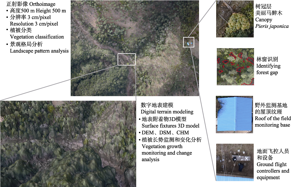
图1 无人机和地面相结合的监测技术方案在三江并流世界遗产地中的应用
Fig. 1 The technology solution by integrating unmanned aerial vehicle (UAV) and ground approaches was applicated in the Three Parallel Rivers World Heritage
| [1] | Anderson K, Gaston KJ (2013) Lightweight unmanned aerial vehicles will revolutionize spatial ecology. Frontiers in Ecology and the Environment, 11, 138-146. |
| [2] | Chabot D, Bird DM (2015) Wildlife research and management methods in the 21st century: Where do unmanned aircraft fit in. Journal of Unmanned Vehicle Systems, 3, 137-155. |
| [3] | Chai ZW, Kang J, Wang L, Zhao X, Qiao HL (2015) The construction of DEM in mountain plantation landscape based on UAV images. Remote Sensing Technology and Application, 30, 504-509. (in Chinese with English abstract) |
| [柴子为, 康峻, 王力, 赵昕, 乔海浪 (2015) 基于无人机影像的山地人工林景观DEM构建. 遥感技术与应用, 30, 504-509.] | |
| [4] | Chiara T, Andrea B, Federico C, Salvatore FDG, Beniamino G, Alessandro M, Franco M, Carolina V, Alessandro Z, Luke W (2017) Forestry applications of UAVs in Europe: A review. International Journal of Remote Sensing, 38, 2427-2447. |
| [5] | Christiansen F, Dujon AM, Sprogis KR, Arnould JPY, Bejder L (2016) Noninvasive unmanned aerial vehicle provides estimates of the energetic cost of reproduction in humpback whales.Ecosphere 7(10): e01468. 10.1002/ecs2.1468. |
| [6] | Christie KS, Gilbert SL, Brown CL, Hatfield M, Hanson L (2016) Unmanned aircraft systems in wildlife research: Current and future applications of a transformative technology. Frontiers in Ecology and the Environment, 14, 241-251. |
| [7] | Dai SQ, Zhao B (2016) Trends and challenges of ecosystem observations in the age of big data. Biodiversity Science, 24, 85-94. (in Chinese with English abstract) |
| [戴圣骐, 赵斌 (2016) 大数据时代下的生态系统观测发展趋势与挑战. 生物多样性, 24, 85-94.] | |
| [8] | Dunford R, Michel K, Gagnage M, Piégay H, Trémelo ML (2009) Potential and constraints of unmanned aerial vehicle technology for the characterization of Mediterranean riparian forest. International Journal of Remote Sensing, 30, 4915-4935. |
| [9] | Durban JW, Fearnbach H, Barrett-Lennard LG, Perryman WL, Leroi DJ (2015) Photogrammetry of killer whales using a small hexacopter launched at sea. Journal of Unmanned Vehicle Systems, 3, 131-135. |
| [10] | Fang JY, Wang XP, Shen ZH, Tang ZY, He JS, Yu D, Jiang Y, Wang ZH, Zheng CY, Zhu JL, Guo ZD (2009) Methods and protocols for plant community inventory. Biodiversity Science, 17, 533-548. (in Chinese with English abstract) |
| [方精云, 王襄平, 沈泽昊, 唐志尧, 贺金生, 于丹, 江源, 王志恒, 郑成洋, 朱江玲, 郭兆迪 (2009) 植物群落清查的主要内容、方法和技术规范. 生物多样性, 17, 533-548.] | |
| [11] | Feng JL, Liu K, Zhu YH, Li Y, Liu L, Meng L (2015) Application of unmanned aerial vehicles to mangrove resources monitoring. Tropical Geography, 35, 35-42. (in Chinese with English abstract) |
| [冯家莉, 刘凯, 朱远辉, 李勇, 柳林, 蒙琳 (2015) 无人机遥感在红树林资源调查中的应用. 热带地理, 35, 35-42.] | |
| [12] | Fu WJ, Hong JY, Lin MS (2006) A method of land use classification from remote sensing image based on support vector machines and spectral similarity scale. Remote Sensing Technology and Application, 21, 25-30. (in Chinese with English abstract) |
| [傅文杰, 洪金益, 林明森 (2006) 基于光谱相似尺度的支持向量机遥感土地利用分类. 遥感技术与应用, 21, 25-30.] | |
| [13] | Garzon-Lopez CX, Bohlman SA, Olff H, Jansen PA (2013) Mapping tropical forest trees using high-resolution aerial digital photographs. Biotropica, 45, 308-316. |
| [14] | Ge J, Meng BP, Yang SX, Gao JL, Feng QS, Liang TG, Huang XD, Gao XH, Li WL, Zhang RP, Wang YL (2017) Dynamic monitoring of alpine grassland coverage based on UAV technology and MODIS remote sensing data —— A case study in the headwater of the Yellow River. Acta Prataculturae Sinica, 26, 1-12. (in Chinese with English abstract) |
| [葛静, 孟宝平, 杨淑霞, 高金龙, 冯琦胜, 梁天刚, 黄晓东, 高新华, 李文龙, 张仁平, 王云龙 (2017) 基于UAV技术和MODIS遥感数据的高寒草地盖度动态变化监测研究——以黄河源东部地区为例. 草业学报, 26, 1-12.] | |
| [15] | Getzin S, Wiegand K, Schöning I (2012) Assessing biodiversity in forests using very high-resolution images and unmanned aerial vehicles. Methods in Ecology and Evolution, 3, 397-404. |
| [16] | Gonzalez LF, Montes GA, Puig E, Johnson S, Mengersen K, Gaston KJ (2016) Unmanned aerial vehicles (UAVs) and artificial intelligence revolutionizing wildlife monitoring and conservation. Sensors, 16, 97-115. |
| [17] | Gotelli NJ, Colwell RK (2001) Quantifying biodiversity: Procedures and pitfalls in the measurement and comparison of species richness. Ecology Letters, 4, 379-391. |
| [18] | Graham CH, Hijmans RJ (2006) A comparison of methods for mapping species ranges and species richness. Global Ecology and Biogeography, 15, 578-587. |
| [19] | Guo QH, Wu FF, Hu TY, Chen LH, Liu J, Zhao XQ, Gao S, Pang SX (2016) Perspectives and prospects of unmanned aerial vehicle in remote sensing monitoring of biodiversity. Biodiversity Science, 24, 1267-1278. (in Chinese with English abstract) |
| [郭庆华, 吴芳芳, 胡天宇, 陈琳海, 刘瑾, 赵晓倩, 高上, 庞树鑫 (2016) 无人机在生物多样性遥感监测中的应用现状与展望. 生物多样性, 24, 1267-1278.] | |
| [20] | Guo ZH, Xiao WF, Jiang YX (2003) Applications of remote sensing to monitoring forest canopy dynamics. Chinese Journal of Plant Ecology, 27, 851-858. (in Chinese with English abstract) |
| [郭志华, 肖文发, 蒋有绪 (2003) 遥感在林冠动态监测研究中的应用. 植物生态学报, 27, 851-858.] | |
| [21] | He YY, Zhang YB, Li JQ, Wang JL (2016) Estimation of stem biomass of individual Abies faxoniana through unmanned aerial vehicle remote sensing. Journal of Beijing Forestry University, 38, 42-49. (in Chinese with English abstract) |
| [何游云, 张玉波, 李俊清, 王卷乐 (2016) 利用无人机遥感测定岷江冷杉单木树干生物量. 北京林业大学学报, 38, 42-49.] | |
| [22] | Hodgson A, Kelly N, Peel D (2013) Unmanned aerial vehicles (UAVs) for surveying marine fauna: A dugong case study. PLoS ONE, 8, e79556. |
| [23] | Holmgren J, Åsa P (2004) Identifying species of individual trees using airborne laser scanner. Remote Sensing of Environment, 90, 415-423. |
| [24] | Hu HD, Li XY, Du YF, Zheng HF, Du BX, He XY (2012) Research advances in biodiversity remote sensing monitoring. Chinese Journal of Ecology, 31, 1591-1596. (in Chinese with English abstract) |
| [胡海德, 李小玉, 杜宇飞, 郑海峰, 都本绪, 何兴元 (2012) 生物多样性遥感监测方法研究进展. 生态学杂志, 31, 1591-1596.] | |
| [25] | Hu JB, Zhang J (2018) Unmanned aerial vehicle remote sensing in ecology: Advances and prospects. Acta Ecologica Sinica, 38, 20-30. (in Chinese with English abstract) |
| [胡健波, 张健 (2018) 无人机遥感在生态学中的应用进展. 生态学报, 38, 20-30.] | |
| [26] | Husson E, Hagner O, Ecke F (2014) Unmanned aircraft systems help to map aquatic vegetation. Applied Vegetation Science, 17, 567-577. |
| [27] | Israel M (2011) A UAV-based roe deer fawn detection system. International Archives of the Photogrammetry, Remote Sensing and Spatial Information Sciences. XXXVIII-1/C22, 51-55 |
| [28] | Jing R, Deng L, Zhao WJ, Gong ZN (2016) Object-oriented aquatic vegetation extracting approach based on visible vegetation indices. Chinese Journal of Applied Ecology, 27, 1427-1436. (in Chinese with English abstract) |
| [井然, 邓磊, 赵文吉, 宫兆宁 (2016) 基于可见光植被指数的面向对象湿地水生植被提取方法. 应用生态学报, 27, 1427-1436.] | |
| [29] | Koski WR, Allen T, Ireland D, Buck G, Smith PR, Macrander AM, Halick MA, Rushing C, Sliwa DJ, McDonald TL (2009) Evaluation of an unmanned airborne system for monitoring marine mammals. Aquatic Mammals, 35, 347-357. |
| [30] | Li FX (2017) Application and discussion of UAV technology in ecological remote sensing monitoring of grassland. Bulletin of Surveying and Mapping, (7), 99-102. (in Chinese with English abstract) |
| [李风贤 (2017) 无人机技术在草原生态遥感监测中的应用与探讨. 测绘通报, (7), 99-102.] | |
| [31] | Li JS, Zhu YP, Luo ZL, Luo JW, Xin LJ, Li BY (2018) Study and Practice on National Park System. China Environment Publishing Group,Beijing. (in Chinese) |
| [李俊生, 朱彦鹏, 罗遵兰, 罗建武, 辛丽娟, 李博炎 (2018) 国家公园体制研究与实践. 中国环境出版集团, 北京.] | |
| [32] | Li X, Zheng YW, Dai CY, Lin WS (2017) Research progress of forest information acquisition based on unmanned aerial vehicle (UAV) image. World Forestry Research, 30(4), 41-46. (in Chinese with English abstract) |
| [李祥, 郑淯文, 戴楚彦, 林文树 (2017) 基于无人机影像的森林信息获取研究进展. 世界林业研究, 30(4), 41-46.] | |
| [33] | Li XM, Zhang J, Ma Y, Ren GB (2017) Study on monitoring alien invasive species Spartina alterniflora using unmanned aerial vehicle hyperspectral remote sensing—A case study of the Yellow River Delta. Marine Sciences, 41, 98-107. (in Chinese with English abstract) |
| [李晓敏, 张杰, 马毅, 任广波 (2017) 基于无人机高光谱的外来入侵种互花米草遥感监测方法研究——以黄河三角洲为研究区. 海洋科学, 41, 98-107.] | |
| [34] | Luke W, Arko L, Christopher W, Darren T (2012) Development of a UAV-LiDAR system with application to forest inventory. Remote Sensing, 4, 1519-1543. |
| [35] | Luo W, Shao QQ, Wang DL, Wang YC (2017) An object - oriented classification method for detection of large wild herbivores: A case study in the source region of three rivers in Qinghai. Chinese Journal of Wildlife, 38, 561-564. (in Chinese with English abstract) |
| [罗巍, 邵全琴, 王东亮, 汪阳春 (2017) 基于面向对象分类的大型野生食草动物识别方法——以青海三江源地区为例. 野生动物学报, 38, 561-564.] | |
| [36] | Lü AF, Zhou L, Zhu WB (2014) The remote sensing based dynamic monitoring of land desertification in Qinghai Province. Remote Sensing Technology and Application, 29, 803-811. (in Chinese with English abstract) |
| [吕爱锋, 周磊, 朱文彬 (2014) 青海省土地荒漠化遥感动态监测. 遥感技术与应用, 29, 803-811.] | |
| [37] | Ma KP (2011) Assessing progress of biodiversity conservation with monitoring approach. Biodiversity Science, 19, 125-126. (in Chinese) |
| [马克平 (2011) 监测是评估生物多样性保护进展的有效途径. 生物多样性, 19, 125-126.] | |
| [38] | Ma KP (2014) China’s forest biodiversity monitoring network decade development. Chinese Science Bulletin, 59, 2331-2332. (in Chinese) |
| [马克平 (2014) 中国森林生物多样性监测网络十年发展. 科学通报, 59, 2331-2332.] | |
| [39] | Ma KP (2016) Hot topics for biodiversity science. Biodiversity Science, 24, 1-2. (in Chinese) |
| [马克平 (2016) 生物多样性科学的热点问题. 生物多样性, 24, 1-2.] | |
| [40] | Ma T, Zheng JH, Wen AM, Chen M, Liu ZJ (2018) Group coverage of burrow entrance and distribution characteristics of desert forest-dwelling Rhombomys opimus based on unmanned aerial vehicles (UAV) low-altitude remote sensing: A case study at the southern margin of the Gurbantunggut Desert in Xinjiang. Acta Ecologica Sinica, 38, 953-963. (in Chinese with English abstract) |
| [马涛, 郑江华, 温阿敏, 陈梦, 刘忠军 (2018) 基于UAV低空遥感的荒漠林大沙鼠洞群覆盖率及分布特征研究——以新疆古尔班通古特沙漠南缘局部为例. 生态学报, 38, 953-963.] | |
| [41] | Mi XC, Guo J, Hao ZQ, Xie ZQ, Guo K, Ma KP (2016) Chinese forest biodiversity monitoring: Scientific foundations and strategic planning. Biodiversity Science, 24, 1203-1219. (in Chinese with English abstract) |
| [米湘成, 郭静, 郝占庆, 谢宗强, 郭柯, 马克平 (2016) 中国森林生物多样性监测: 科学基础与执行计划. 生物多样性, 24, 1203-1219.] | |
| [42] | NOAA (2014) Spying on Sperm Whales. |
| [43] | Panagiotidis D, Abdollahnejad A, Surovy P, Chiteculo V (2016) Determining tree height and crown diameter from high-resolution UAV imagery. International Journal of Remote Sensing, 38, 2392-2410. |
| [44] | Pecl GT, Araújo MB, Bell JD, Blanchard J, Bonebrake TC, Chen IC, Clark TD, Colwell RK, Danielsen F, Evengård B, Falconi L, Ferrier S, Frusher S, Garcia RA, Griffis RB, Hobday AJ, Janion-Scheepers C, Jarzyna MA, Jennings S, Lenoir J, Linnetved HI, Martin VY, McCormack PC, McDonald J, Mitchell NJ, Mustonen T, Pandolfi JM, Pettorelli N, Popova E, Robinson SA, Scheffers BR, Shaw JD, Sorte CJB, Strugnell JM, Sunday JM, Tuanmu M, Vergés A, Villanueva C, Wernberg T, Wapstra E, Williams SE (2017) Biodiversity redistribution under climate change: Impacts on ecosystems and human well-being. Science, 355, 1-9. |
| [45] | Peng YJ, Fan J, Xing SH, Cui GF (2018) Overview and classification outlook of natural protected areas in mainland China. Biodiversity Science, 26, 315-325. (in Chinese with English abstract) |
| [彭杨靖, 樊简, 邢韶华, 崔国发 (2018) 中国大陆自然保护地概况及分类体系构想. 生物多样性, 26, 315-325.] | |
| [46] | Quan J, Ouyang ZY, Xu WH, Miao H (2010) Comparison and applications of methodologies for management effectiveness assessment of protected areas. Biodiversity Science, 18, 90-99. (in Chinese with English abstract) |
| [权佳, 欧阳志云, 徐卫华, 苗鸿 (2010) 自然保护区管理有效性评价方法的比较与应用. 生物多样性, 18, 90-99.] | |
| [47] | Sui DD, Wang Y, Lian JY, Zhang J, Hu JB, Ouyang XJ, Fan ZJ, Cao HL, Ye WH (2017) Gap distribution patterns in the south subtropical evergreen broad-leaved forest of Dinghushan. Biodiversity Science, 25, 382-392. (in Chinese with English abstract) |
| [隋丹丹, 王悦, 练琚愉, 张健, 胡健波, 欧阳学军, 范宗骥, 曹洪麟, 叶万辉 (2017) 鼎湖山南亚热带常绿阔叶林林窗分布格局及其成因. 生物多样性, 25, 382-392.] | |
| [48] | Sun YL, Zhou CP, Shi PL, Song MH, Xiong DP (2014) The variability of grassland net primary production in Tibet and its responses to no grazing project. Chinese Journal of Grassland, 36, 1-12. (in Chinese with English abstract) |
| [孙银良, 周才平, 石培礼, 宋明华, 熊定鹏 (2014) 西藏高寒草地净初级生产力变化及其对退牧还草工程的响应. 中国草地学报, 36, 1-12.] | |
| [49] | Tang XP, Luan XF (2017) Developing a nature protected area system composed mainly of national parks. Forest Resources Management, (6), 1-8. (in Chinese with English abstract) |
| [唐小平, 栾晓峰 (2017) 构建以国家公园为主体的自然保护地体系. 林业资源管理, (6), 1-8.] | |
| [50] | Tian LQ, Lin C, Zhang Q, Chen ZG (2014) Topology reliability design and optimization analysis of IoT-based monitoring. Journal of Software, 25, 1625-1639. (in Chinese with English abstract) |
| [田立勤, 林闯, 张琪, 陈振国 (2014) 物联网监测拓扑可靠性设计与优化分析. 软件学报, 25, 1625-1639.] | |
| [51] | Turner W (2014) Sensing biodiversity. Science, 346, 301-302. |
| [52] | Vermeulen C, Lejeune P, Lisein J, Sawadogo P, Bouché P (2013) Unmanned aerial survey of elephants. PLoS ONE, 8, e54700. |
| [53] | Wan H, Wang Q, Jiang D, Fu J, Yang Y, Liu X (2014) Monitoring the invasion of Spartina alterniflora using very high resolution unmanned aerial vehicle imagery in Beihai, Guangxi (China). The Scientific World Journal, 2014, 1-8. |
| [54] | Wang D, Xin X, Shao Q, Brolly M, Zhu Z, Chen J (2017) Modeling aboveground biomass in Hulunber grassland ecosystem by using unmanned aerial vehicle discrete lidar. Sensors, 17, 180-198. |
| [55] | Yang L, Sun ZY, Tang GL, Lin ZW, Chen YQ, Li Y, Li Y (2016) Identifying canopy species of subtropical forest by lightweight unmanned aerial vehicle remote sensing. Tropical Geography, 36, 833-839. (in Chinese with English abstract) |
| [杨龙, 孙中宇, 唐光良, 林志文, 陈燕乔, 黎喻, 李勇 (2016) 基于微型无人机遥感的亚热带林冠物种识别. 热带地理, 36, 833-839.] | |
| [56] | Yang L, Yu J, Liu Y, Zhan DC (2017) Research progress on cognitive-oriented multi-source data learning theory and algorithm. Journal of Software, 28, 2971-2991. (in Chinese with English abstract) |
| [杨柳, 于剑, 刘烨, 詹德川 (2017) 面向认知的多源数据学习理论和算法研究进展. 软件学报, 28, 2971-2991.] | |
| [57] | Zweig CL, Burgess MA, Percival HF, Kitchens WM (2015) Use of unmanned aircraft systems to delineate fine-scale wetland vegetation communities. Wetlands, 35, 303-309. |
| [1] | 梁竣策, 李开枝, 谭烨辉. 南海翼足类物种多样性与分布[J]. 生物多样性, 2026, 34(5): 25487-. |
| [2] | 周丽洁, 郝珉辉, 何怀江, 程艳霞, 张春雨, 赵秀海. 小兴安岭森林β多样性格局、组分及其影响因素[J]. 生物多样性, 2026, 34(4): 25443-. |
| [3] | 彭昀月, 彭奎, 刘昕然, 孙天怡, 张小全. 生物多样性信用的企业参与途径、市场发展障碍与建议[J]. 生物多样性, 2026, 34(4): 26031-. |
| [4] | 李伯尧, 盛天成, 幸小云. 生物多样性风险对企业财务绩效的影响: 来自中国上市公司的证据[J]. 生物多样性, 2026, 34(4): 25330-. |
| [5] | 刘昊, 张玉霄, 刘冰, 李飞飞, 马洪峥, 覃海宁, 李德铢, 陈文俐. 中国禾本科植物多样性及其物种名录[J]. 生物多样性, 2026, 34(4): 25438-. |
| [6] | 孔孜亦, 王德港, 王建涛, 裴志永, 孙晶, 张长春, 张军国. 基于SCD-HRNet模型的野生动物姿态估计及其在生物多样性监测中的应用: 以内蒙古赛罕乌拉地区为例[J]. 生物多样性, 2026, 34(4): 25287-. |
| [7] | 朱浩友, 周友兵, 罗怡, 周昭敏. 南充市城区繁殖鸟类群落20年前后的变化[J]. 生物多样性, 2026, 34(3): 24560-. |
| [8] | 侯姝彧, 刘盈盈, 杨锐. 《昆蒙框架》背景下国际OECMs体系构建实践进展及中国化思路[J]. 生物多样性, 2026, 34(3): 25264-. |
| [9] | 程晓帆, 李青媛, 李媛辉, 张明祥. 外来入侵物种治理政策体系的困境与出路[J]. 生物多样性, 2026, 34(2): 25332-. |
| [10] | 陈璐露, 汤皓婷, 冷红, 袁青, 杨昕悦. 城市街区建成环境对生物多样性的影响[J]. 生物多样性, 2026, 34(2): 25286-. |
| [11] | 高雯琪, 向景荣, 赵耀, 范灵霜, 谷圆, 邵韦涵, 李高俊, 赵光军, 陈明斌, 蔡杏伟, 陈凯. 海南热带雨林国家公园黎母山和尖峰岭溪流鱼类群落特征及其对土地利用的响应[J]. 生物多样性, 2026, 34(2): 25374-. |
| [12] | 卢晓强, 芮丹, 张江峰, 尹冰鑫, 王雨露, 岑雨婷, 崔怡晨, 杨万霞. 氮输入驱动的关键生态过程对生物多样性的影响及其管理启示[J]. 生物多样性, 2026, 34(2): 25368-. |
| [13] | 谭廷鸿, 高帆, 杨雨, 肖群英, 吴春芳, 邱娜, 赵宁宁, 周敏, 康公平, 卢志宏, 高健强, 杨红, 杨传东, 邓春英. 中国西南喀斯特地区大型真菌物种编目[J]. 生物多样性, 2026, 34(2): 25281-. |
| [14] | 章旭日, 罗标, 赵彤, 黄丹, 艾为明. 浙江鱼类多样性: 编目、分布与保护[J]. 生物多样性, 2026, 34(2): 25225-. |
| [15] | 刘海鸥, 郝志明, 杜乐山, 刘文慧, 李子圆, 刘蕾. 全球生物多样性框架基金运行进展、挑战与启示[J]. 生物多样性, 2026, 34(2): 25463-. |
| 阅读次数 | ||||||
|
全文 |
|
|||||
|
摘要 |
|
|||||
备案号:京ICP备16067583号-7
Copyright © 2026 版权所有 《生物多样性》编辑部
地址: 北京香山南辛村20号, 邮编:100093
电话: 010-62836137, 62836665 E-mail: biodiversity@ibcas.ac.cn
![]()