生物多样性

• • 上一篇    下一篇

绵刺(Potaninia mongolica)群落地理分布及其分类数据集

王艺璇1,2,李浩1,2,孙蔷3,李紫晶4,李明乐1,2,史亚博5,郑颖4,李星6,莫宇1,2,范磊1,2,郭肖1,2,苗百岭7,韩瀛8,莎娜9,董雷4,张景慧1,2,李智勇1,2,王立新1,2,赵利清1,2,梁存柱1,2*    

  1. 1.内蒙古大学生态与环境学院,呼和浩特,010021 2.蒙古高原生态学与资源利用教育部重点实验室,呼和浩特,010021 3.内蒙古财经大学资源与环境经济学院,呼和浩特,010070 4.水利部牧区水利科学研究所,呼和浩特,010020 5.包头师范学院生态环境学院,内蒙古包头,014030 6.内蒙古自治区林业科学研究院,呼和浩特,010000 7.内蒙古自治区气象科学研究所,呼和浩特,010051 8.中共内蒙古自治区委员会党校,呼和浩特,010010 广东工业大学生态环境与资源学院,广州,510006
  • 收稿日期:2025-03-18 修回日期:2025-04-23 接受日期:2025-06-30
  • 通讯作者: 梁存柱

Dataset on Geographic Distribution and Classification of Potaninia mongolica Communities

Yixuan Wang1,2, Hao Li1,2, Qiang Sun3, Zijing Li4, Mingle Li1,2, Yabo Shi5,1, Ying Zheng4, Xing Li6, Yu Mo1,2, Lei Fan1,2, Xiao Guo1,2, Bailing Miao7, Ying Han8, Na Sha9,1, Lei Dong4, Jinghui Zhang1,2, Zhiyong Li1,2, Lixin Wang1,2 ,Cunzhu Liang1,2*   

  1. 1.College of Ecology and Environment, Inner Mongolia University, Hohhot, 01000 

    2.Key Laboratory of Mongolian Plateau Ecology and Resource Utilization,Ministry of Education,Hohhot,010021 

    3.School of Resource and Environmental Economics, Inner Mongolia University of Finance and Economics, Hohhot,010070 

    4.Institute of Water Resources for Pastoral Area, Ministry of Water Resources, Hohhot,010020, 

    5.College of Ecological Environment, Baotou Normal University, Baotou,014030 

    6.Inner Mongolia Academy of Forestry Science, Hohhot,010000 

    7.Inner Mongolia Institute of Meteorological Sciences, Hohhot,010051 

    8.Party School of Inner Mongolia Autonomous Regional Committee of CPC, Hohhot,010010 

    9. School of Ecology, Environment and Resources, Guangdong University of Technology,Guangzhou, 510006

  • Received:2025-03-18 Revised:2025-04-23 Accepted:2025-06-30
  • Contact: Cunzhu Liang

摘要: 
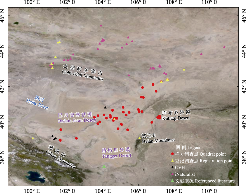
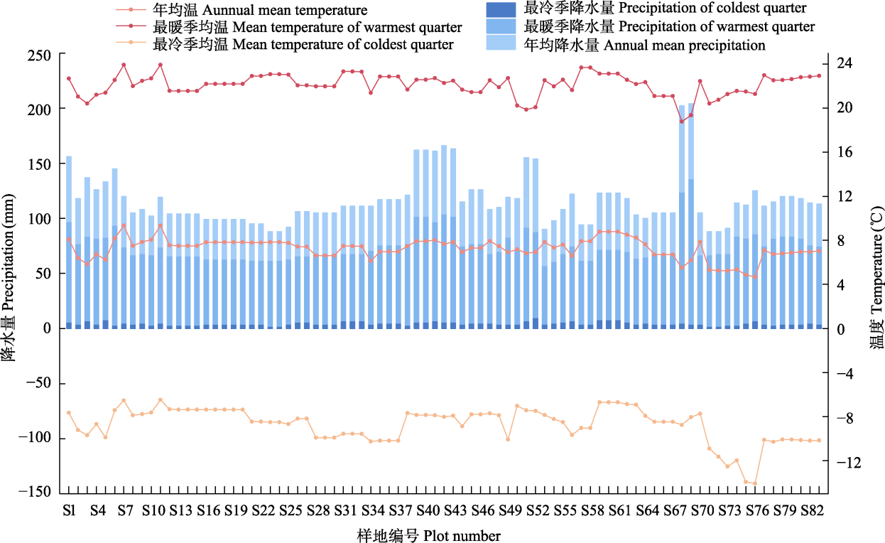
国家二级保护野生植物绵刺(Potaninia mongolica)是一种第三纪孑遗物种,其形成的群落构成了亚非荒漠区东翼特有的荒漠景观。该文以1998年9月至2024年8月的野外调查数据为基础,结合相关文献资料,对绵刺荒漠群落的地理分布、群落特征及其群丛划分进行了研究,调查点分别位于内蒙古自治区鄂尔多斯市鄂托克旗、杭锦旗;阿拉善盟阿拉善左旗、阿拉善右旗;巴彦淖尔市乌拉特后旗、乌拉特中旗;甘肃省武威市民勤县、张掖市临泽县以及蒙古国的南戈壁省和东戈壁省。共计83个绵刺群落样点,其中样方调查点67个,登记调查点16个。样方调查点是在绵刺群落内随机布设1–3个10 m × 10 m灌木样方(部分早期样方面积略小),并划分为4个5 m × 5 m小样方,如有草本植物则再在小样方内设1 m × 1 m的草本样方。完整记录灌木、半灌木层每个物种的名称、高度、冠幅,以及草本层每个物种的名称、高度、丛幅和株数等生物参数。登记调查点记录了群落物种组成、优势物种及群落类型等基础信息。结果表明:(1)绵刺群落主要分布于蒙古高原荒漠区东部。(2)根据样地调查,绵刺荒漠群落记录到10科30属42种种子植物,其中乔木1种,灌木、半灌木各15种,多年生草本8种及一年生草本3种;水分生态类型中有21种强旱生植物和19种旱生植物。(3)根据优势种和群落结构,绵刺荒漠群落可分为绵刺温性灌木荒漠群丛组、绵刺-丛生禾草荒漠群丛组、绵刺-温性半灌木荒漠群丛组和绵刺-温性灌木荒漠群丛组,进一步可再划分为25个群丛。(4)绵刺群落生长于降水稀少的干旱、寒冷的荒漠气候区。本绵刺群落数据集内容丰富,资料价值高,是揭示绵刺群落地理分布、物种组成和结构等特征的重要凭证,可为深入了解绵刺群落的基本特征和《中国植被志》荒漠卷的编研提供基础数据。

关键词: 绵刺荒漠, 群落特征, 地理分布, 群落分类

AbstractPotaninia mongolica Maxim., a nationally protected plant species of Class II in China, is a Tertiary relict whose communities form a distinctive desert landscape on the eastern margin of the Afro-Asian desert region. Based on field survey data collected from September 1998 to August 2024, supplemented by relevant literature, this study investigates the geographical distribution, community characteristics, and phytocoenosis classification of Potaninia mongolica desert communities. Survey sites were located in Otog Banner and Hanggin Banner of Ordos City, Alxa Left Banner and Alxa Right Banner of Alxa League, Urad Rear Banner and Urad Middle Banner of Bayannur City in Inner Mongolia Autonomous Region, China, as well as Minqin County of Wuwei City and Linze County of Zhangye City in Gansu Province and the South Gobi Province and East Gobi Province of Mongolia. A total of 83 community investigation plots were established, including 67 quadrats and 16 registration plots. In the quadrat, one to three shrub quadrats (10 m × 10 m, with some early quadrats slightly smaller) were randomly placed within Potaninia mongolica communities, and each was divided into four sub-quadrats (5 m × 5 m). If herbaceous plants were present, herbaceous quadrats (1 m × 1 m) were established within the sub-quadrats. For each species in the shrub and semi-shrub layers, species name, height, and crown diameter were recorded. For the herbaceous layer, species name, height, clump diameter, and individual count were documented. The registration plots recorded basic information such as species composition, dominant species, and community types. The results showed that: (1) Potaninia mongolica communities are mainly distributed in the eastern part of the Mongolian Plateau desert region. (2) The field investigation was recorded 42 species of seed plants belonging to 30 genera and 10 families, including 1 tree species,15 shrub species, 15 semi-shrub species, 8 perennial herbaceous species and 3 annual herbaceous species. In terms of water ecological types, there were 21 strongly xerophytic species and 19 xerophytic species. (3) Based on dominant species and community structure, Potaninia mongolica desert communities can be classified into four community groups: the Potaninia mongolica temperate shrub desert group, the Potaninia mongolica-bunchgrass desert group, the Potaninia mongolica-temperate semi-shrub desert group, and the Potaninia mongolica-temperate shrub desert group, which can be further subdivided into 25 community types. (4) Potaninia mongolica communities occur in arid, cold desert climate zones characterized by very low precipitation. This Potaninia mongolica community dataset is comprehensive and of high scientific value, providing critical evidence for understanding the geographical distribution, species composition, and structural features of Potaninia mongolica communities. It offers essential baseline data for further research on the basic characteristics of these communities and supports the compilation of the “Desert Vegetation volume of the Vegetation of China”.

Key words: Potaninia mongolica desert, community characteristics, geographical distribution, community classification