
生物多样性 ›› 2019, Vol. 27 ›› Issue (9): 1021-1031. DOI: 10.17520/biods.2019166 cstr: 32101.14.biods.2019166
李顺,邹亮,宫一男,杨海涛,王天明,冯利民,葛剑平( )
)
收稿日期:2019-05-16
接受日期:2019-08-10
出版日期:2019-09-20
发布日期:2019-09-25
通讯作者:
葛剑平
基金资助:
Shun Li,Liang Zou,Yinan Gong,Haitao Yang,Tianming Wang,Limin Feng,Jianping Ge()
Received:2019-05-16
Accepted:2019-08-10
Online:2019-09-20
Published:2019-09-25
Contact:
Jianping Ge
摘要:
激光雷达(light detection and ranging, LiDAR)作为一门新兴的主动遥感技术, 近年来由于在提取和反演森林参数水平上不断提高, 被越来越多地应用于动物生态学研究中。本文通过整理和搜集国内外文献, 对激光雷达的技术特点及其在森林参数提取和动物生境上的研究进展进行综述, 指出当前基于LiDAR的森林参数反演算法主要服务于森林资源调查或林学研究, 缺少对动物生态或生理意义相关的参数量化信息。目前该技术在国内的动物生态学方面的应用较少, 尚未见文章发表。通过总结国外学者的研究, 分别从动物生境选择与三维森林结构的关系、栖息地立体生境制图、生物多样性评估和物种分布模型预测三个方面综述了LiDAR在动物生态学研究中的应用现状。相比传统方法, LiDAR技术提供的高精度三维结构信息, 能够显著提高动物生境质量的评估、生物多样性的监测水平和物种分布模型的评价精度, 有利于从机理上加深对物种生境选择和集群过程的理解。但目前LiDAR技术的应用主要集中在对已知的生态关系研究, 尤其是冠层结构与动物分布的关系, 缺少对林下层生活的动物生境质量和生物多样性的监测和评估, 同时很多有关动物生存和繁衍与立体生境的关系研究有待从LiDAR数据中进一步挖掘分析。未来应加强对森林林下层三维信息的提取, 提高林下层动物生境质量和生物多样性的监测水平, 同时建立适用于动物生态和生理意义相关的参数, 为动物生境质量和生物多样性的评估提供标准的量化指标。
李顺,邹亮,宫一男,杨海涛,王天明,冯利民,葛剑平 (2019) 激光雷达技术在动物生态学领域的研究进展. 生物多样性, 27, 1021-1031. DOI: 10.17520/biods.2019166.
Shun Li,Liang Zou,Yinan Gong,Haitao Yang,Tianming Wang,Limin Feng,Jianping Ge (2019) Advances in LiDAR technology in the field of animal ecology. Biodiversity Science, 27, 1021-1031. DOI: 10.17520/biods.2019166.
| 软件 Software | 类型 Type | 主要应用及特点 Application and characteristics |
|---|---|---|
| TerraSolid | 商业软件 Commercial software | 目前国内外航测部门广泛采用的软件, 用于点云、影像处理。A widely used software in aerial survey department at present, used for point cloud and image data processing. |
| ENVI LiDAR | 商业软件 Commercial software | 可以自动提取DEM/DSM/建筑物/植被等三维模型, 提取的信息可在其他平台(如ENVI、ArcGIS、Google Earth)进一步使用和分析, 提供二次开发接口。Automatically extracted 3D models such as DEM/DSM/buildings/vegetation, the extracted data can be further used and analyzed on other platforms (such as ENVI, ArcGIS and Google Earth), and provide secondary development interface. |
| Global Mapper LiDAR Module | 商业软件 Commercial software | 集成了一系列全面的点云处理工具和数据访问接口, 包括点云生成、自动分类及要素提取。Integrated a series of comprehensive point cloud processing tools and data access interface, including point cloud generation, automatic classification and element extraction. |
| Lastools | 商业软件 Commercial software | 提供高效点云处理算法的库, 支持点云格式转换、点云处理等常见的算法功能。Providing efficient point cloud processing algorithm library, and supporting the functions of point cloud format conversion, point cloud processing and other common algorithm. |
| Cloud Compare | 开源软件 Open source software | 提供了一些基本工具用于手动编辑和呈现3D点云数据及各种处理算法, 用于实现点云距离计算、空间统计分析、点云分割和几何特征估算。Providing some basic tools for manually editing and rendering 3D point cloud data and various processing algorithms, which are used to realize point cloud distance calculation, spatial statistical analysis, point cloud segmentation and geometric feature estimation. |
| Fusion | 开源软件 Open source software | 适合于林学和生态学研究, 可以提取多种点云获取的林业参数信息。Suitable for the study of forestry and ecology, and can extract the information of forestry parameters obtained from various point clouds. |
| RiALITY | 商业软件 Commercial software | 可在iPad上运行激光雷达数据可视化功能, 支持真彩色三维点云和导航功能。It can run LiDAR data visualization on the iPad, supporting true color 3D point cloud and navigation. |
| LP360 | 商业软件 Commercial software | 桌面软件, 可以独立或在ArcGIS环境中实现, 提供不同解决方案, 从快速可视化到一些扩展线产品, 包括地面点云自动分类和信息提取。Desktop software, which can be implemented independently or in ArcGIS environment, providing different solutions, from rapid visualization to some extension line products, including ground point cloud automatic classification and information extraction. |
| FME | 商业软件 Commercial software | 由加拿大Safe Software公司研发, 最大特点是支持超过300多种空间数据格式及相互转换, 包括点云数据。Developed by Company of Safe Software, Canada, supporting for more than 300 spatial data formats and conversions, including point cloud data. |
| LiDAR 360 | 商业软件 Commercial software | 由国内数字绿土公司研发, 有针对城市规划、林业、电力等不同行业应用需求的信息提取和模块分析, 尤其是针对林业应用的单木分割算法, 能够进行点云数据信息挖掘和超大数据处理功能。Developed by Green Valley Company in China, focusing on information extraction and analysis module for urban planning, forestry and electric power application, especially for forestry application of tree segmentation algorithm, with point cloud data mining and data processing functions. |
表1 国内外主流激光雷达数据处理软件
Table 1 The main softwares for LiDAR data processing of both domestic and overseas
| 软件 Software | 类型 Type | 主要应用及特点 Application and characteristics |
|---|---|---|
| TerraSolid | 商业软件 Commercial software | 目前国内外航测部门广泛采用的软件, 用于点云、影像处理。A widely used software in aerial survey department at present, used for point cloud and image data processing. |
| ENVI LiDAR | 商业软件 Commercial software | 可以自动提取DEM/DSM/建筑物/植被等三维模型, 提取的信息可在其他平台(如ENVI、ArcGIS、Google Earth)进一步使用和分析, 提供二次开发接口。Automatically extracted 3D models such as DEM/DSM/buildings/vegetation, the extracted data can be further used and analyzed on other platforms (such as ENVI, ArcGIS and Google Earth), and provide secondary development interface. |
| Global Mapper LiDAR Module | 商业软件 Commercial software | 集成了一系列全面的点云处理工具和数据访问接口, 包括点云生成、自动分类及要素提取。Integrated a series of comprehensive point cloud processing tools and data access interface, including point cloud generation, automatic classification and element extraction. |
| Lastools | 商业软件 Commercial software | 提供高效点云处理算法的库, 支持点云格式转换、点云处理等常见的算法功能。Providing efficient point cloud processing algorithm library, and supporting the functions of point cloud format conversion, point cloud processing and other common algorithm. |
| Cloud Compare | 开源软件 Open source software | 提供了一些基本工具用于手动编辑和呈现3D点云数据及各种处理算法, 用于实现点云距离计算、空间统计分析、点云分割和几何特征估算。Providing some basic tools for manually editing and rendering 3D point cloud data and various processing algorithms, which are used to realize point cloud distance calculation, spatial statistical analysis, point cloud segmentation and geometric feature estimation. |
| Fusion | 开源软件 Open source software | 适合于林学和生态学研究, 可以提取多种点云获取的林业参数信息。Suitable for the study of forestry and ecology, and can extract the information of forestry parameters obtained from various point clouds. |
| RiALITY | 商业软件 Commercial software | 可在iPad上运行激光雷达数据可视化功能, 支持真彩色三维点云和导航功能。It can run LiDAR data visualization on the iPad, supporting true color 3D point cloud and navigation. |
| LP360 | 商业软件 Commercial software | 桌面软件, 可以独立或在ArcGIS环境中实现, 提供不同解决方案, 从快速可视化到一些扩展线产品, 包括地面点云自动分类和信息提取。Desktop software, which can be implemented independently or in ArcGIS environment, providing different solutions, from rapid visualization to some extension line products, including ground point cloud automatic classification and information extraction. |
| FME | 商业软件 Commercial software | 由加拿大Safe Software公司研发, 最大特点是支持超过300多种空间数据格式及相互转换, 包括点云数据。Developed by Company of Safe Software, Canada, supporting for more than 300 spatial data formats and conversions, including point cloud data. |
| LiDAR 360 | 商业软件 Commercial software | 由国内数字绿土公司研发, 有针对城市规划、林业、电力等不同行业应用需求的信息提取和模块分析, 尤其是针对林业应用的单木分割算法, 能够进行点云数据信息挖掘和超大数据处理功能。Developed by Green Valley Company in China, focusing on information extraction and analysis module for urban planning, forestry and electric power application, especially for forestry application of tree segmentation algorithm, with point cloud data mining and data processing functions. |
| 方法 Methods | 参考文献 Reference | 树种 Tree species | 分割精度 Accuracy of segmentation |
|---|---|---|---|
| 区域增长 Region growing | Hyyppa et al, 2001 | 针叶林 Coniferous forest | - |
| “注水”算法 Pouring algorithm | Koch et al, 2006 | 针叶林、阔叶林 Coniferous forest and broad-leaved forest | 62% |
| 标记分水岭 Marked watershed | Chen et al, 2006 | 阔叶林 Broad-leaved forest | 64% |
| K均值聚类 K-means clustering | Morsdorf et al, 2004 | 针叶林 Coniferous forest | 61% |
| 图论归一化分割 Graph theory normalized segmentation | Reitberger et al, 2009 | 针叶林、阔叶林 Coniferous forests and broad-leaved forest | 66% |
| 基于区域增长和阈值判断结合 Based on the combination of regional growth and threshold judgment | Li et al, 2012 | 针阔混交林 Theropencedrymion | 94% |
| 相对最短路径 Relative shortest path | Tao et al, 2015 | 针叶林、阔叶林 Coniferous forest and broad-leaved forest | 83%-93% |
表2 主要单木分割算法比较
Table 2 Comparison of the main algorithms of single tree segmentation
| 方法 Methods | 参考文献 Reference | 树种 Tree species | 分割精度 Accuracy of segmentation |
|---|---|---|---|
| 区域增长 Region growing | Hyyppa et al, 2001 | 针叶林 Coniferous forest | - |
| “注水”算法 Pouring algorithm | Koch et al, 2006 | 针叶林、阔叶林 Coniferous forest and broad-leaved forest | 62% |
| 标记分水岭 Marked watershed | Chen et al, 2006 | 阔叶林 Broad-leaved forest | 64% |
| K均值聚类 K-means clustering | Morsdorf et al, 2004 | 针叶林 Coniferous forest | 61% |
| 图论归一化分割 Graph theory normalized segmentation | Reitberger et al, 2009 | 针叶林、阔叶林 Coniferous forests and broad-leaved forest | 66% |
| 基于区域增长和阈值判断结合 Based on the combination of regional growth and threshold judgment | Li et al, 2012 | 针阔混交林 Theropencedrymion | 94% |
| 相对最短路径 Relative shortest path | Tao et al, 2015 | 针叶林、阔叶林 Coniferous forest and broad-leaved forest | 83%-93% |
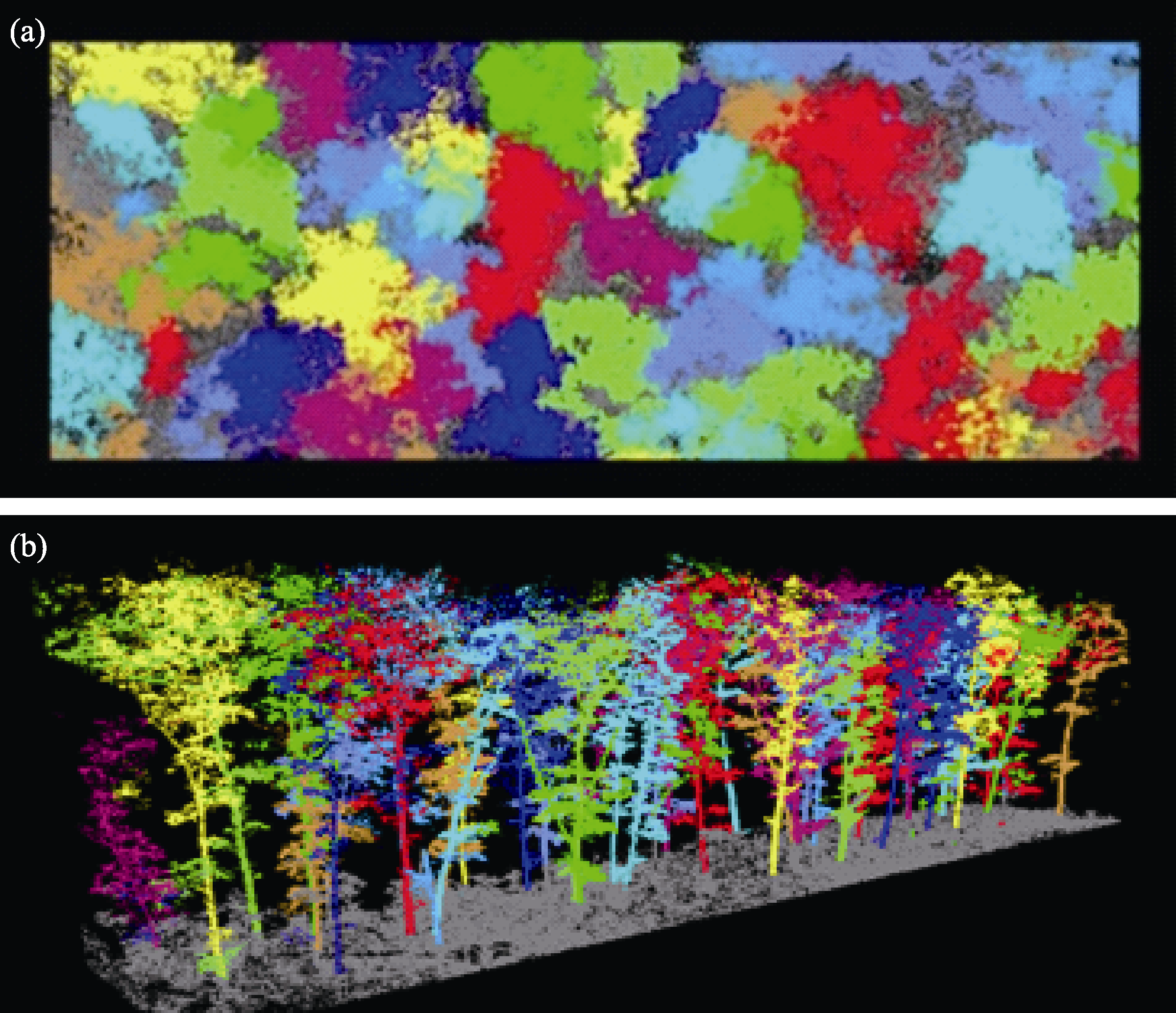
图1 基于相对最短路径算法的样地尺度单木分割效果。(a)俯视图; (b)正视图。获取平台: 地基激光雷达; 获取时间:2017年; 获取地点: 东北虎豹国家公园东部地区。
Fig. 1 Results of individual tree segmentation in plot scale by the relative shortest path algorithm based on terrestrial laser scanner. (a) Top view; (b) Front view. Platform: TLS; Captured time: 2017; Location: Eastern of National Park for Amur Tiger and Leopard
| 森林参数 Forest parameters | 参数描述 Parametric description | 与动物生境关系 Relationship with wildlife habitat | 参考文献 Reference |
|---|---|---|---|
| 郁闭度 Canopy cover | 指森林中乔木树冠在阳光直射下在地面的总投影面积(冠幅)与此林地(林分)总面积的比, 反映林分的密度。The ratio of the total projected area (canopy width) of the canopy on the ground under direct sunlight to the total area of the forest (forest stand), which reflects the density of the forest stand. | 大部分研究表明, 鸟类与蝙蝠类的活动与郁闭度高度相关; 有蹄类动物的季节选择与郁闭度相关。Most studies show that the activities of birds and bats are highly correlated with canopy density. Seasonal selection of ungulates is related to canopy cover. | Garabedian et al, 2014; Lone et al, 2014; Ewald et al, 2014; Melin et al, 2016b; Blakey et al, 2017 |
| 冠层高度 Canopy height | 是森林垂直生境结构的重要参数, 反映的是森林冠层距离地面的平均高度。An important parameter of forest vertical habitat structure, which reflects the average height of forest canopy from the ground. | 已有一些具有气候依赖性的鸟类在不同季节和不同气候条件下栖息的冠层高度不同; 鸟类和蝙蝠类动物的活动和占域在不同冠层高度上也呈现异质性。Some climate-dependent birds have different canopy heights in different seasons and climate. The activities and habitats of birds and bats are also present heterogeneous at different canopy heights. | Bradbury et al, 2005; Goetz et al, 2010; Garabedian et al, 2017; Blakey et al, 2017 |
| 冠层垂直分布 Canopy vertical distribution | 冠层部分在不同高度层枝叶的结构和密度分布情况。The structure and density distribution of canopy in different height layers. | 目前研究表明, 灵长类动物个体生境利用与冠层垂直分布相关。Current studies have shown that habitat use of individual primate is related to vertical canopy distribution. | Palminteri et al, 2012; Davies et al, 2019 |
| 林下层密度 Understory density | 单位面积内树冠以下部分枝叶和灌草的分布密集程度。Distribution density of branches, leaves and shrubs in the understory within the unit area. | 林下层密度关系到林下哺乳动物食物资源丰富度, 同时影响动物休息、捕猎和产仔等其他行为选择。The density of understory is related to the abundance of food resources of understory mammals, and also affects other behavioral choices such as resting, hunting and breeding. | Loarie et al, 2013; Davies et al, 2016; Melin et al, 2016a |
| 水平结构 Horizontal structure | 植被在二维平面上的结构状况, 包括郁闭度和灌草层覆盖度等。The structure of vegetation on the two-dimensional plane includes canopy cover and cover of shrub and herb. | 多数研究表明, 植被水平结构的多样性与动物物种多样性具有正相关关系。Most studies show that the diversity of horizontal structure of vegetation is positively correlated with the diversity of animal species. | Flaspohler et al, 2010 |
表3 激光雷达提取的用于动物生境研究的主要森林参数
Table 3 Forest parameters extracted by LiDAR for wildlife habitat application studies
| 森林参数 Forest parameters | 参数描述 Parametric description | 与动物生境关系 Relationship with wildlife habitat | 参考文献 Reference |
|---|---|---|---|
| 郁闭度 Canopy cover | 指森林中乔木树冠在阳光直射下在地面的总投影面积(冠幅)与此林地(林分)总面积的比, 反映林分的密度。The ratio of the total projected area (canopy width) of the canopy on the ground under direct sunlight to the total area of the forest (forest stand), which reflects the density of the forest stand. | 大部分研究表明, 鸟类与蝙蝠类的活动与郁闭度高度相关; 有蹄类动物的季节选择与郁闭度相关。Most studies show that the activities of birds and bats are highly correlated with canopy density. Seasonal selection of ungulates is related to canopy cover. | Garabedian et al, 2014; Lone et al, 2014; Ewald et al, 2014; Melin et al, 2016b; Blakey et al, 2017 |
| 冠层高度 Canopy height | 是森林垂直生境结构的重要参数, 反映的是森林冠层距离地面的平均高度。An important parameter of forest vertical habitat structure, which reflects the average height of forest canopy from the ground. | 已有一些具有气候依赖性的鸟类在不同季节和不同气候条件下栖息的冠层高度不同; 鸟类和蝙蝠类动物的活动和占域在不同冠层高度上也呈现异质性。Some climate-dependent birds have different canopy heights in different seasons and climate. The activities and habitats of birds and bats are also present heterogeneous at different canopy heights. | Bradbury et al, 2005; Goetz et al, 2010; Garabedian et al, 2017; Blakey et al, 2017 |
| 冠层垂直分布 Canopy vertical distribution | 冠层部分在不同高度层枝叶的结构和密度分布情况。The structure and density distribution of canopy in different height layers. | 目前研究表明, 灵长类动物个体生境利用与冠层垂直分布相关。Current studies have shown that habitat use of individual primate is related to vertical canopy distribution. | Palminteri et al, 2012; Davies et al, 2019 |
| 林下层密度 Understory density | 单位面积内树冠以下部分枝叶和灌草的分布密集程度。Distribution density of branches, leaves and shrubs in the understory within the unit area. | 林下层密度关系到林下哺乳动物食物资源丰富度, 同时影响动物休息、捕猎和产仔等其他行为选择。The density of understory is related to the abundance of food resources of understory mammals, and also affects other behavioral choices such as resting, hunting and breeding. | Loarie et al, 2013; Davies et al, 2016; Melin et al, 2016a |
| 水平结构 Horizontal structure | 植被在二维平面上的结构状况, 包括郁闭度和灌草层覆盖度等。The structure of vegetation on the two-dimensional plane includes canopy cover and cover of shrub and herb. | 多数研究表明, 植被水平结构的多样性与动物物种多样性具有正相关关系。Most studies show that the diversity of horizontal structure of vegetation is positively correlated with the diversity of animal species. | Flaspohler et al, 2010 |
| 42 | Ma LQ, Li AN ( 2011) Review of application of LiDAR to estimation of forest vertical structure parameter. World Forestry Research, 24(1), 41-45. (in Chinese with English abstract) |
| [ 马利群, 李爱农 ( 2011) 激光雷达在森林垂直结构参数估算中的应用. 世界林业研究, 24(1), 41-45.] | |
| 43 | Martinuzzi S, Vierling LA, Gould WA, Falkowski MJ, Evans JS, Hudak AT, Vierling KT ( 2009) Mapping snags and understory shrubs for a LiDAR-based assessment of wildlife habitat suitability. Remote Sensing of Environment, 113, 2533-2546. |
| 44 | McDermid GJ, Hall RJ, Sanchez-Azofeifa GA, Franklin SE, Stenhouse GB, Kobliuk T, LeDrew EF ( 2009) Remote sensing and forest inventory for wildlife habitat assessment. Forest Ecology and Management, 257, 2262-2269. |
| 45 | McGill BJ, Enquist BJ, Weiher E, Westoby M ( 2006) Rebuilding community ecology from functional traits. Trends in Ecology & Evolution, 21, 178-185. |
| 46 | McLean KA, Trainor AM, Asner GP, Crofoot MC, Hopkins ME, Campbell CJ, Martin RE, Knapp DE, Jansen PA ( 2016) Movement patterns of three arboreal primates in a Neotropical moist forest explained by LiDAR-estimated canopy structure. Landscape Ecology, 31, 1849-1862. |
| 47 | Melin M, Matala J, Mehtätalo L, Pusenius J, Packalen P ( 2016 b) Ecological dimensions of airborne laser scanning— Analyzing the role of forest structure in moose habitat use within a year. Remote Sensing of Environment, 173, 238-247. |
| 48 | Melin M, Mehtätalo L, Miettinen J, Tossavainen S, Packalen P ( 2016 a) Forest structure as a determinant of grouse brood occurrence—An analysis linking LiDAR data with presence/absence field data. Forest Ecology and Management, 380, 202-211. |
| 49 | Morsdorf F, Meier E, Koetz B, Itten K, Dobbertin M, Allgöwer B ( 2004) LIDAR-based geometric reconstruction of boreal type forest stands at single tree level for forest and wildland fire management. Remote Sensing of Environment, 92, 353-362. |
| 50 | Müller J, Bae S, Röder J, Chao A, Didham RK ( 2014) Airborne LiDAR reveals context dependence in the effects of canopy architecture on arthropod diversity. Forest Ecology and Management, 312, 129-137. |
| 51 | Müller J, Brandl R ( 2009) Assessing biodiversity by remote sensing in mountainous terrain: The potential of LiDAR to predict forest beetle assemblages. Journal of Applied Ecology, 46, 897-905. |
| 52 | Nijland W, Coops NC, Nielsen SE, Stenhouse G ( 2015) Integrating optical satellite data and airborne laser scanning in habitat classification for wildlife management. International Journal of Applied Earth Observation and Geoinformation, 38, 242-250. |
| 53 | Olsoy PJ, Shipley LA, Rachlow JL, Forbey JS, Glenn NF, Burgess MA, Thornton DH ( 2018) Unmanned aerial systems measure structural habitat features for wildlife across multiple scales. Methods in Ecology and Evolution, 9, 594-604. |
| 54 | Palminteri S, Powell GVN, Asner GP, Peres CA ( 2012) LiDAR measurements of canopy structure predict spatial distribution of a tropical mature forest primate. Remote Sensing of Environment, 127, 98-105. |
| 55 | Pang Y, Zhao F, Li ZY, Zhou SF, Deng G, Liu QW, Chen EX ( 2008) Forest height inversion using airborne LiDAR technology. Journal of Remote Sensing, 12, 152-158. (in Chinese with English abstract) |
| [ 庞勇, 赵峰, 李增元, 周淑芳, 邓广, 刘清旺, 陈尔学 ( 2008) 机载激光雷达平均树高提取研究. 遥感学报, 12, 152-158.] | |
| 56 | Psyllakis JM, Gillingham MP ( 2009) Using forest structure and composition to predict the occurrence of vertebrate species in Douglas-Fir forests of British Columbia. Biological Conservation, 142, 1427-1441. |
| 57 | Rachlow JL, Forbey JS, Nobler JD, Shipley LA, Glenn NF, Olsoy PJ ( 2014) Fearscapes: Mapping functional properties of cover for prey with terrestrial LiDAR. BioScience, 65, 74-80. |
| 58 | Reitberger J, C Schnörr, P Krzystek, U Stilla ( 2009) 3D segmentation of single trees exploiting full waveform LIDAR data. ISPRS Journal of Photogrammetry and Remote Sensing, 64, 561-574. |
| 59 | Ren B, Zhang S, Wang L, Liang B, Li B ( 2001) Vertical distribution of different age-sex classes in a foraging group of Sichuan Golden Monkeys (Rhinopithecus roxellana). Folia Primatologica, 72, 96-99. |
| 60 | Ripple WJ, Chapron G, López-Bao JV, Durant SM, Macdonald DW, Lindsey PA, Bennett EL, Beschta RL, Bruskotter JT, Campos-Arceiz A, Corlett RT, Darimont CT, Dickman AJ, Dirzo R, Dublin HT, Estes JA, Everatt KT, Galetti M, Goswami VR, Hayward MW, Hedges S, Hoffmann M, Hunter LTB, Kerley GIH, Letnic M, Levi T, Maisels F, Morrison JC, Nelson MP, Newsome TM, Painter L, Pringle RM, Sandom CJ, Terborgh J, Treves A, Van Valkenburgh B, Vucetich JA, Wirsing AJ, Wallach AD, Wolf C, Woodroffe R, Young H, Zhang L ( 2016) Saving the world’s terrestrial megafauna. BioScience, 66, 807-812. |
| 61 | Saracco JF, Collazo JA, Groom MJ ( 2004) How do frugivores track resources? Insights from spatial analyses of bird foraging in a tropical forest. Oecologia, 139, 235-245. |
| 62 | Serrouya R, D’Eon RG ( 2008) The influence of forest cover on mule deer habitat selection, diet, and nutrition during winter in a deep-snow ecosystem. Forest Ecology and Management, 256, 452-461. |
| 63 | Simonson WD, Allen HD, Coomes DA ( 2014) Applications of airborne lidar for the assessment of animal species diversity. Methods in Ecology and Evolution, 5, 719-729. |
| 64 | Takahata C, Nielsen SE, Takii A, Izumiyama S ( 2014) Habitat selection of a large carnivore along human-wildlife boundaries in a highly modified landscape. PLoS ONE, 9, e86181. |
| 65 | Tao S, Wu F, Guo Q, Wang Y, Li W, Xue B, Hu X, Li P, Tian D, Li C, Yao H, Li Y, Xu G, Fang J ( 2015) Segmenting tree crowns from terrestrial and mobile LiDAR data by exploring ecological theories. ISPRS Journal of Photogrammetry and Remote Sensing, 110, 66-76. |
| 66 | Thomas V, Treitz P, McCaughey H, Morrison I ( 2006) Mapping stand-level forest biophysical variables for a mixedwood boreal forest using LiDAR: An examination of scanning density. Canadian Journal of Forest Research, 36, 34-47. |
| 67 | Vermeulen C, Lejeune P, Lisein J, Sawadogo P, Bouché P ( 2013) Unmanned aerial survey of elephants. PLoS ONE, 8, e54700. |
| 68 | Vierling KT, Vierling LA, Gould WA, Martinuzzi S, Clawges RM ( 2008) Lidar: Shedding new light on habitat characterization and modeling. Frontiers in Ecology and the Environment, 6, 90-98. |
| 69 | Vierling LA, Vierling KT, Adam P, Hudak AT ( 2013) Using satellite and airborne LiDAR to model woodpecker habitat occupancy at the landscape scale. PLoS ONE, 8, e80988. |
| 70 | Wang YY, Wang JW, Zhao LL ( 2018) Research on 3D digital technology of building based on LiDAR data. Journal of Shandong Jianzhu University, 33, 79-84. (in Chinese with English abstract) |
| [ 王瑶瑶, 王京卫, 赵莉莉 ( 2018) 基于激光雷达的建筑三维数字化技术应用研究. 山东建筑大学学报, 33, 79-84.] | |
| 71 | Xiang ZF, Nie SG, Chang ZF, Wei FW, Li M ( 2010) Sleeping sites of Rhinopithecus brelichi at Yangaoping, Guizhou. International Journal of Primatology, 31, 59-71. |
| 72 | Xiao W, Feng L, Mou P, Miquelle DG, Hebblewhite M, Goldberg JF, Robinson HS, Zhao X, Zhou B, Wang T, Ge J ( 2016) Estimating abundance and density of Amur tigers along the Sino-Russian border. Integrative Zoology, 11, 322-332. |
| 73 | Zellweger F, Baltensweiler A, Ginzler C, Roth T, Braunisch V, Bugmann H, Bollmann K ( 2016) Environmental predictors of species richness in forest landscapes: Abiotic factors versus vegetation structure. Journal of Biogeography, 43, 1080-1090. |
| 74 | Zellweger F, Braunisch V, Baltensweiler A, Bollmann K ( 2013) Remotely sensed forest structural complexity predicts multi species occurrence at the landscape scale. Forest Ecology and Management, 307, 303-312. |
| 75 | Zhang J, Zhang L, Zeng F, Wang X, Zhao JX, Tian HY, Ren H, Li JF ( 2011) Development status of airborne 3D imaging lidar systems. Chinese Optics, 4, 213-232. (in Chinese with English abstract) |
| [ 张健, 张雷, 曾飞, 王旭, 赵嘉鑫, 田海英, 任航, 李俊峰 ( 2011) 机载激光3D探测成像系统的发展现状. 中国光学, 4, 213-232.] | |
| 76 | Zhao K, García M, Liu S, Guo Q, Chen G, Zhang X, Zhou Y, Meng X ( 2015) Terrestrial lidar remote sensing of forests: Maximum likelihood estimates of canopy profile, leaf area index, and leaf angle distribution. Agricultural and Forest Meteorology, 209/210, 100-113. |
| 77 | Zhou ZY, Liu R, Shi SN, Su YJ, Li WK, Guo QH ( 2018) Ecological niche modeling with LiDAR data: A case study of modeling the distribution of fisher in the southern Sierra Nevada Mountains, California. Biodiversity Science, 26, 878-891. (in Chinese with English abstract) |
| [ 周中一, 刘冉, 时书纳, 苏艳军, 李文楷, 郭庆华 ( 2018) 基于激光雷达数据的物种分布模拟: 以美国加州内华达山脉南部区域食鱼貂分布模拟为例. 生物多样性, 26, 878-891.] | |
| 1 | Ameztegui A, Coll L ( 2015) Herbivory and seedling establishment in Pyrenean forests: Influence of micro- and meso- habitat factors on browsing pressure. Forest Ecology and Management, 342, 103-111. |
| 2 | Asner GP, Levick SR ( 2012) Landscape-scale effects of herbivores on treefall in African savannas. Ecology Letters, 15, 1211-1217. |
| 3 | Bergen KM, Goetz SJ, Dubayah RO, Henebry GM, Hunsaker CT, Imhoff ML, Nelson RF, Parker GG, Radeloff VC ( 2009) Remote sensing of vegetation 3-D structure for biodiversity and habitat: Review and implications for lidar and radar spaceborne missions. Journal of Geophysical Research: Biogeosciences, 114, G00E06. |
| 4 | Bergl RA, Warren Y, Nicholas A, Dunn A, Imong I, Sunderland-Groves JL, Oates JF ( 2012) Remote sensing analysis reveals habitat, dispersal corridors and expanded distribution for the Critically Endangered Cross River Gorilla Gorilla gorilla diehli. Oryx, 46, 278-289. |
| 5 | Blakey RV, Law BS, Kingsford RT, Stoklosa J ( 2017) Terrestrial laser scanning reveals below-canopy bat trait relationships with forest structure. Remote Sensing of Environment, 198, 40-51. |
| 6 | Bradbury RB, Hill RA, Mason DC, Hinsley SA, Wilson JD, Balzter H, Anderson GQA, Whittingham MJ, Davenport IJ, Bellamy PE ( 2005) Modelling relationships between birds and vegetation structure using airborne LiDAR data: A review with case studies from agricultural and woodland environments. Ibis, 147, 443-452. |
| 7 | Burkepile DE, Burns CE, Tambling CJ, Amendola E, Buis GM, Govender N, Nelson V, Thompson DI, Zinn AD, Smith MD ( 2013) Habitat selection by large herbivores in a southern African savanna: The relative roles of bottom-up and top-down forces. Ecosphere, 4, art139. |
| 8 | Burton AC, Neilson E, Moreira D, Ladle A, Steenweg R, Fisher JT, Bayne E, Boutin S ( 2015) REVIEW: Wildlife camera trapping: A review and recommendations for linking surveys to ecological processes. Journal of Applied Ecology, 52, 675-685. |
| 9 | Carlson A ( 2000) The effect of habitat loss on a deciduous forest specialist species: The white-backed woodpecker (Dendrocopos leucotos). Forest Ecology and Management, 131, 215-221. |
| 10 | Chen J, Mroz GD, Franklin JF, Brosofske KD, Saunders SC, Crow TR, Naiman RJ, Brookshire BL ( 1999) Microclimate in forest ecosystem and landscape ecology: Variations in local climate can be used to monitor and compare the effects of different management regimes. BioScience, 49, 288-297. |
| 11 | Chen Q, Baldocchi D, P Gong, M Kelly ( 2006) Isolating individual trees in a savanna woodland using small footprint LiDAR data. Photogrammetric Engineering and Remote Sensing, 72, 923-932. |
| 12 | Chu YMR, Sha JCM, Kawazoe T, Dong X ( 2018) Sleeping site and tree selection by Sichuan snub-nosed monkeys (Rhinopithecus roxellana) in Baihe Nature Reserve, Sichuan, China. American Journal of Primatology, 80, e22936. |
| 13 | Clark ML, Roberts DA, Ewel JJ, Clark DB ( 2011) Estimation of tropical rain forest aboveground biomass with small- footprint lidar and hyperspectral sensors. Remote Sensing of Environment, 115, 2931-2942. |
| 14 | Clawges R, Vierling K, Vierling L, Rowell E ( 2008) The use of airborne lidar to assess avian species diversity, density, and occurrence in a pine/aspen forest. Remote Sensing of Environment, 112, 2064-2073. |
| 15 | Coops NC, Hilker T, Wulder MA, St-Onge B, Newnham G, Siggins A, Trofymow JA ( 2007) Estimating canopy structure of Douglas-fir forest stands from discrete-return LiDAR. Trees, 21, 295-310. |
| 16 | Coops NC, Tompaski P, Nijland W, Rickbeil GJM, Nielsen SE, Bater CW, Stadt JJ ( 2016) A forest structure habitat index based on airborne laser scanning data. Ecological Indicators, 67, 346-357. |
| 17 | Cui LW, Quan RC, Xiao W ( 2006) Sleeping sites of black-and-white snub-nosed monkeys (Rhinopithecus bieti) at Baima Snow Mountain, China. Journal of Zoology, 270, 192-198. |
| 18 | Davies AB, Ancrenaz M, Oram F, Asner GP ( 2017) Canopy structure drives orangutan habitat selection in disturbed Bornean forests. Proceedings of the National Academy of Sciences, USA, 114, 8307-8312. |
| 19 | Davies AB, Asner GP ( 2014) Advances in animal ecology from 3D-LiDAR ecosystem mapping. Trends in Ecology & Evolution, 29, 681-691. |
| 20 | Davies AB, Oram F, Ancrenaz M, Asner GP ( 2019) Combining behavioural and LiDAR data to reveal relationships between canopy structure and orangutan nest site selection in disturbed forests. Biological Conservation, 232, 97-107. |
| 21 | Davies AB, Tambling CJ, Kerley GIH, Asner GP ( 2016) Effects of vegetation structure on the location of lion kill sites in African Thicket. PLoS ONE, 11, e0149098. |
| 22 | Ewald M, Dupke C, Heurich M, Müller J, Reineking B ( 2014) LiDAR remote sensing of forest structure and GPS telemetry data provide insights on winter habitat selection of European Roe Deer. Forests, 5, 1374-1390 |
| 23 | Flaspohler DJ, Giardina CP, Asner GP, Hart P, Price J, Lyons CK, Castaneda X ( 2010) Long-term effects of fragmentation and fragment properties on bird species richness in Hawaiian forests. Biological Conservation, 143, 280-288. |
| 24 | Garabedian JE, McGaughey RJ, Reutebuch SE, Parresol BR, Kilgo JC, Moorman CE, Peterson MN ( 2014) Quantitative analysis of woodpecker habitat using high-resolution airborne LiDAR estimates of forest structure and composition. Remote Sensing of Environment, 145, 68-80. |
| 25 | Garabedian JE, Moorman CE, Nils Peterson M, Kilgo JC ( 2017) Use of LiDAR to define habitat thresholds for forest bird conservation. Forest Ecology and Management, 399, 24-36. |
| 26 | Garber PA ( 1987) Foraging strategies among living primates. Annual Review of Anthropology, 16, 339-364. |
| 27 | Goetz SJ, Steinberg D, Betts MG, Holmes RT, Doran PJ, Dubayah R, Hofton M ( 2010) Lidar remote sensing variables predict breeding habitat of a Neotropical migrant bird. Ecology, 91, 1569-1576. |
| 28 | Guo QH, Su YJ, Hu TY, Liu J ( 2018) LiDAR Principles,Processing and Application in Forest Ecology.Higher Education Press, Beijing. (in Chinese) |
| [ 郭庆华, 苏艳军, 胡天宇, 刘瑾 ( 2018) 激光雷达森林生态应用——理论、方法及实例.高等教育出版社, 北京.] | |
| 29 | Guo X, Coops NC, Tompalski P, Nielsen SE, Bater CW, John SJ ( 2017) Regional mapping of vegetation structure for biodiversity monitoring using airborne lidar data. Ecological Informatics, 38, 50-61. |
| 30 | Hyde P, Dubayah R, Peterson B, Blair JB, Hofton M, Hunsaker C, Knox R, Walker W ( 2005) Mapping forest structure for wildlife habitat analysis using waveform lidar: Validation of montane ecosystems. Remote Sensing of Environment, 96, 427-437. |
| 31 | Hyde P, Dubayah R, Walker W, Blair JB, Hofton M, Hunsaker C ( 2006) Mapping forest structure for wildlife habitat analysis using multi-sensor (LiDAR, SAR/InSAR, ETM+, Quickbird) synergy. Remote Sensing of Environment, 102, 63-73. |
| 32 | Hyyppa J, Kelle O, Lehikoinen M, Inkinen M ( 2001) A segmentation-based method to retrieve stem volume estimates from 3-D tree height models produced by laser scanners. IEEE Transactions on Geoscience and Remote Sensing, 39, 969-975. |
| 33 | Jaskierniak D, Lane PNJ, Robinson A, Lucieer A ( 2011) Extracting LiDAR indices to characterise multilayered forest structure using mixture distribution functions. Remote Sensing of Environment, 115, 573-585. |
| 34 | Koch B, Heyder U, Weinacker H ( 2006) Detection of individual tree crowns in airborne LiDAR data. Photogrammetric Engineering and Remote Sensing, 72, 357-363. |
| 35 | Kwak D, Lee W-K, Cho H-K ( 2012) Estimation of LAI using LIDAR remote sensing in forest. ISPRS Workshop on Laser Scanning, 61, 248-252. |
| 36 | Li W, Q Guo, M Jakubowski, M Kelly ( 2012) A new method for segmenting individual trees from the Lidar point cloud. Photogrammetric Engineering and Remote Sensing, 78, 75-84. |
| 37 | Li ZY, Liu QW, Pang Y ( 2016) Review on forest parameters inversion using LiDAR. Journal of Remote Sensing, 20, 1138-1150. (in Chinese with English abstract) |
| [ 李增元, 刘清旺, 庞勇 ( 2016) 激光雷达森林参数反演研究进展. 遥感学报, 20, 1138-1150.] | |
| 38 | Lindberg E, Roberge J-M, Johansson T, Hjältén J ( 2015) Can airborne laser scanning (ALS) and forest estimates derived from satellite images be used to predict abundance and species richness of birds and beetles in boreal forest? Remote Sensing, 7, 4233-4252. |
| 39 | Listopad CMCS, Köbel M, Príncipe A, Gonçalves P, Branquinho C ( 2018) The effect of grazing exclusion over time on structure, biodiversity, and regeneration of high nature value farmland ecosystems in Europe. Science of the Total Environment, 610/611, 926-936. |
| 40 | Loarie SR, Tambling CJ, Asner GP ( 2013) Lion hunting behaviour and vegetation structure in an African savanna. Animal Behaviour, 85, 899-906. |
| 41 | Lone K, Loe LE, Gobakken T, Linnell JDC, Odden J, Remmen J, Mysterud A ( 2014) Living and dying in a multi-predator landscape of fear: Roe deer are squeezed by contrasting pattern of predation risk imposed by lynx and humans. Oikos, 123, 641-651. |
| [1] | 干靓 刘巷序 鲁雪茗 岳星. 全球生物多样性热点地区大城市的保护政策与优化方向[J]. 生物多样性, 2025, 33(5): 24529-. |
| [2] | 曾子轩 杨锐 黄越 陈路遥. 清华大学校园鸟类多样性特征与环境关联[J]. 生物多样性, 2025, 33(5): 24373-. |
| [3] | 臧明月, 刘立, 马月, 徐徐, 胡飞龙, 卢晓强, 李佳琦, 于赐刚, 刘燕. 《昆明-蒙特利尔全球生物多样性框架》下的中国城市生物多样性保护[J]. 生物多样性, 2025, 33(5): 24482-. |
| [4] | 祝晓雨, 王晨灏, 王忠君, 张玉钧. 城市绿地生物多样性研究进展与展望[J]. 生物多样性, 2025, 33(5): 25027-. |
| [5] | 袁琳, 王思琦, 侯静轩. 大都市地区的自然留野:趋势与展望[J]. 生物多样性, 2025, 33(5): 24481-. |
| [6] | 胡敏, 李彬彬, Coraline Goron. 只绿是不够的: 一个生物多样性友好的城市公园管理框架[J]. 生物多样性, 2025, 33(5): 24483-. |
| [7] | 王欣, 鲍风宇. 基于鸟类多样性提升的南滇池国家湿地公园生态修复效果分析[J]. 生物多样性, 2025, 33(5): 24531-. |
| [8] | 明玥, 郝培尧, 谭铃千, 郑曦. 基于城市绿色高质量发展理念的中国城市生物多样性保护与提升研究[J]. 生物多样性, 2025, 33(5): 24524-. |
| [9] | 谢淦, 宣晶, 付其迪, 魏泽, 薛凯, 雒海瑞, 高吉喜, 李敏. 草地植物多样性无人机调查的物种智能识别模型构建[J]. 生物多样性, 2025, 33(4): 24236-. |
| [10] | 褚晓琳, 张全国. 演化速率假说的实验验证研究进展[J]. 生物多样性, 2025, 33(4): 25019-. |
| [11] | 宋威, 程才, 王嘉伟, 吴纪华. 土壤微生物对植物多样性–生态系统功能关系的调控作用[J]. 生物多样性, 2025, 33(4): 24579-. |
| [12] | 袁敬毅, 张旭, 田镇朋, 王梓柘, 高永萍, 姚迪昭, 关宏灿, 李文楷, 刘婧, 张宏, 马勤. 结合无人机高分辨率可见光影像和激光雷达点云的城市植物群落树种组成和数量特征提取方法对比[J]. 生物多样性, 2025, 33(4): 24237-. |
| [13] | 卢晓强, 董姗姗, 马月, 徐徐, 邱凤, 臧明月, 万雅琼, 李孪鑫, 于赐刚, 刘燕. 前沿技术在生物多样性研究中的应用现状、挑战与展望[J]. 生物多样性, 2025, 33(4): 24440-. |
| [14] | 农荞伊, 曹军, 程文达, 彭艳琼. 不同方法对蜜蜂总科昆虫资源与多样性监测效果的比较[J]. 生物多样性, 2025, 33(4): 25057-. |
| [15] | 郭雨桐, 李素萃, 王智, 解焱, 杨雪, 周广金, 尤春赫, 朱萨宁, 高吉喜. 全国自然保护地对国家重点保护野生物种的覆盖度及其分布状况[J]. 生物多样性, 2025, 33(3): 24423-. |
| 阅读次数 | ||||||
|
全文 |
|
|||||
|
摘要 |
|
|||||
备案号:京ICP备16067583号-7
Copyright © 2026 版权所有 《生物多样性》编辑部
地址: 北京香山南辛村20号, 邮编:100093
电话: 010-62836137, 62836665 E-mail: biodiversity@ibcas.ac.cn
![]()