
生物多样性 ›› 2018, Vol. 26 ›› Issue (8): 838-849. DOI: 10.17520/biods.2018067 cstr: 32101.14.biods.2018067
所属专题: 生物入侵
王乐1,3,*( ), 时晨1, 田金炎1,2, 宋晓楠1, 贾明明4, 李小娟1,2, 刘晓萌1, 钟若飞1,2, 殷大萌3, 杨杉杉1, 郭先仙1
收稿日期:2018-03-02
接受日期:2018-08-05
出版日期:2018-08-20
发布日期:2018-09-27
通讯作者:
王乐
作者简介:# 共同第一作者
基金资助:
Le Wang1,3,*(), Chen Shi1, Jinyan Tian1,2, Xiaonan Song1, Mingming Jia4, Xiaojuan Li1,2, Xiaomeng Liu1, Ruofei Zhong1,2, Dameng Yin3, Shanshan Yang1, Xianxian Guo1
Received:2018-03-02
Accepted:2018-08-05
Online:2018-08-20
Published:2018-09-27
Contact:
Wang Le
About author:# Co-first authors
摘要:
红树林是生长在热带以及亚热带海岸潮间带上的生态群落, 其生产力高, 固碳能力强, 对保持海岸带生物多样性具有十分重要的价值。本文介绍了利用多源遥感数据监测红树林的一些主要研究内容, 分为3个方面: (1)在时空模式研究方面, 利用高空间分辨率影像像素和对象结合的方法对红树林树种进行分类以及利用Landsat影像对红树林进行动态变化监测并分析其驱动因素; (2)在结构参数研究方面, 利用无人机多光谱数据及地面激光雷达数据对红树林叶面积指数进行反演; (3)在生理生化参数研究方面, 探讨了红树林叶绿素含量对淹没状况的响应、互花米草(Spartina alterniflora)入侵是否影响红树林光能利用率, 以及光化学反射指数(photochemical reflectance index, PRI)与光能利用率(light use efficiency, LUE)的关系。上述系列研究为提取红树林相关信息要素时如何选择合适的分析方法提供了有力的参考, 强调了遥感在研究红树林时空模式, 提取结构参数和生物生化参数监测的有效性, 从而更好地促进红树林生态系统的生物多样性保育工作。
王乐, 时晨, 田金炎, 宋晓楠, 贾明明, 李小娟, 刘晓萌, 钟若飞, 殷大萌, 杨杉杉, 郭先仙 (2018) 基于多源遥感的红树林监测. 生物多样性, 26, 838-849. DOI: 10.17520/biods.2018067.
Le Wang, Chen Shi, Jinyan Tian, Xiaonan Song, Mingming Jia, Xiaojuan Li, Xiaomeng Liu, Ruofei Zhong, Dameng Yin, Shanshan Yang, Xianxian Guo (2018) Researches on mangrove forest monitoring methods based on multi-source remote sensing. Biodiversity Science, 26, 838-849. DOI: 10.17520/biods.2018067.
| VOI≤ | 0.10 | 0.20 | 0.25 | 0.30 | 0.35 | 0.40 | 0.50 | 0.60 | 0.70 | 0.80 | 0.90 |
|---|---|---|---|---|---|---|---|---|---|---|---|
| R2 | 0.73 | 0.70 | 0.72 | 0.67 | 0.50 | 0.35 | 0.31 | 0.21 | 0.21 | 0.22 | 0.15 |
| RMSE | 0.277 | 0.292 | 0.27 | 0.264 | 0.288 | 0.312 | 0.329 | 0.347 | 0.346 | 0.349 | 0.374 |
| % RMSE | 16.77 | 17.88 | 17.20 | 17.23 | 18.54 | 20.12 | 21.72 | 22.56 | 22.68 | 23.06 | 24.47 |
| Plot | 9 | 16 | 19 | 25 | 35 | 46 | 65 | 85 | 93 | 97 | 102 |
表1 通过不同范围的植被遮挡指数(VOI)筛选出的样本个数(plot)以及通过该样本数据估测的叶面积指数(LAI)与实测LAI之间的R2, RMSE, %RMSE
Table 1 The R2, RMSE (root-mean-square error), % RMSE (a percentage between RMSE and the mean value of the field LAI) between LAI estimated from terrestrial laser scanning (TLS) and LAI from LAI2200 PCA, and the number of plots under the different threshold of vegetation occlusion index (VOI)
| VOI≤ | 0.10 | 0.20 | 0.25 | 0.30 | 0.35 | 0.40 | 0.50 | 0.60 | 0.70 | 0.80 | 0.90 |
|---|---|---|---|---|---|---|---|---|---|---|---|
| R2 | 0.73 | 0.70 | 0.72 | 0.67 | 0.50 | 0.35 | 0.31 | 0.21 | 0.21 | 0.22 | 0.15 |
| RMSE | 0.277 | 0.292 | 0.27 | 0.264 | 0.288 | 0.312 | 0.329 | 0.347 | 0.346 | 0.349 | 0.374 |
| % RMSE | 16.77 | 17.88 | 17.20 | 17.23 | 18.54 | 20.12 | 21.72 | 22.56 | 22.68 | 23.06 | 24.47 |
| Plot | 9 | 16 | 19 | 25 | 35 | 46 | 65 | 85 | 93 | 97 | 102 |
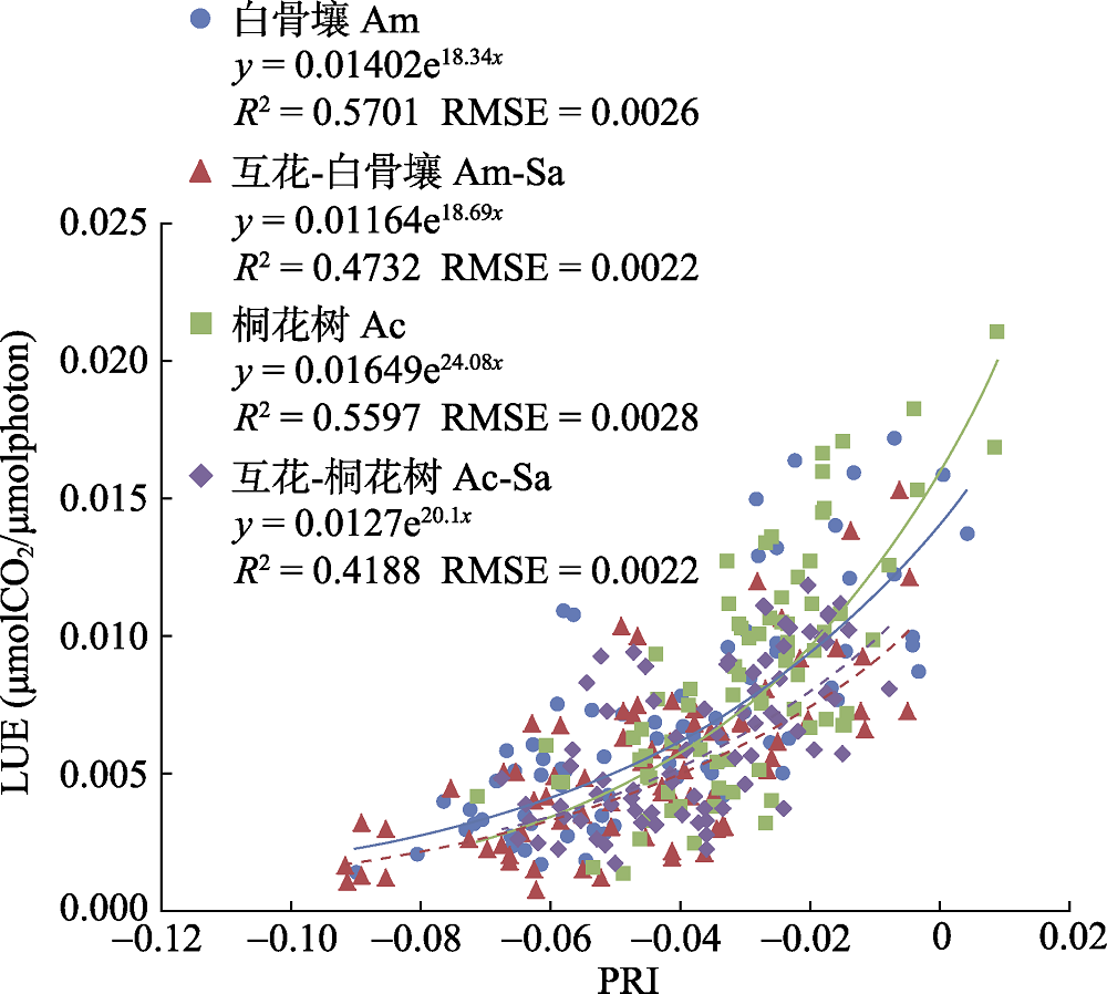
图1 白骨壤、互花米草影响下的白骨壤(简称互花-白骨壤)、桐花树、互花米草影响下的桐花树(互花-桐花树)等4种研究对象的光化学发射指数(PRI)与光能利用率(LUE)关系(引自Yang et al, 2018)
Fig. 1 LUE-PRI relationship of the four types of mangrove trees, i.e. Avicennia marina (Am), Avicennia marina affected by Spartina alterniflora (Am-Sa), Aegiceras corniculatum (Ac), Aegiceras corniculatum affected by Spartina alterniflora (Ac-Sa). Adopted from Yang et al (2018).
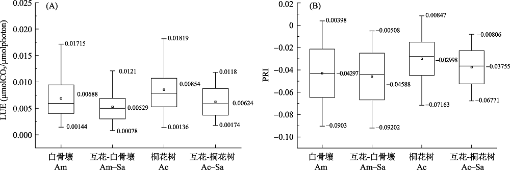
图2 4种类型红树林的光能利用率(LUE) (A)与光化学发射指数(PRI) (B)
Fig. 2 The light use efficiency (LUE) (A) and photochemical reflectance index (PRI) (B) of four types of mangrove trees. Am, Avicennia marina; Sa, Spartina alterniflora; Ac, Aegiceras corniculatum; Am-Sa, Avicennia marina affected by Spartina alterniflora; Ac-Sa, Aegiceras corniculatum affected by Spartina alterniflora.
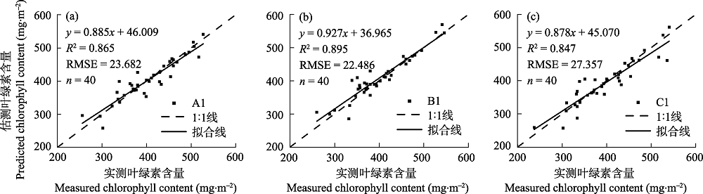
图3 分别利用数据集A、B和C构建的PLSR模型的独立验证图。实线表示拟合线, 虚线表示1:1线
Fig. 3 Independence verification of PLSR based on dataset a, b and c. The solid line represents the regression line, and the broken black line represents the 1:1 line.
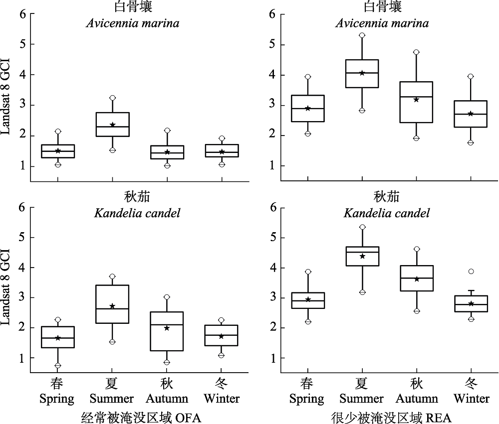
图4 基于种类和季节的不同淹没状况的绿色叶绿素指数(GCI)分布箱体图。每个箱体包含第一四分位数到第三四分位数; 箱体中的粗线表示中位数, 星点表示平均值, 而空白点表示异常值。
Fig. 4 Green chlorophyll index (GCI) distribution of the submerged level based on two mangrove species for four seasons. Each box embodies the first as well as the third quartile, and whiskers are located at 1.5 times the interquartile range. The bold line represents the median in the middle of the box. OFA, Often flooded area; RFA, Rare flooded area.
| [1] | Anderson K, Gaston KJ (2013) Lightweight unmanned aerial vehicles will revolutionize spatial ecology. Frontiers in Ecology and the Environment, 11, 138-146. |
| [2] | Berni JAJ, Zarco-Tejada PJ, Suarez L, Fereres E (2009) Thermal and narrowband multispectral remote sensing for vegetation monitoring from an unmanned aerial vehicle. IEEE Geoscience and Remote Sensing Society, 47, 722-738. |
| [3] | Bhardwaj A, Sam L, Akanksha, Martín-Torres FJ, kumer R (2016) UAVs as remote sensing platform in glaciology: Present applications and future prospects. Remote Sensing of Environment, 175, 196-204. |
| [4] | Blasco F, Aizpuru M, Gers C (2001) Depletion of the mangroves of Continental Asia. Wetlands Ecology and Management, 9, 255-266. |
| [5] | Candiago S, Remondino F, Giglio MD, Dubbini M, Gattelli M (2015) Evaluating multispectral images and vegetation indices for precision farming applications from UAV images. Remote Sensing, 7, 4026-4047. |
| [6] | Chen J, Tang YH, Chen XH, Yang W (2008) The review of estimating light use efficiency through photochemical reflectance index (PRI). International Journal of Remote Sensing, 12, 331-337. (in Chinese with English abstract) |
| [陈晋, 唐艳鸿, 陈学泓, 杨伟 (2008) 利用光化学反射植被指数估算光能利用率研究的进展. 遥感学报, 12, 331-337.] | |
| [7] | Chen LZ, Wang WQ, Lin P (2005) Photosynthetic and physiological responses of Kandelia candel L. Druce seedlings to duration of tidal immersion in artificial seawater. Environmental and Experimental Botany, 54, 256-266. |
| [8] | Claudia K, Andrea B, Steffen G, Tuan Vo Q, Stefan D (2011) Remote sensing of mangrove ecosystems: A review. Remote Sensing, 3, 878-928. |
| [9] | Conchedda G, Durieux L, Mayaux P (2008) An object-based method for mapping and change analysis in mangrove ecosystems. ISPRS Journal of Photogrammetry and Remote Sensing, 63, 578-589. |
| [10] | Córcoles JI, Ortega JF, Hernández D, Moreno MA (2013) Estimation of leaf area index in onion (Allium cepa L.) using an unmanned aerial vehicle. Biosystems Engineering, 115, 31-42. |
| [11] | Danson FM, Hetherington D, Morsdorf F, Koetz B, Allgower B (2007) Forest canopy gap fraction from terrestrial laser scanning. IEEE Geoscience and Remote Sensing Letters, 4, 157-160. |
| [12] | Deng GF (2002) Application of remote sensing technology in the investigation of mangrove resources. Central South Forestry Inventory and Planning, 21(1), 27-28. (in Chinese) |
| [邓国芳 (2002) 遥感技术在红树林资源调查中的应用. 中南林业调查规划, 21(1), 27-28.] | |
| [13] | Dronova I (2015) Object-based image analysis in wetland research: A review. Remote Sensing, 7, 6380-6413. |
| [14] | Duke NC, Meynecke JO, Dittmann, S, Ellison AM, Anger K, Berger U, Cannicci S, Diele K, Ewel KC, Field CD, Koedam N, Lee SY, Marchand N, Lee SY, Marchand C, Nordhaus I, Dahdouh-Guebas F (2007) A world without mangroves? Science, 317, 41. |
| [15] | Fan HQ, Liang SC (1995) Mangrove Research and Management in China. Science Press, Beijing. (in Chinese) |
| [范航清, 梁士楚 (1995) 中国红树林研究与管理. 科学出版社, 北京.] | |
| [16] | Franklin SE, Wulder MA, Gerylo GR (2001) Texture analysis of IKONOS panchromatic data for Douglas-fir forest age class separability in British Columbia. International Journal of Remote Sensing, 22, 2627-2632. |
| [17] | Fréchette E, Chang CY, Ensminger I (2016) Photoperiod and temperature constraints on the relationship between the photochemical reflectance index and the light use efficiency of photosynthesis in Pinus strobus. Tree Physiology, 36, 311. |
| [18] | Gamon JA (2015) Optical sampling of the flux tower footprint. Biogeosciences Discussions, 12, 4973-5014. |
| [19] | Gamon JA, Field CB, Bilger W, Björkman O, Fredeen A, Peñuelas J (1990) Remote sensing of the xanthophyll cycle and chlorophyll fluorescence in sunflower leaves and canopies. Oecologia, 85, 1-7. |
| [20] | Gamon JA, Peñuelas J, Field CB (1992) A narrow-waveband spectral index that tracks diurnal changes in photosynthetic efficiency. Remote Sensing of Environment, 41, 35-44. |
| [21] | Gao J (1998) A hybrid method toward accurate mapping of mangroves in a marginal habitat from SPOT multispectral data. International Journal of Remote Sensing, 19, 1887-1899. |
| [22] | Gao J (1999) A comparative study on spatial and spectral resolutions of satellite data in mapping mangrove forests. International Journal of Remote Sensing, 20, 2823-2833. |
| [23] | Garbulsky MF, Peñuelas J, Gamon J, Inoue Y, Filella I (2011) The photochemical reflectance index (PRI) and the remote sensing of leaf, canopy and ecosystem radiation use efficiencies: A review and meta-analysis. Remote Sensing of Environment, 115, 281-297. |
| [24] | Giri C (2016) Observation and monitoring of mangrove forests using remote sensing: Opportunities and challenges. Remote Sensing, 8, 783. |
| [25] | Gitelson AA, Viña A, Ciganda V, Rundqist DC, Arkebauer TJ (2005) Remote estimation of canopy chlorophyll content in crops. Geophysical Research Letters, 32, 93-114. |
| [26] | Greaves HE, Vierling LA, Eitel JUH, Boelman NT, Magney TS, Prager CM, Griffin KL (2015) Estimating aboveground biomass and leaf area of low-stature Arctic shrubs with terrestrial LiDAR. Remote Sensing of Environment, 164, 26-35. |
| [27] | Green EP, Clark CD, Mumby PJ, Edwards AJ, Ellis AC (1998) Remote sensing techniques for mangrove mapping. International Journal of Remote Sensing, 5, 935-956. |
| [28] | Guo M, Li J, Sheng C, Xu J, Wu L (2017) A review of wetland remote sensing. Sensors, 17, 777. |
| [29] | Hardin P, Jensen R (2011) Small-scale unmanned aerial vehicles in environmental remote sensing: Challenges and opportunities. Mapping Sciences & Remote Sensing, 48, 99-111. |
| [30] | He B, Lai T, Fan H, Wang W, Zheng H (2007) Comparison of flooding-tolerance in four mangrove species in a diurnal tidal zone in the Beibu Gulf. Estuarine, Coastal and Shelf Science, 74, 254-262. |
| [31] | Heenkenda MK, Joyce KE, Maier SW, Bruin SD (2015) Quantifying mangrove chlorophyll from high spatial resolution imagery. ISPRS Journal of Photogrammetry and Remote Sensing, 108, 234-244. |
| [32] | Heumann BW (2011) Satellite remote sensing of mangrove forests: Recent advances and future opportunities. Progress in Physical Geography, 35, 87-108. |
| [33] | Hosoi F, Omasa K (2006) Voxel-based 3-D modeling of individual trees for estimating leaf area density using high-resolution portable scanning lidar. IEEE Transactions on Geoscience and Remote Sensing, 44, 3610-3618. |
| [34] | Huang GL (1996) Conservation and development of mangrove wetlands in China. Forestry Resource Management, (5), 14-17. (in Chinese) |
| [黄桂林 (1996) 中国红树林湿地的保护与发展. 林业资源管理, (5), 14-17.] | |
| [35] | Jia M, Liu M, Wang Z, Mao D, Ren C, Cui H (2016) Evaluating the effectiveness of conservation on mangroves: A remote sensing-based comparison for two adjacent protected areas in Shenzhen and Hong Kong, China. Remote Sensing, 8, 627. |
| [36] | Jia M, Wang Z, Li L, Song K, Ren C, Liu B, Mao D (2014a) Mapping China’s mangroves based on an object-oriented classification of Landsat Imagery. Wetlands, 34, 277-283. |
| [37] | Jia M, Wang Z, Zhang Y, Ren C, Song K (2014b) Landsat-based estimation of mangrove forest loss and restoration in Guangxi Province, China, influenced by human and natural factors. IEEE Journal of Selected Topics in Applied Earth Observations and Remote Sensing, 8, 311-323. |
| [38] | Jia MM (2014) Remote Sensing Analysis of Dynamic Changes of Chinese Mangrove Forest from 1973 to 2013. PhD dissertation, Northeast Institute of Geography and Agricultural Ecology, Chinese Academy of Sciences. (in Chinese with English abstract) |
| [贾明明 (2014) 1973-2013年中国红树林动态变化遥感分析. 博士学位论文, 中国科学院东北地理与农业生态研究所, 长春.] | |
| [39] | Kalisperakis I, Stentoumis C, Grammatikopoulos L, Karantzalos K (2015) Leaf area index estimation in vineyards from UAV hyperspectral data, 2D image mosaics and 3D canopy surface models. International Society for Photogrammetry and Remote Sensing, XL-1/W4, pp. 299-303. |
| [40] | Kovacs JM, Flores-Verdugo F, Wang J, Aspden LP (2004) Estimating leaf area index of a degraded mangrove forest using high spatial resolution satellite data. Aquatic Botany, 80, 13-22. |
| [41] | Lelong CCD, Burger P, Jubelin G, Roux B, Labbé S, Baret F (2008) Assessment of unmanned aerial vehicles imagery for quantitative monitoring of wheat crop in small plots. Sensors, 8, 3557-3585. |
| [42] | Li CG (2002) Review on mangrove mapping based on remote sensing. Central South Forestry inventory and Planning,21, (4), 52-58. (in Chinese with English abstract) |
| [李春干 (2002) 红树林遥感成图研究综述. 中南林业调查规划, 21(4), 52-58.] | |
| [43] | Li CG (2013) Mangrove Remote Sensing Information Extraction and Spatial Evolution Mechanism. Science Press, Beijing. (in Chinese) |
| [李春干 (2013) 红树林遥感信息提取与空间演变机理研究. 科学出版社, 北京.] | |
| [44] | Li W, Cui LJ, Zhang MY, Wang YF (2008) A review of monitoring mangrove forest using 3S technologies in China. Wetland Science and Management, 4(2), 60-64. (in Chinese with English abstract) |
| [李伟, 崔丽娟, 张曼胤, 王义飞 (2008) 基于3S技术的中国红树林湿地监测研究概述. 湿地科学与管理, 4(2), 60-64.] | |
| [45] | Li Y, Guo Q, Su Y, Tao S, Zhao K, Xu G (2017) Retrieving the gap fraction, element clumping index, and leaf area index of individual trees using single-scan data from a terrestrial laser scanner. ISPRS Journal of Photogrammetry and Remote Sensing, 130, 308-316. |
| [46] | Lichtenthaler HK, Buschmann C (1987) Chlorophyll fluorescence spectra of green bean leaves. Journal of Plant Physiology, 129, 137-147. |
| [47] | Lin P (1997) Mangrove Ecosystem in China. Science Press, Beijing. (in Chinese) |
| [林鹏 (1997)中国红树林生态系. 科学出版社, 北京.] | |
| [48] | Lin P (2003) The characteristics of mangrove wetlands and some ecological engineering questions in China. Engineering Science, 5(6), 33-38. (in Chinese) |
| [林鹏 (2003) 中国红树林湿地与生态工程的几个问题. 中国工程科学, 5(6), 33-38.] | |
| [49] | Liu K, Li X, Shi X, Wang S (2008) Monitoring mangrove forest changes using remote sensing and GIS data with decision-tree learning. Wetlands, 28, 336. |
| [50] | Lorenzo R, DeJesus BR, Jara RB (1979) Assessment of mangrove forest deterioration in Zamboanga Peninsula, Philippines, using Landsat MSS data. Thirteenth International Symposium on Remote Sensing of Environment, 106(11), 166A-167A. |
| [51] | Lu JJ (1996) Classification of coastal wetlands in China. Environmental Report, (1), 1-2. (in Chinese) |
| [陆健健 (1996) 中国滨海湿地的分类. 环境导报, (1), 1-2.] | |
| [52] | Ma L, Cheng L, Han W, Zhong L, Li M (2014) Cultivated land information extraction from high-resolution unmanned aerial vehicle imagery data. Journal of Applied Remote Sensing, 8, 1-25. |
| [53] | Mumby PJ, Edwards AJ (2003) Mapping marine environments with IKONOS imagery: Enhanced spatial resolution can deliver greater thematic accuracy. Remote Sensing of Environment, 82, 248-257. |
| [54] | Nichol CJ, Rasche U, Matsubara S, Osmond B (2006) Assessing photosynthetic efficiency in an experimental mangrove canopy using remote sensing and chlorophyll fluorescence. Trees, 20, 9-15. |
| [55] | Olsoy PJ, Mitchell JJ, Levia DF, Clark PE, Glenn NF (2016) Estimation of big sagebrush leaf area index with terrestrial laser scanning. Ecological Indicators, 61, 815-821. |
| [56] | Pastorguzman J, Atkinson P, Dash J, Riojanieto R (2015) Spatiotemporal variation in mangrove chlorophyll concentration using Landsat 8. Remote Sensing, 7, 14530-14558. |
| [57] | Rasolofoharinoro M, Blasco F, Bellan MF, Aizpuru M, Gauquelin T, Denis J (1998) A remote sensing-based methodology for mangrove studies in Madagascar. International Journal of Remote Sensing, 19, 1873-1886. |
| [58] | Satyanarayana B, Muslim AM, Izzaty Horsali NA, Mat Zauki NA, Otero V, Nadzri MI, Ibrahim S, Husain ML, Dahdouh-Guebas F (2018) Status of the undisturbed mangroves at Brunei Bay, East Malaysia: A preliminary assessment based on remote sensing and ground-truth observations. PeerJ, 6, e4397. |
| [59] | Schlemmer M, Gitelson A, Schepers J, Ferguson R, Peng Y, Shanahan J, Rundquist D (2013) Remote estimation of nitrogen and chlorophyll contents in maize at leaf and canopy levels. International Journal of Applied Earth Observation and Geoinformation, 25, 47-54. |
| [60] | Seto KC, Fragkias M (2007) Mangrove conversion and aquaculture development in Vietnam: A remote sensing-based approach for evaluating the Ramsar Convention on Wetlands. Global Environmental Change, 17, 486-500. |
| [61] | Song C (2013) Optical remote sensing of forest leaf area index and biomass. Progress in Physical Geography, 37, 98-113. |
| [62] | Song C, White BL, Heumann BW (2011) Hyperspectral remote sensing of salinity stress on red (Rhizophora mangle) and white (Laguncularia racemosa) mangroves on Galapagos Islands. Remote Sensing Letters, 2, 221-230. |
| [63] | Spalding MD, Kainuma M, Collins L (2010) World atlas of mangroves. Earthscan, 90, 304. |
| [64] | Sun YG, Zhao DZ, Guo WY, Gao Y, Su X, Wei BQ (2013) A review on the application of remote sensing in mangrove ecosystem monitoring. Acta Ecologica Sinica, 33, 4523-4538. (in Chinese with English abstract) 33, 4523-4538. |
| [孙永光, 赵冬至, 郭文永, 高阳, 苏岫, 卫宝泉 (2013) 红树林生态系统遥感监测研究进展. 生态学报, 33, 4523-4538.] | |
| [65] | Tian J, Li X, Duan F, Wang J, Qu Y (2016) An efficient Seam elimination method for UAV images based on Wallis Dodging and Gaussian distance weight enhancement. Sensors, 16, 662. |
| [66] | Tian J, Wang L, Li X, Gong H, Shi C, Zhong R, Liu X (2017b) Comparison of UAV and WorldView-2 imagery for mapping leaf area index of mangrove forest. International Journal of Applied Earth Observation and Geoinformation, 61, 22-31. |
| [67] | Tian J, Wang L, Li X, Shi C, Gong H (2017a) Differentiating tree and shrub LAI in a mixed forest with ICESat/GLAS spaceborne LiDAR. IEEE Journal of Selected Topics in Applied Earth Observations and Remote Sensing, 10, 87-94. |
| [68] | Tian JY, Duan FZ, Wang L, Li XJ, Qu XY (2014) Elimination of image mosaic joints of UAV based on Wallis and distance weight enhancement. Chinese Journal of Image and Graphics, 19, 806-812. (in Chinese with English abstract) |
| [田金炎, 段福洲, 王乐, 李小娟, 屈新原 (2014) 基于Wallis与距离权重增强的无人机影像拼接缝消除. 中国图像图形学报, 19, 806-812.] | |
| [69] | Tian JY, Duan FZ, Yuan Y, Qu XY, Gao ML (2013) UAV flight quality assessment method based on image matching. Science of Surveying and Mapping, 38(5), 175-177. (in Chinese) |
| [田金炎, 段福洲, 袁媛, 屈新原, 高明亮 (2013) 基于图像匹配的无人机飞行质量评估方法. 测绘科学, 38(5), 175-177.] | |
| [70] | Turner DP, Urbanski S, Bremer D, Wofsy SC, Meyers T, Gower ST, Matthew G (2003) A cross biome comparison of daily light use efficiency for gross primary production. Global Change Biology, 9, 383-395. |
| [71] | Valiela I, Bowen JL, York JK (2001) Mangrove forests: One of the world’s threatened major tropical environments. BioScience, 51, 807-815. |
| [72] | Van der Zande D, Hoet W, Jonckheere I, Aardt JV, Coppin P (2006) Influence of measurement set-up of ground-based LiDAR for derivation of tree structure. Agricultural and Forest Meteorology, 141, 147-160. |
| [73] | Venkataratnam L, Thammappa SS, Ravisankar T, SaifuddinAnis (1997) Mapping and monitoring Prawn farming areas through remote sensing techniques. Geocarto International, 12, 23-29. |
| [74] | Verger A, Vigneau N, Chéron C, Gilliol JM, Comar A, Baret F (2014) Green area index from an unmanned aerial system over wheat and rapeseed crops. Remote Sensing of Environment, 152, 654-664. |
| [75] | Wang T, Zhang H, Lin H, Fang C (2015) Textural-spectral feature-based species classification of mangroves in Mai Po Nature Reserve from Worldview-3 imagery. Remote Sensing, 8, 24. |
| [76] | Wang L, Sousa WP (2009) Distinguishing mangrove species with laboratory measurements of hyperspectral leaf reflectance. International Journal of Remote Sensing, 30, 1267-1281. |
| [77] | Wang L, Sousa WP, Gong P (2004a) Integration of object-based and pixel-based classification for mapping mangroves with IKONOS imagery. International Journal of Remote Sensing, 25, 5655-5668. |
| [78] | Wang L, Sousa WP, Gong P, Biging GS (2004b) Comparison of IKONOS and QuickBird images for mapping mangrove species on the Caribbean coast of Panama. Remote Sensing of Environment, 91, 432-440. |
| [79] | Wang Y, Zuo P, Huang ZQ, Zou XQ (2006) Research and analysis the changes of mangrove wetland areas and reasons in Dong Zhaigang. Sichuan Environment, 25, 44-50. (in Chinese with English abstract) |
| [王胤, 左平, 黄仲琪, 邹欣庆 (2006) 海南东寨港红树林湿地面积变化及其驱动力分析. 四川环境, 25, 44-50.] | |
| [80] | Weng JH, Jhaung LH, Jiang JY, Lai GM, Liao TS (2006) Down-regulation of photosystem 2 efficiency and spectral reflectance in mango leaves under very low irradiance and varied chilling treatments. Photosynthetica, 44, 248-254. |
| [81] | Yang SS, Wang L, Chen S, Lu Y (2018) Evaluating the relationship between the photochemical reflectance index and light use efficiency in a mangrove forest with Spartina alterniflora invasion. International Journal of Applied Earth Observations and Geoinformation, 73, 778-785. |
| [82] | Ye Y, Tam NFY, Wong YS, Lu CY. (2003) Growth and physiological responses of two mangrove species (Bruguiera gymnorrhiza and Kandelia candel) to waterlogging. Environmental and Experimental Botany, 49, 209-221. |
| [83] | Zhang Q (2016) Correlation Between Photochemical Reflectance Index and Canopy Light Energy Utilization Based on Multi-angle Spectral Data. PhD dissertation, Nanjing University, Nanjing. (in Chinese with English abstract) |
| [张乾 (2016) 基于多角度光谱数据光化学反射指数与冠层光能利用率关系的构建. 博士学位论文, 南京大学, 南京.] | |
| [84] | Zhao HT, Wang LR (2000) Classification of the coastal wetland in China. Marine Science Bulletin, 19(6), 72-82. (in Chinese with English abstract) |
| [赵焕庭, 王丽荣 (2000) 中国海岸湿地的类型. 海洋通报, 19(6), 72-82.] | |
| [85] | Zhao K, García M, Liu S, Guo Q, Chen G, Zhang X, Zhou Y, Meng X (2015) Terrestrial lidar remote sensing of forests: Maximum likelihood estimates of canopy profile, leaf area index, and leaf angle distribution. Agricultural and Forest Meteorology, 209/210, 100-113. |
| [86] | Zheng G, Moskal LM (2012a) Computational-geometry-based retrieval of effective leaf area index using terrestrial laser scanning. IEEE Transactions on Geoscience and Remote Sensing, 50, 3958-3969. |
| [87] | Zheng G, Moskal LM (2012b) Spatial variability of terrestrial laser scanning based leaf area index. International Journal of Applied Earth Observation and Geoinformation, 19, 226-237. |
| [88] | Zheng G, Moskal LM, Kim SH (2013) Retrieval of effective leaf area index in heterogeneous forests with terrestrial laser scanning. IEEE Transactions on Geoscience and Remote Sensing, 51, 777-786. |
| [89] | Zhu YJ, Guo JL, Wu GJ, Guo ZH (2012) Application of high resolution satellite remote sensing in monitoring mangrove resource. World Forestry Research, 25, 39-44. (in Chinese with English abstract) |
| [朱耀军, 郭菊兰, 武高洁, 郭志华 (2012) 高分辨率卫星遥感在红树林资源监测中的应用. 世界林业研究, 25, 39-44.] |
| [1] | 梁竣策, 李开枝, 谭烨辉. 南海翼足类物种多样性与分布[J]. 生物多样性, 2026, 34(5): 25487-. |
| [2] | 周丽洁, 郝珉辉, 何怀江, 程艳霞, 张春雨, 赵秀海. 小兴安岭森林β多样性格局、组分及其影响因素[J]. 生物多样性, 2026, 34(4): 25443-. |
| [3] | 彭昀月, 彭奎, 刘昕然, 孙天怡, 张小全. 生物多样性信用的企业参与途径、市场发展障碍与建议[J]. 生物多样性, 2026, 34(4): 26031-. |
| [4] | 李伯尧, 盛天成, 幸小云. 生物多样性风险对企业财务绩效的影响: 来自中国上市公司的证据[J]. 生物多样性, 2026, 34(4): 25330-. |
| [5] | 刘昊, 张玉霄, 刘冰, 李飞飞, 马洪峥, 覃海宁, 李德铢, 陈文俐. 中国禾本科植物多样性及其物种名录[J]. 生物多样性, 2026, 34(4): 25438-. |
| [6] | 孔孜亦, 王德港, 王建涛, 裴志永, 孙晶, 张长春, 张军国. 基于SCD-HRNet模型的野生动物姿态估计及其在生物多样性监测中的应用: 以内蒙古赛罕乌拉地区为例[J]. 生物多样性, 2026, 34(4): 25287-. |
| [7] | 朱浩友, 周友兵, 罗怡, 周昭敏. 南充市城区繁殖鸟类群落20年前后的变化[J]. 生物多样性, 2026, 34(3): 24560-. |
| [8] | 侯姝彧, 刘盈盈, 杨锐. 《昆蒙框架》背景下国际OECMs体系构建实践进展及中国化思路[J]. 生物多样性, 2026, 34(3): 25264-. |
| [9] | 程晓帆, 李青媛, 李媛辉, 张明祥. 外来入侵物种治理政策体系的困境与出路[J]. 生物多样性, 2026, 34(2): 25332-. |
| [10] | 陈璐露, 汤皓婷, 冷红, 袁青, 杨昕悦. 城市街区建成环境对生物多样性的影响[J]. 生物多样性, 2026, 34(2): 25286-. |
| [11] | 高雯琪, 向景荣, 赵耀, 范灵霜, 谷圆, 邵韦涵, 李高俊, 赵光军, 陈明斌, 蔡杏伟, 陈凯. 海南热带雨林国家公园黎母山和尖峰岭溪流鱼类群落特征及其对土地利用的响应[J]. 生物多样性, 2026, 34(2): 25374-. |
| [12] | 卢晓强, 芮丹, 张江峰, 尹冰鑫, 王雨露, 岑雨婷, 崔怡晨, 杨万霞. 氮输入驱动的关键生态过程对生物多样性的影响及其管理启示[J]. 生物多样性, 2026, 34(2): 25368-. |
| [13] | 谭廷鸿, 高帆, 杨雨, 肖群英, 吴春芳, 邱娜, 赵宁宁, 周敏, 康公平, 卢志宏, 高健强, 杨红, 杨传东, 邓春英. 中国西南喀斯特地区大型真菌物种编目[J]. 生物多样性, 2026, 34(2): 25281-. |
| [14] | 章旭日, 罗标, 赵彤, 黄丹, 艾为明. 浙江鱼类多样性: 编目、分布与保护[J]. 生物多样性, 2026, 34(2): 25225-. |
| [15] | 刘海鸥, 郝志明, 杜乐山, 刘文慧, 李子圆, 刘蕾. 全球生物多样性框架基金运行进展、挑战与启示[J]. 生物多样性, 2026, 34(2): 25463-. |
| 阅读次数 | ||||||
|
全文 |
|
|||||
|
摘要 |
|
|||||
备案号:京ICP备16067583号-7
Copyright © 2026 版权所有 《生物多样性》编辑部
地址: 北京香山南辛村20号, 邮编:100093
电话: 010-62836137, 62836665 E-mail: biodiversity@ibcas.ac.cn
![]()