
Biodiv Sci ›› 2024, Vol. 32 ›› Issue (3): 23381. DOI: 10.17520/biods.2023381 cstr: 32101.14.biods.2023381
• Technology and Methodologies • Previous Articles Next Articles
Fengming Wan1,2, Huawei Wan2,*( ), Zhiru Zhang2, Jixi Gao2,*(), Chenxi Sun2, Yongcai Wang3
Received:2023-10-13
Accepted:2023-12-25
Online:2024-03-20
Published:2024-03-06
Contact:
*E-mail: livelyhw@163.com;
gjx@nies.org
Fengming Wan, Huawei Wan, Zhiru Zhang, Jixi Gao, Chenxi Sun, Yongcai Wang. The application potential of unmanned aerial vehicle surveys in grassland plant diversity[J]. Biodiv Sci, 2024, 32(3): 23381.
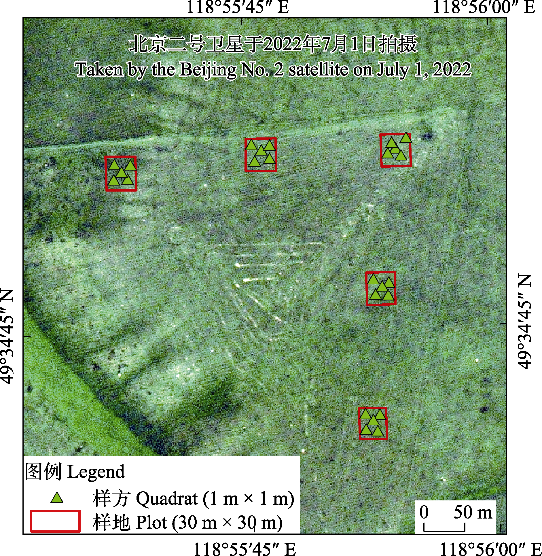
Fig. 1 The location of the study area and the distribution of the quadrats
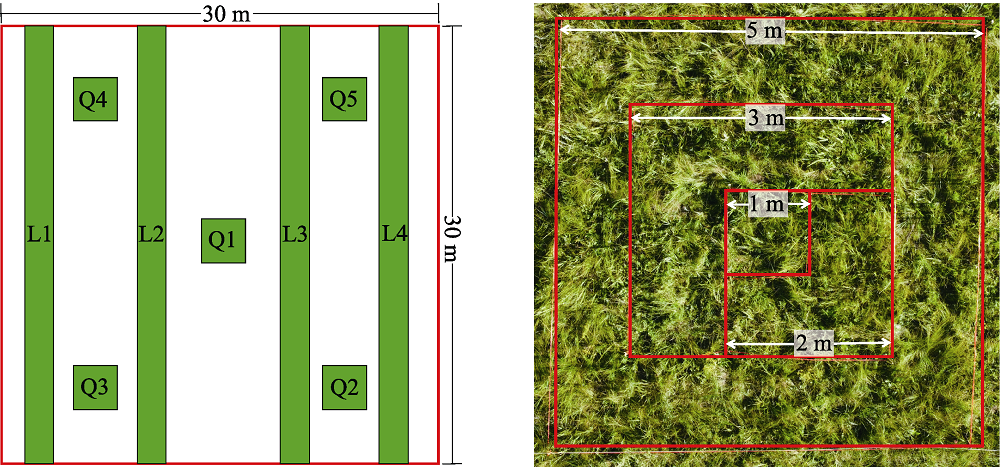
Fig. 2 Relative position of the quadrat and the line transect (a) and the diagram of nested quadrat (b). Q, Quadrat, 1 m × 1 m; L, Line transect, 30 m × 1 m.
| 照片采集设备 Photo acquisition equipment | 采集对象 Sampling objects | 飞行高度 Flight height (m) | 拍摄角度 Angle of photography | 90°拍摄时空间分辨率 Vertical shooting spatial resolution (mm) | 备注 Remarks |
|---|---|---|---|---|---|
| DJI Mini 3 Pro | 30 m × 1 m样线 30 m × 1 m line transect | 1 | 30°、45°、60°、75°、90° | 0.43 | |
| 2 | 30°、45°、60°、75°、90° | 0.88 | |||
| DJI Mavic 2 Pro | 30 m × 1 m样线 30 m × 1 m line transect | 1.5 | 30°、45°、60°、75°、90° | 0.38 | |
| 3 | 30°、45°、60°、75°、90° | 0.77 | |||
| DJI Matrice 300 RTK + AQ600 | 1 m × 1 m样方 1 m × 1 m quadrat | 2 | 90° | 0.45 | |
| 3 | 90° | 0.65 | |||
| 4 | 90° | 0.90 | |||
| 5 | 90° | 1.10 | |||
| 6 | 90° | 1.35 | |||
| DJI Matrice 300 RTK + H20 | 30 m × 1 m样线 30 m × 1 m line transect | - | 45°、60°、75°、90° | 1.00 | 变焦相机, 固定分辨率拍摄 Zoom camera, fixed resolution shooting |
| - | 45°、60°、75°、90° | 2.00 | |||
| 5 | 90° | 0.20 |
Table 1 Unmanned aerial vehicle (UAV) aerial photography acquisition parameters
| 照片采集设备 Photo acquisition equipment | 采集对象 Sampling objects | 飞行高度 Flight height (m) | 拍摄角度 Angle of photography | 90°拍摄时空间分辨率 Vertical shooting spatial resolution (mm) | 备注 Remarks |
|---|---|---|---|---|---|
| DJI Mini 3 Pro | 30 m × 1 m样线 30 m × 1 m line transect | 1 | 30°、45°、60°、75°、90° | 0.43 | |
| 2 | 30°、45°、60°、75°、90° | 0.88 | |||
| DJI Mavic 2 Pro | 30 m × 1 m样线 30 m × 1 m line transect | 1.5 | 30°、45°、60°、75°、90° | 0.38 | |
| 3 | 30°、45°、60°、75°、90° | 0.77 | |||
| DJI Matrice 300 RTK + AQ600 | 1 m × 1 m样方 1 m × 1 m quadrat | 2 | 90° | 0.45 | |
| 3 | 90° | 0.65 | |||
| 4 | 90° | 0.90 | |||
| 5 | 90° | 1.10 | |||
| 6 | 90° | 1.35 | |||
| DJI Matrice 300 RTK + H20 | 30 m × 1 m样线 30 m × 1 m line transect | - | 45°、60°、75°、90° | 1.00 | 变焦相机, 固定分辨率拍摄 Zoom camera, fixed resolution shooting |
| - | 45°、60°、75°、90° | 2.00 | |||
| 5 | 90° | 0.20 |
| 调查方式 Survey method | 实际调查面积 Actual survey area (m2) | 调查代表的区域面积 The area represented by the survey (m2) | 物种数 No. of species |
|---|---|---|---|
| 嵌套样方 Nested quadrats | 1 | - | 19 |
| 4 | - | 26 | |
| 9 | - | 33 | |
| 25 | - | 39 | |
| 不同数量样方 Different number of quadrats | 1 | 900 | 20.8 |
| 3 | 900 | 33.6 | |
| 5 | 900 | 39.4 | |
| 不同数量样地 Different number of plots | 125 | 250,000 | 49.6 |
| 250 | 250,000 | 62.7 | |
| 375 | 250,000 | 69.3 | |
| 500 | 250,000 | 74.0 | |
| 625 | 250,000 | 77 | |
| 增加样线 Add line transects | 120 | 900 | 10.2 |
| 600 | 250,000 | 10 |
Table 2 No. of species investigated by different survey methods
| 调查方式 Survey method | 实际调查面积 Actual survey area (m2) | 调查代表的区域面积 The area represented by the survey (m2) | 物种数 No. of species |
|---|---|---|---|
| 嵌套样方 Nested quadrats | 1 | - | 19 |
| 4 | - | 26 | |
| 9 | - | 33 | |
| 25 | - | 39 | |
| 不同数量样方 Different number of quadrats | 1 | 900 | 20.8 |
| 3 | 900 | 33.6 | |
| 5 | 900 | 39.4 | |
| 不同数量样地 Different number of plots | 125 | 250,000 | 49.6 |
| 250 | 250,000 | 62.7 | |
| 375 | 250,000 | 69.3 | |
| 500 | 250,000 | 74.0 | |
| 625 | 250,000 | 77 | |
| 增加样线 Add line transects | 120 | 900 | 10.2 |
| 600 | 250,000 | 10 |
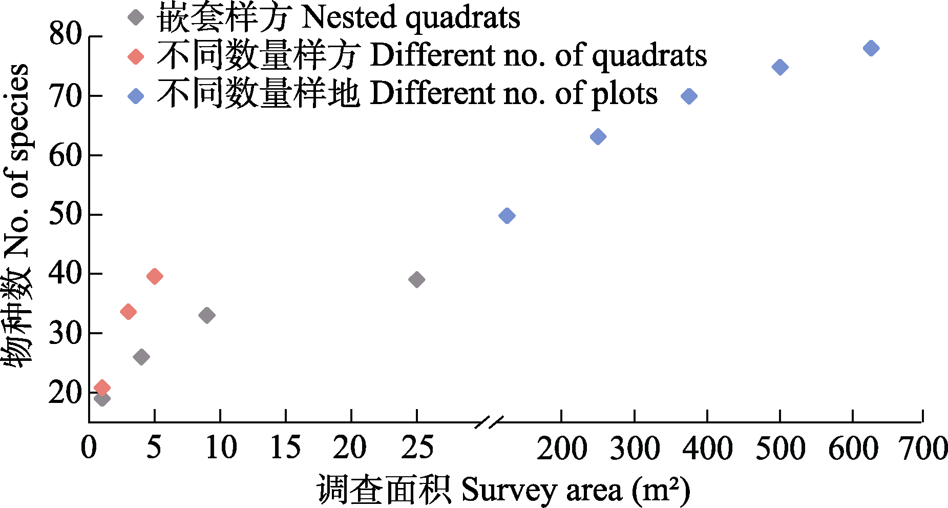
Fig. 3 Scatter plots of species investigated by different survey methods
| 飞行高度 Flight height | 拍摄角度 Angle of photography | ||||
|---|---|---|---|---|---|
| 30° | 45° | 60° | 75° | 90° | |
| 1 m |  |  |  |  |  |
| 2 m |  | 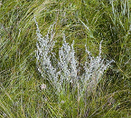 | 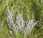 | 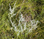 | 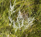 |
Table 3 Comparison of aerial images at different flight heights and angles
| 飞行高度 Flight height | 拍摄角度 Angle of photography | ||||
|---|---|---|---|---|---|
| 30° | 45° | 60° | 75° | 90° | |
| 1 m | | | | | |
| 2 m | | | | | |
| 飞行高度 Flight height (m) | |||||
|---|---|---|---|---|---|
| 2 | 3 | 4 | 5 | 6 | |
| 空间分辨率 Spatial resolution (mm) | 0.45 | 0.65 | 0.90 | 1.10 | 1.35 |
| 影像 Image | 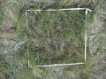 | 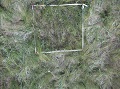 | 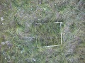 | 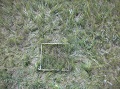 |  |
| 物种识别率 Species recognition rates (%) | 67.16 | 59.70 | 55.22 | 49.25 | 43.28 |
Table 4 Species recognition rates from unmanned aerial vehicle (UAV) images with different spatial resolutions
| 飞行高度 Flight height (m) | |||||
|---|---|---|---|---|---|
| 2 | 3 | 4 | 5 | 6 | |
| 空间分辨率 Spatial resolution (mm) | 0.45 | 0.65 | 0.90 | 1.10 | 1.35 |
| 影像 Image | | | | | |
| 物种识别率 Species recognition rates (%) | 67.16 | 59.70 | 55.22 | 49.25 | 43.28 |
| 调查方式 Survey method | 调查对象 Survey respondents | 调查用时 Time of survey (min) |
|---|---|---|
| 人工地面调查 Artificial ground survey | 1 m × 1 m 样方 1 m × 1 m quadrat | 10 |
| 2 m × 2 m 样方 2 m × 2 m quadrat | 18 | |
| 3 m × 3 m 样方 3 m × 3 m quadrat | 28.5 | |
| 5 m × 5 m 样方 5 m × 5 m quadrat | 46.5 | |
| 30 m × 1 m 样线 30 m × 1 m line transect | 10* | |
| 无人机调查 UAV survey | 1 m × 1 m 样方 1 m × 1 m quadrat | 0.28 |
| 30 m × 1 m 样线 30 m × 1 m line transect | 1.05 |
Table 5 Time of different survey methods
| 调查方式 Survey method | 调查对象 Survey respondents | 调查用时 Time of survey (min) |
|---|---|---|
| 人工地面调查 Artificial ground survey | 1 m × 1 m 样方 1 m × 1 m quadrat | 10 |
| 2 m × 2 m 样方 2 m × 2 m quadrat | 18 | |
| 3 m × 3 m 样方 3 m × 3 m quadrat | 28.5 | |
| 5 m × 5 m 样方 5 m × 5 m quadrat | 46.5 | |
| 30 m × 1 m 样线 30 m × 1 m line transect | 10* | |
| 无人机调查 UAV survey | 1 m × 1 m 样方 1 m × 1 m quadrat | 0.28 |
| 30 m × 1 m 样线 30 m × 1 m line transect | 1.05 |
| [1] | Abdel-Rahman E, Makori D, Landmann T, Piiroinen R, Gasim S, Pellikka P, Raina S (2015) The utility of AISA eagle hyperspectral data and random forest classifier for flower mapping. Remote Sensing, 7, 13298-13318. |
| [2] | Alvarez-Vanhard E, Houet T, Mony C, Lecoq L, Corpetti T (2020) Can UAVs fill the gap between in situ surveys and satellites for habitat mapping? Remote Sensing of Environment, 243, 111780. |
| [3] | Alves Oliveira R, Marcato J Jr, Soares Costa C, Näsi R, Koivumäki N, Niemeläinen O, Kaivosoja J, Nyholm L, Pistori H, Honkavaara E (2022) CNN based automated weed detection system using UAV imagery. Silage grass sward nitrogen concentration and dry matter yield estimation using deep regression and RGB images captured by UAV. Agronomy, 12, 1352. |
| [4] | Anul Haq M (2022) CNN based automated weed detection system using UAV imagery. Computer Systems Science and Engineering, 42, 837-849. |
| [5] | Delectis Florae Reipublicae Popularis Sinicae Agendae Academiae Sinicae Edita (1959-2004) Flora Reipublicae Popularis Sinicae (Tomus 1-80). Science Press, Beijing. (in Chinese) |
| [ 中国科学院中国植物志编辑委员会 (1959-2004) 中国植物志(第1-80卷). 科学出版社, 北京.] | |
| [6] |
Fang JY, Wang XP, Shen ZH, Tang ZY, He JS, Yu D, Jiang Y, Wang ZH, Zheng CY, Zhu JL, Guo ZD (2009) Methods and protocols for plant community inventory. Biodiversity Science, 17, 533-548. (in Chinese with English abstract)
DOI |
|
[ 方精云, 王襄平, 沈泽昊, 唐志尧, 贺金生, 于丹, 江源, 王志恒, 郑成洋, 朱江玲, 郭兆迪 (2009) 植物群落清查的主要内容、方法和技术规范. 生物多样性, 17, 533-548.]
DOI |
|
| [7] | Gallmann J, Schüpbach B, Jacot K, Albrecht M, Winizki J, Kirchgessner N, Aasen H (2022) Flower mapping in grasslands with drones and deep learning. Frontiers in Plant Science, 12, 774965. |
| [8] |
Gao JT, Sun FD, Huo F, Zhang LB, Zhou S, Yang TY, Bianbazhaxi (2021) Application and evaluation of unmanned aerial vehicle remote sensing in grassland animal and plant monitoring. Acta Agrestia Sinica, 29, 1-9. (in Chinese with English abstract)
DOI |
|
[ 高娟婷, 孙飞达, 霍霏, 张履冰, 周俗, 杨廷勇, 边巴扎西 (2021) 无人机遥感技术在草地动植物调查监测中的应用与评价. 草地学报, 29, 1-9.]
DOI |
|
| [9] | Gómez-Candón D, De Castro AI, López-Granados F (2014) Assessing the accuracy of mosaics from unmanned aerial vehicle (UAV) imagery for precision agriculture purposes in wheat. Precision Agriculture, 15, 44-56. |
| [10] |
Guo K, Liu CC, Pan QM (2016) Methods of observing typical plant communities in the Steppe and Desert Biodiversity Observation Network, Sino BON. Biodiversity Science, 24, 1220-1226. (in Chinese with English abstract)
DOI |
|
[ 郭柯, 刘长成, 潘庆民 (2016) 中国草原/荒漠植物多样性监测网模式植物群落监测方案. 生物多样性, 24, 1220-1226.]
DOI |
|
| [11] | Hautier Y, Isbell F, Borer ET, Seabloom EW, Harpole WS, Lind EM, MacDougall AS, Stevens CJ, Adler PB, Alberti J, Bakker JD, Brudvig LA, Buckley YM, Cadotte M, Caldeira MC, Chaneton EJ, Chu CJ, Daleo P, Dickman CR, Dwyer JM, Eskelinen A, Fay PA, Firn J, Hagenah N, Hillebrand H, Iribarne O, Kirkman KP, Knops JMH, La Pierre KJ, McCulley RL, Morgan JW, Pärtel M, Pascual J, Price JN, Prober SM, Risch AC, Sankaran M, Schuetz M, Standish RJ, Virtanen R, Wardle GM, Yahdjian L, Hector A (2018) Local loss and spatial homogenization of plant diversity reduce ecosystem multifunctionality. Nature Ecology & Evolution, 2, 50-56. |
| [12] | Hill DJ, Tarasoff C, Whitworth GE, Baron J, Bradshaw JL, Church JS (2016) Utility of unmanned aerial vehicles for mapping invasive plant species: A case study on yellow flag iris (Iris pseudacorus L.). International Journal of Remote Sensing, 38, 2083-2105. |
| [13] | Hung C, Xu Z, Sukkarieh S (2014) Feature learning based approach for weed classification using high resolution aerial images from a digital camera mounted on a UAV. Remote Sensing, 6, 12037-12054. |
| [14] | Jackson J, Lawson CS, Adelmant C, Huhtala E, Fernandes P, Hodgson R, King H, Williamson L, Maseyk K, Hawes N, Hector A, Salguero-Gómez R (2022) Short-range multispectral imaging is an inexpensive, fast, and accurate approach to estimate biodiversity in a temperate calcareous grassland. Ecology and Evolution, 12, e9623. |
| [15] | Jin XL, Liu SY, Baret F, Hemerlé M, Comar A (2017) Estimates of plant density of wheat crops at emergence from very low altitude UAV imagery. Remote Sensing of Environment, 198, 105-114. |
| [16] |
Kattenborn T, Eichel J, Fassnacht FE (2019) Convolutional neural networks enable efficient, accurate and fine-grained segmentation of plant species and communities from high-resolution UAV imagery. Scientific Reports, 9, 17656.
DOI PMID |
| [17] | Landmann T, Piiroinen R, Makori DM, Abdel-Rahman EM, Makau S, Pellikka P, Raina SK (2015) Application of hyperspectral remote sensing for flower mapping in African savannas. Remote Sensing of Environment, 166, 50-60. |
| [18] | López-Granados F, Torres-Sánchez J, De Castro AI, Serrano-Pérez A, Mesas-Carrascosa FJ, Peña JM (2016) Object-based early monitoring of a grass weed in a grass crop using high resolution UAV imagery. Agronomy for Sustainable Development, 36, 67. |
| [19] | Lyu X, Li XB, Dang DL, Dou HS, Wang K, Lou AR (2022) Unmanned aerial vehicle (UAV) remote sensing in grassland ecosystem monitoring: A systematic review. Remote Sensing, 14, 1096. |
| [20] | Mantyka-Pringle CS, Visconti P, Di Marco M, Martin TG, Rondinini C, Rhodes JR (2015) Climate change modifies risk of global biodiversity loss due to land-cover change. Biological Conservation, 187, 103-111. |
| [21] | Martin FM, Müllerová J, Borgniet L, Dommanget F, Breton V, Evette A (2018) Using single- and multi-date UAV and satellite imagery to accurately monitor invasive knotweed species. Remote Sensing, 10, 1662. |
| [22] |
Müllerová J, Brůna J, Bartaloš T, Dvořák P, Vítková M, Pyšek P (2017) Timing is important: Unmanned aircraft vs. satellite imagery in plant invasion monitoring. Frontiers in Plant Science, 8, 887.
DOI PMID |
| [23] | Polley H, Yang CH, Wilsey B, Fay P (2019) Spectral heterogeneity predicts local-scale gamma and beta diversity of mesic grasslands. Remote Sensing, 11, 458. |
| [24] | Qian DW, Du YG, Li Q, Guo XW, Fan B, Cao GM (2022) Impacts of alpine shrub-meadow degradation on its ecosystem services and spatial patterns in Qinghai-Tibetan Plateau. Ecological Indicators, 135, 108541. |
| [25] | Qin Y, Sun Y, Zhang W, Qin Y, Chen JJ, Wang ZW, Zhou ZY (2020) Species monitoring using unmanned aerial vehicle to reveal the ecological role of plateau pika in maintaining vegetation diversity on the Northeastern Qinghai-Tibetan Plateau. Remote Sensing, 12, 2480. |
| [26] | Rossi C, Kneubühler M, Schütz M, Schaepman ME, Haller RM, Risch AC, Disney M, He K (2022) Spatial resolution, spectral metrics and biomass are key aspects in estimating plant species richness from spectral diversity in species-rich grasslands. Remote Sensing in Ecology and Conservation, 8, 297-314. |
| [27] |
Sun Y, Qin Y, Wei TF, Chang L, Zhang RP, Liu ZY, Lyu YY, Yi SH (2022) Methods and development trend for the measurement of plant species diversity in grasslands. Chinese Journal of Applied Ecology, 33, 655-663. (in Chinese with English abstract)
DOI |
|
[ 孙义, 秦彧, 魏天锋, 常丽, 张仁平, 刘志有, 吕燕燕, 宜树华 (2022) 草地植物物种多样性测度方法及发展趋势. 应用生态学报, 33, 655-663.]
DOI |
|
| [28] | Sun Y, Yi SH, Hou FJ (2018) Unmanned aerial vehicle methods makes species composition monitoring easier in grasslands. Ecological Indicators, 95, 825-830. |
| [29] | Sun Y, Yuan YX, Luo Y, Ji WX, Bian QY, Zhu ZQ, Wang JR, Qin Y, He XZ, Li M, Yi SH (2022) An improved method for monitoring multiscale plant species diversity of alpine grassland using UAV: A case study in the source region of the Yellow River, China. Frontiers in Plant Science, 13, 905715. |
| [30] | Tang ZY, Qiao XJ, Fang JY (2009) Species-area relationship in biological communities. Biodiversity Science, 17, 549-559. (in Chinese with English abstract) |
|
[ 唐志尧, 乔秀娟, 方精云 (2009) 生物群落的种-面积关系. 生物多样性, 17, 549-559.]
DOI |
|
| [31] | Villoslada M, Bergamo TF, Ward RD, Burnside NG, Joyce CB, Bunce RGH, Sepp K (2020) Fine scale plant community assessment in coastal meadows using UAV based multispectral data. Ecological Indicators, 111, 105979. |
| [32] | Wei TF, Shangguan DH, Yi SH, Ding YJ (2021) Characteristics and controls of vegetation and diversity changes monitored with an unmanned aerial vehicle (UAV) in the foreland of the Urumqi Glacier No. 1, Tianshan, China. Science of the Total Environment, 771, 145433. |
| [33] | White TB, Viana LR, Campbell G, Elverum C, Bennun LA (2021) Using technology to improve the management of development impacts on biodiversity. Business Strategy and the Environment, 30, 3502-3516. |
| [34] | Wijesingha J, Astor T, Schulze-Brüninghoff D, Wachendorf M (2020) Mapping invasive Lupinus polyphyllus Lindl. in semi-natural grasslands using object-based image analysis of UAV-borne images. PFG-Journal of Photogrammetry, Remote Sensing and Geoinformation Science, 88, 391-406. |
| [35] | Zhang X, Bao YH, Wang DL, Xin XP, Ding L, Xu DW, Hou LL, Shen J (2021) Using UAV LiDAR to extract vegetation parameters of Inner Mongolian grassland. Remote Sensing, 13, 656. |
| [36] | Zhang XL, Dong SK, Guo XD, Han YH, Li HM, Feng J, Wang C, Liu QR (2015) Comparison of different sampling techniques for alpine grassland plant diversity on Qinghai-Tibet Plateau. Chinese Journal of Ecology, 34, 3568-3574. (in Chinese with English abstract) |
| [ 张晓蕾, 董世魁, 郭贤达, 韩雨晖, 李灏漫, 冯憬, 王琛, 刘全儒 (2015) 青藏高原高寒草地植物多样性调查方法的比较. 生态学杂志, 34, 3568-3574.] | |
| [37] | Zhao YJ, Sun YH, Chen WH, Zhao YP, Liu XL, Bai YF (2021) The potential of mapping grassland plant diversity with the links among spectral diversity, functional trait diversity, and species diversity. Remote Sensing, 13, 3034. |
| [38] | Zheng HB, Zhou X, He JY, Yao X, Cheng T, Zhu Y, Cao WX, Tian YC (2020) Early season detection of rice plants using RGB, NIR-G-B and multispectral images from unmanned aerial vehicle (UAV). Computers and Electronics in Agriculture, 169, 105223. |
| [1] | Yafei Shi, Furong Niu, Xiaomin Huang, Xing Hong, Xiangwen Gong, Yanli Wang, Dong Lin, Xiaoni Liu. Interpretable machine learning and its applications in ecology [J]. Biodiv Sci, 2026, 34(1): 25210-. |
| [2] | Shuai Li, Weihua Liu, Yudan Xu, Xiaobo Tian, Houjuan Song, Xiaoting Yue, Lingling Wu, Qing Zhang, Tieliang Shanguan. A dataset on inventory and geographical distributions of vascular plants in Shanxi, China [J]. Biodiv Sci, 2025, 33(7): 24317-. |
| [3] | Qinwen Lin, Na Zhang, Qiang Wang. A dataset on inventory and geographical distribution of halophytes of China [J]. Biodiv Sci, 2025, 33(7): 25030-. |
| [4] | Quanfeng Yang, Yanjie Tang, Haijun Xiao, Ying Wang, Rong Zhang, Fang Ouyang, Shuhua Wei. Cascading effects of plant diversity-grasshoppers-carabids and their impacts on primary productivity across grassland types of Ningxia, China [J]. Biodiv Sci, 2025, 33(6): 25021-. |
| [5] | Yuan Jingyi, Zhang Xu, Tian Zhenpeng, Wang Zizhe, Gao Yongping, Yao Dizhao, Guan Hongcan, Li Wenkai, Liu Jing, Zhang Hong, Ma Qin. A comparison of methods for extracting tree species composition and quantitative characteristics in urban plant communities using UAV high-resolution RGB imagery and LiDAR point cloud [J]. Biodiv Sci, 2025, 33(4): 24237-. |
| [6] | Song Wei, Cheng Cai, Wang Jiawei, Wu Jihua. Soil microbes regulate the relationships between plant diversity and ecosystem functions [J]. Biodiv Sci, 2025, 33(4): 24579-. |
| [7] | Zhang Haobin, Xiao Lu, Liu Yanjie. Effects of artificial light at night on the diversity and growth of invasive alien and native plants [J]. Biodiv Sci, 2025, 33(4): 24553-. |
| [8] | Xie Gan, Xuan Jing, Fu Qidi, Wei Ze, Xue Kai, Luo Hairui, Gao Jixi, Li Min. Establishing an intelligent identification model for unmanned aerial vehicle surveys of grassland plant diversity [J]. Biodiv Sci, 2025, 33(4): 24236-. |
| [9] | Weiyu Lu, Xu Chen, Riqian Zhang, Yunhai Zhang, Zhao Li. Effects of nitrogen and cow dung input on plant species-area relationship in a typical grassland [J]. Biodiv Sci, 2025, 33(12): 25251-. |
| [10] | Yixin Sun, Chunyu Hou, Lei Zhou, Xue Wei, Jinhao Ma, Juan Xue, Xiaohan Li, Pengfei Wu. Effects of annual and perennial potted legume forages on soil nematode communities in the Qinghai-Xizang Plateau [J]. Biodiv Sci, 2024, 32(7): 24040-. |
| [11] | Jianwei Cheng, Manhou Xu, Yongjing Dou, Yadong Wang, Yanan Wang, Xinmin Liu, Frank Yonghong Li. Seasonal dynamics of arthropod communities during horse dung decomposition in Inner Mongolian grasslands [J]. Biodiv Sci, 2024, 32(6): 24018-. |
| [12] | Jiali Lian, Jing Chen, Xueqin Yang, Ying Zhao, Xu Luo, Cui Han, Yaxin Zhao, Jianping Li. Responses of desert steppe plant diversity and microbial diversity to precipitation change [J]. Biodiv Sci, 2024, 32(6): 24044-. |
| [13] | Yongcai Wang, Huawei Wan, Jixi Gao, Zhuowei Hu, Chenxi Sun, Na Lü, Zhiru Zhang. Identification of common native grassland plants in northern China using deep learning [J]. Biodiv Sci, 2024, 32(4): 23435-. |
| [14] | Naipeng Zhang, Hongru Liang, Yan Zhang, Chao Sun, Yong Chen, Lulu Wang, Jiangbao Xia, FangLei Gao. Effects of soil type and groundwater depth on spatial differentiation of typical salt marsh plant communities in the Yellow River Delta [J]. Biodiv Sci, 2024, 32(2): 23370-. |
| [15] | Chen-Kun Jiang, Wen-Bin Yu, Guang-Yuan Rao, Huaicheng Li, Julien B. Bachelier, Hartmut H. Hilger, Theodor C. H. Cole. Plant Phylogeny Posters—An educational project on plant diversity from an evolutionary perspective [J]. Biodiv Sci, 2024, 32(11): 24210-. |
| Viewed | ||||||
|
Full text |
|
|||||
|
Abstract |
|
|||||
Copyright © 2026 Biodiversity Science
Editorial Office of Biodiversity Science, 20 Nanxincun, Xiangshan, Beijing 100093, China
Tel: 010-62836137, 62836665 E-mail: biodiversity@ibcas.ac.cn