
Biodiv Sci ›› 2021, Vol. 29 ›› Issue (8): 1097-1107. DOI: 10.17520/biods.2020229 cstr: 32101.14.biods.2020229
• Original Papers: Animal Diversity • Previous Articles Next Articles
Xing Ma1#, Hao Wang1#, Wei Yu3,1, Yong Du1, Jianchao Liang2,*( ), Huijian Hu2,*(), Shengrong Qiu4, Lu Liu4
Received:2021-02-07
Accepted:2021-04-15
Online:2021-08-20
Published:2021-06-12
Contact:
Jianchao Liang,Huijian Hu
About author:First author contact:# Co-first authors
Xing Ma, Hao Wang, Wei Yu, Yong Du, Jianchao Liang, Huijian Hu, Shengrong Qiu, Lu Liu. Analysis on the hotspot and conservation gaps of bird biodiversity in Guangdong Province based on MaxEnt model[J]. Biodiv Sci, 2021, 29(8): 1097-1107.
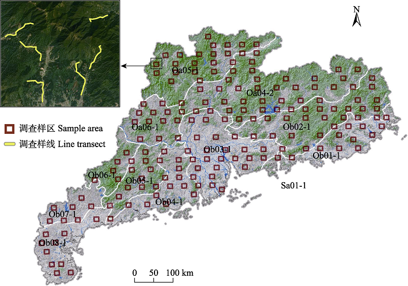
Fig. 1 Study area and the distribution of sample area and line transect
| 环境因子 Environmental factors | 缩写 Abbreviation | 单位 Unit |
|---|---|---|
| 高程 Altitude | ALT | m |
| 年均降水量 Annual precipitation | AP | mm |
| 年均温 Annual mean temperature | AMT | ℃ |
| 年均湿度 Annual mean humidity | AMH | % |
| 年均温度差 Annual average temperature difference | AMTD | ℃ |
| 土地利用类型 Land use | LU | / |
| 归一化植被指数 Normalized difference vegetation index | NDVI | / |
| 人口密度 Population density | PD | 人/km2 |
| 距离城镇距离 Distance from urban land | DUL | m |
| 距离水源距离 Distance from water | DW | m |
Table 1 Environmental factors used in species distribution models
| 环境因子 Environmental factors | 缩写 Abbreviation | 单位 Unit |
|---|---|---|
| 高程 Altitude | ALT | m |
| 年均降水量 Annual precipitation | AP | mm |
| 年均温 Annual mean temperature | AMT | ℃ |
| 年均湿度 Annual mean humidity | AMH | % |
| 年均温度差 Annual average temperature difference | AMTD | ℃ |
| 土地利用类型 Land use | LU | / |
| 归一化植被指数 Normalized difference vegetation index | NDVI | / |
| 人口密度 Population density | PD | 人/km2 |
| 距离城镇距离 Distance from urban land | DUL | m |
| 距离水源距离 Distance from water | DW | m |
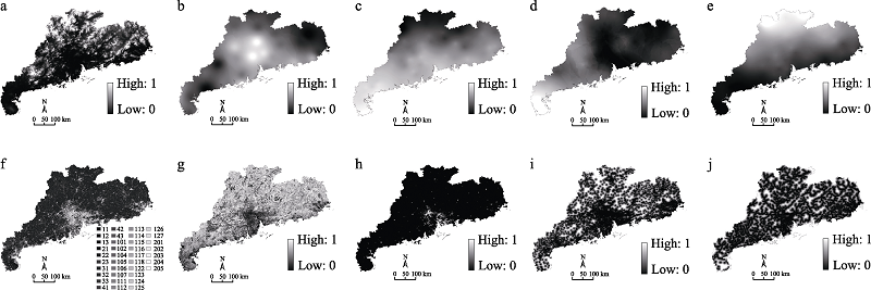
Fig. 2 Environmental factors affecting the distribution of birds. a, Altitude; b, Annual precipitation; c, Annual mean temperature; d, Annual mean humidity; e, Annual average temperature difference; f, Land use; g, Normalized difference vegetation index; h, Population density; i, Distance from urban land; j, Distance from water.
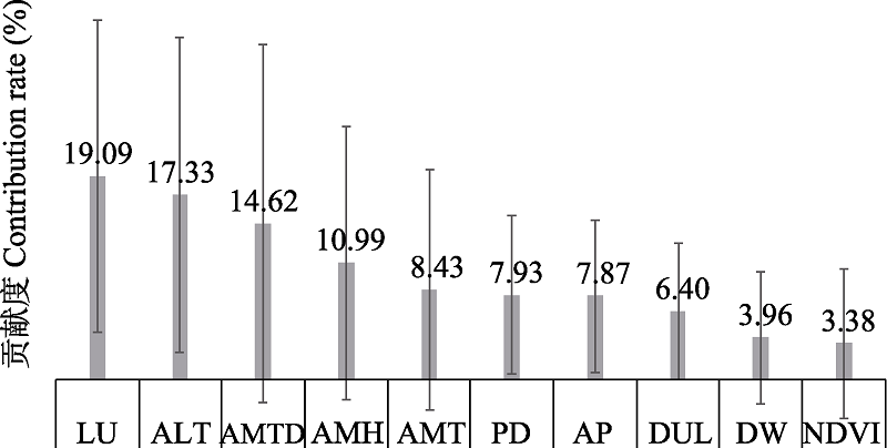
Fig. 3 Contribution rate of environmental factors. See Table 1 for abbreviations.
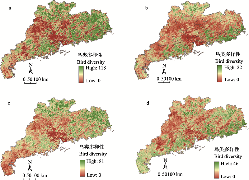
Fig. 4 Spatial patterns of all birds (a), protected birds (b), resident birds (c), migratory birds (d) biodiversity in Guangdong Province
| 生态保护红线 Ecological red line | 永久基本农田 Permanent basic farmland | 城镇开发边界 Urban development boundary | “三线”之外 Outside the three lines | ||
|---|---|---|---|---|---|
| 全部鸟类 All birds | 相交面积 Intersecting areas (km2) | 1,618.79 | 4,009.49 | 24.01 | 8,258.52 |
| 热点地区占比 Proportion (%) | 11.6 | 28.8 | 0.2 | 59.4 | |
| 保护鸟类 Protected birds | 相交面积 Intersecting areas (km2) | 218.44 | 1,880.32 | 65.95 | 2,618.58 |
| 热点地区占比 Proportion (%) | 4.6 | 39.3 | 1.4 | 54.8 | |
| 留鸟类 Resident birds | 相交面积 Intersecting areas (km2) | 1,776.68 | 2,856.25 | 3.17 | 6,654.16 |
| 热点地区占比 Proportion (%) | 15.7 | 25.3 | 0.1 | 59.0 | |
| 迁徙鸟类 Migratory birds | 相交面积 Intersecting areas (km2) | 445.13 | 3,103.25 | 210.07 | 5,872.09 |
| 热点地区占比 Proportion (%) | 4.6 | 32.2 | 2.2 | 61.0 | |
Table 2 The relationship between species richness and the ecological red line, permanent basic farmland and the urban development boundary
| 生态保护红线 Ecological red line | 永久基本农田 Permanent basic farmland | 城镇开发边界 Urban development boundary | “三线”之外 Outside the three lines | ||
|---|---|---|---|---|---|
| 全部鸟类 All birds | 相交面积 Intersecting areas (km2) | 1,618.79 | 4,009.49 | 24.01 | 8,258.52 |
| 热点地区占比 Proportion (%) | 11.6 | 28.8 | 0.2 | 59.4 | |
| 保护鸟类 Protected birds | 相交面积 Intersecting areas (km2) | 218.44 | 1,880.32 | 65.95 | 2,618.58 |
| 热点地区占比 Proportion (%) | 4.6 | 39.3 | 1.4 | 54.8 | |
| 留鸟类 Resident birds | 相交面积 Intersecting areas (km2) | 1,776.68 | 2,856.25 | 3.17 | 6,654.16 |
| 热点地区占比 Proportion (%) | 15.7 | 25.3 | 0.1 | 59.0 | |
| 迁徙鸟类 Migratory birds | 相交面积 Intersecting areas (km2) | 445.13 | 3,103.25 | 210.07 | 5,872.09 |
| 热点地区占比 Proportion (%) | 4.6 | 32.2 | 2.2 | 61.0 | |
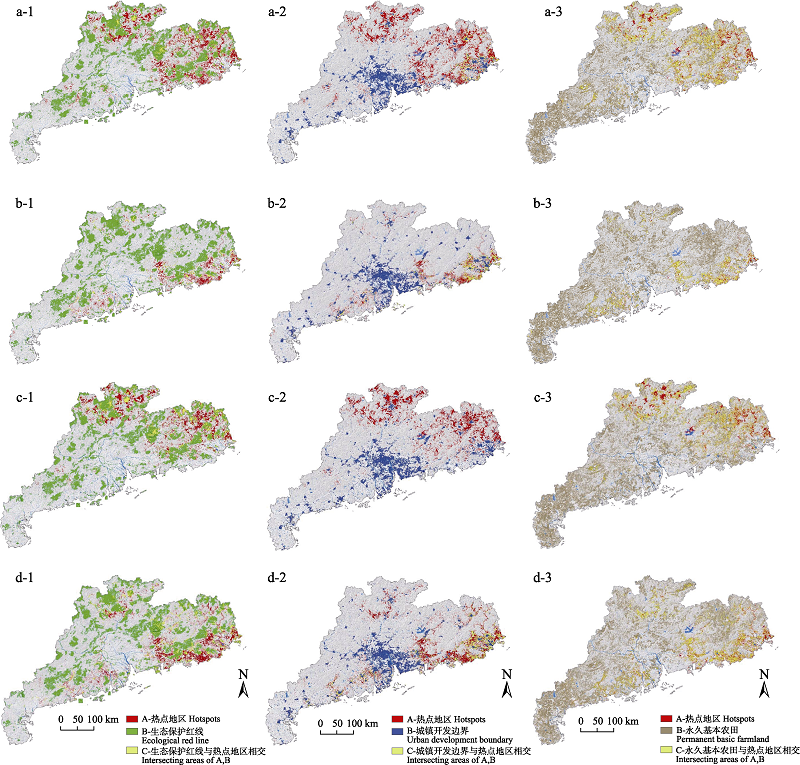
Fig. 5 The spatial relationship between all birds (a), protected birds (b), resident birds (c), migratory birds (d) and ecological red line, urban development boundary and permanent basic farmland
| [1] |
Blair RB (1996) Land use and avian species diversity along an urban gradient. Ecological Applications, 6, 506-519.
DOI URL |
| [2] |
Boubli JP, Lima M (2009) Modeling the geographical distribution and fundamental niches ofCacajao spp. andChiropotes israelita in northwestern Amazonia via a maximum entropy algorithm. International Journal of Primatology, 30, 217-228.
DOI URL |
| [3] |
Brooks TM, Mittermeier RAda Fonseca GAB, Gerlach J, Hoffmann M, Lamoreux JF, Mittermeier CG, Pilgrim JD, Rodrigues ASL (2006) Global biodiversity conservation priorities. Science, 313, 58-61.
PMID |
| [4] | Chang H, Chen WC, Lu KH, Lin S, Zhang GP (1997) A research on the bird community in Nanling National Nature Reserve of Guangdong Province. Acta Scientiarum Naturalium Universitatis Sunyatseni, 36(4),75-79. (in Chinese with English abstract) |
| [ 常弘, 陈万成, 卢开和, 林术, 张国萍 (1997) 广东南岭国家级自然保护区鸟类群落的研究. 中山大学学报(自然科学版), 36(4),75-79.] | |
| [5] | Chen XM, Lei YC, Zhang XQ, Jia HY (2012) Effects of sample sizes on accuracy and stability of maximum entropy model in predicting species distribution. Scientia Silvae Sinicae, 48(1),53-59. (in Chinese with English abstract) |
| [ 陈新美, 雷渊才, 张雄清, 贾宏炎 (2012) 样本量对MaxEnt模型预测物种分布精度和稳定性的影响. 林业科学, 48(1),53-59.] | |
| [6] |
Correa Ayram CA, Mendoza ME, Etter A, Pérez Salicrup DR (2017) Anthropogenic impact on habitat connectivity: A multidimensional human footprint index evaluated in a highly biodiverse landscape of Mexico. Ecological Indicators, 72, 895-909.
DOI URL |
| [7] |
Cui SP, Luo X, Li CW, Hu HJ, Jiang ZG (2018) Predicting the potential distribution of white-lipped deer using the MaxEnt model. Biodiversity Science, 26, 171-176. (in Chinese with English abstract)
DOI URL |
|
[ 崔绍朋, 罗晓, 李春旺, 胡慧建, 蒋志刚 (2018) 基于MaxEnt模型预测白唇鹿的潜在分布区. 生物多样性, 26, 171-176.]
DOI |
|
| [8] | Fan XS, Hu DF, Chen HZ, Wang F, Su X (2005) Study on the relationship between bird community structure and forest ecology in the cultivation areas of North China Plain. Arid Zone Research, 22, 186-191. (in Chinese with English abstract) |
| [ 范喜顺, 胡德夫, 陈合志, 王峰, 苏鑫 (2005) 华北平原耕作区鸟类群落结构与林业生态关系研究. 干旱区研究, 22, 186-191.] | |
| [9] | Hao XN, Wu YL (2017) Prediction of suitable habitat for overwintering hooded cranes (Grus monacha) based on MaxEnt modeling. Journal of Anhui Agricultural University, 44, 591-597. (in Chinese with English abstract) |
| [ 郝雪娜, 吴艳兰 (2017) 基于MaxEnt模型的越冬白头鹤适宜生境预测. 安徽农业大学学报, 44, 591-597.] | |
| [10] | He CY, Shi PJ, Chen J, Xu XL (2002) Process and mechanism of urbanization in Beijing area. Acta Geographica Sinica, 57, 363-371. (in Chinese with English abstract) |
| [ 何春阳, 史培军, 陈晋, 徐小黎 (2002) 北京地区城市化过程与机制研究. 地理学报, 57, 363-371.] | |
| [11] | Huang Y (2015) The Methodology of Bird Habitats' Making and Planning at Beijing Urban Green Spaces. PhD dissertation, Tsinghua University, Beijing. (in Chinese with English abstract) |
| [ 黄越 (2015) 北京城市绿地鸟类生境规划与营造方法研究. 博士学位论文, 清华大学, 北京.] | |
| [12] | Li JS, Gao JX, Zhang XL, Zheng XM (2005) Effects of urbanization on biodiversity. Chinese Journal of Ecology, 24, 953-957. (in Chinese with English abstract) |
| [ 李俊生, 高吉喜, 张晓岚, 郑筱梅 (2005) 城市化对生物多样性的影响研究综述. 生态学杂志, 24, 953-957.] | |
| [13] | Lin Y, Xu XY, Yi JF, Lu Z (2017) Potential predation and conservation vacancy analysis ofSyrmaticus humiae in Guangxi based on MaxEnt model. Sichuan Journal of Zoology, 36, 328-333. (in Chinese with English abstract) |
| [ 林源, 徐雪怡, 伊剑锋, 陆舟 (2017) 基于MaxEnt模型的广西黑颈长尾雉潜在栖息地预测与保护空缺分析. 四川动物, 36, 328-333.] | |
| [14] | Liu JP, Lü XG, Yang Q, Wang HX (2009) Wetland landscape ecological security patterns analysis and plan in northeast of Sanjiang Plain. Acta Ecologica Sinica, 29, 1083-1090. (in Chinese with English abstract) |
| [ 刘吉平, 吕宪国, 杨青, 王海霞 (2009) 三江平原东北部湿地生态安全格局设计. 生态学报, 29, 1083-1090.] | |
| [15] | Lockwood JL, McKinney ML (2001) Biotic Homogenization. Springer US, New York. |
| [16] | Luan XF (2003) Studies on Avian Community of Shanghai and Planning of Conservation. PhD dissertation, East China Normal University, Shanghai. (in Chinese with English abstract) |
| [ 栾晓峰 (2003) 上海鸟类群落特征及其保护规划研究. 博士学位论文, 华东师范大学, 上海.] | |
| [17] |
MacArthur RH, MacArthur JW, Preer J (1962) On bird species diversity. II. Prediction of bird census from habitat measurements. The American Naturalist, 96, 167-174.
DOI URL |
| [18] |
Owens HL, Campbell LP, Lynnette Dornak L, Saupe EE, Barve N, Soberón J, Ingenloff K, Lira-Noriega A, Hensz CM, Myers CE, Peterson AT (2013) Constraints on interpretation of ecological niche models by limited environmental ranges on calibration areas. Ecological Modelling, 263, 10-18.
DOI URL |
| [19] |
Padoa-schioppa E, Baietto M, Massa R, Bottoni L (2006) Bird communities as bioindicators: The focal species concept in agricultural landscapes. Ecological Indicators, 6, 83-93.
DOI URL |
| [20] |
Pearson RG, Raxworthy CJ, Nakamura M, Peterson AT (2007) Predicting species distributions from small numbers of occurrence records: A test case using cryptic geckos in Madagascar. Journal of Biogeography, 34, 102-117.
DOI URL |
| [21] |
Qi ZX, Xu WH, Xiong XY, Ouyang ZY, Zheng H, Gan DX (2011) Assessment of potential habitat forUrsus thibetanus in the Qinling Mountains. Biodiversity Science, 19, 343-352. (in Chinese with English abstract)
DOI URL |
|
[ 齐增湘, 徐卫华, 熊兴耀, 欧阳志云, 郑华, 甘德欣 (2011) 基于MaxEnt模型的秦岭山系黑熊潜在生境评价. 生物多样性, 19, 343-352.]
DOI |
|
| [22] | Quan Q, Tang X, Wu Y, Zou FS (2018) β-diversity of bird assemblages in the Nanling Mountain ranges. Tropical Geography, 38, 321-327, 346. (in Chinese with English abstract) |
| [ 权擎, 唐璇, 吴毅, 邹发生 (2018) 南岭山脉及周边鸟类β多样性分析. 热带地理, 38, 321-327, 346.] | |
| [23] |
Rands MRW, Adams WM, Bennun L, Butchart SHM, Clements A, Coomes D, Entwistle A, Hodge I, Kapos V, Scharlemann JPW, Sutherland WJ, Vira B (2010) Biodiversity conservation: Challenges beyond 2010. Science, 329, 1298-1303.
DOI URL |
| [24] |
Swets JA (1988) Measuring the accuracy of diagnostic systems. Science, 240, 1285-1293.
PMID |
| [25] | Tian B, Zhou YX, Zhang LQ, Ma ZJ, Yang B, Tang CD (2008) A GIS and remote sensing-based analysis of migratory bird habitat suitability for Chongming Dongtan Nature Reserve, Shanghai. Acta Ecologica Sinica, 28, 3049-3059. (in Chinese with English abstract) |
| [ 田波, 周云轩, 张利权, 马志军, 杨波, 汤臣栋 (2008) 遥感与GIS支持下的崇明东滩迁徙鸟类生境适宜性分析. 生态学报, 28, 3049-3059.] | |
| [26] |
Vale TR, Vale GR (1976) Suburban bird populations in west-central California. Journal of Biogeography, 3, 157.
DOI URL |
| [27] |
Vina A, Tuanmu M, Xu WH, Li Y, Ouyang ZY, DeFries R, Liu JG (2010) Range-wide analysis of wildlife habitat: Implications for conservation. Biological Conservation, 143, 1960-1969.
DOI URL |
| [28] | Wang JL, Chen Y (2004) Applications of 3S technology in wildlife habitat researches. Geography and Geo-information Science, 20, 44-47. (in Chinese with English abstract) |
| [ 王金亮, 陈姚 (2004) 3S技术在野生动物生境研究中的应用. 地理与地理信息科学, 20, 44-47.] | |
| [29] |
Wei Y, Lei GC (2019) From biocenosis to ecosystem: The theory trend of conserving ecosystem integrity in national parks. Journal of Natural Resources, 34, 1820-1832. (in Chinese with English abstract)
DOI URL |
| [ 魏钰, 雷光春 (2019) 从生物群落到生态系统综合保护: 国家公园生态系统完整性保护的理论演变. 自然资源学报, 34, 1820-1832.] | |
| [30] | Wu QM, Wang L, Zhu RP, Yang YB, Jin HY, Zou HF (2016) Nesting habitat suitability analysis of red-crowned crane in Zhalong Nature Reserve based on MaxEnt modeling. Acta Ecologica Sinica, 36, 3758-3764. (in Chinese with English abstract) |
| [ 吴庆明, 王磊, 朱瑞萍, 杨宇博, 金洪阳, 邹红菲 (2016) 基于MaxEnt模型的丹顶鹤营巢生境适宜性分析——以扎龙保护区为例. 生态学报, 36, 3758-3764.] | |
| [31] | Wu YB, Zhang ED (2000) Application of geographic information system in animal ecology. Ecological Science, 19, 51-56. (in Chinese with English abstract) |
| [ 吴咏蓓, 张恩迪 (2000) 地理信息系统(GIS)在动物生态学中的应用. 生态科学, 19, 51-56.] | |
| [32] |
Xing DL, Hao ZQ (2011) The principle of maximum entropy and its applications in ecology. Biodiversity Science, 19, 295-302. (in Chinese with English abstract)
DOI URL |
|
[ 邢丁亮, 郝占庆 (2011) 最大熵原理及其在生态学研究中的应用. 生物多样性, 19, 295-302.]
DOI |
|
| [33] | Xu XQ, Li X (2009) Review and preview of the urbanization in Pearl River Delta in the past 30 years of reform and opening up. Economic Geography, 29, 13-18. (in Chinese with English abstract) |
| [ 许学强, 李郇 (2009) 改革开放30年珠江三角洲城镇化的回顾与展望. 经济地理, 29, 13-18.] | |
| [34] |
Zhang Y, Lei KM, Zhang YK, Xiao CL, Yang YH, Sun HO, Li SJ (2012) Effects of vegetation, elevation and human disturbance on the distribution of large- and medium-sized wildlife: A case study in Jiuzhaigou Nature Reserve. Acta Ecologica Sinica, 32, 4228-4235. (in Chinese with English abstract)
DOI URL |
| [ 张跃, 雷开明, 张语克, 肖长林, 杨玉花, 孙鸿鸥, 李淑君 (2012) 植被、海拔、人为干扰对大中型野生动物分布的影响——以九寨沟自然保护区为例. 生态学报, 32, 4228-4235.] | |
| [35] |
Zhang YY, Zhou LZ, Wang QS, Wang XJ, Xing YJ (2008) Distribution pattern and hotspot analysis of breeding birds in Anhui Province. Biodiversity Science, 16, 305-312. (in Chinese with English abstract)
DOI URL |
|
[ 张有瑜, 周立志, 王岐山, 王新建, 邢雅俊 (2008) 安徽省繁殖鸟类分布格局和热点区分析. 生物多样性, 16, 305-312.]
DOI |
|
| [36] | Zheng GM (1984) Ecological distribution of birds in Beijing and its vicinity during summer. Zoological Research, 5, 29-40. (in Chinese with English abstract) |
| [ 郑光美 (1984) 北京及其附近地区夏季鸟类的生态分布. 动物学研究, 5, 29-40.] | |
| [37] | Zheng GM (2005) A Checklist on the Classification and Distribution of the Birds of China. Science Press, Beijing. (in Chinese) |
| [ 郑光美 (2005) 中国鸟类分类与分布名录. 科学出版社, 北京.] | |
| [38] | Zhou LZ, Li DQ, Ma Y, Ye XD (1999) GIS approaches to studying animal diversity. Chinese Journal of Zoology, 34(5),52-56. (in Chinese) |
| [ 周立志, 李迪强, 马勇, 叶晓堤 (1999) 地理信息系统(GIS)在动物多样性研究中的应用. 动物学杂志, 34(5),52-56.] | |
| [39] |
Zhu GP, Qiao HJ (2016) Effect of the MaxEnt model's complexity on the prediction of species potential distributions. Biodiversity Science, 24, 1189-1196. (in Chinese with English abstract)
DOI URL |
|
[ 朱耿平, 乔慧捷 (2016) MaxEnt模型复杂度对物种潜在分布区预测的影响. 生物多样性, 24, 1189-1196.]
DOI |
| [1] | Zezhou Hao, Xiaoli Shen, Xingfeng Si, Yanyan Zhao, Chentao Wei, Fei Wu, Xiaoqing Xu, Pinjia Que, Lu Dong, Fangyuan Hua, Lixun Zhang, Chengyun Zhang, Yang Liu. Standards and recommendations for passive acoustic monitoring of birds in China [J]. Biodiv Sci, 2026, 34(5): 25474-. |
| [2] | Shengnan Ji, Jiarong Han, Yueheng Ren, Xiaodong Mu, Yanpeng Zhu. Prediction of suitable habitats and risk assessment for key invasive alien plant species on Hainan Island based on the MaxEnt model [J]. Biodiv Sci, 2025, 33(8): 25037-. |
| [3] | Lü Zhou, Hua Guo, Shimao Yao, Cheng Tian. The spatio-temporal distribution patterns of Tragopan temminckii in Wanglang National Nature Reserve [J]. Biodiv Sci, 2025, 33(7): 24537-. |
| [4] | Jinbo Xu, Yaqian Cui, Yuan Wang, Weibo Wang, Feng Liu, Guanglong Wang, Jingjing Hu, Dunzhu Pubu, Duoji Bianba, Zeng Dan, Kai Hu, Xiaochuan Wang, Gang Song, Yonglei Lü, Zhixin Wen. Habitat suitability evaluation of Macaca leucogenys in the Xizang Yarlung Zangbo Grand Canyon National Nature Reserve [J]. Biodiv Sci, 2025, 33(7): 24493-. |
| [5] | Wenyan Chen, Xiuqin Ci, Junling Chen, Zhifang Liu, Lang Li, Jie Li. Multidimensional diversity patterns and their environmental drivers of Lauraceae plants in Yunnan [J]. Biodiv Sci, 2025, 33(6): 24558-. |
| [6] | Huan Xu, Fengfei Xin, Hongliang Shi, Lin Yuan, Shunqi Bo, Xinyi Zhao, Shuaitao Deng, Tingting Pan, Jing Yu, Saisai Sun, Cheng Xue. Evaluation of effects of integrated ecological restoration technology on habitat and bird diversity improvement in the North Branch of Yangtze River Estuary [J]. Biodiv Sci, 2025, 33(5): 24478-. |
| [7] | Jing Gan, Xiangxu Liu, Xueming Lu, Xing Yue. China’s large cities in global biodiversity hotspots: Conservation policies and optimization directions [J]. Biodiv Sci, 2025, 33(5): 24529-. |
| [8] | Liao Yaqing, Huang Zefeng, Wang Xiaoyun, Zhang Libiao, Wu Yi, Yu Wenhua. An updated checklist of Chiroptera in Guangdong Province and a molecular barcode database [J]. Biodiv Sci, 2025, 33(4): 24584-. |
| [9] | Fu Mengdi, Zhu Yanpeng, Ren Yueheng, Li Shuang, Qin Le, Xie Zhengjun, Wang Qingchun, Zhang Libo. Research on the optimization of wildlife passage spatial layout in Xinjiang [J]. Biodiv Sci, 2025, 33(3): 24346-. |
| [10] | Chengxun Jiang, Taxing Zhang, Zihao Quan, Ying Liu, Luyan Chai, Jianghong Ran. The richness pattern and hotspot areas of national key protected wild birds on the Qinghai-Xizang Plateau [J]. Biodiv Sci, 2025, 33(11): 25171-. |
| [11] | Zhikai Liao, Haotian Bai, Xiuhan Zhang, Shang Yu, Jiale Ling, Yang Liu. A dataset of common bird vocalizations in Hainan Tropical Rainforest National Park [J]. Biodiv Sci, 2025, 33(11): 25194-. |
| [12] | Zhenyuan Liu, Haomiao Zhang, Tingting Zhou, Yuxin Tan, Bo-Ping Han. A dataset on the checklist and geographical distributions of Odonata from Guangdong, China [J]. Biodiv Sci, 2025, 33(10): 25348-. |
| [13] | Haotian Bai, Shang Yu, Xinyuan Pan, Jiale Ling, Juan Wu, Kaiqi Xie, Yang Liu, Xueye Chen. AI-assisted recognition for passive acoustic monitoring of birds in urban wetland parks [J]. Biodiv Sci, 2024, 32(8): 24188-. |
| [14] | Fei Duan, Mingzhang Liu, Hongliang Bu, Le Yu, Sheng Li. Effects of urbanization on bird community composition and functional traits: A case study of the Beijing-Tianjin-Hebei region [J]. Biodiv Sci, 2024, 32(8): 23473-. |
| [15] | Yanli Wang, Ying Zhang, Chunlin Qi, Changda Zhang, Youhai Shi, Yanjun Du, Qiong Ding. Identifying biodiversity hotspots and conservation gaps in Hainan Tropical Rainforest National Park based on macrofungi and plants perspectives [J]. Biodiv Sci, 2024, 32(7): 24081-. |
| Viewed | ||||||
|
Full text |
|
|||||
|
Abstract |
|
|||||
Copyright © 2026 Biodiversity Science
Editorial Office of Biodiversity Science, 20 Nanxincun, Xiangshan, Beijing 100093, China
Tel: 010-62836137, 62836665 E-mail: biodiversity@ibcas.ac.cn