
Biodiv Sci ›› 2023, Vol. 31 ›› Issue (3): 22161. DOI: 10.17520/biods.2022161 cstr: 32101.14.biods.2022161
• Original Papers: Animal Diversity • Previous Articles Next Articles
Qiongyue Zhang1, Zhuodi Deng2, Xuebin Hu3, Zhifeng Ding1, Rongbo Xiao4, Chen Xiu5, Zhenghao Wu1,6, Guang Wang7, Donghui Han7, Yuke Zhang8, Jianchao Liang1,*( ), Huijian Hu1,*()
Received:2022-10-28
Accepted:2022-12-16
Online:2023-03-20
Published:2023-03-20
Contact:
Jianchao Liang,Huijian Hu
About author:First author contact:#Co-first authors
Qiongyue Zhang, Zhuodi Deng, Xuebin Hu, Zhifeng Ding, Rongbo Xiao, Chen Xiu, Zhenghao Wu, Guang Wang, Donghui Han, Yuke Zhang, Jianchao Liang, Huijian Hu. The impact of urbanization on regional bird distribution and habitat connectivity in the Guangdong-Hong Kong-Macao Greater Bay Area[J]. Biodiv Sci, 2023, 31(3): 22161.
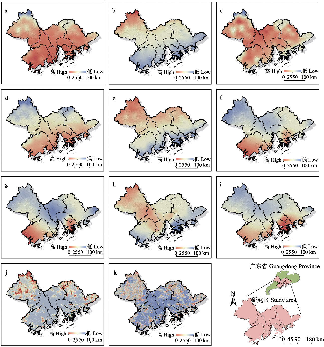
Fig. 1 Climate factors in Guangdong-Hong Kong-Macao Greater Bay Area during 2015. a, Annual mean temperature, AMT; b, Temperature seasonality, TS; c, Maximum temperature of the warmest month, MTWM; d, Minimum temperature of the coldest month, MTCM; e, Temperature annual range, TAR; f, Annual precipitation, AP; g, Precipitation of the wettest month, PWM; h, Precipitation of the driest month, PDM; i, Precipitation seasonality, PS; j, Elevation, ELEV; k, Slope, SLP.
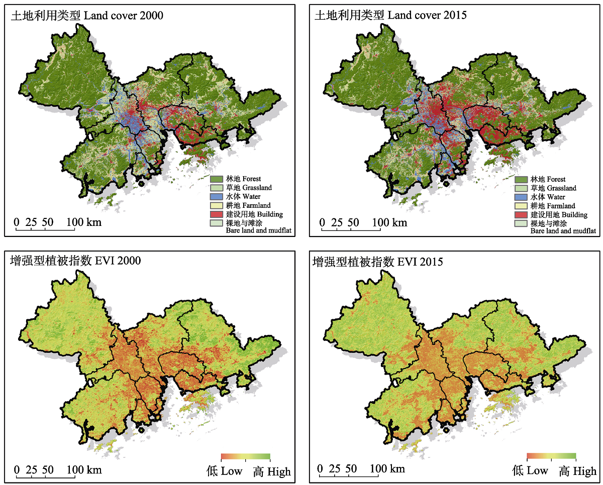
Fig. 2 Changes of urbanization environmental factors (land cover, enhanced vegetation index, EVI) in Guangdong-Hong Kong-Macao Greater Bay Area from 2000 to 2015
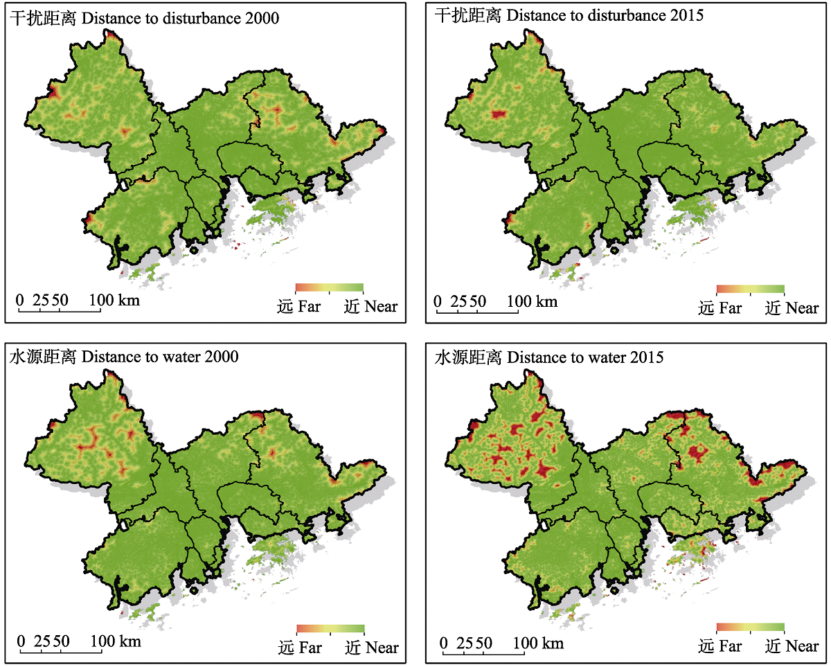
Fig. 3 Changes of urbanization environmental factors (distance to disturbance, distance to water) in Guangdong-Hong Kong-Macao Greater Bay Area from 2000 to 2015
| 2000年各土地利用类型 Land use types in 2000 | 2015年各土地利用类型面积 Areas of each land use type in 2015 (km2) | |||||||
|---|---|---|---|---|---|---|---|---|
| 草地 Grassland | 耕地 Farmland | 建设用地 Building | 林地 Forest | 裸地与滩涂 Bare land and mudflat | 水体 Water | 合计 Total | 变化比例 Change proportion | |
| 草地 Grassland | 41.78 | 3.48 | 10.34 | 10.54 | 0.60 | 2.09 | 68.82 | 33.95% |
| 耕地 Farmland | 4.28 | 7,189.09 | 2,281.25 | 1,098.99 | 18.08 | 1,166.84 | 11,758.51 | -23.19% |
| 建设用地 Building | 4.08 | 193.32 | 4,029.98 | 201.58 | 2.59 | 61.64 | 4,493.19 | 80.34% |
| 林地 Forest | 38.37 | 1,159.69 | 982.76 | 30,786.88 | 235.41 | 252.75 | 33,455.86 | -3.22% |
| 裸地与滩涂 Bare land and mudflat | 0.00 | 4.18 | 6.47 | 34.06 | 1.89 | 1.70 | 48.29 | 453.52% |
| 水体 Water | 3.69 | 481.67 | 792.11 | 246.15 | 8.74 | 3,341.68 | 4,874.04 | -0.97% |
| 合计 Total | 92.19 | 9,031.43 | 8,102.90 | 32,378.20 | 267.30 | 4,826.70 | 54,698.71 | |
Table 1 Matrix of the change of land use types in the Guangdong-Hong Kong-Macao Greater Bay Area between 2000 and 2015
| 2000年各土地利用类型 Land use types in 2000 | 2015年各土地利用类型面积 Areas of each land use type in 2015 (km2) | |||||||
|---|---|---|---|---|---|---|---|---|
| 草地 Grassland | 耕地 Farmland | 建设用地 Building | 林地 Forest | 裸地与滩涂 Bare land and mudflat | 水体 Water | 合计 Total | 变化比例 Change proportion | |
| 草地 Grassland | 41.78 | 3.48 | 10.34 | 10.54 | 0.60 | 2.09 | 68.82 | 33.95% |
| 耕地 Farmland | 4.28 | 7,189.09 | 2,281.25 | 1,098.99 | 18.08 | 1,166.84 | 11,758.51 | -23.19% |
| 建设用地 Building | 4.08 | 193.32 | 4,029.98 | 201.58 | 2.59 | 61.64 | 4,493.19 | 80.34% |
| 林地 Forest | 38.37 | 1,159.69 | 982.76 | 30,786.88 | 235.41 | 252.75 | 33,455.86 | -3.22% |
| 裸地与滩涂 Bare land and mudflat | 0.00 | 4.18 | 6.47 | 34.06 | 1.89 | 1.70 | 48.29 | 453.52% |
| 水体 Water | 3.69 | 481.67 | 792.11 | 246.15 | 8.74 | 3,341.68 | 4,874.04 | -0.97% |
| 合计 Total | 92.19 | 9,031.43 | 8,102.90 | 32,378.20 | 267.30 | 4,826.70 | 54,698.71 | |
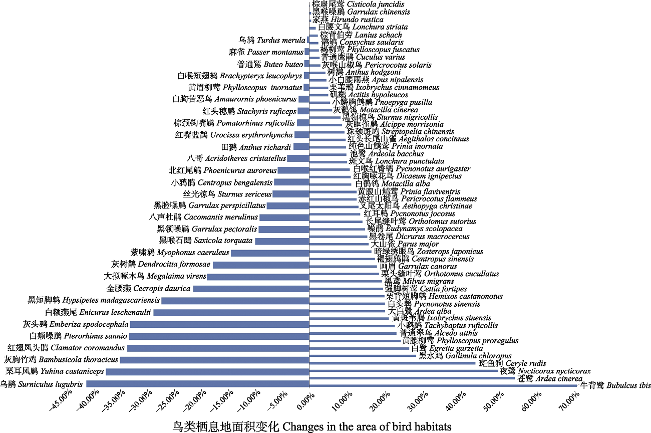
Fig. 4 Changes in the area of bird habitats in the process of urbanization of the Guangdong-Hong Kong-Macao Greater Bay Area from 2000 to 2015
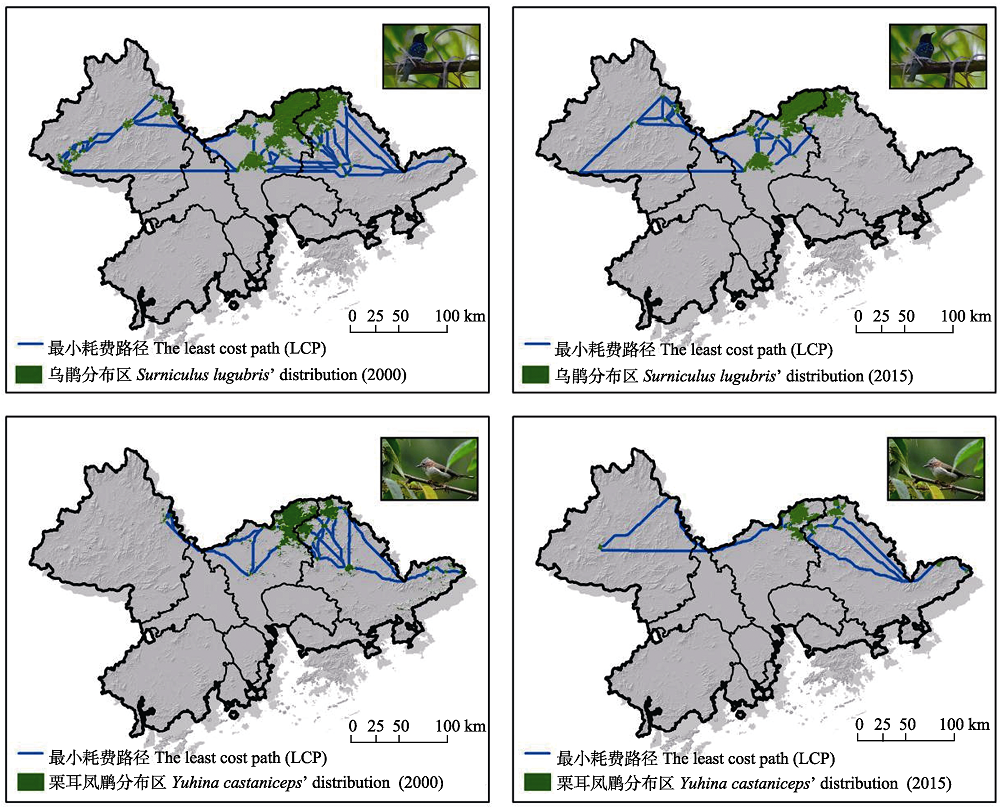
Fig. 5 Distribution changes of the core patches of bird habitat (Surniculus lugubris, Yuhina castaniceps) and the least cost path among them under the process of urbanization in Guangdong-Hong Kong-Macao Greater Bay Area from 2000 to 2015
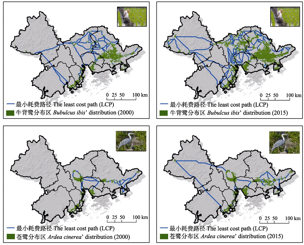
Fig. 6 Changes in the core patch of bird habitat and the least cost path between the core patches under the process of urbanization (Bubulcus ibis, Ardea cinerea)
| 物种 Species | 分布面积 Distribution area (km2) | 栖息地面积变化 The change of habitat area (dA) | 等效连接面积 The equivalent connected area (ECA) (km2) | 等效连接面积的变化 dECA | 等效连接面积变化比值 rECA | ||
|---|---|---|---|---|---|---|---|
| 2000 | 2015 | 2000 | 2015 | ||||
| 苍鹭 Ardea cinerea | 21.68 | 33.22 | 0.53 | 1,140.81 | 2,150.92 | 0.89 | 1.66 |
| 牛背鹭 Bubulcus ibis | 47.27 | 80.05 | 0.69 | 3,113.29 | 5,993.31 | 0.93 | 1.33 |
| 乌鹃 Surniculus lugubris | 41.30 | 23.75 | -0.43 | 3,506.69 | 2,152.00 | -0.39 | 0.91 |
| 栗耳凤鹛 Yuhina castaniceps | 17.65 | 10.80 | -0.39 | 1,396.05 | 916.29 | -0.34 | 0.88 |
Table 2 Changes of distribution area and the equivalent connected area index of the four representative bird species in Guangdong-Hong Kong-Macao Greater Bay Area from 2000 to 2015.
| 物种 Species | 分布面积 Distribution area (km2) | 栖息地面积变化 The change of habitat area (dA) | 等效连接面积 The equivalent connected area (ECA) (km2) | 等效连接面积的变化 dECA | 等效连接面积变化比值 rECA | ||
|---|---|---|---|---|---|---|---|
| 2000 | 2015 | 2000 | 2015 | ||||
| 苍鹭 Ardea cinerea | 21.68 | 33.22 | 0.53 | 1,140.81 | 2,150.92 | 0.89 | 1.66 |
| 牛背鹭 Bubulcus ibis | 47.27 | 80.05 | 0.69 | 3,113.29 | 5,993.31 | 0.93 | 1.33 |
| 乌鹃 Surniculus lugubris | 41.30 | 23.75 | -0.43 | 3,506.69 | 2,152.00 | -0.39 | 0.91 |
| 栗耳凤鹛 Yuhina castaniceps | 17.65 | 10.80 | -0.39 | 1,396.05 | 916.29 | -0.34 | 0.88 |
| [1] |
Alagador D, Cerdeira JO, Araújo MB (2016) Climate change, species range shifts and dispersal corridors: An evaluation of spatial conservation models. Methods in Ecology and Evolution, 7, 853-866.
DOI URL |
| [2] |
Aráujo MB, New M (2007) Ensemble forecasting of species distributions. Trends in Ecology & Evolution, 22, 42-47.
DOI URL |
| [3] | Bai XH, Wang WJ, Jiang WG, Shi HD, Chen K, Chen M (2019) Simulation of potential suitable distribution of endangered waterfowl and its gap analysis of national nature reserves in Beijing-Tianjin-Hebei region under climate change scenarios. Research of Environmental Sciences, 32, 1001-1011. (in Chinese with English abstract) |
| [白雪红, 王文杰, 蒋卫国, 师华定, 陈坤, 陈民 (2019) 气候变化背景下京津冀地区濒危水鸟潜在适宜区模拟及保护空缺分析. 环境科学研究, 32, 1001-1011.] | |
| [4] |
Bonier F, Martin PR, Wingfield JC (2007) Urban birds have broader environmental tolerance. Biology Letters, 3, 670-673.
PMID |
| [5] |
Brodie JF, Paxton M, Nagulendran K, Balamurugan G, Clements GR, Reynolds G, Jain A, Hon J (2016) Connecting science, policy, and implementation for landscape-scale habitat connectivity. Conservation Biology, 30, 950-961.
DOI PMID |
| [6] | Chen JSH, Yang MZ (2017) Characteristics and driving factors of land use transfer in economically developed coastal regions—A case of Nanshan District, Shenzhen. Territory & Natural Resources Study, (2), 41-44. (in Chinese with English abstract) |
| [陈江实浩, 杨木壮 (2017) 沿海经济发达地区土地利用转移特征及驱动因素: 以深圳市南山区为例. 国土与自然资源研究, (2), 41-44.] | |
| [7] |
Cumming GS, Buerkert A, Hoffmann EM, Schlecht E, von Cramon-Taubadel S, Tscharntke T (2014) Implications of agricultural transitions and urbanization for ecosystem services. Nature, 515, 50-57.
DOI |
| [8] | Ding ZF, Liang JC, Feng YJ, Liu JC, Hu HJ (2020) Functional and phylogenetic diversity of birds in urban habitat patches in Macao, China. Chinese Journal of Ecology, 39, 1238-1247. (in Chinese with English abstract) |
| [丁志锋, 梁健超, 冯永军, 刘金成, 胡慧建 (2020) 澳门城市栖息地斑块中鸟类群落功能和谱系多样性. 生态学杂志, 39, 1238-1247.] | |
| [9] |
Dilts TE, Weisberg PJ, Leitner P, Matocq MD, Inman RD, Nussear KE, Esque TC (2016) Multiscale connectivity and graph theory highlight critical areas for conservation under climate change. Ecological Applications, 26, 1223-1237.
DOI URL |
| [10] |
Elith J, Graham CH, Anderson RP, Dudík M, Ferrier S, Guisan A, Hijmans RJ, Huettmann F, Leathwick JR, Lehmann A, Li J, Lohmann LG, Loiselle BA, Manion G, Moritz C, Nakamura M, Nakazawa Y, Overton JM, Townsend Peterson A, Phillips SJ, Richardson K, Scachetti-Pereira R, Schapire RE, Soberón J, Williams S, Wisz MS, Zimmermann NE (2006) Novel methods improve prediction of species’ distributions from occurrence data. Ecography, 29, 129-151.
DOI URL |
| [11] |
Elith J, Phillips SJ, Hastie T, Dudík M, Chee YE, Yates CJ (2011) A statistical explanation of MaxEnt for ecologists. Diversity and Distributions, 17, 43-57.
DOI URL |
| [12] |
Fang CL, Liu HM, Li GD (2016) International progress and evaluation on interactive coupling effects between urbanization and the eco-environment. Journal of Geographical Sciences, 26, 1081-1116.
DOI URL |
| [13] |
Feng SS, Fan FL (2018) Spatiotemporal changes of landscape pattern using impervious surface in Guangdong-Hong Kong-Macao Greater Bay Area, China. Chinese Journal of Applied Ecology, 29, 2907-2914. (in Chinese with English abstract)
DOI |
|
[冯珊珊, 樊风雷 (2018) 基于不透水面的粤港澳大湾区景观格局时空变化. 应用生态学报, 29, 2907-2914.]
DOI |
|
| [14] | Gao M, Zeng H (2012) Dynamic change of the shoreline in Shenzhen during 1986-2020. Tropical Geography, 32, 274-279. (in Chinese) |
| [高梅, 曾辉 (2012) 深圳市1986-2020年间海岸线动态变化特征及成因分析. 热带地理, 32, 274-279.] | |
| [15] | Ghosal TK, Hossain S (2011) Conservation of globlally threatened migratorty waders through restoration of wetlands in an ecologically critical area—An experience from St. Martin’s Island, Bangladesh. China Wetland Culture Festival and Asian Wetland Forum, Wuxi, Jiangsu. (in Chinese with English abstract) |
| Ghosal TK, Hossain S (2011) 孟加拉圣马丁岛恢复湿地生态关键区保护全球濒危迁徙涉禽的经验. 中国湿地文化节暨亚洲湿地论坛, 江苏无锡.] | |
| [16] | Gibson L, Mcneill A, Tores P, Wayne A, Yates C (2010) Will future climate change threaten a range restricted endemic species, the quokka (Setonix brachyurus), in south west Australia? Biological Conservation, 143, 2453-2461. |
| [17] |
Guisan A, Zimmermann NE (2000) Predictive habitat distribution models in ecology. Ecological Modelling, 135, 147-186.
DOI URL |
| [18] | Guo L, Xia BC, Liu WQ, Jiang XD (2006) Spatio-temporal change and gradient differentiation of landscape pattern in Guangzhou City during its urbanization. Chinese Journal of Applied Ecology, 17, 1671-1676. (in Chinese with English abstract) |
| [郭泺, 夏北成, 刘蔚秋, 江学顶 (2006) 城市化进程中广州市景观格局的时空变化与梯度分异. 应用生态学报, 17, 1671-1676.] | |
| [19] |
Hu JH, Hu HJ, Jiang ZG (2010) The impacts of climate change on the wintering distribution of an endangered migratory bird. Oecologia, 164, 555-565.
DOI PMID |
| [20] | Kindlmann P, Burel F (2008) Connectivity measures: A review. Landscape Ecology, 23, 879-890. |
| [21] | Kong WY, Li XH, Zou HF (2019) Optimizing MaxEnt model in the prediction of species distribution. Chinese Journal of Applied Ecology, 30, 2116-2128. (in Chinese with English abstract) |
|
[孔维尧, 李欣海, 邹红菲 (2019) 最大熵模型在物种分布预测中的优化. 应用生态学报, 30, 2116-2128.]
DOI |
|
| [22] |
Liu CR, White M, Newell G (2013) Selecting thresholds for the prediction of species occurrence with presence-only data. Journal of Biogeography, 40, 778-789.
DOI URL |
| [23] |
Luo ZH, Jiang ZG, Tang SH (2015) Impacts of climate change on distributions and diversity of ungulates on the Tibetan Plateau. Ecological Applications, 25, 24-38.
DOI URL |
| [24] |
Ma ZJ, Cai YT, Li B, Chen JK (2010) Managing wetland habitats for waterbirds: An international perspective. Wetlands, 30, 15-27.
DOI URL |
| [25] |
Man WD, Liu MY, Wang ZM, Mao DH, Tian YL, Jia MM, Li X, Ren CY, Ouyang L (2017) Dynamics of habitat suitability for waterfowls from 1990 to 2015 in the ecological function zone of Sanjiang Plain, Northeast China. Chinese Journal of Applied Ecology, 28, 4083-4091. (in Chinese with English abstract)
DOI |
| [满卫东, 刘明月, 王宗明, 毛德华, 田艳林, 贾明明, 李想, 任春颖, 欧阳玲 (2017) 1990-2015年三江平原生态功能区水禽栖息地适宜性动态. 应用生态学报, 28, 4083-4091.] | |
| [26] |
Marmion M, Luoto M, Heikkinen RK, Thuiller W (2009) The performance of state-of-the-art modelling techniques depends on geographical distribution of species. Ecological Modelling, 220, 3512-3520.
DOI URL |
| [27] |
McMahon R, Stauffacher M, Knutti R (2015) The unseen uncertainties in climate change: Reviewing comprehension of an IPCC scenario graph. Climatic Change, 133, 141-154.
DOI URL |
| [28] |
Minor ES, Urban DL (2008) A graph-theory framework for evaluating landscape connectivity and conservation planning. Conservation Biology, 22, 297-307.
DOI PMID |
| [29] |
Opdam P, Wascher D (2004) Climate change meets habitat fragmentation: Linking landscape and biogeographical scale levels in research and conservation. Biological Conservation, 117, 285-297.
DOI URL |
| [30] | Ouyang ZY, Zheng H (2009) Ecological mechanisms of ecosystem services. Acta Ecologica Sinica, 29, 6183-6188. (in Chinese with English abstract) |
| [欧阳志云, 郑华 (2009) 生态系统服务的生态学机制研究进展. 生态学报, 29, 6183-6188.] | |
| [31] |
Phillips SJ, Anderson RP, Schapire RE (2006) Maximum entropy modeling of species geographic distributions. Ecological Modelling, 190, 231-259.
DOI URL |
| [32] |
Sala OE, Chapin FS III, Armesto JJ, Berlow E, Bloomfield J, Dirzo R, Huber-Sanwald E, Huenneke LF, Jackson RB, Kinzig A, Leemans R, Lodge DM, Mooney HA, Oesterheld M, Poff NL, Sykes MT, Walker BH, Walker M, Wall DH (2000) Global biodiversity scenarios for the year 2100. Science, 287, 1770-1774.
DOI PMID |
| [33] |
Saura S, Estreguil C, Mouton C, Freire MR (2011) Network analysis to assess landscape connectivity trends: Application to European forests (1990-2000). Ecological Indicators, 11, 407-416.
DOI URL |
| [34] |
Shcheglovitova M, Anderson RP (2013) Estimating optimal complexity for ecological niche models: A Jackknife approach for species with small sample sizes. Ecological Modelling, 269, 9-17.
DOI URL |
| [35] |
Thuiller W, Broennimann O, Hughes G, Alkemades JRM, Midgley GF, Corsi F (2006) Vulnerability of African mammals to anthropogenic climate change under conservative land transformation assumptions. Global Change Biology, 12, 424-440.
DOI URL |
| [36] | Wang CX, He JH, Liu DF, Yu XB, Shi QQ (2022) Impact of land use change on bird habitat connectivity: A case study in Ezhou City. Acta Ecologica Sinica, 42, 4197-4208. (in Chinese with English abstract) |
| [王春晓, 何建华, 刘殿锋, 于秀波, 石青青 (2022) 土地利用变化对鸟类栖息地连通性的影响——以鄂州市为例. 生态学报, 42, 4197-4208.] | |
| [37] | Wang WJ, Han BL, Zheng H, Ouyang ZY (2020) Evolution and simulation of ecosystem patterns in Guangdong-Hong Kong-Macau Bay Area. Acta Ecologica Sinica, 40, 3364-3374. (in Chinese with English abstract) |
| [王文静, 韩宝龙, 郑华, 欧阳志云 (2020) 粤港澳大湾区生态系统格局变化与模拟. 生态学报, 40, 3364-3374.] | |
| [38] |
Watling JI, Nowakowski AJ, Donnelly MA, Orrock JL (2011) Meta-analysis reveals the importance of matrix composition for animals in fragmented habitat. Global Ecology and Biogeography, 20, 209-217.
DOI URL |
| [39] | Xu S, Xu ZQ, Cui J, Yu XP (2013) Impact of urbanization on avian diversity in different landscapes in Xi’an City. Chinese Journal of Wildlife, 34, 327-330. (in Chinese with English abstract) |
| [徐沙, 许志强, 崔进, 于晓平 (2013) 城市化对西安市不同景观鸟类多样性的影响. 野生动物, 34, 327-330.] | |
| [40] | Yang D, Wang WJ (2019) Changes and driving forces of Anatidae’s potential habitat connectivity in Beijing-Tianjin- Hebei region from 1980 to 2015. Research of Environmental Sciences, 32, 547-556. (in Chinese with English abstract) |
| [杨丹, 王文杰 (2019) 1980-2015年京津冀地区雁鸭类潜在栖息地连接度变化及驱动因素. 环境科学研究, 32, 547-556.] | |
| [41] |
Yang XQ, Kushwaha SPS, Saran S, Xu JC, Roy PS (2013) MaxEnt modeling for predicting the potential distribution of medicinal plant, Justicia adhatoda L. in Lesser Himalayan foothills. Ecological Engineering, 51, 83-87.
DOI URL |
| [42] |
Zhang JP, Zhang YL, Liu LS, Nie Y (2011) Predicting potential distribution of Tibetan spruce (Picea smithiana) in Qomolangma (Mount Everest) National Nature Preserve using maximum entropy niche-based model. Chinese Geographical Science, 21, 417-426.
DOI URL |
| [43] |
Zhang KL, Yao LJ, Meng JS, Tao J (2018) MaxEnt modeling for predicting the potential geographical distribution of two peony species under climate change. Science of the Total Environment, 634, 1326-1334.
DOI URL |
| [44] |
Zhang YK, Mathewson PD, Zhang QY, Porter WP, Ran JH (2018) An ecophysiological perspective on likely giant panda habitat responses to climate change. Global Change Biology, 24, 1804-1816.
DOI PMID |
| [45] | Zhao N, Xia SX, Yu XB, Duan HL, Li JP, Chen YH (2020) Habitat suitability assessment of shorebirds in Bohai Bay coast using MaxEnt model. Chinese Journal of Ecology, 39, 194-205. (in Chinese with English abstract) |
| [赵宁, 夏少霞, 于秀波, 段后浪, 李瑾璞, 陈亚恒 (2020) 基于MaxEnt模型的渤海湾沿岸鸻鹬类栖息地适宜性评价. 生态学杂志, 39, 194-205.] | |
| [46] |
Zhou DQ, Fung T, Chu LM (2012) Avian community structure of urban parks in developed and new growth areas: A landscape-scale study in Southeast Asia. Landscape and Urban Planning, 108, 91-102.
DOI URL |
| [1] | Luyao Tian, Hao Yin. Research status and strategies for China’s ecological railway development based on biodiversity conservation [J]. Biodiv Sci, 2025, 33(8): 24495-. |
| [2] | Shengnan Ji, Jiarong Han, Yueheng Ren, Xiaodong Mu, Yanpeng Zhu. Prediction of suitable habitats and risk assessment for key invasive alien plant species on Hainan Island based on the MaxEnt model [J]. Biodiv Sci, 2025, 33(8): 25037-. |
| [3] | Lü Zhou, Hua Guo, Shimao Yao, Cheng Tian. The spatio-temporal distribution patterns of Tragopan temminckii in Wanglang National Nature Reserve [J]. Biodiv Sci, 2025, 33(7): 24537-. |
| [4] | Jinbo Xu, Yaqian Cui, Yuan Wang, Weibo Wang, Feng Liu, Guanglong Wang, Jingjing Hu, Dunzhu Pubu, Duoji Bianba, Zeng Dan, Kai Hu, Xiaochuan Wang, Gang Song, Yonglei Lü, Zhixin Wen. Habitat suitability evaluation of Macaca leucogenys in the Xizang Yarlung Zangbo Grand Canyon National Nature Reserve [J]. Biodiv Sci, 2025, 33(7): 24493-. |
| [5] | Fu Mengdi, Zhu Yanpeng, Ren Yueheng, Li Shuang, Qin Le, Xie Zhengjun, Wang Qingchun, Zhang Libo. Research on the optimization of wildlife passage spatial layout in Xinjiang [J]. Biodiv Sci, 2025, 33(3): 24346-. |
| [6] | Jiachen Wang, Tangjun Xu, Wei Xu, Gaoji Zhang, Yijin You, Honghua Ruan, Hongyi Liu. Impact of urban landscape pattern on the genetic structure of Thereuopoda clunifera population in Nanjing, China [J]. Biodiv Sci, 2025, 33(1): 24251-. |
| [7] | Yihui Jiang, Yue Liu, Xu Zeng, Zheying Lin, Nan Wang, Jihao Peng, Ling Cao, Cong Zeng. Fish diversity and connectivity in six national marine protected areas in the East China Sea [J]. Biodiv Sci, 2024, 32(6): 24128-. |
| [8] | Le Li, Chengyun Zhang, Nancai Pei, Bingtao Gao, Na Wang, Jiarui Li, Ruichen Wu, Zezhou Hao. Correlation analysis of urban green landscape patterns and bird diversity based on passive acoustic monitoring technology [J]. Biodiv Sci, 2024, 32(10): 24296-. |
| [9] | Wei Liu, Ruge Wang, Tianqiao Fan, Nayiman Abudulijiang, Xinhang Song, Shuping Xiao, Ning Guo, Lingying Shuai. Habitat suitability for the Aviceda leuphotes in Mingxi County, Fujian Province [J]. Biodiv Sci, 2023, 31(7): 22660-. |
| [10] | Zhiyuan Dong, Linlin Chen, Naipeng Zhang, Li Chen, Debin Sun, Yanmei Ni, Baoquan Li. Response of fish diversity to hydrological connectivity of typical tidal creek system in the Yellow River Delta based on environmental DNA metabarcoding [J]. Biodiv Sci, 2023, 31(7): 23073-. |
| [11] | Jirong Teng, Xingming Liu, Liwen He, Junliang Wang, Jian Huang, Jie Feng, Fang Wang, Yue Weng. The spatio-temporal impact of domestic dogs (Canis familiaris) on giant panda (Ailuropoda melanoleuca) in Baishuijiang National Nature Reserve [J]. Biodiv Sci, 2022, 30(1): 21204-. |
| [12] | Chen Zhang, Wei Ma, Chen Chen, Muyang Wang, Wenxuan Xu, Weikang Yang. Changes of habitat pattern for goitered gazelle in the Xinjiang Kalamaili Mountain Ungulate Nature Reserve under the influence of major projects [J]. Biodiv Sci, 2022, 30(1): 21176-. |
| [13] | Xing Ma, Hao Wang, Wei Yu, Yong Du, Jianchao Liang, Huijian Hu, Shengrong Qiu, Lu Liu. Analysis on the hotspot and conservation gaps of bird biodiversity in Guangdong Province based on MaxEnt model [J]. Biodiv Sci, 2021, 29(8): 1097-1107. |
| [14] | Run Zhou, Xiuqin Ci, Jianhua Xiao, Guanlong Cao, Jie Li. Effects and conservation assessment of climate change on the dominant group—The genusCinnamomum of subtropical evergreen broad-leaved forests [J]. Biodiv Sci, 2021, 29(6): 697-711. |
| [15] | Yuhan Shi, Zongxin Ren, Weijia Wang, Xin Xu, Jie Liu, Yanhui Zhao, Hong Wang. Predicting the spatial distribution of three Astragalusspecies and their pollinating bumblebees in the Sino-Himalayas [J]. Biodiv Sci, 2021, 29(6): 759-769. |
| Viewed | ||||||
|
Full text |
|
|||||
|
Abstract |
|
|||||
Copyright © 2026 Biodiversity Science
Editorial Office of Biodiversity Science, 20 Nanxincun, Xiangshan, Beijing 100093, China
Tel: 010-62836137, 62836665 E-mail: biodiversity@ibcas.ac.cn