
生物多样性 ›› 2025, Vol. 33 ›› Issue (3): 24346. DOI: 10.17520/biods.2024346 cstr: 32101.14.biods.2024346
付梦娣1( ), 朱彦鹏1, 任月恒1, 李爽1, 秦乐1, 谢正君2, 王清春3, 张立博1,*(
 )
)
收稿日期:2024-07-30
接受日期:2024-10-13
出版日期:2025-03-20
发布日期:2025-02-22
通讯作者:
*E-mail: zhang.libo@craes.org.cn
基金资助:
Fu Mengdi1(), Zhu Yanpeng1, Ren Yueheng1, Li Shuang1, Qin Le1, Xie Zhengjun2, Wang Qingchun3, Zhang Libo1,*()
Received:2024-07-30
Accepted:2024-10-13
Online:2025-03-20
Published:2025-02-22
Contact:
*E-mail: zhang.libo@craes.org.cn
Supported by:摘要: 线性基础设施的不断扩张已成为威胁生物多样性的重要因素之一。探索大尺度的野生动物通道优化路径对于区域生物多样性保护至关重要。本研究以新疆代表性野生动物为研究对象, 采用最大熵模型预测其潜在栖息地, 并对栖息地重要性进行评估。基于最小累积阻力模型计算线性基础设施影响的最小累积阻力路径, 结合现有及规划的道路、围栏, 精准识别提高栖息地连通性所需的通道位置和数量, 形成野生动物通道空间布局优化方案。结果表明: 不同代表性野生动物的栖息地分布呈现显著的生态差异, 其中食肉目动物主要分布于高山和亚高山地区, 而大型食草动物则偏好干旱荒漠地区。高阻力区域主要位于铁路和高速公路穿越自然保护地的地段。研究识别出2,494.98 km的通道区域及4,314个通道。道路的技术等级越高, 通道区域的长度和通道数量越多。尽管重要区域的通道总长度大于关键区域, 但关键区域的通道密度显著高于重要区域。建议根据线性基础设施的技术等级实施差异化的通道建设, 同时加强保护地外的通道布局优化, 以有效维持区域生态连通性。
付梦娣, 朱彦鹏, 任月恒, 李爽, 秦乐, 谢正君, 王清春, 张立博 (2025) 新疆野生动物通道空间布局优化. 生物多样性, 33, 24346. DOI: 10.17520/biods.2024346.
Fu Mengdi, Zhu Yanpeng, Ren Yueheng, Li Shuang, Qin Le, Xie Zhengjun, Wang Qingchun, Zhang Libo (2025) Research on the optimization of wildlife passage spatial layout in Xinjiang. Biodiversity Science, 33, 24346. DOI: 10.17520/biods.2024346.
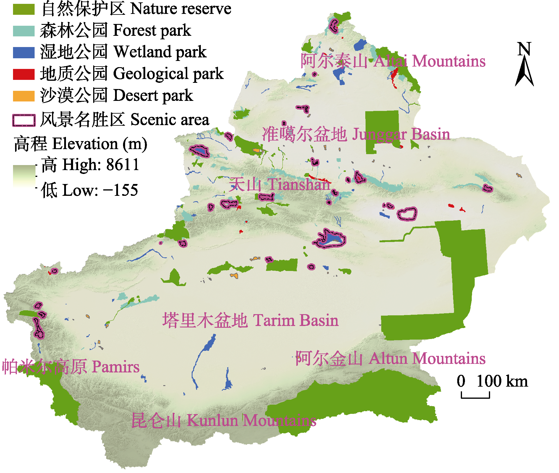
图1 新疆地貌及自然保护地空间分布图
Fig. 1 Spatial distribution of Xinjiang’s geomorphology and protected areas
| 物种 Species | 保护级别 Protection level | 濒危等级 Endangered status | 生境类型 Habitat types |
|---|---|---|---|
| 雪豹 Panthera uncia | I | EN | 岩石区域、草地和灌丛 Rocky regions, grasslands, and shrublands |
| 野骆驼 Camelus ferus | I | CR | 荒漠、半荒漠和灌丛 Deserts, semi-deserts, and shrublands |
| 马鹿 Cervus canadensis | II | EN | 森林、沼泽和草甸 Forests, swamps, and meadows |
| 蒙古野驴 Equus hemionus | I | VU | 荒漠 Deserts |
| 兔狲 Otocolobus manul | II | EN | 荒漠和草地 Deserts and grasslands |
| 猞猁 Lynx lynx | II | EN | 森林、草地、岩石区域和泰加林 Forests, grasslands, rocky regions, and taiga |
| 石貂 Martes foina | II | EN | 岩石区域、森林、灌丛和耕地 Rocky regions, forests, shrublands, and cultivated land |
| 鹅喉羚 Gazella subgutturosa | II | VU | 荒漠、半荒漠和牧场 Deserts, semi-deserts, and rangelands |
| 北山羊 Capra sibirica | II | NT | 草甸和岩石区域 Meadows and rocky regions |
| 赤狐 Vulpes vulpes | II | NT | 苔原、沙漠、森林、城市、灌丛和耕地 Tundra, deserts, forests, urban areas, shrublands, and cultivated land |
| 沙狐 Vulpes corsac | II | NT | 草甸和半荒漠地区 Meadows and semi-desert areas |
| 塔里木兔 Lepus yarkandensis | II | NT | 沙漠 Deserts |
表1 选择的代表性野生动物名录
Table 1 List of selected representative wildlife species
| 物种 Species | 保护级别 Protection level | 濒危等级 Endangered status | 生境类型 Habitat types |
|---|---|---|---|
| 雪豹 Panthera uncia | I | EN | 岩石区域、草地和灌丛 Rocky regions, grasslands, and shrublands |
| 野骆驼 Camelus ferus | I | CR | 荒漠、半荒漠和灌丛 Deserts, semi-deserts, and shrublands |
| 马鹿 Cervus canadensis | II | EN | 森林、沼泽和草甸 Forests, swamps, and meadows |
| 蒙古野驴 Equus hemionus | I | VU | 荒漠 Deserts |
| 兔狲 Otocolobus manul | II | EN | 荒漠和草地 Deserts and grasslands |
| 猞猁 Lynx lynx | II | EN | 森林、草地、岩石区域和泰加林 Forests, grasslands, rocky regions, and taiga |
| 石貂 Martes foina | II | EN | 岩石区域、森林、灌丛和耕地 Rocky regions, forests, shrublands, and cultivated land |
| 鹅喉羚 Gazella subgutturosa | II | VU | 荒漠、半荒漠和牧场 Deserts, semi-deserts, and rangelands |
| 北山羊 Capra sibirica | II | NT | 草甸和岩石区域 Meadows and rocky regions |
| 赤狐 Vulpes vulpes | II | NT | 苔原、沙漠、森林、城市、灌丛和耕地 Tundra, deserts, forests, urban areas, shrublands, and cultivated land |
| 沙狐 Vulpes corsac | II | NT | 草甸和半荒漠地区 Meadows and semi-desert areas |
| 塔里木兔 Lepus yarkandensis | II | NT | 沙漠 Deserts |
图2 新疆代表性野生动物潜在栖息地重要性空间分布图
Fig. 2 Spatial distribution map of the importance of potential habitats for representative wildlife in Xinjiang
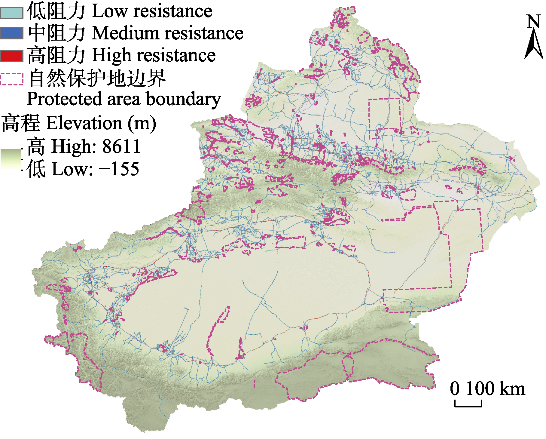
图3 新疆线性基础设施阻力面空间分布图
Fig. 3 Spatial distribution map of linear infrastructure resistance surfaces in Xinjiang
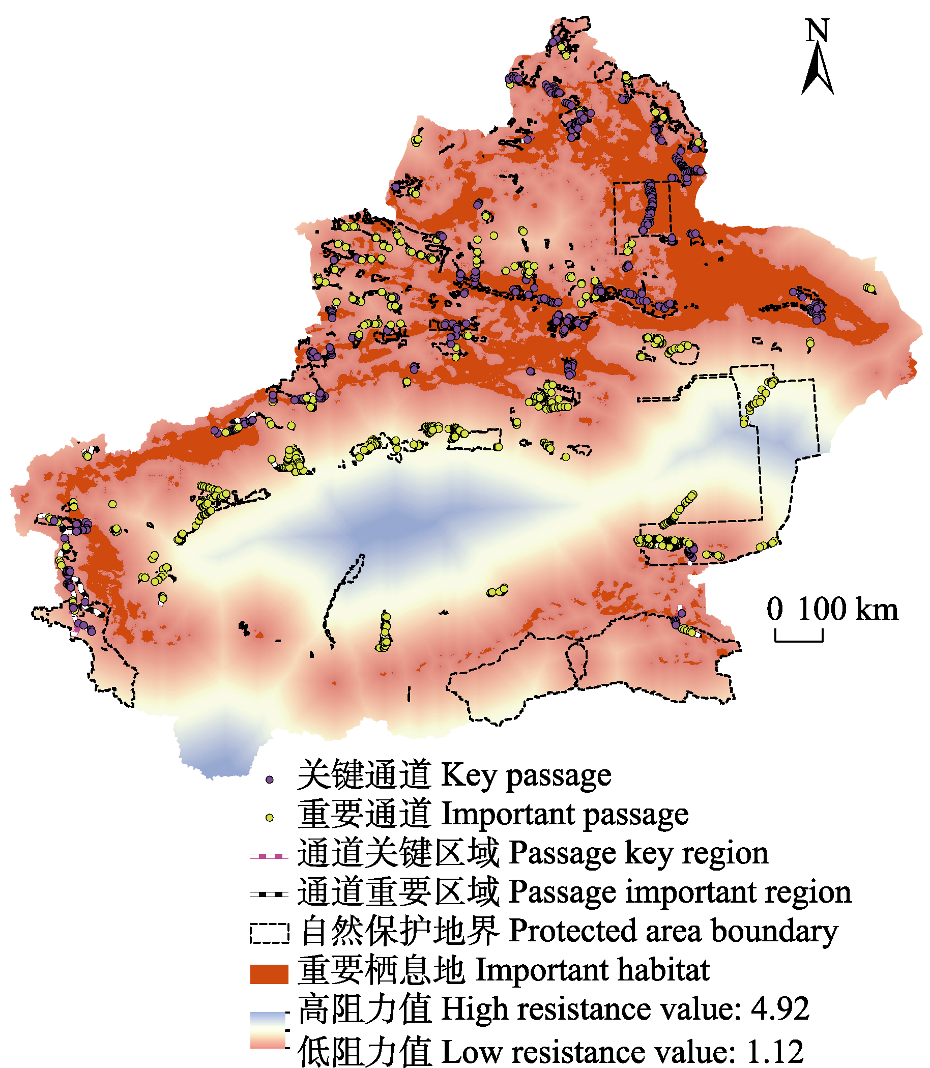
图4 新疆代表性野生动物通道优化布局
Fig. 4 Optimized spatial layout for representative wildlife passages in Xinjiang
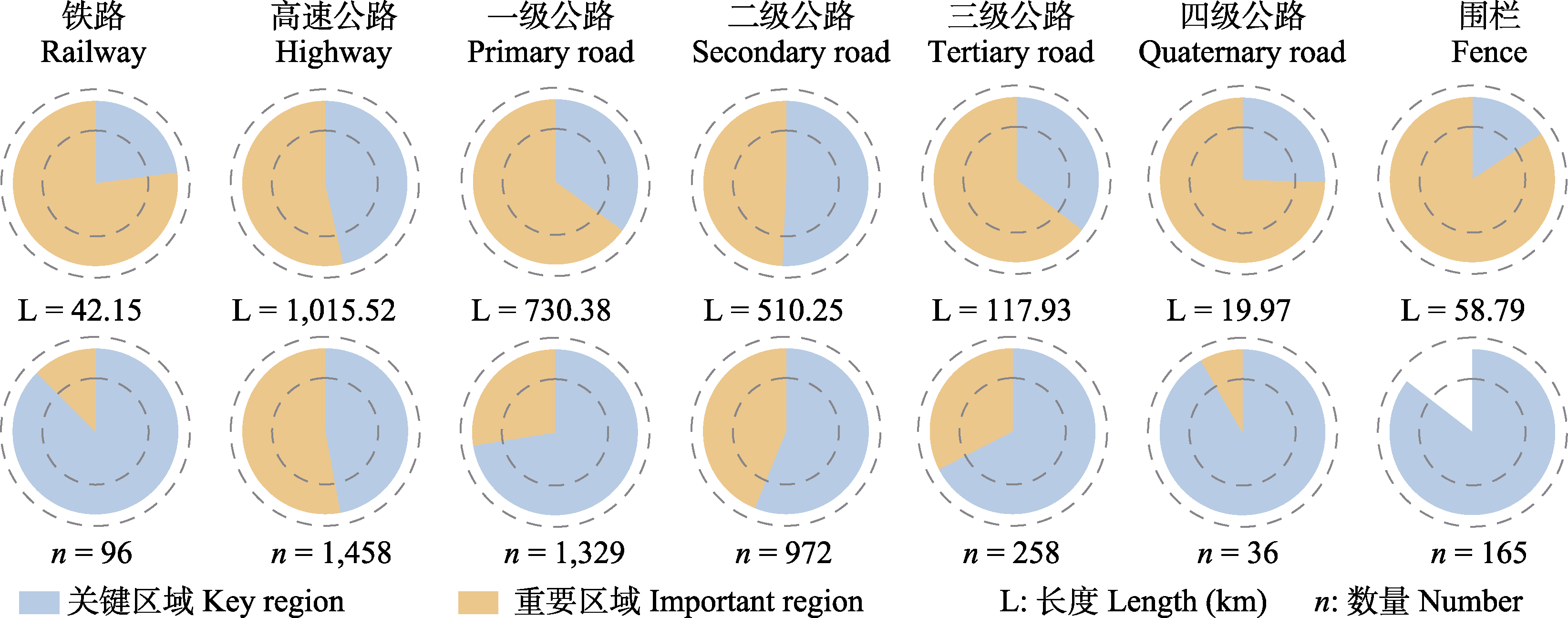
图5 新疆不同类型和等级的线性基础设施的通道统计
Fig. 5 Statistics of passages for different types and levels of linear infrastructure in Xinjiang
| [1] | Baechli J, Albanesi S, Bellis LM(2021) Effectiveness of crossings as wildlife passages for mammals in the Yungas of Argentina. Journal for Nature Conservation, 59, 125944. |
| [2] | Bakaloudis DE, Bontzorlos VA, Kotsonas E(2023) Wildlife mortality on roads crossing a protected area: The case of Dadia-Lefkimi-Soufli National Park in north-eastern Greece. Journal for Nature Conservation, 74, 126443. |
| [3] | Bliss-Ketchum LL, de Rivera CE, Turner BC, Weisbaum DM(2016) The effect of artificial light on wildlife use of a passage structure. Biological Conservation, 199, 25-28. |
| [4] | Chen XM, Lei YC, Zhang XQ, Jia HY(2012) Effects of sample sizes on accuracy and stability of maximum entropy model in predicting species distribution. Scientia Silvae Sinicae, 48(1), 53-59. (in Chinese with English abstract) |
| [ 陈新美, 雷渊才, 张雄清, 贾宏炎 (2012) 样本量对MaxEnt模型预测物种分布精度和稳定性的影响. 林业科学, 48(1), 53-59.] | |
| [5] |
Chu WW, Jiang ZG, Li K, Hu DF, Chen G, Chu HJ(2020) The snow leopard in Altai Mountains, near the Sino-Mongolia border, and its conservation significance. Biodiversity Science, 28, 442-444. (in Chinese with English abstract)
DOI |
|
[ 初雯雯, 蒋志刚, 李凯, 胡德夫, 陈刚, 初红军 (2020) 阿尔泰山中蒙边境地区的雪豹及其保护意义. 生物多样性, 28, 442-444.]
DOI |
|
| [6] | Coffin AW(2007) From roadkill to road ecology: A review of the ecological effects of roads. Journal of Transport Geography, 15, 396-406. |
| [7] | Demšar U, Harris P, Brunsdon C, Fotheringham AS, McLoone S(2013) Principal component analysis on spatial data: An overview. Annals of the Association of American Geographers, 103, 106-128. |
| [8] |
Dickson BG, Albano CM, Anantharaman R, Beier P, Fargione J, Graves TA, Gray ME, Hall KR, Lawler JJ, Leonard PB, Littlefield CE, McClure ML, Novembre J, Schloss CA, Schumaker NH, Shah VB, Theobald DM(2019) Circuit-theory applications to connectivity science and conservation. Conservation Biology, 33, 239-249.
DOI PMID |
| [9] |
Folland WR, Newsted JL, Fitzgerald SD, Fuchsman PC, Bradley PW, Kern J, Kannan K, Remington RE, Zwiernik MJ(2016) Growth and reproductive effects from dietary exposure to Aroclor 1268 in mink (Neovison vison), a surrogate model for marine mammals. Environmental Toxicology and Chemistry, 35, 604-618.
DOI PMID |
| [10] | Forman RT, Sperling D, Bissonette JA, Clevenger AP(2003) Road Ecology:Science and Solutions. Island Press, Washington, DC. |
| [11] | Forman RTT, Alexander LE(1998) Roads and their major ecological effects. Annual Review of Ecology and Systematics, 29, 207-231. |
| [12] | Fourcade Y, Engler JO, Rödder D, Secondi J(2014) Mapping species distributions with MaxEnt using a geographically biased sample of presence data: A performance assessment of methods for correcting sampling bias. PLoS ONE, 9, e97122. |
| [13] |
Gao XY, Xu WX, Yang WK, David AB, Qiao JF, Xu KF(2011) Status and distribution of ungulates in Xinjiang, China. Journal of Arid Land, 3, 49-60.
DOI |
| [14] | Geneletti D(2003) Biodiversity impact assessment of roads: An approach based on ecosystem rarity. Environmental Impact Assessment Review, 23, 343-365. |
| [15] | Hansen AJ, Rotella JJ(2002) Biophysical factors, land use, and species viability in and around nature reserves. Conservation Biology, 16, 1112-1122. |
| [16] | Jiang ZG, Liu SY, Wu Y, Jiang XL, Zhou KY(2017) China’s mammal diversity (2nd edition). Biodiversity Science, 25, 886-895. (in Chinese with English abstract) |
|
[ 蒋志刚, 刘少英, 吴毅, 蒋学龙, 周开亚 (2017) 中国哺乳动物多样性(第2版). 生物多样性, 25, 886-895.]
DOI |
|
| [17] |
Johnson DS, London JM, Lea MA, Durban JW(2008) Continuous-time correlated random walk model for animal telemetry data. Ecology, 89, 1208-1215.
DOI PMID |
| [18] |
Kaczensky P, Adiya Y, von Wehrden H, Mijiddorj B, Walzer C, Güthlin D, Enkhbileg D, Reading RP(2014) Space and habitat use by wild Bactrian camels in the Transaltai Gobi of southern Mongolia. Biological Conservation, 169, 311-318.
DOI PMID |
| [19] | Li F, Ye YP, Song BW, Wang RS(2015) Evaluation of urban suitable ecological land based on the minimum cumulative resistance model: A case study from Changzhou, China. Ecological Modelling, 318, 194-203. |
| [20] | Li LP, Wang ZH, Zerbe S, Abdusalih N, Tang ZY, Ma M, Yin LK, Mohammat A, Han WX, Fang JY(2013) Species richness patterns and water-energy dynamics in the drylands of Northwest China. PLoS ONE, 8, e66450. |
| [21] | Li S, Zhang XF, Shi JB, Dong SK, Gao XX(2018) Effects of highway from Inner Mongolia to Xinjiang on habitat suitability of ungulates in Alashan desert. Chinese Journal of Ecology, 37, 103-110. (in Chinese with English abstract) |
| [ 李帅, 张相锋, 石建斌, 董世魁, 高晓霞 (2018) 蒙新高速公路对阿拉善荒漠区有蹄类野生动物生境适宜性的影响. 生态学杂志, 37, 103-110.] | |
| [22] | Li YQ, Xing SH, Liu SQ, Luo AD, Cui GF(2013) Designing method of terrestrial wildlife path. Journal of Beijing Forestry University, 35(6), 137-143. (in Chinese with English abstract) |
| [ 李玉强, 邢韶华, 刘生强, 罗爱东, 崔国发 (2013) 陆生野生动物通道设计方法. 北京林业大学学报, 35(6), 137-143.] | |
| [23] | Liang JC, Ding ZF, Xiao RB, Zou JJ, Hu HJ(2016) Location design of wildlife corridors based on animal movement path identification: A case study of the Wuhan-Shenzhen Highway. Acta Ecologica Sinica, 36, 8145-8153. (in Chinese with English abstract) |
| [ 梁健超, 丁志锋, 肖荣波, 邹洁建, 胡慧建 (2016) 基于物种运动路径识别的动物通道选址——以武深高速为例. 生态学报, 36, 8145-8153.] | |
| [24] | Liu CR, White M, Newell G(2013) Selecting thresholds for the prediction of species occurrence with presence-only data. Journal of Biogeography, 40, 778-789. |
| [25] | Ma KP, Qian YQ(1998) Biodiversity conservation and its research progress. Chinese Journal of Applied and Environmental Biology, 4, 95-99. (in Chinese) |
| [ 马克平, 钱迎倩 (1998) 生物多样性保护及其研究进展. 应用与环境生物学报, 4, 95-99.] | |
| [26] |
Maierdiyali A, Wang Y, Tao SC, Kong YP, Wang H, Lü Z(2022) Research status and challenges of road impacts on wildlife in China. Biodiversity Science, 30, 22209. (in Chinese with English abstract)
DOI |
|
[ 阿卜杜赛麦提·买尔迪亚力,王云, 陶双成, 孔亚平, 王昊, 吕植 (2022) 我国道路对野生动物影响研究的现状与挑战. 生物多样性, 30, 22209.]
DOI |
|
| [27] |
Mata C, Hervás I, Herranz J, Suárez F, Malo JE(2008) Are motorway wildlife passages worth building? Vertebrate use of road-crossing structures on a Spanish motorway. Journal of Environmental Management, 88, 407-415.
PMID |
| [28] | Park JJ, Woo DG, Oh DH, Park CH(2012) Site selection of wildlife passage for leopard cat in urban area using space syntax. Journal of the Korean Institute of Landscape Architecture, 40, 92-99. |
| [29] | Qi ZX, Xu WH, Xiong XY, Ouyang ZY, Zheng H, Gan DX(2011) Assessment of potential habitat for Ursus thibetanus in the Qinling Mountains. Biodiversity Science, 19, 343-352. (in Chinese with English abstract) |
|
[ 齐增湘, 徐卫华, 熊兴耀, 欧阳志云, 郑华, 甘德欣 (2011) 基于MAXENT模型的秦岭山系黑熊潜在生境评价. 生物多样性, 19, 343-352.]
DOI |
|
| [30] | Ren YH, Zhu YP, Fu MD, Wen C, Zhang MH, Yu SX, Jiang JP, Li JS(2022) Recognition endangered species hotspots and conservation gaps of the Yellow River Basin. Acta Ecologica Sinica, 42, 982-989. (in Chinese with English abstract) |
| [ 任月恒, 朱彦鹏, 付梦娣, 闻丞, 张明海, 于胜祥, 江建平, 李俊生 (2022) 黄河流域濒危物种保护热点区与保护空缺识别. 生态学报, 42, 982-989.] | |
| [31] | Sai Q, Li HQ, Wang D, Wang ZH, Lian XM(2022) The utilization of wildlife passages by migratory Tibetan antelope in Sanjiangyuan National Park: A case study of Wubei Bridge of Qinghai-Tibet Railway. Acta Theriologica Sinica, 42, 601-608. (in Chinese with English abstract) |
|
[ 赛青高娃, 李宏奇, 王东, 王子涵, 连新明 (2022) 三江源国家公园迁徙藏羚对野生动物通道的利用——以青藏铁路五北大桥为例. 兽类学报, 42, 601-608.]
DOI |
|
| [32] | Schaller GB, Li H, Talipu, Lu H, Ren JR, Qiu MJ, Wang HB(1987) Status of large mammals in the Taxkorgan Reserve, Xinjiang, China. Biological Conservation, 42, 53-71. |
| [33] | Testud G, Fauconnier C, Labarraque D, Lengagne T, Le Petitcorps Q, Picard D, Miaud C(2020) Acoustic enrichment in wildlife passages under railways improves their use by amphibians. Global Ecology and Conservation, 24, e01252. |
| [34] | Trombulak SC, Frissell CA(2000) Review of ecological effects of roads on terrestrial and aquatic communities. Conservation Biology, 14, 18-30. |
| [35] | Tuohetahong Y, Ahmat A, Shan WJ, Buweihailiqimu A, Tayerjan M, Mahmut H(2020) Potential habitat distribution of three species of Lepus in Xinjiang and effects of future climate change. Chinese Journal of Wildlife, 41, 70-79. (in Chinese with English abstract) |
| [ 伊拉木江·托合塔洪,阿迪力·艾合麦提, 单文娟, 布威海丽其姆·阿巴拜科日, 塔依尔江·麦麦提, 马合木提·哈力克 (2020) 新疆兔属三物种潜在生境分布及未来气候变化的影响. 野生动物学报, 41, 70-79.] | |
| [36] | van der Sluijs J, MacKay G, Andrew L, Smethurst N, Andrews TD(2020) Archaeological documentation of wood caribou fences using unmanned aerial vehicle and very high-resolution satellite imagery in the Mackenzie Mountains, Northwest Territories. Journal of Unmanned Vehicle Systems, 8, 186-206. |
| [37] | Wang RF, Zhu SX, Guo ZL, Lin H, Wang QC, Cui GF(2025) The comprehensive geographical regionalization supporting natural conservation in Xinjiang. Acta Ecologica Sinica, 45, 539-553. (in Chinese with English abstract) |
| [ 王锐锋, 朱舒欣, 郭子良, 林海, 王清春, 崔国发 (2025) 新疆自然保护综合地理区划. 生态学报, 45, 539-553.] | |
| [38] | Wang Y, Guan L, Piao ZJ, Wang ZC, Kong YP(2017) Monitoring wildlife crossing structures along highways in Changbai Mountain, China. Transportation Research Part D: Transport and Environment, 50, 119-128. |
| [39] | Wang Y, Piao ZJ, Guan L, Kong YP(2013) Influence of ring Changbai Mountain scenic highway on wildlife. Chinese Journal of Ecology, 32, 425-435. (in Chinese with English abstract) |
| [ 王云, 朴正吉, 关磊, 孔亚平 (2013) 环长白山旅游公路对野生动物的影响. 生态学杂志, 32, 425-435.] | |
| [40] |
Wang YS, Xie BY, Wan FH, Xiao QM, Dai LY(2007) Application of ROC curve analysis in evaluating the performance of alien species’ potential distribution models. Biodiversity Science, 15, 365-372. (in Chinese with English abstract)
DOI |
|
[ 王运生, 谢丙炎, 万方浩, 肖启明, 戴良英 (2007) ROC曲线分析在评价入侵物种分布模型中的应用. 生物多样性, 15, 365-372.]
DOI |
|
| [41] | Warren DL, Wright AN, Seifert SN, Shaffer HB(2014) Incorporating model complexity and spatial sampling bias into ecological niche models of climate change risks faced by 90 California vertebrate species of concern. Diversity and Distributions, 20, 334-343. |
| [42] | Wu JG, Zhou QF(2011) Potential effect of climate change on distribution of 6 desert animals in China. Journal of Desert Research, 31, 464-475. (in Chinese with English abstract) |
| [ 吴建国, 周巧富 (2011) 气候变化对6种荒漠动物分布的潜在影响. 中国沙漠, 31, 464-475.] | |
| [43] | Wu M, Chen J, Zhao CC, Zhai R, Su YQ, Zheng JX, Hu XS(2020) Site selection of animal passage on Quanzhou-Sanming expressway: A case study of Neofelis nebulosa. Acta Ecologica Sinica, 40, 2360-2366. (in Chinese with English abstract) |
| [ 吴旻, 陈瑾, 赵超超, 翟瑞, 苏雨秋, 郑金兴, 胡喜生 (2020) 泉三高速公路动物通道选址研究——以云豹为例. 生态学报, 40, 2360-2366.] | |
| [44] | Xia L, Yang QS, Li ZC, Wu YH, Liang MY(2005) Disturbance of transportation facilities to seasonal migration of Tibetan antelopes in Hoh-Xil National Nature Reserve. Sichuan Journal of Zoology, 24, 147-151. (in Chinese with English abstract) |
| [ 夏霖, 杨奇森, 李增超, 武永华, 梁孟元 (2005) 交通设施对可可西里藏羚季节性迁移的影响. 四川动物, 24, 147-151.] | |
| [45] | Young G, King R, Allen BL(2023) Where do wildlife cross the road? Experimental evaluation reveals fauna preferences for multiple types of crossing structures. Global Ecology and Conservation, 46, e02570. |
| [46] | Zeller KA, McGarigal K, Whiteley AR(2012) Estimating landscape resistance to movement: A review. Landscape Ecology, 27, 777-797. |
| [47] | Zhang N, Zhang ZR, Liu C, Xiong ZQ, Wei YY, Meng DH, Zhan ML, Li ZZ, Zhao Y, Teng LW, Liu ZS(2024) Seasonal diet composition of goitered gazelle (Gazella subgutturosa) in an arid and semi-arid region of western China. Animals, 14, 663. |
| [48] | Zhang XC, Shao CL, Ge Y, Chen C, Xu WX, Yang WK(2020) Suitable summer habitat of the khulan in the Mt. Kalamaili Ungulate Nature Reserve and estimation of its population. Chinese Journal of Applied Ecology, 31, 2993-3004. (in Chinese with English abstract) |
|
[ 张晓晨, 邵长亮, 葛炎, 陈晨, 徐文轩, 杨维康 (2020) 新疆卡拉麦里山有蹄类野生动物自然保护区夏季蒙古野驴适宜生境与种群数量评估. 应用生态学报, 31, 2993-3004.]
DOI |
|
| [49] | Zhang XF, Guo F, Peng AH, Dong SK, Chen DQ, Wen L(2019) Monitoring of wildlife crossings in section of Hatengtaohai Nature Reserve along Beijing-Xinjiang expressway. Chinese Journal of Wildlife, 40, 848-854. (in Chinese with English abstract) |
| [ 张相锋, 郭锋, 彭阿辉, 董世魁, 陈冬勤, 温璐 (2019) 京新高速公路哈腾套海保护区段野生动物通道监测研究. 野生动物学报, 40, 848-854.] | |
| [50] | Zhao HL, Liu T, Zhang YH, Zhang S, Zhou ZQ, Ma KM(2023) Habitat changes of typical species in the transboundary area between China, Russia, Mongolia and Kazakhstan. Journal of Beijing Forestry University, 45(1), 109-120. (in Chinese with English abstract) |
| [ 赵华龙, 刘彤, 张玉红, 张霜, 周志强, 马克明 (2023) 中国、俄罗斯、蒙古、哈萨克斯坦跨境区典型物种栖息地变化. 北京林业大学学报, 45(1), 109-120.] | |
| [51] | Zhu GP, Qiao HJ(2016) Effect of the MaxEnt model’s complexity on the prediction of species potential distributions. Biodiversity Science, 24, 1189-1196. (in Chinese with English abstract) |
|
[ 朱耿平, 乔慧捷 (2016) MaxEnt模型复杂度对物种潜在分布区预测的影响. 生物多样性, 24, 1189-1196.]
DOI |
|
| [52] | Zhu XS, Wang MY, Yang WK, Blank D(2015) Ecology and biology of Capra sibirica: Current situation of studies. Chinese Journal of Ecology, 34, 3553-3559. (in Chinese with English abstract) |
| [ 朱新胜, 汪沐阳, 杨维康,David B (2015) 北山羊生态生物学研究现状. 生态学杂志, 34, 3553-3559.] |
| [1] | 田璐瑶, 尹豪. 基于生物多样性保护的我国生态铁路现状和对策研究[J]. 生物多样性, 2025, 33(8): 24495-. |
| [2] | 徐进博, 崔雅倩, 王渊, 王伟波, 刘锋, 王广龙, 扈晶晶, 普布顿珠, 边巴多吉, 旦增, 胡开, 王小川, 宋刚, 吕永磊, 温知新. 西藏雅鲁藏布大峡谷国家级自然保护区内白颊猕猴的栖息地适宜性评价[J]. 生物多样性, 2025, 33(7): 24493-. |
| [3] | 张梦, 周友兵, 邹大虎. 道路噪音和光污染对翼手目动物行为的影响[J]. 生物多样性, 2025, 33(7): 24503-. |
| [4] | 麦晓烔, 康佳, 李梓琛, 王天明. 东北虎豹国家公园梅花鹿活动节律及其对道路的响应[J]. 生物多样性, 2024, 32(11): 24178-. |
| [5] | 黄中鸿, 陈嘉珈, 温立嘉, 蒲真, 马存新, 高雅月, 郭玉民. 祁连山南麓网围栏对黑颈鹤的影响[J]. 生物多样性, 2023, 31(6): 22554-. |
| [6] | 张琼悦, 邓卓迪, 胡学斌, 丁志锋, 肖荣波, 修晨, 吴政浩, 汪光, 韩东晖, 张语克, 梁健超, 胡慧建. 粤港澳大湾区城市化进程对区域内鸟类分布及栖息地连通性的影响[J]. 生物多样性, 2023, 31(3): 22161-. |
| [7] | 阿卜杜赛麦提·买尔迪亚力, 王云, 陶双成, 孔亚平, 王昊, 吕植. 我国道路对野生动物影响研究的现状与挑战[J]. 生物多样性, 2022, 30(11): 22209-. |
| [8] | 滕继荣, 刘兴明, 何礼文, 王钧亮, 黄建, 冯杰, 王放, 翁悦. 甘肃白水江国家级自然保护区林缘社区饲养犬只对大熊猫时空节律的影响[J]. 生物多样性, 2022, 30(1): 21204-. |
| [9] | 张晨, 马伟, 陈晨, 汪沐阳, 徐文轩, 杨维康. 重大工程影响下新疆卡拉麦里山有蹄类野生动物自然保护区鹅喉羚的生境格局变化[J]. 生物多样性, 2022, 30(1): 21176-. |
| [10] | 马星, 王浩, 余蔚, 杜勇, 梁健超, 胡慧建, 邱胜荣, 刘璐. 基于MaxEnt模型分析广东省鸟类多样性热点分布及保护空缺[J]. 生物多样性, 2021, 29(8): 1097-1107. |
| [11] | 周润, 慈秀芹, 肖建华, 曹关龙, 李捷. 气候变化对亚热带常绿阔叶林优势类群樟属植物的影响及保护评估[J]. 生物多样性, 2021, 29(6): 697-711. |
| [12] | 庄鸿飞, 张殷波, 王伟, 任月恒, 刘方正, 杜金鸿, 周越. 基于最大熵模型的不同尺度物种分布概率优化热点分析: 以红色木莲为例[J]. 生物多样性, 2018, 26(9): 931-940. |
| [13] | 朱耿平, 乔慧捷. Maxent模型复杂度对物种潜在分布区预测的影响[J]. 生物多样性, 2016, 24(10): 1189-1196. |
| [14] | 余小林, 周友兵, 徐文婷, 谢宗强. 保护地旅游公路的野生动物通道设计原则与技术参数[J]. 生物多样性, 2015, 23(6): 824-829. |
| [15] | 戴强, 袁佐平, 张晋东, 杨勇, 张明, 张强, 顾海军, 刘志君, 蹇依, 王跃招. 道路及道路施工对若尔盖高寒湿地小型兽类及鸟类生境利用的影响[J]. 生物多样性, 2006, 14(2): 121-127. |
| 阅读次数 | ||||||
|
全文 |
|
|||||
|
摘要 |
|
|||||
备案号:京ICP备16067583号-7
Copyright © 2026 版权所有 《生物多样性》编辑部
地址: 北京香山南辛村20号, 邮编:100093
电话: 010-62836137, 62836665 E-mail: biodiversity@ibcas.ac.cn
![]()