
生物多样性 ›› 2026, Vol. 34 ›› Issue (3): 25357. DOI: 10.17520/biods.2025357 cstr: 32101.14.biods.2025357
黄莉1,#, 刘志发2,#( ), 龚粤宁2, 李步杭1, 张健1,*()(
 )
)
收稿日期:2025-09-04
接受日期:2026-03-07
出版日期:2026-03-20
发布日期:2026-04-09
通讯作者:
*E-mail: 作者简介:#共同第一作者
基金资助:
Li Huang1,#, Zhifa Liu2,#(), Yuening Gong2, Buhang Li1, Jian Zhang1,*()()
Received:2025-09-04
Accepted:2026-03-07
Online:2026-03-20
Published:2026-04-09
Contact:
*E-mail: About author:#Co-first authors
Supported by:摘要:
南岭山地是中国中亚热带与南亚热带过渡的核心生态廊道, 热带与温带植物区系在此交汇, 是众多植物分布的南北界限。本研究基于广东南岭国家级自然保护区内建立的跨越整个保护区、覆盖代表性森林类型的16个1 ha森林动态监测样地, 分析了样地内胸径≥ 1 cm的木本植物的物种组成、区系特征、径级分布及物种空间分布格局。结果表明: 16个样地共记录木本植物独立个体75,141株(含分枝为100,923株), 隶属于78科220属582种, 其中热带成分共137属398种, 温带成分共80属174种, 分别占总属数的62%和36%, 占总种数的68%和30%, 其余3属10种为世界分布成分。物种数最高的样地达229种, 最低的样地仅87种。各样地乔木层重要值最高的物种均不相同, 较好地代表了南岭山地主要森林类型。所有样地整体径级结构均呈倒J型, 但各样地优势树种及同一树种在不同样地的径级结构存在差异。种-面积曲线显示, 16个样地物种数随面积的增长速率与饱和阈值存在显著差异; 平均而言, 当取样面积为400 m2时, 所含物种数仅占总物种数的30%, 而达到90%物种覆盖需6,600 m2。物种空间分布在不同植被类型和径级间存在较大差异, 且各样地不同优势种表现出不同的生境偏好, 同一物种在不同样地呈现不同的分布格局, 如木荷(Schima superba)、马尾松(Pinus massoniana)等。本研究揭示了南岭山地不同植被类型在物种组成、群落结构与空间分布格局等方面的差异, 为亚热带山地森林生物多样性长期监测体系的构建及国家公园的规划建设提供了科学依据。
黄莉, 刘志发, 龚粤宁, 李步杭, 张健 (2026) 广东南岭16个1 ha森林动态监测样地植物群落组成与结构. 生物多样性, 34, 25357. DOI: 10.17520/biods.2025357.
Li Huang, Zhifa Liu, Yuening Gong, Buhang Li, Jian Zhang (2026) Plant community composition and structure of sixteen 1-ha forest dynamics monitoring plots of Nanling Mountains in Guangdong Province. Biodiversity Science, 34, 25357. DOI: 10.17520/biods.2025357.
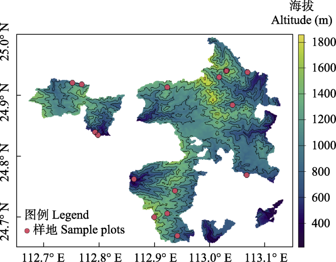
图1 广东省南岭研究区及其16个1 ha森林动态监测样地分布图
Fig. 1 The locations of the study area and 16 1-ha forest dynamics monitoring plots in the Nanling Mountains of Guangdong Province
| 样地编号 Plot ID | 海拔 Altitude (m) | 物种数 No. of species (DBH ≥ 1 cm) | 科数 No. of families | 属数 No. of genera | 总个体数 No. of individuals | 植被类型 Vegetation type | 乔木层优势种 Dominant species in tree layer |
|---|---|---|---|---|---|---|---|
| NL01 | 324 | 92 | 38 | 62 | 8,774 | 常绿针阔叶混 交林 ECBF | 马尾松 Pinus massoniana 鼠刺 Itea chinensis 油茶 Camellia oleifera |
| NL02 | 393 | 172 | 49 | 97 | 5,609 | 常绿阔叶林 EBLF | 木荷 Schima superba 西南臀果木 Prunus arborea 硬壳桂 Cryptocarya chingii |
| NL03 | 447 | 185 | 56 | 113 | 9,538 | 常绿阔叶林 EBLF | 硬壳桂 Cryptocarya chingii 鼠刺 Itea chinensis 檵木 Loropetalum chinense |
| NL04 | 600 | 229 | 54 | 110 | 6,409 | 常绿阔叶林 EBLF | 蕈树 Liquidambar chinensis 双齿山茉莉 Huodendron biaristatum 米槠 Castanopsis carlesii |
| NL05 | 850 | 197 | 52 | 96 | 5,644 | 常绿落叶阔叶混 交林 EDBF | 南酸枣 Choerospondias axillaris 贵州木瓜红 Rehderodendron kweichowense 栲 Castanopsis fargesii |
| NL06 | 861 | 188 | 52 | 104 | 8,805 | 常绿阔叶林 EBLF | 杉木 Cunninghamia lanceolata 红楠 Machilus thunbergii 枫香树 Liquidambar formosana |
| NL07 | 879 | 170 | 48 | 85 | 4,117 | 常绿阔叶林 EBLF | 赤杨叶 Alniphyllum fortunei 小叶青冈 Quercus myrsinaefolia 刺毛杜鹃 Rhododendron championiae |
| NL08 | 916 | 168 | 45 | 80 | 7,418 | 常绿落叶阔叶混 交林 EDBF | 弯蒴杜鹃 Rhododendron henryi 水青冈 Fagus longipetiolata 枫香树 Liquidambar formosana |
| NL09 | 972 | 187 | 53 | 96 | 7,167 | 常绿阔叶林 EBLF | 栲 Castanopsis fargesii 木莲 Magnolia fordiana 尖叶川杨桐 Adinandra bockiana |
| NL10 | 1,083 | 198 | 52 | 93 | 5,687 | 常绿阔叶林 EBLF | 木莲 Magnolia fordiana 罗浮锥 Castanopsis fabri 枫香树 Liquidambar formosana |
| NL11 | 1,206 | 170 | 49 | 88 | 6,313 | 常绿阔叶林 EBLF | 红楠 Machilus thunbergii 香港四照花 Cornus hongkongensis 罗浮锥 Castanopsis fabri |
| NL12 | 1,234 | 154 | 39 | 71 | 6,909 | 常绿针阔叶混 交林 ECBF | 米槠 Castanopsis carlesii 弯蒴杜鹃 Rhododendron henryi 长苞铁杉 Nothotsuga longibracteata |
| NL13 | 1,300 | 148 | 38 | 69 | 4,353 | 常绿落叶阔叶混 交林 EDBF | 黄丹木姜子 Litsea elongata 金毛柯 Lithocarpus chrysocomus 木荷 Schima superba |
| NL14 | 1,378 | 163 | 40 | 70 | 8,675 | 常绿阔叶林 EBLF | 木荷 Schima superba 枫香树 Liquidambar formosana 银钟花 Perkinsiodendron macgregorii |
| NL15 | 1,393 | 124 | 37 | 58 | 2,710 | 常绿落叶阔叶混 交林 EDBF | 厚叶红淡比 Cleyera pachyphylla 黄丹木姜子 Litsea elongata 红楠 Machilus thunbergii |
| NL16 | 1,620 | 87 | 27 | 41 | 2,795 | 常绿阔叶矮林 EBDF | 罗浮锥 Castanopsis fabri 假地枫皮 Illicium jiadifengpi 红楠 Machilus thunbergii |
表1 南岭16个1 ha亚热带森林动态监测样地特征
Table 1 The characteristics of 16 1-ha forest dynamics monitoring plots in subtropical forests in the Nanling Mountains
| 样地编号 Plot ID | 海拔 Altitude (m) | 物种数 No. of species (DBH ≥ 1 cm) | 科数 No. of families | 属数 No. of genera | 总个体数 No. of individuals | 植被类型 Vegetation type | 乔木层优势种 Dominant species in tree layer |
|---|---|---|---|---|---|---|---|
| NL01 | 324 | 92 | 38 | 62 | 8,774 | 常绿针阔叶混 交林 ECBF | 马尾松 Pinus massoniana 鼠刺 Itea chinensis 油茶 Camellia oleifera |
| NL02 | 393 | 172 | 49 | 97 | 5,609 | 常绿阔叶林 EBLF | 木荷 Schima superba 西南臀果木 Prunus arborea 硬壳桂 Cryptocarya chingii |
| NL03 | 447 | 185 | 56 | 113 | 9,538 | 常绿阔叶林 EBLF | 硬壳桂 Cryptocarya chingii 鼠刺 Itea chinensis 檵木 Loropetalum chinense |
| NL04 | 600 | 229 | 54 | 110 | 6,409 | 常绿阔叶林 EBLF | 蕈树 Liquidambar chinensis 双齿山茉莉 Huodendron biaristatum 米槠 Castanopsis carlesii |
| NL05 | 850 | 197 | 52 | 96 | 5,644 | 常绿落叶阔叶混 交林 EDBF | 南酸枣 Choerospondias axillaris 贵州木瓜红 Rehderodendron kweichowense 栲 Castanopsis fargesii |
| NL06 | 861 | 188 | 52 | 104 | 8,805 | 常绿阔叶林 EBLF | 杉木 Cunninghamia lanceolata 红楠 Machilus thunbergii 枫香树 Liquidambar formosana |
| NL07 | 879 | 170 | 48 | 85 | 4,117 | 常绿阔叶林 EBLF | 赤杨叶 Alniphyllum fortunei 小叶青冈 Quercus myrsinaefolia 刺毛杜鹃 Rhododendron championiae |
| NL08 | 916 | 168 | 45 | 80 | 7,418 | 常绿落叶阔叶混 交林 EDBF | 弯蒴杜鹃 Rhododendron henryi 水青冈 Fagus longipetiolata 枫香树 Liquidambar formosana |
| NL09 | 972 | 187 | 53 | 96 | 7,167 | 常绿阔叶林 EBLF | 栲 Castanopsis fargesii 木莲 Magnolia fordiana 尖叶川杨桐 Adinandra bockiana |
| NL10 | 1,083 | 198 | 52 | 93 | 5,687 | 常绿阔叶林 EBLF | 木莲 Magnolia fordiana 罗浮锥 Castanopsis fabri 枫香树 Liquidambar formosana |
| NL11 | 1,206 | 170 | 49 | 88 | 6,313 | 常绿阔叶林 EBLF | 红楠 Machilus thunbergii 香港四照花 Cornus hongkongensis 罗浮锥 Castanopsis fabri |
| NL12 | 1,234 | 154 | 39 | 71 | 6,909 | 常绿针阔叶混 交林 ECBF | 米槠 Castanopsis carlesii 弯蒴杜鹃 Rhododendron henryi 长苞铁杉 Nothotsuga longibracteata |
| NL13 | 1,300 | 148 | 38 | 69 | 4,353 | 常绿落叶阔叶混 交林 EDBF | 黄丹木姜子 Litsea elongata 金毛柯 Lithocarpus chrysocomus 木荷 Schima superba |
| NL14 | 1,378 | 163 | 40 | 70 | 8,675 | 常绿阔叶林 EBLF | 木荷 Schima superba 枫香树 Liquidambar formosana 银钟花 Perkinsiodendron macgregorii |
| NL15 | 1,393 | 124 | 37 | 58 | 2,710 | 常绿落叶阔叶混 交林 EDBF | 厚叶红淡比 Cleyera pachyphylla 黄丹木姜子 Litsea elongata 红楠 Machilus thunbergii |
| NL16 | 1,620 | 87 | 27 | 41 | 2,795 | 常绿阔叶矮林 EBDF | 罗浮锥 Castanopsis fabri 假地枫皮 Illicium jiadifengpi 红楠 Machilus thunbergii |
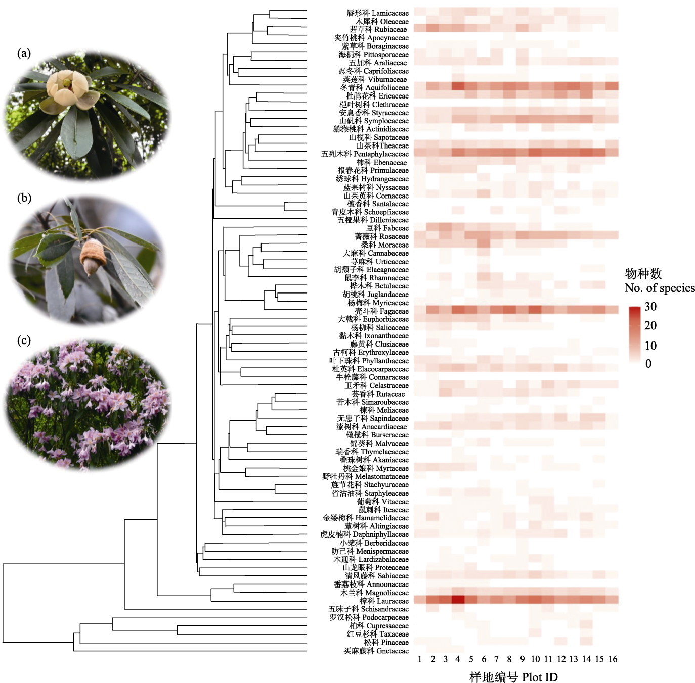
图2 582个物种所属的78个科在16个1 ha样地的系统发育分布与丰富度。图中展示了研究区内3个代表种的图片: (a)厚叶木莲(木兰科); (b)小叶青冈(壳斗科); (c)弯蒴杜鹃(杜鹃花科)。进化树末端标注了科名与拉丁名; 右侧色阶矩阵代表每个科在相应样地的物种丰富度。
Fig. 2 Phylogenetic placement and species richness of 78 families for 582 species in 16 1-ha plots. Photographs show three representative species in the study area: (a) Manglietia pachyphylla (Magnoliaceae); (b) Quercus myrsinifolia (Fagaceae); (c) Rhododendron henryi (Ericaceae). Family names in both Chinese and Latin are labeled at the tips of the phylogenetic tree. The color gradient matrix on the right indicates the species richness of each family within the corresponding plots.
| 代码 Code | 分布类型 Areal type | 属数 No. of genera (%) | 物种数 No. of species (%) |
|---|---|---|---|
| 1 | 世界分布 Cosmopolitan | 3 (1.36) | 10 (1.72) |
| 2 | 泛热带分布 Pantropic | 42 (19.09) | 135 (23.20) |
| 3 | 东亚及热带美洲间断分布 Tropical Asia and Tropical America disjunction | 16 (7.27) | 106 (18.21) |
| 4 | 旧世界热带分布 Old World Tropic | 14 (6.36) | 30 (5.15) |
| 5 | 热带亚洲至热带大洋洲分布 Tropical Asia to Tropical Australia | 17 (7.73) | 30 (5.15) |
| 6 | 热带亚洲至热带非洲分布 Tropical Asia to Tropical Africa | 8 (3.64) | 16 (2.75) |
| 7 | 热带亚洲分布 Tropical Asia | 40 (18.18) | 81 (13.92) |
| 热带成分小计(分布型2‒7) Subtotal in tropical elements (Types 2‒7) | 137 (62.27) | 398 (68.38) | |
| 8 | 北温带分布 North Temperate | 26 (11.82) | 78 (13.40) |
| 9 | 东亚及北美间断分布 East Asia and North America disjunction | 22 (10) | 51 (8.76) |
| 10 | 旧世界温带分布 Old World Temperate | 3 (1.36) | 5 (0.86) |
| 11 | 温带亚洲分布 Temperate Asia | 0 (0) | 0 (0) |
| 12 | 地中海、西亚至中亚分布 Mediterranean, West Asia to Center Asia | 2 (0.91) | 2 (0.34) |
| 13 | 中亚分布 Central Asia | 0 (0) | 0 (0) |
| 14 | 东亚分布 East Asia | 20 (9.09) | 31 (5.33) |
| 15 | 中国特有分布 Endemic to China | 7 (3.18) | 7 (1.20) |
| 温带成分小计(分布型8‒15) Subtotal in temperate elements (Types 8‒15) | 80 (36.36) | 174 (29.90) | |
| 总计 Total | 220 (100) | 582 (100) | |
表2 南岭16个1 ha样地种子植物属的分布类型
Table 2 Areal types for the genera of seed plants in 16 1-ha plots in the Nanling Mountains
| 代码 Code | 分布类型 Areal type | 属数 No. of genera (%) | 物种数 No. of species (%) |
|---|---|---|---|
| 1 | 世界分布 Cosmopolitan | 3 (1.36) | 10 (1.72) |
| 2 | 泛热带分布 Pantropic | 42 (19.09) | 135 (23.20) |
| 3 | 东亚及热带美洲间断分布 Tropical Asia and Tropical America disjunction | 16 (7.27) | 106 (18.21) |
| 4 | 旧世界热带分布 Old World Tropic | 14 (6.36) | 30 (5.15) |
| 5 | 热带亚洲至热带大洋洲分布 Tropical Asia to Tropical Australia | 17 (7.73) | 30 (5.15) |
| 6 | 热带亚洲至热带非洲分布 Tropical Asia to Tropical Africa | 8 (3.64) | 16 (2.75) |
| 7 | 热带亚洲分布 Tropical Asia | 40 (18.18) | 81 (13.92) |
| 热带成分小计(分布型2‒7) Subtotal in tropical elements (Types 2‒7) | 137 (62.27) | 398 (68.38) | |
| 8 | 北温带分布 North Temperate | 26 (11.82) | 78 (13.40) |
| 9 | 东亚及北美间断分布 East Asia and North America disjunction | 22 (10) | 51 (8.76) |
| 10 | 旧世界温带分布 Old World Temperate | 3 (1.36) | 5 (0.86) |
| 11 | 温带亚洲分布 Temperate Asia | 0 (0) | 0 (0) |
| 12 | 地中海、西亚至中亚分布 Mediterranean, West Asia to Center Asia | 2 (0.91) | 2 (0.34) |
| 13 | 中亚分布 Central Asia | 0 (0) | 0 (0) |
| 14 | 东亚分布 East Asia | 20 (9.09) | 31 (5.33) |
| 15 | 中国特有分布 Endemic to China | 7 (3.18) | 7 (1.20) |
| 温带成分小计(分布型8‒15) Subtotal in temperate elements (Types 8‒15) | 80 (36.36) | 174 (29.90) | |
| 总计 Total | 220 (100) | 582 (100) | |
| 样地 编号 Plot ID | 木荷 Schima superba | 红楠 Machilus thunbergii | 罗浮锥 Castanopsis fabri | 马尾松 Pinus massoniana | 木莲 Magnolia fordiana | 赤杨叶 Alniphyllum fortunei | 米槠 Castanopsis carlesii | 黄丹木姜子 Litsea elongata | 枫香树 Liquidambar formosana | 鼠刺 Itea chinensis |
|---|---|---|---|---|---|---|---|---|---|---|
| NL01 | 55 (1.71) | 0 (0.00) | 0 (0.00) | 341 (34.10) | 0 (0.00) | 36 (3.11) | 1 (0.00) | 2 (0.15) | 13 (1.68) | 4,074 (19.23) |
| NL02 | 574 (17.04) | 0 (0.00) | 5 (0.12) | 5 (0.68) | 0 (0.00) | 34 (2.55) | 0 (0.00) | 9 (0.18) | 22 (1.81) | 200 (2.00) |
| NL03 | 93 (3.99) | 1 (0.00) | 2 (0.00) | 4 (0.28) | 1 (0.00) | 66 (6.31) | 6 (0.09) | 94 (0.57) | 3 (0.61) | 1,222 (7.47) |
| NL04 | 6 (0.23) | 2 (0.14) | 40 (1.59) | 0 (0.00) | 20 (1.11) | 2 (0.08) | 486 (7.45) | 140 (1.62) | 0 (0.00) | 105 (0.74) |
| NL05 | 31 (0.86) | 32 (0.64) | 29 (0.88) | 0 (0.00) | 186 (4.32) | 20 (1.32) | 7 (0.31) | 251 (2.26) | 0 (0.00) | 206 (0.33) |
| NL06 | 4 (0.11) | 658 (14.03) | 3 (0.17) | 0 (0.00) | 13 (0.31) | 42 (1.67) | 7 (0.17) | 30 (0.32) | 96 (5.69) | 2 (0.00) |
| NL07 | 8 (0.17) | 55 (1.95) | 66 (2.19) | 15 (3.45) | 130 (3.04) | 88 (4.83) | 33 (2.17) | 48 (0.57) | 0 (0.00) | 9 (0.15) |
| NL08 | 112 (3.39) | 125 (2.01) | 176 (3.45) | 4 (0.12) | 82 (1.27) | 161 (4.12) | 0 (0.00) | 154 (1.38) | 153 (5.03) | 54 (0.12) |
| NL09 | 103 (1.03) | 173 (2.34) | 209 (2.97) | 15 (3.12) | 283 (4.72) | 119 (2.97) | 0 (0.00) | 310 (3.22) | 0 (0.00) | 0 (0.00) |
| NL10 | 50 (1.10) | 253 (3.32) | 208 (4.94) | 0 (0.00) | 303 (11.81) | 67 (3.85) | 0 (0.00) | 373 (2.25) | 43 (4.12) | 5 (0.00) |
| NL11 | 3 (0.20) | 532 (14.19) | 147 (7.05) | 0 (0.00) | 204 (4.27) | 27 (1.37) | 140 (4.70) | 152 (2.48) | 0 (0.00) | 11 (0.06) |
| NL12 | 73 (2.13) | 313 (5.52) | 125 (4.18) | 40 (3.15) | 35 (0.85) | 62 (3.29) | 618 (21.03) | 119 (1.08) | 0 (0.00) | 13 (0.08) |
| NL13 | 105 (6.26) | 28 (2.03) | 27 (0.91) | 0 (0.00) | 35 (0.60) | 0 (0.00) | 42 (1.83) | 263 (7.11) | 0 (0.00) | 14 (0.27) |
| NL14 | 1,358 (36.23) | 188 (2.06) | 2 (0.00) | 49 (3.53) | 94 (1.38) | 41 (1.11) | 0 (0.00) | 79 (0.35) | 339 (7.54) | 26 (0.08) |
| NL15 | 18 (2.94) | 100 (4.76) | 14 (1.91) | 0 (0.00) | 43 (3.26) | 0 (0.00) | 4 (0.12) | 278 (6.05) | 12 (2.49) | 11 (0.00) |
| NL16 | 1 (0.11) | 94 (9.73) | 117 (14.74) | 0 (0.00) | 39 (2.92) | 0 (0.00) | 0 (0.00) | 3 (0.26) | 0 (0.00) | 1 (0.00) |
表3 南岭16个1 ha样地10个代表树种在各样地的个体数与重要值(%)
Table 3 The number of individuals and importance value (%) of 10 selected tree species in 16 1-ha plots in the Nanling Mountains
| 样地 编号 Plot ID | 木荷 Schima superba | 红楠 Machilus thunbergii | 罗浮锥 Castanopsis fabri | 马尾松 Pinus massoniana | 木莲 Magnolia fordiana | 赤杨叶 Alniphyllum fortunei | 米槠 Castanopsis carlesii | 黄丹木姜子 Litsea elongata | 枫香树 Liquidambar formosana | 鼠刺 Itea chinensis |
|---|---|---|---|---|---|---|---|---|---|---|
| NL01 | 55 (1.71) | 0 (0.00) | 0 (0.00) | 341 (34.10) | 0 (0.00) | 36 (3.11) | 1 (0.00) | 2 (0.15) | 13 (1.68) | 4,074 (19.23) |
| NL02 | 574 (17.04) | 0 (0.00) | 5 (0.12) | 5 (0.68) | 0 (0.00) | 34 (2.55) | 0 (0.00) | 9 (0.18) | 22 (1.81) | 200 (2.00) |
| NL03 | 93 (3.99) | 1 (0.00) | 2 (0.00) | 4 (0.28) | 1 (0.00) | 66 (6.31) | 6 (0.09) | 94 (0.57) | 3 (0.61) | 1,222 (7.47) |
| NL04 | 6 (0.23) | 2 (0.14) | 40 (1.59) | 0 (0.00) | 20 (1.11) | 2 (0.08) | 486 (7.45) | 140 (1.62) | 0 (0.00) | 105 (0.74) |
| NL05 | 31 (0.86) | 32 (0.64) | 29 (0.88) | 0 (0.00) | 186 (4.32) | 20 (1.32) | 7 (0.31) | 251 (2.26) | 0 (0.00) | 206 (0.33) |
| NL06 | 4 (0.11) | 658 (14.03) | 3 (0.17) | 0 (0.00) | 13 (0.31) | 42 (1.67) | 7 (0.17) | 30 (0.32) | 96 (5.69) | 2 (0.00) |
| NL07 | 8 (0.17) | 55 (1.95) | 66 (2.19) | 15 (3.45) | 130 (3.04) | 88 (4.83) | 33 (2.17) | 48 (0.57) | 0 (0.00) | 9 (0.15) |
| NL08 | 112 (3.39) | 125 (2.01) | 176 (3.45) | 4 (0.12) | 82 (1.27) | 161 (4.12) | 0 (0.00) | 154 (1.38) | 153 (5.03) | 54 (0.12) |
| NL09 | 103 (1.03) | 173 (2.34) | 209 (2.97) | 15 (3.12) | 283 (4.72) | 119 (2.97) | 0 (0.00) | 310 (3.22) | 0 (0.00) | 0 (0.00) |
| NL10 | 50 (1.10) | 253 (3.32) | 208 (4.94) | 0 (0.00) | 303 (11.81) | 67 (3.85) | 0 (0.00) | 373 (2.25) | 43 (4.12) | 5 (0.00) |
| NL11 | 3 (0.20) | 532 (14.19) | 147 (7.05) | 0 (0.00) | 204 (4.27) | 27 (1.37) | 140 (4.70) | 152 (2.48) | 0 (0.00) | 11 (0.06) |
| NL12 | 73 (2.13) | 313 (5.52) | 125 (4.18) | 40 (3.15) | 35 (0.85) | 62 (3.29) | 618 (21.03) | 119 (1.08) | 0 (0.00) | 13 (0.08) |
| NL13 | 105 (6.26) | 28 (2.03) | 27 (0.91) | 0 (0.00) | 35 (0.60) | 0 (0.00) | 42 (1.83) | 263 (7.11) | 0 (0.00) | 14 (0.27) |
| NL14 | 1,358 (36.23) | 188 (2.06) | 2 (0.00) | 49 (3.53) | 94 (1.38) | 41 (1.11) | 0 (0.00) | 79 (0.35) | 339 (7.54) | 26 (0.08) |
| NL15 | 18 (2.94) | 100 (4.76) | 14 (1.91) | 0 (0.00) | 43 (3.26) | 0 (0.00) | 4 (0.12) | 278 (6.05) | 12 (2.49) | 11 (0.00) |
| NL16 | 1 (0.11) | 94 (9.73) | 117 (14.74) | 0 (0.00) | 39 (2.92) | 0 (0.00) | 0 (0.00) | 3 (0.26) | 0 (0.00) | 1 (0.00) |
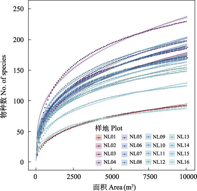
图3 南岭16个1 ha样地木本植物的种-面积曲线
Fig. 3 Species‒area relationship of woody plants in 16 1-ha plots in the Nanling Mountains
| 样地编号 Plot ID | 物种数占比 Percentage of species richness | |||||||
|---|---|---|---|---|---|---|---|---|
| 20% | 30% | 40% | 50% | 60% | 70% | 80% | 90% | |
| NL01 | 220 | 467 | 830 | 1,386 | 2,167 | 3,218 | 4,936 | 7,052 |
| NL02 | 247 | 468 | 802 | 1,260 | 1,910 | 2,932 | 4,534 | 6,719 |
| NL03 | 184 | 365 | 665 | 1,110 | 1,746 | 2,778 | 4,313 | 6,564 |
| NL04 | 199 | 379 | 649 | 1,052 | 1,685 | 2,627 | 4,221 | 6,554 |
| NL05 | 236 | 455 | 804 | 1,322 | 2,044 | 3,099 | 4,650 | 6,939 |
| NL06 | 208 | 414 | 737 | 1,253 | 2,070 | 3,263 | 4,915 | 7,040 |
| NL07 | 207 | 386 | 659 | 1,103 | 1,722 | 2,665 | 4,135 | 6,437 |
| NL08 | 177 | 341 | 595 | 1,023 | 1,640 | 2,543 | 3,916 | 6,188 |
| NL09 | 185 | 370 | 658 | 1,155 | 1,933 | 3,109 | 4,746 | 7,057 |
| NL10 | 194 | 362 | 619 | 1,020 | 1,644 | 2,622 | 4,077 | 6,305 |
| NL11 | 214 | 418 | 682 | 1,087 | 1,666 | 2,601 | 3,938 | 6,218 |
| NL12 | 188 | 379 | 655 | 1,112 | 1,824 | 2,925 | 4,436 | 6,767 |
| NL13 | 166 | 312 | 545 | 912 | 1,485 | 2,454 | 4,017 | 6,407 |
| NL14 | 195 | 399 | 706 | 1,145 | 1,813 | 2,843 | 4,373 | 6,649 |
| NL15 | 217 | 391 | 663 | 1,083 | 1,696 | 2,627 | 4,100 | 6,280 |
| NL16 | 201 | 398 | 697 | 1,135 | 1,737 | 2,608 | 4,135 | 6,405 |
| 平均面积 Mean area (m2) | 202 | 394 | 685 | 1,135 | 1,799 | 2,807 | 4,340 | 6,599 |
表4 南岭16个样地物种累积百分比与取样面积(m2)的关系
Table 4 Relationship between the cumulative species percentage and sampling plot size (m2) in 16 1-ha plots in the Nanling Mountains
| 样地编号 Plot ID | 物种数占比 Percentage of species richness | |||||||
|---|---|---|---|---|---|---|---|---|
| 20% | 30% | 40% | 50% | 60% | 70% | 80% | 90% | |
| NL01 | 220 | 467 | 830 | 1,386 | 2,167 | 3,218 | 4,936 | 7,052 |
| NL02 | 247 | 468 | 802 | 1,260 | 1,910 | 2,932 | 4,534 | 6,719 |
| NL03 | 184 | 365 | 665 | 1,110 | 1,746 | 2,778 | 4,313 | 6,564 |
| NL04 | 199 | 379 | 649 | 1,052 | 1,685 | 2,627 | 4,221 | 6,554 |
| NL05 | 236 | 455 | 804 | 1,322 | 2,044 | 3,099 | 4,650 | 6,939 |
| NL06 | 208 | 414 | 737 | 1,253 | 2,070 | 3,263 | 4,915 | 7,040 |
| NL07 | 207 | 386 | 659 | 1,103 | 1,722 | 2,665 | 4,135 | 6,437 |
| NL08 | 177 | 341 | 595 | 1,023 | 1,640 | 2,543 | 3,916 | 6,188 |
| NL09 | 185 | 370 | 658 | 1,155 | 1,933 | 3,109 | 4,746 | 7,057 |
| NL10 | 194 | 362 | 619 | 1,020 | 1,644 | 2,622 | 4,077 | 6,305 |
| NL11 | 214 | 418 | 682 | 1,087 | 1,666 | 2,601 | 3,938 | 6,218 |
| NL12 | 188 | 379 | 655 | 1,112 | 1,824 | 2,925 | 4,436 | 6,767 |
| NL13 | 166 | 312 | 545 | 912 | 1,485 | 2,454 | 4,017 | 6,407 |
| NL14 | 195 | 399 | 706 | 1,145 | 1,813 | 2,843 | 4,373 | 6,649 |
| NL15 | 217 | 391 | 663 | 1,083 | 1,696 | 2,627 | 4,100 | 6,280 |
| NL16 | 201 | 398 | 697 | 1,135 | 1,737 | 2,608 | 4,135 | 6,405 |
| 平均面积 Mean area (m2) | 202 | 394 | 685 | 1,135 | 1,799 | 2,807 | 4,340 | 6,599 |
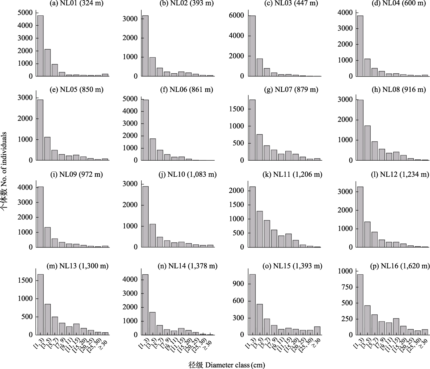
图4 南岭16个1 ha样地木本植物径级分布图
Fig. 4 Diameter-class distributions of woody plants in 16 1-ha plots in the Nanling Mountains

图5 木荷在样地NL02 (a-b)和NL14 (c-d)的空间分布与径级结构
Fig. 5 Spatial distribution and diameter-class structure of Schima superba in the two plots NL02 (a‒b) and NL14 (c‒d)
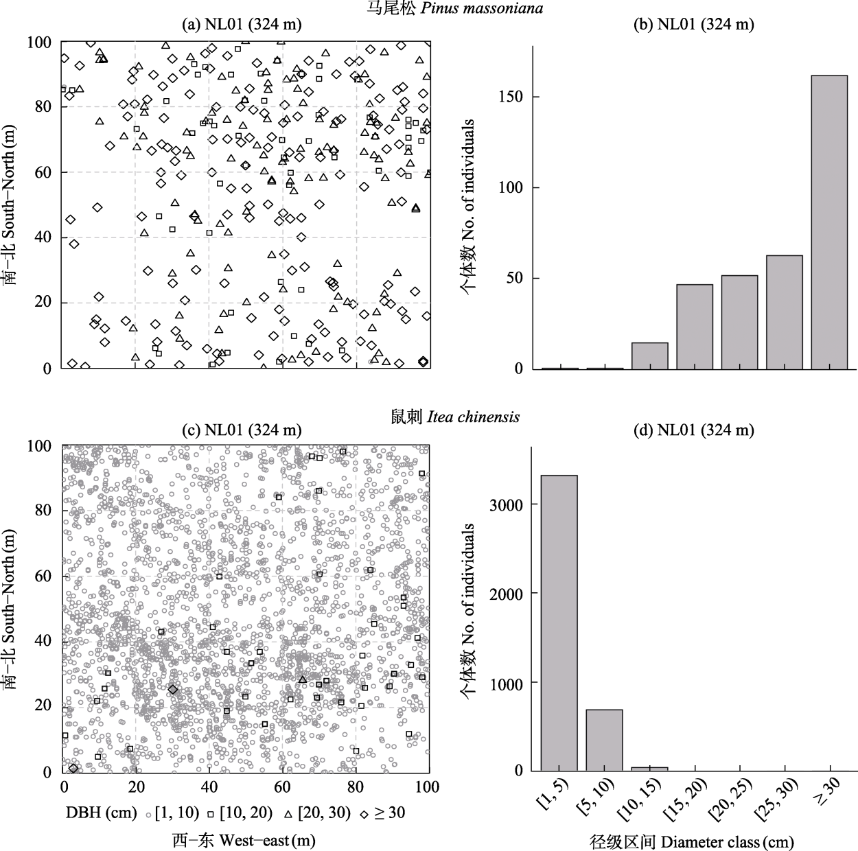
图6 马尾松(a‒b)、鼠刺(c‒d)在样地NL01的空间分布与径级结构
Fig. 6 Spatial distribution and diameter-class structure of Pinus massoniana (a‒b) and Itea chinensis (c‒d) in the plot NL01
| [1] | Cao HL, Wu LF, Wang ZG, Huang ZL, Li L, Wei SG, Lian JY, Ye WH (2013) Dinghushan Lower Subtropical Forest Dynamics Plot:Tree Species and Their Distribution Patterns. China Forestry Publishing House, Beijing. (in Chinese) |
| [曹洪麟, 吴林芳, 王志高, 黄忠良, 李林, 魏识广, 练琚愉, 叶万辉 (2013) 鼎湖山南亚热带森林——树种及其分布格局. 中国林业出版社, 北京.] | |
| [2] | Chen BG, Su ZY, Li ZK (1997) Structural characteristics of montane broadleaved evergreen forest on Mount Tianjingshan, Guangdong. Journal of South China Agricultural University, 18(3), 45-50. (in Chinese with English abstract) |
| [陈北光, 苏志尧, 李镇魁 (1997) 广东天井山山地常绿阔叶林的结构特征. 华南农业大学学报, 18(3), 45-50.] | |
| [3] | Chen HF, Deng SW (2024) Inventory of Vascular Plants Diversity of Nanling Mountains. Huazhong University of Science and Technology Press, Wuhan. (in Chinese) |
| [陈红锋, 邓双文 (2024) 南岭山地维管植物多样性编目. 华中科技大学出版社, 武汉.] | |
| [4] | Chen LZ (1993) Biodiversity in China:Current Status and Conservation Strategies. Science Press, Beijing. (in Chinese) |
| [陈灵芝 (1993) 中国的生物多样性——现状及其保护对策. 科学出版社, 北京.] | |
| [5] | Chen T, Zhang HD (1994) Study on the floristic geography of Nanling. I. Composition and characteristics of flora. Journal of Tropical and Subtropical Botany, 2, 10-23. (in Chinese with English abstract) |
| [陈涛, 张宏达 (1994) 南岭植物区系地理学研究. I. 植物区系的组成和特点. 热带亚热带植物学报, 2, 10-23.] | |
| [6] | Chen T, Zhang HD (1996) Study on the floristic geography of Nanling. II. Analysis of seed plant flora. Sun Yat-sen University Forum, 2, 102-109. (in Chinese with English abstract) |
| [陈涛, 张宏达 (1996) 南岭植物区系地理学研究. Ⅱ. 种子植物区系分析. 中山大学学报论丛, 2, 102-109.] | |
| [7] | Condit R (1998) Tropical Forest Census Plots: Methods and Results from Barro Colorado Island, Panama and a Comparison with Other Plots. Springer-Verlag, Berlin. |
| [8] |
Condit R, Ashton PS, Baker P, Bunyavejchewin S, Gunatilleke S, Gunatilleke N, Hubbell SP, Foster RB, Itoh A, LaFrankie JV, Lee HS, Losos E, Manokaran N, Sukumar R, Yamakura T (2000) Spatial patterns in the distribution of tropical tree species. Science, 288, 1414-1418.
DOI PMID |
| [9] |
Drakare S, Lennon JJ, Hillebrand H (2006) The imprint of the geographical, evolutionary and ecological context on species-area relationships. Ecology Letters, 9, 215-227.
DOI PMID |
| [10] | Gu YK, Chen BG, Su ZY, Xie ZS, Ouyang XG, Chen S (2003) Study on dynamics of main forest types in Guangdong Nanling National Nature Reserve. In: Biodiversity Research of Guangdong Nanling National Nature Reserve (ed. Pang XF), pp.286-304. Guangdong Science and Technology Press, Guangzhou. (in Chinese) |
| [古炎坤, 陈北光, 苏志尧, 谢正生, 欧阳学工, 陈苏 (2003) 广东南岭国家级自然保护区主要森林类型动态的研究. 见: 广东南岭国家级自然保护区生物多样性研究(庞雄飞主编), 286-304页. 广东科技出版社, 广州.] | |
| [11] | Guangdong Forest Editorial Committee (1990) Guangdong Forest. Guangdong Science and Technology Press, Guangzhou & China Forestry Publishing House, Beijing. (in Chinese) |
| [广东森林编辑委员会 (1990) 广东森林. 广东科技出版社, 广州 & 中国林业出版社, 北京.] | |
| [12] | Guangdong Institute of Botany (1976) Guangdong Vegetation. Science Press, Beijing. (in Chinese) |
| [广东省植物研究所 (1976) 广东植被. 科学出版社, 北京.] | |
| [13] |
Harrison S, Grace JB (2007) Biogeographic affinity helps explain productivity-richness relationships at regional and local scales. The American Naturalist, 170, S5-S15.
DOI URL |
| [14] |
Jin Y, Qian H (2023) U.PhyloMaker: An R package that can generate large phylogenetic trees for plants and animals. Plant Diversity, 45, 347-352.
DOI |
| [15] | Li BH, Wu ZH, Bin Y, Xiao RG, Song XJ, Shu ZF, Chu CJ (2020) Chebaling Mid-Subtropical Evergreen Broad-Leaved Forest Dynamics Plot:Species Composition and Community Structure. Guangdong Science and Technology Press, Guangzhou. (in Chinese) |
| [李步杭, 吴智宏, 宾粤, 肖荣高, 宋相金, 束祖飞, 储诚进 (2020) 车八岭中亚热带常绿阔叶林监测样地——物种组成与群落结构. 广东科技出版社, 广州.] | |
| [16] | Li DZ, Chen ZD, Wang H, Lu AM, Luo Y, Yu WB (2018) Flora of China:Families and Genera of Vascular Plants. Science Press, Beijing. (in Chinese) |
| [李德铢, 陈之端, 王红, 路安民, 骆洋, 郁文彬 (2018) 中国维管植物科属志. 科学出版社, 北京.] | |
| [17] |
Li YZ, Jiang Y, Shipley B, Li BH, Luo WQ, Chen YF, Zhao KN, He D, Rodríguez-Hernández DI, Chu CJ (2021) The complexity of trait-environment performance landscapes in a local subtropical forest. New Phytologist, 229, 1388-1397.
DOI PMID |
| [18] | Lin Y (1965) On the nature of vegetation in the Nanling Mountains and its position in China’s vegetation regionalization. Acta Phytoecologica et Geobotanica Sinica, 3, 50-74. (in Chinese) |
| [林英 (1965) 论南岭山地植被的性质及其在中国植被区划中的位置问题. 植物生态学与地植物学丛刊, 3, 50-74.] | |
| [19] |
Lyons SK, Willig MR (2002) Species richness, latitude, and scale-sensitivity. Ecology, 83, 47-58.
DOI URL |
| [20] |
Palmer MW, White PS (1994) Scale dependence and the species- area relationship. The American Naturalist, 144, 717-740.
DOI URL |
| [21] | Pang XF, Zhuang XY, Tian MY, Pang H (2003) Nanling and Lingnan:Megabiodiversity hotspots. In: Research on Biodiversity of Guangdong Nanling National Nature Reserve (ed. Pang XF), pp.28-64. Guangdong Science and Technology Press, Guangzhou. (in Chinese) |
| [庞雄飞, 庄雪影, 田明义, 庞虹 (2003) 南岭和岭南——生物多样性特丰产地. 见: 广东南岭国家级自然保护区生物多样性研究(庞雄飞主编), 28-64页. 广东科技出版社, 广州.] | |
| [22] | Qi CJ, Xiao YT, Cao TR, Lin QZ (1992) Study on vegetation of Nanling Mountains. Journal of Central South University of Forestry and Technology, 12, 1-10. (in Chinese with English abstract) |
| [祁承经, 萧育檀, 曹铁如, 林亲众 (1992) 南岭植被的研究. 中南林学院学报, 12, 1-10.] | |
| [23] | R Core Team (2024) R: A Language and Environment for Statistical Computing. R Foundation for Statistical Computing, Vienna. |
| [24] |
Radomski T (2026) The ecology of geographic range limits. Biological Reviews, 101, 39-59.
DOI URL |
| [25] |
Shen GC, He FL, Waagepetersen R, Sun IF, Hao ZQ, Chen ZS, Yu MJ (2013) Quantifying effects of habitat heterogeneity and other clustering processes on spatial distributions of tree species. Ecology, 94, 2436-2443.
PMID |
| [26] | Shen Y, Gong YN, Mei QM, Liu ZF, Wu LF, Zhang Q (2024) Subtropical Forests of Guangdong Nanling:Tree Species and Distribution Patterns. China Forestry Publishing House, Beijing. (in Chinese) |
| [沈勇, 龚粤宁, 梅启明, 刘志发, 吴林芳, 张强 (2024) 广东南岭亚热带森林——树种及其分布格局. 中国林业出版社, 北京.] | |
| [27] | Song YC (2016) Vegetation Ecology, 2nd edn. Higher Education Press, Beijing. (in Chinese) |
| [宋永昌 (2016) 植被生态学(第二版). 高等教育出版社, 北京.] | |
| [28] |
Song YC, Yan ER, Song K (2015) Synthetic comparison of eight dynamics plots in evergreen broadleaf forests, China. Biodiversity Science, 23, 139-148. (in Chinese with English abstract)
DOI |
|
[宋永昌, 阎恩荣, 宋坤 (2015) 中国常绿阔叶林八大动态监测样地植被的综合比较. 生物多样性, 23, 139-148.]
DOI |
|
| [29] | Su ZY, Chen BG, Gu YK (1995) Floristic composition and structural characteristics of forest communities in Babaoshan Nature Reserve, North Guangdong. Guihaia, 15, 124-130. (in Chinese with English abstract) |
| [苏志尧, 陈北光, 古炎坤 (1995) 粤北八宝山森林群落的组成和结构特征. 广西植物, 15, 124-130.] | |
| [30] | Vellend M (2016) The Theory of Ecological Communities. Princeton University Press, Princeton, NJ. |
| [31] | Vellend M (translated by Zhang J, Zhang ZC, Wang YZ, Liu XY, Song HJ, Gao ZW, Wang X, Zhang R (2020) The Theory of Ecological Communities. Higher Education Press, Beijing. (in Chinese) |
| [张健, 张昭臣, 王宇卓, 刘翔宇, 宋厚娟, 高志文, 王昕, 张然(译)(2020) 生态群落理论. 高等教育出版社, 北京.] | |
| [32] | Wang FG, Chen ZM, Chen HF, Xing FW, Dong AQ (2013) Flora and Vegetation of Nanling National Nature Reserve. Huazhong University of Science and Technology Press, Wuhan. (in Chinese) |
| [王发国, 陈振明, 陈红锋, 邢福武, 董安强 (2013) 南岭国家级自然保护区植物区系与植被. 华中科技大学出版社, 武汉.] | |
| [33] | WFO (World Flora Online Consortium) (2024) World Flora Online. http://www.worldfloraonline.org. (accessed on 2024-06-14) |
| [34] |
Wiegand T, Wang XG, Fischer SM, Kraft NJB, Bourg NA, Brockelman WY, Cao GH, Cao M, Chanthorn W, Chu CJ, Davies S, Ediriweera S, Gunatilleke CSV, Gunatilleke IAUN, Hao ZQ, Howe R, Jiang MX, Jin GZ, Kress WJ, Li BH, Lian JY, Lin LX, Liu F, Ma KP, McShea W, Mi XC, Myers JA, Nathalang A, Orwig DA, Shen GC, Su SH, Sun IF, Wang XH, Wolf A, Yan ER, Ye WH, Zhu Y, Huth A (2025) Latitudinal scaling of aggregation with abundance and coexistence in forests. Nature, 640, 967-973.
DOI |
| [35] | Wu ZY, Raven PH, Hong DY (1994-2013) (1994-2013) Flora of China (Vols. 1-25). Science Press, Beijing & Missouri Botanical Garden Press, St. Louis. |
| [36] | Wu ZY, Sun H, Zhou ZK, Li DZ, Peng H (2011) Floristic Geography of Seed Plants in China. Science Press, Beijing. (in Chinese) |
| [吴征镒, 孙航, 周浙昆, 李德铢, 彭华 (2011) 中国种子植物区系地理. 科学出版社, 北京.] | |
| [37] | Xie ZS, Gu YK, Chen BG, Su ZY (2003) Species diversity of the natural forest communities in Nanling National Nature Reserve, Guangdong. In: Biodiversity Research of Guangdong Nanling National Nature Reserve (ed. Pang XF), pp.305-311. Guangdong Science and Technology Press, Guangzhou. (in Chinese) |
| [谢正生, 古炎坤, 陈北光, 苏志尧 (2003) 广东南岭国家级自然保护区森林群落物种多样性分析. 见: 广东南岭国家级自然保护区生物多样性研究(庞雄飞主编), 305-311页. 广东科技出版社, 广州.] | |
| [38] | Xu YQ (1993) The significance of establishing Nanling National Nature Reserve. Ecological Science, 13, 14-20. (in Chinese with English abstract) |
| [徐燕千 (1993) 建立南岭国家级自然保护区的重大意义. 生态科学, 13, 14-20.] | |
| [39] | Ye WH, Cao HL, Huang ZL, Lian JY, Wang ZG, Li L, Wei SG, Wang ZM (2008) Effects of vertical stratification on community structure and functions in a subtropical, evergreen broad-leaved forest in the Dinghushan National Nature Reserve. Journal of Plant Ecology (Chinese Version), 32, 274-286. (in Chinese with English abstract) |
|
[叶万辉, 曹洪麟, 黄忠良, 练琚愉, 王志高, 李林, 魏识广, 王章明 (2008) 鼎湖山南亚热带常绿阔叶林20公顷样地群落特征研究. 植物生态学报, 32, 274-286.]
DOI |
|
| [40] |
Zanne AE, Tank DC, Cornwell WK, Eastman JM, Smith SA, FitzJohn RG, McGlinn DJ, O’Meara BC, Moles AT, Reich PB, Royer DL, Soltis DE, Stevens PF, Westoby M, Wright IJ, Aarssen L, Bertin RI, Calaminus A, Govaerts R, Hemmings F, Leishman MR, Oleksyn J, Soltis PS, Swenson NG, Warman L, Beaulieu JM (2014) Three keys to the radiation of angiosperms into freezing environments. Nature, 506, 89-92.
DOI |
| [41] | Zhang HD (2003) Study on the seed plant flora of Nanling Mountains. In: Research on Biodiversity of Guangdong Nanling National Nature Reserve (ed. Pang XF), pp.98-123. Guangdong Science and Technology Press, Guangzhou. (in Chinese) |
| [张宏达 (2003) 南岭山地的种子植物区系研究. 见: 广东南岭国家级自然保护区生物多样性研究(庞雄飞主编), 98-123页. 广东科技出版社, 广州.] | |
| [42] |
Zhang J, Qian H (2023) U.Taxonstand: An R package for standardizing scientific names of plants and animals. Plant Diversity, 45, 1-5.
DOI |
| [43] |
Zhang J, Qian H, Wang XY (2025) An online version and some updates of R package U.Taxonstand for standardizing scientific names in plant and animal species. Plant Diversity, 47, 166-168.
DOI |
| [44] | Zhang JQ (1993) Vegetation characteristics of Babao Mountain Nature Reserve in Ruyang, Guangdong. Ecological Science, 1, 39-124. (in Chinese with English abstract) |
| [张金泉 (1993) 广东乳阳八宝山自然保护区的植被特点. 生态科学, 1, 39-124.] | |
| [45] |
Zhang ZC, Wang F, Wang XR, Sun MF, Zheng P, Zhao JC, Chen JH, Guan M, Liu PG, Shang XF, Lu YS, Yang QP, Song QN, Chen L, Zhong QY, Zhang J (2025) Biogeographic affinity partly shapes woody plant diversity along an elevational gradient in subtropical forests. Plant Diversity, 47, 784-792.
DOI PMID |
| [46] | Zhou GY, Zhang HO, Zhou P (2018) Multidisciplinary comprehensive research value of Nanling Mountains. Tropical Geography, 38, 293-298. (in Chinese with English abstract) |
| [周国逸, 张虹鸥, 周平 (2018) 南岭山地的多学科综合研究价值. 热带地理, 38, 293-298.] |
| [1] | 梁健超, 陈淑甜, 何文祥, 熊春妮, 许镇洲, 黄源欣, 刘源志弘, 张浪, 胡慧建. 广州市陆生野生脊椎动物资源——编目、分布与保护[J]. 生物多样性, 2026, 34(5): 25422-. |
| [2] | 黄语卓, 王梓潆, 周伟龙, 莫佳瑶, 张敏华, 郝春晖, 兰荣光, 叶沛阳, 刘宇. 浙江省百山祖25 ha亚热带森林动态监测样地木本植物叶片虫食强度分布格局及其影响因素[J]. 生物多样性, 2026, 34(4): 25406-. |
| [3] | 夏东坡, 李静, 田军东, 黄中豪, 伍乘风, 陈仕望, 李进华. 中国野生猕猴属动物的研究进展[J]. 生物多样性, 2026, 34(3): 25460-. |
| [4] | 周婷婷, 张浩淼, 王浩杰, 廖健, 陈晓丹, 杨楠, 韩博平, 刘振元. 广东省蜻蜓目物种多样性空间格局及关键影响因素[J]. 生物多样性, 2026, 34(2): 25337-. |
| [5] | 罗熙, 王啟芳, 王建佳, 杨倩曦, 方鸿飞, 洪淼, 张琦, 蔡灵, 周曦杰, 黄丁勇, 郑新庆. 福建东山海域新记录种揭示我国北缘造礁石珊瑚群落多样性[J]. 生物多样性, 2026, 34(2): 25335-. |
| [6] | 杨世赟, 胡禄洁, 黄钦秀, 曾施绮, 王佳骏, 张彤, 张参参, 卜文圣. 冰雪灾害后江西九连山常绿阔叶林的群落动态变化[J]. 生物多样性, 2025, 33(9): 25005-. |
| [7] | 刘振元, 周婷婷, 王伟民, 韩博平, 谢志才. 城市化对深圳地区河流大型底栖无脊椎动物群落物种多样性和功能多样性的影响机制[J]. 生物多样性, 2025, 33(9): 25135-. |
| [8] | 冯缨, 宋凤, 金光照, Komiljon Tojibaev, 葛学军. 中亚荒漠区沙拐枣属的分布格局与物种多样性[J]. 生物多样性, 2025, 33(8): 25086-. |
| [9] | 杨洋, 邹睿, 谯娅琴, 孟想, 涂飞云. 海南省陆生哺乳动物物种多样性[J]. 生物多样性, 2025, 33(8): 25044-. |
| [10] | 侯馨博, 赵秀海, 何怀江, 张春雨, 王娟, 任雪莹, 张新娜. 蒙古栎纯林根际与非根际微生物群落结构对土壤碳氮的响应[J]. 生物多样性, 2025, 33(7): 25119-. |
| [11] | 章洋, 王彦平. SLOSS争论研究进展: 分析方法、理论机制及保护实践[J]. 生物多样性, 2025, 33(7): 25081-. |
| [12] | 潘正东, 林熙戎, 薛华, 胡治颖, 郭弘艺, 张亚, 吴阿娜, 唐文乔. 上海主要内陆水体鱼类物种多样性本底及群落结构[J]. 生物多样性, 2025, 33(6): 24290-. |
| [13] | 彭文, 邓泽帅, 郑文宝, 龚凌轩, 曾玉枫, 孟昊, 陈军, 杨道德. eDNA技术在两栖动物调查中的应用: 以湖南莽山国家级自然保护区为例[J]. 生物多样性, 2025, 33(6): 24552-. |
| [14] | 张璐璐, 任昭杰, 于宁宁, 赵奉熙, 赵遵田. 甘肃省苔藓植物名录[J]. 生物多样性, 2025, 33(6): 24451-. |
| [15] | 吴晓晴, 张美惠, 葛苏婷, 李漫淑, 达良俊, 宋坤, 沈国春, 张健. 上海近自然林重建过程中木本植物物种多样性与地上生物量的时空动态: 以闵行区生态岛为例[J]. 生物多样性, 2025, 33(5): 24444-. |
| 阅读次数 | ||||||
|
全文 |
|
|||||
|
摘要 |
|
|||||
备案号:京ICP备16067583号-7
Copyright © 2026 版权所有 《生物多样性》编辑部
地址: 北京香山南辛村20号, 邮编:100093
电话: 010-62836137, 62836665 E-mail: biodiversity@ibcas.ac.cn
![]()