
生物多样性 ›› 2019, Vol. 27 ›› Issue (1): 5-12. DOI: 10.17520/biods.2018246 cstr: 32101.14.biods.2018246
所属专题: 钱江源国家公园生物多样性保护与管理
余建平1,申云逸2,宋小友1,陈小南1,李晟2,申小莉3,*( )
)
收稿日期:2018-09-13
接受日期:2019-01-02
出版日期:2019-01-20
发布日期:2019-03-15
通讯作者:
申小莉
基金资助:
Yu Jianping1,Shen Yunyi2,Song Xiaoyou1,Chen Xiaonan1,Li Sheng2,Shen Xiaoli3,*()
Received:2018-09-13
Accepted:2019-01-02
Online:2019-01-20
Published:2019-03-15
Contact:
Shen Xiaoli
摘要:
功能分区是统一协调国家公园不同保护管理目标的主要措施, 对于国家公园的有效管理有重要意义。钱江源国家公园是我国首批国家公园体制试点区之一, 被分为核心保护区、生态保育区、游憩展示区和传统利用区4个部分, 对应不同的保护管理措施。本研究分析了钱江源国家公园体制试点区现有功能分区与其首要保护对象黑麂(Muntiacus crinifrons)的适宜栖息地之间的空间关系。在红外相机调查获取的94个黑麂分布点的基础上, 结合海拔、地形、植被特征、人为活动干扰等15个环境特征变量, 采用MaxEnt模型预测国家公园内黑麂适宜栖息地的空间分布。结果表明, 黑麂倾向于出现在森林较为原始和道路密度较低的区域, 其适宜栖息地面积42.5 km 2, 占国家公园总面积的16.9%。其中, 69.3%的黑麂适宜栖息地位于核心保护区, 30.4%位于生态保育区, 表明国家公园现有功能分区能很好地满足黑麂栖息地保护的需求。此结果也证明黑麂可以作为其分布范围内保存较好的亚热带森林生态系统的指示性物种。通过生境恢复、廊道建设和跨省共建促进黑麂栖息地的完整性保护, 是加强该区域黑麂栖息地保护的关键措施。
余建平, 申云逸, 宋小友, 陈小南, 李晟, 申小莉 (2019) 钱江源国家公园体制试点区功能分区对黑麂保护的有效性评估. 生物多样性, 27, 5-12. DOI: 10.17520/biods.2018246.
Yu Jianping, Shen Yunyi, Song Xiaoyou, Chen Xiaonan, Li Sheng, Shen Xiaoli (2019) Evaluating the effectiveness of functional zones for black muntjac (Muntiacus crinifrons) protection in Qianjiangyuan National Park pilot site. Biodiversity Science, 27, 5-12. DOI: 10.17520/biods.2018246.
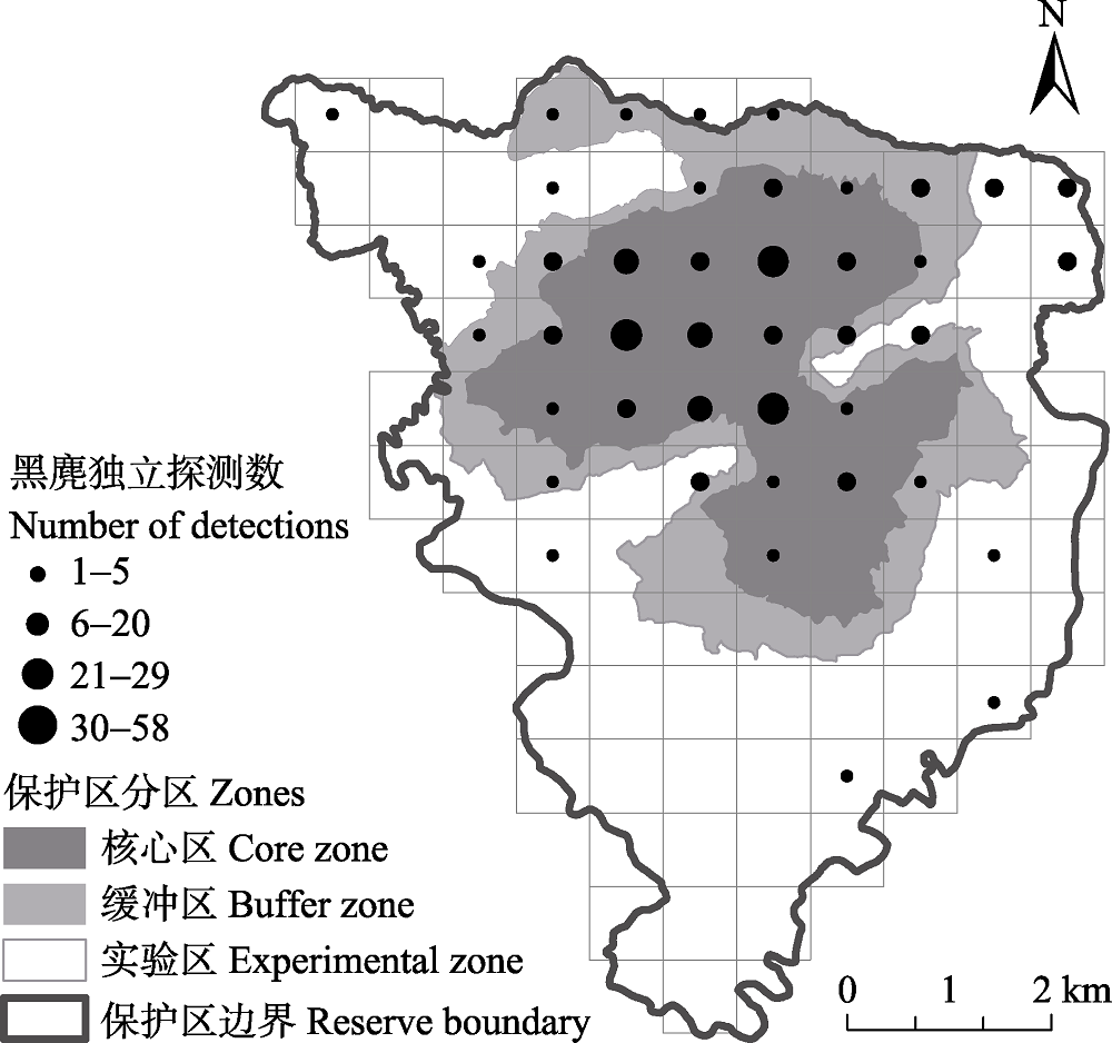
图1 古田山国家级自然保护区2014-2018年红外相机调查网格与黑麂记录位点
Fig. 1 Camera-trapping survey grids and the occurrence locations of black muntjac in the Gutianshan National Nature Reserve, 2014-2018
| 变量 Variables | 代码 Code | 变量类型 Data type | 范围/类型 Range/Content |
|---|---|---|---|
| 海拔 Elevation (m) | ELE | 连续 Continuous | 170-1,260 |
| 坡度 Slope (o) | Slope | 连续 Continuous | 0-53.2 |
| 坡向 Aspect | Aspect | 分类 Categorical | 阳坡/阴坡 Warm/cold aspect |
| 地表崎岖度 Ruggedness (m) | TRI | 连续 Continuous | 0-52.7 |
| 土地利用类型 Land use type | LU | 分类 Categorical | 乔木林、竹林、疏林、特殊灌木林地、苗圃等13类 Forest, bamboo forest, shrub, special shrub land, nursery etc. |
| 森林类型 Forest type | FOR_type | 分类 Categorical | 针叶林、阔叶林、针阔混交林、非林地 Conifer, broadleaf, conifer and broadleaf mixed forest, and non-forest |
| 森林完整性 Forest intactness | FOR_int | 分类 Categorical | 无干扰的原始林、轻度干扰的天然林、重度干扰的天然林或人工林 Primary forest, natural forest with light disturbance, natural forest with heavy disturbance/planted forests |
| 林龄 Age of stand | FOR_age | 分类 Categorical | 幼龄林、中龄林、近熟林、成熟林、过熟林、非林地 Young forest, middle-aged forest, near-mature forest, mature forest, over-ripe forest, non-forest land |
| 优势树种 Dominant species | FOR_spp | 分类 Categorical | 马尾松, 黄山松, 池杉等共60类 Pinus massoniana, Pinus taiwanensis, Taxodium ascendens, etc. |
| 主干道密度 Density of large roads (m/km2) | LRD_den | 连续 Continuous | 0-2.01 |
| 总道路密度 Density of all roads (m/km2) | TRD_den | 连续 Continuous | 0.04-4.37 |
| 与最近道路距离 Distance to nearest road (m) | TRD_dist | 连续 Continuous | 0-3,750 |
| 居民点密度 House density (m2/km2) | HOU_den | 连续 Continuous | 0-75,100 |
| 与最近居民点距离 Distance to nearest house (m) | HOU_dist | 连续 Continuous | 0-2,650 |
| 河流密度 River density (m/km2) | RIV_den | 连续 Continuous | 0.40-2.22 |
| 与最近河流距离 Distance to nearest river (m) | RIV_dist | 连续 Continuous | 0-1,150 |
表1 用于钱江源国家公园体制试点区内黑麂适宜栖息地评估的环境因子
Table 1 Environmental variables used to construct the distribution models of black muntjac in the Qianjiangyuan National Park pilot site
| 变量 Variables | 代码 Code | 变量类型 Data type | 范围/类型 Range/Content |
|---|---|---|---|
| 海拔 Elevation (m) | ELE | 连续 Continuous | 170-1,260 |
| 坡度 Slope (o) | Slope | 连续 Continuous | 0-53.2 |
| 坡向 Aspect | Aspect | 分类 Categorical | 阳坡/阴坡 Warm/cold aspect |
| 地表崎岖度 Ruggedness (m) | TRI | 连续 Continuous | 0-52.7 |
| 土地利用类型 Land use type | LU | 分类 Categorical | 乔木林、竹林、疏林、特殊灌木林地、苗圃等13类 Forest, bamboo forest, shrub, special shrub land, nursery etc. |
| 森林类型 Forest type | FOR_type | 分类 Categorical | 针叶林、阔叶林、针阔混交林、非林地 Conifer, broadleaf, conifer and broadleaf mixed forest, and non-forest |
| 森林完整性 Forest intactness | FOR_int | 分类 Categorical | 无干扰的原始林、轻度干扰的天然林、重度干扰的天然林或人工林 Primary forest, natural forest with light disturbance, natural forest with heavy disturbance/planted forests |
| 林龄 Age of stand | FOR_age | 分类 Categorical | 幼龄林、中龄林、近熟林、成熟林、过熟林、非林地 Young forest, middle-aged forest, near-mature forest, mature forest, over-ripe forest, non-forest land |
| 优势树种 Dominant species | FOR_spp | 分类 Categorical | 马尾松, 黄山松, 池杉等共60类 Pinus massoniana, Pinus taiwanensis, Taxodium ascendens, etc. |
| 主干道密度 Density of large roads (m/km2) | LRD_den | 连续 Continuous | 0-2.01 |
| 总道路密度 Density of all roads (m/km2) | TRD_den | 连续 Continuous | 0.04-4.37 |
| 与最近道路距离 Distance to nearest road (m) | TRD_dist | 连续 Continuous | 0-3,750 |
| 居民点密度 House density (m2/km2) | HOU_den | 连续 Continuous | 0-75,100 |
| 与最近居民点距离 Distance to nearest house (m) | HOU_dist | 连续 Continuous | 0-2,650 |
| 河流密度 River density (m/km2) | RIV_den | 连续 Continuous | 0.40-2.22 |
| 与最近河流距离 Distance to nearest river (m) | RIV_dist | 连续 Continuous | 0-1,150 |
| 斑块编号 Patch ID | 斑块面积 Area (ha) | 核心栖息地面积 Core area (ha) | 核心栖息地数量 Number of core area | 核心栖息地面积比例 Core area percentage (%) |
|---|---|---|---|---|
| 所有斑块 All patches | 4,254 | 1,992 | 92 | 46.8 |
| 1 | 52 | 10 | 2 | 19.4 |
| 2 | 68 | 13 | 5 | 20.0 |
| 3 | 262 | 171 | 1 | 65.2 |
| 4 | 273 | 92 | 13 | 33.9 |
| 5 | 660 | 195 | 14 | 34.9 |
| 6 | 2,395 | 1,457 | 28 | 60.8 |
表2 钱江源国家公园体制试点区内黑麂适宜栖息地及6个最大斑块的特征
Table 2 Characteristics of the suitable habitat patches, including the six largest patches, of black muntjac in the Qianjiangyuan National Park pilot site
| 斑块编号 Patch ID | 斑块面积 Area (ha) | 核心栖息地面积 Core area (ha) | 核心栖息地数量 Number of core area | 核心栖息地面积比例 Core area percentage (%) |
|---|---|---|---|---|
| 所有斑块 All patches | 4,254 | 1,992 | 92 | 46.8 |
| 1 | 52 | 10 | 2 | 19.4 |
| 2 | 68 | 13 | 5 | 20.0 |
| 3 | 262 | 171 | 1 | 65.2 |
| 4 | 273 | 92 | 13 | 33.9 |
| 5 | 660 | 195 | 14 | 34.9 |
| 6 | 2,395 | 1,457 | 28 | 60.8 |
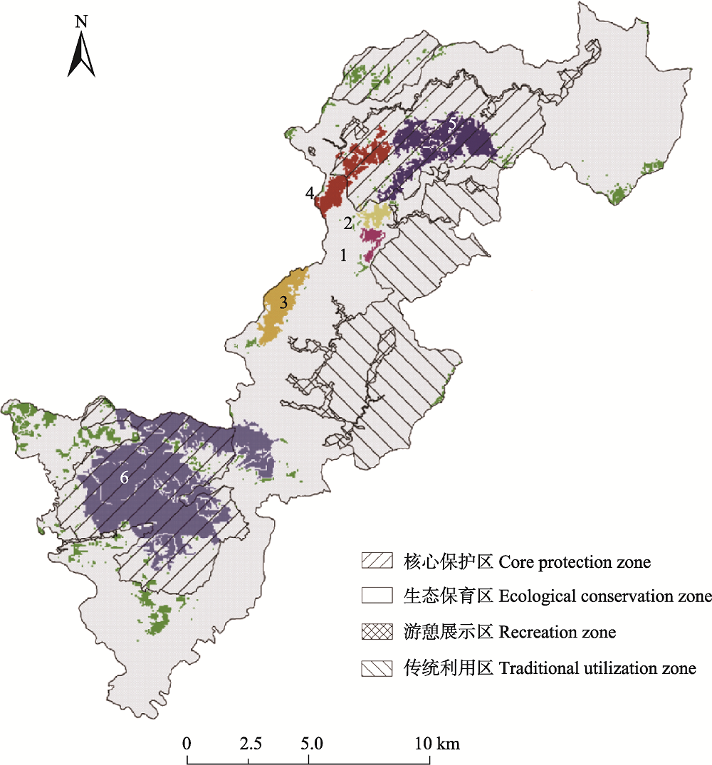
图2 钱江源国家公园体制试点区内黑麂适宜栖息地分布图。编号1-6为面积最大的6个栖息地斑块, 以不同颜色显示, 绿色斑块为其余的适宜栖息地。
Fig. 2 Distribution of black muntjac suitable habitat patches in the Qianjiangyuan National Park pilot site. Number 1-6 marks the 6 largest suitable habitat patches, represented in different colors; the left patches are shown in green.
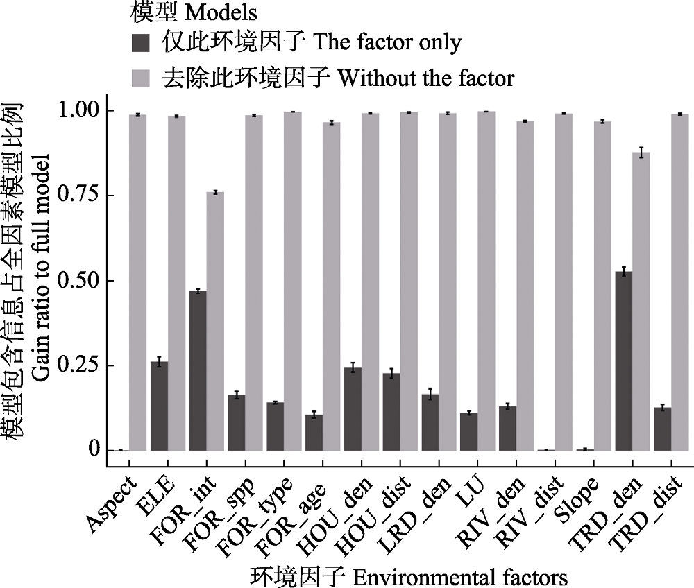
图3 Jackknife检验评估制约黑麂分布的主要环境因子及其相对贡献。代码含义见表1。
Fig. 3 Results of Jackknife evaluation on the relative importance of environmental variables to the presence of black muntjac. Please refer to Table 1 for code definition.
| [1] | Ball IR, Possingham H ( 2000) Marxan (V1.8.2): Marine Reserve Design Using Spatially Explicit Annealing. 2000) Marxan (V1.8.2): Marine Reserve Design Using Spatially Explicit Annealing. . (accessed on 2019-01-01) |
| [2] |
Bao YX, Zheng X, Ge BM ( 2006) An assessment and protective strategy of black muntjac (Muntiacus crinifrons) habitat in Zhejiang Province. Acta Ecologica Sinica, 26, 2425-2431. (in Chinese with English abstract)
DOI URL |
|
[ 鲍毅新, 郑祥, 葛宝明 ( 2006) 浙江黑麂栖息地评价及保护对策. 生态学报, 26, 2425-2431.]
DOI URL |
|
| [3] |
Chen LD, Fu BJ, Liu XH ( 2000) Landscape pattern design and wildlife conservation in nature reserve—Case study of Wolong Nature Reserve. Journal of Nature Resources, 15, 164-169. (in Chinese with English abstract)
DOI URL |
|
[ 陈利顶, 傅伯杰, 刘雪华 ( 2000) 自然保护区景观结构设计与物种保护——以卧龙自然保护区为例. 自然资源学报, 15, 164-169.]
DOI URL |
|
| [4] |
Chen SW, Yu JP, Chen XN, Shen XL, Li S, Ma KP ( 2016) Camera-trapping survey on the diversity of mammal and pheasant species in Gutianshan National Nature Reserve, Zhejiang Province. Acta Theriologica Sinica, 36, 292-301. (in Chinese with English abstract)
DOI URL |
|
[ 陈声文, 余建平, 陈小南, 申小莉, 李晟, 马克平 ( 2016) 利用红外相机网络调查古田山自然保护区的兽类及雉类多样性. 兽类学报, 36, 292-301.]
DOI URL |
|
| [5] |
Huyan JQ, Xiao J, Yu BW, Xu WH ( 2014) Research progress in function zoning of nature reserves in China. Acta Ecologica Sinica, 34, 6391-6396. (in Chinese with English abstract)
DOI URL |
|
[ 呼延佼奇, 肖静, 于博威, 徐卫华 ( 2014) 我国自然保护区功能分区研究进展. 生态学报, 34, 6391-6396.]
DOI URL |
|
| [6] |
Li S, Wang DJ, Xiao ZS, Li XH, Wang TM, Feng LM, Wang Y ( 2014) Camera-trapping in wildlife research and conservation in China: Review and outlook. Biodiversity Science, 22, 685-695. (in Chinese with English abstract)
DOI URL |
|
[ 李晟, 王大军, 肖治术, 李欣海, 王天明, 冯利民, 王云 ( 2014) 红外相机技术在我国野生动物研究与保护中的应用与前景. 生物多样性, 22, 685-695.]
DOI URL |
|
| [7] |
Li WJ, Wang ZJ, Ma ZJ, Tang HX ( 1999) Designing the core zone in a biosphere reserve based on suitable habitats: Yancheng Biosphere Reserve and the red crowned crane (Grus japonensis). Biological Conservation, 90, 167-173.
DOI URL |
| [8] |
Liu XH, Li JH ( 2008) Scientific solutions for the functional zoning of nature reserves in China. Ecological Modelling, 215, 237-246.
DOI URL |
| [9] |
Liu XJ, Trogisch S, He JS, Niklaus PA, Bruelheide H, Tang ZR, Erfmeier A, Scherer-Lorenzen M, Pietsch KA, Yang B, Kuhn P, Scholten T, Huang YY, Wang C, Staab M, Leppert KN, Wirth C, Schmid B, Ma KP ( 2018) Tree species richness increases ecosystem carbon storage in subtropical forests. Proceedings of the Royal Society B: Biological Sciences, 285, 20181240.
DOI URL |
| [10] | McGarigal K, Cushman SA, Neel MC, Ene E ( 2002) FRAGSTATS: Spatial pattern analysis program for categorical maps. . ( accessed on 2019-01-01) |
| [11] |
Phillips SJ, Dudík M ( 2008) Modeling of species distributions with MaxEnt: New extensions and a comprehensive evaluation. Ecography, 31, 161-175.
DOI URL |
| [12] | Riley SJ ( 1999) Index that quantifies topographic heterogeneity. Intermountain Journal of Sciences, 5, 23-27. |
| [13] | Sheng HL ( 1987) China’s endemic species: Black muntjac. Chinese Journal of Zoology, 52(2), 48-51. (in Chinese) |
| [ 盛和林 ( 1987) 中国特产动物——黑麂. 动物学杂志, 52(2), 48-51.] | |
| [14] | Shi JY, Ma LS, Yang KL, Fan JC, Shi RH ( 1998) Fuzzy division of functional areas in Wolong Nature Reserve. Journal of Sichuan Forestry Science and Technology, 19, 6-16. (in Chinese with English abstract) |
| [ 史军义, 马丽莎, 杨克珞, 范继才, 史蓉红 ( 1998) 卧龙自然保护区功能区的模糊划分. 四川林业科技, 19, 6-16.] | |
| [15] | Tang FL, Wang MJ, Li GQ ( 2017) Discussion on zoning for national park function. Forest Construction, ( 6), 1-7. (in Chinese with English abstract) |
| [ 唐芳林, 王梦君, 黎国强 ( 2017) 国家公园功能分区探讨. 林业建设, ( 6), 1-7.] | |
| [16] |
Tao J, Zang RG, Hua CL, Wen QZ ( 2012) Discussion on the functional zoning of forest ecosystem nature reserve. Forest Resources Management, ( 6), 47- 50, 56. (in Chinese with English abstract)
DOI |
|
[ 陶晶, 臧润国, 华朝朗, 温庆忠 ( 2012) 森林生态系统类型自然保护区功能区划探讨. 林业资源管理, ( 6), 47- 50, 56..]
DOI |
|
| [17] |
Wang Y ( 2017) Practice and innovation for overarching institution design of China’s national park. Biodiversity Science, 25, 1037-1039. (in Chinese)
DOI URL |
|
[ 王毅 ( 2017) 中国国家公园顶层制度设计的实践与创新. 生物多样性, 25, 1037-1039.]
DOI URL |
|
| [18] |
Watts ME, Ball IR, Stewart RS, Klein CJ, Wilson K, Steinback C, Lourival R, Kircher L, Possingham HP ( 2009) Marxan with Zones: Software for optimal conservation based land- and sea-use zoning. Environmental Modelling and Software, 24, 1513-1521.
DOI URL |
| [19] | Xu WH, Luo C, Ouyang ZY, Zhang L ( 2010) Designing regional nature reserves group: The case study of Qinling Mountain Range, China. Acta Ecologica Sinica, 30, 1648-1654. (in Chinese with English abstract) |
| [ 徐卫华, 罗翀, 欧阳志云, 张路 ( 2010) 区域自然保护区群规划——以秦岭山系为例. 生态学报, 30, 1648-1654.] | |
| [20] |
Xu WH, Vina A, Qi ZX, Ouyang ZY, Liu JG, Liu W, Wan H ( 2014) Evaluating conservation effectiveness of nature reserves established for surrogate species: Case of a giant panda nature reserve in Qinling Mountains, China. Chinese Geographical Science, 24, 60-70.
DOI URL |
| [21] |
Yang R ( 2017) Conservation first, national representative, and commonwealth: The three concepts of China’s National Park System Construction. Biodiversity Science, 25, 1040-1041. (in Chinese)
DOI URL |
|
[ 杨锐 ( 2017) 生态保护第一、国家代表性、全民公益性——中国国家公园体制建设的三大理念. 生物多样性, 25, 1040-1041.]
DOI URL |
|
| [22] |
Yu H, Chen T, Zhong LS, Zhou R ( 2017) Functional zoning of the Qianjiangyuan National Park System Pilot Area. Resources Science, 39, 20-29. (in Chinese with English abstract)
DOI URL |
|
[ 虞虎, 陈田, 钟林生, 周睿 ( 2017) 钱江源国家公园体制试点区功能分区研究. 资源科学, 39, 20-29.]
DOI URL |
|
| [23] |
Zheng X, Bao YX, Ge BM, Zheng RQ ( 2006) Seasonal changes in habitat use of black muntjac (Muntiacus crinifrons) in Zhejiang. Acta Theriologica Sinica, 26, 201-205. (in Chinese with English abstract)
DOI URL |
|
[ 郑祥, 鲍毅新, 葛宝明, 郑荣泉 ( 2006) 黑麂栖息地利用的季节变化. 兽类学报, 26, 201-205.]
DOI URL |
| [1] | 李劲, 程铭昊, 张溢, 刘峰, 姜庆虎, 叶基荣, 陈展, 张于光. 不同海拔巴山冷杉林土壤微生物多样性及植物-微生物跨界生态网络关系[J]. 生物多样性, 2026, 34(4): 25276-. |
| [2] | 谷际岐, 赖江山, 王瑛, 吴浩然, 张雪, 宋晓彤, 邵小明, 娄安如. 联合物种分布模型与生物群落层次建模框架: 生态学理论、方法及应用[J]. 生物多样性, 2026, 34(1): 25364-. |
| [3] | 孙啸宇. 中国国家公园人兽冲突解决的法治路径[J]. 生物多样性, 2026, 34(1): 25040-. |
| [4] | 李基才, 邵长亮, 高帅帅, 李佳. 新疆卡拉麦里国家公园候选区蒙古野驴夏季水源利用规律、活动范围和适宜生境分布[J]. 生物多样性, 2025, 33(7): 24509-. |
| [5] | 刘咏华, 童光蓉, 余航远, 王宁宁, 任海保, 陈磊, 马克平, 米湘成. 钱江源-百山祖国家公园候选区钱江源园区冠层三维结构及光谱特征对人为干扰的响应[J]. 生物多样性, 2025, 33(4): 24174-. |
| [6] | 田志奇, 苏杨. 环境相关国际公约的中国履约模式和在《生物多样性公约》中的应用: 从完成《昆蒙框架》目标和发挥国家公园作用的角度[J]. 生物多样性, 2025, 33(3): 24593-. |
| [7] | 苏红巧, 余得光, 牟昆仑. 国家公园与国土空间规划和用途管制制度衔接路径探讨[J]. 生物多样性, 2025, 33(3): 24570-. |
| [8] | 廖之锴, 白皓天, 张修瀚, 余上, 凌嘉乐, 刘阳. 海南热带雨林国家公园常见鸟类鸣声数据集[J]. 生物多样性, 2025, 33(11): 25194-. |
| [9] | 张雨琦, 文君, 张引, 李晟之. 大熊猫国家公园全民公益性评价研究: 基于利益相关者感知视角[J]. 生物多样性, 2024, 32(9): 24240-. |
| [10] | 韩思成, 陆道炜, 韩宇辰, 栗若寒, 杨晶, 孙戈, 杨陆, 钱俊伟, 方翔, 罗述金. 北京近郊浅山地区的野生豹猫分布及环境影响因素[J]. 生物多样性, 2024, 32(8): 24138-. |
| [11] | 鄢德奎. 中国生物多样性保护政策的共同要素、不足和优化建议[J]. 生物多样性, 2024, 32(5): 23293-. |
| [12] | 王巍伟, 米湘成, 王宁宁, 任海保, 唐治喜, 张主宁, 马克平, 陈磊. 2005-2020年浙江古田山24 ha亚热带常绿阔叶林动态监测样地植物多样性数据集[J]. 生物多样性, 2024, 32(12): 24417-. |
| [13] | 耿云, 寇一祎, 范新卓, 徐姝瑶, 丛丽, 张玉钧. 基于卡诺模型的大熊猫国家公园自然教育需求研究[J]. 生物多样性, 2024, 32(1): 23101-. |
| [14] | 杜宇晨, 刘蓓萌, 陈俊峰, 王浩, 谢屹. 基于结构方程模型的农户保护意愿影响因素分析: 以东北虎豹国家公园珲春片区为例[J]. 生物多样性, 2024, 32(1): 23155-. |
| [15] | 崔国发. 关于自然保护地整合优化工作中几个关键问题的讨论与建议[J]. 生物多样性, 2023, 31(9): 22447-. |
| 阅读次数 | ||||||
|
全文 |
|
|||||
|
摘要 |
|
|||||
备案号:京ICP备16067583号-7
Copyright © 2026 版权所有 《生物多样性》编辑部
地址: 北京香山南辛村20号, 邮编:100093
电话: 010-62836137, 62836665 E-mail: biodiversity@ibcas.ac.cn
![]()