
生物多样性 ›› 2018, Vol. 26 ›› Issue (8): 789-806. DOI: 10.17520/biods.2018054 cstr: 32101.14.biods.2018054
郭庆华1,2,*( ), 胡天宇1,2, 姜媛茜3, 金时超1,2, 王瑞1,2, 关宏灿1,2, 杨秋丽4, 李玉美1,2, 吴芳芳1,2, 翟秋萍1,2, 刘瑾1,2, 苏艳军1,2
收稿日期:2018-07-22
接受日期:2018-07-24
出版日期:2018-08-20
发布日期:2018-09-27
通讯作者:
郭庆华
作者简介:# 共同第一作者
基金资助:
Qinghua Guo1,2,*(), Tianyu Hu1,2, Yuanxi Jiang3, Shichao Jin1,2, Rui Wang1, Hongcan Guan1,2, Qiuli Yang4, Yumei Li1,2, Fangfang Wu1,2, Qiuping Zhai1,2, Jin Liu1,2, Yanjun Su1,2
Received:2018-07-22
Accepted:2018-07-24
Online:2018-08-20
Published:2018-09-27
Contact:
Guo Qinghua
About author:# Co-first authors
摘要:
随着人口的持续增长, 人类经济活动对自然资源的利用强度不断升级以及全球气候变暖, 全球物种正以前所未有的速度丧失, 生物多样性成为了全球关注的热点问题。传统生物多样性研究以地面调查方法为主, 重点关注物种或样地水平, 但无法满足景观尺度、区域尺度以及全球尺度的生物多样性保护和评估需求。遥感作为获取生物多样性信息的另一种手段, 近年来在生物多样性领域发展迅速, 其覆盖广、序列性以及可重复性等特点使之在大尺度生物多样性监测和制图以及评估方面具有极大优势。本文主要通过文献收集整理, 从观测手段、研究尺度、观测对象和生物多样性关注点等方面综述了遥感在生物多样性研究中的应用现状, 重点分析不同遥感平台的技术优势和局限性, 并探讨了未来遥感在生物多样性研究的应用趋势。遥感平台按观测高度可分为近地面遥感、航空遥感和卫星遥感, 能够获取样地-景观-区域-洲际-全球尺度的生物多样性信息。星载平台在生物多样性研究中应用最多, 航空遥感的应用研究偏少主要受飞行成本限制。近地面遥感作为一个新兴平台, 能够直接观测到物种的个体, 获取生物多样性关注的物种和种群信息, 是未来遥感在生物多样性应用中的发展方向。虽然遥感技术在生物多样性研究中的应用存在一定的局限性, 未来随着传感器发展和多源数据融合技术的完善, 遥感能更好地从多个尺度、全方位地服务于生物多样性保护和评估。
郭庆华, 胡天宇, 姜媛茜, 金时超, 王瑞, 关宏灿, 杨秋丽, 李玉美, 吴芳芳, 翟秋萍, 刘瑾, 苏艳军 (2018) 遥感在生物多样性研究中的应用进展. 生物多样性, 26, 789-806. DOI: 10.17520/biods.2018054.
Qinghua Guo, Tianyu Hu, Yuanxi Jiang, Shichao Jin, Rui Wang, Hongcan Guan, Qiuli Yang, Yumei Li, Fangfang Wu, Qiuping Zhai, Jin Liu, Yanjun Su (2018) Advances in remote sensing application for biodiversity research. Biodiversity Science, 26, 789-806. DOI: 10.17520/biods.2018054.
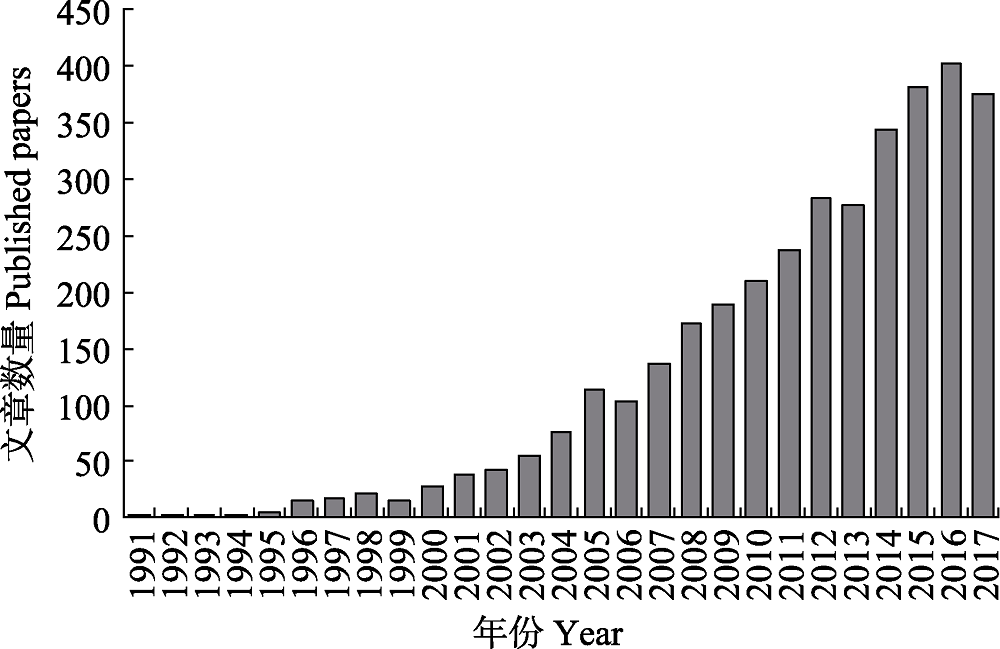
图1 遥感在生物多样性研究中的文献数量变化趋势
Fig. 1 The trend of literature quantity of remote sensing in biodiversity
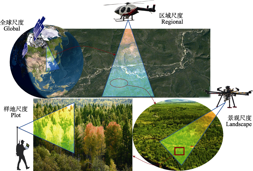
图2 不同遥感平台在生物多样性研究中的观测尺度
Fig. 2 Observation scale of different remote sensing platforms in biodiversity research
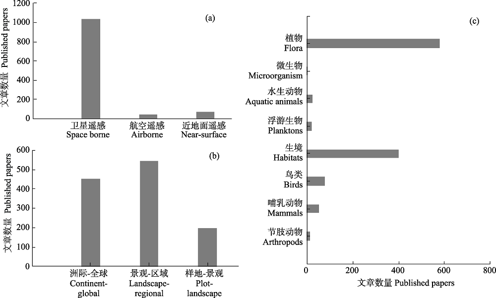
图3 生物多样性研究在遥感平台(a)、关注尺度(b)和研究对象(c)中的文献数量
Fig. 3 Literature quantity of remote sensing platform (a), study scale (b) and biodiversity group (c) in biodiversity research
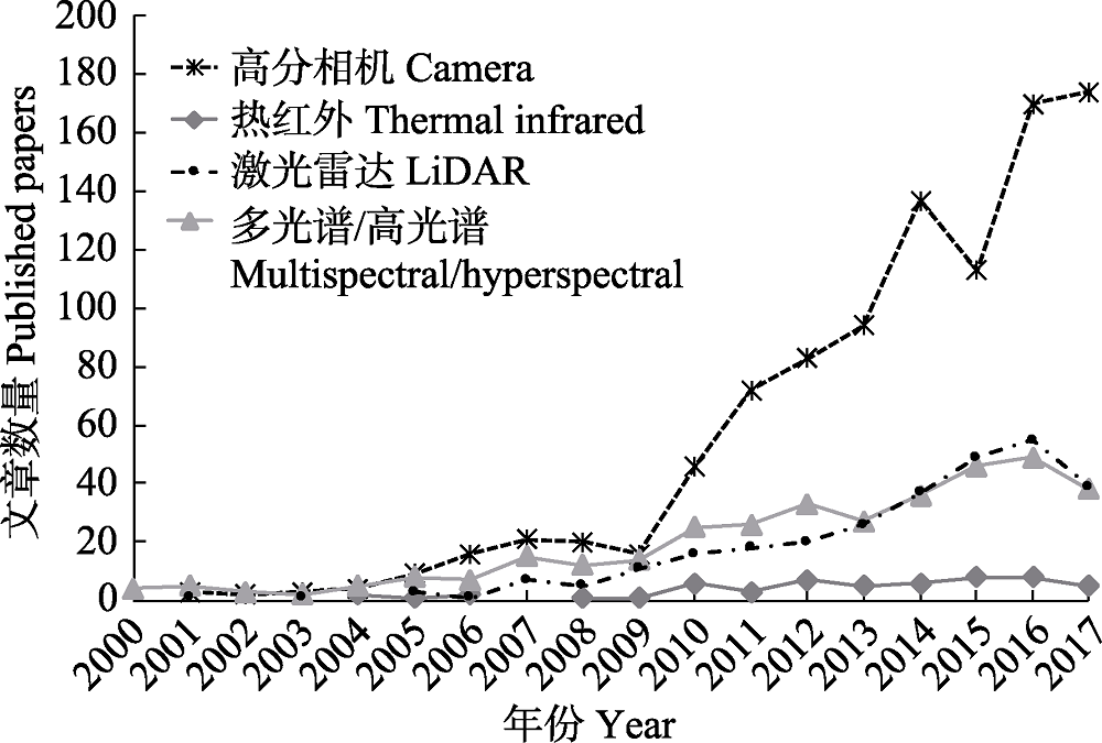
图4 不同传感器在生物多样性研究中的文献数量变化趋势
Fig. 4 The trend of literatures about different remote sensing senors using in biodiversity research
| 卫星 Satellite | 传感器 Sensor | 传感器类型 Type of sensor | 波段数 Bands | 空间分辨率 Spatial resolution | 重返时间 Repeat interval | 发射时间 Launch date | |
|---|---|---|---|---|---|---|---|
| LandSat 5 | TM | 多光谱 Multispectral | 7 | Band 1-5, 7: 30 m Band 6: 120 m | 16 d | 1984 (2013宣布失效) (Deactivated in 2013) | |
| LandSat 7 | ETM+ | 全色/多光谱 Panchromatic/ multispectral | 8 | Band 8: 15 m Band 1-5, 7: 30 m Band 6: 60 m | 16 d | 1999 (2003.05设备故障,影像出现条带状) (SLC-off in 2003.05) | |
| LandSat 8 | OLI | 全色/多光谱 Panchromatic/ multispectral | 9 | Band 8: 15 m Band 1-7, 9: 30 m | 16 d | 2013 | |
| TRS | 热红外 Thermal infrared | 2 | 100 m | ||||
| QucikBird-2 | CCD相机 CCD camera | 全色/多光谱 Panchromatic/ multispectral | 4 | 全色: 0.61 m Panchromatic 多光谱: 2.44 m Multispectral | 1-6 d | 2001 (2015宣布失效) (Deactivated in 2015) | |
| IKONOS | CCD相机 CCD camera | 全色/多光谱 Panchromatic/ multispectral | 4 | 全色: 1 m Panchromatic 多光谱: 4 m Multispectral | 3 d | 1999 (2015年宣布退役) (Deactivated in 2015) | |
| SPOT 5 | HRG | 全色/多光谱 Panchromatic/ multispectral | 4 | 全色: 2.5 m Panchromatic Band 1-3: 10 m Band 4: 20 m | 26 d | 2002 | |
| SPOT 7 | NAOMI | 全色/多光谱 Panchromatic/ multispectral | 4 | 全色: 1.5 m Panchromatic 多光谱: 6 m Multispectral | 26 d | 2014 | |
| GeoEye-1 | CCD相机 | 全色/多光谱 Panchromatic/ multispectral | 4 | 全色: 0.41 m Panchromatic 多光谱: 1.65 m Multispectral | 2-3 d | 2008 | |
| WorldView-3 | CCD相机 | 全色/多光谱/短波红外/CAVIS Panchromatic/ multispectral/ Short wavelength infrared/CAVIS | 29 | 全色: 0.31 m Panchromatic 多光谱: 1.24 m Multispectral 短波红外: 3.7 m Short wavelength infrared CAVIS 30 m | 小于1 d | 2014 | |
| 卫星 Satellite | 传感器 Sensor | 传感器类型 Type of sensor | 波段数 Bands | 空间分辨率 Spatial resolution | 重返时间 Repeat interval | 发射时间 Launch date | |
| WorldView-4 | CCD相机 | 全色/多光谱 Panchromatic/ multispectral | 4 | 全色: 0.31 m Panchromatic 多光谱: 1.24 m Multispectral | 1或4.5 d | 2016 | |
| Terra | ASTER | 近红外/短波红外/ 热红外 Near Infrared/Short Wavelength Infrared/ Thermal Infrared | 15 | 近红外: 15 m Near Infrared 短波红外: 30 m Short wavelength infrared 热红外: 90 m Thermal infrared | 16 d | 1999 | |
| MODIS | 多光谱 Multispectral | 36 | Band 1, 2: 250 m Band 3-7: 500 m Band 8-36: 1,000 m | ||||
| AQUA | MODIS | 多光谱 Multispectral | 36 | Band 1, 2: 250 m Band 3-7: 500 m Band 8-36: 1,000 m | 16 d | 2002 | |
| Sentinel-1A | C波段合成孔径雷达 SAR (synthetic aperture radar) with C band | SAR | - | 条带模式:5*5 m Strip map mode 干涉宽幅模式: 5*20 m Interferometric wide swath mode 超宽幅模式: 20*40 m Extra wide swath mode | 6 d | 2014 | |
| Sentinel-2A | 多光谱成像仪 Multispectral scanner | 多光谱 Multispectral | 13 | Band 2-4, 8: 10 m Band 5-7, 8A, 11, 12: 20 m Band 1, 9, 10: 60 m | 10 d | 2015 | |
| GF-1 | 全色多光谱相机 Panchromatic multispectral scanner | 全色/多光谱 Panchromatic/ multispectral | 5 | Band 1: 2 m Band 2-5: 8 m | 4 d | 2013 | |
| 多光谱相机 Multispectral scanner | 多光谱 Multispectral | 4 | 16 m | ||||
| GF-2 | 全色多光谱相机 Panchromatic multispectral scanner | 全色/多光谱 Panchromatic/ multispectral | 5 | Band 1: 1 m Band 2-5: 4 m | 5 d | 2014 | |
| GF-3 | C波段合成孔径雷达 SAR with C band | SAR | - | 因成像模式而定 (1, 3, 5, 8, 10, 25, 50, 100, 500 m) Resolution depend on the scan mode | - | 2016 | |
| GF-4 | 面阵凝视相机 Staring array camera | 可见光/近红外/ 中波红外 Visible/Near infrared/ Middle infrared | 6 | 可见光近红外: 50 m Visible/near infrared 中波红外: 400 m Middle infrared | 20 s | 2015 | |
| ZY-1 02C | 全色多光谱相机 Panchromatic multispectral scanner | 全色/多光谱 Panchromatic/ multispectral | 4 | 全色: 5m Panchromatic 多光谱: 10 m Multispectral | 3 d | 2011 | |
| 全色高分辨率相机 Panchromatic high-resolution scanner | 全色 Panchromatic | - | 2.36 m | ||||
| ZY-3 | 正视全色TDI CCD相机 Ortho-panchromatic TDI CCD camera | 全色 Panchromatic | - | 2.1 m | 5 d | 2012 | |
| 前视、后视TDI CCD相机 fore sigh and back sight TDI CCD camera | 全色 Panchromatic | - | 3.5 m | ||||
| 正视多光谱相机 Multispectral ortho-imager | 多光谱 Multispectral | 4 | 6 m | ||||
| 卫星 Satellite | 传感器 Sensor | 传感器类型 Type of sensor | 波段数 Bands | 空间分辨率 Spatial resolution | 重返时间 Repeat interval | 发射时间 Launch date | |
| HJ-1A | CCD相机 CCD camera | 多光谱 Multispectral | 4 | 30 m | 4 d | 2008 | |
| 高光谱成像仪 Hyperspectral scanner | 高光谱 Hyperspectral | 110-128 | 100 m | ||||
| HJ-1B | CCD相机 CCD camera | 多光谱 Multispectral | 4 | 30 m | 4 d | 2008 | |
| 红外多光谱相机 Infrared multispectral scanner | 红外 Infrared | 4 | 150 m | ||||
| HJ-1C | 合成孔径雷达 SAR | SAR | - | 单视模式: 5 m Single mode 距离向四视模式: 20 m Four sights at range direction | 4 d | 2012 | |
表1 国内外常用遥感卫星及其基本参数简介
Table 1 the parameters list of Chinese and international popular remote sensing satellites
| 卫星 Satellite | 传感器 Sensor | 传感器类型 Type of sensor | 波段数 Bands | 空间分辨率 Spatial resolution | 重返时间 Repeat interval | 发射时间 Launch date | |
|---|---|---|---|---|---|---|---|
| LandSat 5 | TM | 多光谱 Multispectral | 7 | Band 1-5, 7: 30 m Band 6: 120 m | 16 d | 1984 (2013宣布失效) (Deactivated in 2013) | |
| LandSat 7 | ETM+ | 全色/多光谱 Panchromatic/ multispectral | 8 | Band 8: 15 m Band 1-5, 7: 30 m Band 6: 60 m | 16 d | 1999 (2003.05设备故障,影像出现条带状) (SLC-off in 2003.05) | |
| LandSat 8 | OLI | 全色/多光谱 Panchromatic/ multispectral | 9 | Band 8: 15 m Band 1-7, 9: 30 m | 16 d | 2013 | |
| TRS | 热红外 Thermal infrared | 2 | 100 m | ||||
| QucikBird-2 | CCD相机 CCD camera | 全色/多光谱 Panchromatic/ multispectral | 4 | 全色: 0.61 m Panchromatic 多光谱: 2.44 m Multispectral | 1-6 d | 2001 (2015宣布失效) (Deactivated in 2015) | |
| IKONOS | CCD相机 CCD camera | 全色/多光谱 Panchromatic/ multispectral | 4 | 全色: 1 m Panchromatic 多光谱: 4 m Multispectral | 3 d | 1999 (2015年宣布退役) (Deactivated in 2015) | |
| SPOT 5 | HRG | 全色/多光谱 Panchromatic/ multispectral | 4 | 全色: 2.5 m Panchromatic Band 1-3: 10 m Band 4: 20 m | 26 d | 2002 | |
| SPOT 7 | NAOMI | 全色/多光谱 Panchromatic/ multispectral | 4 | 全色: 1.5 m Panchromatic 多光谱: 6 m Multispectral | 26 d | 2014 | |
| GeoEye-1 | CCD相机 | 全色/多光谱 Panchromatic/ multispectral | 4 | 全色: 0.41 m Panchromatic 多光谱: 1.65 m Multispectral | 2-3 d | 2008 | |
| WorldView-3 | CCD相机 | 全色/多光谱/短波红外/CAVIS Panchromatic/ multispectral/ Short wavelength infrared/CAVIS | 29 | 全色: 0.31 m Panchromatic 多光谱: 1.24 m Multispectral 短波红外: 3.7 m Short wavelength infrared CAVIS 30 m | 小于1 d | 2014 | |
| 卫星 Satellite | 传感器 Sensor | 传感器类型 Type of sensor | 波段数 Bands | 空间分辨率 Spatial resolution | 重返时间 Repeat interval | 发射时间 Launch date | |
| WorldView-4 | CCD相机 | 全色/多光谱 Panchromatic/ multispectral | 4 | 全色: 0.31 m Panchromatic 多光谱: 1.24 m Multispectral | 1或4.5 d | 2016 | |
| Terra | ASTER | 近红外/短波红外/ 热红外 Near Infrared/Short Wavelength Infrared/ Thermal Infrared | 15 | 近红外: 15 m Near Infrared 短波红外: 30 m Short wavelength infrared 热红外: 90 m Thermal infrared | 16 d | 1999 | |
| MODIS | 多光谱 Multispectral | 36 | Band 1, 2: 250 m Band 3-7: 500 m Band 8-36: 1,000 m | ||||
| AQUA | MODIS | 多光谱 Multispectral | 36 | Band 1, 2: 250 m Band 3-7: 500 m Band 8-36: 1,000 m | 16 d | 2002 | |
| Sentinel-1A | C波段合成孔径雷达 SAR (synthetic aperture radar) with C band | SAR | - | 条带模式:5*5 m Strip map mode 干涉宽幅模式: 5*20 m Interferometric wide swath mode 超宽幅模式: 20*40 m Extra wide swath mode | 6 d | 2014 | |
| Sentinel-2A | 多光谱成像仪 Multispectral scanner | 多光谱 Multispectral | 13 | Band 2-4, 8: 10 m Band 5-7, 8A, 11, 12: 20 m Band 1, 9, 10: 60 m | 10 d | 2015 | |
| GF-1 | 全色多光谱相机 Panchromatic multispectral scanner | 全色/多光谱 Panchromatic/ multispectral | 5 | Band 1: 2 m Band 2-5: 8 m | 4 d | 2013 | |
| 多光谱相机 Multispectral scanner | 多光谱 Multispectral | 4 | 16 m | ||||
| GF-2 | 全色多光谱相机 Panchromatic multispectral scanner | 全色/多光谱 Panchromatic/ multispectral | 5 | Band 1: 1 m Band 2-5: 4 m | 5 d | 2014 | |
| GF-3 | C波段合成孔径雷达 SAR with C band | SAR | - | 因成像模式而定 (1, 3, 5, 8, 10, 25, 50, 100, 500 m) Resolution depend on the scan mode | - | 2016 | |
| GF-4 | 面阵凝视相机 Staring array camera | 可见光/近红外/ 中波红外 Visible/Near infrared/ Middle infrared | 6 | 可见光近红外: 50 m Visible/near infrared 中波红外: 400 m Middle infrared | 20 s | 2015 | |
| ZY-1 02C | 全色多光谱相机 Panchromatic multispectral scanner | 全色/多光谱 Panchromatic/ multispectral | 4 | 全色: 5m Panchromatic 多光谱: 10 m Multispectral | 3 d | 2011 | |
| 全色高分辨率相机 Panchromatic high-resolution scanner | 全色 Panchromatic | - | 2.36 m | ||||
| ZY-3 | 正视全色TDI CCD相机 Ortho-panchromatic TDI CCD camera | 全色 Panchromatic | - | 2.1 m | 5 d | 2012 | |
| 前视、后视TDI CCD相机 fore sigh and back sight TDI CCD camera | 全色 Panchromatic | - | 3.5 m | ||||
| 正视多光谱相机 Multispectral ortho-imager | 多光谱 Multispectral | 4 | 6 m | ||||
| 卫星 Satellite | 传感器 Sensor | 传感器类型 Type of sensor | 波段数 Bands | 空间分辨率 Spatial resolution | 重返时间 Repeat interval | 发射时间 Launch date | |
| HJ-1A | CCD相机 CCD camera | 多光谱 Multispectral | 4 | 30 m | 4 d | 2008 | |
| 高光谱成像仪 Hyperspectral scanner | 高光谱 Hyperspectral | 110-128 | 100 m | ||||
| HJ-1B | CCD相机 CCD camera | 多光谱 Multispectral | 4 | 30 m | 4 d | 2008 | |
| 红外多光谱相机 Infrared multispectral scanner | 红外 Infrared | 4 | 150 m | ||||
| HJ-1C | 合成孔径雷达 SAR | SAR | - | 单视模式: 5 m Single mode 距离向四视模式: 20 m Four sights at range direction | 4 d | 2012 | |
| 生物多样性核心指标 Essential biodiversity variables | 卫星遥感能获取的指标 Indicators obtained from satellite remote sensing |
|---|---|
| 物种数量 Species populations | 物种分布 Species distribution ( |
| 物种性状 Species traits | 叶面积指数 LAI ( |
| 群落组成 Community composition | 物种密度 Species density ( |
| 生态系统功能 Ecosystem function | 植被绿度 Greenness ( |
| 生态系统结构 Ecosystem structure | 景观破碎化和异质性 Landscape fragmentation and heterogeneity ( |
表2 卫星遥感能够获取的与生物多样性核心指标相关的指标
Table 2 Biodiversity indicators that can be derived from satellite remote sensing
| 生物多样性核心指标 Essential biodiversity variables | 卫星遥感能获取的指标 Indicators obtained from satellite remote sensing |
|---|---|
| 物种数量 Species populations | 物种分布 Species distribution ( |
| 物种性状 Species traits | 叶面积指数 LAI ( |
| 群落组成 Community composition | 物种密度 Species density ( |
| 生态系统功能 Ecosystem function | 植被绿度 Greenness ( |
| 生态系统结构 Ecosystem structure | 景观破碎化和异质性 Landscape fragmentation and heterogeneity ( |
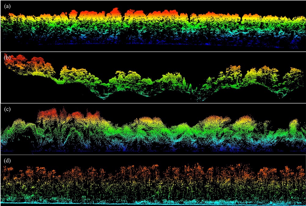
图5 无人机激光雷达获取的不同森林点云剖面图。(a)吉林长白山针阔混交林; (b)浙江古田山常绿阔叶林; (c)云南西双版纳热带雨林; (d)广东雷州红树林。
Fig. 5 Cloud profile of different forest point clouds obtained by unmanned aerial vehicle lidar. (a) Conifer and broad-leaved mixed forest in Changbai Mountain, Jilin; (b) Evergreen broad-leaved forest in Gutian Mountain, Zhejiang; (c) Tropical rain forest in Xishuangbanna, Yunnan; (d) Mangrove forest in Leizhou, Guangdong.
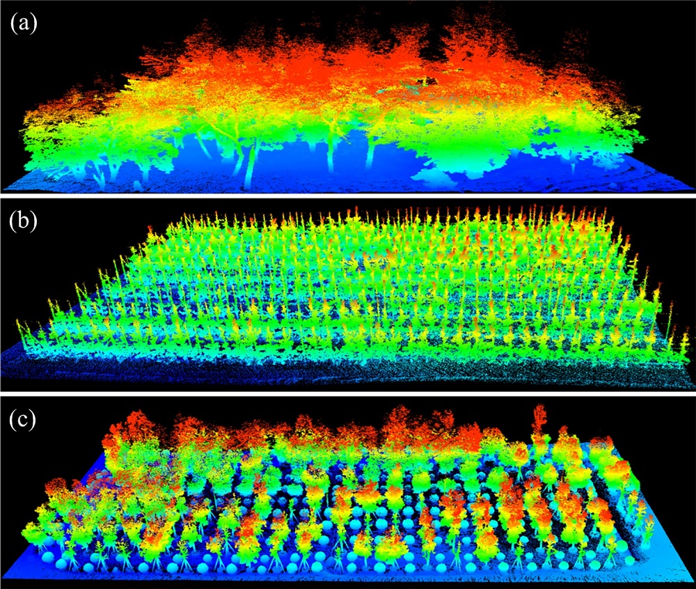
图6 背包激光雷达获取的不同样地的点云数据图。(a)植物园; (b)果园; (c)苗圃。
Fig. 6 Plot-level points cloud data obtained by backpack lidar. (a) Botanical Gardens; (b) Orchards; (c) Nurseries.
| 空间幅度与观测平台 Scale & Observation platform | 指标 Indicators | 参数 Parameters | |||
|---|---|---|---|---|---|
| 全球/洲际/国家 Global/continental/national 卫星平台 Satellite borne | 生境类型 Habitat type | 土地覆盖类型/植被类型/二者结合 Landcover/vegetation type/both | |||
| 立地条件 Stand condition | 陆面温度 Land surface temperature 大气降水 Precipitation 高程、坡度、坡向、坡位 Elevation, slope, aspect, slope position | ||||
| 生境结构 Habitat structure | 植被覆盖度 Canopy cover 植被冠层高度 Canopy height | ||||
| 生境质量 Habitat quality | 植被指数 NDVI/EVI/SAVI 叶面积指数 LAI 地上生物量 Aboveground biomass 绿度 Greenness 光合有效辐射吸收比率 FPAR | ||||
| 区域/省际 Regional/province-scale 机载平台 Airborne | 生境类型 Habitat type | 土地覆盖类型/植被类型/二者结合 Landcover/vegetation type/both | |||
| 立地条件 Stand condition | 陆面温度 Land surface temperature 大气降水 Precipitation 高程、坡度、坡向、坡位 Elevation, slope, aspect, slope position | ||||
| 生境结构 Habitat structure | 植被覆盖度 Canopy cover 植被冠层高度 Canopy height | ||||
| 生境质量 Habitat quality | 植被指数 NDVI/EVI/SAVI 叶面积指数 LAI 地上生物量 Aboveground biomass 绿度 Greenness 光合有效辐射吸收比率 FPAR | ||||
| 景观 Landscape 无人机平台 UAV borne | 生境类型 Habitat type | 植被类型 Vegetation type 景观多样性指数 Landscape diversity index | |||
| 立地条件 Stand condition | 陆面温度 Land surface temperature 大气降水 Precipitation 高程、坡度、坡向、坡位 Elevation, slope, aspect, slope position 土壤含水量 Soil water content | ||||
| 生境结构 Habitat structure | 植被覆盖度 Canopy cover 植被冠层高度 Canopy height 植被密度 Vegetation density 斑块大小、形状、丰富度 Size, shape and richness of patches | ||||
| 生境质量 Habitat quality | 植被指数 NDVI/EVI/SAVI 叶面积指数 LAI 地上生物量 Aboveground biomass 绿度 Greenness 光合有效辐射吸收比率 FPAR 景观聚集度指数 Landscape aggregation metrics 景观连通性指数 Landscape connectivity metrics 景观破碎化程度 Landscape fragmentation index | ||||
| 局地/样地 Local/plot 地基移动/固定平台 Terrestrial or mobile platform | 生境类型 Habitat type | 植被类型 Vegetation type 物种多样性指数 Biodiversity index | |||
| 立地条件 Stand condition | 土壤含水量 Soil water content 高程、坡度、坡向、坡位 Elevation, slope, aspect, slope position | ||||
| 生境结构 Habitat structure | 植被覆盖度 Canopy cover 冠层高度 Canopy height 植被密度 Vegetation density 单木树高 Individual tree height 枝下高 Crown base height 植被冠层高度剖面 Vegetation height profile 冠幅 Crown size | ||||
| 空间幅度与观测平台 Scale & Observation platform | 指标 Indicators | 参数 Parameters | |||
| 生境质量 Habitat quality | 植被指数 NDVI/EVI/SAVI 叶面积指数 LAI 地上生物量 Aboveground biomass 绿度 Greenness 光合有效辐射吸收比率FPAR 景观聚集度指数 Landscape aggregation metrics 景观连通性指数 Landscape connectivity metrics |
表3 不同空间尺度对应的生物多样性遥感监测关键指标*
Table 3 Biodiversity monitoring indicators based on remote sensing at different spatial scales
| 空间幅度与观测平台 Scale & Observation platform | 指标 Indicators | 参数 Parameters | |||
|---|---|---|---|---|---|
| 全球/洲际/国家 Global/continental/national 卫星平台 Satellite borne | 生境类型 Habitat type | 土地覆盖类型/植被类型/二者结合 Landcover/vegetation type/both | |||
| 立地条件 Stand condition | 陆面温度 Land surface temperature 大气降水 Precipitation 高程、坡度、坡向、坡位 Elevation, slope, aspect, slope position | ||||
| 生境结构 Habitat structure | 植被覆盖度 Canopy cover 植被冠层高度 Canopy height | ||||
| 生境质量 Habitat quality | 植被指数 NDVI/EVI/SAVI 叶面积指数 LAI 地上生物量 Aboveground biomass 绿度 Greenness 光合有效辐射吸收比率 FPAR | ||||
| 区域/省际 Regional/province-scale 机载平台 Airborne | 生境类型 Habitat type | 土地覆盖类型/植被类型/二者结合 Landcover/vegetation type/both | |||
| 立地条件 Stand condition | 陆面温度 Land surface temperature 大气降水 Precipitation 高程、坡度、坡向、坡位 Elevation, slope, aspect, slope position | ||||
| 生境结构 Habitat structure | 植被覆盖度 Canopy cover 植被冠层高度 Canopy height | ||||
| 生境质量 Habitat quality | 植被指数 NDVI/EVI/SAVI 叶面积指数 LAI 地上生物量 Aboveground biomass 绿度 Greenness 光合有效辐射吸收比率 FPAR | ||||
| 景观 Landscape 无人机平台 UAV borne | 生境类型 Habitat type | 植被类型 Vegetation type 景观多样性指数 Landscape diversity index | |||
| 立地条件 Stand condition | 陆面温度 Land surface temperature 大气降水 Precipitation 高程、坡度、坡向、坡位 Elevation, slope, aspect, slope position 土壤含水量 Soil water content | ||||
| 生境结构 Habitat structure | 植被覆盖度 Canopy cover 植被冠层高度 Canopy height 植被密度 Vegetation density 斑块大小、形状、丰富度 Size, shape and richness of patches | ||||
| 生境质量 Habitat quality | 植被指数 NDVI/EVI/SAVI 叶面积指数 LAI 地上生物量 Aboveground biomass 绿度 Greenness 光合有效辐射吸收比率 FPAR 景观聚集度指数 Landscape aggregation metrics 景观连通性指数 Landscape connectivity metrics 景观破碎化程度 Landscape fragmentation index | ||||
| 局地/样地 Local/plot 地基移动/固定平台 Terrestrial or mobile platform | 生境类型 Habitat type | 植被类型 Vegetation type 物种多样性指数 Biodiversity index | |||
| 立地条件 Stand condition | 土壤含水量 Soil water content 高程、坡度、坡向、坡位 Elevation, slope, aspect, slope position | ||||
| 生境结构 Habitat structure | 植被覆盖度 Canopy cover 冠层高度 Canopy height 植被密度 Vegetation density 单木树高 Individual tree height 枝下高 Crown base height 植被冠层高度剖面 Vegetation height profile 冠幅 Crown size | ||||
| 空间幅度与观测平台 Scale & Observation platform | 指标 Indicators | 参数 Parameters | |||
| 生境质量 Habitat quality | 植被指数 NDVI/EVI/SAVI 叶面积指数 LAI 地上生物量 Aboveground biomass 绿度 Greenness 光合有效辐射吸收比率FPAR 景观聚集度指数 Landscape aggregation metrics 景观连通性指数 Landscape connectivity metrics |
| [1] | Adame K, Pardo MA, Salvadeo C, Beier E, Elorriaga- Verplancken FR (2017) Detectability and categorization of California sea lions using an unmanned aerial vehicle. Marine Mammal Science, 33, 913-925. |
| [2] | Asner G, Martin R, Knapp D, Tupayachi R, Anderson C, Sinca F, Vaughn N, Llactayo W (2017) Airborne laser-guided imaging spectroscopy to map forest trait diversity and guide conservation. Science, 355, 385-389. |
| [3] | Asner GP, Martin RE (2008) Spectral and chemical analysis of tropical forests: Scaling from leaf to canopy levels. Remote Sensing of Environment, 112, 3958-3970. |
| [4] | Austin GE, Thomas CJ, Houston DC, Thompson DB (1996) Predicting the spatial distribution of buzzard Buteo buteo nesting areas using a geographical information system and remote sensing. Journal of Applied Ecology, 33, 1541-1550. |
| [5] | Azmy SN, Sah SAM, Shafie NJ, Ariffin A, Majid Z, Ismail MNA, Shamsir MS (2012) Counting in the dark: Non-intrusive laser scanning for population counting and identifying roosting bats. Scientific Reports, 2, 524. |
| [6] | Brisson-Curadeau E, Bird D, Burke C, Fifield DA, Pace P, Sherley RB, Elliott KH (2017) Seabird species vary in behavioural response to drone census. Scientific Reports, 7, 17884. |
| [7] | Carleer A, Wolff E (2004) Exploitation of very high resolution satellite data for tree species identification. Photogrammetric Engineering & Remote Sensing, 70, 135-140. |
| [8] | Carlson KM, Asner GP, Hughes RF, Ostertag R, Martin RE (2007) Hyperspectral remote sensing of canopy biodiversity in Hawaiian lowland rainforests. Ecosystems, 10, 536-549. |
| [9] | Ceballos G, Ehrlich PR, Barnosky AD, García A, Pringle RM, Palmer TM (2015) Accelerated modern human-induced species losses: Entering the sixth mass extinction. Science Advances, 1, e1400253. |
| [10] | Clawges R, Vierling K, Vierling L, Rowell E (2008) The use of airborne lidar to assess avian species diversity, density, and occurrence in a pine/aspen forest. Remote Sensing of Environment, 112, 2064-2073. |
| [11] | Clerici N, Weissteiner CJ, Gerard F (2012) Exploring the use of MODIS NDVI-based phenology indicators for classifying forest general habitat categories. Remote Sensing, 4, 1781-1803. |
| [12] | Coops NC, Tompaski P, Nijland W, Rickbeil GJ, Nielsen SE, Bater CW, Stadt JJ (2016) A forest structure habitat index based on airborne laser scanning data. Ecological Indicators, 67, 346-357. |
| [13] | Coops NC, Wulder MA, Duro DC, Han T, Berry S (2008) The development of a Canadian dynamic habitat index using multi-temporal satellite estimates of canopy light absorbance. Ecological Indicators, 8, 754-766. |
| [14] | Dassot M, Constant T, Fournier M (2011) The use of terrestrial LiDAR technology in forest science: Application fields, benefits and challenges. Annals of Forest Science, 68, 959-974. |
| [15] | Davies AB, Asner GP (2014) Advances in animal ecology from 3D-LiDAR ecosystem mapping. Trends in Ecology & Evolution, 29, 681-691. |
| [16] | Duffy JP, Pettorelli N (2012) Exploring the relationship between NDVI and African elephant population density in protected areas. African Journal of Ecology, 50, 455-463. |
| [17] | Duro DC, Coops NC, Wulder MA, Han T (2007) Development of a large area biodiversity monitoring system driven by remote sensing. Progress in Physical Geography: Earth and Environment, 31, 235-260. |
| [18] | Evans LJ, Jones TH, Pang K, Evans MN, Saimin S, Goossens B (2015) Use of drone technology as a tool for behavioral research: A case study of crocodilian nesting. Herpetological Conservation and Biology, 10, 90-98. |
| [19] | Farashi A, Parvian N, Najafabadi MS (2016) Land use and land cover change in protected areas: Using remote sensing to survey suitable habitats of brown bear Ursus arctos. Polish Journal of Ecology, 64, 420-430. |
| [20] | Franklin KA, Lyons K, Nagler PL, Lampkin D, Glenn EP, Molina-Freaner F, Markow T, Huete AR (2006) Buffelgrass (Pennisetum ciliare) land conversion and productivity in the plains of Sonora, Mexico. Biological Conservation, 127, 62-71. |
| [21] | Fuentes S, Palmer AR, Taylor D, Zeppel M, Whitley R, Eamus D (2008) An automated procedure for estimating the leaf area index (LAI) of woodland ecosystems using digital imagery, MATLAB programming and its application to an examination of the relationship between remotely sensed and field measurements of LAI. Functional Plant Biology, 35, 1070-1079. |
| [22] | Ganguly S, Friedl MA, Tan B, Zhang X, Verma M (2010) Land surface phenology from MODIS: Characterization of the Collection 5 global land cover dynamics product. Remote Sensing of Environment, 114, 1805-1816. |
| [23] | Getzin S, Wiegand K, Schoening I (2012) Assessing biodiversity in forests using very high-resolution images and unmanned aerial vehicles. Methods in Ecology and Evolution, 3, 397-404. |
| [24] | Gillespie TW, Foody GM, Rocchini D, Giorgi AP, Saatchi S (2008) Measuring and modelling biodiversity from space. Progress in Physical Geography, 32, 203-221. |
| [25] | Godinho S, Gil A, Guiomar N, Neves N, Pinto-Correia T (2016) A remote sensing-based approach to estimating montado canopy density using the FCD model: A contribution to identifying HNV farmlands in southern Portugal. Agroforestry Systems, 90, 23-34. |
| [26] | Goetz S, Sun M, Zolkos S, Hansen A, Dubayah R (2014) The relative importance of climate and vegetation properties on patterns of North American breeding bird species richness. Environmental Research Letters, 9, 034013. |
| [27] | Goetz SJ, Steinberg D, Betts MG, Holmes RT, Doran PJ, Dubayah R, Hofton M (2010) Lidar remote sensing variables predict breeding habitat of a Neotropical migrant bird. Ecology, 91, 1569-1576. |
| [28] | Gould W (2000) Remote sensing of vegetation, plant species richness, and regional biodiversity hotspots. Ecological Applications, 10, 1861-1870. |
| [29] | Guo QH, Liu J, Li YM, Zhai QP, Wang YC, Wu FF, Hu TY, Wan HW, Liu HM, Shen WM (2016a) A near-surface remote sensing platform for biodiversity monitoring: Perspectives and prospects. Biodiversity Science, 24, 1249-1266. (in Chinese with English abstract) |
| [郭庆华, 刘瑾, 李玉美, 翟秋萍, 王永财, 吴芳芳, 胡天宇, 万华伟, 刘慧明, 申文明 (2016a) 生物多样性近地面遥感监测: 应用现状与前景展望. 生物多样性, 24, 1249-1266.] | |
| [30] | Guo QH, Wu FF, Hu TY, Chen LM, Liu J, Zhao XQ, Gao S, Pang SX (2016b) Perspectives and prospects of unmanned aerial vehicle in remote sensing monitoring of biodiversity. Biodiversity Science, 24, 1267-1278. (in Chinese with English abstract) |
| [郭庆华, 吴芳芳, 胡天宇, 陈琳海, 刘瑾, 赵晓倩, 高上, 庞树鑫 (2016b) 无人机在生物多样性遥感监测中的应用现状与展望. 生物多样性, 24, 1267-1278.] | |
| [31] | Handcock RN, Swain DL, Bishop-Hurley GJ, Patison KP, Wark T, Valencia P, Corke P, O’Neill CJ (2009) Monitoring animal behaviour and environmental interactions using wireless sensor networks, GPS collars and satellite remote sensing. Sensors, 9, 3586-3603. |
| [32] | Hernández-Stefanoni JL, Dupuy JM (2007) Mapping species density of trees, shrubs and vines in a tropical forest, using field measurements, satellite multiespectral imagery and spatial interpolation. Biodiversity and Conservation, 16, 3817-3833. |
| [33] | Hodgson A, Kelly N, Peel D (2013) Unmanned aerial vehicles (UAVs) for surveying marine fauna: A Dugong case study. PLoS ONE, 8, e79556. |
| [34] | Hu JB, Zhang J (2018) Unmanned aerial vehicle remote sensing in ecology: Advances and prospects. Acta Ecologica Sinica, 38, 20-30. (in Chinese with English abstract) |
| [胡健波, 张健 (2018) 无人机遥感在生态学中的应用进展. 生态学报, 38, 20-30.] | |
| [35] | Hu T, Su Y, Xue B, Liu J, Zhao X, Fang J, Guo Q (2016) Mapping global forest aboveground biomass with spaceborne LiDAR, optical imagery, and forest inventory data. Remote Sensing, 8, 565. |
| [36] | Hutchinson J, Jacquin A, Hutchinson S, Verbesselt J (2015) Monitoring vegetation change and dynamics on US Army training lands using satellite image time series analysis. Journal of Environmental Management, 150, 355-366. |
| [37] | Jordan YC, Ghulam A, Herrmann RB (2012) Floodplain ecosystem response to climate variability and land-cover and land-use change in Lower Missouri River basin. Landscape Ecology, 27, 843-857. |
| [38] | Kalacska M, Arroyo-Mora JP, de Gea J, Snirer E, Herzog C, Moore TR (2013) Videographic analysis of Eriophorum vaginatum spatial coverage in an ombotrophic bog. Remote Sensing, 5, 6501-6512. |
| [39] | Kerr JT, Ostrovsky M (2003) From space to species: Ecological applications for remote sensing. Trends in Ecology & Evolution, 18, 299-305. |
| [40] | Kerr JT, Southwood T, Cihlar J (2001) Remotely sensed habitat diversity predicts butterfly species richness and community similarity in Canada. Proceedings of the National Academy of Sciences,USA, 98, 11365-11370. |
| [41] | Kiszka JJ, Mourier J, Gastrich K, Heithaus MR (2016) Using unmanned aerial vehicles (UAVs) to investigate shark and ray densities in a shallow coral lagoon. Marine Ecology Progress Series, 560, 237-242. |
| [42] | Knudby A, LeDrew E, Brenning A (2010) Predictive mapping of reef fish species richness, diversity and biomass in Zanzibar using IKONOS imagery and machine-learning techniques. Remote Sensing of Environment, 114, 1230-1241. |
| [43] | Krause DJ, Hinke JT, Perryman WL, Goebel ME, LeRoi DJ (2017) An accurate and adaptable photogrammetric approach for estimating the mass and body condition of pinnipeds using an unmanned aerial system. PLoS ONE, 12, e0187465. |
| [44] | Lausch A, Bannehr L, Beckmann M, Boehm C, Feilhauer H, Hacker JM, Heurichr M, Jung A, Klenke R, Neumann C, Pause M, Rocchini D, Schaepman ME, Schmidtlein S, Schulz K, Selsam P, Settele J, Skidmore AK, Cord AF (2016) Linking Earth Observation and taxonomic, structural and functional biodiversity: Local to ecosystem perspectives. Ecological Indicators, 70, 317-339. |
| [45] | Leyequien E, Verrelst J, Slot M, Schaepman-Strub G, Heitkönig IM, Skidmore A (2007) Capturing the fugitive: Applying remote sensing to terrestrial animal distribution and diversity. International Journal of Applied Earth Observation and Geoinformation, 9, 1-20. |
| [46] | Li S, Wang DJ, Xiao ZS, Li XH, Wang TM, Feng LM, Wang Y (2014) Camera-trapping in wildlife research and conservation in China: Review and outlook. Biodiversity Science, 22, 685-695. (in Chinese with English abstract) |
| [李晟, 王大军, 肖治术, 李欣海, 王天明, 冯利民, 王云 (2014) 红外相机技术在我国野生动物研究与保护中的应用与前景. 生物多样性, 22, 685-695.] | |
| [47] | Li SQ, Wang GH, Shi ZP, Li XK, Xiao ZS, Zhou QH (2016) Infrared camera traps for monitoring mammal and bird diversity and activity pattern in limestone habitats. Acta Theriologica Sinica, 36, 272-281. (in Chinese with English abstract) |
| [李生强, 汪国海, 施泽攀, 李先琨, 肖治术, 周岐海 (2016) 红外相机技术监测喀斯特生境兽类和鸟类多样性及活动节律. 兽类学报, 36, 272-281.] | |
| [48] | Li Y, Guo Q, Su Y, Tao S, Zhao K, Xu G (2017) Retrieving the gap fraction, element clumping index, and leaf area index of individual trees using single-scan data from a terrestrial laser scanner. ISPRS Journal of Photogrammetry and Remote Sensing, 130, 308-316. |
| [49] | Li Y, Guo Q, Tao S, Zheng G, Zhao K, Xue B, Su Y (2016) Derivation, validation, and sensitivity analysis of terrestrial laser scanning-based leaf area index. Canadian Journal of Remote Sensing, 42, 719-729. |
| [50] | Loh J, Green RE, Ricketts T, Lamoreux J, Jenkins M, Kapos V, Randers J (2005) The living planet index: Using species population time series to track trends in biodiversity. Philosophical Transactions of the Royal Society B: Biological Sciences, 360, 289-295. |
| [51] | Löffler E, Margules C (1980) Wombats detected from space. Remote Sensing of Environment, 9, 47-56. |
| [52] | Lucas KL, Raber GT, Carter GA (2010) Estimating vascular plant species richness on Horn Island, Mississippi using small-footprint airborne LiDAR. Journal of Applied Remote Sensing, 4, 043545. |
| [53] | Luschi P, Hays G, Del Seppia C, Marsh R, Papi F (1998) The navigational feats of green sea turtles migrating from Ascension Island investigated by satellite telemetry. Proceedings of the Royal Society of London B: Biological Sciences, 265, 2279-2284. |
| [54] | Ma KP (1993) On the concept of biodiversity. Chinese Biodiversity, 1, 20-22. (in Chinese) |
| [马克平 (1993) 试论生物多样性的概念. 生物多样性, 1, 20-22.] | |
| [55] | Martin M, Newman S, Aber J, Congalton R (1998) Determining forest species composition using high spectral resolution remote sensing data. Remote Sensing of Environment, 65, 249-254. |
| [56] | Mishra NB, Chaudhuri G (2015) Spatio-temporal analysis of trends in seasonal vegetation productivity across Uttarakhand, Indian Himalayas, 2000-2014. Applied Geography, 56, 29-41. |
| [57] | Mulero-Pazmany M, Jenni-Eiermann S, Strebel N, Sattler T, Jose Negro J, Tablado Z (2017) Unmanned aircraft systems as a new source of disturbance for wildlife: A systematic review. PLoS ONE, 12, e0178448. |
| [58] | Mulero-Pazmany M, Stolper R, van Essen LD, Negro JJ, Sassen T (2014) Remotely piloted aircraft systems as a rhinoceros anti-poaching tool in Africa. PLoS ONE, 9, e83873. |
| [59] | Müller J, Brandl R (2009) Assessing biodiversity by remote sensing in mountainous terrain: The potential of LiDAR to predict forest beetle assemblages. Journal of Applied Ecology, 46, 897-905. |
| [60] | Myers N, Mittermeier RA, Mittermeier CG, da Fonseca GAB, Kent J (2000) Biodiversity hotspots for conservation priorities. Nature, 403, 853-858. |
| [61] | Nicholson E, Mace GM, Armsworth PR, Atkinson G, Buckle S, Clements T, Ewers RM, Fa JE, Gardner TA, Gibbons J, Grenyer R, Metcalfe R, Mourato S, Muuls M, Osborn D, Reuman DC, Watson C, Milner-Gulland EJ (2009) Priority research areas for ecosystem services in a changing world. Journal of Applied Ecology, 46, 1139-1144 |
| [62] | Ojoyi MM, Mutanga O, Odindi J, Kahinda JMM, Abdel-Rahman EM (2017) Implications of land use transitions on soil nitrogen in dynamic landscapes in Tanzania. Land Use Policy, 64, 95-100. |
| [63] | Paganini M, Leidner AK, Geller G, Turner W, Wegmann M (2016) The role of space agencies in remotely sensed essential biodiversity variables. Remote Sensing in Ecology and Conservation, 2, 132-140. |
| [64] | Pereira HM, Ferrier S, Walters M, Geller GN, Jongman R, Scholes RJ, Bruford MW, Brummitt N, Butchart S, Cardoso A (2013) Essential biodiversity variables. Science, 339, 277-278. |
| [65] | Pettorelli N, Safi K, Turner W (2014) Satellite remote sensing, biodiversity research and conservation of the future. Philosophical Transactions of the Royal Society of London, 369, 20130190. |
| [66] | Purkis SJ, Graham N, Riegl B (2008) Predictability of reef fish diversity and abundance using remote sensing data in Diego Garcia (Chagos Archipelago). Coral Reefs, 27, 167-178. |
| [67] | Ramankutty N, Foley JA (1999) Estimating historical changes in land cover: North American croplands from 1850 to 1992. Global Ecology and Biogeography, 8, 381-396. |
| [68] | Rocchini D, Ricotta C, Chiarucci A (2007) Using satellite imagery to assess plant species richness: The role of multispectral systems. Applied Vegetation Science, 10, 325-331. |
| [69] | Roughgarden J, Running SW, Matson PA (1991) What does remote sensing do for ecology? Ecology, 72, 1918-1922. |
| [70] | Saatchi S, Agosti D, Alger K, Delabie J, Musinsky J (2001) Examining fragmentation and loss of primary forest in the southern Bahian Atlantic forest of Brazil with radar imagery. Conservation Biology, 15, 867-875. |
| [71] | Saatchi S, Buermann W, Ter Steege H, Mori S, Smith TB (2008) Modeling distribution of Amazonian tree species and diversity using remote sensing measurements. Remote Sensing of Environment, 112, 2000-2017. |
| [72] | Sasaki T, Imanishi J, Ioki K, Morimoto Y, Kitada K (2012) Object-based classification of land cover and tree species by integrating airborne LiDAR and high spatial resolution imagery data. Landscape and Ecological Engineering, 8, 157-171. |
| [73] | Sarda-Palomera F, Bota G, Vinolo C, Pallares O, Sazatornil V, Brotons L, Gomariz S, Sarda F (2012) Fine-scale bird monitoring from light unmanned aircraft systems. Ibis, 154, 177-183. |
| [74] | Saveraid EH, Debinski DM, Kindscher K, Jakubauskas ME (2001) A comparison of satellite data and landscape variables in predicting bird species occurrences in the Greater Yellowstone Ecosystem, USA. Landscape Ecology, 16, 71-83. |
| [75] | Schofield G, Katselidis KA, Lilley MKS, Reina RD, Hays GC (2017) Detecting elusive aspects of wildlife ecology using drones: New insights on the mating dynamics and operational sex ratios of sea turtles. Functional Ecology, 31, 2310-2319. |
| [76] | Sequeira AM, Mellin C, Fordham DA, Meekan MG, Bradshaw CJ (2014) Predicting current and future global distributions of whale sharks. Global Change Biology, 20, 778-789. |
| [77] | Shazali N, Chew TH, Shamsir MS, Tingga RCT, Mohd-Ridwan AR, Khan FAA (2017) Assessing bat roosts using the LiDAR system at Wind Cave Nature Reserve in Sarawak, Malaysian Borneo. Acta Chiropterologica, 19, 199-210. |
| [78] | Shirley S, Yang Z, Hutchinson R, Alexander J, McGarigal K, Betts M (2013) Species distribution modelling for the people: Unclassified landsat TM imagery predicts bird occurrence at fine resolutions. Diversity and Distributions, 19, 855-866. |
| [79] | Simonson WD, Allen HD, Coomes DA (2012) Use of an airborne lidar system to model plant species composition and diversity of Mediterranean oak forests. Conservation Biology, 26, 840-850. |
| [80] | Skidmore AK, Pettorelli N (2015) Agree on biodiversity metrics to track from space: Ecologists and space agencies must forge a global monitoring strategy. Nature, 523, 403-406. |
| [81] | Skole D, Tucker C (1993) Tropical deforestation and habitat fragmentation in the Amazon: Satellite data from 1978 to 1988. Science, 260, 1905-1910. |
| [82] | Su YJ, Guo QH, Xue BL, Hu TY, Alvarez O, Tao SL, Fang JY (2016a) Spatial distribution of forest aboveground biomass in China: Estimation through combination of spaceborne Lidar, optical imagery, and forest inventory data. Remote Sensing of Environment, 173, 187-199. |
| [83] | Su YJ, Guo Q, Fry DL, Collins BM, Kelly M, Flanagan JP, Battles JJ (2016b) A vegetation mapping strategy for conifer forests by combining airborne LiDAR data and aerial imagery. Canadian Journal of Remote Sensing, 42, 1-15. |
| [84] | Su YJ, Ma Q, Guo Q (2017) Fine-resolution forest tree height estimation across the Sierra Nevada through the integration of spaceborne LiDAR, airborne LiDAR, and optical imagery. International Journal of Digital Earth, 10, 307-323. |
| [85] | Szantoi Z, Smith SE, Strona G, Koh LP, Wich SA (2017) Mapping orangutan habitat and agricultural areas using Landsat OLI imagery augmented with unmanned aircraft system aerial photography. International Journal of Remote Sensing, 38, 2231-2245. |
| [86] | Tempel DJ, Gutiérrez RJ, Battles JJ, Fry DL, Su Y, Guo Q, Reetz MJ, Whitmore SA, Jones GM, Collins BM, Stephens SL, Kelly M, Berigan WJ, Peery MZ (2015) Evaluating short- and long-term impacts of fuels treatments and simulated wildfire on an old-forest species. Ecosphere, 6, 1-18. |
| [87] | Tuanmu MN, Jetz W (2015) A global, remote sensing-based characterization of terrestrial habitat heterogeneity for biodiversity and ecosystem modelling. Global Ecology and Biogeography, 24, 1329-1339. |
| [88] | Turner W, Spector S, Gardiner N, Fladeland M, Sterling E, Steininger M (2003) Remote sensing for biodiversity science and conservation. Trends in Ecology & Evolution, 18, 306-314. |
| [89] | Vermeulen C, Lejeune P, Lisein J, Sawadogo P, Bouche P (2013) Unmanned aerial survey of elephants. PLoS ONE, 8, e54700. |
| [90] | Vihervaara P, Mononen L, Auvinen A-P, Virkkala R, Lü Y, Pippuri I, Packalen P, Valbuena R, Valkama J (2015) How to integrate remotely sensed data and biodiversity for ecosystem assessments at landscape scale. Landscape Ecology, 30, 501-516. |
| [91] | Wang Y, Moskovits DK (2001) Tracking fragmentation of natural communities and changes in land cover: Applications of Landsat data for conservation in an urban landscape (Chicago Wilderness). Conservation Biology, 15, 835-843. |
| [92] | Weil G, Lensky IM, Levin N (2017) Using ground observations of a digital camera in the VIS-NIR range for quantifying the phenology of Mediterranean woody species. International Journal of Applied Earth Observation and Geoinformation, 62, 88-101. |
| [93] | Wilson BT, Lister AJ, Riemann RI (2012) A nearest-neighbor imputation approach to mapping tree species over large areas using forest inventory plots and moderate resolution raster data. Forest Ecology and Management, 271, 182-198. |
| [94] | Yang X, Schaaf C, Strahler A, Kunz T, Fuller N, Betke M, Wu Z, Wang Z, Theriault D, Culvenor D, Jupp D, Newnham G, Lovell J (2013) Study of bat flight behavior by combining thermal image analysis with a LiDAR forest reconstruction. Canadian Journal of Remote Sensing, 39, S112-S125. |
| [95] | Zhang J, Hu J, Lian J, Fan Z, Ouyang X, Ye W (2016) Seeing the forest from drones: Testing the potential of lightweight drones as a tool for long-term forest monitoring. Biological Conservation, 198, 60-69. |
| [96] | Zhao F, Sweitzer RA, Guo Q, Kelly M (2012) Characterizing habitats associated with fisher den structures in the Southern Sierra Nevada, California using discrete return lidar. Forest Ecology and Management, 280, 112-119. |
| [97] | Zhao Y, Feng D, Yu L, Wang X, Chen Y, Bai Y, Hernández H J, Galleguillos M, Estades C, Biging GS (2016) Detailed dynamic land cover mapping of Chile: Accuracy improvement by integrating multi-temporal data. Remote Sensing of Environment, 183, 170-185. |
| [98] | Zhao Y, Zeng Y, Zheng Z, Dong W, Zhao D, Wu B, Zhao Q (2018) Forest species diversity mapping using airborne LiDAR and hyperspectral data in a subtropical forest in China. Remote Sensing of Environment, 213, 104-114. |
| [99] | Zhou L, Tian Y, Myneni RB, Ciais P, Saatchi S, Liu YY, Piao S, Chen H, Vermote EF, Song C (2014) Widespread decline of Congo rainforest greenness in the past decade. Nature, 509, 86-90. |
| [100] | Zhu C, Fang Y, Zhou KX, Mu SJ, Jiang JL (2015) IUCN red list of ecosystems: a new tool for biodiversity conservation. Acta Ecologica Sinica, 35, 2826-2836. (in Chinese with English abstract) |
| [朱超, 方颖, 周可新, 穆少杰, 蒋金亮 (2015) IUCN生态系统红色名录——一种新的生物多样性保护工具. 生态学报, 35, 2826-2836. ] |
| [1] | 谢冰, 杨海涛, 曹吉鑫, 李进宇, 王茂良, 张微, 李建强, 徐基良. 应用激光雷达技术探究北京地区乌鸦夜栖地选择机制[J]. 生物多样性, 2026, 34(5): 26004-. |
| [2] | 白梓彤, 王成, 齐志勇. 北京中心城区公园中生物声对植被三维结构的响应[J]. 生物多样性, 2026, 34(4): 25218-. |
| [3] | 袁敬毅, 张旭, 田镇朋, 王梓柘, 高永萍, 姚迪昭, 关宏灿, 李文楷, 刘婧, 张宏, 马勤. 结合无人机高分辨率可见光影像和激光雷达点云的城市植物群落树种组成和数量特征提取方法对比[J]. 生物多样性, 2025, 33(4): 24237-. |
| [4] | 谢淦, 宣晶, 付其迪, 魏泽, 薛凯, 雒海瑞, 高吉喜, 李敏. 草地植物多样性无人机调查的物种智能识别模型构建[J]. 生物多样性, 2025, 33(4): 24236-. |
| [5] | 刘咏华, 童光蓉, 余航远, 王宁宁, 任海保, 陈磊, 马克平, 米湘成. 钱江源-百山祖国家公园候选区钱江源园区冠层三维结构及光谱特征对人为干扰的响应[J]. 生物多样性, 2025, 33(4): 24174-. |
| [6] | 万凤鸣, 万华伟, 张志如, 高吉喜, 孙晨曦, 王永财. 草地植物多样性无人机调查的应用潜力[J]. 生物多样性, 2024, 32(3): 23381-. |
| [7] | 黄雨菲, 路春燕, 贾明明, 王自立, 苏越, 苏艳琳. 基于无人机影像与面向对象-深度学习的滨海湿地植物物种分类[J]. 生物多样性, 2023, 31(3): 22411-. |
| [8] | 杨欣, 姚志良, 王彬, 温韩东, 邓云, 曹敏, 张志明, 谭正洪, 林露湘. 亚热带常绿阔叶林林分结构对物种组成变异的驱动作用: 从局域到区域尺度[J]. 生物多样性, 2023, 31(2): 22139-. |
| [9] | 饶杰生, 杨涛, 田希, 刘文聪, 王晓凤, 钱恒君, 沈泽昊. 基于背包LiDAR的半湿润常绿阔叶林及其常见树种的垂直结构特征[J]. 生物多样性, 2023, 31(11): 23216-. |
| [10] | 张昭臣, 胡健波, 杨庆松, 练琚愉, 李步杭, 王希华, 叶万辉, 张健. 中国亚热带4个森林动态监测样地无人机可见光遥感影像数据集[J]. 生物多样性, 2021, 29(9): 1181-1185. |
| [11] | 徐岩, 张聪伶, 降瑞娇, 王子斐, 朱梦晨, 沈国春. 无人机高光谱影像与冠层树种多样性监测[J]. 生物多样性, 2021, 29(5): 647-660. |
| [12] | 李强, 王彬, 邓云, 林露湘, 达佤扎喜, 张志明. 西双版纳热带雨林林窗空间分布格局及其特征数与林窗下植物多样性的相关性[J]. 生物多样性, 2019, 27(3): 273-285. |
| [13] | 刘方正, 杜金鸿, 周越, 黄志旁, 李延鹏, 王伟, 肖文. 无人机和地面相结合的自然保护地生物多样性监测技术与实践[J]. 生物多样性, 2018, 26(8): 905-917. |
| [14] | 邓云, 王彬, 李强, 张志明, 邓晓保, 曹敏, 林露湘. 轻小型无人机航摄技术辅助的热带森林样地测量精度问题探讨[J]. 生物多样性, 2018, 26(8): 892-904. |
| [15] | 周中一, 刘冉, 时书纳, 苏艳军, 李文楷, 郭庆华. 基于激光雷达数据的物种分布模拟: 以美国加州内华达山脉南部区域食鱼貂分布模拟为例[J]. 生物多样性, 2018, 26(8): 878-891. |
| 阅读次数 | ||||||
|
全文 |
|
|||||
|
摘要 |
|
|||||
备案号:京ICP备16067583号-7
Copyright © 2026 版权所有 《生物多样性》编辑部
地址: 北京香山南辛村20号, 邮编:100093
电话: 010-62836137, 62836665 E-mail: biodiversity@ibcas.ac.cn
![]()