
生物多样性 ›› 2015, Vol. 23 ›› Issue (6): 725-732. DOI: 10.17520/biods.2015147 cstr: 32101.14.biods.2015147
所属专题: 生态保护红线专题
刘军会1, 邹长新2,*( ), 高吉喜2, 马苏1, 王文杰1, 吴坤3, 刘洋1
收稿日期:2015-06-01
接受日期:2015-08-17
出版日期:2015-11-20
发布日期:2015-12-02
通讯作者:
邹长新
基金资助:
Junhui Liu1, Changxin Zou2,*(), Jixi Gao2, Su Ma1, Wenjie Wang1, Kun Wu3, Yang Liu1
Received:2015-06-01
Accepted:2015-08-17
Online:2015-11-20
Published:2015-12-02
Contact:
Zou Changxin
摘要:
中国生态环境脆弱区既是生态退化区域, 也是贫困人口集中分布区, 但其空间分布范围至今仍然不明确。本研究针对土地沙化、水土流失和石漠化等典型生态问题, 采用遥感和GIS技术, 建立评价指标体系及评价模型, 综合评价了全国生态环境敏感性, 定量揭示敏感性空间分布特征。在此基础上, 结合政府文件和已有的研究成果, 识别出全国生态脆弱区分布范围。结果显示, 生态极敏感区主要分布在我国西北干旱/半干旱地区、西南湿润地区、东南湿润地区以及黄土高原丘陵沟壑区; 高度敏感区主要分布在阿尔泰山、天山、阴山南麓、科尔沁沙地、呼伦贝尔沙地、羌塘高原西部、横断山和东南丘陵山地等区域。在全国划定了18个重点生态脆弱区, 总面积240.1万km2, 并明确了每个脆弱区的名称、类型、面积、分布范围以及面临的主要生态问题。完成的中国生态脆弱区分布图为全国生态保护红线划定提供了参考底图。
刘军会, 邹长新, 高吉喜, 马苏, 王文杰, 吴坤, 刘洋 (2015) 中国生态环境脆弱区范围界定. 生物多样性, 23, 725-732. DOI: 10.17520/biods.2015147.
Junhui Liu, Changxin Zou, Jixi Gao, Su Ma, Wenjie Wang, Kun Wu, Yang Liu (2015) Location determination of ecologically vulnerable regions in China. Biodiversity Science, 23, 725-732. DOI: 10.17520/biods.2015147.
| 指标 Index | 不敏感 Insensitive | 轻度敏感 Lightly sensitive | 中度敏感 Moderate sensitive | 高度敏感 Highly sensitive | 极敏感 Extremely sensitive | |
|---|---|---|---|---|---|---|
| 土地沙化 Land desertification | 干燥度指数 Aridity index | ≤ 1.0 | 1.0-1.5 | 1.5-4.0 | 4.0-16.0 | ≥ 16.0 |
| ≥ 6 m/s起沙风天数 Days with wind speed ≥ 6 m/s (d) | ≤ 5 | 5-10 | 10-20 | 20-30 | ≥ 30 | |
| 土壤质地 Soil texture | 基岩 Bedrock | 粘质 Clay | 砾质 Gravel | 壤质 Loam | 砂质 Sandy | |
| 植被覆盖度 Vegetation coverage (%) | ≥ 80 | 60-80 | 40-60 | 20-40 | ≤ 20 | |
| 水土流失 Soil erosion | 降雨侵蚀力 Rainfall erosivity | < 25 | 25-100 | 100-400 | 400-600 | > 600 |
| 土壤可蚀性 Soil erodibility | < 0.27 | 0.27-0.42 | 0.42-0.52 | 0.52-0.62 | > 0.62 | |
| 坡度 Slope (°) | 0-8 | 8-15 | 15-25 | 25-35 | > 35 | |
| 植被覆盖度 Vegetation coverage (%) | ≥ 80 | 60-80 | 40-60 | 20-40 | ≤ 20 | |
| 石漠化 Rocky desertification | 碳酸盐出露面积百分比 Rate of carbonate rock outcropping areas (%) | ≤ 10 | 10-30 | 30-50 | 50-70 | ≥ 70 |
| 坡度 Slope (°) | ≤ 5 | 5-8 | 8-15 | 15-25 | ≥ 25 | |
| 植被覆盖度 Vegetation coverage (%) | ≥ 80 | 60-80 | 40-60 | 20-40 | ≤ 20 | |
| 赋值 Grade | 1 | 3 | 5 | 7 | 9 | |
表1 生态环境敏感性评价指标及分级赋值
Table 1 Evaluation indices and classification of ecological environmental sensitivity
| 指标 Index | 不敏感 Insensitive | 轻度敏感 Lightly sensitive | 中度敏感 Moderate sensitive | 高度敏感 Highly sensitive | 极敏感 Extremely sensitive | |
|---|---|---|---|---|---|---|
| 土地沙化 Land desertification | 干燥度指数 Aridity index | ≤ 1.0 | 1.0-1.5 | 1.5-4.0 | 4.0-16.0 | ≥ 16.0 |
| ≥ 6 m/s起沙风天数 Days with wind speed ≥ 6 m/s (d) | ≤ 5 | 5-10 | 10-20 | 20-30 | ≥ 30 | |
| 土壤质地 Soil texture | 基岩 Bedrock | 粘质 Clay | 砾质 Gravel | 壤质 Loam | 砂质 Sandy | |
| 植被覆盖度 Vegetation coverage (%) | ≥ 80 | 60-80 | 40-60 | 20-40 | ≤ 20 | |
| 水土流失 Soil erosion | 降雨侵蚀力 Rainfall erosivity | < 25 | 25-100 | 100-400 | 400-600 | > 600 |
| 土壤可蚀性 Soil erodibility | < 0.27 | 0.27-0.42 | 0.42-0.52 | 0.52-0.62 | > 0.62 | |
| 坡度 Slope (°) | 0-8 | 8-15 | 15-25 | 25-35 | > 35 | |
| 植被覆盖度 Vegetation coverage (%) | ≥ 80 | 60-80 | 40-60 | 20-40 | ≤ 20 | |
| 石漠化 Rocky desertification | 碳酸盐出露面积百分比 Rate of carbonate rock outcropping areas (%) | ≤ 10 | 10-30 | 30-50 | 50-70 | ≥ 70 |
| 坡度 Slope (°) | ≤ 5 | 5-8 | 8-15 | 15-25 | ≥ 25 | |
| 植被覆盖度 Vegetation coverage (%) | ≥ 80 | 60-80 | 40-60 | 20-40 | ≤ 20 | |
| 赋值 Grade | 1 | 3 | 5 | 7 | 9 | |
| 敏感等级 Grade of sensitivity | 土地沙化敏感性 Land desertification Sensitivity | 水土流失敏感性 Soil erosion sensitivity | 石漠化敏感性 Rocky desertification | 综合生态敏感性 Comprehensive ecological Sensitivity |
|---|---|---|---|---|
| 不敏感 Insensitive | 34.5 | 33.8 | 93.2 | 22.7 |
| 轻度敏感 Lightly sensitive | 41.3 | 37.7 | 1.5 | 27.1 |
| 中度敏感 Moderately sensitive | 11.7 | 13.7 | 3.4 | 22.0 |
| 高度敏感 Highly sensitive | 8.3 | 9.1 | 1.6 | 17.8 |
| 极敏感 Extremely sensitive | 4.3 | 5.8 | 0.4 | 10.4 |
表2 生态敏感性评价等级面积比例
Table 2 Area percentage of each ecological environmental sensitivity type in China
| 敏感等级 Grade of sensitivity | 土地沙化敏感性 Land desertification Sensitivity | 水土流失敏感性 Soil erosion sensitivity | 石漠化敏感性 Rocky desertification | 综合生态敏感性 Comprehensive ecological Sensitivity |
|---|---|---|---|---|
| 不敏感 Insensitive | 34.5 | 33.8 | 93.2 | 22.7 |
| 轻度敏感 Lightly sensitive | 41.3 | 37.7 | 1.5 | 27.1 |
| 中度敏感 Moderately sensitive | 11.7 | 13.7 | 3.4 | 22.0 |
| 高度敏感 Highly sensitive | 8.3 | 9.1 | 1.6 | 17.8 |
| 极敏感 Extremely sensitive | 4.3 | 5.8 | 0.4 | 10.4 |
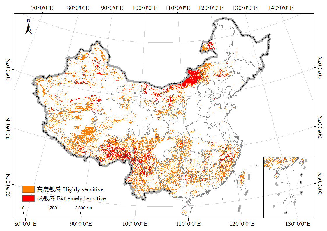
图1 全国生态环境敏感性综合评价分布图
Fig. 1 Comprehensive evaluation of ecological environmental sensitivity in China
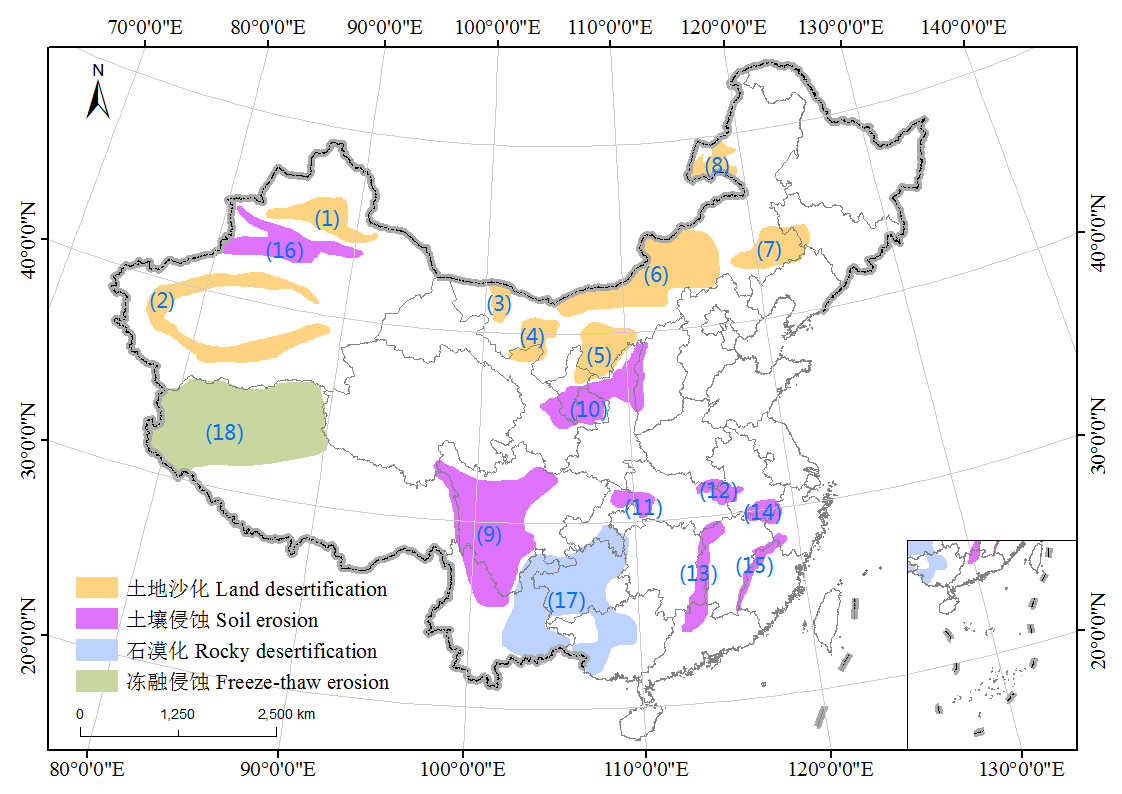
图2 中国生态环境脆弱区空间分布图。(1)古尔班通古特沙漠边缘; (2)塔克拉玛干沙漠边缘; (3)黑河流域中下游; (4)腾格里与乌兰布和沙漠边缘; (5)毛乌素沙地; (6)阴山北麓-浑善达克沙地; (7)科尔沁沙地; (8)呼伦贝尔沙地; (9)横断山; (10)黄土高原丘陵沟壑区; (11)三峡库区; (12)大别山; (13)罗霄山; (14)黄山; (15)仙霞岭-武夷山; (16)天山; (17)西南喀斯特地区; (18)羌塘高原西部。
Fig. 2 Spatial distribution of ecologically vulnerable regions in China. (1) Edge of Gurbantunggut Desert; (2) Edge of Taklimakan Desert; (3) Middle and lower reaches of Heihe River; (4) Edge of Tengger Desert and Wulanbuhe Desert; (5) Mu Us Sandy Land; (6) Northern region of the Yinshan Mountains-Hunshandak Sandy Land; (7) Horqin Sandy Land; (8) Hulun Buir Sandy Land; (9) the Hengduan Mountains; (10) Loess Hilly gully region; (11) Three Gorges Reservoir area; (12) Dabie Mountain; (13) Luoxiao Mountain; (14) Huangshan Mountain; (15) Xianxialing Mountain-Wuyi Mountain; (16) the Tianshan Mountains; (17) Karst Areas in southwestern China; (18) Western part of ChangTang Plateau.
| 1 | Committee of Physical Regionalization of the Chinese Academy of Sciences (中国科学院自然区划工作委员会) (1959) Synthetic Physical Regionalization of China (Draft) (《中国气候区划》(初稿)). Science Press, Beijing. (in Chinese) |
| 2 | Cui SH (崔胜辉), Li FY (李方一), Huang J (黄静), Yu YX (于裕贤) (2009) Review of sensitivity research on the context of global change.Advances in Earth Science(地球科学进展), 24, 1033-1041. (in Chinese with English abstract) |
| 3 | Lan AJ (兰安军), Zhang BP (张百平), Kang KN (熊康宁), An YL (安裕伦) (2003) Spatial pattern of the fragile karst environment in southwest Guizhou province.Geographical Research(地理研究), 22, 733-741. (in Chinese with English abstract) |
| 4 | Liu LY (刘连友), Wang JH (王建华), Li XY (李小雁), Liu YZ (刘玉璋), Tuo WQ (拓万权), Peng HM (彭海梅) (1998) Simulating measurement on the erosive of soil.Chinese Science Bulletin(科学通报), 43, 1663-1666. (in Chinese) |
| 5 | Liu XF (刘宪锋), Ren ZY (任志远), Lin ZH (林志慧), Liu YX (刘炎序), Zhang DH (张东海) (2013) The spatial-temporal changes of vegetation coverage in the Three-River Headwater region in recent 12 years.Acta Geographica Sinica(地理学报), 68, 897-908. (in Chinese with English abstract) |
| 6 | Luo CP (罗承平), Xue JY (薛纪瑜) (1995) Ecologically vulnerable characteristics of the farming-pastoral zigzag zone in northern China.Journal of Arid Land Resources and Environment(干旱区资源与环境), 9, 1-7. (in Chinese with English abstract) |
| 7 | Meng M (孟猛), Ni J (倪健), Zhang ZG (张治国) (2004) Aridity index and its application in geo-ecological study.Acta Phytoecologica Sinica(植物生态学报), 28, 853-861. (in Chinese with English abstract) |
| 8 | Niu WY (牛文元) (1989) The discriminatory index with regard to the weakness, overlapness, and breadth of ecotone.Acta Ecologica Sinica(生态学报), 9, 97-105. (in Chinese with English abstract) |
| 9 | Ouyang ZY (欧阳志云), Wang XK (王效科), Miao H (苗鸿) (2000) China’s eco-environmental sensitivity and its spatial heterogeneity.Acta Ecologica Sinica(生态学报), 20, 9-12. (in Chinese with English abstract) |
| 10 | Pan F (潘峰), Tian CY (田长彦), Shao F (邵峰), Zhou W (周伟), Chen F (陈飞) (2011) Evaluation of ecological sensitivity in Karamay, Xinjiang, Northwest China.Acta Geographica Sinica(地理学报), 66, 1497-1507. (in Chinese with English abstract) |
| 11 | Pan YZ, Shi PJ, Zhu WQ, Gu XH, Fan YD, Li J (2005) Measurement of ecological capital of Chinese terrestrial ecosystem based on remote sensing.Science in China: Series D, 48, 786-796. |
| 12 | Shi DM (史东梅), Chen ZF (陈正发), Jiang GY (蒋光毅), Jiang D (江东) (2012) Comparative study on estimation methods for soil erodibility K in purple hilly area.Journal of Beijing Forestry University(北京林业大学学报), 34(1), 32-38. (in Chinese with English abstract) |
| 13 | Su WC (苏维词), Yang HK (杨汉奎) (1994) Preliminary division of eco-environmental fragility types in Guizhou karst region.Research of Environmental Sciences(环境科学研究), 7, 35-41. (in Chinese with English abstract) |
| 14 | Tian YP (田亚平), Chang H (常昊) (2012) Bibliometric analysis of research progress on ecological vulnerability in China.Acta Geographica Sinica(地理学报), 67, 1515-1525. (in Chinese with English abstract) |
| 15 | Wang RH (王让会), Song YD (宋郁东), Fan ZL (攀自立), You XX (游先祥) (2001) Comprehensive assessment on environmental quality in vulnerable ecotone of Tarim River Basin.Environmental Science(环境科学), 22(2), 7-11. (in Chinese with English abstract) |
| 16 | Wang WZ (王万忠), Jiao JY (焦菊英) (1996) Quantitative evaluation on factors influencing soil erosion in China.Bulletin of Soil and Water Conservation(水土保持通报), 16, 1-20. (in Chinese with English abstract) |
| 17 | Wang XD (王小丹), Zhong XH (钟祥浩), Fan JR (范建容) (2004) Assessment and spatial distribution of sensitivity of soil erosion in Tibet.Acta Geographica Sinica(地理学报), 59, 181-188. (in Chinese with English abstract) |
| 18 | Williams JR, Renard KG, Dyke PT (1983) EPIC: a new method for assessing erosion’s effect on soil productivity.Journal of Soil and Water Conservation, 38, 381-383. |
| 19 | Xiao RB (肖荣波), Ouyang ZY (欧阳志云), Wang XK (王效科), Zhao TQ (赵同谦) (2005) Sensitivity of rocky desertification and its spatial distribution in southwestern China.Chinese Journal of Ecology(生态学杂志), 24, 551-554. (in Chinese with English abstract) |
| 20 | Yu BH (于伯华), Lü CH (吕昌河) (2011) Assessment of ecological vulnerability on the Tibetan Plateau.Geographical Research(地理研究), 30, 2289-2295. (in Chinese with English abstract) |
| 21 | Zhang DF (张殿发), Wang SJ (王世杰), Li RL (李瑞玲), Zhou DQ (周德全) (2002) Eco-geo-environment of rocky desertification and its driving mechanism-a typical example in Karst mountainous areas of Guizhou Province.Rural Eco-Environment(农村生态环境), 18(1), 6-10. (in Chinese with English abstract) |
| 22 | Zhao YL (赵跃龙), Liu YH (刘燕华) (1994) The division of type and decision of range on fragile environment in China.Yunnan Geographic Environment Research(云南地理环境研究), 6(2), 34-44. (in Chinese with English abstract) |
| [1] | 鲁夕霞, 周冯祥, 雍李明, 曾千慧, 赵丽媛, 张语克, 王先艳. 1990-2020年围填海对我国中华白海豚栖息地的影响[J]. 生物多样性, 2026, 34(3): 25249-. |
| [2] | 卢晓强, 董姗姗, 马月, 徐徐, 邱凤, 臧明月, 万雅琼, 李孪鑫, 于赐刚, 刘燕. 前沿技术在生物多样性研究中的应用现状、挑战与展望[J]. 生物多样性, 2025, 33(4): 24440-. |
| [3] | 袁敬毅, 张旭, 田镇朋, 王梓柘, 高永萍, 姚迪昭, 关宏灿, 李文楷, 刘婧, 张宏, 马勤. 结合无人机高分辨率可见光影像和激光雷达点云的城市植物群落树种组成和数量特征提取方法对比[J]. 生物多样性, 2025, 33(4): 24237-. |
| [4] | 武慧, 俞乐, 杜贞容, 赵强, 戚文超, 曹越, 王金洲, 申小莉, 孙尧, 马克平. 基于遥感监测的《昆蒙框架》执行进展快速评估: 路径与展望[J]. 生物多样性, 2025, 33(3): 24526-. |
| [5] | 俞乐, 顾珈同, 武慧, 杜贞容, 李曦煜, 申小莉, 朱丽, 马克平. 面向《昆蒙框架》目标的生物多样性早期预警[J]. 生物多样性, 2025, 33(12): 25329-. |
| [6] | 黄雨菲, 路春燕, 贾明明, 王自立, 苏越, 苏艳琳. 基于无人机影像与面向对象-深度学习的滨海湿地植物物种分类[J]. 生物多样性, 2023, 31(3): 22411-. |
| [7] | 任淯, 陶胜利, 胡天宇, 杨海涛, 关宏灿, 苏艳军, 程凯, 陈梦玺, 万华伟, 郭庆华. 中国生物多样性核心监测指标遥感产品体系构建与思考[J]. 生物多样性, 2022, 30(10): 22530-. |
| [8] | 张昭臣, 胡健波, 杨庆松, 练琚愉, 李步杭, 王希华, 叶万辉, 张健. 中国亚热带4个森林动态监测样地无人机可见光遥感影像数据集[J]. 生物多样性, 2021, 29(9): 1181-1185. |
| [9] | 徐岩, 张聪伶, 降瑞娇, 王子斐, 朱梦晨, 沈国春. 无人机高光谱影像与冠层树种多样性监测[J]. 生物多样性, 2021, 29(5): 647-660. |
| [10] | 李月辉. 大中型兽类种群数量估算的研究进展[J]. 生物多样性, 2021, 29(12): 1700-1717. |
| [11] | 吴漫玲, 姚兰, 艾训儒, 朱江, 朱强, 王进, 黄小, 洪建峰. 水杉原生种群核心种质资源的繁殖特性[J]. 生物多样性, 2020, 28(3): 303-313. |
| [12] | 李顺,邹亮,宫一男,杨海涛,王天明,冯利民,葛剑平. 激光雷达技术在动物生态学领域的研究进展[J]. 生物多样性, 2019, 27(9): 1021-1031. |
| [13] | 孔嘉鑫, 张昭臣, 张健. 基于多源遥感数据的植物物种分类与识别: 研究进展与展望[J]. 生物多样性, 2019, 27(7): 796-812. |
| [14] | 李强, 王彬, 邓云, 林露湘, 达佤扎喜, 张志明. 西双版纳热带雨林林窗空间分布格局及其特征数与林窗下植物多样性的相关性[J]. 生物多样性, 2019, 27(3): 273-285. |
| [15] | 李杰, 李巍岳, 付晶, 高峻, 杨蕾, 何苇航. 基于近低空遥感技术的国家公园功能分区边界识别: 以钱江源国家公园体制试点区为例[J]. 生物多样性, 2019, 27(1): 42-50. |
| 阅读次数 | ||||||
|
全文 |
|
|||||
|
摘要 |
|
|||||
备案号:京ICP备16067583号-7
Copyright © 2026 版权所有 《生物多样性》编辑部
地址: 北京香山南辛村20号, 邮编:100093
电话: 010-62836137, 62836665 E-mail: biodiversity@ibcas.ac.cn
![]()