
Biodiv Sci ›› 2021, Vol. 29 ›› Issue (9): 1181-1185. DOI: 10.17520/biods.2021299 cstr: 32101.14.biods.2021299
• Data Papers • Previous Articles Next Articles
Zhaochen Zhang1, Jianbo Hu2, Qingsong Yang1, Juyu Lian3, Buhang Li4, Xihua Wang1, Wanhui Ye3, Jian Zhang1,*( )
)
Received:2021-07-27
Accepted:2021-09-05
Online:2021-09-20
Published:2021-09-08
Contact:
Jian Zhang
Zhaochen Zhang, Jianbo Hu, Qingsong Yang, Juyu Lian, Buhang Li, Xihua Wang, Wanhui Ye, Jian Zhang. An unmanned aerial vehicle visible light remote sensing image dataset of four forest dynamic plots in subtropical China[J]. Biodiv Sci, 2021, 29(9): 1181-1185.
| 相机设置 Camera setting | 相关参数 Parameters |
|---|---|
| 相机型号 Camera model | SONY NEX-5R |
| 镜头 Camera lens | 16?50 mm |
| 光圈值 The aperture | f/2.8-f/5.6 |
| 曝光时间 Exposure time | 1/1000 |
| ISO 速度 ISO speed | ISO-400 |
| 焦距 Focal length | 35 mm |
| 最大光圈 Maximum aperture | 1.69 |
| 有效像素 Effective pixels/megapixels | 16.1 |
| 照片分辨率 Image resolution | 4912 × 3264 |
| 图片格式 Image format | JPEG |
Table 1 The camera type, settings and photograph parameters equipped with MD-4 1000 quadrotor UAV (unmanned aerial vehicle)
| 相机设置 Camera setting | 相关参数 Parameters |
|---|---|
| 相机型号 Camera model | SONY NEX-5R |
| 镜头 Camera lens | 16?50 mm |
| 光圈值 The aperture | f/2.8-f/5.6 |
| 曝光时间 Exposure time | 1/1000 |
| ISO 速度 ISO speed | ISO-400 |
| 焦距 Focal length | 35 mm |
| 最大光圈 Maximum aperture | 1.69 |
| 有效像素 Effective pixels/megapixels | 16.1 |
| 照片分辨率 Image resolution | 4912 × 3264 |
| 图片格式 Image format | JPEG |
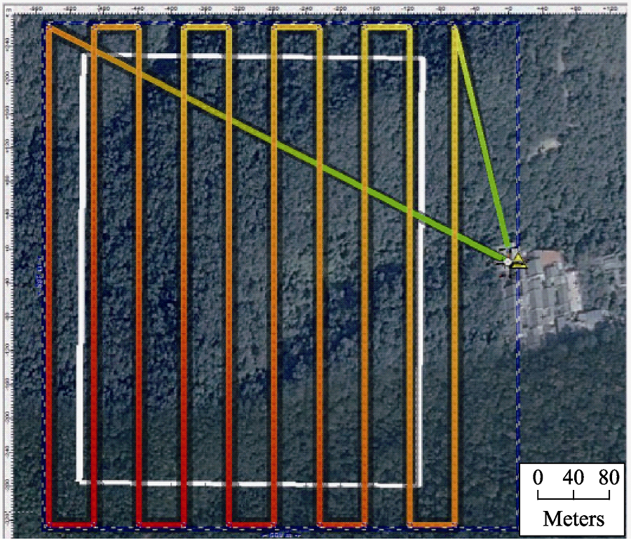
Fig. 1 An example of UAV (unmanned aerial vehicle) mission path
| 样地名称 Site | 经纬度 Location | 年均温 Mean annual temperature (°C) | 年降雨 Annual precipitation (mm) | 海拔 Elevation range (m) | 坡度 Slope (°) | 样地大小 Area (ha) | 物种数 Species richness (DBH ≥ 1 cm) | 总个体数(密度) Total abundance of live trees (Density) |
|---|---|---|---|---|---|---|---|---|
| 浙江天童山 Tiantongshan, Zhejiang | 29°48′ N, 121°47′ E | 16.2 | 1,735 | 304?603 | 13?50 | 20 | 152 | 94,603 (4,730/ha) |
| 浙江百山祖 Baishanzu, Zhejiang | 27°45′ N, 119°13′ E | 12.8 | 2,342 | 1,407?1,646 | 20?35 | 25 | 155 | 224,483 (8,979/ha) |
| 广东车八岭 Chebaling, Guangdong | 24°43′ N, 114°15′ E | 18.1 | 1,900 | 431?545 | 4?53 | 20 | 223 | 86,518 (4,316/ha) |
| 广东鼎湖山 Dinghushan, Guangdong | 23°10′ N, 112°31′ E | 20.9 | 1,985 | 230?470 | 30?50 | 20 | 195 | 80,566 (4,028/ha) |
Table 2 Descriptive statistics for four stem-mapped forest dynamics plots in subtropical regions in China
| 样地名称 Site | 经纬度 Location | 年均温 Mean annual temperature (°C) | 年降雨 Annual precipitation (mm) | 海拔 Elevation range (m) | 坡度 Slope (°) | 样地大小 Area (ha) | 物种数 Species richness (DBH ≥ 1 cm) | 总个体数(密度) Total abundance of live trees (Density) |
|---|---|---|---|---|---|---|---|---|
| 浙江天童山 Tiantongshan, Zhejiang | 29°48′ N, 121°47′ E | 16.2 | 1,735 | 304?603 | 13?50 | 20 | 152 | 94,603 (4,730/ha) |
| 浙江百山祖 Baishanzu, Zhejiang | 27°45′ N, 119°13′ E | 12.8 | 2,342 | 1,407?1,646 | 20?35 | 25 | 155 | 224,483 (8,979/ha) |
| 广东车八岭 Chebaling, Guangdong | 24°43′ N, 114°15′ E | 18.1 | 1,900 | 431?545 | 4?53 | 20 | 223 | 86,518 (4,316/ha) |
| 广东鼎湖山 Dinghushan, Guangdong | 23°10′ N, 112°31′ E | 20.9 | 1,985 | 230?470 | 30?50 | 20 | 195 | 80,566 (4,028/ha) |
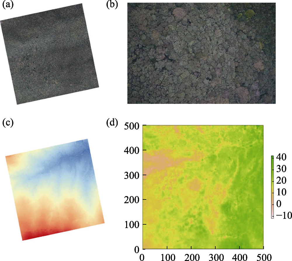
Fig. 2 One example of UAV (unmanned aerial vehicle) visible light remote sensing data. (a) Orthoimages; (b) One of the raw pictures taken by UAV; (c) The map of the digital surface model; and (d) The map of canopy height.
| [1] |
Anderson K, Gaston KJ (2013) Lightweight unmanned aerial vehicles will revolutionize spatial ecology. Frontiers in Ecology and the Environment, 11, 138-146.
DOI URL |
| [2] | Hu JB, Zhang J (2018) Unmanned Aerial Vehicle remote sensing in ecology: Advances and prospects. Acta Ecologica Sinica, 38, 20-30. (in Chinese with English abstract) |
| [胡健波, 张健 (2018) 无人机遥感在生态学中的应用进展. 生态学报, 38, 20-30.] | |
| [3] | Song YC (2013) Evergreen Broad-leaved Forests in China:Classification, Ecology, and Conservation. Science Press, Beijing. (in Chinese) |
| [宋永昌 (2013) 中国常绿阔叶林: 分类·生态·保育. 科学出版社, 北京.] | |
| [4] |
Zhang J, Hu JB, Lian JY, Fan ZJ, Ouyang XJ, Ye WH (2016a) Seeing the forest from drones: Testing the potential of lightweight drones as a tool for long-term forest monitoring. Biological Conservation, 198, 60-69.
DOI URL |
| [5] |
Zhang J, Nielsen SE, Mao LF, Chen SB, Svenning JC (2016b) Regional and historical factors supplement current climate in shaping global forest canopy height. Journal of Ecology, 104, 469-478.
DOI URL |
| [1] | Li Huang, Zhifa Liu, Yuening Gong, Buhang Li, Jian Zhang. Plant community composition and structure of sixteen 1-ha forest dynamics monitoring plots of Nanling Mountains in Guangdong Province [J]. Biodiv Sci, 2026, 34(3): 25357-. |
| [2] | Shiyun Yang, Lujie Hu, Qinxiu Huang, Shiqi Zeng, Jiajun Wang, Tong Zhang, Cancan Zhang, Wensheng Bu. Post-snowstorm community dynamics in an evergreen broad-leaved forest of Jiulian Mountains, Jiangxi Province [J]. Biodiv Sci, 2025, 33(9): 25005-. |
| [3] | Yun’ao Li, Wenfu Zhang, Guigang Zhao, Chunyan Yang, Xiangqing Chen, Shengdong Yuan, Min Cao, Wang Cai, Jie Yang. Application of airborne eDNA for terrestrial animal diversity monitoring: A case study of 20-ha forest dynamics plot in Xishuangbanna, Yunnan, China [J]. Biodiv Sci, 2025, 33(6): 24318-. |
| [4] | Li Yanpeng, Chen Jie, Lu Chunyang, Xu Han. Community characteristics of a 64-ha secondary forest dynamics plot in a tropical montane rainforest in Jianfengling, Hainan [J]. Biodiv Sci, 2025, 33(2): 24445-. |
| [5] | Jia Zhenni, Zhang Yicen, Du Yanjun, Ren Haibao. Influences of disturbances on successional dynamics of species diversity in mid- subtropical forests [J]. Biodiv Sci, 2025, 33(2): 24078-. |
| [6] | Zichen Hong, Yuanguang Yang, Xinhao Huang, Zi Wang, Xiao Zheng, Xu Zhou, Yan Zhou, Shipin Chen, Wenjun Lin. Changes and driving mechanism of biomass in evergreen broad-leaved forests in Wuyishan National Park [J]. Biodiv Sci, 2025, 33(11): 25181-. |
| [7] | Jiaxin Wei, Zhiguo Jiang, Linsen Yang, Huanhuan Xiong, Jiaojiao Jin, Fanglin Luo, Jiehua Li, Hao Wu, Yaozhan Xu, Xiujuan Qiao, Xinzeng Wei, Hui Yao, Huiliang Yu, Jingyuan Yang, Mingxi Jiang. Community composition and structure in a 25 ha mid-subtropical mountain deciduous broad-leaved forest dynamics plot in Shennongjia, Hubei, China [J]. Biodiv Sci, 2024, 32(3): 23338-. |
| [8] | Xiaolin Liu, Yougui Wu, Minhua Zhang, Xiaorong Chen, Zhicheng Zhu, Dingyun Chen, Shu Dong, Buhang Li, Bingyang Ding, Yu Liu. Community composition and structure of a 25-ha forest dynamics plot of subtropical forest in Baishanzu, Zhejiang Province [J]. Biodiv Sci, 2024, 32(2): 23294-. |
| [9] | Mingmiao Chen, Churan Zhang, Yun Deng, Shengfa Li, Fengchang Li, Zhizhong Tang, Zhaozhe Wei, Caicai Zhang, Luxiang Lin. Effect of topographic factors on sprouting characteristics of woody plants in subtropical semi-humid evergreen broad-leaved forests [J]. Biodiv Sci, 2024, 32(12): 24282-. |
| [10] | Jia Yao, Congling Zhang, Shixuan Li, Yang Lin, Zhen Wang, Yuhan Zhang, Weilong Zhou, Xinhe Pan, Shan Zhu, Yiqing Wu, Dan Wang, Jinliang Liu, Shanshan Tan, Guochun Shen, Mingjian Yu. Characteristics of plant communities in the Baishanzu continuous elevational transect [J]. Biodiv Sci, 2024, 32(12): 24052-. |
| [11] | Hang Shan, Zupei Lei, Fangdong Zheng, Boliang Wei, Lei Zhong, Mingjian Yu. Dynamic changes in the community of a secondary evergreen broad-leaved forest in Wuyanling, Zhejiang Province from 2013 to 2023 [J]. Biodiv Sci, 2024, 32(12): 24372-. |
| [12] | Kailun Xu, Xiaorong Chen, Minhua Zhang, Wanwan Yu, Sumei Wu, Zhicheng Zhu, Dingyun Chen, Rongguang Lan, Shu Dong, Yu Liu. Succession and topography jointly influence the diversity of plant sexual systems in the Baishanzu forest community [J]. Biodiv Sci, 2024, 32(12): 24338-. |
| [13] | Churan Zhang, Shengfa Li, Fengchang Li, Zhizhong Tang, Huiyan Liu, Lihong Wang, Rong Gu, Yun Deng, Zhiming Zhang, Luxiang Lin. Habitat association and community classification of woody plants in the 20 ha forest dynamics plot of subtropical semi-humid evergreen broad-leaved forest in the Jizu Mountains, Yunnan [J]. Biodiv Sci, 2024, 32(1): 23393-. |
| [14] | Minghui Wang, Zhaoquan Chen, Shuaifeng Li, Xiaobo Huang, Xuedong Lang, Zihan Hu, Ruiguang Shang, Wande Liu. Spatial pattern of dominant species with different seed dispersal modes in a monsoon evergreen broad-leaved forest in Pu’er, Yunnan Province [J]. Biodiv Sci, 2023, 31(9): 23147-. |
| [15] | Shengwen Chen, Haibao Ren, Guangrong Tong, Ningning Wang, Wenchao Lan, Jianhua Xue, Xiangcheng Mi. Spatial patterns in woody species diversity in the Qianjiangyuan National Park [J]. Biodiv Sci, 2023, 31(7): 22587-. |
| Viewed | ||||||
|
Full text |
|
|||||
|
Abstract |
|
|||||
Copyright © 2026 Biodiversity Science
Editorial Office of Biodiversity Science, 20 Nanxincun, Xiangshan, Beijing 100093, China
Tel: 010-62836137, 62836665 E-mail: biodiversity@ibcas.ac.cn