
生物多样性 ›› 2024, Vol. 32 ›› Issue (12): 24239. DOI: 10.17520/biods.2024239 cstr: 32101.14.biods.2024239
吴芳芳, 刘娜, 何春梅, 原作强, 郝占庆, 尹秋龙*( )
)
收稿日期:2024-06-17
接受日期:2024-10-13
出版日期:2024-12-20
发布日期:2024-12-28
通讯作者:
E-mail: 基金资助:
Fangfang Wu, Na Liu, Chunmei He, Zuoqiang Yuan, Zhanqing Hao, Qiulong Yin*()
Received:2024-06-17
Accepted:2024-10-13
Online:2024-12-20
Published:2024-12-28
Contact:
E-mail: Supported by:摘要: 研究植物群落结构及多样性格局有利于揭示生物多样性维持机制。秦岭处于南北气候分界线和动植物区系的交汇过渡带, 区系成分丰富且起源古老, 植被类型多样, 群落结构复杂, 是研究过渡区植物群落结构及多样性分布格局的重要平台。参照美国史密森热带研究院热带森林研究中心的样地建设标准, 我们以秦岭皇冠25 ha大样地为核心, 在秦岭南坡中段海拔800-2,600 m地段设置10个1 ha (100 m × 100 m)的长期定位监测样地并进行群落调查, 对胸径(diameter at breast height, DBH) ≥ 1 cm的木本植物物种组成、区系特征、径级结构、优势种空间分布和物种多样性的海拔梯度格局进行初步研究。结果表明: (1)共调查到种子植物208种, 分属50科109属。温带区系成分的属占总属数的69.7%, 温带区系特征明显。随海拔上升, 植物群落稀有种、偶见种及科、属、种组成呈现先上升后下降的单峰格局。群落优势种沿海拔梯度具有明显的更替现象, 中海拔呈现阔叶栎林与针叶杉林过渡性质。(2)所有样地内木本植物径级分布总体呈倒“J”型。分海拔来看, 除了海拔1,600 m、2,000 m木本植物径级分布呈现双峰型, 其余海拔均呈现倒“J”型, 群落结构总体较为稳定。优势种在不同海拔空间点格局表现为1-10 m尺度内聚集分布, 随着尺度的增加, 逐渐转变为随机分布和均匀分布。随着海拔的升高, 去除生境异质性后, 聚集分布的尺度范围缩小, 随机分布的尺度范围增大。(3)随海拔上升, 物种丰富度呈显著的单峰分布格局, 峰值出现在海拔1,200-1,400 m之间。Shannon-Wiener多样性指数、Simpson优势度指数、Pielou均匀度指数沿海拔梯度的变化呈显著的双峰格局, 两个峰值均出现在海拔1,000-1,200 m和海拔2,000-2,200 m。β多样性(Bray-Curtis相异指数和Jaccard相异指数)随海拔的升高呈现单峰趋势。本文为亚热带-暖温带过渡区森林长期监测和基础数据库建设奠定了基础, 同时为该过渡区生物多样性保护和森林可持续经营提供了理论支持。
吴芳芳, 刘娜, 何春梅, 原作强, 郝占庆, 尹秋龙 (2024) 秦岭山地木本植物群落结构及多样性的海拔梯度格局. 生物多样性, 32, 24239. DOI: 10.17520/biods.2024239.
Fangfang Wu, Na Liu, Chunmei He, Zuoqiang Yuan, Zhanqing Hao, Qiulong Yin (2024) Elevational gradient pattern of woody plant community structure and diversity in the Qinling Mountains. Biodiversity Science, 32, 24239. DOI: 10.17520/biods.2024239.
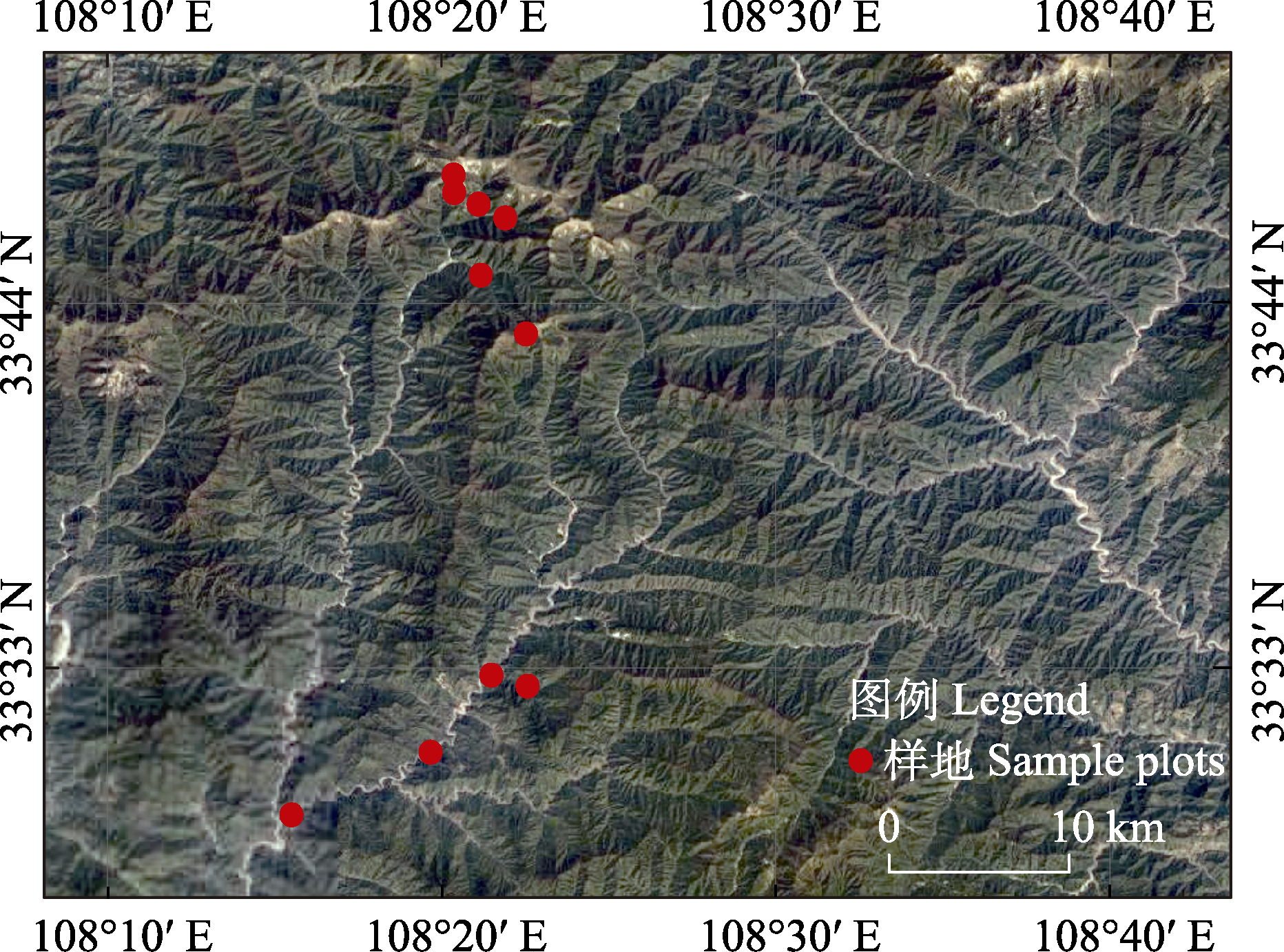
图1 研究区域和海拔样地分布图
Fig. 1 Map of the study area and elevation sample plots
| 样地编号 Plot no. | ||||||||||
|---|---|---|---|---|---|---|---|---|---|---|
| P1 | P2 | P3 | P4 | P5 | P6 | P7 | P8 | P9 | P10 | |
| 海拔 Elevation (m) | 800 | 1,000 | 1,200 | 1,400 | 1,600 | 1,800 | 2,000 | 2,200 | 2,400 | 2,600 |
| 坡度 Slope (°) | 32 | 23 | 32 | 29 | 26 | 24 | 13 | 24 | 25 | 16 |
| 坡向 Aspect (°) | 254 | 210 | 327 | 267 | 156 | 190 | 317 | 307 | 268 | 186 |
| 最大胸径 Maximun diameter at breast height (cm) | 56.0 | 57.5 | 78.0 | 71.8 | 66.7 | 55.0 | 62.1 | 58.2 | 53.9 | 58.5 |
| 平均胸径 Mean diameter at breast height (cm) | 8.13 | 8.07 | 7.11 | 5.76 | 14.25 | 11.35 | 13.90 | 5.99 | 6.72 | 22.49 |
| 胸高断面积之和 Sum of basal area (m2) | 30.28 | 53.54 | 33.37 | 39.61 | 48.83 | 57.95 | 28.74 | 28.83 | 12.75 | 23.48 |
| 立木密度 Stand density (ind./km2) | 3,562 | 3,869 | 3,488 | 5,033 | 1,981 | 3,078 | 1,193 | 3,878 | 1,708 | 503 |
| 种数 No. of species (S) | 39 | 53 | 80 | 79 | 57 | 60 | 46 | 49 | 39 | 18 |
| 属数 No. of genera | 33 | 46 | 54 | 59 | 43 | 41 | 31 | 30 | 26 | 13 |
| 科数 No. of families | 23 | 29 | 35 | 35 | 26 | 26 | 18 | 20 | 16 | 8 |
| Shannon-Wiener多样性指数 Shannon-Wiener diversity index (H') | 1.83 | 3.00 | 3.09 | 3.01 | 2.92 | 3.26 | 3.03 | 2.86 | 2.33 | 1.52 |
| Simpson优势度指数 Simpson dominance index (D) | 0.76 | 0.93 | 0.93 | 0.90 | 0.90 | 0.93 | 0.94 | 0.91 | 0.83 | 0.68 |
| Pielou均匀度指数 Pielou evenness index (E) | 0.49 | 0.76 | 0.70 | 0.69 | 0.72 | 0.80 | 0.79 | 0.73 | 0.64 | 0.52 |
表1 海拔样地调查信息
Table 1 Information on elevation survey sample plots
| 样地编号 Plot no. | ||||||||||
|---|---|---|---|---|---|---|---|---|---|---|
| P1 | P2 | P3 | P4 | P5 | P6 | P7 | P8 | P9 | P10 | |
| 海拔 Elevation (m) | 800 | 1,000 | 1,200 | 1,400 | 1,600 | 1,800 | 2,000 | 2,200 | 2,400 | 2,600 |
| 坡度 Slope (°) | 32 | 23 | 32 | 29 | 26 | 24 | 13 | 24 | 25 | 16 |
| 坡向 Aspect (°) | 254 | 210 | 327 | 267 | 156 | 190 | 317 | 307 | 268 | 186 |
| 最大胸径 Maximun diameter at breast height (cm) | 56.0 | 57.5 | 78.0 | 71.8 | 66.7 | 55.0 | 62.1 | 58.2 | 53.9 | 58.5 |
| 平均胸径 Mean diameter at breast height (cm) | 8.13 | 8.07 | 7.11 | 5.76 | 14.25 | 11.35 | 13.90 | 5.99 | 6.72 | 22.49 |
| 胸高断面积之和 Sum of basal area (m2) | 30.28 | 53.54 | 33.37 | 39.61 | 48.83 | 57.95 | 28.74 | 28.83 | 12.75 | 23.48 |
| 立木密度 Stand density (ind./km2) | 3,562 | 3,869 | 3,488 | 5,033 | 1,981 | 3,078 | 1,193 | 3,878 | 1,708 | 503 |
| 种数 No. of species (S) | 39 | 53 | 80 | 79 | 57 | 60 | 46 | 49 | 39 | 18 |
| 属数 No. of genera | 33 | 46 | 54 | 59 | 43 | 41 | 31 | 30 | 26 | 13 |
| 科数 No. of families | 23 | 29 | 35 | 35 | 26 | 26 | 18 | 20 | 16 | 8 |
| Shannon-Wiener多样性指数 Shannon-Wiener diversity index (H') | 1.83 | 3.00 | 3.09 | 3.01 | 2.92 | 3.26 | 3.03 | 2.86 | 2.33 | 1.52 |
| Simpson优势度指数 Simpson dominance index (D) | 0.76 | 0.93 | 0.93 | 0.90 | 0.90 | 0.93 | 0.94 | 0.91 | 0.83 | 0.68 |
| Pielou均匀度指数 Pielou evenness index (E) | 0.49 | 0.76 | 0.70 | 0.69 | 0.72 | 0.80 | 0.79 | 0.73 | 0.64 | 0.52 |
| 分布区类型 Distribution area types | 属数 No. of genera (%) |
|---|---|
| 1. 世界分布 Cosmopolitan | 2 (1.8) |
| 2. 泛热带分布 Pantropic | 8 (7.3) |
| 3. 热带亚洲和热带美洲间断分布 Tropical Asia and Tropical American disjuncted | 5 (4.6) |
| 4. 旧世界热带分布 Old World Tropic | 2 (1.8) |
| 5. 热带亚洲至热带澳大利亚分布 Tropical Asia and Tropical Australia | 3 (2.8) |
| 6. 热带亚洲分布 Tropical Asia | 6 (5.5) |
| 热带小计 Tropical subtotal (2-6) | 24 (22.1) |
| 7. 北温带分布 North Temperate | 43 (39.4) |
| 8. 东亚和北美间断分布 East Asia and North America disjuncted | 13 (11.9) |
| 9. 旧世界温带分布 Old World Temperate | 3 (2.8) |
| 10. 温带亚洲分布 Temperate Asia | 1 (0.9) |
| 11. 地中海、西至中亚分布 Mediterranean, West Asia to Central Asia | 1 (0.9) |
| 12. 东亚分布 East Asia | 15 (13.8) |
| 温带小计 Temperate subtotal (7-12) | 76 (69.7) |
| 13. 特有分布 Endemic to China | 7 (6.4) |
| 合计 Total | 109 (100.0) |
表2 秦岭南坡中段海拔样地所有木本植物属的区系组成
Table 2 Floristic composition of all genera of woody plants in all elevation plots in the middle section of the southern slope of Qinling Mountains
| 分布区类型 Distribution area types | 属数 No. of genera (%) |
|---|---|
| 1. 世界分布 Cosmopolitan | 2 (1.8) |
| 2. 泛热带分布 Pantropic | 8 (7.3) |
| 3. 热带亚洲和热带美洲间断分布 Tropical Asia and Tropical American disjuncted | 5 (4.6) |
| 4. 旧世界热带分布 Old World Tropic | 2 (1.8) |
| 5. 热带亚洲至热带澳大利亚分布 Tropical Asia and Tropical Australia | 3 (2.8) |
| 6. 热带亚洲分布 Tropical Asia | 6 (5.5) |
| 热带小计 Tropical subtotal (2-6) | 24 (22.1) |
| 7. 北温带分布 North Temperate | 43 (39.4) |
| 8. 东亚和北美间断分布 East Asia and North America disjuncted | 13 (11.9) |
| 9. 旧世界温带分布 Old World Temperate | 3 (2.8) |
| 10. 温带亚洲分布 Temperate Asia | 1 (0.9) |
| 11. 地中海、西至中亚分布 Mediterranean, West Asia to Central Asia | 1 (0.9) |
| 12. 东亚分布 East Asia | 15 (13.8) |
| 温带小计 Temperate subtotal (7-12) | 76 (69.7) |
| 13. 特有分布 Endemic to China | 7 (6.4) |
| 合计 Total | 109 (100.0) |
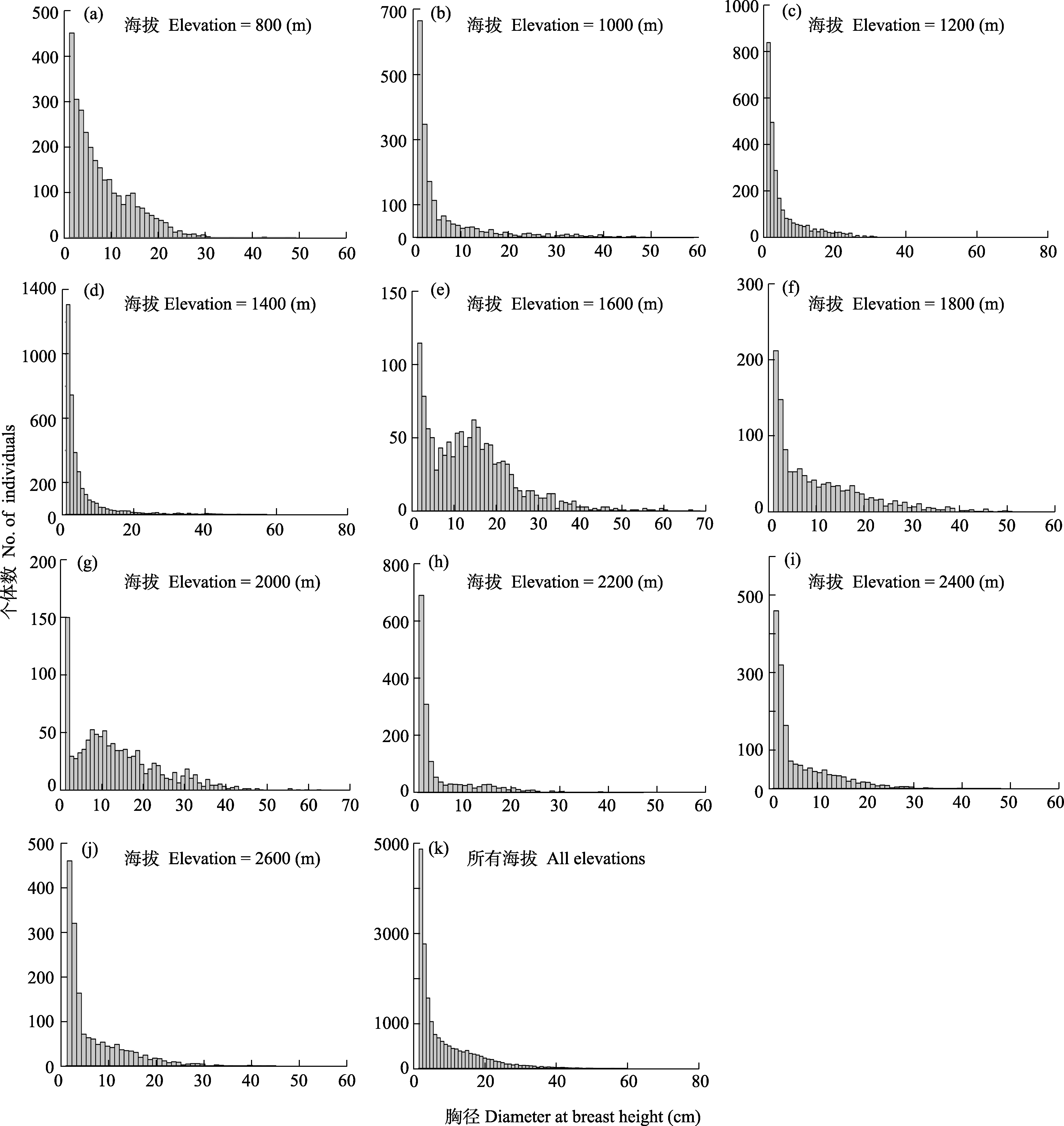
图2 秦岭南坡中段各海拔样地木本植物径级分布及总体径级分布
Fig. 2 Diameter class distribution of woody plants and the overall diameter class distribution along elevational gradients in the middle section of the southern slope of Qinling Mountains
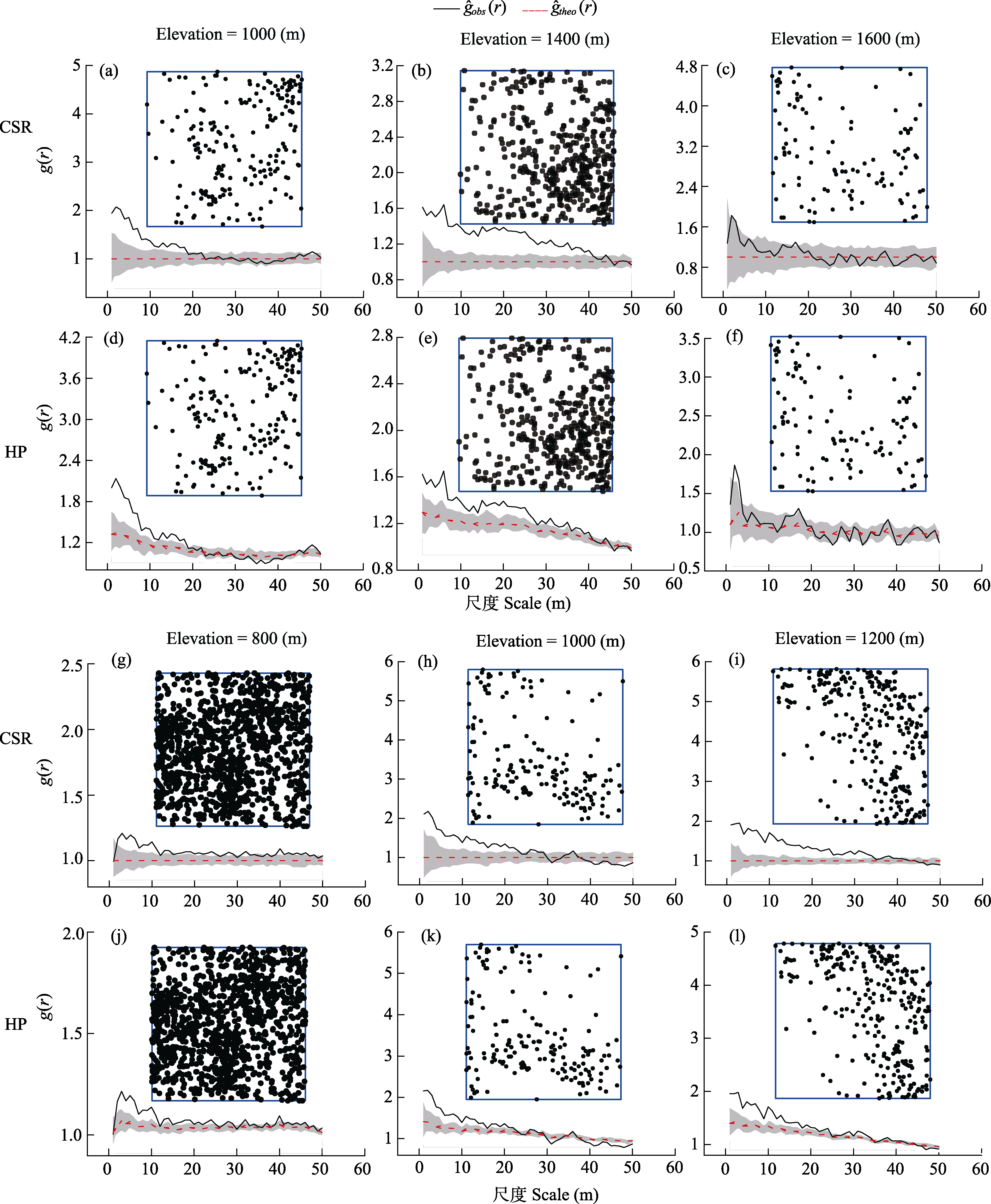
图3 锐齿槲栎(a-f)和栓皮栎(g-l)沿海拔梯度在完全随机模型(CSR)和异质泊松模型(HP)的空间分布。g^obs (r): g(r)的观测值; g^theo (r): g(r)的理论值; 灰色部分为99%置信区间。
Fig. 3 Spatial distribution pattern of Quercus aliena var. acutiserrata (a-f) and Q. variabilis (g-l) under complete spatial randomness (CSR) model and heterogeneous Poisson (HP) model along elevational gradients. g^obs (r), Observed value of g(r); g^theo (r), Theoretical value of g(r); Gray part is the 99% confidence interval.
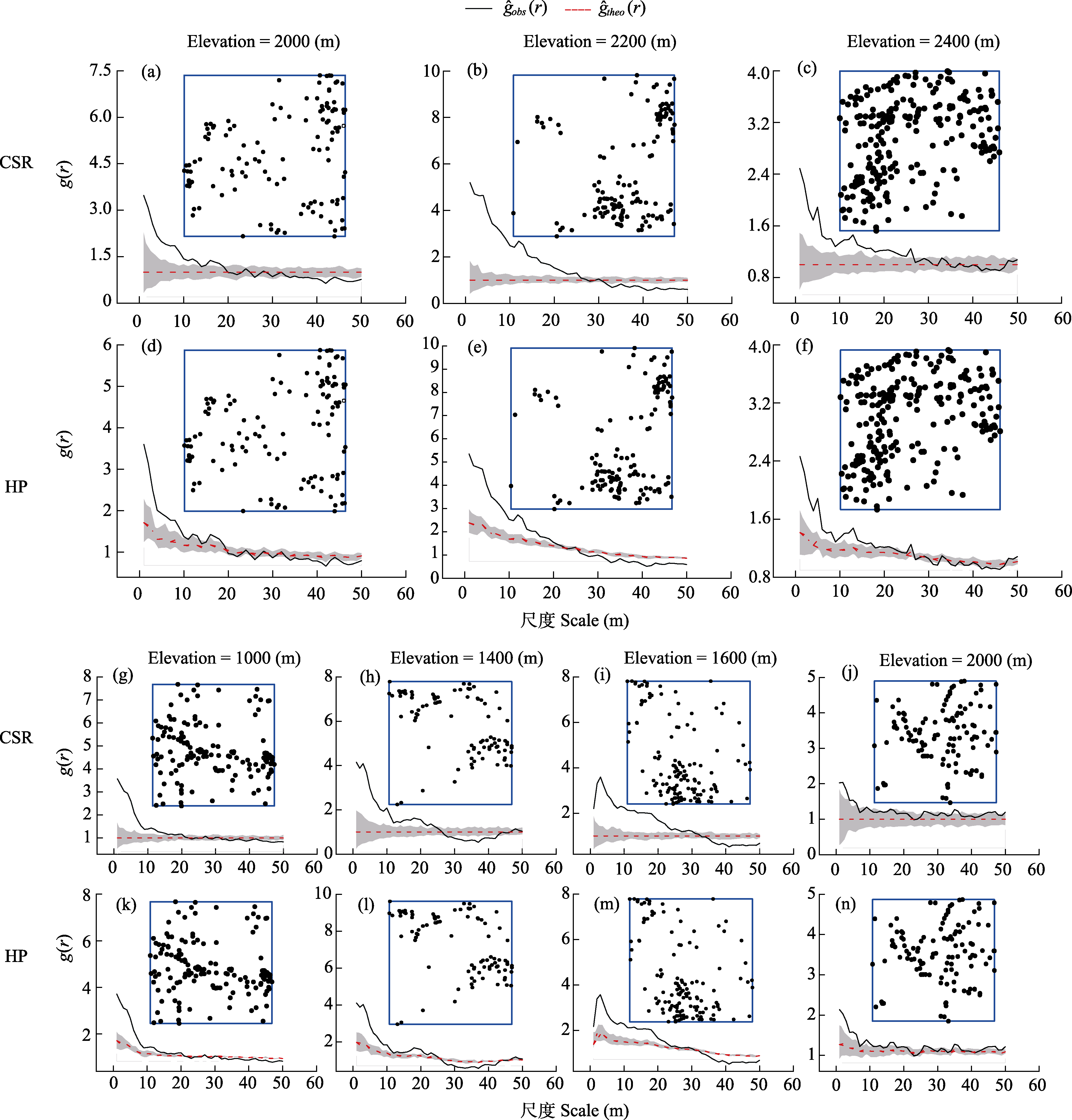
图4 华山松(a-f)和油松(g-n)沿海拔梯度在完全随机模型(CSR)和异质泊松模型(HP)的空间分布。g^obs (r): g(r)的观测值; g^theo (r): g(r)的理论值; 灰色部分为99%置信区间。
Fig. 4 Spatial distribution pattern of Pinus armandii (a-f) and P. tabuliformis (g-n) under complete spatial randomness (CSR) null model and heterogeneous Poisson (HP) null model along elevational gradients. g^obs (r), Observed value of g(r); g^theo (r), Theoretical value of g(r); Gray part is the 99% confidence interval.
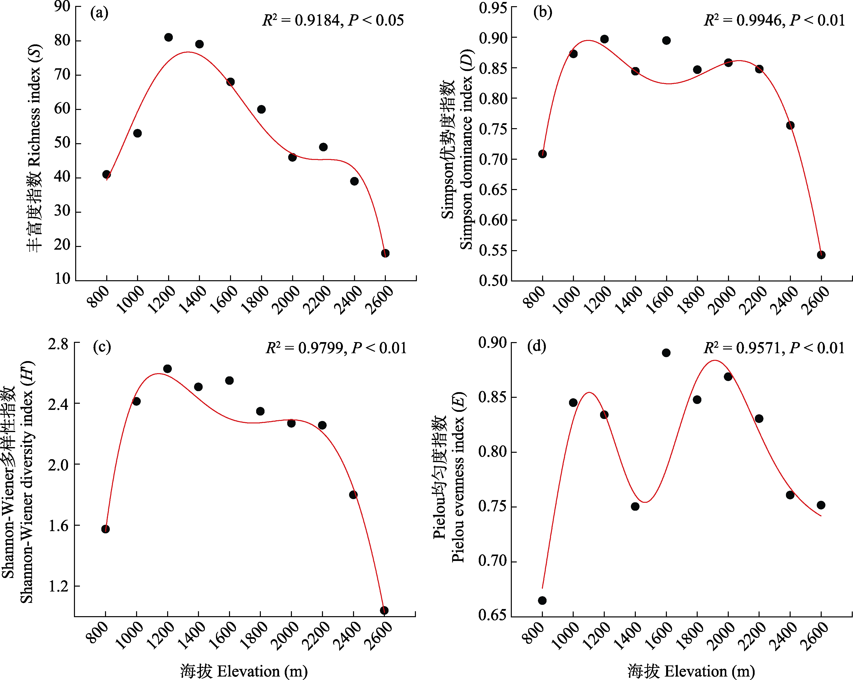
图5 秦岭南坡中段沿海拔梯度群落丰富度指数(a)、Simpson优势度指数(b)、Shannon-Wiener多样性指数(c)、Pielou均匀度指数(d)的变化。R2表示模型拟合优度; P < 0.05表示结果具有统计显著性。
Fig. 5 Changes in species richness (a), Simpson dominance index (b), Shannon-Wiener diversity index (c) and Pielou evenness index (d) along an elevational gradient in the middle section of the southern slope of Qinling Mountains. R2 indicates the goodness of fit of the model and P < 0.05 indicates that the results are statistically significant.
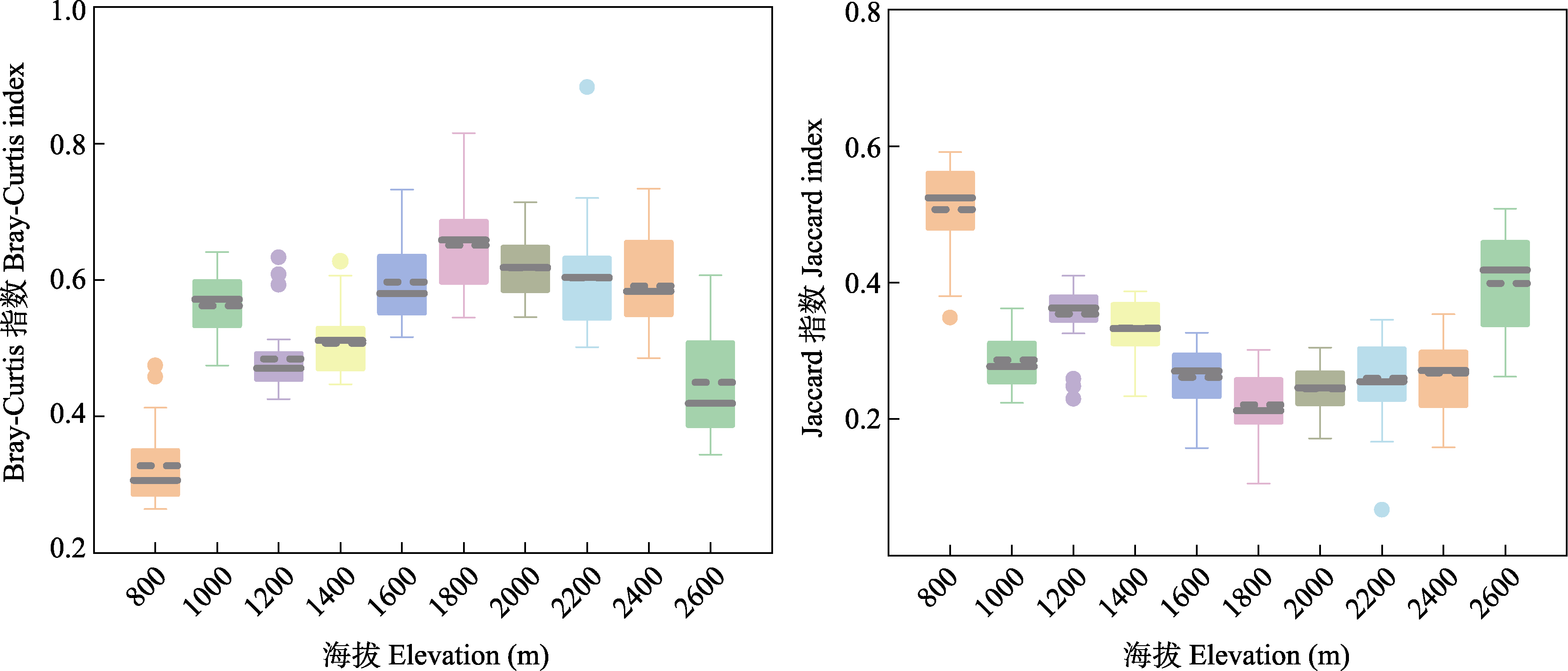
图6 秦岭南坡中段沿海拔Bray-Curtis相异指数和Jaccard相异指数的变化趋势
Fig. 6 Changes in Bray-Curtis index and Jaccard index along an elevational gradient in the middle section of the southern slope of Qinling Mountains
| [1] | Anderegg WRL, Klein T, Bartlett M, Sack L, Pellegrini AFA, Choat B, Jansen S (2016) Meta-analysis reveals that hydraulic traits explain cross-species patterns of drought- induced tree mortality across the globe. Proceedings of the National Academy of Sciences, USA, 113, 5024-5029. |
| [2] |
Anderson MJ, Crist TO, Chase JM, Vellend M, Inouye BD, Freestone AL, Sanders NJ, Cornell HV, Comita LS, Davies KF, Harrison SP, Kraft NJB, Stegen JC, Swenson NG (2011) Navigating the multiple meanings of β diversity: A roadmap for the practicing ecologist. Ecology Letters, 14, 19-28.
DOI PMID |
| [3] | Anderson-Teixeira KJ, Davies SJ, Bennett AC, Gonzalez-Akre EB, Muller-Landau HC, Wright SJ, Abu Salim K, Almeyda Zambrano AM, Alonso A, Baltzer JL, Basset Y, Bourg NA, Broadbent EN, Brockelman WY, Bunyavejchewin S, Burslem DFRP, Butt N, Cao M, Cardenas D, Chuyong GB, Clay K, Cordell S, Dattaraja HS, Deng XB, Detto M, Du XJ, Duque A, Erikson DL, Ewango CEN, Fischer GA, Fletcher C, Foster RB, Giardina CP, Gilbert GS, Gunatilleke N, Gunatilleke S, Hao ZQ, Hargrove WW, Hart TB, Hau BCH, He FL, Hoffman FM, Howe RW, Hubbell SP, Inman-Narahari FM, Jansen PA, Jiang MX, Johnson DJ, Kanzaki M, Kassim AR, Kenfack D, Kibet S, Kinnaird MF, Korte L, Kral K, Kumar J, Larson AJ, Li YD, Li XK, Liu SR, Lum SKY, Lutz JA, Ma KP, Maddalena DM, Makana JR, Malhi Y, Marthews T, Serudin RM, McMahon SM, McShea WJ, Memiaghe HR, Mi XC, Mizuno T, Morecroft M, Myers JA, Novotny V, de Oliveira AA, Ong PS, Orwig DA, Ostertag R, den Ouden J, Parker GG, Phillips RP, Sack L, Sainge MN, Sang WG, Sri-Ngernyuang K, Sukumar R, Sun IF, Sungpalee W, Suresh HS, Tan S, Thomas SC, Thomas DW, Thompson J, Turner BL, Uriarte M, Valencia R, Vallejo MI, Vicentini A, Vrška T, Wang XH, Wang XG, Weiblen G, Wolf A, Xu H, Yap S, Zimmerman J (2015) CTFS-ForestGEO: A worldwide network monitoring forests in an era of global change. Global Change Biology, 21, 528-549. |
| [4] | Baddeley A, Turner R (2005) spatstat: An R package for analyzing spatial point patterns. Journal of Statistical Software, 12, 1-42. |
| [5] | Carrer M, Castagneri D, Popa I, Pividori M, Lingua E (2018) Tree spatial patterns and stand attributes in temperate forests: The importance of plot size, sampling design, and null model. Forest Ecology and Management, 407, 125-134. |
| [6] | Chen L, An MT, Ren JJ, Pan DY, Ye C, Cui XY, Huang L, Jin Y (2020) Species diversity of plant communities and interspecific connectivity of main trees in the rocky desertification area of the Beipanjiang River in Guizhou Province. Journal of Southwest University (Natural Science Edition), 42(5), 80-94. (in Chinese with English abstract) |
| [陈龙, 安明态, 任娇娇, 潘端云, 叶超, 崔兴勇, 黄郎, 金勇 (2020) 贵州北盘江石漠化区植物群落物种多样性及主要乔木种间联结性. 西南大学学报(自然科学版), 42(5), 80-94.] | |
| [7] | Chen SF, Xu H, Lin WJ, Zheng X, Xu XJ, Liu WF, Ding H, Chen SP (2023) Variation analysis on species diversity of plant communities along the elevation gradient in Wuyishan National Park. Journal of Plant Resources and Environment, 32, 1-9. (in Chinese with English abstract) |
| [陈水飞, 徐辉, 林文俊, 郑笑, 徐鲜钧, 刘文芳, 丁晖, 陈世品 (2023) 武夷山国家公园植物群落物种多样性沿海拔梯度的变化分析. 植物资源与环境学报, 32, 1-9.] | |
| [8] |
Chen SW, Ren HB, Tong GR, Wang NN, Lan WC, Xue JH, Mi XC (2023) Spatial patterns in woody species diversity in the Qianjiangyuan National Park. Biodiversity Science, 31, 22587. (in Chinese with English abstract)
DOI |
|
[陈声文, 任海保, 童光蓉, 王宁宁, 蓝文超, 薛建华, 米湘成 (2023) 钱江源国家公园木本植物物种多样性空间分布格局. 生物多样性, 31, 22587.]
DOI |
|
| [9] | Chen T, Liang HL, Huo CL, Luo YH (2024) Dynamic of community structure in middle mountain evergreen and deciduous broad-leaved mixed forest in Cenwanglaoshan. Guihaia, 44, 1917-1930. (in Chinese with English abstract) |
| [陈韬, 梁火连, 霍春霖, 罗应华 (2024) 岑王老山中山常绿落叶阔叶混交林群落结构动态. 广西植物, 44, 1917-1930.] | |
| [10] | Chen Y, Guo L, Yao CL, Wei BL, Yuan ZL, Ye YZ (2017) Community characteristics of a deciduous broad-leaved forest in a temperate-subtropical ecological transition zone: Analyses of a 5-hm2 forest dynamics plot in Baiyunshan Nature Reserve, Henan Province. Acta Ecologica Sinica, 37, 5602-5611. (in Chinese with English abstract) |
| [陈云, 郭凌, 姚成亮, 韦博良, 袁志良, 叶永忠 (2017) 暖温带-北亚热带过渡区落叶阔叶林群落特征. 生态学报, 37, 5602-5611.] | |
| [11] | Chen Y, Wang HL, Han JW, Wei BL, Jia HR, Ye YZ, Yuan ZL (2014) Numerical classification, ordination and species diversity along elevation gradients of the forest community in Xiaoqinling. Acta Ecologica Sinica, 34, 2068-2075. (in Chinese with English abstract) |
| [陈云, 王海亮, 韩军旺, 韦博良, 贾宏汝, 叶永忠, 袁志良 (2014) 小秦岭森林群落数量分类、排序及多样性垂直格局. 生态学报, 34, 2068-2075.] | |
| [12] | Condit R (1998) Tropical Forest Census Plots: Methods and Results from Barro colorado Island, Panama and a Comparison with other Plots. Springer-Verlag, Berlin. |
| [13] |
Condit R, Ashton PS, Baker P, Bunyavejchewin S, Gunatilleke S, Gunatilleke N, Hubbell SP, Foster RB, Itoh A, LaFrankie JV, Lee HS, Losos E, Manokaran N, Sukumar R, Yamakura T (2000) Spatial patterns in the distribution of tropical tree species. Science, 288, 1414-1418.
DOI PMID |
| [14] | Fang JY (2004) Exploring altitudinal patterns of plant diversity of China’s mountains. Biodiversity Science, 12, 1-4. (in Chinese) |
|
[方精云 (2004) 探索中国山地植物多样性的分布规律. 生物多样性, 12, 1-4.]
DOI |
|
| [15] | Fu ZJ, Zhang XY, Liu SY, Tao M (1996) The summarize of research on the flora and vegetation of the Qinling Mountain range. Acta Botanica Boreali-Occidentalia Sinica, 17, 93-106. (in Chinese with English abstract) |
| [傅志军, 张行勇, 刘顺义, 陶铭 (1996) 秦岭植物区系和植被研究概述. 西北植物学报, 17, 93-106.] | |
| [16] | Gaston KJ (2000) Global patterns in biodiversity. Nature, 405, 220-227. |
| [17] |
Gu L, O’Hara KL, Li WZ, Gong ZW (2019) Spatial patterns and interspecific associations among trees at different stand development stages in the natural secondary forests on the Loess Plateau, China. Ecology and Evolution, 9, 6410-6421.
DOI |
| [18] | Gu R, Zhang CC, He ZH, Yang R, Chen Y, Feng P, Sina QZ, Zhao DL, Yixi YC, Wu JH, Lin LX (2021) Population spatial distribution pattern and association of Abies georgei in Shangri-La Potatso National Park. Chinese Journal of Ecology, 40, 3860-3869. (in Chinese with English abstract) |
| [顾荣, 张彩彩, 和正华, 杨荣, 陈瑶, 冯萍, 斯那取宗, 赵冬莲, 益西央初, 吴俊华, 林露湘 (2021) 香格里拉普达措国家公园长苞冷杉种群空间分布格局及关联性. 生态学杂志, 40, 3860-3869.] | |
| [19] | Guariguata MR, Ostertag R (2001) Neotropical secondary forest succession: Changes in structural and functional characteristics. Forest Ecology and Management, 148, 185-206. |
| [20] | Guo YL, Wang B, Xiang WS, Ding T, Lu SH, Huang FZ, Wen SJ, Li DX, He YL, Li XK (2016) Responses of spatial pattern of woody plants’ basal area to topographic factors in a tropical Karst seasonal rainforest in Nonggang, Guangxi, Southern China. Biodiversity Science, 24, 30-39. (in Chinese with English abstract) |
|
[郭屹立, 王斌, 向悟生, 丁涛, 陆树华, 黄甫昭, 文淑均, 李冬兴, 何运林, 李先琨 (2016) 喀斯特季节性雨林木本植物胸高断面积分布格局及其对地形因子的响应. 生物多样性, 24, 30-39.]
DOI |
|
| [21] | Han AX, Qiu J, He CM, Yin QL, Jia SH, Luo Y, Li CL, Hao ZQ (2022) Spatial distribution patterns and intraspecific and interspecific associations of dominant shrub species Lonicera fragrantissima var. lancifolia in Huangguan of Qinling Mountains, China. Chinese Journal of Applied Ecology, 33, 2027-2034. (in Chinese with English abstract) |
|
[韩安霞, 邱婧, 何春梅, 尹秋龙, 贾仕宏, 罗颖, 李晨璐, 郝占庆 (2022) 秦岭皇冠优势灌木苦糖果的空间分布格局及种内种间关联. 应用生态学报, 33, 2027-2034.]
DOI |
|
| [22] |
Han DY, Niu ZZ, Wu YM, Gao J (2023) Spatial distribution pattern of wetland plant species richness driven by water and heat conditions collectively in Xinjiang. Arid Land Geography, 46, 86-93. (in Chinese with English abstract)
DOI |
|
[韩大勇, 牛忠泽, 伍永明, 高健 (2023) 水热条件共同驱动新疆湿地植物丰富度空间分布格局. 干旱区地理, 46, 86-93.]
DOI |
|
| [23] | Hao ZQ, Deng HB, Jiang P, Wang Z, Huang NW (2001) Co-occurrence of plant species among communities with changes in altitudes on the northern slope of Changbai Mountain. Acta Ecologica Sinica, 21, 1421-1426. (in Chinese with English abstract) |
| [郝占庆, 邓红兵, 姜萍, 王战, 黄乃伟 (2001) 长白山北坡植物群落间物种共有度的海拔梯度变化. 生态学报, 21, 1421-1426.] | |
| [24] | He CM, Li YS, Yin QL, Jia SH, Hao ZQ (2023) Diameter structure and quantitative characteristics of dominant tree species in warm temperate deciduous broadleaf forest plot in Huangguan of Qinling Mountains, China. Chinese Journal of Plant Ecology, 47, 1658-1667. (in Chinese with English abstract) |
|
[何春梅, 李雨姗, 尹秋龙, 贾仕宏, 郝占庆 (2023) 秦岭皇冠暖温性落叶阔叶林优势树种的径级结构和数量特征. 植物生态学报, 47, 1658-1667.]
DOI |
|
| [25] | He CM, Liu RQ, Yang ZC, Yin QL, Jia SH, Luo Y, Hao ZQ (2021) Species composition and community structure of warm temperate deciduous broadleaved forests in Huangguan of Qinling Mountains, China. Chinese Journal of Applied Ecology, 32, 2737-2744. (in Chinese with English abstract) |
|
[何春梅, 刘润清, 杨治春, 尹秋龙, 贾仕宏, 罗颖, 郝占庆 (2021) 秦岭皇冠暖温性落叶阔叶林物种组成与群落结构. 应用生态学报, 32, 2737-2744.]
DOI |
|
| [26] | Hu YB, Hui GY (2015) How to describe the crowding degree of trees based on the relationship of neighboring trees. Journal of Beijing Forestry University, 37(9), 1-8. (in Chinese with English abstract) |
| [胡艳波, 惠刚盈 (2015) 基于相邻木关系的林木密集程度表达方式研究. 北京林业大学学报, 37(9), 1-8.] | |
| [27] | Huang RZ, Wang Q, Sun JY, Yang SW, Zhao YP, Liu JF, Xiao WF (2023) Comparison of species composition and community characteristics of Quercus forests on south and north slopes of Taibai Mountain, China. Chinese Journal of Applied Ecology, 34, 2055-2064. (in Chinese with English abstract) |
|
[黄睿智, 王奇, 孙婧依, 杨绍微, 赵倚霈, 刘建锋, 肖文发 (2023) 太白山南北坡栎类林物种组成与群落特征比较. 应用生态学报, 34, 2055-2064.]
DOI |
|
| [28] | Hui GY (2013) Studies on the application of stand spatial structure parameters based on the relationship of neighborhood trees. Journal of Beijing Forestry University, 35, 1-9. (in Chinese with English abstract) |
| [惠刚盈 (2013) 基于相邻木关系的林分空间结构参数应用研究. 北京林业大学学报, 35, 1-9.] | |
| [29] | Jiang DD, Luo YH, Lin JY, He QP, Qin L, Ling YM (2024) Spatial distribution pattern and correlation of dominant species of evergreen broad-leaved forest in Shiwandashan Mountain. Journal of Central South University of Forestry & Technology, 44, 151-161. (in Chinese with English abstract) |
| [姜冬冬, 罗应华, 林建勇, 何巧萍, 覃林, 零雅茗 (2024) 广西十万大山山地常绿阔叶林优势种空间分布格局与关联性. 中南林业科技大学学报, 44, 151-161.] | |
| [30] | Johansson US, Alström P, Olsson U, Ericson PGP, Sundberg P, Price TD (2007) Build-up of the Himalayan avifauna through immigration: A biogeographical analysis of the Phylloscopus and Seicercus warblers. Evolution, 61, 324-333. |
| [31] | Khan SM, Page S, Ahmad H, Harper D (2013) Identifying plant species and communities across environmental gradients in the western Himalayas: Method development and conservation use. Ecological Informatics, 14, 99-103. |
| [32] | Körner C (2000) Why are there global gradients in species richness? Mountains might hold the answer. Trends in Ecology & Evolution, 15, 513-514. |
| [33] | Kreft H, Jetz W (2007) Global patterns and determinants of vascular plant diversity. Proceedings of the National Academy of Sciences, USA, 104, 5925-5930. |
| [34] | Li C, Gao RM, Shi XD, Li J, Zhang YQ, Li HY (2022) Spatial pattern and heterogeneity of seedlings and saplings in the mixed stand of Picea spp. + Larix principis-rupprechtii. Journal of Forest and Environment, 42, 279-288. (in Chinese with English abstract) |
| [李聪, 高润梅, 石晓东, 李进, 张雨晴, 李红月 (2022) 云杉华北落叶松幼苗幼树空间格局及其异质性. 森林与环境学报, 42, 279-288.] | |
| [35] | Li CD, Liang YW, Yang XB, Li DH (2023) Altitude distribution pattern of species diversity in tropical natural forest in Diaoluo Mountain. Guihaia, 43, 912-922. (in Chinese with English abstract) |
| [李晨笛, 梁宜文, 杨小波, 李东海 (2023) 吊罗山热带天然林物种多样性的海拔分布格局. 广西植物, 43, 912-922.] | |
| [36] | Li L, Wei SG, Lian JY, Cao HL (2020) Distributional regularity of species diversity in plant community at different latitudes in subtropics. Acta Ecologica Sinica, 40, 1249-1257. (in Chinese with English abstract) |
| [李林, 魏识广, 练琚愉, 曹洪麟 (2020) 亚热带不同纬度植物群落物种多样性分布规律. 生态学报, 40, 1249-1257.] | |
| [37] | Liang HZ, Liu LL, Gao H, Fu TG, Zhu JJ, Su Y, Liu JT (2022) Altitudinal distribution pattern and its driving factors of plant diversity in the middle section of the eastern slope of the Taihang Mountain. Chinese Journal of Eco-Agriculture, 30, 1091-1100. (in Chinese with English abstract) |
| [梁红柱, 刘丽丽, 高会, 付同刚, 朱建佳, 苏杨, 刘金铜 (2022) 太行山东坡中段植物多样性垂直分布格局及其驱动因素. 中国生态农业学报(中英文), 30, 1091-1100.] | |
| [38] | Linares-Palomino R, Ponce Alvarez SI,(2005) Tree community patterns in seasonally dry tropical forests in the Cerros de Amotape Cordillera, Tumbes, Peru. Forest Ecology and Management, 209, 261-272. |
| [39] | Liu BR (2021) Recent advances in altitudinal distribution patterns of biodiversity. Ecology and Environmental Sciences, 30, 438-444. (in Chinese with English abstract) |
|
[刘秉儒 (2021) 生物多样性的海拔分布格局研究及进展. 生态环境学报, 30, 438-444.]
DOI |
|
| [40] |
Liu HF, Li L, Sang WG (2011) Species composition and community structure of the Donglingshan forest dynamic plot in a warm temperate deciduous broad-leaved secondary forest, China. Biodiversity Science, 19, 232-242. (in Chinese with English abstract)
DOI |
|
[刘海丰, 李亮, 桑卫国 (2011) 东灵山暖温带落叶阔叶次生林动态监测样地: 物种组成与群落结构. 生物多样性, 19, 232-242.]
DOI |
|
| [41] | Liu HX (1981) The vertical zonation of mountain vegetation in China. Acta Geographica Sinica, 48, 267-279. (in Chinese with English abstract) |
| [刘华训 (1981) 我国山地植被的垂直分布规律. 地理学报, 48, 267-279.] | |
| [42] | Liu JH, Wang DX, Wang YC, Hu YN (2011) Changes in plant species diversity of natural coniferous forests along the altitudinal gradient in the Youshui River, Qinling Mountains. Journal of Northwest Forestry University, 26, 6-11. (in Chinese with English abstract) |
| [刘金虎, 王得祥, 王宇超, 胡有宁 (2011) 秦岭酉水河天然针叶林物种多样性的垂直格局. 西北林学院学报, 26, 6-11.] | |
| [43] | Liu KM, Zheng Z, Gong DJ (2017) Elevational patterns of species richness and their underlying mechanism. Chinese Journal of Ecology, 36, 541-554. (in Chinese with English abstract) |
| [刘开明, 郑智, 龚大洁 (2017) 物种丰富度的垂直分布格局及其形成机制. 生态学杂志, 36, 541-554.] | |
| [44] | Liu PC, Wang WD, Bai ZQ, Guo ZJ, Ren W, Huang JH, Xu Y, Yao J, Ding Y, Zang RG (2020) Competition and facilitation co-regulate the spatial patterns of boreal tree species in Kanas of Xinjiang, Northwest China. Forest Ecology and Management, 467, 118167. |
| [45] |
Liu XB, Liang MX, Etienne RS, Wang YF, Staehelin C, Yu SX (2012) Experimental evidence for a phylogenetic Janzen-Connell effect in a subtropical forest. Ecology Letters, 15, 111-118.
DOI PMID |
| [46] | Lou YK, Fan Y, Dai QL, Wang ZY, Ku WP, Zhao MS, Yu SQ (2021) Relationship between vertical structure and overall species diversity in an evergreen deciduous broad-leaved forest community of Tianmu Mountain Natural Reserve. Acta Ecologica Sinica, 41, 8568-8577. (in Chinese with English abstract) |
| [楼一恺, 范忆, 戴其林, 王铮屹, 库伟鹏, 赵明水, 余树全 (2021) 天目山常绿落叶阔叶林群落垂直结构与群落整体物种多样性的关系. 生态学报, 41, 8568-8577.] | |
| [47] | Ma F (2019) Study on Woody Plant Dynamics and Species Coexistence Mechanism in Warm Temperate Deciduous Broad-Leaved Forests in Donglingshan, China. PhD dissertation, Minzu University of China, Beijing. (in Chinese with English abstract) |
| [马芳 (2019) 东灵山暖温带落叶阔叶林木本植物动态与物种共存机制研究. 博士学位论文, 中央民族大学, 北京.] | |
| [48] | Ma HF, Hu H, Li Y, Guo YX, Ren CJ, Zhao FZ (2021) Stability of soil aggregates at different altitudes in Qinling Mountains and its coupling relationship with soil enzyme activities. Environmental Science, 42, 4510-4519. (in Chinese with English abstract) |
| [马寰菲, 胡汗, 李益, 郭垚鑫, 任成杰, 赵发珠 (2021) 秦岭不同海拔土壤团聚体稳定性及其与土壤酶活性的耦合关系. 环境科学, 42, 4510-4519.] | |
| [49] | Ma KP (1994) Measurement of biotic community diversity. I. α diversity (Part 1). Chinese Biodiversity, 2, 162-168. (in Chinese) |
| [马克平 (1994) 生物群落多样性的测度方法. I. α多样性的测度方法(上). 生物多样性, 2, 162-168.] | |
| [50] | Ma KP, Liu YM (1994) Measurement of biotic community diversity. I. α diversity (Part 2). Chinese Biodiversity, 2, 231-239. (in Chinese) |
| [马克平, 刘玉明 (1994) 生物群落多样性的测度方法. I. α多样性的测度方法(下). 生物多样性, 2, 231-239.] | |
| [51] | Miao N, Xu H, Moermond TC, Li YD, Liu SR (2018) Density-dependent and distance-dependent effects in a 60-ha tropical mountain rain forest in the Jianfengling Mountains, Hainan Island, China: Spatial pattern analysis. Forest Ecology and Management, 429, 226-232. |
| [52] | Mittelbach GG, Schemske DW, Cornell HV, Allen AP, Brown JM, Bush MB, Harrison SP, Hurlbert AH, Knowlton N, Lessios HA, McCain CM, McCune AR, McDade LA, McPeek MA, Near TJ, Price TD, Ricklefs RE, Roy K, Sax DF, Schluter D, Sobel JM, Turelli M (2007) Evolution and the latitudinal diversity gradient: Speciation, extinction and biogeography. Ecology Letters, 10, 315-331. |
| [53] | Ning P, Cheng XM, Yang XF, Huang XX (2021) Chemical properties and extracellular enzymatic activity in the rhizosphere soil of Abies fabri at different altitudes on Mount Gongga. Chinese Journal of Applied and Environmental Biology, 27, 1138-1146. (in Chinese with English abstract) |
| [宁朋, 程小毛, 杨晓锋, 黄晓霞 (2021) 贡嘎山不同海拔峨眉冷杉根际土壤化学性质及胞外酶活性. 应用与环境生物学报, 27, 1138-1146.] | |
| [54] | Oldfather MF, Britton MN, Papper PD, Koontz MJ, Halbur MM, Dodge C, Flint AL, Flint LE, Ackerly DD (2016) Effects of topoclimatic complexity on the composition of woody plant communities. AOB PLANTS, 8, plw049. |
| [55] |
Peters MK, Hemp A, Appelhans T, Behler C, Classen A, Detsch F, Ensslin A, Ferger SW, Frederiksen SB, Gebert F, Haas M, Helbig-Bonitz M, Hemp C, Kindeketa WJ, Mwangomo E, Ngereza C, Otte I, Röder J, Rutten G, Costa DS, Tardanico J, Zancolli G, Deckert J, Eardley CD, Peters RS, Rödel MO, Schleuning M, Ssymank A, Kakengi V, Zhang J, Böhning-Gaese K, Brandl R, Kalko EKV, Kleyer M, Nauss T, Tschapka M, Fischer M, Steffan-Dewenter I (2016) Predictors of elevational biodiversity gradients change from single taxa to the multi-taxa community level. Nature Communications, 7, 13736.
DOI PMID |
| [56] | Qiu J, Han AX, He CM, Yin QL, Jia SH, Luo Y, Li CL, Hao ZQ (2022) Spatial distribution pattern and intraspecific association of dominant species Quercus aliena var. acutiserrata in Qinling Mountains, China. Chinese Journal of Applied Ecology, 33, 2035-2042. (in Chinese with English abstract) |
|
[邱婧, 韩安霞, 何春梅, 尹秋龙, 贾仕宏, 罗颖, 李晨璐, 郝占庆 (2022) 秦岭优势乔木锐齿槲栎的空间分布格局及种内关联. 应用生态学报, 33, 2035-2042.]
DOI |
|
| [57] | Rahbek C (1995) The elevational gradient of species richness: A uniform pattern? Ecography, 18, 200-205. |
| [58] |
Shen GC, Yu MJ, Hu XS, Mi XC, Ren HB, Sun IF, Ma KP (2009) Species-area relationships explained by the joint effects of dispersal limitation and habitat heterogeneity. Ecology, 90, 3033-3041.
DOI PMID |
| [59] |
Shen H, Cai JN, Li MJ, Chen Q, Ye WH, Wang ZF, Lian JY, Song L (2017) On Chinese forest canopy biodiversity monitoring. Biodiversity Science, 25, 229-236. (in Chinese with English abstract)
DOI |
|
[沈浩, 蔡佳宁, 李萌姣, 陈青, 叶万辉, 王峥峰, 练琚愉, 宋亮 (2017) 中国森林冠层生物多样性监测. 生物多样性, 25, 229-236.]
DOI |
|
| [60] | Shi GF, Xu N, Niu ZQ, Sun WL, Wang H, Shi GZ, Wang L (2024) Altitudinal differences of understory plant biodiversity in eastern Greater Xing’an Mountains, Inner Mongolia. Acta Ecologica Sinica, 44, 3004-3015. (in Chinese with English abstract) |
| [史恭发, 徐诺, 牛钊倩, 孙炜伦, 王好, 石广振, 王玲 (2024) 内蒙古大兴安岭东部林下植物生物多样性海拔差异. 生态学报, 44, 3004-3015.] | |
| [61] | Song QF, Wang B, Niu X, Luo ZW (2020) The characteristic of species composition and community structure of low-altitude evergreen broad-leaved forest in Dagang Mountain, Jiangxi Province. Chinese Journal of Ecology, 39, 384-393. (in Chinese with English abstract) |
| [宋庆丰, 王兵, 牛香, 罗志伟 (2020) 江西大岗山低海拔常绿阔叶林物种组成与群落结构特征. 生态学杂志, 39, 384-393.] | |
| [62] | Sun Y, Wang QY, Liu ZY, Zhang ZH, Xu ZQ, Luo Y, Liu T, Zhang DW, Cheng FS, He HJ (2024) Tree species composition and community structure of the arbor layer of three types of natural secondary forests in Changbai Mountain area. Chinese Journal of Applied and Environmental Biology, 30, 743-749. (in Chinese with English abstract) |
| [孙越, 王清玉, 刘志宇, 张忠辉, 许中旗, 罗也, 刘婷, 张大伟, 程福山, 何怀江 (2024) 长白山区3种类型天然次生林乔木层物种组成和群落结构特征. 应用与环境生物学报, 30, 743-749.] | |
| [63] |
Tang ZY, Fang JY, Zhang L (2004) Patterns of woody plant species diversity along environmental gradients on Mt. Taibai, Qinling Mountains. Biodiversity Science, 12, 115-122. (in Chinese with English abstract)
DOI |
|
[唐志尧, 方精云, 张玲 (2004) 秦岭太白山木本植物物种多样性的梯度格局及环境解释. 生物多样性, 12, 115-122.]
DOI |
|
| [64] | Tang ZY, Ke JH (2004) Altitudinal patterns of plant species diversity in Mt. Niubeiliang, Qinling Mountains. Biodiversity Science, 12, 108-114. (in Chinese with English abstract) |
|
[唐志尧, 柯金虎 (2004) 秦岭牛背梁植物物种多样性垂直分布格局. 生物多样性, 12, 108-114.]
DOI |
|
| [65] | Wang JL, Huang CC, Guo MQ (2019) Diversity analysis of seed plants in the Daqing area of Songnen Plain. Territory & Natural Resources Study, 41(2), 78-82. (in Chinese with English abstract) |
| [王金亮, 黄灿灿, 郭梦桥 (2019) 松嫩平原大庆地区种子植物区系多样性分析. 国土与自然资源研究, 41(2), 78-82.] | |
| [66] | Wang JW, Ming SP, Yang K, He M, La Q (2022) Analysis of elevation pattern of seed flora on the south slope of Budanla Mountain in southern Tibet, China. Guihaia, 42, 384-393. (in Chinese with English abstract) |
| [王俊伟, 明升平, 杨坤, 何敏, 拉琼 (2022) 藏南布丹拉山南坡种子植物区系海拔格局分析. 广西植物, 42, 384-393.] | |
| [67] |
Wang LP, Wu JJ, Chai Y, Li JH, Yang CJ, Zhao SJ (2024) Spatial patterns and associations of dominant species in a subtropical mid-mountain moist evergreen broadleaf forest in Gaoligong Mountains, Southwest China. Chinese Journal of Plant Ecology, 48, 180-191. (in Chinese with English abstract)
DOI |
|
[王丽萍, 乌俊杰, 柴勇, 李家华, 杨昌级, 赵士杰 (2024) 高黎贡山中山湿性常绿阔叶林优势种空间分布格局及其关联性. 植物生态学报, 48, 180-191.]
DOI |
|
| [68] |
Wang MH, Chen ZQ, Li SF, Huang XB, Lang XD, Hu ZH, Shang RG, Liu WD (2023) Spatial pattern of dominant species with different seed dispersal modes in a monsoon evergreen broad-leaved forest in Pu’er, Yunnan Province. Biodiversity Science, 31, 23147. (in Chinese with English abstract)
DOI |
|
[王明慧, 陈昭铨, 李帅锋, 黄小波, 郎学东, 胡子涵, 尚瑞广, 刘万德 (2023) 云南普洱季风常绿阔叶林不同种子扩散方式的优势种空间点格局分析. 生物多样性, 31, 23147.]
DOI |
|
| [69] | Wang Q, Yi LL, Chen L, Peng QH, Ouyang YL, Gong C, Zeng XX, Yang QP, Song QN, Liu J (2022) Species composition and community structures of subtropical evergreen broad-leaved forests in Guanshan, Jiangxi Province, China. Biological Disaster Science, 45, 199-209. (in Chinese with English abstract) |
| [王倩, 易伶俐, 陈琳, 彭巧华, 欧阳园兰, 龚超, 曾小霞, 杨清培, 宋庆妮, 刘骏 (2022) 江西官山亚热带次生常绿阔叶林物种组成与群落结构特征. 生物灾害科学, 45, 199-209.] | |
| [70] | Wang YC, Wang DX (2013) Study on elevational patterns of plant species diversity and community complexity in Foping Natural Reserve. Acta Botanica Boreali-Occidentalia Sinica, 33, 169-176. (in Chinese with English abstract) |
| [王宇超, 王得祥 (2013) 佛坪自然保护区植物群落物种多样性和复杂性的海拔格局研究. 西北植物学报, 33, 169-176.] | |
| [71] | Wen JW, Chen HX, Teng YP, Zhang SX, Wang RL (2018) Variation of leaf stomatal traits in Quercus species along the altitudinal gradient in Taibai Mountain, China. Acta Ecologica Sinica, 38, 6712-6721. (in Chinese with English abstract) |
| [温婧雯, 陈昊轩, 滕一平, 张硕新, 王瑞丽 (2018) 太白山栎属树种气孔特征沿海拔梯度的变化规律. 生态学报, 38, 6712-6721.] | |
| [72] |
Wright JS (2002) Plant diversity in tropical forests: A review of mechanisms of species coexistence. Oecologia, 130, 1-14.
DOI PMID |
| [73] | Wu CH, Zhang LL, Qiao WG, Zhou NN, Kang YX (2021) Vertical distribution pattern and impact factor of species diversity in Zibai Mountain Nature Reserve. Journal of Fujian Agriculture and Forestry University (Natural Science Edition), 50, 630-635. (in Chinese with English abstract) |
| [巫翠华, 张利利, 乔卫国, 周娜娜, 康永祥 (2021) 紫柏山自然保护区植物多样性垂直分布格局及其影响因素. 福建农林大学学报(自然科学版), 50, 630-635.] | |
| [74] | Wu ZY, Sun H, Zhou ZK, Li DZ, Peng H (2011) Floristics of Seed Plants from China. Science Press, Beijing. (in Chinese with English abstract) |
| [吴征镒, 孙航, 周浙昆, 李德铢, 彭华 (2011) 中国种子植物区系地理. 科学出版社, 北京.] | |
| [75] | Wu ZY, Zhou ZK, Li DZ, Peng H, Sun H (2003) The areal-types of the world families of seed plants. Acta Botanica Yunnanica, 25, 245-257. (in Chinese with English abstract) |
| [吴征镒, 周浙昆, 李德铢, 彭华, 孙航 (2003) 世界种子植物科的分布区类型系统. 云南植物研究, 25, 245-257.] | |
| [76] | Xiang Q, Guo QJ, Ai XR, Yao L, Zhu J, Xue WX, Zhou Y, Zhao HD, Wu JY (2022) Variations on stand spatial structure and species diversity in different spatial scales. Forest Research, 35, 151-160. (in Chinese with English abstract) |
| [向钦, 郭秋菊, 艾训儒, 姚兰, 朱江, 薛卫星, 周云, 赵奂敦, 吴举扬 (2022) 林分空间结构与物种多样性随空间尺度变化的规律研究. 林业科学研究, 35, 151-160.] | |
| [77] |
Xie FL, Zhou Q, Shi H, Shu X, Zhang KR, Li T, Feng SY, Zhang QF, Dang HS (2019) Species composition and community characteristics of a 25 ha forest dynamics plot in deciduous broad-leaved forest, Qinling Mountains, north-central China. Biodiversity Science, 27, 439-448. (in Chinese with English abstract)
DOI |
|
[谢峰淋, 周全, 史航, 舒枭, 张克荣, 李涛, 冯水园, 张全发, 党海山 (2019) 秦岭落叶阔叶林25 ha森林动态监测样地物种组成与群落特征. 生物多样性, 27, 439-448.]
DOI |
|
| [78] | Xie YY, Wang B, Yao Y, Yang L, Gao Y, Zhang ZM, Lin LX (2020) Quantification of vertical community structure of subtropical evergreen broad-leaved forest community using UAV-Lidar data. Acta Ecologica Sinica, 40, 940-951. (in Chinese with English abstract) |
| [解宇阳, 王彬, 姚扬, 杨琅, 高媛, 张志明, 林露湘 (2020) 基于无人机激光雷达遥感的亚热带常绿阔叶林群落垂直结构分析. 生态学报, 40, 940-951.] | |
| [79] | Xu CD, Feng JM, Wang XP, Yang X (2008) Vertical distribution patterns of plant species diversity in northern Mt. Gaoligong, Yunnan Province. Chinese Journal of Ecology, 27, 323-327. (in Chinese with English abstract) |
| [徐成东, 冯建孟, 王襄平, 杨雪 (2008) 云南高黎贡山北段植物物种多样性的垂直分布格局. 生态学杂志, 27, 323-327.] | |
| [80] | Xu MH, Li XL, Liu M, Shi Y, Zhou HK, Zhang BG, Yan JL (2020) Spatial variation patterns of plant herbaceous community response to warming along latitudinal and altitudinal gradients in mountainous forests of the Loess Plateau, China. Environmental and Experimental Botany, 172, 103983. |
| [81] | Xu MH, Ma L, Jia YY, Liu M (2017) Integrating the effects of latitude and altitude on the spatial differentiation of plant community diversity in a mountainous ecosystem in China. PLoS ONE, 12, e0174231. |
| [82] | Xu MH, Zhang SX, Wen J, Yang XY (2019) Multiscale spatial patterns of species diversity and biomass together with their correlations along geographical gradients in subalpine meadows. PLoS ONE, 14, e0211560. |
| [83] |
Yang T, Shen ZH, Wang XF, Rao JS, Liu WC, Tian X, Chen X, Zhang QY, Liu Q, Qian HJ, Xie YY, Liu QM, Xu YX, Tu ML, Shan ZM, Zhang YK, Hou B, Li JB, Ou XK (2023) Characteristics of plant community diversity in a subtropical semi-humid evergreen broad-leaved forest in the Central Yunnan Plateau. Biodiversity Science, 31, 23238. (in Chinese with English abstract)
DOI |
|
[杨涛, 沈泽昊, 王晓凤, 饶杰生, 刘文聪, 田希, 陈稀, 张秋雨, 刘倩, 钱恒君, 解宇阳, 刘其明, 徐衍潇, 涂梦灵, 单子铭, 张玉坤, 侯波, 李建斌, 欧晓昆 (2023) 滇中高原亚热带半湿润常绿阔叶林植物群落多样性特征. 生物多样性, 31, 23238.]
DOI |
|
| [84] | Yue M, Zhang LJ, Dang GD, Gu TQ (2002) The relationships of higher plants diversity and elevation gradient in Foping Nature Reserve. Scientia Geographica Sinica, 22, 349-354. (in Chinese with English abstract) |
| [岳明, 张林静, 党高弟, 辜天琪 (2002) 佛坪自然保护区植物群落物种多样性与海拔梯度的关系. 地理科学, 22, 349-354.] | |
| [85] | Zhang BP, Xu J, Wu HZ, Xiao F, Zhu YH (2006) Digital integration and pattern analysis of mountain altitudinal belts in China. Journal of Mountain Science, 24, 144-149. (in Chinese with English abstract) |
| [张百平, 许娟, 武红智, 肖飞, 朱运海 (2006) 中国山地垂直带的数字集成与基本规律分析. 山地学报, 24, 144-149.] | |
| [86] |
Zhang BP, Yao YH, Xiao F, Zhou WZ, Zhu LQ, Zhang JH, Zhao F, Bai HY, Wang J, Yu FQ, Zhang XH, Liu JJ, Li JY, Jiang Y (2022) The finding and significance of the super altitudinal belt of montane deciduous broad-leaved forests in central Qinling Mountains. Acta Geographica Sinica, 77, 2236-2248. (in Chinese with English abstract)
DOI |
|
[张百平, 姚永慧, 肖飞, 周文佐, 朱连奇, 张俊华, 赵芳, 白红英, 王晶, 余付勤, 张兴航, 刘俊杰, 李佳宇, 蒋娅 (2022) 秦岭中部山地落叶阔叶林超级垂直带的发现与意义. 地理学报, 77, 2236-2248.]
DOI |
|
| [87] | Zhang MR, Su XD, Zhang XX, Ye XL (2020) Biodiversity and natural regeneration of Pistacia chinensis communities. Journal of Forest and Environment, 40, 597-604. (in Chinese with English abstract) |
| [张孟仁, 苏晓迪, 张学献, 叶先亮 (2020) 黄连木群落的生物多样性与天然更新. 森林与环境学报, 40, 597-604.] | |
| [88] | Zhang WW, Xue WY, Yang B, Zhao Z (2019) Differences in community characteristics, species diversity, and their coupling associations among three Quercus acutissima forests in Qiaoshan. Acta Ecologica Sinica, 39, 3991-4001. (in Chinese with English abstract) |
| [张维伟, 薛文艳, 杨斌, 赵忠 (2019) 桥山栎林群落结构特征与物种多样性相关关系分析. 生态学报, 39, 3991-4001.] | |
| [89] | Zhang WX, Li Q, Wang N, Fan XL, Wang H, Jiang CP, Liang Y (2024) Differences in height, diameter at breast height, and growth relationships between them of common tree species at different altitudes in Shandong Province. Journal of Shandong University (Natural Science), 59, 132-138. (in Chinese with English abstract) |
| [张文馨, 李强, 王宁, 范小莉, 王蕙, 姜成平, 梁玉 (2024) 山东省不同海拔区域常见树种树高、胸径及其生长关系的差异. 山东大学学报(理学版), 59, 132-138.] | |
| [90] | Zhang Y, Chen HYH (2015) Individual size inequality links forest diversity and above-ground biomass. Journal of Ecology, 103, 1245-1252. |
| [91] | Zhao L, Yang ZC, Zhou JH, Wang GQ, Yin QL, Zhao J, Qi G, Yuan ZQ (2023) Community structure and species composition of typical Quercus variabilis natural secondary forest at the northern foothills of the Qinling Mountains, China. Chinese Journal of Applied Ecology, 34, 3214-3222. (in Chinese with English abstract) |
|
[赵亮, 杨治春, 周卷华, 王国强, 尹秋龙, 赵锦, 齐光, 原作强 (2023) 秦岭北麓典型栓皮栎天然次生林群落结构与物种组成. 应用生态学报, 34, 3214-3222.]
DOI |
|
| [92] |
Zheng Z, Gong DJ, Sun CX, Li XJ, Li WJ (2014) Altitudinal patterns of species richness and species range size of vascular plants in Xiaolongshan Reserve of Qinling Mountain: A test of Rapoport’s rule. Chinese Journal of Applied Ecology, 25, 2477-2485. (in Chinese with English abstract)
PMID |
| [郑智, 龚大洁, 孙呈祥, 李晓军, 李万江 (2014) 秦岭小陇山保护区维管植物丰富度和种域海拔梯度格局及其对Rapoport法则验证. 应用生态学报, 25, 2477-2485.] | |
| [93] |
Zhu H (2008) Distribution patterns of genera of Yunnan seed plants with references to their biogeographical significances. Advances in Earth Science, 23, 830-839. (in Chinese with English abstract)
DOI |
|
[朱华 (2008) 云南种子植物区系地理成分分布格局及其意义. 地球科学进展, 23, 830-839.]
DOI |
|
| [94] | Zhu Y, Jiang Y, Liu QR, Xiong M, Kang MY (2007) Altitudinal pattern of vascular plant species richness based on equal-area belts in Mt. Helan. Biodiversity Science, 15, 408-418. (in Chinese with English abstract) |
|
[朱源, 江源, 刘全儒, 熊敏, 康慕谊 (2007) 基于等面积高度带划分的贺兰山维管植物物种丰富度的海拔分布格局. 生物多样性, 15, 408-418.]
DOI |
| [1] | 梁健超, 陈淑甜, 何文祥, 熊春妮, 许镇洲, 黄源欣, 刘源志弘, 张浪, 胡慧建. 广州市陆生野生脊椎动物资源——编目、分布与保护[J]. 生物多样性, 2026, 34(5): 25422-. |
| [2] | 李劲, 程铭昊, 张溢, 刘峰, 姜庆虎, 叶基荣, 陈展, 张于光. 不同海拔巴山冷杉林土壤微生物多样性及植物-微生物跨界生态网络关系[J]. 生物多样性, 2026, 34(4): 25276-. |
| [3] | 黄莉, 刘志发, 龚粤宁, 李步杭, 张健. 广东南岭16个1 ha森林动态监测样地植物群落组成与结构[J]. 生物多样性, 2026, 34(3): 25357-. |
| [4] | 夏东坡, 李静, 田军东, 黄中豪, 伍乘风, 陈仕望, 李进华. 中国野生猕猴属动物的研究进展[J]. 生物多样性, 2026, 34(3): 25460-. |
| [5] | 高雯琪, 向景荣, 赵耀, 范灵霜, 谷圆, 邵韦涵, 李高俊, 赵光军, 陈明斌, 蔡杏伟, 陈凯. 海南热带雨林国家公园黎母山和尖峰岭溪流鱼类群落特征及其对土地利用的响应[J]. 生物多样性, 2026, 34(2): 25374-. |
| [6] | 周婷婷, 张浩淼, 王浩杰, 廖健, 陈晓丹, 杨楠, 韩博平, 刘振元. 广东省蜻蜓目物种多样性空间格局及关键影响因素[J]. 生物多样性, 2026, 34(2): 25337-. |
| [7] | 罗熙, 王啟芳, 王建佳, 杨倩曦, 方鸿飞, 洪淼, 张琦, 蔡灵, 周曦杰, 黄丁勇, 郑新庆. 福建东山海域新记录种揭示我国北缘造礁石珊瑚群落多样性[J]. 生物多样性, 2026, 34(2): 25335-. |
| [8] | 刘振元, 周婷婷, 王伟民, 韩博平, 谢志才. 城市化对深圳地区河流大型底栖无脊椎动物群落物种多样性和功能多样性的影响机制[J]. 生物多样性, 2025, 33(9): 25135-. |
| [9] | 冯缨, 宋凤, 金光照, Komiljon Tojibaev, 葛学军. 中亚荒漠区沙拐枣属的分布格局与物种多样性[J]. 生物多样性, 2025, 33(8): 25086-. |
| [10] | 杨洋, 邹睿, 谯娅琴, 孟想, 涂飞云. 海南省陆生哺乳动物物种多样性[J]. 生物多样性, 2025, 33(8): 25044-. |
| [11] | 王儒晓, 史博洋, 潘达, 孙红英. 中国特有华溪蟹属淡水蟹多样性格局及其保护空缺[J]. 生物多样性, 2025, 33(8): 25123-. |
| [12] | 侯馨博, 赵秀海, 何怀江, 张春雨, 王娟, 任雪莹, 张新娜. 蒙古栎纯林根际与非根际微生物群落结构对土壤碳氮的响应[J]. 生物多样性, 2025, 33(7): 25119-. |
| [13] | 章洋, 王彦平. SLOSS争论研究进展: 分析方法、理论机制及保护实践[J]. 生物多样性, 2025, 33(7): 25081-. |
| [14] | 潘正东, 林熙戎, 薛华, 胡治颖, 郭弘艺, 张亚, 吴阿娜, 唐文乔. 上海主要内陆水体鱼类物种多样性本底及群落结构[J]. 生物多样性, 2025, 33(6): 24290-. |
| [15] | 彭文, 邓泽帅, 郑文宝, 龚凌轩, 曾玉枫, 孟昊, 陈军, 杨道德. eDNA技术在两栖动物调查中的应用: 以湖南莽山国家级自然保护区为例[J]. 生物多样性, 2025, 33(6): 24552-. |
| 阅读次数 | ||||||
|
全文 |
|
|||||
|
摘要 |
|
|||||
备案号:京ICP备16067583号-7
Copyright © 2026 版权所有 《生物多样性》编辑部
地址: 北京香山南辛村20号, 邮编:100093
电话: 010-62836137, 62836665 E-mail: biodiversity@ibcas.ac.cn
![]()