
生物多样性 ›› 2016, Vol. 24 ›› Issue (4): 440-452. DOI: 10.17520/biods.2015361 cstr: 32101.14.biods.2015361
所属专题: 中国西南干旱河谷的植物多样性
杨阳1, 韩杰1, 刘晔3, 忠永茨仁2, 石松林4, 斯那此里2, 许玥1, 应凌霄1, 张婉君1, 沈泽昊1,*( )
)
收稿日期:2015-12-18
接受日期:2016-04-11
出版日期:2016-04-20
发布日期:2016-05-11
通讯作者:
沈泽昊
基金资助:
Yang Yang1, Jie Han1, Ye Liu3, Ciren Zhongyong2, Songlin Shi4, Cili Sina2, Yue Xu1, Lingxiao Ying1, Wanjun Zhang1, Zehao Shen1,*()
Received:2015-12-18
Accepted:2016-04-11
Online:2016-04-20
Published:2016-05-11
Contact:
Shen Zehao
摘要:
在滇西北三江并流地区典型干旱河谷段, 在怒江、澜沧江和金沙江的东、西坡共设置了6条海拔梯度样带, 通过标准样地的植物群落调查, 分析各条样带植物的物种丰富度、物种更替率的海拔梯度格局, 并比较了地理和植被变量对分布格局的解释。干旱河谷植被带位于海拔3,000 m以下, 以灌丛和灌草丛为主, 其在各河谷的分布上限自西向东依次升高。植物物种丰富度的分布主要与海拔、流域、经纬度和植被带有关, 沿纬度和海拔梯度升高而显著增加的格局主要表现在草本层和灌木层, 灌木物种丰富度还呈现自西向东显著增加的趋势。怒江的灌木和草本种物种丰富度显著高于金沙江和澜沧江, 三条江的乔木种丰富度差异则不显著。森林带的样方草本物种丰富度显著低于灌草丛带样方, 并且还拥有后者没有的乔木种。不同样带的植物物种更替速率呈现了不一致的海拔梯度格局, 但均在样带海拔下部的灌草丛群落与海拔上部森林群落之间的交错带出现峰值。森林-灌草丛植被交错带在怒江样带处于海拔1,900-2,100 m处, 在澜沧江河谷位于海拔2,300-2,400 m, 在金沙江河谷位于海拔2,700-2,900 m。所有海拔样带的森林段或灌草丛段相对于同一样带不同植被段之间的物种更替程度为最小, 不仅小于同一流域不同样带相同植被段之间物种更替率的均值, 更小于所有样带相同植被段之间的更替率均值。在三条河流6条海拔样带的12个植被带段之间的物种更替变化中, 空间隔离因素可以解释34.2%, 而植被类型差异仅能解释不到0.5%。本研究结果显示了环境差异对不同植被类型物种丰富度的首要影响, 和各河流之间的空间隔离对植物群落构建和物种构成的主要作用。
杨阳, 韩杰, 刘晔, 忠永茨仁, 石松林, 斯那此里, 许玥, 应凌霄, 张婉君, 沈泽昊 (2016) 三江并流地区干旱河谷植物物种多样性海拔梯度格局比较. 生物多样性, 24, 440-452. DOI: 10.17520/biods.2015361.
Yang Yang, Jie Han, Ye Liu, Ciren Zhongyong, Songlin Shi, Cili Sina, Yue Xu, Lingxiao Ying, Wanjun Zhang, Zehao Shen (2016) A comparison of the altitudinal patterns in plant species diversity within the dry valleys of the Three Parallel Rivers region, northwestern Yunnan. Biodiversity Science, 24, 440-452. DOI: 10.17520/biods.2015361.
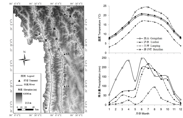
图1 研究区域内河流、地貌及植被调查的海拔样带位置图。N1: 片马; N2: 贡山; L1: 兰坪; L2: 维西; L3: 德钦; J1: 奔子栏。
Fig. 1 The geomorphology, rivers and the locations of altitudinal transects of vegetation survey in the study area. N1, Pianma; N2, Gongshan; L1, Lanping; L2, Weixi; L3, Deqin; J1, Benzilan.
| 河流 River | 样带 Transect | 样带地点 Location | 坡面 Aspect | 海拔范围 Elevation range (m) | 样方数 No. of plots | |
|---|---|---|---|---|---|---|
| 灌丛 Shrubs | 森林 Forest | |||||
| 怒江 Nu River | N1 | 片马 Pianma | 西坡 West | 900-2,100 | 2,200-3,100 | 39 |
| N2 | 贡山 Gongshan | 西坡 West | 1,100-1,900 | 2,000-2,900 | 27 | |
| 澜沧江 Lancang River | L1 | 兰坪 Lanping | 东坡 East | 1,700-2,400 | 2,500-3,100 | 32 |
| L2 | 维西 Weixi | 东坡 East | 2,000-2,300 | 2,400-2,800 | 28 | |
| L3 | 德钦 Deqin | 东坡 East | 2,000-2,600 | 2,700-3,200 | 34 | |
| 金沙江 Jinsha River | J1 | 奔子栏 Benzilan | 西坡 West | 2,000-2,700 | 2,800-3,200 | 32 |
表1 三江并流干旱河谷样方基本信息
Table 1 The features of six transects of vegetation survey in the Three Parallel River Region
| 河流 River | 样带 Transect | 样带地点 Location | 坡面 Aspect | 海拔范围 Elevation range (m) | 样方数 No. of plots | |
|---|---|---|---|---|---|---|
| 灌丛 Shrubs | 森林 Forest | |||||
| 怒江 Nu River | N1 | 片马 Pianma | 西坡 West | 900-2,100 | 2,200-3,100 | 39 |
| N2 | 贡山 Gongshan | 西坡 West | 1,100-1,900 | 2,000-2,900 | 27 | |
| 澜沧江 Lancang River | L1 | 兰坪 Lanping | 东坡 East | 1,700-2,400 | 2,500-3,100 | 32 |
| L2 | 维西 Weixi | 东坡 East | 2,000-2,300 | 2,400-2,800 | 28 | |
| L3 | 德钦 Deqin | 东坡 East | 2,000-2,600 | 2,700-3,200 | 34 | |
| 金沙江 Jinsha River | J1 | 奔子栏 Benzilan | 西坡 West | 2,000-2,700 | 2,800-3,200 | 32 |
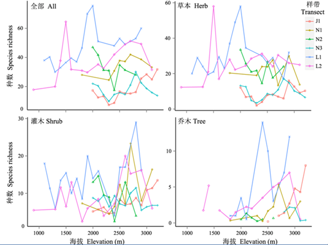
图2 三个流域6条植被样带中全部植物和不同生长型物种丰富度的海拔梯度分布。N1: 怒江片马; N2: 怒江贡山; L1: 澜沧江兰坪; L2: 澜沧江维西; L3: 澜沧江德钦; J1: 金沙江奔子栏。
Fig. 2 Elevational gradients of species richness of all plants and different growth-forms for the six vegetation transects in the three watersheds. N1, Nu River Pianma; N2, Nu River Gongshan; L1, Lancang River Lanping; L2, Lancang River Weixi; L3, Lancang River Deqin; J1, Jinsha River Benzilan.
| 环境因子 Environmental factors | 草本种 Herb species | 灌木种 Shrub species | 乔木种 Tree species | 全部种 Total species |
|---|---|---|---|---|
| 纬度 Latitude | 0.233*** | 0.332*** | 0.404*** | 0.286*** |
| 经度 Longitude | -0.561 | 1.417** | 0.775 | 0.227 |
| 海拔 Elevation | 3.11E-4*** | 4.01E-4** | 4.54E-4 | 3.71E-4*** |
| 坡向 余弦 Aspect cos | -0.124*** | 0.033 | 0.021 | -0.078** |
| 坡向 正弦 Aspect sin | -0.019 | 0.204*** | 0.562*** | 0.084** |
| 坡度 Slope | -2.851E-3# | 4.501E-3# | -4.989E-5 | -0.550E-3 |
| 澜沧江 Lancang River? | 0.308 | -0.685** | -2.046*** | -0.201 |
| 怒江 Nu River? | 1.783*** | 1.190*** | 0.622 | 1.554*** |
| 森林段 Forest section? | -0.221* | 0.061 | 1.074*** | -0.062 |
| Adj.-R2 | 0.671 | 0.341 | 0.407 | 0.713 |
表2 植物群落样带物种丰富度格局GLM模型的回归系数及其统计显著性(? 代表类别变量, 对应的系数代表类别变量不同水平与模型缺省水平, 即截距的差异值, 这对应的河流是金沙江, 对应的植被带是灌草丛带。统计检验的显著性: ***P<0.001; ** P<0.01; * P<0.05; # 0.05< P<0.1)。
Table 2 The coefficients and corresponding statistic significance of the generalized linear models for species richness patterns of the plant communities transects. ? refers to categorical variable, the corresponding coefficient equals to the intercept difference between the referring level and the default level, which is the Jinsha River when considering the variable “river”, and the Shrub & Herb section when considering the variable “vegetation type”.
| 环境因子 Environmental factors | 草本种 Herb species | 灌木种 Shrub species | 乔木种 Tree species | 全部种 Total species |
|---|---|---|---|---|
| 纬度 Latitude | 0.233*** | 0.332*** | 0.404*** | 0.286*** |
| 经度 Longitude | -0.561 | 1.417** | 0.775 | 0.227 |
| 海拔 Elevation | 3.11E-4*** | 4.01E-4** | 4.54E-4 | 3.71E-4*** |
| 坡向 余弦 Aspect cos | -0.124*** | 0.033 | 0.021 | -0.078** |
| 坡向 正弦 Aspect sin | -0.019 | 0.204*** | 0.562*** | 0.084** |
| 坡度 Slope | -2.851E-3# | 4.501E-3# | -4.989E-5 | -0.550E-3 |
| 澜沧江 Lancang River? | 0.308 | -0.685** | -2.046*** | -0.201 |
| 怒江 Nu River? | 1.783*** | 1.190*** | 0.622 | 1.554*** |
| 森林段 Forest section? | -0.221* | 0.061 | 1.074*** | -0.062 |
| Adj.-R2 | 0.671 | 0.341 | 0.407 | 0.713 |
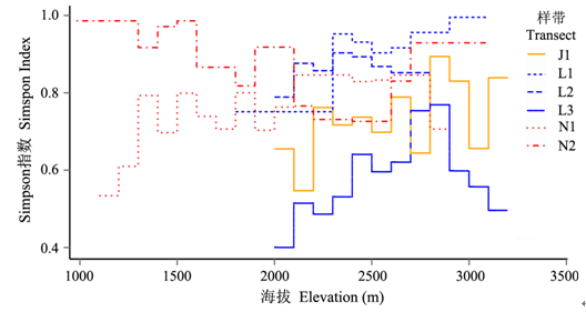
图3 不同样带植被沿海拔梯度的物种更替率(以Simpson指数表示)
Fig. 3 The species turnover rate (Simpson index) of plant community along the elevational transects of vegetation
| 1 | Alicia MY, Moreno LA, Piñero D, Jorgensen TH, Emerson BC (2015) Biodiversity in the mexican highlands and the interaction of geology, geography and climate within the trans-mexican volcanic belt. Journal of Biogeography, 42, 1586-1600. |
| 2 | Barthlott W, Hostert A, Kier G, Kueper W, Kreft H, Mutke J (2007) Geographic patterns of vascular plant diversity at continental to global scales. Erdkunde, 61, 305-315. |
| 3 | Baselga A (2010) Partitioning the turnover and nestedness components of beta diversity. Archives Danatomie Dhistologie Et Dembryologie Normales Et Expérimentales, 19, 134-143. |
| 4 | Baselga A, Leprieur F (2015) Comparing methods to separate components of beta diversity. Methods in Ecology and Evolution, 6, 1069-1079. |
| 5 | Beck J, Chey VK (2008) Explaining the elevational diversity pattern of geometrid moths from borneo: a test of five hypotheses. Journal of Biogeography, 35, 1452-1464. |
| 6 | Beck J, Kitching IJ (2009) Drivers of moth species richness on tropical altitudinal gradients: a cross-regional comparison. Global Ecology & Biogeography, 18, 361-371. |
| 7 | Bram V, Falko B, Luc B (2013) Disturbance regime alters the impact of dispersal on alpha and beta diversity in a natural metacommunity. Ecology, 11, 2547-2557. |
| 8 | Colwell RK, Rahbek C, Gotelli N (2004) The mid-domain effect and species richness patterns: what have we learned so far? The American Naturalist, 163, E1-E23. |
| 9 | Donzelli D, DeMichele C, Scholes RJ (2013) Competition between trees and grasses for both soil water and mineral nitrogen in dry savannas. Journal of Theoretical Biology, 332, 181-190. |
| 10 | Fang JY (2004) Exploring altitudinal patterns of plant diversity of China’s mountains. Biodiversity Science, 12, 1-4.(in Chinese) |
| [方精云 (2004) 探索中国山地植物多样性的分布规律. 生物多样性, 12, 1-4.] | |
| 11 | Feng JM, Wang XP, Xu CD, Yang YH, Fang JY (2006) Altitudinal patterns of plant species diversity and community structure on Yulong Mountains, Yunnan, China. Journal of Mountain Science, 24, 110-116.(in Chinese with English abstract) |
| [冯建孟, 王襄平, 徐成东, 杨元合, 方精云 (2006) 玉龙雪山植物物种多样性和群落结构沿海拔梯度的分布格局. 山地学报, 24, 110-116.] | |
| 12 | Graham CH, Fine PVA (2008) Phylogenetic beta diversity: linking ecological and evolutionary processes across space in time. Ecology Letters, 11, 1265-1277. |
| 13 | Grytnes JA (2003) Species-richness patterns of vascular plants along seven altitudinal transects in Norway. Ecography, 26, 291-300. |
| 14 | Grytnes JA, Heegaard E, Romdal TS (2008) Can the mass effect explain the mid-altitudinal peak in vascular plant species richness? Basic and Applied Ecology, 9, 373-382. |
| 15 | He JS, Chen WL (1997) A review of gradient changes in spec ies diversity of land plant communities. Acta ecologica sinica, 17, 91-99.(in Chinese with English abstract) |
| [贺金生, 陈伟烈 (1997) 陆地植物群落物种多样性的梯度变化特征. 生态学报, 17, 91-99.] | |
| 16 | He YB, Lu PZ, Zhu T (2000) Causes for the formation of dry-hot valleys in Hengduan Mountain, Yunnan Plateau. Resources Science, 22(5), 69-72.(in Chinese with English abstract) |
| [何永彬, 卢培泽, 朱彤 (2000) 横断山——云南高原干热河谷形成原因研究. 资源科学, 22(5), 69-72.] | |
| 17 | Hubbell SP (1979) Tree dispersion, abundance, and diversity in a tropical dry forest. Science, 203, 1299-1309. |
| 18 | Jiang LG, Liu XN, Feng ZM (2014) Spatial-temporal pattern analysis of land use and land cover change in Xishuangbanna. Resources Science, 36(2), 259-266.(in Chinese with English abstract) |
| [姜鲁光, 刘晓娜, 封志明 (2014) 西双版纳土地利用/土地覆被变化时空格局分析. 资源科学, 36(2), 259-266.] | |
| 19 | Jiang Y, Kang MY, Zhu Y, Xu GC (2007) Plant biodiversity patterns on Helan Mountain, China. Acta Oecologica, 32, 125-133. |
| 20 | Kessler M (2000) Altitudinal zonation of andean cryptogam communities. Journal of Biogeography, 27, 275-282. |
| 21 | Kraaij T, Ward D (2006) Effects of rain, nitrogen, fire and grazing on tree recruitment and early survival in bush-encroached savanna, South Africa. Plant Ecology, 186, 235-246. |
| 22 | Li K, Liu FY, Yang ZY, Sun YY (2011) Study status and trends of vegetation restoration of dry-hot valley in Southwest China. World Forestry Research, 24(4), 55-60.(in Chinese with English abstract) |
| [李昆, 刘方炎, 杨振寅, 孙永玉 (2011) 中国西南干热河谷植被恢复研究现状与发展趋势. 世界林业研究, 24(4), 55-60.] | |
| 23 | Li XW (1995) A floristic study on the seed plants from the region of Yunnan Plateau. Acta Botanica Yunnanica, 17(1), 1-14. |
| (in Chinese with English abstract) [李锡文 (1995) 云南高原地区种子植物区系. 云南植物研究, 17(1), 1-14.] | |
| 24 | Liu FY, Li K, Sun YY, Tang GY, Zhang CH (2010) Effects of climate on vegetation recovery in dry-hot valleys of Heng- duan Mountainous region in Southwest China. Resources and Environment in the Yangtze Basin, 19, 1386-1391.(in Chinese with English abstract) |
| [刘方炎, 李昆, 孙永玉, 唐国勇, 张春华 (2010) 横断山区干热河谷气候及其对植被恢复的影响.长江流域资源与环境, 19, 1386-1391.] | |
| 25 | MacArthur RH (1972) Mathematical ecology and its place among the sciences. Science, 178, 389-394. |
| 26 | Ma K, Li YN, Jin H, Long ZH, Lu YP (2011) A comparison of the species diversity of Trollius chinensis community in different habitats. Pratacultural Science, 28, 1467-1472.(in Chinese with English abstract) |
| [马凯, 李永宁, 金辉, 龙在海, 卢银平 (2011) 不同生境类型金莲花群落物种多样性比较. 草业科学, 28, 1467-1472.] | |
| 27 | McCain CM, Sanders NJ (2010) Metabolic theory and elevational diversity of vertebrate ectotherms. Ecology, 91, 601-609. |
| 28 | Ming QZ, Shi ZT (2007) New discussion on dry valley formation in the Three Parallel Rivers Region. Journal of Desert Research, 27(1), 99-104.(in Chinese with English abstract) |
| [明庆忠, 史正涛 (2007) 三江并流区干热河谷成因新探析. 中国沙漠, 27, 99-104.] | |
| 29 | Myers N, Mittermeier RA, Mittermeier CG, Da FG, Kent J (2000) Biodiversity hotspots for conservation priorities. Nature, 403, 853-858. |
| 30 | Nong Y, Zheng L, Jia HY, Lu LH, Huang DW, Huang BH, Lei LQ (2015) Community characteristics and spatial distribution of dominant tree species in a secondary forest of Daqing Mountains, southwestern Guangxi, China. Biodiversity Science, 23, 321-331.(in Chinese with English abstract) |
| [农友, 郑璐, 贾宏炎, 卢立华, 黄德卫, 黄柏华, 雷丽群 (2015) 广西大青山次生林的群落特征及主要乔木种群的空间分布格局. 生物多样性, 23, 321-331.] | |
| 31 | Novillo A, Ojeda RA (2014) Elevation patterns in rodent diversity in the dry Andes: disentangling the role of environmental factors. Journal of Mammalogy, 95, 99-107. |
| 32 | O’Brien EM, Field R, Whittaker RJ (2000) Climatic gradients in woody plant (tree and shrub) diversity: water-energy dynamics, residual variation, and topography. Oikos, 89, 588-600. |
| 33 | Ou XK, Jin ZZ (1996) A preliminary study on the flora and ecological diversity in Jinsha River dry-hot Valley. Journal of Wuhan Botanical Research, 14, 318-322.(in Chinese with English abstract) |
| [欧晓昆, 金振洲 (1996) 金沙江干热河谷植物区系和生态多样性的初步研究. 武汉植物研究, 14, 318-322.] | |
| 34 | Peixoto FP, Braga PHP, Cianciaruso MV, Diniz-Filho JAF, Brito D (2014) Global patterns of phylogenetic beta diversity components in bats. Journal of Biogeography, 41, 762-772. |
| 35 | Qian H, Badgley C, Fox DL (2009) The latitudinal gradient of beta diversity in relation to climate and topography for mammals in North America. Global Ecology and Biogeography, 18, 111-122. |
| 36 | Rahbek, C. (2005). The role of spatial scale and the perception of large-scale species-richness patterns. Ecology Letters, 8, 224-239. |
| 37 | Rossatto DR, Hoffmann WA, Franco AC (2009) Differences in growth patterns between co-occurring forest and savanna trees affect the forest-savanna boundary. Functional Ecology, 23, 689-698. |
| 38 | Ruifrok JL, Postma F, Olff H, Smit C (2014) Scale-dependent effects of grazing and topographic heterogeneity on plant species richness in a Dutch salt marsh ecosystem. Applied Vegetation Science, 17, 615-624. |
| 39 | Salazar A, Goldstein G, Franco AC (2012) Differential seedling establishment of woody plants along a tree density gradient in Neotropical savannas. Journal of Ecology, 100, 1411-1421. |
| 40 | Sankaran M, Ratnam J, Hanan N (2008) Woody cover in African savannas: the role of resources, fire and herbivory. Global Ecology and Biogeography, 17, 236-245. |
| 41 | Shen R, Zhang JL, He B, Li F, Zhang ZM, Zhou R, Ou XK (2010) The structure characteristic and analysis on similarity of grassland community in dry-hot valley of Yuanjiang River. Ecology and Environmental Sciences, 19, 2821-2825.(in Chinese with English abstract) |
| [沈蕊, 张建利, 何彪, 李峰, 张志明, 周睿, 欧晓昆 (2010) 元江流域干热河谷草地植物群落结构特征与相似性分析. 生态环境学报, 19, 2821-2825.] | |
| 42 | Shen ZH, Hu HF, Zhou Y, Fang JY (2004) Altitudinal patterns of plant species diversity on the southern slope of Mt. Shennongjia, Hubei, China. Biodiversity Science, 12, 99-107.(in Chinese with English abstract) |
| [沈泽昊, 胡会峰, 周宇, 方精云 (2004) 神农架南坡植物群落多样性的海拔梯度格局. 生物多样性, 12, 99-107.] | |
| 43 | Shen ZH, Zhang XS (2000) A quantitative analysis on the floristic elements of the Chinese subtropical region and their spatial patterns. Acta phytotaxonomica Sinica, 38, 366-380. |
| [沈泽昊, 张新时(2000)中国亚热带地区植物区系地理成分及其空间格局的数量分析. 植物分类学报, 38, 366-380.] | |
| 44 | Slik JWF, Raes N, Aiba SI, Brearley FQ, Cannon CH (2009) Environmental correlates for tropical tree diversity and distribution patterns in Borneo. Diversity and Distributions, 19, 523-532. |
| 45 | Stevens G (1996) Extending rapoport's rule to pacific marine fishes. Journal of Biogeography, 23, 149-154. |
| 46 | Sun ZH, Peng SJ, Ou XK (2007) A quick assessment and environmental interpretation for the tree species richness in the Gaoligong Mountain Range. Chinese Science Bulletin, 52(S2), 195-200. |
| [孙振华, 彭声静, 欧晓昆 (2007) 高黎贡山乔木树种丰富度快速评估及其环境解释. 科学通报, 52(S2), 195-200.] | |
| 47 | Svenning JC, Fitzpatrick MC, Normand S, Graham CH, Pear- man PB, Iverson LR, Skov F (2010) Geography, topogra- phy, and history affect realized-to-potential tree species richness patterns in Europe. Ecography, 33, 1070-1080. |
| 48 | Tao J, Zang RG, Yu CY (2011) Altitudinal patterns of plant communities and species diversity in the Habaxueshan Mountains, Yunnan, China. Scientia Silvae Sinicae, 47(7), 1-6.(in Chinese with English abstract) |
| [陶晶, 臧润国, 余昌元 (2011) 云南哈巴雪山植物群落和植物多样性海拔梯度分布格局. 林业科学, 47(7), 1-6.] | |
| 49 | Tang ZY, Fang JY (2004) A review on the elevational patterns of plant species diversity. Biodiversity Sciences, 2004, 12, 20-28.(in Chinese with English abstract) |
| [唐志尧, 方精云 (2004) 植物物种多样性的垂直分布格局. 生物多样性, 12, 20-28.] | |
| 50 | Valdés A, Lenoir J, Emilie GM, Andrieu E, Brunet J, Chabrerie O, Déborah CK, Cousins SA, Deconchat M, Frenne PD, Smedt PD, Diekmann M, Hansen K, Hermy M, Kolb A, Liira J, Lindgren J, Naaf T, Paal T, Prokofieva I, Michael SL, Wulf M, Verheyen K, Decocq G (2015) The contribution of patch-scale conditions is greater than that of macroclimate in explaining local plant diversity in fragmented forests across Europe. Global Ecology and Biogeography, 24, 1094-1105. |
| 51 | Vega RV, Salazar A, Wilhelm FM (2014) Do groundwater dynamics drive spatial patterns of tree density and diversity in Neotropical savannas. Journal of Vegetation Science, 25, 1465-1473. |
| 52 | Wang KQ, Shen YX, Chen QB, Wang ZH (2004) Soil water environment of artificial vegetation in Jinshajiang dry-hot valley. Chinese Journal of Applied Ecology, 15, 809-813.(in Chinese with English abstract) |
| [王克勤, 沈有信, 陈奇伯, 王震洪 (2004) 金沙江干热河谷人工植被土壤水环境. 应用生态学报, 15, 809-813.] | |
| 53 | Wang ZH, Chen AP, Piao SL, Fang JY (2004) Pattern of species richness along an altitudinal gradient on Gaoligong Mountains, Southwest China. Biodiversity Science, 12, 82-88.(in Chinese with English abstract) |
| [王志恒, 陈安平, 朴世龙, 方精云 (2004) 高黎贡山种子植物物种丰富度沿海拔梯度的变化. 生物多样性, 12, 82-88.] | |
| 54 | Wang ZH, Tang ZY, Fang JY (2007) Altitudinal patterns of seed plant richness in the Gaoligong Mountains, southeast Tibet, China. Diversity and Distributions, 13, 845-854. |
| 55 | Whittaker RH (1960) Vegetation of the Siskiyou Mountains, Oregon and California. Ecological Monographs, 30, 279-338. |
| 56 | Wu SH, Zhang YP (2009) The Special Environmental Patterns and Ecological Impacts in the Longitudinal Range-Gorge Region. Science Press, Beijing.(in Chinese with English abstract) |
| [吴绍洪, 张一平 (2009) 纵向岭谷区特殊环境格局与生态效应. 科学出版社, 北京.] | |
| 57 | Wu Y, Colwell RK, Han N, Zhang R, Wang W, Quan Q, Zhang C, Song G, Qu Y, Lei F (2014) Understanding historical and current patterns of species richness of babblers along a 5000 m subtropical elevational gradient. Global Ecology and Biogeography, 23, 1167-1176. |
| 58 | Xu J, Zhang BP, Zhu YH, Sun RH (2006) Distribution and geographical analysis of altitudinal belts in the Altun-Qilian Mountains. Geographical Research, 25, 977-984.(in Chinese with English abstract) |
| [许娟, 张百平, 朱运海, 孙然好 (2006) 阿尔金山-祁连山山地植被垂直带谱分布及地学分析. 地理研究, 25, 977-984.] | |
| 59 | Yang D, Xiong DH, Zhai J, Li JJ, Su ZA, Dong YF (2012) Morphological characteristics and causes of gullies in Yuanmou dry-hot valley region. Science of Soil and Water Conservation, 10, 38-45.(in Chinese with English abstract) |
| [杨丹, 熊东红, 翟娟, 李佳佳, 苏正安, 董一帆 (2012) 元谋干热河谷冲沟形态特征及其成因. 中国水土保持科学, 10, 38-45.] | |
| 60 | Yang R, Zhang BR, Wang LL, Yang JJ, Su WH, Zhang GF, Yang B, Zhou R (2010) The response of plant functional traits’ group to gradients of altitude in dry-hot valley of Yuan-Mou. Ecology and Environmental Sciences, 24, 49-56.(in Chinese with English abstract) |
| [杨锐, 张博睿, 王玲玲, 杨建军, 苏文华, 张光飞, 杨波, 周睿 (2010) 元谋干热河谷植物功能性状组合的海拔梯度响应. 生态环境学报, 24, 49-56.] | |
| 61 | Yang Y, Shen Z, Han J, Zhongyong C (2016) Elevational gradients of plant species diversity along east and west slopes of Baima Snow Mountain in Southwest China. Forests, 7, 89-105. |
| 62 | Zhang JL, Liu XK, Shen R, Shi W, Zhang ZM, Zhou R, Ou XK (2010) The species quantitative & diversity characteristic of grassland community in hot-dry valley of Jinsha River. Ecology and Environmental Sciences, 19, 1519-1524.(in Chinese with English abstract) |
| [张建利, 柳小康, 沈蕊, 施雯, 张志明, 周睿, 欧晓昆 (2010) 金沙江流域干热河谷草地群落物种数量及多样性特征. 生态环境学报, 19, 1519-1524.] | |
| 63 | Zhang YP, Duan ZX, Dou JX (2005) Comparison of climate characteristics between a dry-warm valley in upper reaches of Min River and a dry-hot valley of Yuanjiang River. Resources and Environment in the Yangtze Basin, 14(1), 76-82.(in Chinese with English abstract) |
| [张一平, 段泽新, 窦军霞 (2005) 岷江上游干暖河谷与元江干热河谷的气候特征比较研究. 长江流域资源与环境, 14(1), 76-82.] | |
| 64 | Zhang ZM, Wang WL, Ou XK, Wu WQ (2009) The correlation between vegetation spatial pattern and environmental factors. Journal of Yunnan University (Natural Sciences Edition), 31, 311-315.(in Chinese with English abstract) |
| [张志明, 王文礼, 欧晓昆, 吴伟强 (2009) 梅里雪山植被空间格局与环境因子关系分析 . 云南大学学报(自然科学版),31, 311-315.] | |
| 65 | Zhao L, Lang NJ, Zheng K, Peng MJ (2006) A study on eco-environmental characteristics of dry and hot valley of Yunnan Province. Forest Inventory and Planning, 31(3), 114-117.(in Chinese with English abstract) |
| [赵琳, 郎南军, 郑科, 彭明俊 (2006) 云南干热河谷生态环境特性研究 . 林业调查规划,31(3), 114-117.] |
| [1] | 吴晓晴 张美惠 葛苏婷 李漫淑 宋坤 沈国春 达良俊 张健. 上海近自然林重建过程中木本植物物种多样性与地上生物量的时空动态——以闵行区生态岛为例[J]. 生物多样性, 2025, 33(5): 24444-. |
| [2] | 王太, 宋福俊, 张永胜, 娄忠玉, 张艳萍, 杜岩岩. 河西走廊内陆河水系鱼类多样性及资源现状[J]. 生物多样性, 2025, 33(4): 24387-. |
| [3] | 张晶晶, 黄文彬, 陈奕廷, 杨泽鹏, 柯伟业, 彭昭杰, 魏世超, 张志伟, 胡怡思, 余文华, 周文良. 广东南澎列岛海洋生态国家级自然保护区造礁石珊瑚多样性及分布特征[J]. 生物多样性, 2025, 33(4): 24424-. |
| [4] | 张明燡, 王晓梅, 郑言鑫, 吴楠, 李东浩, 樊恩源, 李娜, 单秀娟, 于涛, 赵春暖, 李波, 徐帅, 吴玉萍, 任利群. 黄河口典型牡蛎礁分布区资源状况和栖息地功能[J]. 生物多样性, 2025, 33(4): 24208-. |
| [5] | 仝淼, 王欢, 张文双, 王超, 宋建潇. 重金属污染土壤中细菌抗生素抗性基因分布特征[J]. 生物多样性, 2025, 33(3): 24101-. |
| [6] | 尚华丹, 张楚晴, 王梅, 裴文娅, 李国宏, 王鸿斌. 中国杨树害虫物种多样性及其地理分布[J]. 生物多样性, 2025, 33(2): 24370-. |
| [7] | 吴昱萱, 王平, 胡晓生, 丁一, 彭甜恬, 植秋滢, 巴德木其其格, 李文杰, 关潇, 李俊生. 呼伦贝尔草地退化现状评估与植被特征变化[J]. 生物多样性, 2025, 33(2): 24118-. |
| [8] | 李艳朋, 陈洁, 卢春洋, 许涵. 海南尖峰岭热带山地雨林64 ha次生林动态监测样地群落结构特征[J]. 生物多样性, 2025, 33(2): 24445-. |
| [9] | 陈自宏, 张翼飞, 陈凯, 陈见影, 徐玲. 高黎贡山南段昆虫病原真菌物种多样性及影响因素[J]. 生物多样性, 2025, 33(1): 24228-. |
| [10] | 谭珂, 宁瑶, 王仁芬, 王晴, 梁丹萍, 辛子兵, 温放. 中国苦苣苔科植物名录与地理分布数据集[J]. 生物多样性, 2025, 33(1): 23275-. |
| [11] | 韩佳楠, 苏杨, 李霏, 刘君妍, 赵依林, 李琳, 赵建成, 梁红柱, 李敏. 河北省苔藓植物多样性[J]. 生物多样性, 2024, 32(9): 24096-. |
| [12] | 魏诗雨, 宋天骄, 罗佳宜, 张燕, 赵子萱, 茹靖雯, 易华, 林雁冰. 秦岭火地塘针叶林土壤细菌群落的海拔分布格局[J]. 生物多样性, 2024, 32(9): 24180-. |
| [13] | 李东红, 郝媛媛, 甘辉林, 张航, 刘耀猛, 他富源, 胡桂馨. 祁连山北麓中段不同类型草地蝗虫种类及分布[J]. 生物多样性, 2024, 32(9): 24119-. |
| [14] | 李蓉姣, 董江海, 郑文芳, 刘入源, 赵立娟, 高瑞贺. 关帝山不同海拔杨桦混交林土壤动物多样性特征及其影响因素[J]. 生物多样性, 2024, 32(9): 24070-. |
| [15] | 牛红玉, 陈璐, 赵恒月, 古丽扎尔·阿不都克力木, 张洪茂. 城市化对动物的影响: 从群落到个体[J]. 生物多样性, 2024, 32(8): 23489-. |
| 阅读次数 | ||||||
|
全文 |
|
|||||
|
摘要 |
|
|||||
备案号:京ICP备16067583号-7
Copyright © 2026 版权所有 《生物多样性》编辑部
地址: 北京香山南辛村20号, 邮编:100093
电话: 010-62836137, 62836665 E-mail: biodiversity@ibcas.ac.cn
![]()