
Biodiv Sci ›› 2025, Vol. 33 ›› Issue (4): 24236. DOI: 10.17520/biods.2024236 cstr: 32101.14.biods.2024236
• Technology and Methodology • Previous Articles Next Articles
Xie Gan1,2,#, Xuan Jing1,2,#, Fu Qidi1,#, Wei Ze1, Xue Kai1, Luo Hairui1, Gao Jixi3,*( ), Li Min1,2,*()
Received:2024-06-14
Accepted:2024-10-15
Online:2025-04-20
Published:2025-01-03
Contact:
*E-mail: gjx@nies.org;
iplant@ibcas.ac.cn
About author:#Co-first authors
Supported by:Xie Gan, Xuan Jing, Fu Qidi, Wei Ze, Xue Kai, Luo Hairui, Gao Jixi, Li Min. Establishing an intelligent identification model for unmanned aerial vehicle surveys of grassland plant diversity[J]. Biodiv Sci, 2025, 33(4): 24236.
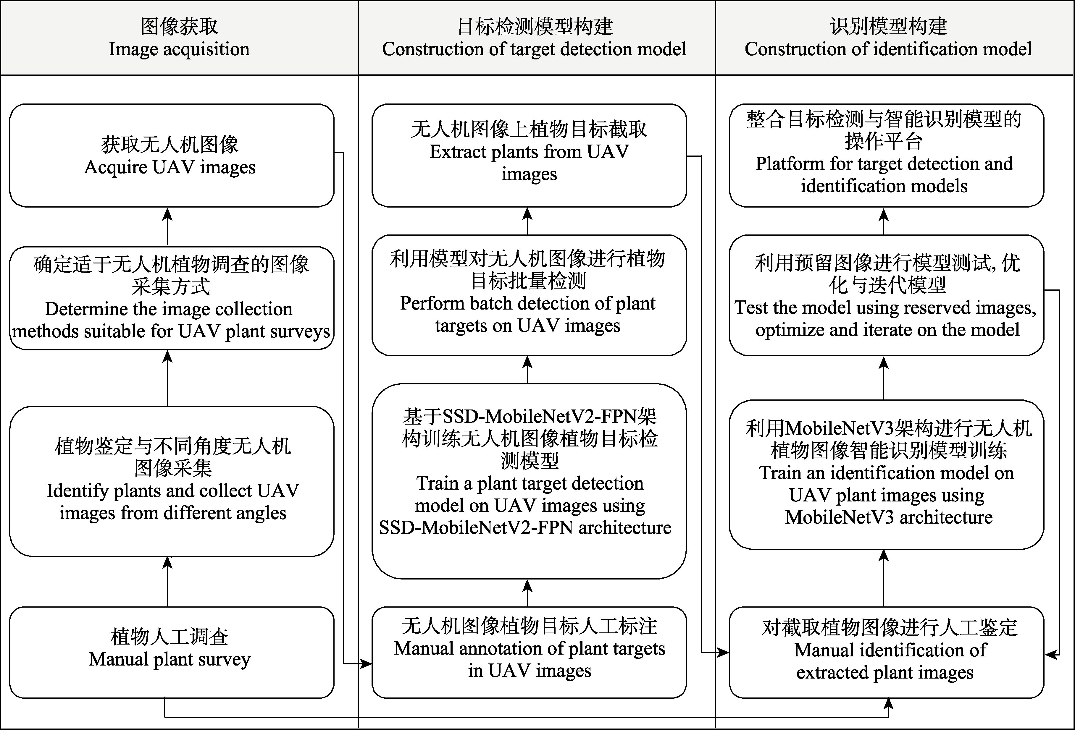
Fig. 1 Process for intelligent identification of grassland plant images captured by unmanned aerial vehicle (UAV)
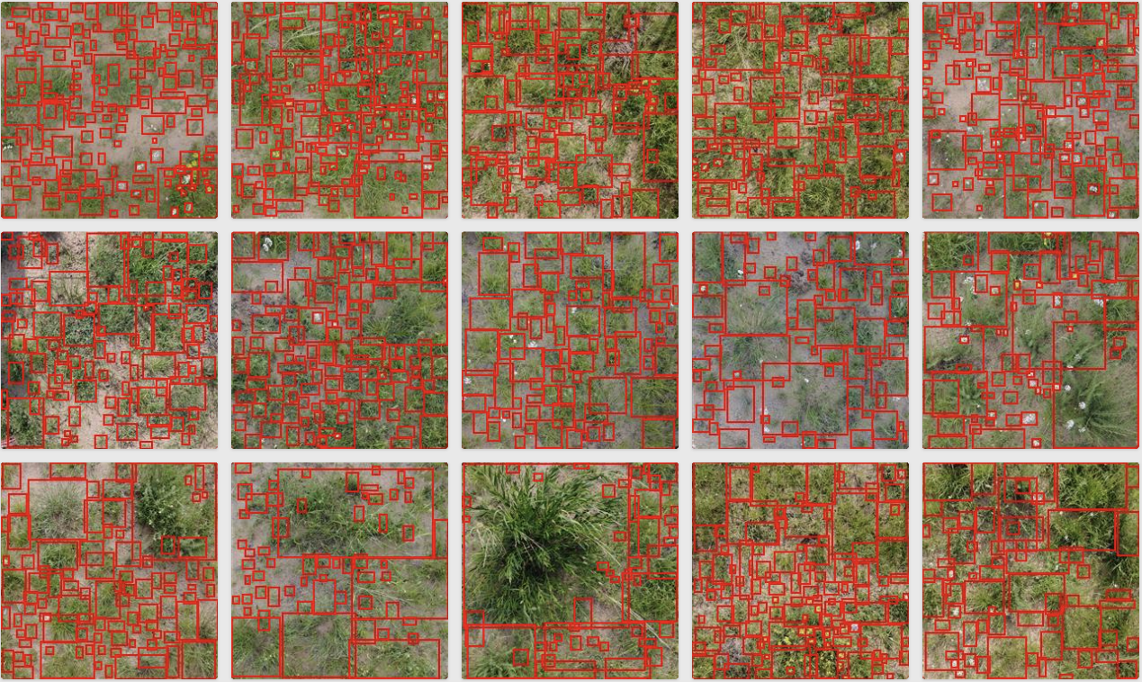
Fig. 2 Manual labeling for target detection in images captured by unmanned aerial vehicle (UAV)
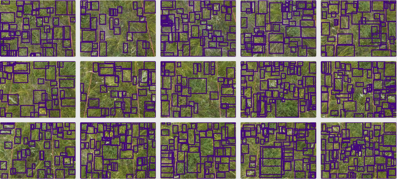
Fig. 3 Intelligent frame selection of target detection model for taking line transect photos
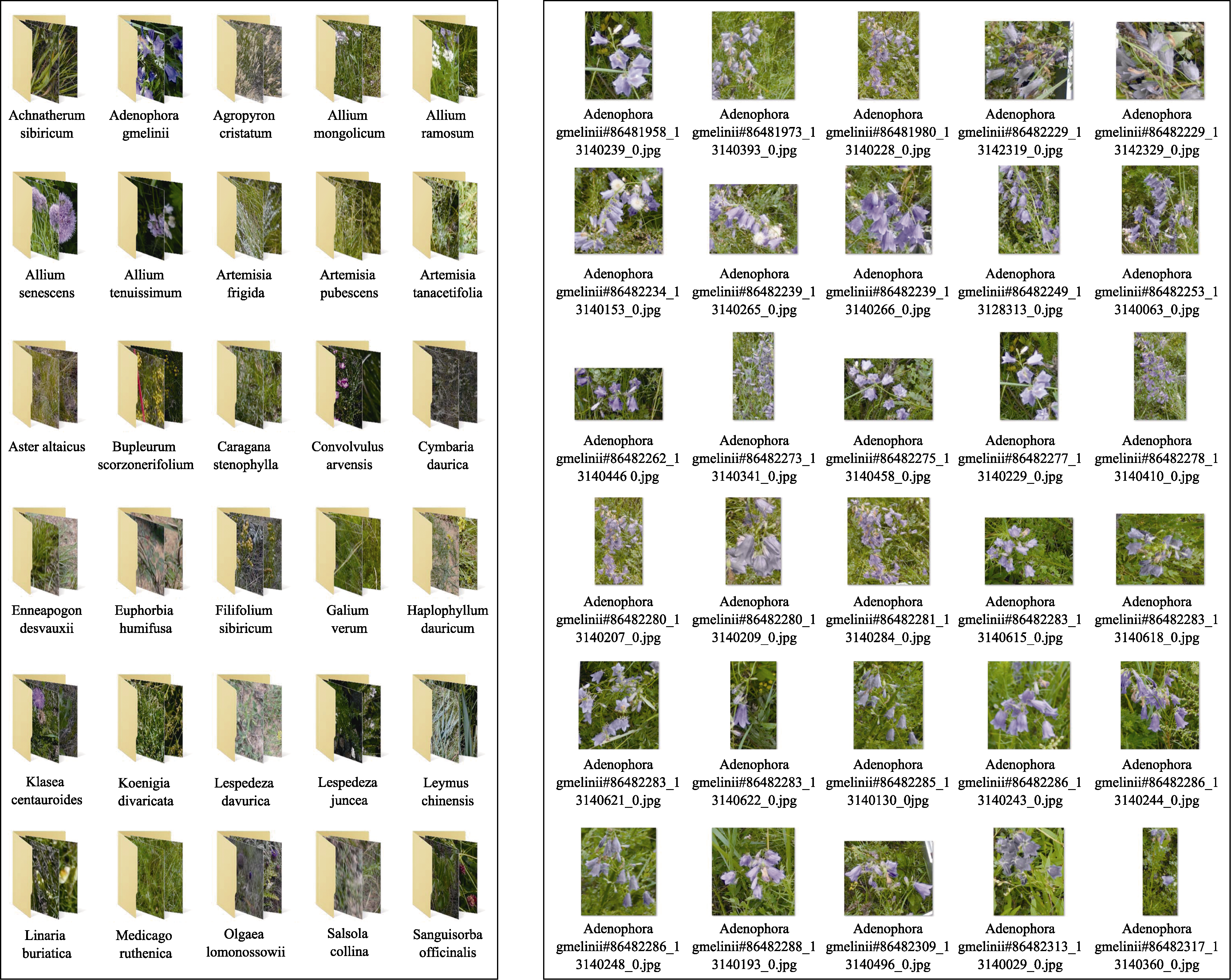
Fig. 4 Image dataset for establishing identification models (Left, Dataset of species; Right, Images of species)
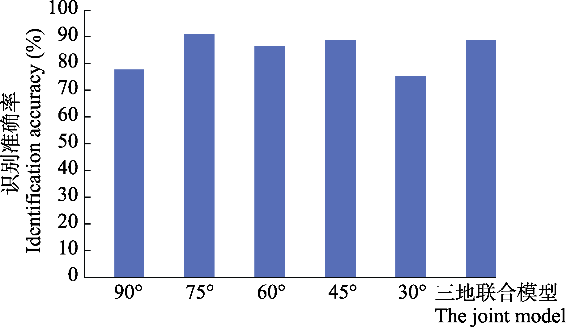
Fig. 5 Identification accuracy of intelligent models for plant images taken by unmanned aerial vehicle (UAV)
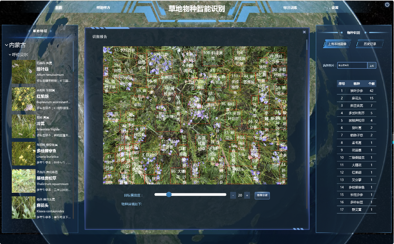
Fig. 6 Platform of Intelligent Species Identification System Website for investigation of grassland plant diversity by unmanned aerial vehicle (UAV) (http://www.iplant.cn/tc)
| [1] | Cao JJ, Leng WC, Liu K, Liu L, He Z, Zhu YH (2018) Object-based mangrove species classification using unmanned aerial vehicle hyperspectral images and digital surface models. Remote Sensing, 10, 89. |
| [2] | Chiu YC, Tsai CY, Ruan MD, Shen GY, Lee TT (2020) Mobilenet-SSDv2:An improved object detection model for embedded systems. In: 2020 International Conference on System Science and Engineering, pp. 1-5. Kagawa, Japan. |
| [3] | Du C, Liu J, Liu S, Ma JS (2022) A current and historical situation report of Chinese plant taxonomists. Biodiversity Science, 30, 22355. (in Chinese with English abstract) |
|
[杜诚, 刘军, 刘夙, 马金双 (2022) 中国植物分类学者的历史与现状. 生物多样性, 30, 22355.]
DOI |
|
| [4] | Emin M, Anwar E, Liu SH, Emin B, Mamut M, Abdukeram A, Liu T (2021) Target detection-based tree recognition in a spruce forest area with a high tree density—Implications for estimating tree numbers. Sustainability, 13, 3279. |
| [5] | Hong QQ, Zhong XY, Chen WT, Zhang ZH, Li B (2023) Hyperspectral image classification network based on 3D octave convolution and multiscale depthwise separable convolution. ISPRS International Journal of Geo-Information, 12, 505. |
| [6] | Husson E, Hagner O, Ecke F (2014) Unmanned aircraft systems help to map aquatic vegetation. Applied Vegetation Science, 17, 567-577. |
| [7] | LeCun Y, Bengio Y, Hinton G (2015) Deep learning. Nature, 521, 436-444. |
| [8] | Leduc MB, Knudby AJ (2018) Mapping wild leek through the forest canopy using a UAV. Remote Sensing, 10, 70. |
| [9] | Li AL, Dai ZG, Chen JQ, Deng CH, Tang Q, Cheng CH, Xu Y, Zhang XY, Su JG, Yang ZM (2023) Progresses of machine learning application in plant phenotype research. Plant Fiber Sciences in China, 45(5), 248-253, 260. (in Chinese with English abstract) |
| [李阿蕾, 戴志刚, 陈基权, 邓灿辉, 唐蜻, 程超华, 许英, 张小雨, 粟建光, 杨泽茂 (2023) 机器学习在植物表型中的应用进展. 中国麻业科学, 45(5), 248-253, 260.] | |
| [10] | Lin TY, Dollár P, Girshick R, He KM, Hariharan B, Belongie S (2017) Feature pyramid networks for object detection. In:Proceedings of the IEEE Conference on Computer Vision and Pattern Recognition, pp. 2117-2125. Honolulu, HI, USA. |
| [11] | Liu W, Anguelov D, Erhan D, Szegedy C, Reed S, Fu CY, Berg AC (2016) SSD:Single shot multibox detector. In:Computer Vision—ECCV 2016: 14th European Conference, pp. 21-37. Amsterdam, The Netherlands. |
| [12] | Liu ZL, Wang J, Tian Y, Dai SL (2019) Deep learning for image-based large-flowered Chrysanthemum cultivar recognition. Plant Methods, 15, 146. |
| [13] | Lü LY, Zhao Y, Yu GQ (2016) History, current situation and trends of the investigation for grassland plant resources at home and abroad. Heilongjiang Animal Science and Veterinary Medicine, (19), 140-143, 150. (in Chinese with English abstract) |
| [吕林有, 赵艳, 于国庆 (2016) 国内外草地植物资源调查历史现状与趋势. 黑龙江畜牧兽医, (19), 140-143, 150.] | |
| [14] | Peng Y, Tao ZY, Xu ZY, Bai L (2020) Detection of plant species beta-diversity in Hunshandak Sandy grasslands using hyperspectral data. Spectroscopy and Spectral Analysis, 40, 2016-2022. (in Chinese with English abstract) |
| [彭羽, 陶子叶, 许子妍, 白岚 (2020) 应用高光谱数据估算植物物种beta多样性. 光谱学与光谱分析, 40, 2016-2022.] | |
| [15] | Shang SB, Fan L, Liu N, Zhang FQ (2024) Flora of seed plants in Qinghai Area of the Kunlun Mountain National Park. Acta Botanica Boreali-Occidentalia Sinica, 44, 491-501. (in Chinese with English abstract) |
| [尚帅斌, 范琳, 刘楠, 张发起 (2024) 昆仑山国家公园青海片区评估区种子植物区系研究. 西北植物学报, 44, 491-501.] | |
| [16] | Sun Y, Liu Y, Wang G, Zhang HY (2017) Deep learning for plant identification in natural environment. Computational Intelligence and Neuroscience, 2017, 7361042. |
| [17] | Sun Y, Yuan YX, Luo YF, Ji WX, Bian QY, Zhu ZQ, Wang JR, Qin Y, He XZ, Li M, Yi SH (2022) An improved method for monitoring multiscale plant species diversity of alpine grassland using UAV: A case study in the source region of the Yellow River, China. Frontiers in Plant Science, 13, 905715. |
| [18] |
Sun ZY, Wang XN, Wang ZH, Yang L, Xie YC, Huang YH (2021) UAVs as remote sensing platforms in plant ecology: Review of applications and challenges. Journal of Plant Ecology, 14, 1003-1023.
DOI |
| [19] | Szegedy C, Loffe S, Vanhoucke V, Alemi A (2016a) Inception-v4, inception-ResNet and the impact of residual connections on learning. In: AAAI’17: Proceedings of the Thirty-First AAAI Conference on Artificial Intelligence (eds Singh S, Markovitch S), pp. 4278-4284. AAAI Press, San Francisco, USA. |
| [20] | Szegedy C, Vanhoucke V, Ioffe S, Shlens J, Wojna Z (2016b) Rethinking the inception architecture for computer vision. In: Conference on Computer Vision and Pattern Recognition, pp. 2818-2826. Las Vegas, NV, USA. |
| [21] | Wan FM, Wan HW, Zhang ZR, Gao JX, Sun CX, Wang YC (2024) The application potential of unmanned aerial vehicle surveys in grassland plant diversity. Biodiversity Science, 32, 23381. (in Chinese with English abstract) |
|
[万凤鸣, 万华伟, 张志如, 高吉喜, 孙晨曦, 王永财 (2024) 草地植物多样性无人机调查的应用潜力. 生物多样性, 32, 23381.]
DOI |
|
| [22] | Wang HM, Liu H, Sang J, Li XY, Su M (2020) Spatial-temporal characteristics of vegetation cover and the correlation with climate in Hulunbuir. Journal of Inner Mongolia University (Natural Science Edition), 51, 539-547. (in Chinese with English abstract) |
| [王海梅, 刘昊, 桑婧, 李鑫杨, 苏明 (2020) 呼伦贝尔植被覆盖时空变化特征及其与气候的相关性分析. 内蒙古大学学报(自然科学版), 51, 539-547.] | |
| [23] | Wang YP, Cao SS, Li QS, Sun W (2023) Lightweight classification and recognition method of natural grassland plant image under complex background based on structure reparameterization. Journal of West China Forestry Science, 52(4), 144-153. (in Chinese with English abstract) |
| [王亚鹏, 曹姗姗, 李全胜, 孙伟 (2023) 基于结构重参数化的复杂背景下天然草地植物图像轻量级分类识别方法. 西部林业科学, 52(4), 144-153.] | |
| [24] | Xie G, Xuan J, Liu B, Luo YB, Wang YF, Zou XH, Li M (2024) FlowerMate 2.0: Identifying plants in China with artificial intelligence. The Innovation, 5, 100636. |
| [25] |
Xu ZH, Liu SY, Zhao Y, Tu WQ, Chang ZF, Zhang ET, Guo J, Zheng D, Geng J, Gu GY, Guo CP, Guo LL, Wang J, Xu CY, Peng C, Yang T, Cui MQ, Sun WC, Zhang JT, Liu HT, Ba CQ, Wang HQ, Jia JC, Wu JZ, Xiao C, Ma KP (2020) Evaluation of the identification ability of eight commonly used plant identification application softwares in China. Biodiversity Science, 28, 524-533. (in Chinese with English abstract)
DOI |
|
[许展慧, 刘诗尧, 赵莹, 涂文琴, 常诏峰, 张恩涛, 郭靖, 郑迪, 耿鋆, 顾高营, 郭淳鹏, 郭璐璐, 王静, 徐春阳, 彭钏, 杨腾, 崔梦琪, 孙伟成, 张剑坛, 刘皓天, 巴超群, 王鹤琪, 贾竞超, 武金洲, 肖翠, 马克平 (2020) 国内8款常用植物识别软件的识别能力评价. 生物多样性, 28, 524-533.]
DOI |
|
| [26] | Zhang LX, Yue X, Zhou DC, Fan JW, Li YZ (2023) Impacts of climate change and human activities on vegetation restoration in typical grasslands of China. Environmental Science, 44, 2694-2703. (in Chinese with English abstract) |
| [张良侠, 岳笑, 周德成, 樊江文, 李愈哲 (2023) 气候变化和人类活动对我国典型草原区植被恢复的影响. 环境科学, 44, 2694-2703.] | |
| [27] | Zhang XS (2007) Vegetation Map of the People’s Republic of China (1 : 1,000,000). Geology Press, Beijing. (in Chinese) |
| [张新时 (2007) 中华人民共和国植被图(1 : 1,000,000). 地质出版社, 北京.] | |
| [28] | Zhao P, Guo YX, Duan D, Liu WZ (2018) The application of plant identifications apps with mobile phone in botany teaching. Biology Teaching in University (Electronic Edition), 8(1), 47-51. (in Chinese with English abstract) |
| [赵鹏, 郭垚鑫, 段栋, 刘文哲 (2018) 智能手机植物识别App在植物学教学中的应用. 高校生物学教学研究(电子版), 8(1), 47-51.] |
| [1] | Lijie Zhou, Minhui Huang, Huaijiang He, Yanxia Cheng, Chunyu Zhang, Xiuhai Zhao. Disentangling the patterns, components, and influencing factors of forest β diversity in the Xiaoxing’an Mountains, Northeast China [J]. Biodiv Sci, 2026, 34(4): 25443-. |
| [2] | Yunyue Peng, Kui Peng, Xinran Liu, Tianyi Sun, Xiaoquan Zhang. Corporate engagement pathways, market development barriers and recommendations for biodiversity credits [J]. Biodiv Sci, 2026, 34(4): 26031-. |
| [3] | Boyao Li, Tiancheng Sheng, Xiaoyun Xing. Impact of biodiversity risk on corporate financial performance: Evidence from listed companies in China [J]. Biodiv Sci, 2026, 34(4): 25330-. |
| [4] | Hao Liu, Yuxiao Zhang, Bing Liu, Feifei Li, Hongzheng Ma, Haining Qin, Dezhu Li, Wenli Chen. Diversity and checklist of grasses (Poaceae) in China [J]. Biodiv Sci, 2026, 34(4): 25438-. |
| [5] | Ziyi Kong, Degang Wang, Jiantao Wang, Zhiyong Pei, Jing Sun, Changchun Zhang, Junguo Zhang. Wildlife pose estimation based on the SCD-HRNet model and its application in biodiversity monitoring: A case study of the Saihanwula Region, Inner Mongolia [J]. Biodiv Sci, 2026, 34(4): 25287-. |
| [6] | Haoyou Zhu, Youbing Zhou, Yi Luo, Zhaomin Zhou. Changes in breeding bird community in an urban area of Nanchong over two decades [J]. Biodiv Sci, 2026, 34(3): 24560-. |
| [7] | Shuyu Hou, Yingying Liu, Rui Yang. Progress of international OECMs practices under the Kunming-Montreal Global Biodiversity Framework and pathways for localization in China [J]. Biodiv Sci, 2026, 34(3): 25264-. |
| [8] | Xiaofan Cheng, Qingyuan Li, Yuanhui Li, Mingxiang Zhang. The dilemmas and solutions for invasive alien species governance policy systems [J]. Biodiv Sci, 2026, 34(2): 25332-. |
| [9] | Lulu Chen, Haoting Tang, Hong Leng, Qing Yuan, Xinyue Yang. Impacts of urban block built environments on biodiversity—A review and outlook [J]. Biodiv Sci, 2026, 34(2): 25286-. |
| [10] | Wenqi Gao, Jingrong Xiang, Yao Zhao, Lingshuang Fan, Yuan Gu, Weihan Shao, Gaojun Li, Guangjun Zhao, Mingbin Chen, Xingwei Cai, Kai Chen. Stream fish community characteristics and their response to land use in Limushan and Jianfengling of Hainan Tropical Rainforest National Park [J]. Biodiv Sci, 2026, 34(2): 25374-. |
| [11] | Xiaoqiang Lu, Dan Rui, Jiangfeng Zhang, Bingxin Yin, Yulu Wang, Yuting Cen, Yichen Cui, Wanxia Yang. Impacts of nitrogen inputs-driven key ecological processes on biodiversity and their management implications [J]. Biodiv Sci, 2026, 34(2): 25368-. |
| [12] | Tinghong Tan, Fan Gao, Yu Yang, Qunying Xiao, Chunfang Wu, Na Qiu, Ningning Zhao, Min Zhou, Gongping Kang, Zhihong Lu, Jianqiang Gao, Hong Yang, Chuandong Yang, Chunying Deng. Macrofungal species cataloging in karst areas of southwestern China [J]. Biodiv Sci, 2026, 34(2): 25281-. |
| [13] | Xuri Zhang, Biao Luo, Tong Zhao, Dan Huang, Weiming Ai. Fish diversity of Zhejiang Province: Inventory, distribution and conservation [J]. Biodiv Sci, 2026, 34(2): 25225-. |
| [14] | Haiou Liu, Zhiming Hao, Leshan Du, Wenhui Liu, Ziyuan Li, Lei Liu. Progress, challenges, and insights on the operation of the Global Biodiversity Framework Fund [J]. Biodiv Sci, 2026, 34(2): 25463-. |
| [15] | Xi Luo, Qifang Wang, Jianjia Wang, Qianxi Yang, Hongfei Fang, Miao Hong, Qi Zhang, Ling Cai, Xijie Zhou, Dingyong Huang, Xinqing Zheng. Newly recorded coral species near the region of Dongshan, Fujian Province expands the biodiversity of the northernmost scleractinian communities of China [J]. Biodiv Sci, 2026, 34(2): 25335-. |
| Viewed | ||||||
|
Full text |
|
|||||
|
Abstract |
|
|||||
Copyright © 2026 Biodiversity Science
Editorial Office of Biodiversity Science, 20 Nanxincun, Xiangshan, Beijing 100093, China
Tel: 010-62836137, 62836665 E-mail: biodiversity@ibcas.ac.cn