
Biodiv Sci ›› 2018, Vol. 26 ›› Issue (1): 44-52. DOI: 10.17520/biods.2017314 cstr: 32101.14.biods.2017314
Special Issue: 生物入侵
• Methodologies • Previous Articles Next Articles
Hong Chen1, Xiaoqing Xian2, Rongzhou Qiu3, Meixiang Chi3, Jian Zhao1,*( )
)
Received:2017-11-26
Accepted:2018-01-18
Online:2018-01-20
Published:2018-05-05
Contact:
Zhao Jian
About author:# Co-first authors
Hong Chen, Xiaoqing Xian, Rongzhou Qiu, Meixiang Chi, Jian Zhao. Planning and conducting field surveys of invasive alien species based on GIS[J]. Biodiv Sci, 2018, 26(1): 44-52.
| LocaSpace Viewer | Google Earth | |
|---|---|---|
| 在线地图资源 Online map resources | Google卫星影像、Google历史卫星影像、Google地形、天地图中国地图、天地图分省地图、天地图卫星影像、Bing地图、Bing卫星影像、气象图、中国地质图、中国植被覆盖图、中国水系图。Google satellite images, Google historical satellite images, Google terrain data, MAPWORLD map of China, MAPWORLD provincial map, MAPWORLD satellite images, Bing map, Bing satellite images, Meteorological map, Geological map of China, Vegetation coverage map of China, River map of China. | 卫星影像、历史卫星影像、地形。Google satellite images, Google historical satellite images, Google terrain data. |
| 地图标注 Map annotation data | 集成天地图标注, 覆盖全国的各级行政中心、居民点、兴趣点、各级公路、水系、铁路等要素。Integrating MAPWORLD annotation data, and important elements covering all levels of the country’s administrative centers, settlements, points of interest, all levels of roads, waterways and railways. | 提供省份及人口聚集地、省界、主要道路的标注, 但不完整。针对指定区域的标注需要导入KML地标文件。Providing incomplete annotation data of different provinces, population centers, provincial boundaries and the main roads. Placemark files in KML (Keyhole markup language) format for specific area is required to be imported into Google Earth. |
| 支持数据类型 Supported data types | KML数据、影像数据、地形数据、CAD数据、矢量数据、GPS数据。KML data, Image data, Terrain data, AutoCAD drawing database, Vector data, GPS data. | KML数据、影像数据、GPS数据。KML data, Image data, GPS data. |
| 分析功能 Analysis functions | 缓冲区分析、通视分析、可视域分析、填挖分析、剖面分析、距离测量、面积测量、三角测量。Buffer analysis, Visibility analysis, Visible range analysis, Fill analysis, Profile analysis, Distance measurement, Area measurement, Triangulation. | 距离测量、面积测量。Distance measurement, Area measurement. |
| 编辑功能 Editing functions | 添加地标、绘制线、绘制面、绘制矩形、要素编辑工具。Add placemark, Draw line, Draw surface, Draw rectangle, Feature editing tools. | 添加地标、添加多边形、添加路径。Add placemark, Add polygon, Add path. |
| 特色功能 Special features | 影像下载、地形下载、提取高程、数据转换、三维特效。Download satellite image and terrain data, Extract elevation, Data conversion, Three-dimensional effects. |
Table 1 Comparison of LocaSpace Viewer with Google Earth in data resources and functions
| LocaSpace Viewer | Google Earth | |
|---|---|---|
| 在线地图资源 Online map resources | Google卫星影像、Google历史卫星影像、Google地形、天地图中国地图、天地图分省地图、天地图卫星影像、Bing地图、Bing卫星影像、气象图、中国地质图、中国植被覆盖图、中国水系图。Google satellite images, Google historical satellite images, Google terrain data, MAPWORLD map of China, MAPWORLD provincial map, MAPWORLD satellite images, Bing map, Bing satellite images, Meteorological map, Geological map of China, Vegetation coverage map of China, River map of China. | 卫星影像、历史卫星影像、地形。Google satellite images, Google historical satellite images, Google terrain data. |
| 地图标注 Map annotation data | 集成天地图标注, 覆盖全国的各级行政中心、居民点、兴趣点、各级公路、水系、铁路等要素。Integrating MAPWORLD annotation data, and important elements covering all levels of the country’s administrative centers, settlements, points of interest, all levels of roads, waterways and railways. | 提供省份及人口聚集地、省界、主要道路的标注, 但不完整。针对指定区域的标注需要导入KML地标文件。Providing incomplete annotation data of different provinces, population centers, provincial boundaries and the main roads. Placemark files in KML (Keyhole markup language) format for specific area is required to be imported into Google Earth. |
| 支持数据类型 Supported data types | KML数据、影像数据、地形数据、CAD数据、矢量数据、GPS数据。KML data, Image data, Terrain data, AutoCAD drawing database, Vector data, GPS data. | KML数据、影像数据、GPS数据。KML data, Image data, GPS data. |
| 分析功能 Analysis functions | 缓冲区分析、通视分析、可视域分析、填挖分析、剖面分析、距离测量、面积测量、三角测量。Buffer analysis, Visibility analysis, Visible range analysis, Fill analysis, Profile analysis, Distance measurement, Area measurement, Triangulation. | 距离测量、面积测量。Distance measurement, Area measurement. |
| 编辑功能 Editing functions | 添加地标、绘制线、绘制面、绘制矩形、要素编辑工具。Add placemark, Draw line, Draw surface, Draw rectangle, Feature editing tools. | 添加地标、添加多边形、添加路径。Add placemark, Add polygon, Add path. |
| 特色功能 Special features | 影像下载、地形下载、提取高程、数据转换、三维特效。Download satellite image and terrain data, Extract elevation, Data conversion, Three-dimensional effects. |
| 奥维互动地图 Ovital map | OruxMaps | |
|---|---|---|
| 在线地图资源 Online map resources | 集成较多国内外地图资源, 包括: 百度地图、搜狗地图、Google地图、Google卫星图、Google卫星混合图、Google地形图、Bing卫星图、OpenCycle地形图。Integrate more map resources at home and abroad, including Baidu Map, Sogou Map, Google Map, Google satellite images, Google satellite images with labels, Google terrain data, Bing satellite images, OpenCycle terrain data. | 集成在线地图多为国外地图, 需要通过修改地图配置文件增加国内在线地图。Integrated with more foreign online maps; the users need to modify the map configuration file to increase the domestic online maps. |
| 支持操作系统 Supported operating system | Android, IOS (iPhone/ iPad), Windows, WindowsPhone | Android |
| 支持数据类型 Supported data types | KML, KMZ, GPX, PLT, DXF, DWG, TXT, CSV, SHP | KML, SHP, GPX |
| 软件界面 Software surface | 中文操作界面简洁 Simple Chinese interface | 界面功能按钮丰富, 部分英文菜单。Rich interface function with buttons partly in English. |
| 操作体验 Operating experience | 操作简单, 完全满足野外调查的数据浏览和导航需要。Simple operation; fully meet the needs of data browsing and navigation in field survey. | 提供丰富的户外地图浏览功能, 但需要一定的学习才能熟练操作。Have rich functionalities of outdoor map browsing, but the users are required to learn. |
| 特色功能 Special features | 数据网络存储 Provide network data storage |
Table 2 Comparison of Ovital map with OruxMaps in data resources and functions
| 奥维互动地图 Ovital map | OruxMaps | |
|---|---|---|
| 在线地图资源 Online map resources | 集成较多国内外地图资源, 包括: 百度地图、搜狗地图、Google地图、Google卫星图、Google卫星混合图、Google地形图、Bing卫星图、OpenCycle地形图。Integrate more map resources at home and abroad, including Baidu Map, Sogou Map, Google Map, Google satellite images, Google satellite images with labels, Google terrain data, Bing satellite images, OpenCycle terrain data. | 集成在线地图多为国外地图, 需要通过修改地图配置文件增加国内在线地图。Integrated with more foreign online maps; the users need to modify the map configuration file to increase the domestic online maps. |
| 支持操作系统 Supported operating system | Android, IOS (iPhone/ iPad), Windows, WindowsPhone | Android |
| 支持数据类型 Supported data types | KML, KMZ, GPX, PLT, DXF, DWG, TXT, CSV, SHP | KML, SHP, GPX |
| 软件界面 Software surface | 中文操作界面简洁 Simple Chinese interface | 界面功能按钮丰富, 部分英文菜单。Rich interface function with buttons partly in English. |
| 操作体验 Operating experience | 操作简单, 完全满足野外调查的数据浏览和导航需要。Simple operation; fully meet the needs of data browsing and navigation in field survey. | 提供丰富的户外地图浏览功能, 但需要一定的学习才能熟练操作。Have rich functionalities of outdoor map browsing, but the users are required to learn. |
| 特色功能 Special features | 数据网络存储 Provide network data storage |
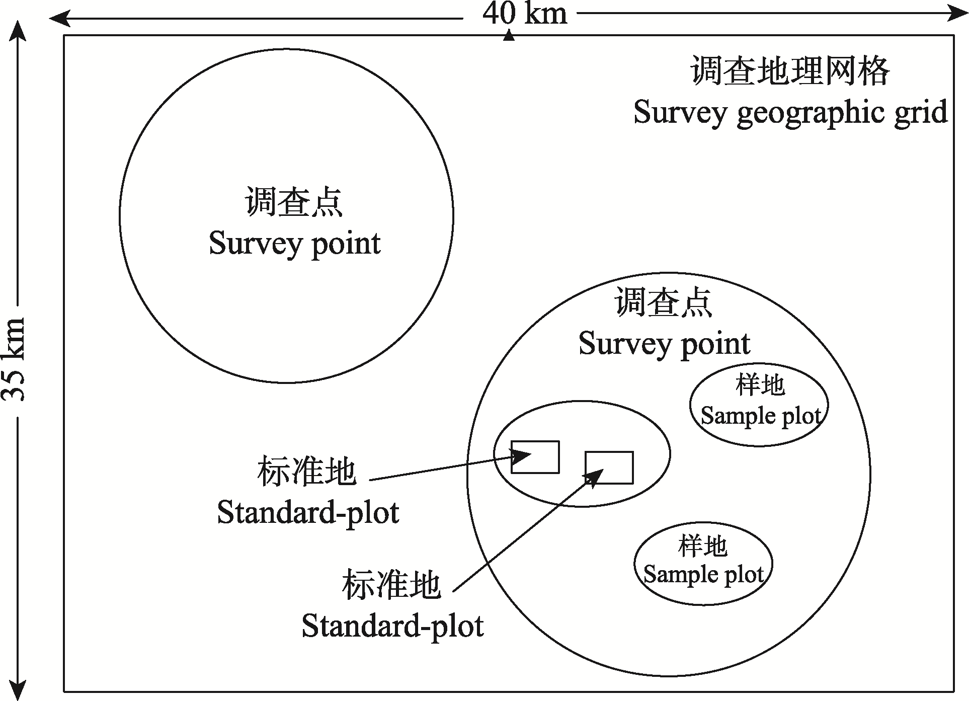
Fig. 1 Spatial relationship of different planning elements for invasive alien plants survey
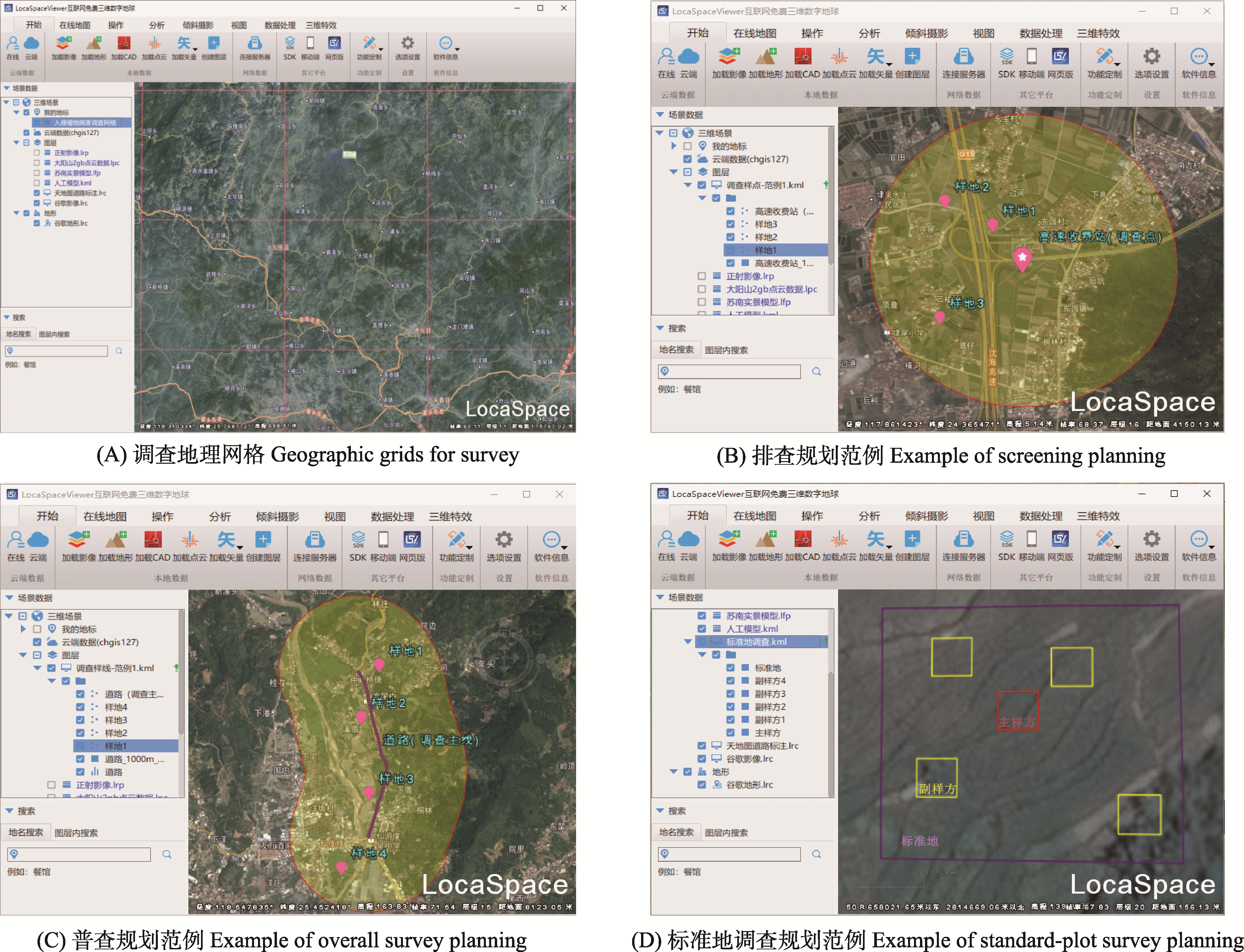
Fig. 2 Sample screen shots of invasive alien plants with survey planning software
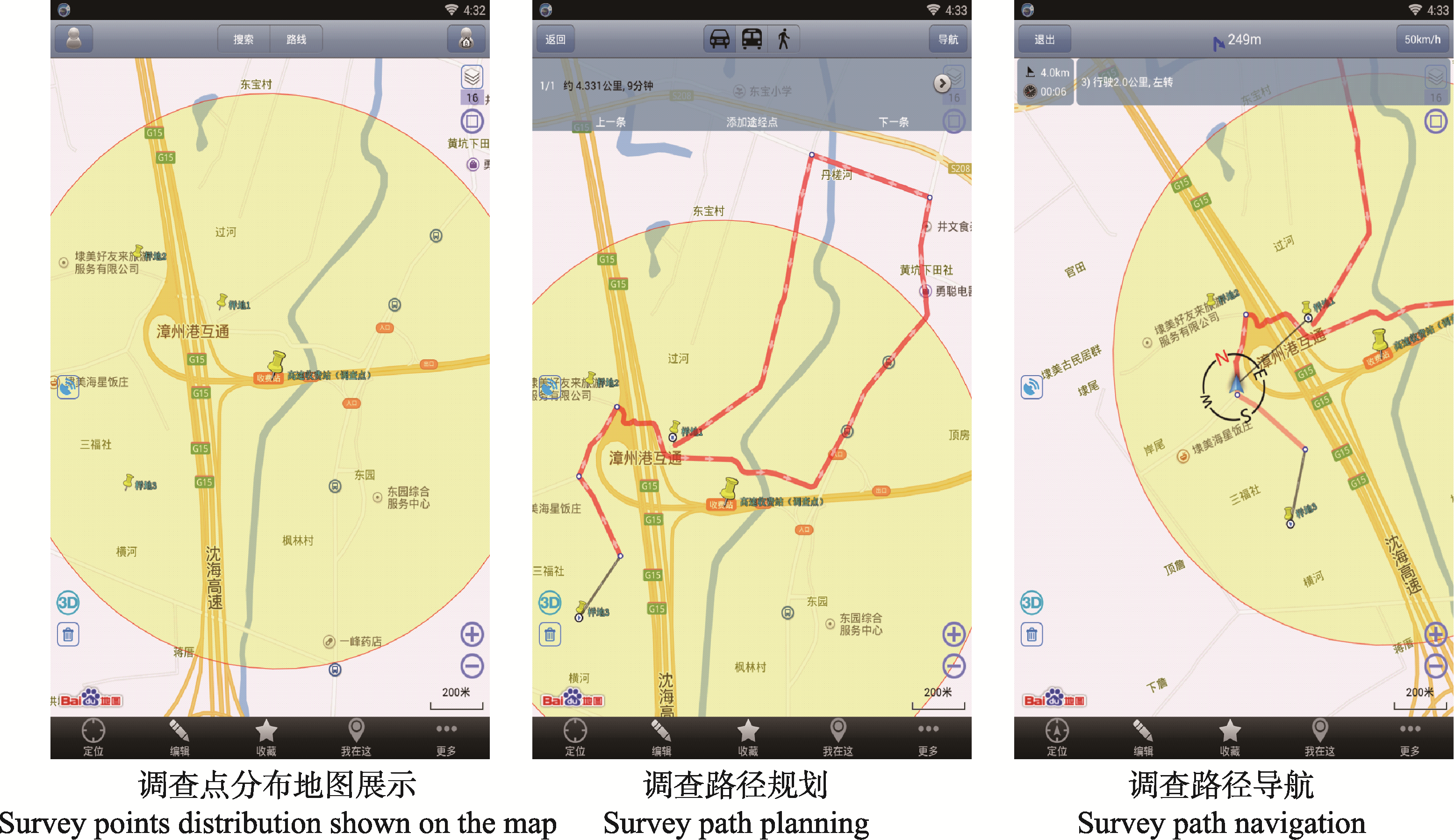
Fig. 3 Function screen shots of Ovital map used in field operation
| 省份 Province | 调查日期 Survey date (Month/day) | 规划普查样地数量 Number of planned survey sample plots | 调查范围 Survey area | 外来入侵植物普查数据统计Statistics of invasive alien plants survey | |||||
|---|---|---|---|---|---|---|---|---|---|
| 农田 Farmland | 湿地 Wetland | 港口 Port | 覆盖县域数量Number of covered counties | 覆盖地理网格数量Number of geographic grids | 调查直线距离 Direct distance of survey (km) | 调查数据量 Number of records | 调查涉及种类 Number of species | ||
| 福建 Fujian | 4/23-25, 5/6-8 | 40 | 0 | 0 | 27 | 29 | 1,100 | 590 | 40 |
| 广西 Guangxi | 3/26-27 | 10 | 0 | 3 | 7 | 7 | 330 | 82 | 28 |
| 云南 Yunnan | 4/12-13 | 6 | 2 | 0 | 7 | 7 | 426 | 132 | 28 |
Table 3 Statistics of invasive alien plants survey in Fujian, Guangxi and Yunnan provinces between March and May, 2017
| 省份 Province | 调查日期 Survey date (Month/day) | 规划普查样地数量 Number of planned survey sample plots | 调查范围 Survey area | 外来入侵植物普查数据统计Statistics of invasive alien plants survey | |||||
|---|---|---|---|---|---|---|---|---|---|
| 农田 Farmland | 湿地 Wetland | 港口 Port | 覆盖县域数量Number of covered counties | 覆盖地理网格数量Number of geographic grids | 调查直线距离 Direct distance of survey (km) | 调查数据量 Number of records | 调查涉及种类 Number of species | ||
| 福建 Fujian | 4/23-25, 5/6-8 | 40 | 0 | 0 | 27 | 29 | 1,100 | 590 | 40 |
| 广西 Guangxi | 3/26-27 | 10 | 0 | 3 | 7 | 7 | 330 | 82 | 28 |
| 云南 Yunnan | 4/12-13 | 6 | 2 | 0 | 7 | 7 | 426 | 132 | 28 |
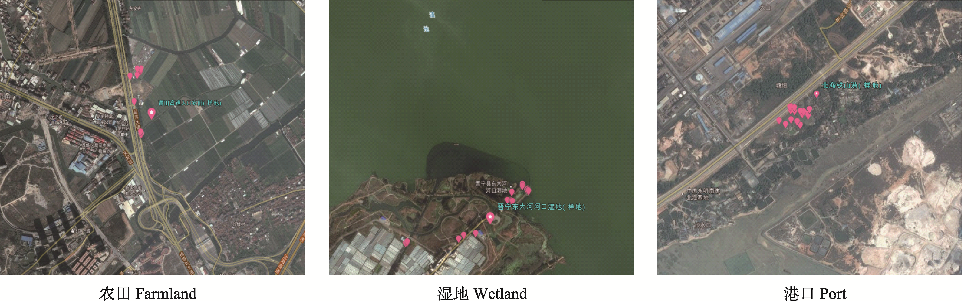
Fig. 4 Spatial distribution of sample plot and data collection points of invasive alien plants survey in three typical ecosystems of farmland, wetland and port
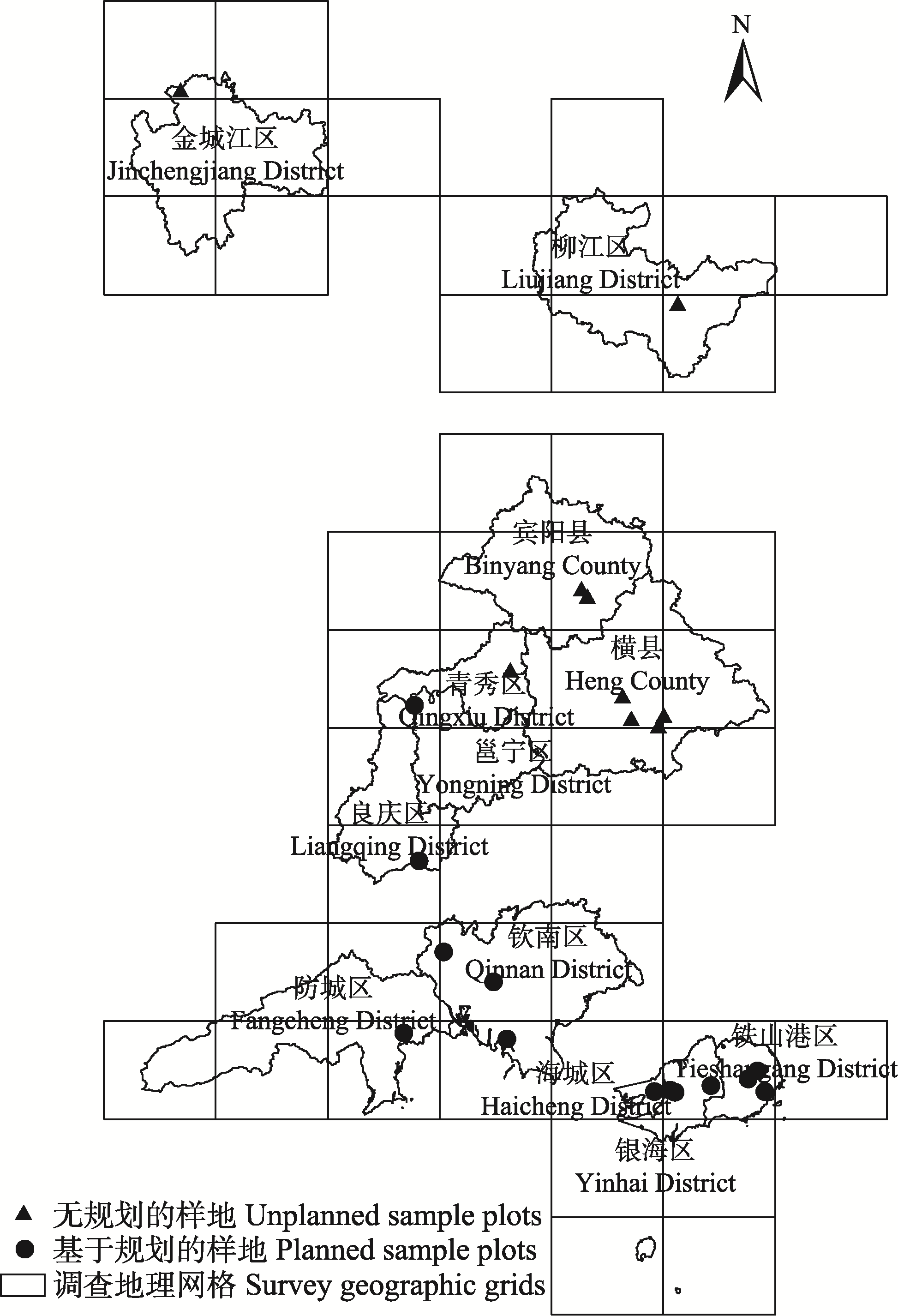
Fig. 5 The spatial distribution of unplanned sample plots and planned sample plots
| 无规划调查 Unplanned survey | 基于规划的调查 Planned survey | |
|---|---|---|
| 覆盖县域数 Number of covered counties | 5 | 7 |
| 覆盖调查地理网格数 Number of covered geographic grids | 6 | 7 |
| 调查样地数量 Number of sample plots | 9 | 13 |
| 调查区生境类型 Habitat types in the survey area | 河岸、农田 Riverside, farmland | 农田、港口、高速公路沿线、荒地、公园、园林绿化 Farmland, Ports, areas along the expressway, wasteland, parks, landscaping |
| 调查点间平均直线距离 Average direct distance between survey points (km) | 53.5 | 30.5 |
| 调查点间直线距离标准差 Standard deviation of direct distance between survey points (km) | 68.2 | 27.7 |
| 调查点间行程平均花费时间 Average cost of travel time between survey points (min) | 128 | 66 |
| 调查点间行程花费时间标准差 Standard deviation of travel time between survey points (min) | 127 | 36 |
Table 4 Comparison of target data for unplanned survey and planned survey
| 无规划调查 Unplanned survey | 基于规划的调查 Planned survey | |
|---|---|---|
| 覆盖县域数 Number of covered counties | 5 | 7 |
| 覆盖调查地理网格数 Number of covered geographic grids | 6 | 7 |
| 调查样地数量 Number of sample plots | 9 | 13 |
| 调查区生境类型 Habitat types in the survey area | 河岸、农田 Riverside, farmland | 农田、港口、高速公路沿线、荒地、公园、园林绿化 Farmland, Ports, areas along the expressway, wasteland, parks, landscaping |
| 调查点间平均直线距离 Average direct distance between survey points (km) | 53.5 | 30.5 |
| 调查点间直线距离标准差 Standard deviation of direct distance between survey points (km) | 68.2 | 27.7 |
| 调查点间行程平均花费时间 Average cost of travel time between survey points (min) | 128 | 66 |
| 调查点间行程花费时间标准差 Standard deviation of travel time between survey points (min) | 127 | 36 |
| 1 | Chen B (2016) Geographic data management, refined route design and precise navigation in biodiversity field surveys. Biodiversity Science, 24, 701-708.(in Chinese with English abstract) |
| [陈彬 (2016) 生物多样性野外调查地理信息管理、路线精细设计和精确导航方法. 生物多样性, 24, 701-708.] | |
| 2 | Ding H, Ma FZ, Wu J, Lei JC, Le ZF, Xu HG (2015) Considerations of building up a supervision and management system for prevention and control of invasive alien species posing environmental hazards in China. Journal of Ecology and Rural Environment, 31, 652-657.(in Chinese with English abstract) |
| [丁晖, 马方舟, 吴军, 雷军成, 乐志芳, 徐海根 (2015) 关于构建我国外来入侵物种环境危害防控监督管理体系的思考. 生态与农村环境学报, 31, 652-657.] | |
| 3 | Fang JY, Wang XP, Shen ZH, Tang ZY, He JS, Yu D, Jiang Y, Wang ZH, Zheng CY, Zhu JL, Guo ZD (2009) Methods and protocols for plant community inventory. Biodiversity Science, 17, 533-548.(in Chinese with English abstract) |
| [方精云, 王襄平, 沈泽昊, 唐志尧, 贺金生, 于丹, 江源, 王志恒, 郑成洋, 朱江玲, 郭兆迪 (2009) 植物群落清查的主要内容、方法和技术规范. 生物多样性, 17, 533-548.] | |
| 4 | Ma LG, Cao YR (2010) Application of Google Earth COM API and KML in tourism information system development. Journal of Geo-Information Science, 12, 828-834. (in Chinese with English abstract) |
| [马立广, 曹彦荣 (2010) Google Earth COM API及KML技术在旅游管理信息系统开发中的应用. 地球信息科学学报, 12, 828-834.] | |
| 5 | McMaugh T (translated by Department of Biological Invasions, Institute of Plant Protection, Chinese Academy of Agricultural Sciences) (2013) Guidelines for Surveillance for Plant Pests in Asia and the Pacific. Science Press, Beijing.(in Chinese) |
| [中国农业科学院植物保护研究所生物入侵研究室(译) (2013) 亚太地区植物有害生物监控指南. 科学出版社, 北京.] | |
| 6 | Sun WT, Liu YT (2010) Research progress of risk analysis of biological invasion. Chinese Agricultural Science Bulletin, 26, 233-236.(in Chinese with English abstract) |
| [孙文涛, 刘雅婷 (2010) 生物入侵风险分析的研究进展. 中国农学通报, 26, 233-236.] | |
| 7 | Wan FH, Feng J, Xu J (2011) Biological Invasions: Detection, Surveillance and Monitoring. Science Press, Beijing.(in Chinese) |
| [万方浩, 冯洁, 徐进 (2011) 生物入侵: 检测与监测篇. 科学出版社, 北京.] | |
| 8 | Wan FH, Guo JY, Wang DH (2002) Alien invasive species in China: Their damages and management strategies. Biodiversity Science, , 119-125.(in Chinese with English abstract) |
| [万方浩, 郭建英, 王德辉 (2002) 中国外来入侵生物的危害与管理对策. 生物多样性, 10, 119-125.] | |
| 9 | Yang LF (2013) Geographic data capturing technique based on Google Maps API V3. Remote Sensing Technology and Application, 28, 791-798.(in Chinese with English abstract) |
| [杨立法 (2013) 基于Google Maps API V3的地理数据采集技术. 遥感技术与应用, 28, 791-798.] |
| [1] | Fuwei Zhao, Yingshuo Li, Hui Chen. Reflections on biodiversity legislation in China’s new era [J]. Biodiv Sci, 2024, 32(5): 24027-. |
| [2] | Di Suo, Ruoxi Yu, Yuanhui Li, Jiliang Xu. Problem review and optimization path of local legislation in nature reserves in China based on empirical analysis [J]. Biodiv Sci, 2024, 32(2): 23287-. |
| [3] | Shaoqi Jia, Jubao Zhang. Necessity and response of the special legislation on access and benefit sharing of biological genetic resources [J]. Biodiv Sci, 2024, 32(11): 24383-. |
| [4] | Li Feng. On synergistic governance of biodiversity and climate change in the perspective of international law [J]. Biodiv Sci, 2023, 31(7): 23110-. |
| [5] | Xiaoming Zheng, Qingwen Yang. Progress of agricultural biodiversity conservation in China [J]. Biodiv Sci, 2021, 29(2): 167-176. |
| [6] | Zhongmei Lü, Zhenliang Chen. Revision of the Law of the People’s Republic of China on the Protection of Wildlife: Background, issues and suggestions [J]. Biodiv Sci, 2020, 28(5): 550-557. |
| [7] | Manling Wu, Lan Yao, Xunru Ai, Jiang Zhu, Qiang Zhu, Jin Wang, Xiao Huang, Jianfeng Hong. The reproductive characteristics of core germplasm in a native Metasequoia glyptostroboides population [J]. Biodiv Sci, 2020, 28(3): 303-313. |
| [8] | Hengning Deng, Wenbin Ju, Yundong Gao, Junyi Zhang, Shiqi Li, Xinfen Gao, Bo Xu. The species composition and distributional characteristics of invasive alien plants along the new Sichuan-Tibet Railway (Ya’an to Changdu section) [J]. Biodiv Sci, 2020, 28(10): 1174-1181. |
| [9] | Junhui Liu, Changxin Zou, Jixi Gao, Su Ma, Wenjie Wang, Kun Wu, Yang Liu. Location determination of ecologically vulnerable regions in China [J]. Biodiv Sci, 2015, 23(6): 725-732. |
| [10] | Jianguo Du, William W.L. Cheung, Bin Chen, Qiulin Zhou, Shengyun Yang, Guanqiong Ye. Progress and prospect of climate change and marine biodiversity [J]. Biodiv Sci, 2012, 20(6): 745-754. |
| [11] | Jie Lin, Wenxuan Xu, Weikang Yang, Canjun Xia, Wei Liu. Habitat suitability assessment of Equus hemionus hemionus in Kalamaili Mountain Nature Reserve [J]. Biodiv Sci, 2012, 20(4): 411-419. |
| [12] | Xingxing Man, Xiangcheng Mi, Keping Ma. Effects of an ice storm on community structure of an evergreen broad- leaved forest in Gutianshan National Nature Reserve, Zhejiang Province [J]. Biodiv Sci, 2011, 19(2): 197-205. |
| [13] | Lisong Wang, Bin Chen, Liqiang Ji, Keping Ma. Progress in Biodiversity Informatics [J]. Biodiv Sci, 2010, 18(5): 429-443. |
| [14] | Weihua Xu, Zhiyun Ouyang, Zeyin Jiang, Hua Zheng, Jianguo Liu. Assessment of giant panda habitat in the Daxiangling Mountain Range, Sichuan, China [J]. Biodiv Sci, 2006, 14(3): 223-231. |
| [15] | Hepeng Li, Liquan Zhang, Donghui Wang. Distribution of an exotic plant Spartina alterniflora in Shanghai [J]. Biodiv Sci, 2006, 14(2): 114-120. |
| Viewed | ||||||
|
Full text |
|
|||||
|
Abstract |
|
|||||
Copyright © 2026 Biodiversity Science
Editorial Office of Biodiversity Science, 20 Nanxincun, Xiangshan, Beijing 100093, China
Tel: 010-62836137, 62836665 E-mail: biodiversity@ibcas.ac.cn