Please wait a minute...
Table of Content
    Volume 24 Issue 11
    20 November 2016

    Chinese Biodiversity Monitoring and Research Network (Sino BON), as a scientific research platform at Chinese Academy of Sciences (CAS) level, was affiliated to Institute of Botany, CAS, with ten thematic networks, one synthesis and data management center. In 2015, Sino BON was formally accepted by Global Biodiversity Observation Network (GEO BON) as a formal member. The figure shows the organization chart of Sino BON.

      
    Full Text
    All Papers in This Issue
    Biodiv Sci. 2016, 24 (11):  0-0. 
    Abstract ( 769 )   PDF (7603KB) ( 3619 )   Save
    Related Articles | Metrics
    Editorial
    Special Feature: Chinese Biodiversity Monitoring and Research Network (Sino BON)
    Chinese forest biodiversity monitoring: scientific foundations and strategic planning
    Xiangcheng Mi, Jing Guo, Zhanqing Hao, Zongqiang Xie, Ke Guo, Keping Ma
    Biodiv Sci. 2016, 24 (11):  1203-1219.  doi:10.17520/biods.2015313
    Abstract ( 2120 )   HTML ( 49 )   PDF (1497KB) ( 3207 )   Save
    Figures and Tables | References | Related Articles | Metrics

    The management and restoration of forest biodiversity is strongly dependent on information regarding biodiversity monitoring. The design of a monitoring network consists of monitoring objects and variables, an effective sampling strategy, data collection and analyses, network maintenance, and organization. Firstly, we reviewed the roles of these components in designing an effective monitoring network. We then introduced five large biodiversity networks, namely, GEO BON (Group on Earth Observations-Biodiversity Observation Network), ForestGEO (Forest Global Earth Observatory), TEAM (Tropical Ecology Assessment and Monitoring Network), Pan-European Forest Monitoring Network, and RAINFOR (Amazonian Forest Inventory Network). Finally, we reviewed the history of Chinese forest biodiversity monitoring, and put forward the aims, monitoring variables and methods, and sampling strategy for forests in the Chinese Biodiversity Monitoring Network. Chinese forest biodiversity monitoring was based on a national forest resource inventory and long-term research of forests ecosystem from 1970s to 1980s. Regulations and methods of biodiversity monitoring were defined during the establishment and operation of the Chinese Forest Biodiversity Monitoring Networks (Sino BON-CForBio). Sino BON-CForBio has important achievements in biodiversity monitoring and maintenance. The planning aims of Sino BON-CForBio include: (1) to study biodiversity maintenance mechanisms of typical zonal forests, (2) to monitor trends of forest biodiversity change and to explore mechanisms at the national scale, and (3) to study the effects of biodiversity change based on manipulation experiments. Results will provide scientific foundations for management and restoration of forest biodiversity. The framework and sampling strategy of Sino BON-CForBio are based on the regionalization of forest vegetation. The framework for Sino BON-CForBio includes four levels of forest biodiversity monitoring. We will integrate essential biodiversity variables and indicators of conventional forest surveys as monitoring variables for Sino BON-CForBio. Sino BON-CForBio aims to establish forest biodiversity monitoring networks at the national scale and will continue to explore mechanisms of biodiversity maintenance and the effects of biodiversity change. In addition, Sino BON-CForBio will monitor the effectiveness of biodiversity conservation and validate the mechanisms of biodiversity change for key ecological conservation projects.

    Methods of observing typical plant communities in the Steppe and Desert Biodiversity Observation Network, Sino BON
    Ke Guo, Changcheng Liu, Qingmin Pan
    Biodiv Sci. 2016, 24 (11):  1220-1226.  doi:10.17520/biods.2016190
    Abstract ( 1433 )   HTML ( 19 )   PDF (353KB) ( 2284 )   Save
    Figures and Tables | References | Related Articles | Metrics

    A typical plant community that reflects the basic community characteristics of a vegetation classification unit can be designated as the standard for describing a distinct vegetation type. The Steppe and Desert Biodiversity Observation Network of Sino BON aims to establish a series of typical plant community plots for long-term biodiversity observations using standardized methods. This paper emphasizes the importance of plant community observations for the study of biodiversity, defines the concept of a typical plant community, and introduces a system of typical plant community observations including the framework, primary observations, methods, parameters, and predictable output.

    Theory and methods on fish diversity monitoring with an introduction to the inland water fish diversity observation in China
    Huanzhang Liu, Junxing Yang, Shuwei Liu, Xin Gao, Yushun Chen, Chunguang Zhang, Kai Zhao, Xinhui Li, Wei Liu
    Biodiv Sci. 2016, 24 (11):  1227-1233.  doi:10.17520/biods.2016031
    Abstract ( 2276 )   HTML ( 27 )   PDF (270KB) ( 2548 )   Save
    Figures and Tables | References | Related Articles | Metrics

    In recent years, the establishment of biodiversity observation networks (BON) has been of great concern. The global scale GEO-BON (Global Earth Observation—Biodiversity Observation Network), regional EBONE (European Biodiversity Observation Network) and AP BON (Asia-Pacific BON), and local networks such as the J-BON (Japanese BON) and French BON have been successful. The introduction of Essential Biodiversity Variables (EBV) has laid a theoretical foundation for biodiversity observations. The fish biodiversity observation theory is embedded in the EBV, and includes work at the genetic, species, and ecosystem levels. Originally designed for fish monitoring, the index of biotic integrity (IBI) has become the most popular index, and emphasizes the identification of different ecological functional groups, which can reflect changes in community structure and function. Fish diversity survey methods include both traditional nets and modern instruments such as a hydroacoustic sonar system. Analysis of monitoring data can be completed as simple comparisons of various indices, modeling long term trends to identify change-points, and exploring ecological regime shifts. As a part of the Chinese Biodiversity Monitoring and Research Network (Sino BON)—Inland Water Fish is designed to conduct fish monitoring work in 8 major drainage basins in China including the Yangtze River, the Yellow River, the Heilongjiang River, the Zhujiang River, the Lancang River, the Nujiang (Salween) River, the Tarim River, and the Qinhaihu Lake. A total of 25 focused areas and 24 targeted species (groups) have been selected as sampling sites and crucial indicators, respectively, and monitoring variables including community structure, population structure and dynamics, biological traits, genetic diversity, and fish early resources.

    Thematic monitoring network of soil fauna diversity in China: exploring the mystery of soils
    Kaiwen Pan, Lin Zhang, Yuanhu Shao, Shenglei Fu
    Biodiv Sci. 2016, 24 (11):  1234-1239.  doi:10.17520/biods.2016019
    Abstract ( 1678 )   HTML ( 17 )   PDF (690KB) ( 2705 )   Save
    References | Related Articles | Metrics

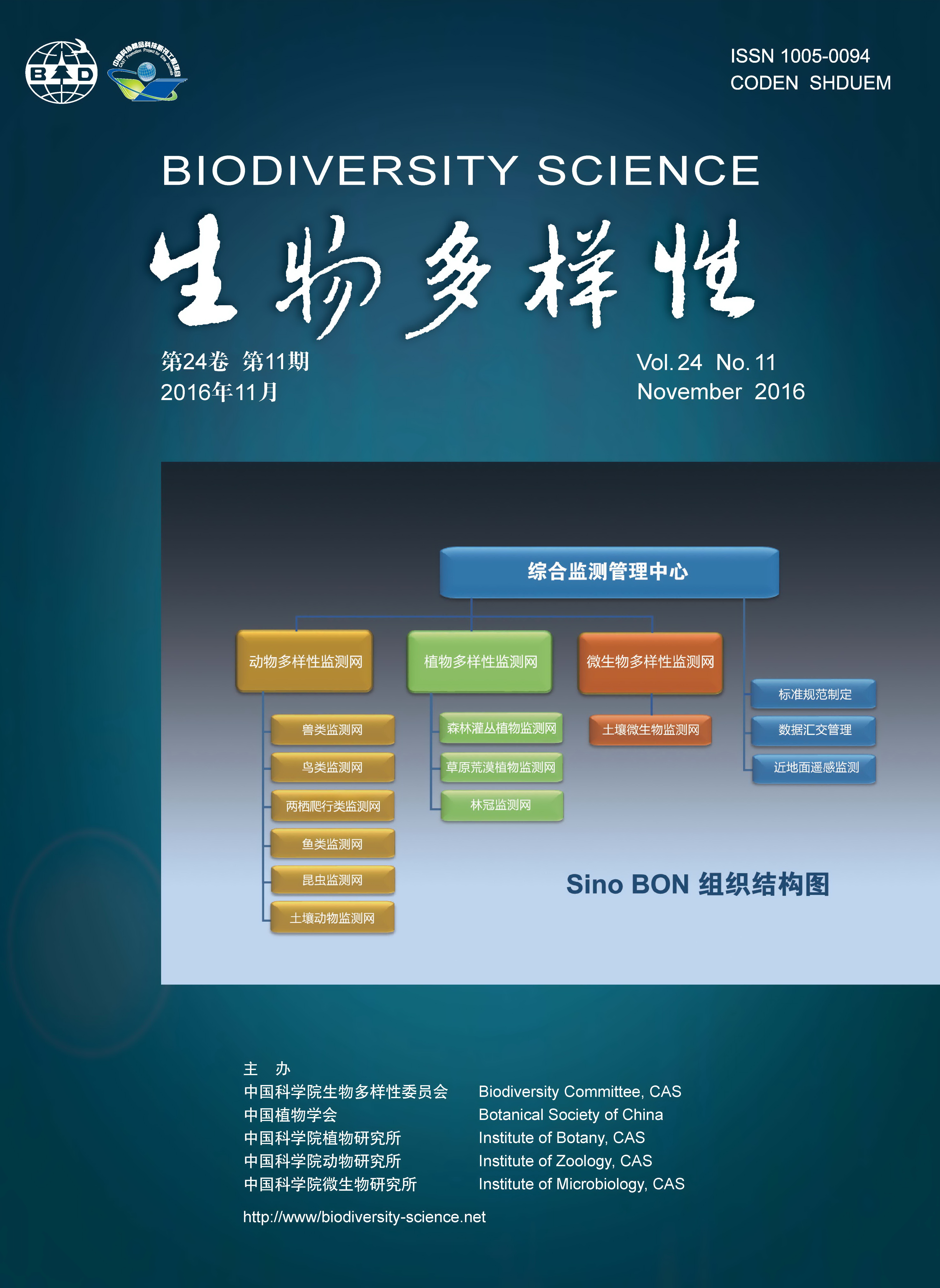
    The important roles of soil fauna diversity and associated indicative functions of environment changes have received increasing attention from both academic circles and government decision makers. This paper summarizes the current situation of soil fauna monitoring in developed countries and related work in China. We introduce the objectives and structure of the thematic monitoring network of soil fauna diversity (TMNSFD), and highlighted some aspects that need attention. The TMNSFD proposed to establish permanent monitoring plots within forest plots established by Chinese Forest Biodiversity Monitoring Network for monitoring soil fauna including earthworms, mites, springtails, nematodes and protists. During the years 2016-2020, TMNSFD may choose typical forest ecosystems as priority ecosystems for soil fauna monitoring, which cover temperate forest ecosystems (including broadleaved Korean pine mixed forests in Changbaishan, Jilin Province and warm temperate deciduous broadleaved forests in Donglingshan, Beijing), subtropical forest ecosystems (including typical subtropical evergreen broadleaved forests in Gutianshan, Zhejiang Province, lower subtropical evergreen broadleaved forests in Dinghushan, Guangdong Province, and north subtropical evergreen broad-leaved forests in Dujiangyan, Sichuan Province), tropical forest ecosystems (tropical rainforests in Xishuangbanna, Yunnan Province and Jianfengling, Hainan Province), as well as mountainous dark coniferous forests in Liziping, Sichuan Province. By 2030, TMNSFD soil fauna monitoring plots may cover various ecosystems including forests, grasslands, wetlands, deserts, farmland, urban areas and other typical ecosystems in different regions of China. TMNSFD emphasizes the value of applied molecular biology technology, unified monitoring methods, and manipulation experiments to simulate the effects of global change on soil fauna during the processes of monitoring. We propose monitoring soil fauna diversity once every 5 years in established monitoring plots. The objective of TMNSFD is to provide reliable and integrated data of soil fauna diversity via the establishment of standard monitoring methods and a data-sharing network at the national level, which could support the development of ecological civilization in China.

    Soil microbial diversity observation in China: current situation and future consideration
    Xiangzhen Li, Liangdong Guo, Jiabao Li, Minjie Yao
    Biodiv Sci. 2016, 24 (11):  1240-1248.  doi:10.17520/biods.2015345
    Abstract ( 2375 )   HTML ( 42 )   PDF (4323KB) ( 4732 )   Save
    Figures and Tables | References | Related Articles | Metrics

    Soil microbial diversity has not been extensively observed due to technique limitations. With the development of the high-throughput sequencing technique and bioinformatics, much progress has been made in observations of microbial diversity. Currently, international microbiome initiatives have been founded (including the Earth Microbial Project). However, problems in these projects include a lack of dynamic observations, differences in observational methods, and data integration. The soil microbial observation network (SMON) is an important part of the Chinese Biodiversity Monitoring and Research Network (Sino BON). The observational network initially selected field observation sites in forest ecosystems along a temperature and precipitation gradient from south to north, in grassland ecosystems along a precipitation transect from east to west, and in typical wetland and agricultural ecosystems in China. Field ecological observation stations have been established in these selected ecosystems. Key tasks for the SMON are to observe spatial and temporal dynamics of soil microbial communities and functional genes in various ecosystems, including bacteria, archaea, fungi, and lichens. Observational data will be published periodically in the format of database, annals, and illustrated handbooks. Key methods used in the SMON are high- throughput sequencing, metagenomics, and bioinformatics. A soil biota database is currently being constructed to store observational data for public inquiry and analysis. Through the efforts of SMON, we plan to explore the driving mechanisms of spatial and temporal variations of soil microbial communities and their functional genes, and understand the relationships between microbial diversity and ecosystem function, in order to predict microbial dynamics under global environmental change scenarios, and to design strategies to protect soil microbial diversity and properly utilize microbial resources.

    A near-surface remote sensing platform for biodiversity monitoring: perspectives and prospects
    Qinghua Guo, Jin Liu, Yumei Li, Qiuping Zhai, Yongcai Wang, Fangfang Wu, Tianyu Hu, Huawei Wan, Huiming Liu, Wenming Shen
    Biodiv Sci. 2016, 24 (11):  1249-1266.  doi:10.17520/biods.2016059
    Abstract ( 3152 )   HTML ( 61 )   PDF (1050KB) ( 3590 )   Save
    Related Articles | Metrics

    In recent years, the Chinese Biodiversity Monitoring and Research Network (Sino BON) has developed rapidly, which provides an unprecedented platform for long-term biodiversity monitoring and research. The near-surface remote sensing (NsRS) platform, an important component of the Sino BON-Synthesis (Synthesis Center of Sino BON) and equipped with LiDAR (Light Detection and Ranging) as the core technique, has developed a mature technology system integrating hardware and software, which can provide digital products such as topographic modeling under forest, stand height, stand surface structure, gap or internal boundaries, canopy closure dynamics, vegetation community division, fine spatial structure within the community, individual tree height and diameter at breast height, canopy morphology, circumference and cover, species identification, sub-meter three-dimensional landscape map and so on. Therefore it can be used to acquire multiple spatiotemporal scales of biodiversity observations and offer scientists and managers specialized and effective technical support for biodiversity evaluation and conservation. In this paper, we provide a comprehensive review on the history and recent development of remote sensing technology in biodiversity studies. Then, we summarize the important indices of biodiversity that can be extracted from remote sensing data based on the direct and indirect methods for remote sensing monitoring of biodiversity and suggest spatial and temporal scales that should be referenced against the selection of different types of remote sensing data. Next we describe in detail the application of the state-of-the-art NsRS platform at home and abroad and figure out that the near-surface remote sensing platform represented by unmanned aerial vehicle (UAV), characterized by flexibility, high efficiency, low cost and high resolution, will be an important means for biodiversity monitoring in the near future. Because it can act as an indispensable intermediate bridge between satellite platform, manned aviation platform and ground survey platform when conducting the biodiversity information scaling. Finally, based on currently available techniques and equipment of the NsRS platform, we conclude that further improvement of the platform construction will greatly help us to obtain three-dimensional quantitative habitat information. And it will be a long-term, significant step for the biodiversity observation network in China to have transformed into an intelligent decision and service platform with trans-scale hierarchy dynamic monitoring ability and multi-source information integration technology.

    Perspectives and prospects of unmanned aerial vehicle in remote sensing monitoring of biodiversity
    Qinghua Guo, Fangfang Wu, Tianyu Hu, Linhai Chen, Jin Liu, Xiaoqian Zhao, Shang Gao, Shuxin Pang
    Biodiv Sci. 2016, 24 (11):  1267-1278.  doi:10.17520/biods.2016105
    Abstract ( 3503 )   HTML ( 81 )   PDF (1138KB) ( 4153 )   Save
    Figures and Tables | References | Related Articles | Metrics

    During the past decade, unmanned aerial vehicle (UAV) based remote sensing has been increasingly used in the fields of vegetation inventory, natural resource management, and biodiversity conservation, due to its low cost and high flexibility. In this study, we present a reference for the selection of UAV platforms and remote sensing sensors, by introducing a UAV classification system and summarizing applicability in biodiversity monitoring using remote sensing techniques. For each UAV platform category, we also introduce the characteristics and capabilities of different remote sensing sensors that can be supported. Moreover, through the combination of a case study which collected high-fidelity UAV-based remotely sensed data, we discuss current research progress using UAV-borne remote sensing data to derive direct and indirect biodiversity parameters. Finally, we discuss the current limitations of UAV-based remote sensing platforms for biodiversity monitoring, such as the existing gap between hardware and software, the high cost of certain components (e.g. the initial measurement unit), incomplete laws and regulations, and the disconnect with traditional biodiversity monitoring methods. In summary, we believe that UAV-based remote sensing platforms can greatly help to fill the gaps between terrestrial measurements and aerial/spaceborne measurements, and can increase the accuracy and reliability of upscaling point-based terrestrial measurements to the regional scale. There is a need to launch more projects that address building a UAV-based biodiversity monitoring network, and therefore improve our capability to analyze and forecast biodiversity changes in hotspots.

    Original Papers: Plant Diversity
    Effects of different sediment type and burial depth on growth traits and biomass accumulation of Spartina anglica
    Lin Liu, Shuqing An, Yingbiao Zhi, Mingxiang Zhang, Hongli Li
    Biodiv Sci. 2016, 24 (11):  1279-1287.  doi:10.17520/biods.2016024
    Abstract ( 1588 )   HTML ( 4 )   PDF (479KB) ( 2075 )   English Version Save
    Figures and Tables | References | Related Articles | Metrics

    Soils in salt marsh ecosystems have been undergoing certain changes including those related to sediment types and burial depths due to tidal activity and a variety of biotic factors. The changes in sediment type affect water-retaining properties, permeability and organic content while those in burial depth alter soil humidity, nutrition content, oxygen content, light intensity and temperature. Although many previous studies have focused on the effects of soil properties on plant growth and reproduction, few have explicitly tested the impacts of sediment type and burial depth on plants in salt marsh ecosystems. The exotic species Spartina anglica found in coastal China has been experiencing increased mortality over the past decade, however the mechanism of this mortality remains unclear. This study mainly focused on the effects of sediment type and burial depth on growth traits and biomass accumulation of S. anglica and was conducted under greenhouse conditions. The experiment included two types of sediments with clay and clay-sand mixtures (the volume of 1:1). Furthermore, four treatments were established with burial depths from 0 cm to one quarter of the plant height, one half of the plant height and three quarters of the plant height. Results indicated that clay increased leaf area, number of leaves, number of rhizomes, total length of rhizomes, rhizome mass and aboveground mass, while the clay-sand mixture led to an increase in the number of ramets, total mass, underground mass and root mass. All of the measures, except for leaf area, peaked at one half of the plant height burial treatment among all treatments. Overall, burial depth at one half of the plant height in clay was the most suitable combination for S. anglica. The results indicate that changes in sediment properties and subsequent changes in burial depth for S. anglica may assist with management of its populations over the species range.

    Original Papers: Animal Diversity
    The effect of Flaveria bidentis litter decomposition on the structure of arthropod communities
    Jing Yan, Guoliang Zhang, Ruihai Zhang, Zhen Song, Xiaohong Zhao, Yusheng Liu, Weidong Fu
    Biodiv Sci. 2016, 24 (11):  1288-1295.  doi:10.17520/biods.2016047
    Abstract ( 1277 )   HTML ( 4 )   PDF (671KB) ( 2009 )   Save
    Figures and Tables | References | Related Articles | Metrics

    An investigation was conducted between fall 2014 and 2015 to illustrate litter decomposition of the non-native plant species Flaveria bidentis and its effects on the structure of local arthropod communities. The survey was implemented in four different habitats, including forestland, cultivated fields, uncultivated land and ditches, which were all invaded by F. bidentis. The collection yielded a total number of 17,466 individuals belonging to 8 classes from 18 orders dominated by Arachnoidea and Psocoptera. In all habitat types, the numbers of arthropod individuals collected from F. bidentis treatments were noticeably more than those collected from neighboring plants as a control treatment (by 11-53%). Throughout the survey season, species richness and diversity index of arthropods were usually higher in the F. bidentis litter than those in the control, and reached significant levels at the peak of F. bidentis growth. Results also showed that F. bidentis litter decomposed faster than the litter of neighboring plants. Other results also suggested that the effects of F. bidentis litter on arthropod might be associated with the extent of human disturbance, indicating that habitats rarely visited by humans such as uncultivated land and ditches might be affected more than forestland and cultivated fields, which had greater intensity of human activity. In summary, the invasion of F. bidentis changes the community structure of arthropods and increases the diversity of arthropods in four habitat types.

    Estimation of species richness of moths (Insecta: Lepidoptera) based on DNA barcoding in Suqian, China
    Qian Jin, Fen Chen, Guijie Luo, Weijia Cai, Xu Liu, Hao Wang, Caiqing Yang, Mengdi Hao, Aibing Zhang
    Biodiv Sci. 2016, 24 (11):  1296-1305.  doi:10.17520/biods.2016202
    Abstract ( 1412 )   HTML ( 17 )   PDF (1425KB) ( 3318 )   English Version Save
    Figures and Tables | References | Related Articles | Metrics

    To explore the feasibility of assessing species diversity using DNA barcoding, we investigated this approach by focusing on moths species (Lepidoptera) in Suqian, China. The study evaluated community species richness and rank-abundance curves using the DNA barcoding method, and compared it with the traditional morphology method. Results indicated that there was no significant difference between the DNA barcode-based approach and the morphology-based approach. All DNA barcode-based rank-abundance curves gave similar and clear patterns when compared with morphology-based curves (Kolmogorov-Smirnov two sample test, P > 0.05). Our results indicate that the DNA barcode-based approach is able to be used to estimate species richness.

    Taxonomic diversity of crustaceans in Yellow Sea and Bohai Sea
    Qiang Wu, Zhongyi Li, Fangqun Dai, Ruisheng Chen, Jun Wang, Xiujuan Shan, Xianshi Jin
    Biodiv Sci. 2016, 24 (11):  1306-1314.  doi:10.17520/biods.2016250
    Abstract ( 1476 )   HTML ( 18 )   PDF (1124KB) ( 3083 )   English Version Save
    Figures and Tables | References | Related Articles | Metrics

    To reveal the taxonomic diversity of crustaceans in Yellow Sea and Bohai Sea, a species list of crustaceans (Malacostraca: Decapoda and Stomatopoda) was obtained by the Yellow Sea Fisheries Research Institute, Chinese Academy of Fishery Sciences, using survey data collected by bottom trawling from 2010 to 2015. A total species list of crustaceans was also obtained by combining the species list above with historical literature. Based on the above two lists, the inclusion index at taxonomic level (TINCLi), average taxonomic distinctness index (Δ+) and variation in taxonomic distinctness index (Λ+) were computed. A total of 93 species of crustaceans, belonging to 2 orders, 39 families, and 66 genera, were recorded from 2010 to 2015. Among these, 10 species were newly recorded. Penaeidae, Hippolytidae, Palaemonidae, Portunidae and Varunidae were among the top 5 families, accounting for 38.71% of the total species. TINCLi were 1.41 species/genus and 2.38 species/family, respectively. Δ+ and Λ+ were 50.25 and 35.20, respectively. According to the total species list, a total of 228 species of crustaceans were recorded, belonging to 2 orders, 53 families, and 123 genera. Hippolytidae, Pinnotheridae, Penaeidae, Varunidae and Alpheidae were among the top 5 families, accounting for 30.70% of the total species. TINCLi were 1.85 species/genus and 4.30 species/family. Δ+ and Λ+ were 50.18 and 30.87, respectively. The relative richness index (Rr) of Penaeidae (100) was the highest, followed by Portunidae (71.43) and Palaemonidae (62.50). The relative richness index (Rr) of Pinnotheridae (6.25) was the lowest. The average taxonomic distinctness index (Δ+) of crustaceans was less than that of fish in Yellow Sea and Bohai Sea (P < 0.05). The value of Δ+ calculated by recent surveys was higher than the theoretical value and was within the 95% confidence intervals. This result shows that crustacean species in Yellow Sea and Bohai Sea were being intermediately disturbed.


  • wechat:swdyx_wx