
Biodiv Sci ›› 2018, Vol. 26 ›› Issue (9): 931-940. DOI: 10.17520/biods.2018059 cstr: 32101.14.biods.2018059
• Original Papers: Plant Diversity • Previous Articles Next Articles
Hongfei Zhuang1,2, Yinbo Zhang3, Wei Wang1,4,*( ), Yueheng Ren1, Fangzheng Liu1, Jinhong Du1, Yue Zhou1
Received:2018-02-13
Accepted:2018-05-15
Online:2018-09-20
Published:2019-01-05
Contact:
Wang Wei
About author:# Co-first authors
Hongfei Zhuang, Yinbo Zhang, Wei Wang, Yueheng Ren, Fangzheng Liu, Jinhong Du, Yue Zhou. Optimized hot spot analysis for probability of species distribution under different spatial scales based on MaxEnt model: Manglietia insignis case[J]. Biodiv Sci, 2018, 26(9): 931-940.
| 尺度 Scale | 覆盖范围 Cover range | 红色木莲分布现状 Distribution status of Manglietia insignis |
|---|---|---|
| 三江并流 Three Parallel Rivers | 泸水县、兰坪白族普米族自治县、玉龙纳西族自治县、福贡县、维西傈僳族自治县、德钦县、贡山独龙族怒族自治县和香格里拉市8个行 政县, 约4.5万km2 Including Lushui County, Lanping Bai Pumi Autonomous County, Yulong Naxi Autonomous County, Fugong County, Weixi County, Deqin County, Gongshan County, and Shangri-La City, about 45,000 km2 | 泸水县、福贡县、德钦县和贡山独龙族怒族自治县有其分布记录 Lushui County, Fugong County, Deqin County, and Gongshan County with distribution records |
| 云南省 Yunnan Province | 包含昆明市、玉溪市和迪庆藏族自治州等16个州市, 约39万km2 Containing 16 cities, such as Kunming, Yuxi, and Dêqên Tibetan Autonomous Prefecture, about 390,000 km2 | 临沧市、普洱市和玉溪市等12个州市有其分布 记录 Twelve cities including Lincang City, Puer City, and Yuxi with distribution records |
| 全国 Country | 包含省、自治区、直辖市及特别行政区在内的34个省级行政区域, 约 960万km2 Containing 34 provincial administrative regions, including provinces, autonomous regions, municipalities, and special administrative regions, about 9,600,000 km2 | 湖北、湖南、福建、广西、四川、贵州、云南和西藏8省有其分布记录 Hubei, Hunan, Fujian, Guangxi, Sichuan, Guizhou, Yunnan, Tibet with distribution records |
Table 1 Scale setting of the study areas and the distribution status of Manglietia insignis
| 尺度 Scale | 覆盖范围 Cover range | 红色木莲分布现状 Distribution status of Manglietia insignis |
|---|---|---|
| 三江并流 Three Parallel Rivers | 泸水县、兰坪白族普米族自治县、玉龙纳西族自治县、福贡县、维西傈僳族自治县、德钦县、贡山独龙族怒族自治县和香格里拉市8个行 政县, 约4.5万km2 Including Lushui County, Lanping Bai Pumi Autonomous County, Yulong Naxi Autonomous County, Fugong County, Weixi County, Deqin County, Gongshan County, and Shangri-La City, about 45,000 km2 | 泸水县、福贡县、德钦县和贡山独龙族怒族自治县有其分布记录 Lushui County, Fugong County, Deqin County, and Gongshan County with distribution records |
| 云南省 Yunnan Province | 包含昆明市、玉溪市和迪庆藏族自治州等16个州市, 约39万km2 Containing 16 cities, such as Kunming, Yuxi, and Dêqên Tibetan Autonomous Prefecture, about 390,000 km2 | 临沧市、普洱市和玉溪市等12个州市有其分布 记录 Twelve cities including Lincang City, Puer City, and Yuxi with distribution records |
| 全国 Country | 包含省、自治区、直辖市及特别行政区在内的34个省级行政区域, 约 960万km2 Containing 34 provincial administrative regions, including provinces, autonomous regions, municipalities, and special administrative regions, about 9,600,000 km2 | 湖北、湖南、福建、广西、四川、贵州、云南和西藏8省有其分布记录 Hubei, Hunan, Fujian, Guangxi, Sichuan, Guizhou, Yunnan, Tibet with distribution records |
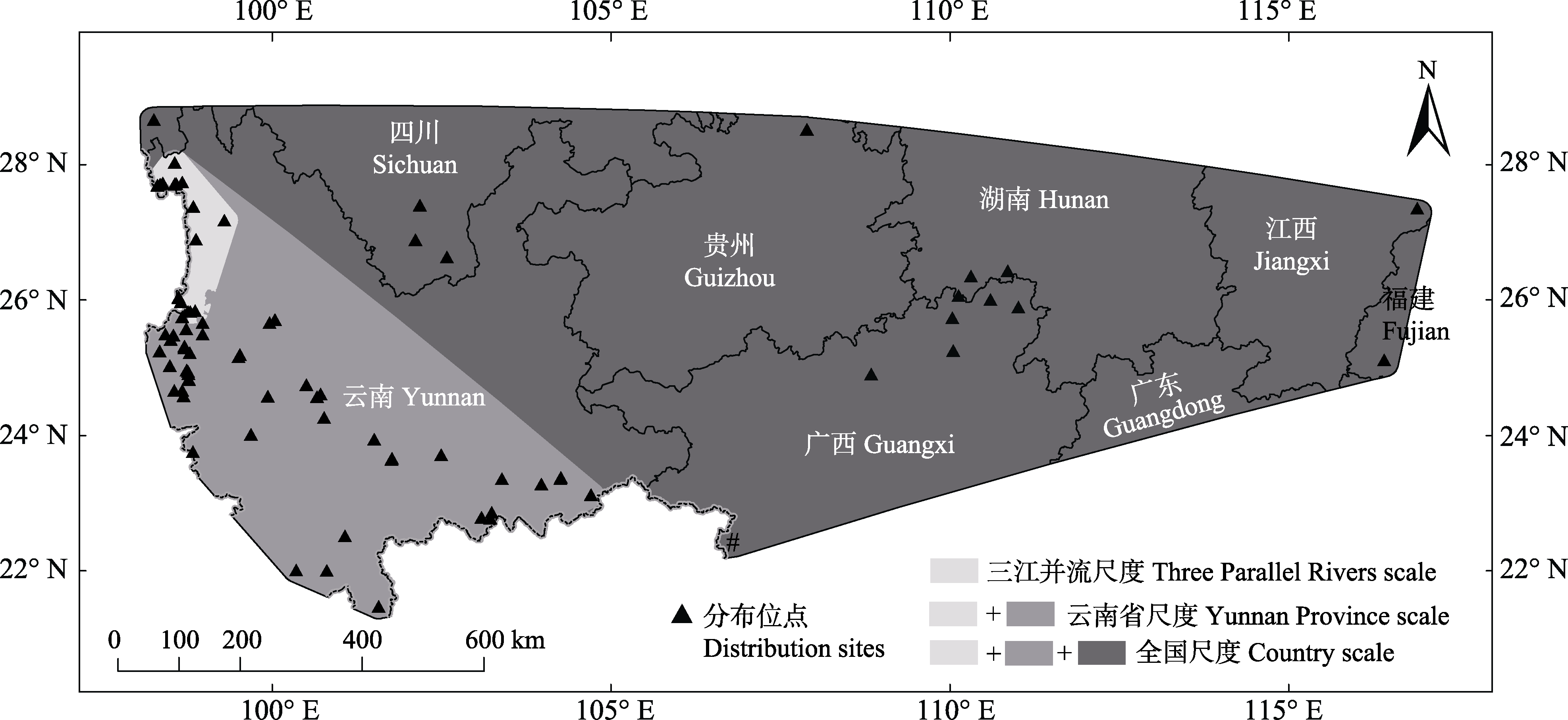
Fig. 1 Modeling areas of three spatial scales and distribution sites of Manglietia insignis
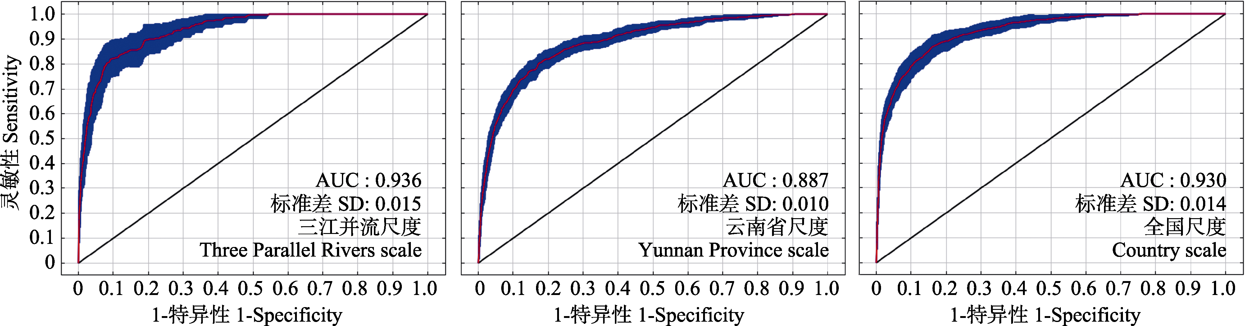
Fig. 2 Receiver operating characteristic curve of three spatial scales and area under the curve (AUC)
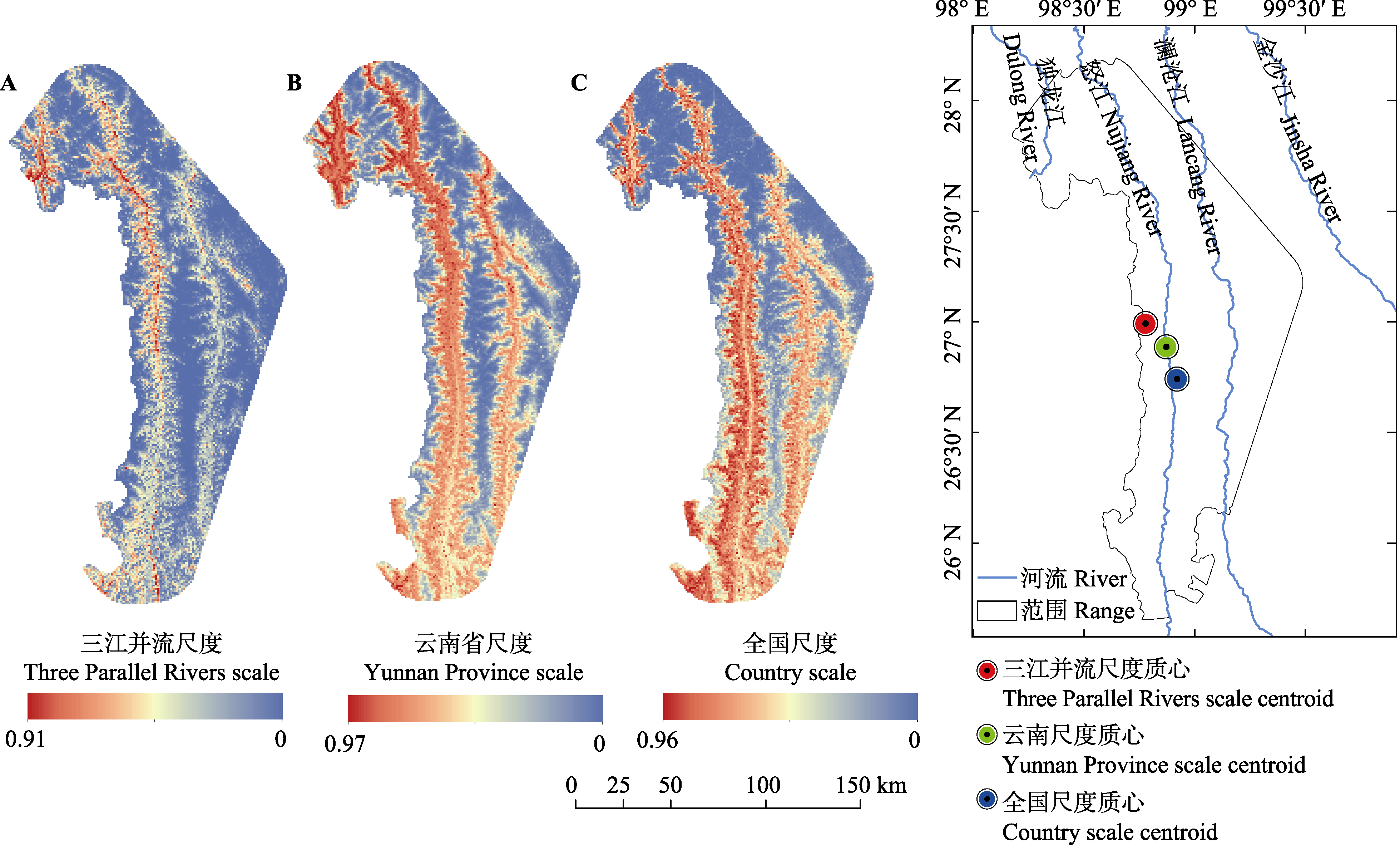
Fig. 3 Potential suitable distributions and its centroids of Manglietia insignis under three spatial scales
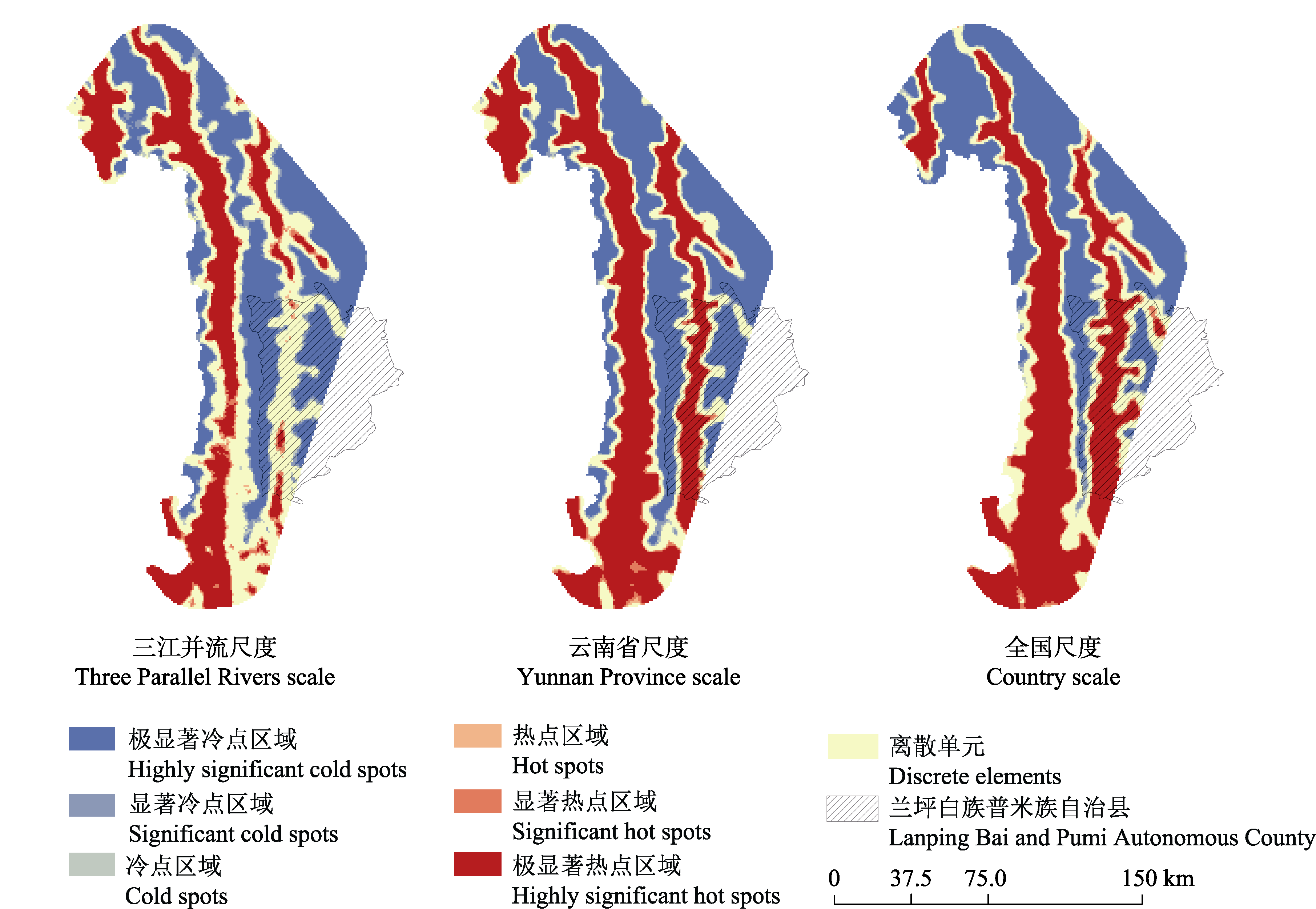
Fig. 4 Optimized hot spot analysis of probability distribution of Manglietia insignis under three spatial scales
| 尺度 Scale | 变量 Variable | 环境因子贡献率 Contribution (%) | 尺度 Scale | 变量 Variable | 环境因子贡献率 Contribution (%) |
|---|---|---|---|---|---|
| 三江并流尺度 TPRS | b1 | 3.4 | b15 | 13.7 | |
| b2 | 9.8 | alt | 2.9 | ||
| b4 | 6.2 | slo | 10.1 | ||
| b15 | 11 | asp | 3.5 | ||
| alt | 39.4* | 全国尺度 CS | b1 | 5.9 | |
| slo | 8.1 | b2 | 24.8* | ||
| asp | 22.1* | b7 | 21.7* | ||
| 云南省尺度 YPS | b1 | 5.1 | b12 | 11.4 | |
| b2 | 8.9 | b18 | 14.1 | ||
| b4 | 18.8 | alt | 7.1 | ||
| b12 | 35.5* | slo | 10.4 | ||
| b14 | 1.6 | asp | 4.7 |
Table 2 Contribution of environmental variables for Manglietia insignis under Three Parallel Rivers scale (TPRS), Yunnan Province scale (YPS), and country scale (CS)
| 尺度 Scale | 变量 Variable | 环境因子贡献率 Contribution (%) | 尺度 Scale | 变量 Variable | 环境因子贡献率 Contribution (%) |
|---|---|---|---|---|---|
| 三江并流尺度 TPRS | b1 | 3.4 | b15 | 13.7 | |
| b2 | 9.8 | alt | 2.9 | ||
| b4 | 6.2 | slo | 10.1 | ||
| b15 | 11 | asp | 3.5 | ||
| alt | 39.4* | 全国尺度 CS | b1 | 5.9 | |
| slo | 8.1 | b2 | 24.8* | ||
| asp | 22.1* | b7 | 21.7* | ||
| 云南省尺度 YPS | b1 | 5.1 | b12 | 11.4 | |
| b2 | 8.9 | b18 | 14.1 | ||
| b4 | 18.8 | alt | 7.1 | ||
| b12 | 35.5* | slo | 10.4 | ||
| b14 | 1.6 | asp | 4.7 |
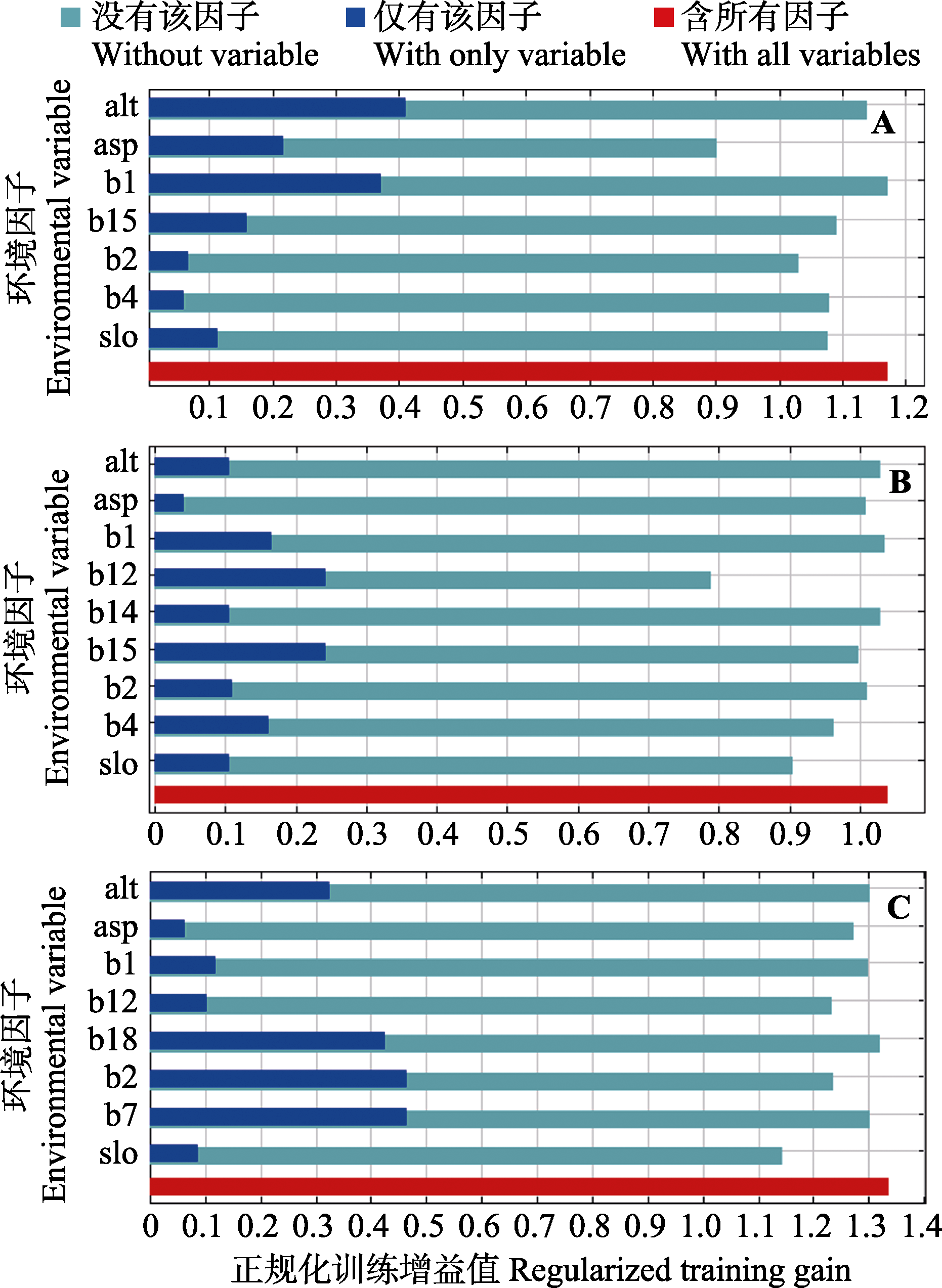
Fig. 5 Results of Jackknife evaluation of the environmental variables with respect to regularized training gain for Three Parallel Rivers scale (A), Yunnan Province scale (B), and country scale (C)
| [1] | Ahmed SE, McInerny G, O’Hara K, Harper R, Salido L, Emmott S, Joppa LN (2015) Scientists and software—surveying the species distribution modelling community. Diversity and Distributions, 21, 258-267. |
| [2] | Barbosa FG, Schneck F (2015) Characteristics of the top-cited papers in species distribution predictive models. Ecological Modelling, 313, 77-83. |
| [3] | Catherineh G, Jane E, Robertj H, Antoine G, Townsend PA, Bettea L (2008) The influence of spatial errors in species occurrence data used in distribution models. Journal of Applied Ecology, 45, 239-247. |
| [4] | Chai Y, Zhu H, Meng GT, Shi JP, Yang GB (2011) Population structure and distribution pattern of dominant tree species in ancient tea tree community in Ailao Mountains of Yunnan Province, China. Forest Research, 24, 277-284. (in Chinese with English abstract) |
| [柴勇, 朱华, 孟广涛, 施济普, 杨国平 (2011) 云南哀牢山古茶树群落优势树种的种群结构与分布格局. 林业科学研究, 24, 277-284.] | |
| [5] | Chen F, Wang JM, Sun BG, Chen XM, Yang ZX, Duan ZY (2012) Relationships of plant species distribution in different strata of Pinus yunnanensis forest with landform and climatic factors. Chinese Journal of Ecology, 31, 1070-1076. (in Chinese with English abstract) |
| [陈飞, 王健敏, 孙宝刚, 陈晓鸣, 杨子祥, 段兆尧 (2012) 云南松林不同层植物分布与地形、气候因子的关系. 生态学杂志, 31, 1070-1076.] | |
| [6] | Chen XM, Lei YC, Zhang XQ, Jia HY (2012) Effects of sample sizes on accuracy and stability of maximum entropy model in predicting species distribution. Scientia Silvae Sinicae, 48(1), 53-59. (in Chinese with English abstract) |
| [陈新美, 雷渊才, 张雄清, 贾宏炎 (2012) 样本量对MaxEnt模型预测物种分布精度和稳定性的影响. 林业科学, 48(1), 53-59.] | |
| [7] | Dong XF (2017) Effect of topographic factors on the distribution of Manglietia insignis. Journal of Anhui Agricultural Sciences, 45(10), 162-163. (in Chinese with English abstract) |
| [董学芬 (2017) 地形因素对红花木莲分布的影响. 安徽农业科学, 45(10), 162-163.] | |
| [8] | Elith J, Phillips SJ, Hastie T, Dudík M, Chee YE, Yates CJ (2011) A statistical explanation of MaxEnt for ecologists. Diversity and Distributions, 17, 43-57. |
| [9] | Escalante T, Rodríguez-Tapia G, Linaje M, Illoldi-Rangel P, González-López R (2013) Identification of areas of endemism from species distribution models: Threshold selection and Nearctic mammals. Transaction Image Processing, 16, 5-17. |
| [10] | Getis A, Ord JK (1992) The analysis of spatial association by use of distance statistics. Geographical Analysis, 24, 189-206. |
| [11] | Hu X, Wu FC, Guo W, Liu N (2014) Identification of potential cultivation region for Santalum album in China by the MaxEnt ecologic niche model. Scientia Silvae Sinicae, 50(5), 27-33. (in Chinese with English abstract) |
| [胡秀, 吴福川, 郭微, 刘念 (2014) 基于MaxEnt生态学模型的檀香在中国的潜在种植区预测. 林业科学, 50(5), 27-33.] | |
| [12] | Jiang ZG (1996) Hoarding behavior of animal and its ecological functions. Chinese Journal of Zoology, (3), 47-49. (in Chinese) |
| [蒋志刚 (1996) 动物贮食行为及其生态意义. 动物学杂志, (3), 47-49.] | |
| [13] | Kunming Institute of Botany, Chinese Academy of Sciences(2006) Flora of Yunnan. Science Press, Beijing. (in Chinese) |
| [中国科学院昆明植物研究所(2006) 云南植物志. 科学出版社, 北京.] | |
| [14] | Levin SA (1992) The problem of pattern and scale in ecology: The Robert H. MacArthur Award lecture. Ecology, 73, 1943-1967. |
| [15] | Li HJ, Zhang ZB (2001) Relationship between animals and plant regeneration by seed. II. Seed predation, dispersal and burial by animals and relationship between animals and seedling establishment. Biodiversity Science, 9, 25-37. (in Chinese with English abstract) |
| [李宏俊, 张知彬 (2001) 动物与植物种子更新的关系. II. 动物对种子的捕食、扩散、贮藏及与幼苗建成的关系. 生物多样性, 9, 25-37.] | |
| [16] | Lin YP, Deng D, Lin WC, Lemmens R, Crossman ND, Henle K, Schmeller DS (2015) Uncertainty analysis of crowd- sourced and professionally collected field data used in species distribution models of Taiwanese moths. Biological Conservation, 181, 102-110. |
| [17] | Manhães AP, Loyola R, Mazzochini GG, Ganade G, Oliveira-Filho AT, Carvalho AR (2018) Low-cost strategies for protecting ecosystem services and biodiversity. Biological Conservation, 217, 187-194. |
| [18] | Morales NS, Fernández IC, Bacagonzález V (2017) MaxEnt’s parameter configuration and small samples: Are we paying attention to recommendations? A systematic review. PeerJ, 5, e3093. |
| [19] | Myers N (1990) The biodiversity challenge: Expanded hot-spots analysis. Environmentalist, 10, 243-256. |
| [20] | Nüchel J, Bøcher PK, Xiao W, Zhu AX, Svenning JC (2018) Snub-nosed monkeys (Rhinopithecus): Potential distribution and its implication for conservation. Biodiversity and Conservation, 27, 1517-1538. |
| [21] | Ord JK, Getis A (1995) Local spatial autocorrelation statistics: Distributional issues and an application. Geographical Analysis, 27, 286-306. |
| [22] | Phillips SJ, Anderson RP, Schapire RE (2006) Maximum entropy modeling of species geographic distributions. Ecological Modelling, 190, 231-259. |
| [23] | Phillips SJ, Dudík M, Schapire RE (2004) A Maximum Entropy Approach to Species Distribution Modeling. p. 83. Association for Computing Machinery, Banff. |
| [24] | Raes N, Roos MC, Slik JWF, van Loon EE, ter Steege H (2009) Botanical richness and endemicity patterns of Borneo derived from species distribution models. Ecography, 32, 180-192. |
| [25] | Raes N, Steege HT (2007) A null-model for significance testing of presence-only species distribution models. Ecography, 30, 727-736. |
| [26] | Scott JM, Csuti B, Jacobi JD, Estes JE (1987) Species richness. BioScience, 37, 782-788. |
| [27] | Sierra R, Campos F, Chamberlin J (2002) Assessing biodiversity conservation priorities: Ecosystem risk and representativeness in continental Ecuador. Landscape and Urban Planning, 59, 95-110. |
| [28] | Song W, Kim E, Lee D, Lee M, Jeon SW (2013) The sensitivity of species distribution modeling to scale differences. Ecological Modelling, 248, 113-118. |
| [29] | Tang JH, Cheng YX, Luo LZ, Zhang L, Jiang XF (2017) MaxEnt-based prediction of overwintering areas of Loxostege sticticalis in China under different climate change scenarios. Acta Ecologica Sinica, 37, 4852-4863. (in Chinese with English abstract) |
| [唐继洪, 程云霞, 罗礼智, 张蕾, 江幸福 (2017) 基于MaxEnt模型的不同气候变化情景下我国草地螟越冬区预测. 生态学报, 37, 4852-4863.] | |
| [30] | Tang ZY, Fang JY (2004) A review on the elevational patterns of plant species diversity. Biodiversity Science, 12, 20-28. (in Chinese with English abstract) |
| [唐志尧, 方精云 (2004) 植物物种多样性的垂直分布格局. 生物多样性, 12, 20-28.] | |
| [31] | Vaz ÚL, Cunha HF, Nabout JC (2015) Trends and biases in global scientific literature about ecological niche models. Brazilian Journal of Biology, 75(4), S17-S24. |
| [32] | Wang HL (2017) Protection and utilization of wild animals and plants in Lanping County. Journal of Green Science and Technology, (3), 90-91. (in Chinese) |
| [汪海林 (2017) 兰坪县野生动植物保护与利用对策. 绿色科技, (3), 90-91.] | |
| [33] | Wiegand T, Gunatilleke S, Gunatilleke N (2007) Species associations in a heterogeneous Sri Lankan dipterocarp forest. The American Naturalist, 170, E77. |
| [34] | Yang GB (2011) Ecological quality assessment of Yunling Nature Reserve in Lanping County of Yunnan Province. Journal of West China Forestry Science, 40(4), 48-53. (in Chinese with English abstract) |
| [杨国斌 (2011) 兰坪云岭省级自然保护区生态质量评价研究. 西部林业科学, 40(4), 48-53.] | |
| [35] | Yang GB (2013) Lanping Yunling Nature Reserve. Yunnan Science and Technology Press, Kunming. (in Chinese) |
| [杨国斌 (2013) 兰坪云岭自然保护区. 云南科技出版社, 昆明.] | |
| [36] | Zhang L (2015a) Application of MaxEnt model in predicting the potential distribution of species. Bulletin of Biology, 50(11), 9-12. (in Chinese) |
| [张路 (2015a) MaxEnt最大熵模型在预测物种潜在分布范围方面的应用. 生物学通报, 50(11), 9-12.] | |
| [37] | Zhang L (2015b) Prediction of potential distribution area of Euphorbia dentata in China based on MaxEnt model. Journal of Biosafety, 24, 194-200. (in Chinese with English abstract) |
| [张路 (2015b) 基于MaxEnt模型预测齿裂大戟在中国的潜在分布区. 生物安全学报, 24, 194-200.] | |
| [38] | Zhao SQ, Fang JY, Lei GC (2000) Global 200: An approach to setting large-scale biodiversity conservation priorities. Chinese Biodiversity, 8, 435-440. (in Chinese with English abstract) |
| [赵淑清, 方精云, 雷光春 (2000) 全球200: 确定大尺度生物多样性优先保护的一种方法. 生物多样性, 8, 435-440.] | |
| [39] | Zhu GP, Qiao HJ (2016) Effect of the MaxEnt model’s complexity on the prediction of species potential distributions. Biodiversity Science, 24, 1189-1196. (in Chinese with English abstract) |
| [朱耿平, 乔慧捷 (2016) MaxEnt模型复杂度对物种潜在分布区预测的影响. 生物多样性, 24, 1189-1196.] |
| [1] | Shengnan Ji, Jiarong Han, Yueheng Ren, Xiaodong Mu, Yanpeng Zhu. Prediction of suitable habitats and risk assessment for key invasive alien plant species on Hainan Island based on the MaxEnt model [J]. Biodiv Sci, 2025, 33(8): 25037-. |
| [2] | Lü Zhou, Hua Guo, Shimao Yao, Cheng Tian. The spatio-temporal distribution patterns of Tragopan temminckii in Wanglang National Nature Reserve [J]. Biodiv Sci, 2025, 33(7): 24537-. |
| [3] | Jinbo Xu, Yaqian Cui, Yuan Wang, Weibo Wang, Feng Liu, Guanglong Wang, Jingjing Hu, Dunzhu Pubu, Duoji Bianba, Zeng Dan, Kai Hu, Xiaochuan Wang, Gang Song, Yonglei Lü, Zhixin Wen. Habitat suitability evaluation of Macaca leucogenys in the Xizang Yarlung Zangbo Grand Canyon National Nature Reserve [J]. Biodiv Sci, 2025, 33(7): 24493-. |
| [4] | Wenyan Chen, Xiuqin Ci, Junling Chen, Zhifang Liu, Lang Li, Jie Li. Multidimensional diversity patterns and their environmental drivers of Lauraceae plants in Yunnan [J]. Biodiv Sci, 2025, 33(6): 24558-. |
| [5] | Jing Gan, Xiangxu Liu, Xueming Lu, Xing Yue. China’s large cities in global biodiversity hotspots: Conservation policies and optimization directions [J]. Biodiv Sci, 2025, 33(5): 24529-. |
| [6] | Fu Mengdi, Zhu Yanpeng, Ren Yueheng, Li Shuang, Qin Le, Xie Zhengjun, Wang Qingchun, Zhang Libo. Research on the optimization of wildlife passage spatial layout in Xinjiang [J]. Biodiv Sci, 2025, 33(3): 24346-. |
| [7] | Yanli Wang, Ying Zhang, Chunlin Qi, Changda Zhang, Youhai Shi, Yanjun Du, Qiong Ding. Identifying biodiversity hotspots and conservation gaps in Hainan Tropical Rainforest National Park based on macrofungi and plants perspectives [J]. Biodiv Sci, 2024, 32(7): 24081-. |
| [8] | Liyun Jiang, Jing Chen, Zhaoxu Li, Yupeng Nan, Gexia Qiao. A report on newly described taxa of Hemiptera and other 28 orders of Insecta in China (2022‒2023) [J]. Biodiv Sci, 2024, 32(11): 24411-. |
| [9] | Wei Liu, Ruge Wang, Tianqiao Fan, Nayiman Abudulijiang, Xinhang Song, Shuping Xiao, Ning Guo, Lingying Shuai. Habitat suitability for the Aviceda leuphotes in Mingxi County, Fujian Province [J]. Biodiv Sci, 2023, 31(7): 22660-. |
| [10] | Qiongyue Zhang, Zhuodi Deng, Xuebin Hu, Zhifeng Ding, Rongbo Xiao, Chen Xiu, Zhenghao Wu, Guang Wang, Donghui Han, Yuke Zhang, Jianchao Liang, Huijian Hu. The impact of urbanization on regional bird distribution and habitat connectivity in the Guangdong-Hong Kong-Macao Greater Bay Area [J]. Biodiv Sci, 2023, 31(3): 22161-. |
| [11] | Hualin Yang, Yuehong Cheng, Tianxiang Zhou, Xi Feng, Qiang Hu, Guiquan Zhang, Jian Yang, Jindong Zhang, Bin Wang, Caiquan Zhou. Multi-scale habitat selection of Chinese monal (Lophophorus lhuysii) in Wolong National Nature Reserve, Sichuan [J]. Biodiv Sci, 2022, 30(7): 21535-. |
| [12] | Yurong Zhou, Huili Li, Keping Ma. Celebrating Biodiversity Science 30th anniversary: A retrospective evaluation [J]. Biodiv Sci, 2022, 30(10): 22618-. |
| [13] | Jirong Teng, Xingming Liu, Liwen He, Junliang Wang, Jian Huang, Jie Feng, Fang Wang, Yue Weng. The spatio-temporal impact of domestic dogs (Canis familiaris) on giant panda (Ailuropoda melanoleuca) in Baishuijiang National Nature Reserve [J]. Biodiv Sci, 2022, 30(1): 21204-. |
| [14] | Chen Zhang, Wei Ma, Chen Chen, Muyang Wang, Wenxuan Xu, Weikang Yang. Changes of habitat pattern for goitered gazelle in the Xinjiang Kalamaili Mountain Ungulate Nature Reserve under the influence of major projects [J]. Biodiv Sci, 2022, 30(1): 21176-. |
| [15] | Xia Wan, Libing Zhang. Global new species of vascular plants published in 2020 [J]. Biodiv Sci, 2021, 29(8): 1003-1010. |
| Viewed | ||||||
|
Full text |
|
|||||
|
Abstract |
|
|||||
Copyright © 2026 Biodiversity Science
Editorial Office of Biodiversity Science, 20 Nanxincun, Xiangshan, Beijing 100093, China
Tel: 010-62836137, 62836665 E-mail: biodiversity@ibcas.ac.cn