
Biodiv Sci ›› 2016, Vol. 24 ›› Issue (11): 1267-1278. DOI: 10.17520/biods.2016105 cstr: 32101.14.biods.2016105
• Special Feature: Chinese Biodiversity Monitoring and Research Network (Sino BON) • Previous Articles Next Articles
Qinghua Guo1,*( ), Fangfang Wu1,2, Tianyu Hu1, Linhai Chen1,2, Jin Liu1, Xiaoqian Zhao1,2, Shang Gao1,2, Shuxin Pang1
Received:2016-11-02
Accepted:2016-11-23
Online:2016-11-20
Published:2016-12-14
Contact:
Guo Qinghua
Qinghua Guo, Fangfang Wu, Tianyu Hu, Linhai Chen, Jin Liu, Xiaoqian Zhao, Shang Gao, Shuxin Pang. Perspectives and prospects of unmanned aerial vehicle in remote sensing monitoring of biodiversity[J]. Biodiv Sci, 2016, 24(11): 1267-1278.
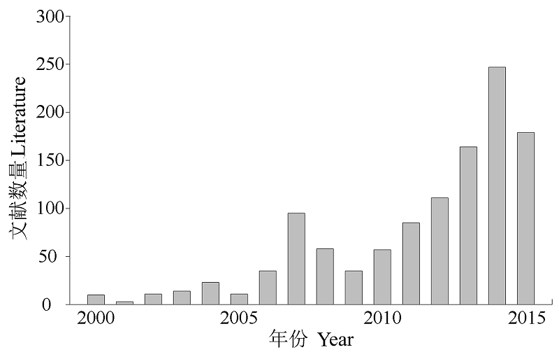
Fig. 1 The trend of literature quantity of UAV applied in ecological environment
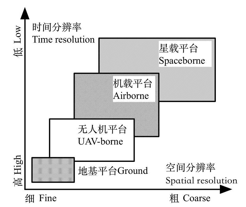
Fig. 2 The scale of UAV applied in biodiversity remote sensing monitoring
| 微型无人机 Mini UAV | 轻型无人机 Light UAV | 小型无人机 Small UAV | 大型无人机 Large UAV | |
|---|---|---|---|---|
| 空机重量 Weight (kg) | < 7 | 7-116 | ≤ 5,700 | > 5,700 |
| 载荷大小 Payload (kg) | < 5 | 5-30 | ≤ 50 | 200-900 |
| 续航时间 Flying time (h) | < 1 | < 2 | < 10 | < 48 |
| 最大飞行高度 Max ?ying height (km) | < 0.25 | < 1 | < 4 | 3-20 |
Table 1 Comparison the characterization of different UAV sizes (refer to the Interim Provisions on the Administration of Civil Unmanned Aircraft System Pilot; Anderson & Gaston, 2013)
| 微型无人机 Mini UAV | 轻型无人机 Light UAV | 小型无人机 Small UAV | 大型无人机 Large UAV | |
|---|---|---|---|---|
| 空机重量 Weight (kg) | < 7 | 7-116 | ≤ 5,700 | > 5,700 |
| 载荷大小 Payload (kg) | < 5 | 5-30 | ≤ 50 | 200-900 |
| 续航时间 Flying time (h) | < 1 | < 2 | < 10 | < 48 |
| 最大飞行高度 Max ?ying height (km) | < 0.25 | < 1 | < 4 | 3-20 |
| 固定翼 Fixed-wing | 多旋翼 Rotating-wing | |
|---|---|---|
| 优势 Advantage | 飞行速度快、航程远、航时长、载荷大、空中最大飞行高度更高 Faster in flying speed, longer in flying time and distance, larger in payload, and higher in max ?ying height | 起飞环境要求低, 不受场地限制; 能悬停, 可长时间观测某个静止目标; 操作简单、维护方便 Less requirements in takeoff and landing place, hover in place and observe, and easy to operate and maintain. |
| 局限性 Limitation | 操作相对困难, 受场地限制较多 More difficult in operation, and more requirements in takeoff and landing place | 载荷小、续航时间短 Lower in payload and shorter in flying time |
Table 2 Comparison of fixed- and rotating-wing UAV
| 固定翼 Fixed-wing | 多旋翼 Rotating-wing | |
|---|---|---|
| 优势 Advantage | 飞行速度快、航程远、航时长、载荷大、空中最大飞行高度更高 Faster in flying speed, longer in flying time and distance, larger in payload, and higher in max ?ying height | 起飞环境要求低, 不受场地限制; 能悬停, 可长时间观测某个静止目标; 操作简单、维护方便 Less requirements in takeoff and landing place, hover in place and observe, and easy to operate and maintain. |
| 局限性 Limitation | 操作相对困难, 受场地限制较多 More difficult in operation, and more requirements in takeoff and landing place | 载荷小、续航时间短 Lower in payload and shorter in flying time |
| 传感器 Sensor | 原始数据 Raw data | 应用案例 Application | 优势 Advantage | 局限性 Limitation |
|---|---|---|---|---|
| 高分相机 High-resolution camera | 二维图像, 包含颜色信息 2D image, RGB bands | 草地监测( Grassland monitoring ( | 价格便宜、数据处理技术相对成熟 Cheap in hardware and mature in data post-processing | 成像质量受天气条件影响; 光谱信息有限 The imaging quality is affected by the weather condition, and limited in spectral information |
| 多光谱成像仪 Multi spectrum sensor | 二维图像, 包含几个离散波段的光谱信息 2D image, several spectral bands | 冠层截获的光合有效辐射研究( Photosynthetically available radiation interception in canopy ( | 能够获取光谱信息, 反演常用植被指数 Easy to retrieval vegetation index | 同物异谱、同谱异物现象造成数据解译困难 Difficult in classification due to synonyms spectrum phenomenon and same spectrum different object phenomenon |
| 高光谱 成像仪 Hyperspectral sensor | 二维图像, 能够获取近百个波段的光谱信息 2D image, hundred spectral bands | 病虫害监测( 冠层生化参数反演( Pest monitoring ( Deriving canopy biochemical parameter | 光谱分辨率高, 有利于精确反演各种生化参数 Higher in spectral resolution, easier to the precise derive biochemical parameters | 数据量大, 数据处理分析难度大 Large in data size and difficult in data processes and analysis |
| 热红外 相机 Thermal infrared sensor | 二维图像, 包含温度信息 2D image, contains temperature information | 干旱胁迫响应研究( , 2011 Plant response to drought ( | 能够获取温度信息, 可以识别部分动物 Obtain temperature information and detect some animals | 温度变化易受周围环境影响 Affected by the environment temperature |
| 激光雷达 扫描仪 LiDAR sensor | 点云数据, 包含三维地理坐标 Point cloud, with 3D geographic coordinates | 森林参数提取( Forest parameters extraction ( | 高精度, 受外界环境因素影响小; 可反演植被三维形态结构参数。 High precision, rarely influenced by the external environment; able to retrieve three dimensional shape and structure parameters of vegetation | 无法获取纹理、光谱信息 Unable to obtain texture and spectral information |
Table 3 Advantages and limitation of different sensors and the application
| 传感器 Sensor | 原始数据 Raw data | 应用案例 Application | 优势 Advantage | 局限性 Limitation |
|---|---|---|---|---|
| 高分相机 High-resolution camera | 二维图像, 包含颜色信息 2D image, RGB bands | 草地监测( Grassland monitoring ( | 价格便宜、数据处理技术相对成熟 Cheap in hardware and mature in data post-processing | 成像质量受天气条件影响; 光谱信息有限 The imaging quality is affected by the weather condition, and limited in spectral information |
| 多光谱成像仪 Multi spectrum sensor | 二维图像, 包含几个离散波段的光谱信息 2D image, several spectral bands | 冠层截获的光合有效辐射研究( Photosynthetically available radiation interception in canopy ( | 能够获取光谱信息, 反演常用植被指数 Easy to retrieval vegetation index | 同物异谱、同谱异物现象造成数据解译困难 Difficult in classification due to synonyms spectrum phenomenon and same spectrum different object phenomenon |
| 高光谱 成像仪 Hyperspectral sensor | 二维图像, 能够获取近百个波段的光谱信息 2D image, hundred spectral bands | 病虫害监测( 冠层生化参数反演( Pest monitoring ( Deriving canopy biochemical parameter | 光谱分辨率高, 有利于精确反演各种生化参数 Higher in spectral resolution, easier to the precise derive biochemical parameters | 数据量大, 数据处理分析难度大 Large in data size and difficult in data processes and analysis |
| 热红外 相机 Thermal infrared sensor | 二维图像, 包含温度信息 2D image, contains temperature information | 干旱胁迫响应研究( , 2011 Plant response to drought ( | 能够获取温度信息, 可以识别部分动物 Obtain temperature information and detect some animals | 温度变化易受周围环境影响 Affected by the environment temperature |
| 激光雷达 扫描仪 LiDAR sensor | 点云数据, 包含三维地理坐标 Point cloud, with 3D geographic coordinates | 森林参数提取( Forest parameters extraction ( | 高精度, 受外界环境因素影响小; 可反演植被三维形态结构参数。 High precision, rarely influenced by the external environment; able to retrieve three dimensional shape and structure parameters of vegetation | 无法获取纹理、光谱信息 Unable to obtain texture and spectral information |
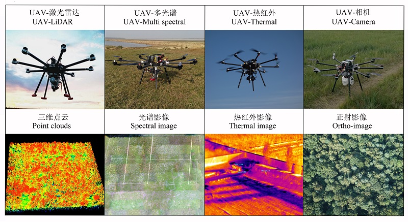
Fig. 3 Different UAV-RS platforms and its corresponding data
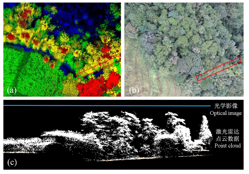
Fig. 4 Comparison of LiDAR point cloud data and traditional optical image. (a) UAV LiDAR data; (b) UAV optical image data; (c) Point cloud profile.
| 54 | Zhang M, Mi XC, Jin GZ (2014) Composition and spatial patterns of the Liangshui spruce-fir valley forest in the Xiao |
| 55 | Hinggan Mountains.Chinese Science Bulletin, 59, 2377-2387. (in Chinese with English abstract) |
| [张觅, 米湘成, 金光泽 (2014) 小兴安岭凉水谷地云冷杉林群落组成与空间格局. 科学通报, 59, 2377-2387.] | |
| 56 | Zhang Y, Tao P, Liang SX, Liang WL (2011) Research on application of UAV RS techniques in forest inventories. Journal of Southwest Forestry University, 31(3), 49-53. (in Chinese with English abstract) |
| [张园, 陶萍, 梁世祥, 梁万里(2011) 无人机遥感在森林资源调查中的应用. 西南林学院学报, 31(3), 49-53.] | |
| 57 | Zhao CH, Yang WB, Li B, Yang G (2014) Composite aircraft with fixed wing and four-rotor-wing combined. In: Proceedings of the Fifth China Unmanned Aerial Vehicle (UAV) Conference (eds Chinese Aeronautical Society), pp. 39-44. China Aviation Publishing Media Co., Ltd, Beijing. (in Chinese) |
| [赵长辉, 杨五兵, 李波, 杨光 (2014)固定翼四旋翼复合飞行器. (第五届)中国无人机大会论文集(主编: 中国航空学会), 39-44. 中航出版传媒有限责任公司, 北京.] | |
| 58 | Zhao X, Xu LN, Jin GZ (2015) Effect of topography on shrub regeneration in a mixed broadleaved-Korean pine forest in the Xiaoxing’an Mountains. Biodiversity Science, 23, 767-774. |
| (in Chinese with English abstract) [赵雪, 徐丽娜, 金光泽 (2015) 地形对典型阔叶红松林灌木更新的影响. 生物多样性, 23, 767-774.] | |
| 1 | Anderson K, Gaston KJ (2013) Lightweight unmanned aerial vehicles will revolutionize spatial ecology. Frontiers in Ecology and the Environment, 11, 138-146. |
| 2 | Bareth G, Bolten A, Hollberg J, Aasen H, Burkart A, Schellberg J (2015) Feasibility study of using non-calibrated UAV-based RGB imagery for grassland monitoring: case study at the Rengen Long-term Grassland Experiment (RGE), Germany. DGPF Tagungsband, 24, 1-7. |
| 3 | Bellvert J, Zarco-Tejada PJ, Girona J, Fereres E (2014) Mapping crop water stress index in a ‘Pinot-noir’ vineyard: comparing ground measurements with thermal remote sensing imagery from an unmanned aerial vehicle. Precision Agriculture, 15, 361-376. |
| 4 | Bendig J, Bolten A, Bareth G (2012) Introducing a low-cost mini-UAV for thermal-and multispectral-imaging. International Archives of the Photogrammetry, Remote Sensing and Spatial Information Sciences, 39, 345-349. |
| 5 | Butchart SHM, Walpole M, Collen B, Strien A, Scharlemann JPW, Almond REA, Baillie JEM, Bomhard B, Brown C, Bruno J, Carpenter KE, Carr GM, Chanson J, Chenery AM, Csirke J, Davidson NC, Dentener F, Foster M, Galli A, Galloway JN, Genovesi P, Gregory RD, Hockings M, Kapos V, Lamarque JF, Leverington F, Loh J, McGeoch MA, McRae L, Minasyan A, Morcillo MH, Oldfield TEE, Pauly D, Quader S, Revenga C, Sauer JR, Skolnik B, Spear D, Stanwell-Smith D, Stuart SN, Symes A, Tierney M, Tyrrell TD, Vié JC, Watson R (2010) Global biodiversity: indicators of recent declines. Science, 328, 1164-1168. |
| 6 | Colomina I, Molina P (2014) Unmanned aerial systems for photogrammetry and remote sensing: a review. ISPRS Journal of Photogrammetry and Remote Sensing, 92, 79-97. |
| 7 | Davies AB, Asner GP (2014) Advances in animal ecology from 3D-LiDAR ecosystem mapping. Trends in Ecology & Evolution, 29, 681-691. |
| 8 | De Biasio M, Arnold T, Leitner R (2011) UAV based multi-spectral imaging system for environmental monitoring. tm-Technisches Messen Plattform für Methoden, Systeme und Anwendungen der Messtechnik, 78, 503-507. |
| 9 | Feng JL, Liu K, Zhu YH, Li Y, Liu L, Meng L (2015) Application of unmanned aerial vehicles to mangrove resources monitoring. Tropical Geography, 35(1), 35-42. (in Chinese with English abstract) |
| [冯家莉, 刘凯, 朱远辉, 李勇, 柳林, 蒙琳 (2015) 无人机遥感在红树林资源调查中的应用. 热带地理, 35, 35-42.] | |
| 10 | Franklin J (1995) Predictive vegetation mapping: geographic modelling of biospatial patterns in relation to environmental gradients. Progress in Physical Geography, 19, 474-499. |
| 11 | Franklin J, Davis FW, Ikegami M, Syphard AD, Flint LE, Flint AL, Hannah L (2013) Modeling plant species distributions under future climates: how fine scale do climate projections need to be? Global Change Biology, 19, 473-483. |
| 12 | Fu BJ, Niu D, Yu GR (2007) The roles of ecosystem observation and research network in earth system science. Progress in Geography, 26, 1-16. (in Chinese with English abstract) |
| [傅伯杰, 牛栋, 于贵瑞 (2007) 生态系统观测研究网络在地球系统科学中的作用. 地理科学进展, 26(1), 1-16.] | |
| 13 | Getzin S, Wiegand K, Schöning I (2012) Assessing biodiversity in forests using very high-resolution images and unmanned aerial vehicles. Methods in Ecology and Evolution, 3, 397-404. |
| 14 | Gini R, Passoni D, Pinto L, Sona G (2014) Use of unmanned aerial systems for multispectral survey and tree classification: a test in a park area of northern Italy. European Journal of Remote Sensing, 47, 251-269. |
| 15 | Gonzalez LF, Montes GA, Puig E, Johnson S, Mengersen K, Gaston KJ (2016) Unmanned Aerial Vehicles (UAVs) and Artificial Intelligence Revolutionizing Wildlife Monitoring and Conservation. Sensors, 16, 1-18. |
| 16 | Guillen-Climent ML, Zarco-Tejada PJ, Berni JAJ, North PRJ, Villalobos FJ (2012) Mapping radiation interception in row-structured orchards using 3D simulation and high-resolution airborne imagery acquired from a UAV. Precision Agriculture, 13, 473-500. |
| 17 | Guo QH, Liu J, Li YM, Zhai QP, Wang YC, Wu FF, Hu TY, Wan HW, Liu HM, Shen WM (2016) A near-surface remote sensing platform for biodiversity monitoring: perspectives and prospects. Biodiversity Science, 24, 1249-1266. (in Chinese with English abstract) |
| [郭庆华, 刘瑾, 李玉美, 翟秋萍, 王永财, 吴芳芳, 胡天宇, 万华伟, 刘慧明, 申文明 (2016) 生物多样性近地面遥感监测: 应用现状与前景展望. 生物多样性, 24, 1249-1266.] | |
| 18 | Guo QH, Liu J, Tao SL, Xue BL, Li L, Xu GC, Li WK, Wu FF, Li YM, Chen LH, Pang SX (2014) Perspectives and prospects of LiDAR in forest ecosystem monitoring and modeling. Chinese Science Bulletin, 59, 459-478. (in Chinese with English abstract) |
| [郭庆华, 刘瑾, 陶胜利, 薛宝林, 李乐, 徐光彩, 李文楷, 吴芳芳, 李玉美, 陈琳海, 庞树鑫 (2014) 激光雷达在森林生态系统监测模拟中的应用现状与展望, 科学通报, 59, 459-478.] | |
| 19 | Hao ZQ, Li BH, Zhang J, Wang XG, Ye J, Yao XL (2008) Broad-leaved Korean pine (Pinus koraiensis) mixed forest plot in Changbaishan (CBS) of China: community composition and structure. Chinese Journal of Plant Ecology, 32, 238-250. (in Chinese with English abstract) |
| [郝占庆, 李步杭, 张健, 王绪高, 叶吉, 姚晓琳 (2008) 长白山阔叶红松林样地 (CBS): 群落组成与结构. 植物生态学报, 32, 238-250.] | |
| 20 | Hodgson JC, Koh LP (2016) Best practice for minimising unmanned aerial vehicle disturbance to wildlife in biological field research. Current Biology, 26, 404-405. |
| 21 | Holmgren J, Persson Å (2004) Identifying species of individual trees using airborne laser scanner. Remote Sensing of Environment, 90, 415-423. |
| 22 | Huang S, Crabtree RL, Potter C, Gross P (2009) Estimating the quantity and quality of coarse woody debris in Yellowstone post-fire forest ecosystem from fusion of SAR and optical data. Remote Sensing of Environment, 113, 1926-1938. |
| 23 | Hyyppä J, Hyyppä H, Inkinen M, Engdahl M, Linko S, Zhu YH (2000) Accuracy comparison of various remote sensing data sources in the retrieval of forest stand attributes. Forest Ecology and Management, 128, 109-120. |
| 24 | Israel M (2011) A UAV-based roe deer fawn detection system. International Archives of Photogrammetry and Remote Sensing, 38, 1-5. |
| 25 | Jones IV GP, Pearlstine LG, Percival HF (2006) An assessment of small unmanned aerial vehicles for wildlife research. Wildlife Society Bulletin, 34, 750-758. |
| 26 | Jörg M, Roland B (2009) Assessing biodiversity by remote sensing in mountainous terrain: the potential of LiDAR to predict forest beetle assemblages. Journal of Applied Ecology, 46, 897-905. |
| 27 | Kaneko K, Nohara S (2014) Review of effective vegetation mapping using the UAV (Unmanned Aerial Vehicle) method. Journal of Geographic Information System, 6, 733-742. |
| 28 | Kayitakire F, Hamel C, Defourny P (2006) Retriving forest structure variables based on image texture analysis and IKONOS-2 imagery. Remote Sensing of Environment, 102, 390-401. |
| 29 | Kelly M, Tuxen KA, Stralberg D (2011) Mapping changes to vegetation pattern in a restoring wetland: finding pattern metrics that are consistent across spatial scale and time. Ecological Indicators, 11, 263-273. |
| 30 | Koh LP, Wich SA (2012) Dawn of drone ecology: low-cost autonomous aerial vehicles for conservation. Conservation Letters, 5, 121-132. |
| 31 | Li DR, Li M (2014) Research advance and application prospect of unmanned aerial vehicle remote sensing system. Geomatics and Information Science of Wuhan University, 39, 505-513. (in Chinese with English abstract) |
| [李德仁, 李明 (2014) 无人机遥感系统的研究进展与应用前景. 武汉大学学报(信息科学版), 39, 505-513.] | |
| 32 | Li ZC, Ma MG, Zhang F, Jiang ZR (2006) The dynamic analysis of vegetation pattern in the northwest of China. Remote Sensing Technology and Application, 21, 332-337. (in Chinese with English abstract) |
| [李珍存, 马明国, 张峰, 蒋志荣 (2006) 1982-2003年中国西北地区植被动态变化格局分析. 遥感技术与应用, 21, 332-337.] | |
| 33 | Lu XC, Guo QH, Li WK, Flanagan J (2014) A bottom-up approach to segment individual deciduous trees using leaf-off lidar point cloud data. ISPRS Journal of Photogrammetry and Remote Sensing, 94, 1-12. |
| 34 | Ma KP (1993) On the concept of biodiversity. Biodiversity Science, 1, 20-22. (in Chinese) |
| [马克平 (1993) 试论生物多样性的概念. 生物多样性, 1, 20-22.] | |
| 35 | Ma KP (2015) Biodiversity monitoring in China: from CForBio to Sino BON. Biodiversity Science, 23, 1-2. |
| [马克平 (2015) 中国生物多样性监测网络建设: 从CForBio到Sino BON. 生物多样性, 23, 1-2.] | |
| 36 | Mancini F, Dubbini M, Gattelli M, Stecchi F, Fabbri S, Gabbianelli G (2013) Using Unmanned Aerial Vehicles (UAV) for high-resolution reconstruction of topography: the structure from motion approach on coastal environments. Remote Sensing, 5, 6880-6898. |
| 37 | McDowell NG, Coops NC, Beck PSA, Chambers JQ, Gangodagamage C, Hicke JA, Huang C, Kennedy R, Krofcheck DJ, Litvak M, Meddens AJH, Muss J, Negrón-Juarez R, Peng CH, Schwantes AM, Swenson JJ, Vernon LJ, Williams AP, Xu CG, Zhao MS, Running SW, Allen CD (2015) Global satellite monitoring of climate-induced vegetation disturbances. Trends in Plant Science, 20, 114-123. |
| 38 | Merino L, Caballero F, Martinez R, Maza I, Ollero A (2010) Automatic forest fire monitoring and measurement using unmanned aerial vehicles. In: VI International Conference on Forest Fire Research (ed. Viegas DX), pp. 1-15. |
| 39 | Näsi R, Honkavaara E, Lyytikäinen-Saarenmaa P, Blomqvist M, Litkey P, Hakala T, Viljanen N, Kantola T, Tanhuanpää T, Holopainen M (2015) Using UAV-based photogra- mmetry and hyperspectral imaging for mapping bark beetle damage at tree-level. Remote Sensing, 7, 15467-15493. |
| 40 | Poiani KA, Richter BD, Anderson MG, Richter HE (2000) Biodiversity conservation at multiple scales: functional sites, landscapes, and networks. BioScience, 50, 133-146. |
| 41 | Popescu SC, Wynne RH (2004) Seeing the trees in the forest: using lidar and multispectral data fusion with local filtering and variable window size for estimating tree height. Photogrammetric Engineering and Remote Sensing, 70, 589-604. |
| 42 | Sandbrook C (2015) The social implications of using drones for biodiversity conservation. Ambio, 44, 636-647. |
| 43 | Souza-Filho PWM, Goncalves FD, Rodrigues SWP, Costa FR, Miranda FP (2009) Multi-sensor data fusion for geomorphological and environmental sensitivity index mapping in the Amazonian mangrove coast, Brazil. Journal of Coastal Research, SI56, 1592-1596. |
| 44 | Stephenson PJ, Burgess ND, Jungmann L, Loh J, O’Connor S, Oldfield T, Reidhead W, Shapiro A (2015) Overcoming the challenges to conservation monitoring: integrating data from in-situ reporting and global data sets to measure impact and performance. Biodiversity, 16, 68-85. |
| 45 | Tattoni C, Rizzolli F, Pedrini P (2012) Can LiDAR data improve bird habitat suitability models? Ecological Modelling, 245, 103-110. |
| 46 | Wallace L, Lucieer A, Watson C (2012a) Assessing the feasibility of UAV-based LiDAR for high resolution forest change detection. International Archives of the Photogrammetry, Remote Sensing and Spatial Information Sciences, 499-504. |
| 47 | Wan H, Wang Q, Jiang D, Fu J, Yang Y, Liu X (2014) Monitoring the invasion of Spartina alterniflora using very high resolution unmanned aerial vehicle imagery in Beihai, Guangxi (China). The Scientific World Journal, 2014, 1-8. |
| 48 | Watts, AC, Ambrosia VG, Hinkley EA (2012) Unmanned aircraft systems in remote sensing and scientific research: classification and considerations of use. Remote Sensing, 4, 1671-1692. |
| 49 | Wilson JW, Sexton JO, Jobe RT, Haddad NM (2013) The relative contribution of terrain, land cover, and vegetation structure indices to species distribution models. Biological Conservation, 164, 170-176. |
| 50 | Xu WT, Wu BF (2005) Progress on measuring forest biodiversity with remote sensing technique. Acta Ecologica Sinica, 25, 1199-1204. (in Chinese with English abstract) |
| [徐文婷, 吴炳方 (2005) 遥感用于森林生物多样性监测的进展. 生态学报, 25, 1199-1204.] | |
| 51 | Xu ZQ, Cao L, Ruan HH, Li WZ, Jiang S (2015) Inversion of subtropical forest stand characteristics by integrating very high resolution imagery acquired from UAV and LiDAR point-cloud. Chinese Journal of Plant Ecology, 39(7), 694-703. (in Chinese with English abstract) |
| [许子乾, 曹林, 阮宏华, 李卫正, 蒋圣 (2015) 集成高分辨率 UAV 影像与激光雷达点云的亚热带森林林分特征反演. 植物生态学报, 39(7), 694-703.] | |
| 52 | Zarco-Tejada PJ, Guillén-Climent M, Hernández-Clemente R, Catalina A, González M, Martín P (2013) Estimating leaf carotenoid content in vineyards using high resolution hyperspectral imagery acquired from an unmanned aerial vehicle (UAV). Agricultural and Forest Meteorology, 171, 281-294. |
| 53 | Zhang CY, Zhao XH, Zhao YZ (2009) Community structure in different successional stages in north temperate forests of Changbai Mountains, China. Chinese Journal of Plant Ecology, 33, 1090-1100. (in Chinese with English abstract) |
| [张春雨, 赵秀海, 赵亚洲 (2009) 长白山温带森林不同演替阶段群落结构特征. 植物生态学报, 33, 1090-1100.] |
| [1] | Zitong Bai, Cheng Wang, Zhiyong Qi. Biophony responses to different vegetation structure in urban central parks of Beijing [J]. Biodiv Sci, 2026, 34(4): 25218-. |
| [2] | Xixia Lu, Fengxiang Zhou, Liming Yong, Qianhui Zeng, Liyuan Zhao, Yuke Zhang, Xianyan Wang. Impacts of coastal reclamation on Chinese white dolphin (Sousa chinensis) habitats in China from 1990 to 2020 [J]. Biodiv Sci, 2026, 34(3): 25249-. |
| [3] | Chunying Wu, Viorel D. Popescu, Yinqiu Ji. Hierarchical occupancy models as solutions to challenges in biodiversity assessment [J]. Biodiv Sci, 2026, 34(1): 25386-. |
| [4] | Lu Xiaoqiang, Dong Shanshan, Ma Yue, Xu Xu, Qiu Feng, Zang Mingyue, Wan Yaqiong, Li Luanxin, Yu Cigang, Liu Yan. Current status, challenges, and prospects of frontier technologies in biodiversity conservation applications [J]. Biodiv Sci, 2025, 33(4): 24440-. |
| [5] | Yuan Jingyi, Zhang Xu, Tian Zhenpeng, Wang Zizhe, Gao Yongping, Yao Dizhao, Guan Hongcan, Li Wenkai, Liu Jing, Zhang Hong, Ma Qin. A comparison of methods for extracting tree species composition and quantitative characteristics in urban plant communities using UAV high-resolution RGB imagery and LiDAR point cloud [J]. Biodiv Sci, 2025, 33(4): 24237-. |
| [6] | Xie Gan, Xuan Jing, Fu Qidi, Wei Ze, Xue Kai, Luo Hairui, Gao Jixi, Li Min. Establishing an intelligent identification model for unmanned aerial vehicle surveys of grassland plant diversity [J]. Biodiv Sci, 2025, 33(4): 24236-. |
| [7] | Liu Yonghua, Tong Guangrong, Yu Hangyuan, Wang Ningning, Ren Haibao, Chen Lei, Ma Keping, Mi Xiangcheng. Responses of canopy three-dimensional structural and spectral characteristics to anthropogenic disturbance in the Qianjiangyuan section of the Qianjiangyuan- Baishanzu National Park candidate area [J]. Biodiv Sci, 2025, 33(4): 24174-. |
| [8] | Wu Hui, Yu Le, Du Zhenrong, Zhao Qiang, Qi Wenchao, Cao Yue, Wang Jinzhou, Shen Xiaoli, Sun Yao, Ma Keping. Rapid assessment of the Kunming-Montreal Global Biodiversity Framework implementation progress based on remote sensing monitoring: Pathway and prospects [J]. Biodiv Sci, 2025, 33(3): 24526-. |
| [9] | Le Yu, Jiatong Gu, Hui Wu, Zhenrong Du, Xiyu Li, Xiaoli Shen, Li Zhu, Keping Ma. Biodiversity early warning for the objectives of Kunming-Montreal Global Biodiversity Framework [J]. Biodiv Sci, 2025, 33(12): 25329-. |
| [10] | Fengming Wan, Huawei Wan, Zhiru Zhang, Jixi Gao, Chenxi Sun, Yongcai Wang. The application potential of unmanned aerial vehicle surveys in grassland plant diversity [J]. Biodiv Sci, 2024, 32(3): 23381-. |
| [11] | Yufei Huang, Chunyan Lu, Mingming Jia, Zili Wang, Yue Su, Yanlin Su. Plant species classification of coastal wetlands based on UAV images and object- oriented deep learning [J]. Biodiv Sci, 2023, 31(3): 22411-. |
| [12] | Xin Yang, Zhiliang Yao, Bin Wang, Handong Wen, Yun Deng, Min Cao, Zhiming Zhang, Zhenghong Tan, Luxiang Lin. Driving effects of forest stand structure of a subtropical evergreen broad-leaved forest on species composition variation: From local to regional scales [J]. Biodiv Sci, 2023, 31(2): 22139-. |
| [13] | Jiesheng Rao, Tao Yang, Xi Tian, Wencong Liu, Xiaofeng Wang, Hengjun Qian, Zehao Shen. Vertical structural characteristics of a semi-humid evergreen broad-leaved forest and common tree species based on a portable backpack LiDAR [J]. Biodiv Sci, 2023, 31(11): 23216-. |
| [14] | Yu Ren, Shengli Tao, Tianyu Hu, Haitao Yang, Hongcan Guan, Yanjun Su, Kai Cheng, Mengxi Chen, Huawei Wan, Qinghua Guo. The outlook and system construction for monitoring Essential Biodiversity Variables based on remote sensing: The case of China [J]. Biodiv Sci, 2022, 30(10): 22530-. |
| [15] | Zhaochen Zhang, Jianbo Hu, Qingsong Yang, Juyu Lian, Buhang Li, Xihua Wang, Wanhui Ye, Jian Zhang. An unmanned aerial vehicle visible light remote sensing image dataset of four forest dynamic plots in subtropical China [J]. Biodiv Sci, 2021, 29(9): 1181-1185. |
| Viewed | ||||||
|
Full text |
|
|||||
|
Abstract |
|
|||||
Copyright © 2026 Biodiversity Science
Editorial Office of Biodiversity Science, 20 Nanxincun, Xiangshan, Beijing 100093, China
Tel: 010-62836137, 62836665 E-mail: biodiversity@ibcas.ac.cn