Please wait a minute...
Table of Content
    Volume 12 Issue 1
    20 January 2004
      
    Special Issue
    Exploring altitudinal patterns of plant diversity of China's mountains
    FANG Jing-Yun
    Biodiv Sci. 2004, 12 (1):  1-4.  doi:10.17520/biods.2004001
    Abstract ( 5130 )   PDF (163KB) ( 5059 )   Save
    Related Articles | Metrics
    The Protocol for the Survey Plan for Plant Species Diversity of China's Mountains
    FANG Jing-Yun, SHEN Ze-Hao, TANG Zhi-Yao, WANG Zhi-Heng
    Biodiv Sci. 2004, 12 (1):  5-9.  doi:10.17520/biods.2004002
    Abstract ( 6762 )   PDF (231KB) ( 6545 )   Save
    Related Articles | Metrics
    China is a mountainous country with rich biodiversity resources. To explore altitudinal patterns and geographic differentiation of plant species diversity in China′s mountains, Peking University has begun the Survey Plan for Plant Species Diversity of China′s Mountains (PKU-PSD Plan) since mid1990s. This paper presents the PKU-PSD Plan′s protocol, including the goals, research topics, mountain sites, and methodological standards for field surveys and data analysis.
    Ecological characteristics of mountains and research issues of mountain ecology
    FANG Jing-Yun, SHEN Ze-Hao, CUI Hai-Ting
    Biodiv Sci. 2004, 12 (1):  10-19.  doi:10.17520/biods.2004003
    Abstract ( 7770 )   PDF (341KB) ( 5976 )   Save
    Related Articles | Metrics
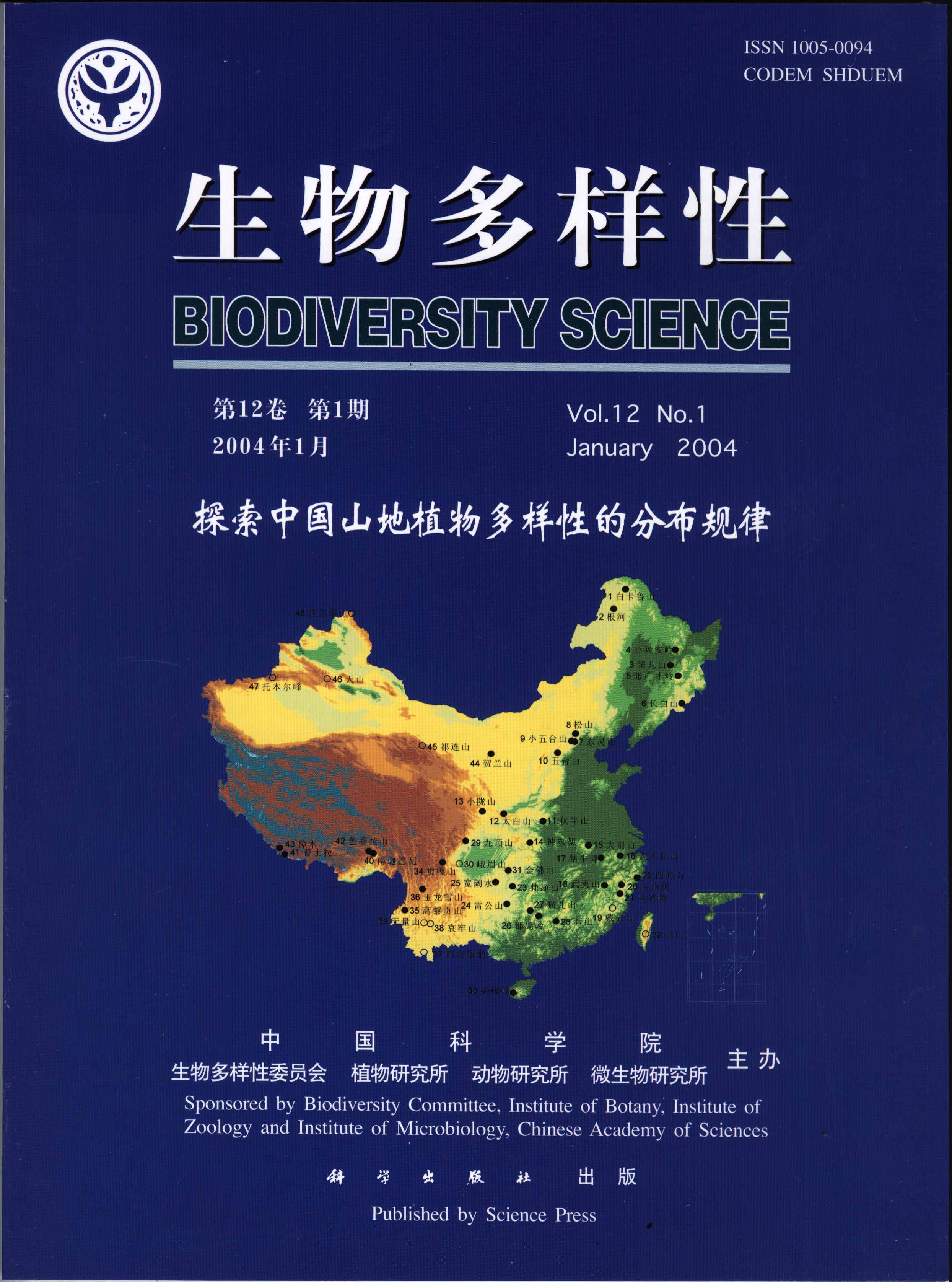
    Mountains are complex ecological systems, with unique structures and functions, and have rich biodiversity, water and mineral resources, and opportunities for tourism. Mountain ecology is the study of mountain structures, functions, and processes, as well as the exploration, sustainable utilization and conservation of mountain resources. In this paper, we review the effects of major topographic elements on ecological factors, summarize the ecological benefits of mountains, and discuss the current research issues and topics for Mountain Ecology. It is emphasized that in topography of mountainous areas is the most critical controlling factor for ecological structures, functions, and processes. Topography affects the abundance and distribution of organisms by modifying solar radiation, heat, moisture, soil and fertility. For this reason, topography and topographyinduced ecological phenomena and processes are considered to be the most critical topics in mountain ecology. Topographic research addresses such issues as ecological complexity, biodiversity, mountain climate changes, mountain ecological engineering, mountain sustainable development, and quantification of topographic elements (elevation, slope, aspect, and location). Among these, developing appropriate methods for quantifying topographic elements is a key technique. We also suggest a need for a synthetic study of relationships between humans and the natural world based mountain sustainable development.
    A review on the elevational patterns of plant species diversity
    TANG Zhi-Yao, FANG Jing-Yun
    Biodiv Sci. 2004, 12 (1):  20-28.  doi:10.17520/biods.2004004
    Abstract ( 6217 )   PDF (358KB) ( 7461 )   Save
    Related Articles | Metrics
    Patterns of biodiversity along environmental gradients is one of the basic issues in the biodiversity studies. The elevational gradient incorporates multiple resource gradients which vary continuously in different fashions. As patterns along environmental gradients are significantly scaledependent, we reviewed plant diversity patterns along the elevational gradient in different scales: α diversity, β diversity and γ diversity, as well the factors which maintain these patterns. At the local scale, there is no fixed elevational pattern for herb species richness. For woody plants, the monotonic decrease of species richness as elevation increases is thought to be a general pattern, yet other patterns exist. The decrease of β diversity with increasing elevation has been observed in different ecosystems. Species richness in different elevational bands exhibits two different patterns, monotonic decrease and humpshaped pattern along the elevational gradient.
    Community structures and species richness in the montane rain forest of Jianfengling, Hainan Island, China
    FANG Jing-Yun, LI Yi-De, ZHU Biao, LIU Guo-Hua, ZHOU Guang-Yi
    Biodiv Sci. 2004, 12 (1):  29-43.  doi:10.17520/biods.2004005
    Abstract ( 4354 )   PDF (596KB) ( 4198 )   Save
    Related Articles | Metrics
    Mt. Jianfengling, located in southwestern Hainan Island, is one of few areas in China where there exist wellprotected primary forest types resembling tropical rainforest. An 1 hm2 of permanent plot was established in a mountain rainforest and all trees with DBH≥5.0 cm were measured to study community structures and species richness of the forest type. A total of 171 species belonging to 93 genera and 52 families were identified, and a total of 1099 individuals were recorded, of which 1024 were trees. Diversity indices measured as ShannonWiener index (H′), evenness index (E) and Simpson index (D) were 4.11, 0.80 and 0.97 respectively. These indicies varied with sample size and initial DBH of measured individuals. H′, E and D clearly increased with increasing sample size, but exhibited no obvious pattern above 4000 m2 for H′ or 2000 m2 for E and D. As the initial DBH increased, numbers of species and families, as well as H′ and D decreased sharply, while E increased. DBH class frequency distribution revealed that number of individuals decreased with increasing DBH classes following an exponential function, and that community structure could be separated into four strata along an elevation gradient, with individuals distributed uniformly or randomly in each layer. The orientation of mountain rainforest of Jianfengling in the world rainforests is discussed from three aspects of climatology, family and genus composition, and comparison of species richness between rainforests of Jianfengling and other tropical regions. Climatological analysis indicated that the mountain rainforest of Jianfengling thermally corresponds to subtropical/warmtemperate zones and to arid/humid ranges of perhumid climate (rainforest climate). Floristically, subtropical/warm-temperate elements dominated, especially Fagaceae and Lauraceae (together accounting for more than 34% of the total importance value), while tropical elements were subordinate. Compared with the world tropical forests, species richness in the mountain rainforest in Jianfengling was lower than typical tropical rainforests but somewhat higher than tropical forests with low rainfall. Thus, the mountain rainforest of Jianfengling is much different with typical tropical rainforest and is a transitional forest type from tropical to subtropical/warmtemperate rainforests. In addition, two measures of species richness, mean population density (MPD) and number of speciesnumber of individuals relationship, are proposed and mathematically defined.
    Changes in floristic composition, community structure, and tree species diversity of plant communities along altitudinal gradients on Mt. Mao'er, Guangxi, China
    ZHU Biao, CHEN An-Ping, LIU Zeng-Li, LI Guang-Zhao, FANG Jing-Yun
    Biodiv Sci. 2004, 12 (1):  44-52.  doi:10.17520/biods.2004006
    Abstract ( 3905 )   PDF (408KB) ( 3617 )   Save
    Related Articles | Metrics
    We analyzed changes in species diversity of plant communities on Mt. Mao'er using data from 16 plots, which were investigated along an altitudinal gradient at 100 m intervals. Each tree (DBH>3.3cm) was identified and recorded. Major results were summarized as follows: (1) A total of 184 tree species from 79 genera in 44 families, among which 121 were evergreen broadleaved, 61 were deciduous broadleaved and 2 were coniferous, were recorded. (2) Maximum height of tree layer and of different life forms decreased significantly with increasing altitude; however, maximum DBH, basal area and stem density were highest at midaltitudes. (3) Species richness did not change greatly below 1350 m but decreased sharply with an increasing altitude, with a peak at 1350 m. (4) Alpha diversity correlated with altitude in a similar but less significant fashion compared with species richness. Diversity (H′) correlated negatively with altitude, while evenness (E) did not change notably with altitude. (5) Similarity (CJ) between neighboring plots below 1350 m was larger than that above 1350 m, and the minimum similarity occurred in the transitional zone between different vegetation types. Species turnover (Cody index) paralleled patterns of community similarity (CJ). (6) In the study region, altitude seemed to be the primary determinant of community structure, species richness and alpha diversity, rather than slope and aspect. Spatial heterogeneity resulting from human disturbance and microlandform appeared to determine these characteristics at a local scale.
    Plant community composition and tree species diversity on eastern and western Nanling Mountains, China
    ZHU Biao, CHEN An-Ping, LIU Zeng-Li, FANG Jing-Yun
    Biodiv Sci. 2004, 12 (1):  53-62.  doi:10.17520/biods.2004007
    Abstract ( 4220 )   PDF (421KB) ( 3663 )   Save
    Related Articles | Metrics
    We studied changes in floristic composition, community structure and tree species diversity along an altitudinal gradient on Mt. Mang (eastern Nanling Mountains) and Mt. Mao′er (western Nanling Mountains). Floristic composition, but not vegetation type, differed greatly between these two mountains. Maximum tree height decreased sharply with increasing altitude on both mountains. On Mt. Mao′er, maximum DBH, basal area and stem density peaked at intermediate elevations. On Mt. Mang, maximum DBH and basal area showed significantly negative correlations with altitude while stem density did not change significantly with altitude. These unimodal patterns or negative relationships of DBH, basal area and stem density might result from altitudinal gradient at the meso-scale and soil properties, microtopography, and human disturbances at the small scale. Tree species richness on Mt. Mang was obviously higher than that of Mt. Mao′er in the evergreen broad-leaved forests below 1000 m and in brushwoods above 1700 m. On both mountains, species number correlated negatively with altitude, however, this trend was insignificant on Mt. Mang due mainly to human activities at high altitudes. Alpha diversity of tree layer kept stable with increasing altitude and did not differ significantly between these two mountains. Considering tree species composition and diversity of evergreen broad-leaved forests on these two mountains, species richness (S) and α diversity (H′) of the evergreen broad-leaved forests of Mt. Mao′er were lower than those of Mt. Mang. This might stem from human activity and the invasion of many deciduous broad-leaved species and bamboo (Phyllostachys pubescens) on Mt. Mao′er.
    Tree species diversity along altitudinal gradient on southeastern and northwestern slopes of Mt. Huanggang, Wuyi Mountains, Fujian, China
    ZHENG Cheng-Yang, LIU Zeng-Li, FANG Jing-Yun
    Biodiv Sci. 2004, 12 (1):  63-74.  doi:10.17520/biods.2004008
    Abstract ( 4349 )   PDF (454KB) ( 4734 )   Save
    Related Articles | Metrics
    To investigate altitudinal changes of tree species biodiversity and community structures, we investigated 30 plots on the southeastern slope and 13 plots on the northwestern slope of Mt. Huanggang, Wuyi Mountains, Fujian Province. We recorded 151 tree species from 42 families and 73 genera on the southeastern slope, and 102 tree species from 32 families and 54 genera on the northwestern slope. There was no significant difference of tree species composition between these two slopes. The number of families, genera and species in the tree layer decreased as altitude increased. The richest families, genera and species were recorded at the altitudes between 800-1000 m a.s.l. on the southeastern slope, and between 1500-1600 m a.s.l. on the northwestern slope. The species diversity of tree layer on the northwestern slope was higher than that of the southeastern slope from 1200-1800m a.s.l.. ShannonWiener index (H′) correlated negatively with elevation on both slopes. Srenson index (IAc) varied in transitional zones between vegetation types, and was lowest at the ecotone between evergreen broadleaved forests and mixed coniferous and broadleaved forests. Considering community structures, larger maximum tree height (Hmax) and maximum diameter of breast height (DBHmax) were recorded at middle elevations than at upper or lower elevations. Hmax and DBHmax were higher on the northwestern slope than on the southeastern slope at the same elevations. Total basal area (TBA) of evergreen broadleaved trees was greater than those of deciduous broadleaved trees and coniferous trees at low elevations. TBA of coniferous trees showed two peaks, corresponding to two different types of coniferous species while that of deciduous broadleaved species stayed stable along the altitudinal gradient. TBA of deciduous broadleaved trees was greater on the northwestern slope than on the southeastern slope. TBA patterns of these three life forms along the altitudinal gradient were similar on both slopes.
    Effects of topographical factors on distribution of Phyllostachys pubescensin Wuyishan Nature Reserve, Fujian Province, China
    ZHENG Cheng-Yang, FANG Jing-Yun, He Jian-Yuan
    Biodiv Sci. 2004, 12 (1):  75-81.  doi:10.17520/biods.2004009
    Abstract ( 4218 )   PDF (381KB) ( 3776 )   Save
    Related Articles | Metrics
    Based on 31 sample plots, 9 community types of bamboo (Phyllostachys pubescens) forest from Wuyishan Nature Reserve, Fujian Province, were identified by cluster analysis in PC-ORD 4.0. The distribution of these 9 types was mapped based on the distribution map derived from aerial photos (1980) and two sets of Landsat TM (Thematic Map) images (1998, 2000) integrated with the data of the forest inventory in the whole reserve. Topographic features such as altitude, slope and aspect were derived from a Digital Elevation Model (DEM) created by digitizing the contour map in 100 m intervals (1:50 000). These features were then applied to spatial overlay analysis of bamboo distribution. The pure bamboo forest (40.6%) and Phyllostachys pubescens - Castanopsis eyrei bamboo forest (20.3%) were the two major types of bamboo forest in Wuyishan Nature Reserve. Maximum area of bamboo forest was recorded at the altitude of 500-700 m a.s.l. The proportion of bamboo forest within each altitudinal band declined with increasing altitude. ShannonWiener index (H′) of tree layer increased and diameter of breast height (DBH) decreased along the altitudinal gradient. The area of bamboo forests on the southeast and northwest slopes were larger than on other exposures. The area of bamboo forest decreased with the increasing slope.
    Pattern of species richness along an altitudinal gradient on Gaoligong Mountains, Southwest China
    WANG Zhi-Heng, CHEN An-Ping, PIAO Shi-Long, FANG Jing-Yun
    Biodiv Sci. 2004, 12 (1):  82-88.  doi:10.17520/biods.2004010
    Abstract ( 4435 )   PDF (261KB) ( 5865 )   Save
    Related Articles | Metrics
    Patterns of species richness along altitudinal gradients have become a focus of ecological research. We explored the patterns of seed plants richness along an altitudinal gradient on Gaoligong Mountains, Southwest China. Information on seed plants and their distribution ranges was collected from Flora of Gaoligong Mountains, and the DEM (Digital Elevation Model) was derived from a topographical map of this region. Using these datasets, altitudinal patterns of richness and species density of all seed plant species and plants of three different life forms (trees, shrubs and herbaceous plants), as well as their relationship with topographic parameters were studied. The results are summarized as follows: (1) the species richness increased rapidly first and then decreased with increasing elevation, peaking at the altitudes of between 1500 m and 2000 m; (2) similar to the altitudinal pattern of species richness, species, genus and family densities (number of taxa per unit area) also showed a humped pattern along the altitudinal gradient. Species density reached a maximum between 1500 m and 2000 m, with an average of 1653 m, while genus and family densities peaked between 900-1500 m, with an average of 1089 m,and (3) energy and moisture represented by elevation, as well as hard boundaries of species distribution were possible factors determining the patterns of species richness and density.
    Altitudinal pattern of flora on the eastern slope of Mt. Gongga
    SHEN Ze-Hao, LIU Zeng-Li, WU Jie
    Biodiv Sci. 2004, 12 (1):  89-98.  doi:10.17520/biods.2004011
    Abstract ( 4346 )   PDF (377KB) ( 4036 )   Save
    Related Articles | Metrics
    To explore the altitudinal differentiation of flora of Mt. Gongga and its relationship with those of surrounding areas, we investigated eight vertical vegetation zones on the eastern slope of Mt. Gongga, and analyzed the altitudinal distribution, the floristic components at the level of family, genus and species, and the contrast between different vegetation zones. Major results are as follows: (1) temperate flora primarily dominates the vegetation along the altitudinal gradient, but tropical and temperate components are equally abundant at the arid valley bottom area. The composition and altitudinal distribution of the tropical elements indicate the remnant effects of the Paleotropical and PaleoMediterranean flora; (2) East Asia and East Asia-North America arealtypes have the greatest influence on the forest flora in the middle part of Mt. Gongga, which are chiefly ancient temperate components; (3) North Temperate arealtype is the main body of the flora of Mt. Gongga, and comprises the bulk of the advanced and endemic components in the flora since the rise of the Tibet Plateau. It represents the young components of the flora, and (4) a wide range of Chinese endemic species comprise about 40%-65% of the flora of different vertical vegetation zones, increasing in dominance at higher elevations. At middle elevations, the flora of Mt. Gongga most closely relate to the flora of central China; at the alpine zone, the connection between Mt. Gongga and Tibet Plateau and East Himalayan Mountains takes precedence. The biogeographical significance of Gongga Mountain and the properties of the flora endemism at Mt. Gongga and Hengduan Mountain Range are discussed.
    Altitudinal patterns of plant species diversity on the southern slope of Mt. Shennongjia, Hubei, China
    SHEN Ze-Hao, HU Hui-Feng, ZHOU Yu, FANG Jing-Yun
    Biodiv Sci. 2004, 12 (1):  99-107.  doi:10.17520/biods.2004012
    Abstract ( 3768 )   PDF (473KB) ( 3878 )   English Version Save
    Related Articles | Metrics
    The southern slope of Mt. Shennongjia has long been viewed as an important boundary for China's vegetation regional division. In order to explore the altitudinal patterns of plant species diversity in this area, we sampled 50 plots along an altitudinal gradient on the southern slope. Species richness, intensity of flora differentiation, floristic composition and life forms were analyzed. Quantitative classification and DCA ordination were also applied to the sample plots. Major results were: (1) the vertical vegetation spectrum was evergreen broadleavee forest (below 900-1000 m a.s.l.), mixed deciduous and evergreen broadleaved forest (1000-1700 m), deciduous forest (1600-2100 m), mixed coniferous and deciduous forest (2000-2400 m), and subalpine coniferous forest (above 2300 m a.s.l.). (2) Evergreen and deciduous broadleaved tree species were almost equivalent in quantity and importance values in the basal vegetation zone. (3) The altitudinal pattern of plant species diversity showed a unimodal pattern, peaking at 1400-1500 m a.s.l. Mixed forest types have relatively higher α diversity and more intensive flora differentiation than the other types. (4) Temperate plants dominated the flora. With an increase of elevation, the number of cosmopolitan genera increased, while subtropical types and East Asian types decreased. Chinese endemic genera were limited to the area below 2000 m a.s.l. (5) Species richness of pteridophytes decreased with increasing elevation, while that of woody plants peaked in mixed evergreen and deciduous forest. Species richness of herbaceous did not correlate with elevation.
    Altitudinal patterns of plant species diversity in Mt. Niubeiliang, Qinling Mountains
    TANG Zhi-Yao, KE Jin-Hu
    Biodiv Sci. 2004, 12 (1):  108-114.  doi:10.17520/biods.2004013
    Abstract ( 3816 )   PDF (313KB) ( 3614 )   Save
    Related Articles | Metrics
    Using quantitative analysis (DCA and TWINSPAN), the vegetation and plant species diversity patterns along the elevation gradient in Mt. Niubeiliang, Qinling Mountains were studied based on 51 plots along two altitudinal transects between 1500 m and 2800 m on northern and southern slopes. Plant communities varied continuously along the elevation gradient. From low to high elevation, mountain oak forest, mountain birch forest, subalpine fir forests and subalpine shrub occurred on both slopes. Relationship between communities and topographic variables were analyzed by detrended correspondence analysis (DCA). Elevation was the primary determinant of floristic composition in Mt. Niubeiliang, and followed by exposure. In terms of species diversity, different patterns existed among total number of species, woody species richness and herbaceous species richness, and also between southern and northern slopes. The total number of species changed unimodally with elevation on the southern slope, peaking at middle elevations. No significant relationship between total number of species and elevation was detected on the northern slope. Woody species richness changed similarly on both southern and northern slopes, keeping stable at low elevations and decreasing monotonically with the increasing elevation at high elevations. In contrast, no significant pattern of herbaceous plant richness existed along the elevation gradient. β diversity was higher at lower and higher elevations than in the mid-altitudinal zone, indicating a more homogeneous habitat at middle elevation than upper and lower elevations. Human disturbance at lower elevation and the timberline ecotone at higher elevations may contribute to the increase of β diversity in these areas.
    Patterns of woody plant species diversity along environmental gradients on Mt. Taibai, Qinling Mountains
    TANG Zhi-Yao, FANG Jing-Yun, ZHANG Ling
    Biodiv Sci. 2004, 12 (1):  115-122.  doi:10.17520/biods.2004014
    Abstract ( 3881 )   PDF (314KB) ( 4530 )   Save
    Related Articles | Metrics
    The variation of species  diversity along ecological gradients is one of the focuses in the studies of biodiversity. Incorporating multiple interacting resource gradients, altitude gradient may be a decisive factor determining spatial patterns of species diversity. The Qinling Mountains represent the ecotone between warm temperate and subtropical zones in east China, and also play an important role in the study of vegetation differentiation between North and South China. Based on  83 plots of 600 m2 along two altitudinal transects between 1200 m and 3750 m a.s.l. on southern and northern slopes of Mt. Taibai, Qinling Mountains, Central China, we applied multivariate and traditional approaches to analyze the altitudinal patterns of woody plant diversity. The data matrix composed of 192 woody plants from 83 plots was subjected to TWINSPAN and DCA. The classification and ordination of the samples indicated that altitude and mean annual temperature (MAT) were the primary determinants of the floristic composition, followed by exposure and relative humidity (RH). In contrast, slope played a minor role in the determination of community distribution. Species richness and diversity of tree and shrub layers declined monotonically with elevation, which reflected decreasing temperature, while the evenness of each community changed little along the altitudinal gradient. With regards to environmental variables, species richness and diversity were primarily controlled by MAT and secondarily by RH. Species diversity was higher on the southern slope than on the northern slope of Mt. Taibai, and also higher in the shrub layer than in the canopy layer. β diversity decreased with the increasing of elevation on the southern slope, while it exhibited different patterns at higher and lower elevations on the northern slope: when lower than 2800 m, no significant relationship between altitude and diversity was detected, while at higher elevations, community dissimilarity decreased with the increasing elevation, indicating that communities at lower elevations had a higher rate of floristic turnover than those at higher elevations.
    Composition and dominant species of soil seed bank along an altitudinal gradient in Mt. Taibai, Qinling Mountains
    ZHANG Ling, FANG Jing-Yun
    Biodiv Sci. 2004, 12 (1):  123-130.  doi:10.17520/biods.2004015
    Abstract ( 3673 )   PDF (283KB) ( 2697 )   Save
    Related Articles | Metrics
    We analyzed patterns of species composition and dominance in the soil seed bank along the southern slope of Mt. Taibai, Qinling Mountains. The results are summarized as follows: (1) in terms of seed number, dominant families varied along the altitudinal gradient. According to species number, there were 4 dominant families in the seed banks between 1600 m and 2600 m a.s.l., which was higher than those of other altitudes. Rosaceae was the family with the richest species in the seed bank; (2) Betula utilis occurred in 16 out of 21 plots. The dominance of Betula utilis and Abies fargesii showed a unimodal pattern along the altitudinal gradient, and (3)  combining analysis of life form composition and dominant species, trees played a dominant role in the composition of seed banks, while shrub species did not significantly influence species and individual composition of seed banks in Mt. Taibai.
    Reserves and species diversity of soil seed banks in four types of forest on Mt. Taibai, Qinling Mountains
    ZHANG Ling, FANG Jing-Yun
    Biodiv Sci. 2004, 12 (1):  131-136.  doi:10.17520/biods.2004016
    Abstract ( 3850 )   PDF (232KB) ( 2841 )   Save
    Related Articles | Metrics
    The soil seed bank represents the pool of potential species for a plant community. It plays a critical role in community succession and maintenance of the community structures and functions. We analyzed the distribution of soil seed banks and their characteristics in four forest types: Larix chinensis forest, Betula utilis forest, Quercus aliena var. acuteserrata forest, and Abies fargesii forest based on 240 samples collected on the southern slope of Mt. Taibai, Qinling Mountains, Central China. The results are summarized as follows: (1) the soil seed bank reserve of B. utilis forest was the largest one (1.7677×10⁴ ind./m2), while L. chinensis forest the smallest (1.742×10³ ind./m2). Seed characteristics influenced soil seed bank reserves. (2)  the seed bank of Q. aliena var. acuteserrata forest contained 50 species, which was the highest of the four forest types.  The seed reserves were highest in litter layer, followed by that in humus layer and subsurface soil layer. The seed banks of deciduous broad-leaved forests exhibited higher dominance and lower evenness than those of coniferous forests. The seed bank evenness index was highest in A. fargesii forest. (3) the reserves and density of seed banks showed similar patterns along the altitudinal gradient and in the four forest types. In this study, the soil samples were divided into three layers: litter layer, humus layer and subsurface soil layer. This sampling method improved on previous methods, which sampled soil at a fixed soil depth. Having taken the characteristics of soils into account, seed density was a better indicator of the soil seed bank characteristics than the seed reserve.
    Changes in plant species diversity along an elevation gradient on Mt. Xiaowutai, Hebei, China
    LIU Zeng-Li, ZHENG Cheng-Yang, FANG Jing-Yun
    Biodiv Sci. 2004, 12 (1):  137-145.  doi:10.17520/biods.2004017
    Abstract ( 3441 )   PDF (441KB) ( 3130 )   Save
    Related Articles | Metrics
    We analyzed patterns of plant species diversity along the northern slope of Mt. Xiaowutai based on 33 plots along an elevation gradient from 1250 m to 2850 m, at approximately 50 m intervals. Tree species richness decreased gradually with increasing elevation. However, α diversity index  distributed along the altitudinal gradient in a unimodal pattern, i.e., α diversity peaked at the middle elevation. Changes in β diversity corresponded with the transition of vegetation types, i.e., β diversity peaked at the ecotones between different vegetation types. Both the community dissimilarity index and Cody index peaked at 1400-1500 m, 2100-2200 m, and 2600-2700 m, corresponding to the transitional zones of shrubs to forests, broad forests to coniferous forests, and forests to subalpine meadows, respectively. Altitudinal replacement of congeneric species was apparent for the two most important broadleaf tree species, white birch (Betula platyphylla) and red birch (Betula albo-sinensis). At lower elevations, the deciduous broad-leaved forest was dominated by white birch, which was replaced by red birch at higher elevations.
    Relationship between the vegetation type and topography in Mt. Xiaowutai, Hebei Province: a remote sensing analysis
    LIU Zeng-Li, ZHENG Cheng-Yang, FANG Jing-Yun
    Biodiv Sci. 2004, 12 (1):  146-154.  doi:10.17520/biods.2004018
    Abstract ( 3589 )   PDF (461KB) ( 3204 )   Save
    Related Articles | Metrics
    Using data from a Digital Elevation Model (DEM), vegetation map derived from remote sensing, and field investigation, we analyzed the relationship between vegetation type and topography on Mt. Xiaowutai, Northern China. Covering 60.7% of the whole area, forests dominated the landscape. Broadleaf forests and subalpine meadows were the two components with largest average patch size, whereas water body and mixed forest had the smallest patch size. Vegetation composition varied in different topographic conditions. Occupying 75% of the northern and 46% of the southern slope, forest was more dominant on shady slopes than on sunny slopes, suggesting the controlling role of water availability in the distribution of forest on Mt. Xiaowutai. Composition of vegetation types changed along the altitudinal gradient, resulting in a distinct zonation of the vegetation types. Vegetation types varied from low to high elevations as follows: shrub, broadleaved deciduous forest, mixed coniferous and broad-leaved forest, dark coniferous forest, krummholz, subalpine shrub and subalpine meadow. Slope increased the compositional complexity of vegetation types within each vegetation zone.
    Community structures and species composition of oak forests in mountainous area of Beijing
    WU Xiao-Pu, WANG Zhi-Heng, CUI Hai-Ting and FANG Jing-Yun
    Biodiv Sci. 2004, 12 (1):  155-163.  doi:10.17520/biods.2004019
    Abstract ( 3478 )   PDF (368KB) ( 3946 )   Save
    Related Articles | Metrics
    Using TWINSPAN and CCA, we analyzed species composition and community structure of Quercus liaotungensis and Q. dentata-Q. acutissima mixed forests based on 43 plots from Mt. Dongling, Mt. Dahaituo and Labagoumen regions, Beijing area. Community structures of all the oak forests were simple but varied greatly in different communities. The results of TWINSPAN classification indicated that these 43 plots were clustered into 7 groups based on the flora composition of canopy layer.  CCA ordination demonstrated a significant relationship between Axis 1 and altitude, indicating the importance of temperature in determining community composition. On the other hand, Axis 2 showed significant correlation with aspect, which suggested humidity may play a key role in community assembly. The consistent results of classification and ordination emphasized the importance of environmental factors in shaping community structure and species composition. The species richness of these communities was low, which likely resulted from the  intensive human disturbance in this area.
    Composition, structure and species diversity of plant communities along an altitudinal gradient on the northern slope of Mt. Changbai, Northeast China
    ZHAO Shu-Qing, FANG Jing-Yun, ZONG Zhan-Jiang, ZHU Biao, SHEN Hai-Hua
    Biodiv Sci. 2004, 12 (1):  164-173.  doi:10.17520/biods.2004020
    Abstract ( 5078 )   PDF (528KB) ( 3885 )   Save
    Related Articles | Metrics
    The patterns of biodiversity along altitudinal gradients are well-documented ecological phenomena. Community composition and structure are important factors affecting diversity patterns in plant communities. Furthermore, species diversity along altitudinal gradient differs in different layers at different scales. In this paper, we analyzed the composition and structure of communities on the northern slope of Mt. Changbai based on TWINSPAN classification. The patterns of plant diversity for tree, shrub and herb layers were described by indices of species richness, α diversity and β diversity. Four community groups characterized by different dominants in the tree layer were distinguished: (1) mixed coniferous and broadleaved forests (700 -1065 m a.s.l.) dominated by Pinus koraiensis, Tilia amurensis, Fraxinus mandschurica, and Acer mono, including secondary birch forest (1150 m a.s.l) dominated by Betula platyphylla, which developed from natural pine and deciduous forests due to disturbance; (2) transitional forests of mixed coniferous and broad-leaved forest and sub-alpine coniferous forests (1100-1300 m a.s.l.); (3) sub-alpine coniferous forests (1300-1780 m a.s.l.) dominated by Picea jezoensis, Abies nephrolepi and Larix olgensis; and (4) alpine birch forests (1800-2000 m a.s.l.) dominated by Betula ermanii. Distribution of importance values of dominants explicitly indicated a vertical pattern of these four forest types. Frequency distribution of DBH classes suggested major forest types in Mt. Changbai were regenerating at a healthy pace. Species richness in the tree and shrub layers declined with altitude, while herb layer species richness showed no significant trend along the altitudinal gradient. With increasing altitude, α diversity, represented by the Shannon-Wiener index, decreased for both tree and shrub layers, with no clear trend for herb layer. Pielou evenness index in the three layers showed no noticeable change with increasing altitude. β diversity, indicated by the Cody index, declined with increasing altitude for all three layers.  
    Comparison of community structure and species diversity of mixed forests of deciduous broad-leaved tree and Korean pine in Northeast China
    WU Xiao-Pu, ZHU Biao, ZHAO Shu-Qing, PIAO Shi-Long, FANG Jing-Yun
    Biodiv Sci. 2004, 12 (1):  174-181.  doi:10.17520/biods.2004021
    Abstract ( 3318 )   PDF (325KB) ( 3016 )   Save
    Related Articles | Metrics
    We studied community structure and species diversity of mixed forests of deciduous broadleaved tree and Korean pine (Pinus koraiensis) in Mt. Changbai, Mt. Xiaoxing’anling and Mt. Zhangguangcailing, Northeast China. A total of 137 species belonging to 98 genera in 53 families were recorded in the nine plots. TWINSPAN analysis of the plots identified nine plots into four community types and three groups, while the 27 tree species established seven community types. Characteristics of community structure differed greatly among the 19 plots, which may be related to environmental factors, location and age of the community. Mean DBH decreased with the increase of stem density in accordance with a power-law function. There were significant correlations among the parameters of community structure. However, tree species richness did not correlate significantly with community structure. Concerning comparison among different layers, diversity (H′) and evenness (E) of herbaceous plants were the greatest, followed by those of shrubs and trees. The mixed forests of Mt. Changbai had the highest species richness, due mainly to a high richness of herbaceous plants and shrubs in Mt. Changbai.
    Structure and species diversity of boreal forests in Mt. Baikalu, Huzhong area, Daxing'an Mountains, Northeast China
    ZHAO Shu-Qing, FANG Jing-Yun, PIAO Shi-Long, ZONG Zhan-Jiang, WU Xiao-Pu, GU Tao
    Biodiv Sci. 2004, 12 (1):  182-189.  doi:10.17520/biods.2004022
    Abstract ( 3676 )   PDF (413KB) ( 3016 )   Save
    Related Articles | Metrics
    Data on the structure and diversity of boreal forest were investigated along 700-1440 m in Mt. Baikalu in Huzhong area, Daxing' an Mountains, Northeast China. A total of 7 species in tree layer, 12 in shrub layer and 115 in herb layer were recorded in 17 plots. Plant communities were clustered using TWINSPAN classification, and the structure characteristics of different communities, plant species richness and α diversity indicated by Shannon-Wiener index in tree layer, shrub layer and herb layer were analyzed. The results were summarized as follows: Four groups of community types characterized by different dominants in tree layer were distinguished: (1) Larix gmelini woodland; (2) mixed Larix gmelini-Betula platyphylla forest; (3) mixed Larix gmelini-Betula platyphylla-Pinus sylvestris var. mongolica forest;  (4) pure Larix gmelini forest. These forest types showed no remarkable trend along altitudinal gradient, except that the distribution of Larix gmelini woodland was limited to high altitude. Structural characteristics such as mean tree height, mean tree diameter at breast height (DBH), total basal area, stand density and importance value of Larix gmelini were similar in the same community type. Mean tree height and DBH in the forest types increased with increasing altitude, when those in the Larix gmelini woodland were excluded. The frequency distribution of DBH and height explicitly indicated the horizontal and vertical structure of four forest types. DBH frequency distribution for all four forest types showed a typical reversed J shape, suggesting the forests in Mt. Baikalu were regenerating in a good stage, while majority of height frequency distributions presented a bimodal and approximately symmetric distribution. Species richness and α diversity in tree layer gradually increased from pure Larix gmelini forest to mixed Larix gmelini-Betula platyphylla-Pinus sylvestris var. mongolica and Larix gmelini-Betula platyphylla forest, to Larix gmelini woodland, but no significant trend of diversity occurred in shrub layer and herb layer for different communities. Whether in tree layer, shrub layer or herb layer, species richness and α diversity showed no remarkable trend along altitude, which may be related to the low altitude of this mountain.
    Community structure of alpine sparse vegetation and effects of micro-topography in Pushila, Everest-Choyu region, Tibet, China
    FANG Jing-Yun, KANZAKI Mamoru, WANG Xiang-Ping, YODA Kyoji, SUN Shi-Zhou, SHIMOTA Katsuhiko
    Biodiv Sci. 2004, 12 (1):  190-199.  doi:10.17520/biods.2004023
    Abstract ( 4034 )   PDF (289KB) ( 3268 )   Save
    Related Articles | Metrics
    A total of 13 plots were set along a transect from the altitude of 5176 m to 5390 m in Pushila, Everest-Choyu region, Tibet, to investigate community structure of alpine sparse vegetation and effects of micro-topography. A total of 80 higher plant species, belonging to 47 genera, were identified. The most prevalent species were Kobresia pygmaea, Lagotis humilis, Potentilla cuneata, Pedicularis oederi var. sinensis, Potentilla polyschista, and Arenaria densissima. Several genera were highly species rich, such as Saxifraga, Saussurea, Kobresia, Potentilla, Gentiana, and Draba. As altitude decreased, richness of both species and genera tended to increase. Vegetation coverage was found to be a good indicator for habitat conditions. Cluster analysis supported this finding. With increasing vegetation coverage, transformed species richness (TSR) and transformed genus richness (TGR) increased, while Shannon-Wiener index decreased. Four habitat types that reflected a good correlation between community structure and micro-topography were identified based on CCA analysis using species matrix and five variables (altitude, slope, aspect, soil depth, and vegetation coverage).
    Plant species richness of alpine grasslands in relation to environmental factors and biomass on the Tibetan Plateau
    YANG Yuan-He, RAO Sheng, HU Hui-Feng, CHEN An-Ping, JI Cheng-Jun, ZHU Biao, ZUO Wen-Yun, LI Xuan-Ran, SHEN Hai-Hua, WANG Zhi-Heng, TANG Yan-Hong, FANG Jing-Yun
    Biodiv Sci. 2004, 12 (1):  200-205.  doi:10.17520/biods.2004024
    Abstract ( 4765 )   PDF (279KB) ( 4098 )   Save
    Related Articles | Metrics
    Patterns of biodiversity along environmental gradients is one of the basic issues in biodiversity research. Furthermore, the relationship between species richness and aboveground biomass is one of the most controversial subjects in ecology. In this paper, we studied the patterns of species richness along environmental gradients and the relationship between species richness and aboveground biomass in two major ecosystem types on the Tibetan Plateau, alpine meadow and alpine steppe. The results are summarized as follows: (1) 267 species were recorded in 250 plots of 50 sites, 179 of which occurred in alpine meadows and 135 in alpine steppe. The number of species ranged from 3 to 32 in alpine meadow, while it ranged from 2 to 18 in alpine steppe. (2) Species richness increased with latitude and longitude, and decreased with altitude. A stepwise regression analysis of species richness and environmental factors showed that the species richness was significantly correlated with growing season precipitation and warmth index. (3) Species richness was positively correlated with aboveground biomass.
    Mountain ranges and peaks in China
    WANG Xiang-Ping, WANG Zhi-Heng, FANG Jing-Yun
    Biodiv Sci. 2004, 12 (1):  206-212.  doi:10.17520/biods.2004025
    Abstract ( 4275 )   PDF (192KB) ( 5898 )   Save
    Related Articles | Metrics
    In order to provide basic information on mountains of China for studies of macroecology and biogeography, geographic locations of major mountain ranges and peaks in China are given in the paper based on topographic characteristics, Digital Elevation Model (DEM) and Digital Topography Model (DTM) of China, as well as previously published data.

  • wechat:swdyx_wx