


生物多样性与人类社会可持续发展的关系密不可分(Pecl et al, 2017; Xu et al, 2020)。地球上的各种生命系统, 包括生态系统、物种以及它们所生存的环境, 都是人类的共同财富。1992年6月, 为了地球上生物多样性的保护和可持续利用这个共同目标, 150多个国家共同签署了《生物多样性公约》, 并于1993年12月29日正式生效。中国作为世界上生物多样性最为丰富的12个国家之一, 于1992年6月11日签署《生物多样性公约》, 是最早签署和批准《生物多样性公约》的缔约方之一。2010年在日本召开的第十次缔约方大会通过了全球《2011-2020年生物多样性战略计划》以及“2020年全球生物多样性目标”(简称“爱知目标”)。2021年, 第十五次缔约方大会将在我国云南省昆明市召开, 此次大会将对“爱知目标”的执行和进展情况进行评估, 并制定2021-2030年全球生物多样性保护战略及2030年全球生物多样性保护目标, 以进一步推动全球生物多样性保护与可持续发展目标的实现(Gao, 2019; 耿宜佳等, 2020)。
《生物多样性公约》第八条对各个缔约方在生物多样性就地保护方面提出了明确的要求, 如建立自然保护地体系、恢复退化的生态系统、促进受威胁物种的保护与种群恢复、防控外来入侵物种等, 并将就地保护(in-situ conservation)为主、迁地保护(ex-situ conservation)为辅的方式作为生物多样性保护的重要手段。生物多样性就地保护是指通过建立自然保护地等手段, 在原来的生境中对生态系统和自然生境实施保护行动, 从而维持和恢复物种在其自然环境中有生存力的群体(马建章等, 2012; 夏欣等, 2018)。就地保护在维持生物的繁衍与进化、物质循环和能量流动、维系生态系统服务和功能、适应气候变化等方面均具有重要的作用(Greenwood et al, 2016; Pecl et al, 2017)。“爱知目标”对生物多样性就地保护设定了多项指标, 如在战略目标C “保护生态系统、物种和遗传多样性, 提升生物多样性”以及战略目标D “增进生物多样性和生态系统服务给所有人带来的惠益”等方面, 均提出了到2020年在生物多样性就地保护方面期望达到的具体目标(Secretariat of the Convention on Biological Diversity, 2014)。
然而, 近期的众多研究结果表明, 2020年“爱知目标”中的大部分目标尚未实现, 降低生物多样性损失率的全球目标很可能无法达成(Johnson et al, 2017; IPBES, 2019)。中国是生物多样性最为丰富的国家之一, 同时也是生物多样性受威胁情况最为严重的国家之一。近年来, 在经济快速增长的背景下, 中国政府实施了一系列促进生物多样性就地保护的项目与措施, 例如自然保护区建设工程、野生动植物保护、天然林保护工程及退耕还林还草工程等(Li, 2004; Lu et al, 2018), 在改善关键生态系统服务、恢复退化生态环境的同时, 亦为推动农村生计及可持续发展提供了保障(Sun et al, 2018; Wu et al, 2019)。这些就地保护的成功案例表明, 生物多样性丧失的趋势是可以阻止的, 甚至有希望扭转。为此, 本文系统梳理了中国在生物多样性就地保护研究与实践中所取得的主要进展, 从自然保护地数量与面积、代表性、有效性, 以及其他生物多样性就地保护措施等方面, 整理和综述了国内外近年来的相关报道, 并对未来发展方向提出展望, 以期为“2020年后全球生物多样性框架”特别是就地保护目标的制定与实施提供参考。
1 自然保护地建设及保护管理成效
自然保护地是由各级政府依法划定或确认, 对重要的自然生态系统、自然遗迹、自然景观及其所承载的自然资源、生态功能和文化价值实施长期保护的陆域或海域(中共中央办公厅和国务院办公厅, 2019)。按照2020年全球“爱知目标”对自然保护地建设与管理的要求(目标11), 主要包含以下三个方面的指标: (1)从面积指标来看, 保护至少17%的陆地和内陆水域以及至少10%的沿海和海洋区域; (2)从代表性(representativeness)指标来看, 保护生物多样性重要区域以及重要生态系统及物种; (3)从有效性(effectiveness)指标来看, 实现公平有效地管理自然保护地, 并形成有效的自然保护地网络(Secretariat of the Convention on Biological Diversity, 2014)。
1.1 数量与面积
我国一直重视自然保护地的建设, 近十年来, 我国各类自然保护地的面积和数量均呈现上升趋势, 其中陆地自然保护地面积百分比已超过“爱知目标” 17%的目标, 但海洋保护区面积百分比距离10%的全球保护目标尚有一定差距。自1956年建立第一个自然保护地鼎湖山自然保护区至今, 我国已建立各级各类自然保护地超过1.18万个, 保护面积覆盖我国陆域面积的18%、管辖海域面积的4.1%, 在维护国家生态安全中居于首要地位(
图1
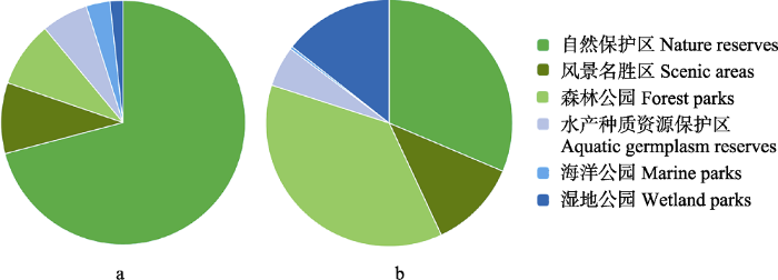
图1
我国主要自然保护地的面积(a)与数量(b)占比。相关数据引自唐小平和栾晓峰(2017); Huang YZ等(2019)。
Fig. 1
Area (a) and number (b) (%) of major types of protected areas in China. Related data were obtained from Tang & Luan, 2017; Huang YZ et al, 2019.
然而, 过去我国自然保护地的建立, 通常是各部门分头设立不同类型的自然保护地, 缺乏顶层的自然保护地体系设计和统一管理(Li et al, 2016)。这使得重叠设置、多头管理、边界不清、权责不明、保护与发展矛盾突出等问题日益积累, 制约了我国自然保护地的有效性。为了解决上述问题, 中国政府自2018年3月以来开始进行机构改革, 旨在建立统一、规范和有效的自然保护地体系(Xu et al, 2019b)。在此基础上, 2019年6月26日, 中共中央办公厅和国务院办公厅进一步印发了《关于建立以国家公园为主体的自然保护地体系的指导意见》(
1.2 代表性
代表性指标可以反映已建自然保护地是否覆盖了足够的生物多样性重要区域以及重要生态系统和重要物种。从自然保护地类型来看, 我国对于自然保护区的相关研究比较全面, 环保、林业等部门也先后组织开展了全国自然保护区发展规划的编制, 不断推动自然保护区空间布局的优化完善。国内相关学者通过空缺分析(Lü et al, 2017; Guo et al, 2019)、保护热点(Chi et al, 2017; Xu et al, 2018)、系统保护规划(Wu et al, 2014; Zhang YB et al, 2017)等技术方法, 分别探索了我国自然保护地特别是自然保护区对于不同类群生物多样性及生态系统服务的覆盖程度, 即代表性。总体来看, 我国已建的自然保护区保护了超过80%的自然植被群落以及85%以上的野生动植物(Cao et al, 2015)。其中, 自然保护区对兰科植物和哺乳动物的覆盖程度较好, 相关研究显示我国自然保护区保护了大约97%的兰科植物(Zhang et al, 2015), 以及534种(占评估总数的90.36%)哺乳动物(夏欣等, 2018)。当前阶段正在建设的大熊猫国家公园试点, 将通过整合81个各级各类自然保护地, 覆盖87.5%的已知野生大熊猫(Ailuropoda melanoleuca)种群以及70.25%的大熊猫栖息地, 并同时实现对至少3,446种已知植物和641种脊椎动物的保护(Huang et al, 2020)。
然而, 我国自然保护地空间布局仍不足以满足生物多样性保护和提供生态系统服务的需求, 我国32个陆域生物多样性保护优先区域中, 自然保护地覆盖的比例不足30%的有25个, 且多位于人口较多的区域(李俊生等, 2016; Tian et al, 2019)。通过与全国尺度的生物多样性关键区域保护状况叠加分析, 发现我国自然保护区在东部和南部地区还存在空缺(Guo & Cui, 2015)。从物种类群来看, 我国已建的自然保护区对于濒危植物、两栖动物和爬行动物的栖息地保护不足(Li & Pimm, 2016; Xu et al, 2017b)。例如, 基于中国濒危药用植物分布热点的保护空缺分析表明, 有30个濒危药用植物分布热点县域尚未建设自然保护区(Chi et al, 2017)。已知有17种极小种群野生植物未受到国家级或省级自然保护区覆盖(张则瑾等, 2018)。从生态系统服务来看, 四类关键生态系统服务(水源涵养、土壤保持、防风固沙、碳汇)的重要区域还存在较大的保护空缺(Xu et al, 2017b)。相对来说, 其他类型自然保护地对于生物多样性的代表性研究相对较少(Zhang LB et al, 2017)。
1.3 有效性
自然保护地只有在有效管理的前提下才能发挥其环境效益、社会效益和经济效益, 其有效性主要通过管理有效性、保护成效、连通性三个方面, 来判断自然保护地在多大程度上实现了当初预期的保护目标。从我国自然保护地的有效性来看, 无论是管理有效性, 还是保护成效以及连通性等方面, 均取得了较大的进展。
1.3.1 管理有效性
管理有效性评估被认为是提升自然保护地管理质量的重要机制, 以及保障生物多样性就地保护工作健康发展的前提(Stoll-Kleemann, 2010)。我国相关部门及学者围绕评估指标及方法均开展了较为系统的研究, 包括自然保护地管理快速评估和优先性确定(rapid assessment and prioritization of protected area management, RAPPAM)方法(栾晓峰等, 2009)、世界银行(World Bank, WB)和世界自然基金会(World Wildlife Fund, WWF)发布的管理有效性跟踪工具(management effectiveness tracking tool, METT)等方法(Quan et al, 2011), 以及原环境保护部发布的《自然保护区管理评估规范》(HJ 913-2017)、原国家林业局发布的《自然保护区有效管理评价技术规范》(LY/T 1726-2008)等标准规范。在此基础上, 相关主管部门对各类自然保护地管理有效性开展了广泛评估, 推动了自然保护地管理质量与管理水平的不断提升。例如, 2003-2005年, 原国家林业局参照IUCN自然保护地管理有效性框架, 对634个林业系统的自然保护区进行了管理有效性评价。自2007年以来, 原环境保护部会同原国土资源部、水利部、原农业部、原国家林业局、中国科学院、原国家海洋局等自然保护区主管部门(简称“七部委”)共同开展评估工作, 至2016年已完成394处国家级自然保护区的评估(李俊生等, 2015; 王伟, 2018); 2017-2018年, 原环境保护部等七部委再次对长江经济带11省(市)共120处国家级自然保护区开展了管理评估, 系统梳理了保护区管理现状、工作进展及存在的问题, 结果表明120处保护区平均得分为81.41分, 其中46.3%的保护区评分等级为“优”, 44.7%的保护区为“良”, 7.3%的保护区为“中”, 1.7%的保护区为“差” (冯春婷等, 2020)。此外, 一些自然保护区也通过自评估或第三方评估等方式, 开展了管理有效性评估工作, 例如山东黄河三角洲国家级自然保护区(He et al, 2012)、云南西双版纳国家级自然保护区(林建勇, 2017)等。从上述这些评估结果来看, 我国自然保护区的管理有效性整体较好, 特别是级别较高、建立时间较长以及位于社会经济发展较好省份的自然保护区, 其管理状况评分相对更高(李俊生等, 2015)。
除自然保护区外, 我国也针对风景名胜区开展了相关管理有效性评估工作或案例研究。例如, 为指导国家级风景名胜区管理评估工作, 住房和城乡建设部2015年印发了《国家级风景名胜区管理评估和监督检查办法》, 包括规划编制与实施、保护措施及效果、配套管理制度、信息系统、违法违规行为等评估内容, 并组织开展了年度评估和定期评估; 2017年, 我国还发布了《风景名胜区管理通用标准》(GB/T 34335-2017)。一些省份也制定了本省的相关办法并组织开展了管理评估工作, 如浙江省住房和城乡建设厅2017年印发了《浙江省风景名胜区管理评价办法》等, 一些学者也在杭州西湖(李宁汀等, 2018)、宁波东钱湖(高黑和张秀珍, 2018)等风景名胜区开展了案例研究。相对于自然保护区、风景名胜区来说, 其他类型自然保护地如湿地公园(吴后建等, 2015)、海洋特别保护区(Wu et al, 2017)等仍以个案研究为主, 尚缺乏系统性的管理有效性评估方法与规范, 也未能形成常态化的管理评估机制。
1.3.2 保护成效
自然保护区管理有效性评估主要依赖文献调研以及专家根据自然保护区管理者的描述并结合自己的经验给出定性判断, 往往缺乏生物多样性动态变化的量化数据支持。因此, 自然保护地在维持生物多样性和保障生态系统服务等方面的综合成效, 逐渐成为近年来国内外政府及学者关注的热点(王伟等, 2016)。我国相关部门也愈发重视自然保护地的保护效果, 并相继开展了一系列保护成效评估项目。
近年来的一些自然保护地保护成效评估相关研究结果表明, 我国自然保护地在保护一些重要生态系统及重点保护物种等方面, 取得了一定成效, 但总体来看保护成效仍有待提升(王伟等, 2016; Huang YZ et al, 2019)。在自然生态系统方面, 我国多数自然保护地对减缓森林丧失(Ren et al, 2015; Zhao et al, 2019)起到了较为积极的作用。例如, Yang等(2019)基于2000-2015年全球森林观察(Global Forest Watch)数据分析了我国472个自然保护地对减缓森林丧失的效果, 发现71%的自然保护地起到了积极的作用。而我国自然保护地对于湿地生态系统的保护则有待提升, 虽然在一些保护地取得了较好的成效, 如青海三江源(Huang L, 2019)、内蒙古辉河(靳勇超等, 2015)等自然保护区, 但多数自然保护地对于湿地的保护效果均不理想(Lu et al, 2016)。相对来说, 我国自然保护地对草地、荒漠、海洋等生态系统的保护成效研究较少, 全国层面的整体情况仍有待进一步加强(Fan et al, 2013; 宋瑞玲等, 2018)。
与此同时, 我国自然保护地对部分重点保护物种种群数量或栖息地面积的恢复起到了积极作用(蒋志刚, 2019), 特别是大熊猫(Wei et al, 2018)、朱鹮(Nipponia nippon) (Sun et al, 2016)、川金丝猴(Rhinopithecus roxellanae) (王翠玲等, 2017)、普氏原羚(Procapra przewalskii) (平晓鸽等, 2018)等受到较多关注的旗舰种。例如, 1980-2010年来以大熊猫为主要保护对象的自然保护区面积增加了3.5倍(Wei et al, 2018), 在保护大熊猫的同时, 也保护了许多与大熊猫同域分布的重点保护物种(Li & Pimm, 2016), 并为当地提供调节、供给、文化等多种生态系统服务(Wei et al, 2018); 自然保护区内的大熊猫栖息地面积比例从1976年的3.7%增加到2013年的33.3%, 但大熊猫仍然面临着栖息地破碎化的风险(Xu et al, 2017a)。朱鹮的分布范围从陕西汉中朱鹮国家级自然保护区逐渐向周边区域扩散(张海斌等, 2016), 种群数量从1981年最初发现的7只个体增加到当前的大约2,600只, 但同时也存在近亲繁殖严重、遗传多样性较低等问题(Feng et al, 2019)。此外, 除这些受关注较多的物种以外, 许多物种都面临数据本底资料不足等问题, 其数量、分布、受威胁程度及保护成效仍有待进一步查明。
1.3.3 连通性
由于单一的自然保护地难以有足够大的面积来维持和保护所有的生物多样性, 所以需要通过合适的廊道将这些自然保护地连接成为大的自然保护地网络, 从而实现全国或区域尺度生物多样性保护的统筹实施与协调管理。因此, 提升自然保护地之间的连通性是进一步实现生物多样性就地保护目标的关键因素之一(Saura et al, 2017)。近年来, 我国为推动全国及不同地理区域尺度的自然保护地网络建设, 开展了多项研究与尝试, 特别是针对自然保护区已形成了布局较为合理的生物多样性就地保护网络。2013年, 原环境保护部组织开展了全国自然保护区发展规划(2015-2025年)的编制工作, 基于“生物多样性保护核心区域”以及连接核心区域之间的“廊道”两个基本要素(Biondi et al, 2012), 提出了自然保护区网络布局规划方案( 环境保护部 (2015) 全国自然保护区发展规划(2015-2025年) (报批稿).)。原国家林业局也发布了《陆生野生动物廊道设计技术规程》(LY/T 2016-2012), 并通过建设大熊猫国家公园试点(Huang et al, 2020)、东北虎豹国家公园试点(Qi et al, 2020)的方式, 不断提升重点物种保护的连通性。一些学者也就进一步提升自然保护地的连通性开展了大量研究, 如Liang等(2018)基于保护优先区域和最小成本廊道的网络分析方法, 提出了我国的自然保护地网络框架建议; Su等(2019)应用Linkage Mapper廊道模拟工具, 提出了建设滇金丝猴(Rhinopithecus bieti)潜在保护廊道的建议, 以期提升5个滇金丝猴自然保护区(芒康、白马雪山、云岭、哈巴雪山、云龙天池)之间的连通性。不过总体来看, 由于我国自然保护地整合优化工作仍在进行中, 全国层面的自然保护地网络布局(陆域及海域)仍有待进一步完善(Cao et al, 2015; Li & Fluharty, 2017; 马童慧等, 2019)。
2 其他生物多样性就地保护措施
按照《生物多样性公约》“爱知目标”的要求, 目标11不仅包括自然保护地的建设及保护管理, 同时还包括在自然保护地之外的区域开展持续有效的生物多样性保护措施, 从而维持和改善生物多样性及生态系统服务(Secretariat of the Convention on Biological Diversity, 2014)。近年来我国也一直在推动其他生物多样性就地保护措施的实施, 在2010年发布的《中国生物多样性保护战略与行动计划(2011-2030年)》中, 就将“加强自然保护区外生物多样性的保护”列为一项优先行动(中华人民共和国环境保护部, 2010)。这些其他生物多样性就地保护措施, 包括开展重点生态保护修复工程, 建立生态保护红线体系, 以及自然保护小区、风水林、神山圣湖、社会公益保护地等其他就地保护区域。
2.1 生态保护修复工程
近几十年来, 为实现生物多样性保护、减少土地退化、降低空气污染、应对气候变化等目标, 我国政府逐步推行实施了各项生态保护修复工程(Lu et al, 2018; Wen & Théau, 2020)。在森林生态系统保护修复方面, 我国实施了天然林保护、退耕还林还草等六大林业生态保护修复工程等(Hua et al, 2016; Viña et al, 2016)。与此同时, 我国政府还提倡通过改变当地社区的收入结构, 从直接依赖土地的收入转变为非农收入, 逐步减轻对森林资源的直接依赖(Viña et al, 2016)。基于卫星的观测数据也证实我国大多数地区正在“变绿”的趋势(Chen et al, 2019)。在草原生态系统方面, 我国政府实施了京津风沙源治理、退耕还草、草原生态补偿机制等措施(Hu ZM et al, 2019; Zhao et al, 2020)。在湿地生态系统保护修复方面, 自1998年长江中下游发生大规模洪灾之后, 我国启动了多个大型湿地保护恢复计划, 包括2000年发布实施的《中国湿地保护行动计划(2011-2020)》, 2003年发布实施的《全国湿地保护工程规划(2002-2030)》等(Jiang & Xu, 2019; Xu et al, 2019a)。2016年, 国务院办公厅印发了《湿地保护修复制度方案》(
随着这些生态保护修复工程的不断实施, 许多学者也围绕这些措施在生物多样性保护和保障生态系统服务两大主要目标方面的生态效益开展了大量研究。总体来看, 我国已实施的生态工程在增加植被覆盖、增强固碳、提升水土保持功能、增加植被净初级生产力、提升防风固沙能力等方面均产生了积极的效果。例如, 通过实施退耕还林工程, 2007-2017年黄土高原的总体森林面积每年平均增加约600 km2 (Zhou et al, 2019)。在我国西南喀斯特地区, 生态工程的实施降低了石漠化土地退化的风险, 2001-2012年间云南、广西、贵州三省(区)植被地上生物量固碳能力增加了约9% (Tong et al, 2018)。与未实施相关工程的蒙古国相比, 我国内蒙古自治区通过一系列政策及项目的实施, 在草原面积恢复和净初级生产力的提升方面均为草原生态系统带来了更为积极的效果(Zhang YZ et al, 2020)。Li等(2019)以大型底栖动物遗传多样性、物种分类多样性和功能多样性为指标构建了淡水湿地恢复效果评估的框架体系, 并在山东黄河三角洲进行了案例研究, 结果表明恢复措施对改善生物多样性起到了积极作用。
2.2 生态保护红线
2011年, 我国启动了生态保护红线的划定工作, 通过综合评估区域生物多样性、关键的生态系统服务(如授粉和土壤保持)、对侵蚀的敏感性、以及对自然灾害的恢复能力, 在重点生态功能区、生态环境敏感区和脆弱区等区域划定生态保护红线(高吉喜, 2015)。生态保护红线是我国自然保护地体系的重要补充, 在涵盖我国绝大部分自然保护地体系的同时, 实现对自然保护地以外的珍稀濒危物种及其栖息地、生态系统服务极为重要的区域以及生态环境极为敏感脆弱区域的保护目的(Gao et al, 2020)。自2014年以来, 为实现生态保护与经济社会发展的和谐平衡, 生态保护红线作为国家战略得到进一步巩固和应用(Xu XB et al, 2019), 为国土空间规划框架提供了重要经验(Schmidt-Traub et al, 2020)。到目前为止, 我国已有15个省(自治区、直辖市)完成了生态保护红线的划定, 其他省份也计划于2020年底完成(Jiang et al, 2019)。生态保护红线划定后, 预计将以接近30%的国土面积, 来实现98%以上的国家重点保护物种、90%以上的优良生态系统和自然景观、三级以上河流源头区等重要区域的保护(高吉喜等, 2019)。
目前许多学者在生态保护红线划定与评估的过程中, 研究探索了多种不同的技术方法, 其中生态系统服务评估通常是生态保护红线划定的基础。例如, Bai等(2018)在上海生态保护红线划定的研究中, 以保障固碳、水质净化、水土保持等生态系统服务为目标, 建议将上海陆地总面积的16%作为生态保护红线。Xu XB等(2019)基于5个关键生态系统服务指标(水资源保护、土壤保持能力、固碳能力、生物多样性保护、湖泊蓄滞洪区)结合2个生态脆弱性指标(地质灾害易感性、石漠化), 提出了长江经济带生态保护红线划定方法, 并建议将55.5%的空间划为生态保护红线。此外, 为进一步探索生态保护红线的成效, 侯鹏等(2018)对海南和广东两省的生态保护红线成效进行了评估, 结果表明这两个省的生态保护红线在保障自然生态系统面积、改善区域生态系统质量和提升区域生态系统服务等方面, 均起到了明显的效果。不过, 目前我国生态保护红线主要还处于划定阶段, 在后续保护成效评估方面仍存在诸多挑战, 如划定不科学、数据缺乏、监测评估指标体系不完善等(江波等, 2019)。个别生态保护红线在划定之时, 由于一些历史遗留问题, 将部分永久基本农田、重大基础设施工程等区域划入了红线, 为解决上述矛盾, 自然资源部和生态环境部共同部署开展了生态保护红线评估工作, 以期通过生态保护红线的优化调整, 实现“生态功能不降低、面积不减少、性质不改变”的目标(徐樑等, 2020)。
2.3 其他就地保护区域
除了政府主导的就地保护措施, 我国还有一些民间的保护形式, 如自然保护小区、风水林/神山圣湖和社会公益保护地等, 这些区域均可算作是“爱知目标”所提倡的“其他有效的基于区域的保护措施” (other effective area-based conservation measures, OECMs)。OECMs通常由当地社区自发组织或一些社会组织通过与政府或当地社区合作等方式, 以保护自然保护地外重要的生态系统、栖息地和野生动物廊道(IUCN-WCPA Task Force on OECMs, 2019)。
自然保护小区是指主要由县级以下(含县级)人民政府设立的面积较小的保护区(点), 面积一般不超过1,000 ha, 管理目标为保护国家或地方重点保护的野生动植物群落及栖息地, 珍贵植物的原生地, 有保存价值的原始森林、原始次生林和水源涵养林等(崔国发, 2013)。据统计, 我国大约有50,000个自然保护小区, 总面积约为150万ha (唐小平和栾晓峰, 2017)。这些自然保护小区作为自然保护地体系的补充, 起到了积极的作用。例如, 云南西双版纳的兰科植物中虽有142种位于自然保护地之外, 但其中有44种位于青石寨自然保护小区内(面积约9 ha), 有42种位于银厂自然保护小区内(面积约588 ha) (Liu et al, 2015)。
风水林/神山圣湖通常是我国一个区域内的民族世世代代通过传统的土地利用和文化习俗所形成的自然景观, 主要依靠宗教信仰、狩猎禁忌和“圣地”保护等本土知识或乡规民约的约束力量, 对于生物多样性的保护往往起到了极为重要的作用(Grumbine & Xu, 2011; 陈涵子和吴承照, 2019)。例如, Shen等(2015)将西藏神山与自然保护区在保护森林方面的贡献进行了对比分析, 结果显示在森林覆盖率和减缓森林丧失两个方面, 神山对于森林的保护成效更加显著。Zhang JQ等(2020)通过走访西双版纳的社区, 分析当地天然林片段(natural forest fragments)得以保留的原因, 发现大多数受访者(超过96%)认为是由于圣山、风水林或其他文化传统的保护效果。
近年来, 我国逐渐出现了一种新型的就地保护形式——社会公益保护地(civil protected areas, CPAs), 这是由我国民间机构、社区或个人治理或管理的保护区域, 以促进自然保护和可持续发展(IUCN, 2019)。社会公益保护地建议选择目前还没有纳入自然保护地体系的区域开展保护工作; 对于已建自然保护地, 在取得当地政府及自然保护地主管部门的许可后, 也可以开展社会公益保护地建设(IUCN, 2019)。四川老河沟作为我国第一个社会公益保护地, 近年来吸引了越来越多的学者来此开展研究, 2011-2014年的红外相机调查结果发现该区域有兽类24种, 其中包括大熊猫、川金丝猴等9种国家重点保护物种(李晟等, 2016); Fang等(2018)还发现该区域川金丝猴种群密度约为10.6只/km2, 高于陕西和湖北相关自然保护区内的川金丝猴种群密度。可以看出, 社会公益保护地为多元化社会参与生物多样性就地保护贡献了民间力量。
3 问题与展望
本文系统梳理了我国近年来特别是近十年来在生物多样性就地保护方面所取得的各项成效。总体来看, 我国基本建立了具有中国特色的生物多样性就地保护与管理体系, 实施了各项生物多样性保护恢复措施, 取得了一系列重大进展(表1)。随着生物多样性保护、可持续发展以及全球变化成为了生态学和环境科学研究的三大前沿领域(李文华, 2000), 我国在保护和恢复生物多样性的同时, 也为推动实现2030年可持续发展目标做出了重要贡献(Sun et al, 2018; Xu et al, 2020)。尽管如此, 我国在生物多样性保护和经济发展之间仍然存在着不平衡的情况, 一些重要生态系统如湿地等还存在不同程度的破坏和丧失(Xu et al, 2019a), 某些类群(如两栖类物种, 蒋志刚, 2016)的受威胁比例仍然高于全球平均水平。在全球生物多样性未来发展的关键之年, 我国作为《生物多样性公约》第十五次缔约方大会的东道主, 有责任向全球贡献生物多样性保护的中国智慧。为此, 本文对照《中国生物多样性保护战略与行动计划(2011-2030年)》优先领域四“加强生物多样性就地保护”的各项要求(中华人民共和国环境保护部, 2010), 分析总结了当前我国生物多样性就地保护仍然存在的问题与不足; 并在此基础上, 对将来我国生物多样性就地保护提出了进一步建议与展望。
表1 中国生物多样性就地保护的阶段性进展与不足
Table 1
| 主要进展 Major progress | 主要不足 Major weak points | ||
|---|---|---|---|
| 1. 自然保护地建设及保护管理成效 Development and conservation effectiveness and management effectiveness of protected areas | |||
| 1.1 数量与面积 Numbers and areas | 我国已建立约1.18万个自然保护地, 保护面积覆盖我国陆域面积的18%、管辖海域面积的4.1%。China has established more than 11,800 protected areas covering 18 percent of its land area and 4.1 percent of its sea area. | 海洋自然保护地的面积比例不足。The area of marine protected areas is still lacking. | |
| 1.2 代表性 Representativeness | 我国已建的自然保护区保护了超过80%的自然植被群落以及85%以上的野生动植物, 对兰科植物、哺乳动物的覆盖程度较好。More than 80% of natural vegetation communities and 85% of wild animals & plants have been represented in current nature reserves. Especially, the species of Orchidaceae and mammals are well-represented. | 自然保护地仍不足以满足生物多样性保护和维系生态系统服务的需求, 存在保护空缺。而且自然保护区以外的其他类型自然保护地研究相对较少。There are still conservation gaps of current protected areas to fulfill the requirements of biodiversity conservation and ecosystem services maintenance. Less studies have been carried on other protected areas except for nature reserves. | |
| 1.3 有效性 Effectiveness | |||
| 管理有效性 Management effectiveness | 我国自然保护区的管理有效性整体较好, 特别是级别较高、建立时间较长以及位于社会经济发展较好省份的自然保护区, 其管理状况相对较好。In general, management effectiveness of nature reserves in China are relatively good, especially those with higher management level, longer period from establishment, or in better economic provinces. | 自然保护区还普遍存在范围边界与土地权属不清、管理机构不健全、专业技术人员缺乏、资金投入不足、动态监测不足、开发建设活动影响等方面的问题。其他类型自然保护地研究相对较少。There are still some problems of nature reserves in China, such as the lacking information of boundaries and land tenures, the poorly organized institution, the lacking of staff, funding, and monitoring, and the impacts of construction activities. Less studies have been carried on other protected areas except for nature reserves. | |
| 保护成效 Conservation effectiveness | 自然保护地对一些重要生态系统及重点保护物种的保护取得了一定成效。There are some achievements of protected areas in conserving some ecosystems and key protected wild animals and plants. | 除受关注较多的物种以外, 许多物种其数量、分布、受威胁程度及保护成效仍不清楚。Except for those species with more attention, the information (number, distribution, threatened status, and conservation effectiveness) of most species is still not clear. | |
| 连通性 Connectivity | 许多研究均提出了潜在的保护廊道建议, 正在建设的国家公园试点提升了部分重点物种(如大熊猫Ailuropoda melanoleuca、东北虎Panthera tigris altaica)的保护连通性。Potential conservation corridors have been proposed by many studies. The well-connected national park pilots to improve the connectivity of some key wild animals (such as Ailuropoda melanoleuca and Panthera tigris altaica) have been developing. | 廊道建设及自然保护地之间的连通性均有待加强, 全国层面的自然保护地网络布局仍有待进一步完善。The establishments of corridors to improve the connectivity of protected areas need to be strengthened. The protected areas network of the whole country is still incomplete. | |
| 2. 其他生物多样性就地保护措施 Other in-situ conservation measures | |||
| 2.1 生态保护修复工程 Ecological protection and restoration projects | 生态保护修复工程在增加植被覆盖、增强固碳、提升水土保持功能、增加植被净初级生产力、提升防风固沙能力等方面均产生了积极的效果。The ecological protection and restoration projects have obtained great achievements, such as the increasing of vegetation coverage, and the improvement of carbon sequestration, water and soil retention, net primary productivity, and sand fixation functions. | 早期的生态保护修复通常以要素为对象, 割裂了生态系统的整体性; 一些重要生态系统如湿地、草地等仍存在不同程度的退化。Previous ecological protection and restoration projects usually treated the single element as the object, ignoring the integrity of ecosystem. Some important ecosystems, such as the grassland and wetland, are still facing the risk of degradation. | |
| 2.2 生态保护红线 Ecological conservation red line (ECR) | 已有15个省(自治区、直辖市)完成了生态保护红线的划定。The ECR delimitation had been finished in 15 provinces. | 一些历史遗留问题仍然存在, 生态保护红线的保护成效仍有待进一步评估。There are still some historical issues inside the ECRs. The conservation effectiveness of ECRs needs to be further assessed. | |
| 2.3 其他有效的基于区域 的保护措施 Other effective area-based conservation measures (OECMs) | 我国OECMs (如自然保护小区、风水林/神山圣湖、社会公益保护地等), 为生物多样性就地保护贡献了民间力量。The OECMs, such as the mini natural reserves, the sacred mountains and lakes, and the civil protected areas, have made non-governmental contributions to the in-situ conservation of biodiversity in China. | 我国OECMs的责任主体、位置边界及其在生物多样性保护方面的效果等情况仍然不清。The responsibility body, boundaries and locations, and the conservation effectiveness of OECMs are still unclear. | |
3.1 问题与不足
3.1.1 自然保护地整体保护能力仍有待提升
自然保护区作为我国自然保护地体系的基础, 已形成了较为系统的生物多样性就地保护网络。通过一系列自然保护区发展规划的统筹实施, 对重要生态系统、重点保护物种的保护起到了积极作用, 特别是针对旗舰物种的保护方面, 一些物种种群数量或栖息地面积得到了逐步恢复(蒋志刚, 2019)。此外, 还在东北地区黑龙江流域中蒙俄跨界保护区网络建设、西南地区与东盟各国(如老挝、缅甸等)之间的跨国界保护区及跨界保护廊道建设、西北地区中俄哈蒙四国跨界保护规划等方面, 不断加强跨界生物多样性保护合作(王伟等, 2014)。然而, 从总体来看, 现有自然保护地体系仍然存在空间布局不合理、交叉重叠等问题, 同时一些重要区域仍然存在保护空缺(唐小平等, 2020)。很多自然保护地内大型食肉动物如豹(Panthera pardus)、狼(Canis lupus)、豺(Cuon alpinus)等, 分布范围仍不断退缩, 种群未得到有效维持(Li et al, 2020)。
3.1.2 生物多样性保护优先区域仍然存在保护空缺
《中国生物多样性保护战略与行动计划(2011-2030年)》按照生态系统类型的代表性、特有程度、特殊生态功能, 以及物种的丰富程度、珍稀濒危程度、特有性等因素, 划定了35个生物多样性保护优先区域, 包括32个内陆陆地及水域生物多样性保护优先区域, 以及3个海洋与海岸生物多样性保护优先区域(李俊生等, 2016)。虽然当前正在建设的所有国家公园体制试点均位于生物多样性保护优先区域范围内, 但是生物多样性保护优先区域内仍然存在大量保护空缺, 32个内陆陆地及水域生物多样性保护优先区域中, 仅有7个区域内的自然保护地面积占比超过30%; 其余保护比例较低的生物多样性保护优先区域则大多位于人口较多的区域(Tian et al, 2019)。
3.1.3 自然保护区管理质量有待提升, 缺乏公共协商机制
自然保护区是我国自然保护地体系的基础(Li et al, 2016)。从2007-2016年七部委联合完成的394处国家级自然保护区管理评估工作的结果来看, 国家级自然保护区还普遍存在范围边界与土地权属不清、管理机构不健全、专业技术人员缺乏、资金投入不足等问题(李俊生等, 2015)。2017-2018年长江经济带11省(市) 120处国家级自然保护区管理评估结果同样表明, 自然保护区在机构设置与人员配置、专业技术能力、动态监测、开发建设活动影响等方面的管理工作仍有待提升(冯春婷等, 2020)。此外, 一些自然保护区在管理工作中忽略了社区居民的主体性, 只是把社区居民当成管控对象, 并没有充分调研社区居民的意见和想法, 公众协商机制的缺乏, 使得社区居民的发展需求与自然保护区保护目标之间的矛盾进一步加剧。
3.1.4 自然保护地以外的其他就地保护工作仍在探索阶段
自然保护地以外的其他就地保护区域(OECMs)作为各国逐渐认同的一种就地保护措施, 尽管有时并不是以生物多样性保护作为最初设立的首要目标, 不过OECMs往往对于提升区域生物多样性保护的代表性与连通性, 以及维系生态系统服务与功能等方面发挥了重要作用(Bhola et al, 2020)。我国近年来虽然逐步推动和引导OECMs的建设, 然而目前我国OECMs的责任主体和位置边界等本底情况, 及其在生物多样性保护方面的效果等信息, 均有待进一步掌握。此外, OECMs的形式多样, 除政府主导以外, 往往还有很多是民间自发组织设立的, 关于我国OECMs的治理方式和治理体系的研究仍然存在不足。
3.2 建议与展望
3.2.1 制定更为具体的、可衡量的生物多样性就地保护目标
从“爱知目标”的实现情况来看, 我国自然保护地在面积方面虽已超过保护至少17%陆域国土面积的目标, 但在代表性、有效性、连通性方面仍有待进一步加强。一些学者也发现, 如果制定更为具体和量化的生物多样性目标(如17%的明确数字要求), 并且措辞容易理解, 则有利于目标的实现(Green et al, 2019)。如关于2030年自然保护地占陆域国土面积的比例, 全球自然协议(A Global Deal for Nature, GDN)发现30%的目标可以实现全球67%的陆地生态区(terrestrial ecoregions)的保护(Dinerstein et al, 2019)。因此, 建议我国应制定更为具体和量化的生物多样性就地保护目标, 确保措辞清楚明确, 以便将目标转化为可在国家和各省层面成功实施的政策措施。
3.2.2 加大力度减少物种受威胁程度, 特别是受关注较少的物种
近年来许多学者提出, 实现生物多样性就地保护的目标(目标11), 是否能够有效减少物种的灭绝(目标12)和恢复与保障生态系统服务(目标14) (Baillie & Zhang, 2018)? 从我国物种保护情况来看, 尽管对于大熊猫、朱鹮等旗舰物种的保护取得了较为显著的成效, 然而许多受威胁物种的生存状况却变得更为严峻, 甚至出现了一些物种灭绝的报道, 如白鲟(Psephurus gladius) (Zhang H et al, 2020)等。物种致危因素中, 自然生境的破坏和/或碎片化是导致许多物种受威胁程度增加甚至灭绝的最重要原因(Volis, 2016; 蒋志刚, 2016; 覃海宁和赵莉娜, 2017)。此外, 由于人类活动的影响, 我国分布范围较窄的物种正在被广泛分布的物种取代(Xu WB et al, 2019)。一些学者发现建立自然保护地、加大保护资金投入, 以及在国家或区域层面的科学研究特别是与我国生态保护相关的研究, 对推动受威胁物种的保护发挥了重要作用(Hu YS et al, 2019), 并建议增加跨学科保护研究项目资助力度, 加快培养高质量的研究人员, 不断提升我国受威胁物种特别是脊椎动物保护的研究力度(Fan et al, 2020)。因此我们建议, 在加大保护和科研资金投入、增设自然保护地的过程中, 以过去受关注较少的物种特别是受威胁物种为重点, 同时改善物种栖息地质量并建设生物廊道, 以实现物种迁移和扩散的需求。
3.2.3 以保障和提升生态系统服务为目标, 提升生态系统保护修复的系统性与整体性
从生态系统来看, 我国自然保护地空间布局仍不足以实现保障重要生态系统服务的目标(Xu et al, 2017b), 一些重要生态系统仍然存在退化的风险, 如湿地(Xu et al, 2019a)、草地(Chen et al, 2020)等。由于我国生物多样性富集区域往往与经济发展落后的地区具有高度的重合性, 水污染、水资源稀缺和土地退化等环境问题对我国的可持续性仍存在较大威胁(Xu et al, 2020)。相关研究表明, 基于水资源供给服务的模型预测, 可以为我国未来不同土地利用变化和气候情景下的水资源规划提供建议(Zheng et al, 2019)。为此, 很多学者也提出建立以保障和恢复生态系统服务为目标的自然保护地体系(He et al, 2018; Jiang & Xu, 2019), 并在综合考虑生物多样性、生态系统服务、自然景观和自然遗迹的基础上, 编制统一的自然保护地体系规划(Ma et al, 2019; Xu et al, 2019b)。我们也建议, 在生态系统保护修复过程中, 要注重生态系统各要素之间的关联, 以系统性和整体性的理念(彭建等, 2019)进行统筹实施。此外, 加强海洋等生态系统的就地保护。在此基础上, 进一步利用好生物多样性富集区域的优质生态资源, 转变当地社区的生产生活方式, 维持好生态系统的调节服务, 用好生态系统的供给服务, 探索生态系统服务价值实现的体制机制。
3.2.4 加强自然保护地以外的生物多样性就地保护
我国生态保护红线的划定和勘界工作即将完成, 生态保护红线涵盖了我国绝大部分自然保护地, 但位于自然保护地以外的生态保护红线区域其作用仍有待进一步评估。此外, 我国对于OECMs的情况和特征往往了解较少, 这些OECMs对于生物多样性保护的效果仍有待探索。建议下一步以政府引导的形式, 以保护自然保护地外重要的生态系统、珍稀濒危物种栖息地以及极小种群野生物种等为目标, 采用政府主导、私人主导、或与当地社区合作等不同治理方式, 推动OECMs的建设与管理。OECMs同时也可以成为自然保护地体系的有益补充, 或作为廊道以实现自然保护地之间的连接, 从而推动形成更为有效的生物多样性就地保护网络。
3.2.5 完善长期监测体系, 为生物多样性就地保护成效评估提供数据支撑
此外, 生物多样性就地保护目标实现与否, 往往需要对生物多样性要素的变化规律进行长期监测(Turner, 2014)。尽管我国已经建立了中国森林生物多样性监测网络、中国生态系统研究网络、中国生物多样性监测与研究网络、全国生物多样性观测网络等, 为生物多样性就地保护研究提供了基础平台, 然而, 中国现有的生物多样性监测研究网络及数据平台系统性相对不足, 缺乏统一规划协调(马克平等, 2018)。因此, 亟需进一步围绕不同尺度生物多样性长期动态变化的趋势, 以保护成效评判为目标, 建立完善的监测体系和数据共享机制, 从而为定期量化评估生物多样性就地保护成效提供科学有效的数据支撑。
参考文献
Developing China’s Ecological Redline Policy using ecosystem services assessments for land use planning
DOI:10.1038/s41467-018-05306-1
URL
PMID:30072771
[本文引用: 1]

Ecosystems services (ES) assessment is a significant scientific topic recognized for its potential to address sustainability issues. However, there is an absence of science-policy frameworks in land use planning that lead to the ES science being used in policy. China's Ecological Redline Policy (ERP) is one of the first national policies utilizing multiple ES, but there is no standardized approach for working across the science-policy interface. We propose a transdisciplinary framework to determine ecological redline areas (ERAs) in Shanghai using: ES, biodiversity and ecologically fragile hotspots, landscape structure, and stakeholder opinions. We determine the five criteria to identify ERAs for Shanghai using multi-temporal, high resolution images (0.5 m) and biophysical models. We examine ERP effectiveness by comparing land use scenarios for 2040. Compared to alternative land uses, ES increase significantly under the ERP. The inclusion of ES in spatial planning led stakeholders to increase terrestrial habitat protection by 174% in Shanghai. Our analysis suggests that strategic planning for ES could reduce tradeoffs between environmental quality and development.
Space for nature
DOI:10.1126/science.aau1397 URL PMID:30213888 [本文引用: 1]
Perspectives on area-based conservation and its meaning for future biodiversity policy
Natura 2000 and the Pan-European Ecological Network: A new methodology for data integration
Analysis of the network of protected areas in China based on a geographic perspective: Current status, issues and integration
China and India lead in greening of the world through land-use management
From fengshui forests to national parks: The logic of collective action of stakeholders
从风水林到国家公园——利益相关者集体行动的逻辑
An integrated approach for risk assessment of rangeland degradation: A case study in Burqin County, Xinjiang, China
Threatened medicinal plants in China: Distributions and conservation priorities
A Global Deal for Nature: Guiding principles, milestones, and targets
Build up conservation research capacity in China for biodiversity governance
Land-cover changes of national nature reserves in China
Preliminary report on Sichuan golden snub-nosed monkeys (Rhinopithecus roxellana roxellana) at Laohegou Nature Reserve, Sichuan, China
Evaluation of management status of national nature reserves in the Yangtze River Economic Belt
长江经济带国家级自然保护区管理状况评价
The genomic footprints of the fall and recovery of the crested ibis
Assessment guidelines for the implementation of the planning of scenic area in Zhejiang Province
浙江省风景名胜区规划实施评估导则研究
Exploring the delineation and supervision of ecological protection red-lines in China
探索我国生态保护红线划定与监管
How China will protect one-quarter of its land
DOI:10.1038/d41586-019-01563-2 URL PMID:31114090 [本文引用: 1]
Development achievement of natural conservation in 70 years of new China
中国自然保护地70年发展历程与成效
China’s ecological conservation redline: A solution for future nature conservation
Progress and prospects of the Post-2020 Global Biodiversity Framework
“2020年后全球生物多样性框架”进展及展望
Relating characteristics of global biodiversity targets to reported progress
DOI:10.1111/cobi.13322
URL
PMID:30941815
[本文引用: 1]
To inform governmental discussions on the nature of a revised Strategic Plan for Biodiversity of the Convention on Biological Diversity (CBD), we reviewed the relevant literature and assessed the framing of the 20 Aichi Biodiversity Targets in the current strategic plan. We asked international experts from nongovernmental organizations, academia, government agencies, international organizations, research institutes, and the CBD to score the Aichi Targets and their constituent elements against a set of specific, measurable, ambitious, realistic, unambiguous, scalable, and comprehensive criteria (SMART based, excluding time bound because all targets are bound to 2015 or 2020). We then investigated the relationship between these expert scores and reported progress toward the target elements by using the findings from 2 global progress assessments (Global Biodiversity Outlook and the Intergovernmental Science-Policy Platform on Biodiversity and Ecosystem Services). We analyzed the data with ordinal logistic regressions. We found significant positive relationships (p <0.05) between progress and the extent to which the target elements were perceived to be measurable, realistic, unambiguous, and scalable. There was some evidence of a relationship between progress and specificity of the target elements, but no relationship between progress and ambition. We are the first to show associations between progress and the extent to which the Aichi Targets meet certain SMART criteria. As negotiations around the post-2020 biodiversity framework proceed, decision makers should strive to ensure that new or revised targets are effectively structured and clearly worded to allow the translation of targets into actionable policies that can be successfully implemented nationally, regionally, and globally.
Using in situ management to conserve biodiversity under climate change
Creating a ‘Conservation with Chinese Characteristics’
Establishment of nature reserves in administrative regions of mainland China
Analysis of the contribution to conservation and effectiveness of the wetland reserve network in China based on wildlife diversity
Taking an ecosystem services approach for a new national park system in China. Resources,
Assessment of management effectiveness for the national nature reserve in the Yellow River Delta
China’s ecological protection redlines: Evaluation framework and method of protection effect
生态保护红线成效评估框架与指标方法
Regional scientific research benefits threatened-species conservation
Does ‘Forage-Livestock Balance’ policy impact ecological efficiency of grasslands in China?
Opportunities for biodiversity gains under the world’s largest reforestation programme
DOI:10.1038/ncomms12717
URL
PMID:27598524
[本文引用: 1]
Reforestation is a critical means of addressing the environmental and social problems of deforestation. China's Grain-for-Green Program (GFGP) is the world's largest reforestation scheme. Here we provide the first nationwide assessment of the tree composition of GFGP forests and the first combined ecological and economic study aimed at understanding GFGP's biodiversity implications. Across China, GFGP forests are overwhelmingly monocultures or compositionally simple mixed forests. Focusing on birds and bees in Sichuan Province, we find that GFGP reforestation results in modest gains (via mixed forest) and losses (via monocultures) of bird diversity, along with major losses of bee diversity. Moreover, all current modes of GFGP reforestation fall short of restoring biodiversity to levels approximating native forests. However, even within existing modes of reforestation, GFGP can achieve greater biodiversity gains by promoting mixed forests over monocultures; doing so is unlikely to entail major opportunity costs or pose unforeseen economic risks to households.
Assessing the conservation effects of nature reserve networks under climate variability over the northeastern Tibetan Plateau
Giant Panda National Park, a step towards streamlining protected areas and cohesive conservation management in China
Development of China’s nature reserves over the past 60 years: An overview
Summary for Policymakers of the Global Assessment Report on Biodiversity and Ecosystem Services of the Intergovernmental Science-Policy Platform on Biodiversity and Ecosystem Services
Recognising and Reporting other Effective Area-based Conservation Measures
Guidelines for Civil Protected Areas
社会公益自然保护地指南
China’s ecological civilization program—Implementing ecological redline policy
Application of ecosystem services research on a protection effectiveness evaluation of the ecological redline policy
生态系统服务研究在生态红线政策保护成效评估中的应用
China needs to incorporate ecosystem services into wetland conservation policies
Assessing the surviving status of vertebrates in China
中国脊椎动物生存现状研究
China’s key protected species lists, their criteria and management
中国重点保护物种名录、标准与管理
Assessment of effectiveness of wetland conservation in Huihe National Nature Reserve in Inner Mongolia
内蒙古辉河国家级自然保护区湿地保护成效
Biodiversity losses and conservation responses in the Anthropocene
China’s endemic vertebrates sheltering under the protective umbrella of the giant panda
DOI:10.1111/cobi.12618
URL
PMID:26332026
[本文引用: 3]
The giant panda attracts disproportionate conservation resources. How well does this emphasis protect other endemic species? Detailed data on geographical ranges are not available for plants or invertebrates, so we restrict our analyses to 3 vertebrate taxa: birds, mammals, and amphibians. There are gaps in their protection, and we recommend practical actions to fill them. We identified patterns of species richness, then identified which species are endemic to China, and then which, like the panda, live in forests. After refining each species' range by its known elevational range and remaining forest habitats as determined from remote sensing, we identified the top 5% richest areas as the centers of endemism. Southern mountains, especially the eastern Hengduan Mountains, were centers for all 3 taxa. Over 96% of the panda habitat overlapped the endemic centers. Thus, investing in almost any panda habitat will benefit many other endemics. Existing panda national nature reserves cover all but one of the endemic species that overlap with the panda's distribution. Of particular interest are 14 mammal, 20 bird, and 82 amphibian species that are inadequately protected. Most of these species the International Union for Conservation of Nature currently deems threatened. But 7 mammal, 3 bird, and 20 amphibian species are currently nonthreatened, yet their geographical ranges are <20,000 km(2) after accounting for elevational restriction and remaining habitats. These species concentrate mainly in Sichuan, Yunnan, Nan Mountains, and Hainan. There is a high concentration in the east Daxiang and Xiaoxiang Mountains of Sichuan, where pandas are absent and where there are no national nature reserves. The others concentrate in Yunnan, Nan Mountains, and Hainan. Here, 10 prefectures might establish new protected areas or upgrade local nature reserves to national status.
Streamlining China’s protected areas
DOI:10.1126/science.351.6278.1160-a URL PMID:26965616 [本文引用: 1]
Research on the general plan implementation assessment of scenic areas: Exemplified by Hangzhou West Lake
风景名胜区总体规划实施评估研究——以杭州西湖风景名胜区为例
Retreat of large carnivores across the giant panda distribution range
DOI:10.1038/s41559-020-1260-0
URL
PMID:32747773
[本文引用: 1]
As both a flagship and umbrella species, the giant panda (Ailuropoda melanoleuca) is one of the most heavily invested species in conservation. Here, we report the wide distribution range retreat of the leopard (Panthera pardus, 81% loss), snow leopard (P. uncia, 38%), wolf (Canis lupus, 77%) and dhole (Cuon alpinus, 95%) from protected areas in the giant panda distribution range since the 1960s. The present findings indicate the insufficiency of giant panda conservation for protecting these large carnivore species and suggest that future conservation efforts should target restoring ecosystems with high trophic complexity to facilitate the recovery of large carnivore populations.
Camera-trapping survey on the mammal diversity of the Laohegou Nature Reserve, Sichuan Province
四川省老河沟自然保护区兽类多样性红外相机调查
Ecological thought of sustainable development
可持续发展的生态学思考
Degradation and restoration of forest ecosystems in China
Framework of multidimensional macrobenthos biodiversity to evaluate ecological restoration in wetlands
Marine protected area networks in China: Challenges and prospects
Integrating priority areas and ecological corridors into national network for conservation planning in China
DOI:10.1016/j.scitotenv.2018.01.086 URL [本文引用: 1]
Current situation appraise and countermeasures of management effectiveness of Xishuangbanna Nature Reserve in Yunnan
云南西双版纳自然保护区管理有效性的现状评价与对策
Orchid conservation in the biodiversity hotspot of southwestern China
Assessing the conservation effectiveness of wetland protected areas in Northeast China
Effects of national ecological restoration projects on carbon sequestration in China from 2001 to 2010
Representation of critical natural capital in China
DOI:10.1111/cobi.12897
URL
PMID:28218967
[本文引用: 1]
Traditional means of assessing representativeness of conservation value in protected areas depend on measures of structural biodiversity. The effectiveness of priority conservation areas at representing critical natural capital (CNC) (i.e., an essential and renewable subset of natural capital) remains largely unknown. We analyzed the representativeness of CNC-conservation priority areas in national nature reserves (i.e., nature reserves under jurisdiction of the central government with large spatial distribution across the provinces) in China with a new biophysical-based composite indicator approach. With this approach, we integrated the net primary production of vegetation, topography, soil, and climate variables to map and rank terrestrial ecosystems capacities to generate CNC. National nature reserves accounted for 6.7% of CNC-conservation priority areas across China. Considerable gaps (35.2%) existed between overall (or potential) CNC representativeness nationally and CNC representation in national reserves, and there was significant spatial heterogeneity of representativeness in CNC-conservation priority areas at the regional and provincial levels. For example, the best and worst representations were, respectively, 13.0% and 1.6% regionally and 28.9% and 0.0% provincially. Policy in China is transitioning toward the goal of an ecologically sustainable civilization. We identified CNC-conservation priority areas and conservation gaps and thus contribute to the policy goals of optimization of the national nature reserve network and the demarcation of areas critical to improving the representativeness and conservation of highly functioning areas of natural capital. Moreover, our method for assessing representation of CNC can be easily adapted to other large-scale networks of conservation areas because few data are needed, and our model is relatively simple.
Preliminary assessment on management effectiveness of protected area in Northeast China
东北林区自然保护区管理有效性初步评估
Research and practice on biodiversity in situ conservation in China: Progress and prospect
DOI:10.3724/SP.J.1003.2012.08118
URL
[本文引用: 1]
Although China has a very rich biodiversity, it is also part of a region where biodiversity resources have declined rapidly. Threats to biodiversity in China include a large human population, economic and industrial development, climate change, and exotic invasive species. In situ conservation of biodiversity is needed for sustainable development and natural resource management in China. We provide a summary of results of in situ conservation research and use these data to develop future research directions. The focal areas of in situ conservation research over the last 6 decades focused on biodiversity resource investigation, endangered species management, and the construction of nature reserves. Large efforts including a series of protection action plans were implemented by the Chinese government to improve biodiversity conservation. Future research on in situ biodiversity conservation in China should focus on: (1) the mechanisms of the formation and maintenance of biodiversity; (2) identifying the major threats to the conservation of biodiversity; (3) being coupled with long-term monitoring for the effective management and (4) legislation of natural resources.
中国生物多样性就地保护的研究与实践
Establishing China infrastructure for big biodiversity data
中国生物多样性大数据平台建设
The spatial overlapping analysis for China’s natural protected area and countermeasures for the optimization and integration of protected area system
DOI:10.17520/biods.2019087
URL
[本文引用: 1]
The construction of natural protected area system is a biodiversity conservation strategy which has been highly emphasized by international communities. In recent years, China expresses its concerns about the overlapping and intersection of natural protected area and proposed Guidance on Establishing a Natural Protected Area System Dominated by National Parks. To implement the proposed strategy, it is important to conduct a systematic study on the relationship and spatial distribution of the natural protected areas. This study collected data from 8,572 natural protected areas in different categories and administrative levels, including coordinates, types of ecosystems, administrative regions and boundaries. Among them, 1,532 natural protected areas with spatial overlapping and cross-jurisdictions were selected. Geographic concentration index (G) was calculated, and ArcGIS software was adopted for Kernel density estimation. Finally, the spatial distribution patterns, overlap of protected areas in ecological and geographic zones, ecosystem types, agencies with crossing jurisdiction and province locations were obtained. The results showed that: (1) Natural protected areas were concentrated in mountainous areas in central Shandong, Taihang Mountain, Dabie Mountain, Tianmu-Huaiyu Mountain and Wanjiang region, across multiple wetlands and forest ecosystems (Mean > 6, Max > 8). Among 10 pilot national parks, only Giant panda, Nanshan and Qianjiangyuan were located in areas with high density of overlapping; (2) The former State Administration of Forestry and the Ministry of Housing and Urban-rural Development had the largest number of sites under cross-jurisdiction among all the former agencies; (3) The number of overlapping natural protected areas in Heilongjiang, Anhui, Shandong, Henan, Hubei and Hunan provinces are significantly higher than other provinces. The overlap between Shanxi-Hebei-Henan and Anhui-Hubei-Jiangxi provinces is higher, and there is moderate overlap in other provinces. The areas studied above could become key priority areas for reassembling and optimizing China’s protected area system. Based on overlap hot zones, priority zones for biodiversity conservation, and cultural ecosystem services, this paper proposes a framework for reassembling and optimizing overlapped protected areas. According to 3 new protected area categories including national parks, nature reserves and natural parks, suggestions are given prioritizing reassembling and associating the area with a new category, which would provide a reference scheme to the urgent needs of ongoing reform of China’s natural protected areas system.
中国自然保护地空间重叠分析与保护地体系优化整合对策
Changes in area and number of nature reserves in China
DOI:10.1111/cobi.13285
URL
PMID:30677172
[本文引用: 1]
Nature reserves (NR) are the cornerstone of biodiversity conservation. Over the past 60 years, the rapid expansion of NRs in China, one of the world's megadiverse countries, has played a critical role in slowing biodiversity loss. We examined the changes in the number and area of China's NRs from 1956 to 2014 and analyzed the effect of economic development on the expansion of China's NRs from 2005 to 2014 with linear models. Despite a continuing increase in the number of NRs, the total area of China's NRs decreased by 3% from 2007 to 2014. This loss resulted from downsizing and degazettement of existing NRs and a slowdown in the establishment of new ones. Nature reserves in regions with rapid economic development exhibited a greater decrease in area, suggesting that downsizing and degazettement of NRs are closely related to the intensifying competition between economic growth and conservation. For example, boundary adjustments to national NRs, the most strictly protected NRs, along the coast of China's Yellow Sea, a global biodiversity hotspot with a fast-growing economy, resulted in the loss of one-third of the total area. One of the most important ecosystems in these NRs, tidal wetlands, decreased by 27.8% because of boundary adjustments and by 25.2% because of land reclamation. Our results suggest conservation achievement, in terms of both area and quality, are declining at least in some regions in the Chinese NR estate. Although the designation of protected areas that are primarily managed for sustainable use has increased rapidly in recent years in China, we propose that NRs with biodiversity conservation as their main function should not be replaced or weakened.
Biodiversity redistribution under climate change: Impacts on ecosystems and human well-being
DOI:10.1126/science.355.6332.1386-p URL PMID:28360312 [本文引用: 2]
Systematic cognition of ecological protection and restoration of mountains-rivers-forests-farmlands-lakes-grasslands
山水林田湖草生态保护修复的系统性认知
The distribution, population and conservation status of Przewalski’s gazelle, Procapra przewalskii
普氏原羚分布、种群和保护现状
Ecological thresholds and large carnivores conservation: Implications for the Amur tiger and leopard in China
DOI:10.1016/j.gecco.2019.e00837 URL [本文引用: 1]
Evaluating the threat status of higher plants in China
DOI:10.17520/biods.2017146 URL [本文引用: 1]
中国高等植物濒危状况评估
Assessment of the effectiveness of nature reserve management in China
DOI:10.1007/s10531-010-9978-7
URL
[本文引用: 1]
Assessing the management effectiveness of nature reserves is an effective way to promote management quality and achieve management targets. Using a questionnaire developed by the World Bank (WB) and the World Wide Fund for Nature (WWF) as a tool for tracking management effectiveness, we carried out a survey in 535 nature reserves in China to assess the management status quo in 2005. The results indicated that the indices related to management regulation, infrastructure and equipment, monitoring and evaluation, budget and community involvement produced relatively lower scores, while the indices related to management of protection targets and resources, setup of management agency and reserve boundary had better performances. The independent variables of reserve class, time since establishment, distribution region, economic condition and staff number exhibited strong correlations with the effective management of nature reserves. Pearson correlation coefficients were used to measure the association between the 3 assessment indices representing management effectiveness and other 28 assessment indices. Among these 28 assessment indices, the indices of personnel management, resource management, monitoring and evaluation, and management plan had more effects on the management effectiveness of nature reserves than other indices. When the most pressing management issues and influence factors have been identified, countermeasures can be implemented to improve the management of nature reserves.
Effectiveness of China’s National Forest Protection Program and nature reserves
DOI:10.1111/cobi.12561
URL
PMID:26171762
[本文引用: 1]
There is profound interest in knowing the degree to which China's institutions are capable of protecting its natural forests and biodiversity in the face of economic and political change. China's 2 most important forest-protection policies are its National Forest Protection Program (NFPP) and its national-level nature reserves (NNRs). The NFPP was implemented in 2000 in response to deforestation-caused flooding. We undertook the first national, quantitative assessment of the NFPP and NNRs to examine whether the NFPP achieved its deforestation-reduction target and whether the NNRs deter deforestation altogether. We used MODIS data to estimate forest cover and loss across mainland China (2000-2010). We also assembled the first-ever polygon dataset for China's forested NNRs (n = 237, 74,030 km(2) in 2000) and used both conventional and covariate-matching approaches to compare deforestation rates inside and outside NNRs (2000-2010). In 2000, 1.765 million km(2) or 18.7% of mainland China was forested (12.3% with canopy cover of >/=70%)) or woodland (6.4% with canopy cover <70% and tree plus shrub cover >/=40%). By 2010, 480,203 km(2) of forest and woodland had been lost, an annual deforestation rate of 2.7%. Forest-only loss was 127,473 km(2) (1.05% annually). In the NFPP provinces, the forest-only loss rate was 0.62%, which was 3.3 times lower than in the non-NFPP provinces. Moreover, the Landsat data suggest that these loss rates are overestimates due to large MODIS pixel size. Thus, China appears to have achieved, and even exceeded, its target of reducing deforestation to 1.1% annually in the NFPP provinces. About two-thirds of China's NNRs were effective in protecting forest cover (prevented loss 4073 km(2) unmatched approach; 3148 km(2) matched approach), and within-NNR deforestation rates were higher in provinces with higher overall deforestation. Our results indicate that China's existing institutions can protect domestic forest cover.
Protected areas in the world’s ecoregions: How well connected are they?
DOI:10.1016/j.ecolind.2016.12.047
URL
PMID:28469529
[本文引用: 1]
Protected areas (PAs) are the main instrument for biodiversity conservation, which has triggered the development of numerous indicators and assessments on their coverage, performance and efficiency. The connectivity of the PA networks at a global scale has however been much less explored; previous studies have either focused on particular regions of the world or have only considered some types of PAs. Here we present, and globally assess, ProtConn, an indicator of PA connectivity that (i) quantifies the percentage of a study region covered by protected connected lands, (ii) can be partitioned in several components depicting different categories of land (unprotected, protected or transboundary) through which movement between protected locations may occur, (iii) is easy to communicate, to compare with PA coverage and to use in the assessment of global targets for PA systems. We apply ProtConn to evaluate the connectivity of the PA networks in all terrestrial ecoregions of the world as of June 2016, considering a range of median dispersal distances (1-100 km) encompassing the dispersal abilities of the large majority of terrestrial vertebrates. We found that 9.3% of the world is covered by protected connected lands (average for all the world's ecoregions) for a reference dispersal distance of 10 km, increasing up to 11.7% for the largest dispersal distance considered of 100 km. These percentages are considerably smaller than the global PA coverage of 14.7%, indicating that the spatial arrangement of PAs is only partially successful in ensuring connectivity of protected lands. The connectivity of PAs largely differed across ecoregions. Only about a third of the world's ecoregions currently meet the Aichi Target of having 17% of the terrestrial realm covered by well-connected systems of PAs. Finally, our findings suggest that PAs with less strict management objectives (allowing the sustainable use of resources) may play a fundamental role in upholding the connectivity of the PA systems. Our analyses and indicator make it possible to identify where on the globe additional efforts are most needed in expanding or reinforcing the connectivity of PA systems, and can be also used to assess whether newly designated sites provide effective connectivity gains in the PA system by acting as corridors or stepping stones between other PAs. The results of the ProtConn indicator are available, together with a suite of other global PA indicators, in the Digital Observatory for Protected Areas of the Joint Research Centre of the European Commission.
Integrating climate, biodiversity, and sustainable land-use strategies: Innovations from China
Viable contribution of Tibetan sacred mountains in southwestern China to forest conservation
DOI:10.1111/cobi.12587
URL
PMID:26371613
[本文引用: 1]
The Tibetan sacred mountains (TSMs) cover a large area and may represent a landscape-scale conservation opportunity. We compared the conservation value of forests in these mountains with the conservation value of government-established nature reserves and unmanaged open-access areas in Danba County, southwestern China. We used Landsat satellite images to map forest cover and to estimate forest loss in 1974-1989, 1989-1999, and 1999-2013. The TSMs (n = 41) and nature reserves (n = 4) accounted for 21.6% and 29.7% of the county's land area, respectively. Remaining land was open-access areas (i.e., areas without any restrictions on resource use) (56.2%) and farmlands (2.2%). Within the elevation range suitable for forests, forest cover did not differ significantly between nature reserves (58.8%) and open-access areas (58.4%), but was significantly higher in TSMs (65.5%) after controlling for environmental factors such as aspect, slope, and elevation. The TSMs of great cultural importance had higher forest cover, but patrols by monastery staff were not necessarily associated with increased forest cover. The annual deforestation rate in nonsacred areas almost tripled in 1989-1999 (111.4 ha/year) relative to 1974-1989 (40.4 ha/year), whereas the rate in TSMs decreased in the later period (19.7 ha/year vs. 17.2 ha/year). The reduced forest loss in TSMs in 1989-1999 was possibly due to the renaissance of TSM worship and strengthened management by the local Buddhist community since late 1980s. The annual deforestation rate in Danba decreased dramatically to 4.4 ha/year in 1999-2013, which coincided with the implementation of a national ban on logging in 1998. As the only form of protected area across the Tibetan region during much of its history, TSMs have positively contributed to conserving forest at a landscape scale. Conservation of TSM forests largely relied on the strength of local religious institutions. Integrating community-based conservation of TSMs within the government conservation network would benefit the conservation of the Tibetan region.
Evaluation of the effectiveness of marine protected areas: Methodologies and progress
DOI:10.17520/biods.2018005
URL
[本文引用: 1]
The continued decline of global biodiversity presents a huge challenge for biodiversity conservation, especially for marine biodiversity conservation. As an effective way to protect biodiversity, evaluating the effectiveness of MPAs (Marine Protected Areas) is becoming a critical issue. However, only limited assessment methodologies were specially designed for MPAs so far. Moreover, evaluation indicators have mainly focused on management effectiveness. Recently, the establishment of global biodiversity monitoring networks and databases and the application of new technologies (including remote sensing, sonar system, satellite tracking, and genomics) have provided available data and information for quantified conservation effectiveness evaluations at multiple levels from ecosystems to genes. Future evaluation should be based on long-term scientific monitoring with the assistance of new technologies, promoting the establishment of the biodiversity monitoring database and information sharing, and developing integrated and interdisciplinary evaluation systems to evaluate conservation effectiveness.
海洋保护区管理与保护成效评估的方法与进展
Evaluation of management effectiveness in protected areas: Methodologies and results
DOI:10.1016/j.baae.2010.06.004 URL [本文引用: 1]
Potential priority areas and protection network for Yunnan snub-nosed monkey (Rhinopithecus bieti) in Southwest China
DOI:10.1007/s11442-019-1654-6
URL
[本文引用: 1]
In Southwest China, five Nature Reserves (NRs) (Mangkang, Baimaxueshan, Yunling, Habaxueshan, and Yunlongtianchi) play a key role in protecting the endemic and endangered Yunnan snub-nosed monkey (YSM) (Rhinopithecus bieti). However, increasing human activities threaten its habitats and corridors. We used a GIS-based Niche Model to delineate potential core habitats (PCHs) of the YSMs and a Linkage Mapper corridor simulation tool to restore potential connectivity corridors (PCCs), and defined five scenarios. A normalized importance value index (NIVI) was established to identify the protection priority areas (PPAs) for the YSMs for five scenarios. The results indicated that locations of the habitats and corridors were different in the five scenarios, thereby influencing the distribution of the PPAs and protection network of the YSMs. The NIVI value of Baimaxueshan nature reserve was 1 in the five scenarios, which implied the maximum importance. There were only 7 PCHs and 16 PCCs (with the longest average length of 223.13 km) which were mainly located around 5 NRs in scenario III. The protection network of the YSMs was composed of 16 PCHs, 18 PCCs, and 5 NRs. Under each scenario, most of the PCHs and the PCCs were located in the south of the study area. The five NRs only covered 2 PPAs of the YSMs. We suggest that the southern part of the study area needs to be strictly protected and human activities should be limited. The area of the five NRs should be expanded to maximize protection of the YSMs in the future.
China’s progress towards sustainable land development and ecological civilization
Predicting and understanding spatio-temporal dynamics of species recovery: Implications for Asian crested ibis Nipponia nippon conservation in China
Construction progress of national park system in China
我国国家公园体制建设进展
A study on integration and optimization rules and paths for natural protected areas in China
我国自然保护地整合优化规则与路径研究
Developing a nature protected area system composed mainly of national parks
构建以国家公园为主体的自然保护地体系
Defining the balance point between conservation and development
DOI:10.1111/cobi.13221
URL
PMID:30225849
[本文引用: 2]
In the face of the current global ecological crisis and the threats it poses to human survival and security, the fundamental solution is to resolve the deep contradiction between conservation and economic development. We considered the 3 key and basic questions of why to protect, how much to protect, and where to protect natural areas. Human survival depends on functioning ecosystems and the ecosystem services they provide. In this regard, conserving core biodiversity conservation priority areas (BCPAs) can provide maximum conservation benefit. The goals of protected area (PA) systems globally and nationally must be clearly defined so as to sustain the survival and development of people and to coordinate and balance other objectives with this goal at the center. There is an urgent need to study, calculate, and define the extent of the natural world to ensure the well-being of people. We call this area over which natural areas of land and sea extend across the world or a country nature proportion (N%). Especially, a minimum area that ensures human survival should be protected, and we suggest that this area should cover core BCPAs so that it can achieve the maximum conservation benefit. These recommendations could be applied at global or national levels. The Chinese government proposes
Increased vegetation growth and carbon stock in China karst via ecological engineering
Sensing biodiversity
DOI:10.1126/science.1256014 URL PMID:25324372 [本文引用: 1]
Effects of conservation policy on China’s forest recovery
How to conserve threatened Chinese plant species with extremely small populations?
DOI:10.1016/j.pld.2016.05.003
URL
PMID:30159448
[本文引用: 1]
The Chinese flora occupies a unique position in global plant diversity, but is severely threatened. Although biodiversity conservation in China has made significant progress over the past decades, many wild plant species have extremely small population sizes and therefore are in extreme danger of extinction. The concept of plant species with extremely small populations (PSESPs), recently adopted and widely accepted in China, lacks a detailed description of the methodology appropriate for conserving PSESPs. Strategies for seed sampling, reintroduction, protecting PSESP locations, managing interactions with the local human population, and other conservation aspects can substantially differ from those commonly applied to non-PSESPs. The present review is an attempt to provide a detailed conservation methodology with realistic and easy-to-follow guidelines for PSESPs in China.
The effectiveness of Shennongjia National Nature Reserve in conserving forests and habitat of Sichuan snub-nosed monkey
湖北神农架国家级自然保护区森林和川金丝猴栖息地的保护成效
Assessment practices of nature reserves
自然保护区评估实践
Biodiversity conservation and management of world natural heritage sites in China: Status and research issues
中国世界自然遗产地生物多样性保护管理现状与研究方向
A review of transboundary protected areas network establishment
跨界保护区网络构建研究进展
Evaluating conservation effectiveness of protected areas: Advances and new perspectives
自然保护地保护成效评估: 进展与展望
The value of ecosystem services from giant panda reserves
Assessment of ecosystem services in restoration programs in China: A systematic review
DOI:10.1007/s13280-019-01214-w
URL
PMID:31332768
[本文引用: 1]
We examined the use of ecosystem service (ES) approaches at the landscape scale to assess two major ecological restoration programs (ERPs) in China. We found 68 papers highlighting four aspects: (1) most papers considered only one ES, and all ES categories were not covered equally; (2) regional-scale and short-term assessments dominated the reviewed papers, and few papers evaluated the impacts of ERPs on ESs at multiple spatial scales; (3) the majority of datasets were from global and national databases; and (4) 40% of studies used mostly proxy models and did not report model validation. Finally, we identify four needs: (1) for a deeper understanding of the interactions between multiple ESs; (2) to establish multiple temporal and spatial scales on ERP assessments including future scenarios and balanced efforts of ERP assessments over the entire territory; (3) to establish multiple data scales; and (4) to develop robust modeling approaches.
Indicator system and its application for effective management assessment of national wetland park
国家湿地公园有效管理评价指标体系及其应用
Optimized spatial priorities for biodiversity conservation in China: A systematic conservation planning perspective
DOI:10.1371/journal.pone.0103783
URL
PMID:25072933
[本文引用: 1]
By addressing several key features overlooked in previous studies, i.e. human disturbance, integration of ecosystem- and species-level conservation features, and principles of complementarity and representativeness, we present the first national-scale systematic conservation planning for China to determine the optimized spatial priorities for biodiversity conservation. We compiled a spatial database on the distributions of ecosystem- and species-level conservation features, and modeled a human disturbance index (HDI) by aggregating information using several socioeconomic proxies. We ran Marxan with two scenarios (HDI-ignored and HDI-considered) to investigate the effects of human disturbance, and explored the geographic patterns of the optimized spatial conservation priorities. Compared to when HDI was ignored, the HDI-considered scenario resulted in (1) a marked reduction ( approximately 9%) in the total HDI score and a slight increase ( approximately 7%) in the total area of the portfolio of priority units, (2) a significant increase ( approximately 43%) in the total irreplaceable area and (3) more irreplaceable units being identified in almost all environmental zones and highly-disturbed provinces. Thus the inclusion of human disturbance is essential for cost-effective priority-setting. Attention should be targeted to the areas that are characterized as moderately-disturbed, <2,000 m in altitude, and/or intermediately- to extremely-rugged in terrain to identify potentially important regions for implementing cost-effective conservation. We delineated 23 primary large-scale priority areas that are significant for conserving China's biodiversity, but those isolated priority units in disturbed regions are in more urgent need of conservation actions so as to prevent immediate and severe biodiversity loss. This study presents a spatially optimized national-scale portfolio of conservation priorities--effectively representing the overall biodiversity of China while minimizing conflicts with economic development. Our results offer critical insights for current conservation and strategic land-use planning in China. The approach is transferable and easy to implement by end-users, and applicable for national- and local-scale systematic conservation prioritization practices.
Strengthening China’s national biodiversity strategy to attain an ecological civilization
Development of an environmental performance indicator framework to evaluate management effectiveness for Jiaozhou Bay Coastal Wetland Special Marine Protected Area, Qingdao, China
Evaluation of in-situ conservation of mammals in China
我国哺乳动物就地保护状况评估
Low overlaps between hotspots and complementary sets of vertebrate and plant species in China
The problems and suggestions in the process of ecological red line assessment and adjustment
生态保护红线评估调整过程中的现实问题与优化建议
Human activities have opposing effects on distributions of narrow-ranged and widespread plant species in China
Hidden loss of wetlands in China
Transforming protected area management in China
DOI:10.1016/j.tree.2019.05.009
URL
PMID:31301875
[本文引用: 2]
We discuss institutional reforms to China's protected area management. Currently (as elsewhere), protected areas suffer fragmented management, lack of a comprehensive classification, inadequate coverage of biodiversity and ecosystem services, and divided, inconsistent legislation. We recommend establishing a new system of protected area management that can address past difficulties by using ongoing institutional reforms as unprecedented opportunities.
Reassessing the conservation status of the giant panda using remote sensing
DOI:10.1038/s41559-017-0317-1
URL
PMID:28963522
[本文引用: 1]
The conservation status of the iconic giant panda is a barometer of global conservation efforts. The IUCN Red List has downgraded the panda's extinction risk from
Strengthening protected areas for biodiversity and ecosystem services in China
Identifying ecological red lines in China’s Yangtze River Economic Belt: A regional approach
Assessing progress towards sustainable development over space and time
DOI:10.1038/s41586-019-1846-3
URL
PMID:31894145
[本文引用: 1]
To address global challenges(1-4), 193 countries have committed to the 17 United Nations Sustainable Development Goals (SDGs)(5). Quantifying progress towards achieving the SDGs is essential to track global efforts towards sustainable development and guide policy development and implementation. However, systematic methods for assessing spatio-temporal progress towards achieving the SDGs are lacking. Here we develop and test systematic methods to quantify progress towards the 17 SDGs at national and subnational levels in China. Our analyses indicate that China's SDG Index score (an aggregate score representing the overall performance towards achieving all 17 SDGs) increased at the national level from 2000 to 2015. Every province also increased its SDG Index score over this period. There were large spatio-temporal variations across regions. For example, eastern China had a higher SDG Index score than western China in the 2000s, and southern China had a higher SDG Index score than northern China in 2015. At the national level, the scores of 13 of the 17 SDGs improved over time, but the scores of four SDGs declined. This study suggests the need to track the spatio-temporal dynamics of progress towards SDGs at the global level and in other nations.
Effectiveness of China’s protected areas in reducing deforestation
DOI:10.1007/s11356-019-05232-9
URL
PMID:31055756
[本文引用: 1]
Protected areas (PAs) are considered a cornerstone of biodiversity conservation, and the number and extent of PAs are expanding rapidly worldwide. While designating more land as PAs is important, concerns about the degree to which existing PAs are effective in meeting conservation goals are growing. Unfortunately, conservation effectiveness of PAs and its underlying determinants are often unclear across large spatial scales. Using PAs in China as an example, we evaluated the effectiveness of 472 PAs established before 2000 in reducing deforestation between 2000 and 2015. Our results show that the majority (71%) of the PAs were effective in reducing deforestation. Without their establishment, deforestation within the PAs would have increased by about 50% (581 km(2)), with about 1271 megaton of carbon per year not being sequestered. We also found some attributes of PAs, including surrounding deforestation level, roughness of terrain, and travel time to the nearest city, are significantly related to their effectiveness in reducing deforestation. Our findings highlight the need of systematically evaluating the effectiveness of PAs and incorporating this effectiveness into conservation planning and management to more fully realize the goals of PAs not only in China but also around the world.
Extinction of one of the world’s largest freshwater fishes: Lessons for conserving the endangered Yangtze fauna
Investigation of crested ibis around Hanzhong Crested Ibis National Nature Reserve, Shaanxi
陕西汉中朱鹮国家级自然保护区周边地区朱鹮调查
Reasons for the survival of tropical forest fragments in Xishuangbanna, Southwest China
Biodiversity conservation status in China’s growing protected areas
IUCN Green List of Protected Areas: Introduction, progress, opportunities and challenges for protected areas in China
自然保护地绿色名录: 内容、进展及为中国自然保护地带来的机遇和挑战
Integrated maps of biodiversity in the Qinling Mountains of China for expanding protected areas
Impact of human activities and climate change on the grassland dynamics under different regime policies in the Mongolian Plateau
Conservation status of Wild Plant Species with Extremely Small Populations in China
中国极小种群野生植物的保护现状评估
Distribution and conservation of orchid species richness in China
Individual-level performance of nature reserves in forest protection and the effects of management level and establishment age
Ecological and environmental consequences of ecological projects in the Beijing-Tianjin sand source region
The NPP-based composite indicator for assessing the variations of water provision services at the national scale
Tracking reforestation in the Loess Plateau, China after the “Grain for Green” Project through Integrating PALSAR and Landsat Imagery
