Optimizing land cover classification accuracy for change detection, a combined pixel-based and object-based approach in a mountainous area in Mexico
1
2012
... 进行物种分类时, 目前主要有基于像元(pixel- based)与基于对象(object-based)的两种分类方式.后者相比于前者有更好的应用性, 可以有效地避免分类结果破碎化(Kamal & Phinn, 2011; Aguirre-Gutiérrez et al, 2012).上述两类分类方式都有多种分类算法可以实现, 具体的分类算法在3.2节中详细介绍. ...
Urban tree species mapping using hyperspectral and lidar data fusion
1
2014
... 另外, 也有相关研究在稀树草原、城市树种、入侵植物等方面开展.对热带稀树草原(8篇)的研究主要集中在南非(7篇).例如, Colgan等(2012)对南非克鲁格(Kruger National Park)国家公园内的15个物种进行分类, 借助机载高光谱和雷达数据, 精度达76%; Madonsela等(2017)使用多物候期的WorldView-2多光谱数据对南非热带稀树草原进行分类和测绘, 为管理和保护该生态系统提供了可靠依据.对城市树种和入侵植物的分类研究也逐渐增多.例如, Alonzo等(2014)使用高光谱和激光雷达数据对美国加利福尼亚州圣巴巴拉市29种常见树种进行了测绘, 利用光谱和冠型信息, 个体水平上的分类精度达83.4%; Michez等(2016)利用多光谱数据对比利时南部河岸带的3种入侵植物进行测绘, 有效地了解了入侵植物的组成及分布(平均精度约80%), 进而预测入侵植物的扩散趋势, 及时预防入侵植物的蔓延和保护本地种的多样性. ...
Fuzzy classification for mapping invasive species from multispectral imagery
1
2013
... 遥感技术的出现很大程度上弥补了传统植物多样性调查方法的不足.遥感数据凭借其覆盖范围大、时效性强、成本低、可重复获取等优势(Tang & Shao, 2015; 胡健波和张健, 2018; 唐志尧等, 2018), 已被应用到植物物种的识别和监测中, 涉及生物多样性监测(Jennings, 2000; Shang & Chisholm, 2014)、植物资源调查(Kamal & Phinn, 2011; 冯家莉等, 2015)、入侵种监测(Boschetti et al, 2007; Amiri et al, 2013)、森林可持续管理(Jones et al, 2010; Dalponte et al, 2012)等领域.例如, Saatchi等(2008)使用多种卫星遥感数据模拟了亚马孙流域热带雨林中5种经济树种及其多样性的潜在分布, 发现将遥感数据与气候数据结合可以很好地预测这些物种的潜在分布范围, 可以为引种驯化或保护性移植栽培提供理论支持.Yang等(2009)利用机载高光谱数据绘制墨西哥湾沿岸的黑红树林种群, 研究了红树林的退化与丧失, 为建立红树林保护区及制定管理政策提供了依据.Michez等(2016)通过多光谱数据对河岸带的入侵种进行了监测, 为控制入侵种的蔓延及保护本地种提供了合理规划.Lu和He (2017)对加拿大安大略省南部的草原进行了多时段动态监测, 通过分析物种组成的时空变化, 探索不同物种的生长、演替过程, 进而研究群落的构建和物种共存机制.近十余年来, 随着计算能力的不断增强和新的计算方法不断发展, 遥感分类的效率和精度大幅提高, 这使得区域尺度乃至全球尺度的植物物种分类与识别成为可能. ...
Biophysical and biochemical sources of variability in canopy reflectance
1
1998
... 高光谱是目前遥感数据分类中应用最多的数据.本文挑选的120个研究案例中, 超过1/3的研究都使用了高光谱数据.高光谱遥感数据大多是指在电磁波谱的可见光/近红外(visible/near-infrared, 450-970 nm)、短波红外波段(shortwave-infrared, 970-2,500 nm)范围内, 获取的许多非常窄的连续光谱的影像数据, 可包含几十到上百个光谱波段信息.研究发现, 可见/近红外和短波红外波段是研究植物分类的重要波长区域(Ferreira et al, 2016).在上述区域, 不同植物的物理化学特性、含水量、形态学等的巨大差异得以在反射光谱中明显表现, 这些反射水平的差异是开展物种分类与识别的主要特征(Gao & Hoetz, 1990; Asner, 1998).Dalponte等(2008)对意大利曼图亚的漫滩森林和特兰托的山地森林的研究发现, 在不同的森林类型下, 应用高光谱数据进行树种识别都可获得较高的精度; Lucas等(2008)利用机载高光谱数据对澳大利亚南部混合森林中的17个树种进行分类识别, 精确度高达86%. ...
Airborne laser-guided imaging spectroscopy to map forest trait diversity and guide conservation
1
2017
... 对于这类挑战, 一方面我们需要通过整合多源遥感数据(如激光雷达和高光谱等)和多时相数据(如对各物种不同物候期进行遥感监测)来补充各遥感数据获取信息的局限性(具体讨论见下文).另一方面, 对于一些生态学问题的回答, 我们也可以考虑在一定程度上忽略物种的概念, 从植物功能类型或功能群的角度出发对高生物多样性的植物类群进行分类.例如, 美国科学院院士Gregory P. Asner等2017年发表在Science上的研究工作(Asner et al, 2017), 通过整合海量、高精度的高光谱和激光雷达数据, 对整个秘鲁森林进行了植物功能型划分, 根据7个功能特征(比叶重、含水量、叶氮含量、叶磷含量、叶钙含量等)将整个区域划分为36个功能等级和6个功能组, 进而为各区域提出相应的森林管理与保护对策.Schneider等(2017)使用从机载高光谱及激光雷达数据中衍生的6个形态学和植物生理学特征对瑞士温带森林的功能多样性进行了测绘, 评估了连续大面积的景观结构.上述实例表明即使没有在物种水平上做到精确识别, 根据功能性状指标也能得到植物的分区地图及结构特征, 打破了结构复杂、生物多样性高的植物类群无法准确监测的局限, 也为遥感数据与生态学问题紧密结合提供了很好的范例. ...
Tree species mapping with airborne hyper-spectral MIVIS data, the Ticino Park study case
1
2007
... 遥感技术的出现很大程度上弥补了传统植物多样性调查方法的不足.遥感数据凭借其覆盖范围大、时效性强、成本低、可重复获取等优势(Tang & Shao, 2015; 胡健波和张健, 2018; 唐志尧等, 2018), 已被应用到植物物种的识别和监测中, 涉及生物多样性监测(Jennings, 2000; Shang & Chisholm, 2014)、植物资源调查(Kamal & Phinn, 2011; 冯家莉等, 2015)、入侵种监测(Boschetti et al, 2007; Amiri et al, 2013)、森林可持续管理(Jones et al, 2010; Dalponte et al, 2012)等领域.例如, Saatchi等(2008)使用多种卫星遥感数据模拟了亚马孙流域热带雨林中5种经济树种及其多样性的潜在分布, 发现将遥感数据与气候数据结合可以很好地预测这些物种的潜在分布范围, 可以为引种驯化或保护性移植栽培提供理论支持.Yang等(2009)利用机载高光谱数据绘制墨西哥湾沿岸的黑红树林种群, 研究了红树林的退化与丧失, 为建立红树林保护区及制定管理政策提供了依据.Michez等(2016)通过多光谱数据对河岸带的入侵种进行了监测, 为控制入侵种的蔓延及保护本地种提供了合理规划.Lu和He (2017)对加拿大安大略省南部的草原进行了多时段动态监测, 通过分析物种组成的时空变化, 探索不同物种的生长、演替过程, 进而研究群落的构建和物种共存机制.近十余年来, 随着计算能力的不断增强和新的计算方法不断发展, 遥感分类的效率和精度大幅提高, 这使得区域尺度乃至全球尺度的植物物种分类与识别成为可能. ...
Object-based mangrove species classification using unmanned aerial vehicle hyperspectral images and digital surface models
4
2018
... 高光谱数据所具有的丰富的光谱信息可用来计算各类植被指数, 为更精确的植物物种分类提供了可能.常用的植被指数有归一化植被指数(Normalized Difference Vegetation Index, NDVI)、光化学反射率指数(Photo-chemical Reflectance Index, PRI)、优化的土壤调节植被指数(Optimized Soil-Adjusted Vegetation Index, OSAVI)、归一化红外指数(Normalized Difference Infrared Index, NDII), 归一化水指数(Normalized Difference Water Index, NDWI)等(李鑫川等, 2013; Cao et al, 2018).光谱植被指数作为特征变量应用于植物物种识别已取得了很好的效果.例如, Sun等(2016)使用了连续多月的环境一号(HJ-1)卫星数据对中国东部江苏省沿岸的盐沼地区进行监测, 研究发现基于月度NDVI的时间序列数据最终制图精度高达90.3%. ...
... 通常情况下, 一个完整的物种分类工作主要包括数据获取、单木分割、特征约简、执行分类、精度检验5个步骤(Lu & Weng, 2007; Michez et al, 2016; Cao et al, 2018). ...
... 从被动光学、激光雷达等遥感数据中推导出一系列特征变量用于物种分类已成为当前研究的标准模式.典型的特征变量有光谱及其衍生特征、植被指数、纹理特征、空间几何信息、物候信息等.众多特征变量及其组合在很大程度上为物种分类提供了可能, 但过多的特征变量构成的超维特征空间常面临参考数据集太小的问题.当样本数量有限时, 往往会出现分类精度随特征维数上升而下降的现象, 即Hughes效应或维数灾难(Curse of Dimensionality) (Hughes, 1968; Dalponte et al, 2013).为避免模型的过度拟合, 减少特征冗余, 需要对超维特征空间中的特征进行约简.理想的特征组合是实现目标对象的最高可分离性, 也就是说它们在类内相似度最高, 类间重叠率最低(Getzin et al, 2012).常见的特征约简方法有主成分分析(Principal Component Analysis, PCA)、最小噪声分数(Minimum Noise Fraction, MNF)、逐步选择、相关性特征选择(Correlation-based Feature Selection, CFS)等.一些研究已证实特征约简对提高分类精度有明显作用(Fassnacht et al, 2014; Cao et al, 2018). ...
... 目前已有几个应用多时相的多光谱数据成功识别植物物种的案例.Hill等(2010)对英国东部的温带落叶林进行了研究, 结合了3次不同物候期的多光谱数据, 与使用单次数据相比其最终总体精度提高了13%; Madonsela等(2017)使用WorldView-2数据对南非热带稀树草原中的4种木本植物物种进行分类, 发现结合多时相的数据提高了物种的分类精度, 高达80.4%; Lu和He (2017)借助无人机对加拿大安大略省南部的草原进行了多时段动态监测, 通过多光谱影像对草原上的6种草本植物进行识别, 总体精度达85%.此外, 纹理特征也是基于对象分类的一个重要变量, 它通常反映与图像色调变化相关的局部空间信息(Cao et al, 2018), 林冠的大小、形状、郁闭度, 茎的分枝方式, 叶片的形状、密度等, 都是产生纹理差异的主要因素.目前, 最常用的纹理特征提取方法是灰度共现矩阵(Grey Level Co-occurrence Matrix).常见的二阶纹理指标有角二阶矩(Angular Second Moment)、对比度、相关性、熵、同质性、差异性、平均值和标准差.植物在不同的物候期有不同的纹理信息, 有效地结合物候特征和纹理信息通常会提高树种分类的精度(Johansen & Phinn, 2006; Mallinis et al, 2008), 增强对“同物异谱”或“异物同谱”情况的识别. ...
A classifier ensemble based on fusion of support vector machines for classifying hyperspectral data
2
2010
... 本文也统计了所选案例中各算法应用时所识别的物种数及所得精度(图2).例如, Koukal等(2014)通过多光谱数据结合随机森林算法对阿尔卑斯山附近的森林进行分类识别, 总体精度达92%, 而Yang等(2014)借助激光雷达数据用随机森林算法对北方森林进行分类, 其最终精度却只有66%.这一现象说明了不同的研究对象、研究地点, 实际数据之间有很大差异, 并且分类物种数的不同也均会对分类结果产生影响.通常情况下, 分类的物种数越多, 错分或漏分的可能性越大, 最终的分类精度可能会降低, 因此不能简单地通过分类精度的高低来判断一个分类算法的好坏.另一方面这也说明了分类算法本身并无优劣之分, 具体的某种算法遇到最符合其运算原理格式的数据时, 表现力最好(Lu & Weng, 2007; Fassnacht et al, 2016).另外, 值得注意的是, 随着对分类精度要求的日益提高, 多分类系统(Multiple Classifier Systems, MCS)逐渐发展, 与单一的分类算法相比, 多分类系统可以整合多个分类算法的优点, 打破某一算法的局限性, 选择合适的算法组合可以提高分类结果的精度(Ceamanos et al, 2010).此外, 计算机硬件和软件的优化改良亦加快了这些算法的推广使用(如在R、Python等开源环境中的一些免费算法). ...
... 遥感技术在物种分类方面的快速发展得益于模式识别、机器学习等领域的进步, 但现阶段该领域仍处于起步阶段, 处理庞大的遥感数据也对技术提出了新的要求, 算法技术的不成熟极大地限制了物种分类精度的提高.例如, 充分挖掘高光谱遥感数据隐含的丰富信息, 是当前的一个技术难题(张扬建等, 2017); 分类算法及模型构建亦需要先进的技术支持(Lu & Weng, 2007).未来基于遥感数据的植物物种识别无疑是向着多模式的方向发展(Gomez-Chova et al, 2015), 如多源数据的融合、多时相数据的融合、多分类算法的融合.在这种发展背景下, 利用遥感影像进行物种分类的研究必然面临着技术算法的革新.Ceamanos等(2010)提出了一种基于支持向量机的分类器集成算法对高光谱数据进行分类, 发现集合分类器的分类精度优于单一算法的精度.Lu和Weng (2007)的综述文章中也总结了部分改进优化后的分类算法.另外, 值得关注的是, 目前深度学习已成为一种非常有效的图像识别工具, 其主要优势在于它可以提取人类难以明确描述的特征并识别其趋势(Fassnacht et al, 2016).例如, Onishi和Ise (2018)使用了一种开源的深度学习软件包, 利用可见光数据对日本天然林中的7个树种进行分类, 分类精度达89%.Trier等(2018)在对典型挪威森林树种分类时, 比较了两种深度神经网络方法及两种其他方法, 结果发现深度神经网络的方法明显优于其他方法.然而, 当前的神经网络方法多以浅层结构为主, 其适用范围和对象是有限的.总之, 随着特征挖掘(feature mining)、核变换(kernel transformation)、多分类器集合(multiple classifier integration)、半监督学习和主动学习(semi-supervised learning and active learning)、深度学习(deep learning)等技术的不断改进, 必定会极大地提高植物物种分类与识别的效率和精度. ...
Classification of tree species using LiDAR point cloud data
2
2019
... 与被动遥感相比, 激光雷达(LiDAR)是一种发射激光束探测目标的位置、速度、形状等特征量的主动遥感系统, 具有分辨率高、抗干扰能力强、低空作业性能好、获取数据速度快等特点(Lefsky et al, 2002; 郭庆华等, 2014).与传统光学遥感数据相比, 激光雷达可以通过激光束穿透植被冠层, 生成密集的三维点云数据, 较好地提供与单木结构(冠型、叶形、分枝方式)、冠层高度模型及森林垂直结构等相关的特征(Riaño et al, 2004; Coops et al, 2007).在单木水平上, 复杂的几何特征可以帮助树种分类.Holmgren等(2008)在区分松树、云杉和阔叶树时, 由于松树的冠基高度与其他树种不同这一特征可被LiDAR数据识别, 从而提高了分类精度.Féret和Asner (2012)结合LiDAR数据, 根据树高及冠型特征对夏威夷热带森林的9个树种进行识别, 分类精度达88.2%.陈向宇等(2019)通过挖掘激光雷达点云数据提供的树木结构、纹理及冠型特征, 按照不同的组合方式对5个树种进行分类, 分类精度为85%.可见, LiDAR数据对植物物种识别有很大帮助, 且不同波形的LiDAR数据可不同程度地提高分类精度(Reitberger et al, 2008; Hovi et al, 2016).另外, 激光雷达也可以作为一种辅助数据结合多光谱/高光谱数据, 提高树种的分类精度.Ke等(2010)使用遥感数据对纽约中部的森林进行基于对象的分类, 分别研究了只使用高光谱数据、只使用LiDAR数据与结合使用高光谱数据和LiDAR数据三种方案, 结果发现结合使用两种数据的分类精度最高, 达91.6%; Matsuki等(2015)对日本的森林进行分类研究, 结合光谱信息和LiDAR数据衍生的冠层结构信息, 对16种树种的分类精度达82%. ...
... Advantages and disadvantages of commonly used species classification algorithms and case studies
Table 2 分类算法
Species classification algorithms | 优缺点 Advantages and disadvantages | 案例列举
Case studies |
输入数据是否需要分布假设
Does the input data need specific distribution assumption? | 是否需要训练数据
Is the training data needed? | 对各种分类问题的适用性
Applicability to different kinds of species classifications | 算法复杂性和计算成本
Algorithmic complexity and computational cost | 可操作性
Is it easy to use for ecologists? |
支持向量机
Support Vector Machine (SVM) | 否
No | 较少
Less | 较高
High | 较高
High | 容易
Easy | Féret & Asner, 2012;
陈向宇等, 2019 |
随机森林
Random Forest (RF) | 否
No | 较少
Less | 较高
High | 较低
Low | 容易
Easy | Naidoo et al, 2012;
傅锋等, 2019 |
最大似然分类
Maximum Likelihood Classifiers (MLC) | 是
Yes | 较多
More | 较高
High | 较高
High | 容易
Easy | Dymond et al, 2002;
汪少华和杨婷, 2018 |
判别式分析
Discriminant Analysis (DA) | 是
Yes | 较多
More | 较高
High | 较低
Low | 容易
Easy | Kim et al, 2009;
Hovi et al, 2016 |
k-最近邻分类
k-Nearest Neighbor (KNN) | 否
No | 否
No | 较高
High | 较高
High | 容易
Easy | Jia et al, 2014;
王二丽等, 2017 |
人工神经网络
Artificial Neural Networks (ANN) | 否
No | 较多
More | 较高
High | 较高
High | 较难
Difficult | Onishi & Ise, 2018;
滕文秀等, 2019 |
光谱角制图
Spectral Angle Mapper (SAM) | 否
No | 否
No | 较低
Low | 较高
High | 容易
Easy | Clark et al, 2005;
杨可明等, 2015 |
广义线性模型
Generalized Linear Model (GLM) | 是
Yes | 否
No | 较低
Low | 较高
High | 较难
Difficult | Waser et al, 2011;
Engler et al, 2013 |
分类和回归树
Classification and regression tree (CART) | 否
No | 较少
Less | 较高
High | 较低
Low | 容易
Easy | Friedl & Brodley, 1997;
Pu & Landry, 2012 |
贝叶斯分类算法
Bayesian Classifiers | 否
No | 否
No | 较高
High | 较低
Low | 容易
Easy | Saatchi & Rignot, 1997;
李想等, 2018 |
本文也统计了所选案例中各算法应用时所识别的物种数及所得精度(图2).例如, Koukal等(2014)通过多光谱数据结合随机森林算法对阿尔卑斯山附近的森林进行分类识别, 总体精度达92%, 而Yang等(2014)借助激光雷达数据用随机森林算法对北方森林进行分类, 其最终精度却只有66%.这一现象说明了不同的研究对象、研究地点, 实际数据之间有很大差异, 并且分类物种数的不同也均会对分类结果产生影响.通常情况下, 分类的物种数越多, 错分或漏分的可能性越大, 最终的分类精度可能会降低, 因此不能简单地通过分类精度的高低来判断一个分类算法的好坏.另一方面这也说明了分类算法本身并无优劣之分, 具体的某种算法遇到最符合其运算原理格式的数据时, 表现力最好(Lu & Weng, 2007; Fassnacht et al, 2016).另外, 值得注意的是, 随着对分类精度要求的日益提高, 多分类系统(Multiple Classifier Systems, MCS)逐渐发展, 与单一的分类算法相比, 多分类系统可以整合多个分类算法的优点, 打破某一算法的局限性, 选择合适的算法组合可以提高分类结果的精度(Ceamanos et al, 2010).此外, 计算机硬件和软件的优化改良亦加快了这些算法的推广使用(如在R、Python等开源环境中的一些免费算法). ...
基于激光雷达点云数据的树种分类研究
2
2019
... 与被动遥感相比, 激光雷达(LiDAR)是一种发射激光束探测目标的位置、速度、形状等特征量的主动遥感系统, 具有分辨率高、抗干扰能力强、低空作业性能好、获取数据速度快等特点(Lefsky et al, 2002; 郭庆华等, 2014).与传统光学遥感数据相比, 激光雷达可以通过激光束穿透植被冠层, 生成密集的三维点云数据, 较好地提供与单木结构(冠型、叶形、分枝方式)、冠层高度模型及森林垂直结构等相关的特征(Riaño et al, 2004; Coops et al, 2007).在单木水平上, 复杂的几何特征可以帮助树种分类.Holmgren等(2008)在区分松树、云杉和阔叶树时, 由于松树的冠基高度与其他树种不同这一特征可被LiDAR数据识别, 从而提高了分类精度.Féret和Asner (2012)结合LiDAR数据, 根据树高及冠型特征对夏威夷热带森林的9个树种进行识别, 分类精度达88.2%.陈向宇等(2019)通过挖掘激光雷达点云数据提供的树木结构、纹理及冠型特征, 按照不同的组合方式对5个树种进行分类, 分类精度为85%.可见, LiDAR数据对植物物种识别有很大帮助, 且不同波形的LiDAR数据可不同程度地提高分类精度(Reitberger et al, 2008; Hovi et al, 2016).另外, 激光雷达也可以作为一种辅助数据结合多光谱/高光谱数据, 提高树种的分类精度.Ke等(2010)使用遥感数据对纽约中部的森林进行基于对象的分类, 分别研究了只使用高光谱数据、只使用LiDAR数据与结合使用高光谱数据和LiDAR数据三种方案, 结果发现结合使用两种数据的分类精度最高, 达91.6%; Matsuki等(2015)对日本的森林进行分类研究, 结合光谱信息和LiDAR数据衍生的冠层结构信息, 对16种树种的分类精度达82%. ...
... Advantages and disadvantages of commonly used species classification algorithms and case studies
Table 2 分类算法
Species classification algorithms | 优缺点 Advantages and disadvantages | 案例列举
Case studies |
输入数据是否需要分布假设
Does the input data need specific distribution assumption? | 是否需要训练数据
Is the training data needed? | 对各种分类问题的适用性
Applicability to different kinds of species classifications | 算法复杂性和计算成本
Algorithmic complexity and computational cost | 可操作性
Is it easy to use for ecologists? |
支持向量机
Support Vector Machine (SVM) | 否
No | 较少
Less | 较高
High | 较高
High | 容易
Easy | Féret & Asner, 2012;
陈向宇等, 2019 |
随机森林
Random Forest (RF) | 否
No | 较少
Less | 较高
High | 较低
Low | 容易
Easy | Naidoo et al, 2012;
傅锋等, 2019 |
最大似然分类
Maximum Likelihood Classifiers (MLC) | 是
Yes | 较多
More | 较高
High | 较高
High | 容易
Easy | Dymond et al, 2002;
汪少华和杨婷, 2018 |
判别式分析
Discriminant Analysis (DA) | 是
Yes | 较多
More | 较高
High | 较低
Low | 容易
Easy | Kim et al, 2009;
Hovi et al, 2016 |
k-最近邻分类
k-Nearest Neighbor (KNN) | 否
No | 否
No | 较高
High | 较高
High | 容易
Easy | Jia et al, 2014;
王二丽等, 2017 |
人工神经网络
Artificial Neural Networks (ANN) | 否
No | 较多
More | 较高
High | 较高
High | 较难
Difficult | Onishi & Ise, 2018;
滕文秀等, 2019 |
光谱角制图
Spectral Angle Mapper (SAM) | 否
No | 否
No | 较低
Low | 较高
High | 容易
Easy | Clark et al, 2005;
杨可明等, 2015 |
广义线性模型
Generalized Linear Model (GLM) | 是
Yes | 否
No | 较低
Low | 较高
High | 较难
Difficult | Waser et al, 2011;
Engler et al, 2013 |
分类和回归树
Classification and regression tree (CART) | 否
No | 较少
Less | 较高
High | 较低
Low | 容易
Easy | Friedl & Brodley, 1997;
Pu & Landry, 2012 |
贝叶斯分类算法
Bayesian Classifiers | 否
No | 否
No | 较高
High | 较低
Low | 容易
Easy | Saatchi & Rignot, 1997;
李想等, 2018 |
本文也统计了所选案例中各算法应用时所识别的物种数及所得精度(图2).例如, Koukal等(2014)通过多光谱数据结合随机森林算法对阿尔卑斯山附近的森林进行分类识别, 总体精度达92%, 而Yang等(2014)借助激光雷达数据用随机森林算法对北方森林进行分类, 其最终精度却只有66%.这一现象说明了不同的研究对象、研究地点, 实际数据之间有很大差异, 并且分类物种数的不同也均会对分类结果产生影响.通常情况下, 分类的物种数越多, 错分或漏分的可能性越大, 最终的分类精度可能会降低, 因此不能简单地通过分类精度的高低来判断一个分类算法的好坏.另一方面这也说明了分类算法本身并无优劣之分, 具体的某种算法遇到最符合其运算原理格式的数据时, 表现力最好(Lu & Weng, 2007; Fassnacht et al, 2016).另外, 值得注意的是, 随着对分类精度要求的日益提高, 多分类系统(Multiple Classifier Systems, MCS)逐渐发展, 与单一的分类算法相比, 多分类系统可以整合多个分类算法的优点, 打破某一算法的局限性, 选择合适的算法组合可以提高分类结果的精度(Ceamanos et al, 2010).此外, 计算机硬件和软件的优化改良亦加快了这些算法的推广使用(如在R、Python等开源环境中的一些免费算法). ...
1
2017
... 可见光是指电磁波谱中人眼可以感知的部分, 其波长范围约在0.38-0.76 μm间, 是航空遥感和测绘研究中最常用的工作波段.可见光数据可通过可见光传感器(如数码相机)获得, 一般具有红绿蓝三个波段.近年来, 近地无人机(unmanned aerial vehicle, UAV)平台高速发展、数码相机性能不断增强, 可见光数据的获取更加方便且具有高的空间分辨率, 使得应用可见光数据进行植物物种识别最便捷有效.Chenari等(2017)应用无人机可见光数据对伊朗法尔斯省的一个45 ha开阔林地中的2个树种进行了分类研究, 总体精度达90%.Hung等(2014)使用可见光数据对澳大利亚3种入侵杂草进行分类, 精度高达94%.尽管可见光数据包含的光谱信息较少, 但由于其获取方便、数据处理快速、空间分辨率高, 已逐步成为遥感识别植物物种的常用数据源. ...
A novel method for assessing the segmentation quality of high-spatial resolution remote-sensing images
1
2014
... 单木分割是进行物种分类的第一步, 分割质量的好坏对后续树种分类有直接影响.对被动光学遥感影像来说, 基于对象分类的多尺度分割是目前应用最广泛的一种自下而上的区域融合技术(Cheng et al, 2014), 该方法主要涉及3个主要的分割参数: 尺度(scale)、形状指数(shape)和紧凑度(compactness), 整个过程可在eCognition Developer (Trimble Germany GmbH, Munich, Germany)等软件中实现.激光雷达数据与被动光学数据相比, 受遮挡和阴影的影响小, 进行单木分割时更具优势(Culvenor et al, 1999; Voss & Sugumaran, 2008), 往往能够分离更多树冠, 并具有更高的轮廓质量.Dalponte等(2014)提出了一种提高分割精度的新方法, 在训练阶段通过人工在高光谱数据上勾画树冠建立模型, 然后将训练好的模型应用于高光谱和激光雷达数据自动划分树冠, 取得了更好的分类效果. ...
Extracting tree species distribution with Landsat 8 OLI data
1
2017
... 在已发表的物种遥感分类算法中, 支持向量机(41篇)和随机森林(24篇)是目前使用最多的两种算法, 经验证都可达到较高精度(Dalponte et al, 2013; Yu et al, 2017).除常用算法外, 光谱混合分析(Spectral Mixture Analysis)、图像膨胀法(Image Dilation)、线性波谱分离(Linear Spectral Separation)、杰弗里斯-松下距离(Jeffreys-Matusita Distance)等算法也被应用于植物分类与识别中(Youngentob et al, 2011; Ullah et al, 2012; 于丽柯等, 2016; 池毓锋等, 2017). ...
基于Landsat 8 OLI数据的树种类型分布提取
1
2017
... 在已发表的物种遥感分类算法中, 支持向量机(41篇)和随机森林(24篇)是目前使用最多的两种算法, 经验证都可达到较高精度(Dalponte et al, 2013; Yu et al, 2017).除常用算法外, 光谱混合分析(Spectral Mixture Analysis)、图像膨胀法(Image Dilation)、线性波谱分离(Linear Spectral Separation)、杰弗里斯-松下距离(Jeffreys-Matusita Distance)等算法也被应用于植物分类与识别中(Youngentob et al, 2011; Ullah et al, 2012; 于丽柯等, 2016; 池毓锋等, 2017). ...
Mapping tree species composition in South African savannas using an integrated airborne spectral and LiDAR system
1
2012
... Statistics of 120 selected study cases of plant species identification based on remote sensing data
Table 1 研究对象
Research subjects | 相关案例数量
Number of case studies | 案例
Selected case studies |
热带/亚热带森林
Tropical/subtropical forests | 10 | Clark et al, 2005; Féret & Asner, 2013; 樊雪等, 2017 |
| 热带稀树草原 Savanna | 8 | Cho et al, 2012; Madonsela et al, 2017 |
| 温带森林 Temperate forests | 56 | 尹凌宇等, 2016; Franklin & Ahmed, 2018 |
| 北方森林/针叶林 Boreal forest or Coniferous forest | 19 | Suratno et al, 2009; 于丽柯等, 2014 |
| 红树林 Mangrove | 7 | Yang et al, 2009; 李想等, 2018 |
| 草地 Grassland | 4 | 钱育蓉等, 2011; Skovsen et al, 2017 |
| 城市树种 Urban tree species | 11 | Liu et al, 2017; 皋厦等, 2018 |
| 入侵植物 Invasive plants | 5 | Hung et al, 2014; Michez et al, 2015 |
另外, 也有相关研究在稀树草原、城市树种、入侵植物等方面开展.对热带稀树草原(8篇)的研究主要集中在南非(7篇).例如, Colgan等(2012)对南非克鲁格(Kruger National Park)国家公园内的15个物种进行分类, 借助机载高光谱和雷达数据, 精度达76%; Madonsela等(2017)使用多物候期的WorldView-2多光谱数据对南非热带稀树草原进行分类和测绘, 为管理和保护该生态系统提供了可靠依据.对城市树种和入侵植物的分类研究也逐渐增多.例如, Alonzo等(2014)使用高光谱和激光雷达数据对美国加利福尼亚州圣巴巴拉市29种常见树种进行了测绘, 利用光谱和冠型信息, 个体水平上的分类精度达83.4%; Michez等(2016)利用多光谱数据对比利时南部河岸带的3种入侵植物进行测绘, 有效地了解了入侵植物的组成及分布(平均精度约80%), 进而预测入侵植物的扩散趋势, 及时预防入侵植物的蔓延和保护本地种的多样性. ...
Hyperspectral discrimination of tropical rain forest tree species at leaf to crown scales
2
2005
... Statistics of 120 selected study cases of plant species identification based on remote sensing data
Table 1 研究对象
Research subjects | 相关案例数量
Number of case studies | 案例
Selected case studies |
热带/亚热带森林
Tropical/subtropical forests | 10 | Clark et al, 2005; Féret & Asner, 2013; 樊雪等, 2017 |
| 热带稀树草原 Savanna | 8 | Cho et al, 2012; Madonsela et al, 2017 |
| 温带森林 Temperate forests | 56 | 尹凌宇等, 2016; Franklin & Ahmed, 2018 |
| 北方森林/针叶林 Boreal forest or Coniferous forest | 19 | Suratno et al, 2009; 于丽柯等, 2014 |
| 红树林 Mangrove | 7 | Yang et al, 2009; 李想等, 2018 |
| 草地 Grassland | 4 | 钱育蓉等, 2011; Skovsen et al, 2017 |
| 城市树种 Urban tree species | 11 | Liu et al, 2017; 皋厦等, 2018 |
| 入侵植物 Invasive plants | 5 | Hung et al, 2014; Michez et al, 2015 |
另外, 也有相关研究在稀树草原、城市树种、入侵植物等方面开展.对热带稀树草原(8篇)的研究主要集中在南非(7篇).例如, Colgan等(2012)对南非克鲁格(Kruger National Park)国家公园内的15个物种进行分类, 借助机载高光谱和雷达数据, 精度达76%; Madonsela等(2017)使用多物候期的WorldView-2多光谱数据对南非热带稀树草原进行分类和测绘, 为管理和保护该生态系统提供了可靠依据.对城市树种和入侵植物的分类研究也逐渐增多.例如, Alonzo等(2014)使用高光谱和激光雷达数据对美国加利福尼亚州圣巴巴拉市29种常见树种进行了测绘, 利用光谱和冠型信息, 个体水平上的分类精度达83.4%; Michez等(2016)利用多光谱数据对比利时南部河岸带的3种入侵植物进行测绘, 有效地了解了入侵植物的组成及分布(平均精度约80%), 进而预测入侵植物的扩散趋势, 及时预防入侵植物的蔓延和保护本地种的多样性. ...
... Advantages and disadvantages of commonly used species classification algorithms and case studies
Table 2 分类算法
Species classification algorithms | 优缺点 Advantages and disadvantages | 案例列举
Case studies |
输入数据是否需要分布假设
Does the input data need specific distribution assumption? | 是否需要训练数据
Is the training data needed? | 对各种分类问题的适用性
Applicability to different kinds of species classifications | 算法复杂性和计算成本
Algorithmic complexity and computational cost | 可操作性
Is it easy to use for ecologists? |
支持向量机
Support Vector Machine (SVM) | 否
No | 较少
Less | 较高
High | 较高
High | 容易
Easy | Féret & Asner, 2012;
陈向宇等, 2019 |
随机森林
Random Forest (RF) | 否
No | 较少
Less | 较高
High | 较低
Low | 容易
Easy | Naidoo et al, 2012;
傅锋等, 2019 |
最大似然分类
Maximum Likelihood Classifiers (MLC) | 是
Yes | 较多
More | 较高
High | 较高
High | 容易
Easy | Dymond et al, 2002;
汪少华和杨婷, 2018 |
判别式分析
Discriminant Analysis (DA) | 是
Yes | 较多
More | 较高
High | 较低
Low | 容易
Easy | Kim et al, 2009;
Hovi et al, 2016 |
k-最近邻分类
k-Nearest Neighbor (KNN) | 否
No | 否
No | 较高
High | 较高
High | 容易
Easy | Jia et al, 2014;
王二丽等, 2017 |
人工神经网络
Artificial Neural Networks (ANN) | 否
No | 较多
More | 较高
High | 较高
High | 较难
Difficult | Onishi & Ise, 2018;
滕文秀等, 2019 |
光谱角制图
Spectral Angle Mapper (SAM) | 否
No | 否
No | 较低
Low | 较高
High | 容易
Easy | Clark et al, 2005;
杨可明等, 2015 |
广义线性模型
Generalized Linear Model (GLM) | 是
Yes | 否
No | 较低
Low | 较高
High | 较难
Difficult | Waser et al, 2011;
Engler et al, 2013 |
分类和回归树
Classification and regression tree (CART) | 否
No | 较少
Less | 较高
High | 较低
Low | 容易
Easy | Friedl & Brodley, 1997;
Pu & Landry, 2012 |
贝叶斯分类算法
Bayesian Classifiers | 否
No | 否
No | 较高
High | 较低
Low | 容易
Easy | Saatchi & Rignot, 1997;
李想等, 2018 |
本文也统计了所选案例中各算法应用时所识别的物种数及所得精度(图2).例如, Koukal等(2014)通过多光谱数据结合随机森林算法对阿尔卑斯山附近的森林进行分类识别, 总体精度达92%, 而Yang等(2014)借助激光雷达数据用随机森林算法对北方森林进行分类, 其最终精度却只有66%.这一现象说明了不同的研究对象、研究地点, 实际数据之间有很大差异, 并且分类物种数的不同也均会对分类结果产生影响.通常情况下, 分类的物种数越多, 错分或漏分的可能性越大, 最终的分类精度可能会降低, 因此不能简单地通过分类精度的高低来判断一个分类算法的好坏.另一方面这也说明了分类算法本身并无优劣之分, 具体的某种算法遇到最符合其运算原理格式的数据时, 表现力最好(Lu & Weng, 2007; Fassnacht et al, 2016).另外, 值得注意的是, 随着对分类精度要求的日益提高, 多分类系统(Multiple Classifier Systems, MCS)逐渐发展, 与单一的分类算法相比, 多分类系统可以整合多个分类算法的优点, 打破某一算法的局限性, 选择合适的算法组合可以提高分类结果的精度(Ceamanos et al, 2010).此外, 计算机硬件和软件的优化改良亦加快了这些算法的推广使用(如在R、Python等开源环境中的一些免费算法). ...
Mapping savanna tree species at ecosystem scales using support vector machine classification and BRDF correction on airborne hyperspectral and LiDAR data
1
2012
... 另外, 也有相关研究在稀树草原、城市树种、入侵植物等方面开展.对热带稀树草原(8篇)的研究主要集中在南非(7篇).例如, Colgan等(2012)对南非克鲁格(Kruger National Park)国家公园内的15个物种进行分类, 借助机载高光谱和雷达数据, 精度达76%; Madonsela等(2017)使用多物候期的WorldView-2多光谱数据对南非热带稀树草原进行分类和测绘, 为管理和保护该生态系统提供了可靠依据.对城市树种和入侵植物的分类研究也逐渐增多.例如, Alonzo等(2014)使用高光谱和激光雷达数据对美国加利福尼亚州圣巴巴拉市29种常见树种进行了测绘, 利用光谱和冠型信息, 个体水平上的分类精度达83.4%; Michez等(2016)利用多光谱数据对比利时南部河岸带的3种入侵植物进行测绘, 有效地了解了入侵植物的组成及分布(平均精度约80%), 进而预测入侵植物的扩散趋势, 及时预防入侵植物的蔓延和保护本地种的多样性. ...
Estimating canopy structure of Douglas-fir forest stands from discrete-return LiDAR
1
2007
... 与被动遥感相比, 激光雷达(LiDAR)是一种发射激光束探测目标的位置、速度、形状等特征量的主动遥感系统, 具有分辨率高、抗干扰能力强、低空作业性能好、获取数据速度快等特点(Lefsky et al, 2002; 郭庆华等, 2014).与传统光学遥感数据相比, 激光雷达可以通过激光束穿透植被冠层, 生成密集的三维点云数据, 较好地提供与单木结构(冠型、叶形、分枝方式)、冠层高度模型及森林垂直结构等相关的特征(Riaño et al, 2004; Coops et al, 2007).在单木水平上, 复杂的几何特征可以帮助树种分类.Holmgren等(2008)在区分松树、云杉和阔叶树时, 由于松树的冠基高度与其他树种不同这一特征可被LiDAR数据识别, 从而提高了分类精度.Féret和Asner (2012)结合LiDAR数据, 根据树高及冠型特征对夏威夷热带森林的9个树种进行识别, 分类精度达88.2%.陈向宇等(2019)通过挖掘激光雷达点云数据提供的树木结构、纹理及冠型特征, 按照不同的组合方式对5个树种进行分类, 分类精度为85%.可见, LiDAR数据对植物物种识别有很大帮助, 且不同波形的LiDAR数据可不同程度地提高分类精度(Reitberger et al, 2008; Hovi et al, 2016).另外, 激光雷达也可以作为一种辅助数据结合多光谱/高光谱数据, 提高树种的分类精度.Ke等(2010)使用遥感数据对纽约中部的森林进行基于对象的分类, 分别研究了只使用高光谱数据、只使用LiDAR数据与结合使用高光谱数据和LiDAR数据三种方案, 结果发现结合使用两种数据的分类精度最高, 达91.6%; Matsuki等(2015)对日本的森林进行分类研究, 结合光谱信息和LiDAR数据衍生的冠层结构信息, 对16种树种的分类精度达82%. ...
A spatial clustering approach to automated tree crown delineation. In: International Forum on Automated High Resolution Digital Imagery for Forestry (eds Hill DA, Leckie DG), pp.67-80
1
1999
... 单木分割是进行物种分类的第一步, 分割质量的好坏对后续树种分类有直接影响.对被动光学遥感影像来说, 基于对象分类的多尺度分割是目前应用最广泛的一种自下而上的区域融合技术(Cheng et al, 2014), 该方法主要涉及3个主要的分割参数: 尺度(scale)、形状指数(shape)和紧凑度(compactness), 整个过程可在eCognition Developer (Trimble Germany GmbH, Munich, Germany)等软件中实现.激光雷达数据与被动光学数据相比, 受遮挡和阴影的影响小, 进行单木分割时更具优势(Culvenor et al, 1999; Voss & Sugumaran, 2008), 往往能够分离更多树冠, 并具有更高的轮廓质量.Dalponte等(2014)提出了一种提高分割精度的新方法, 在训练阶段通过人工在高光谱数据上勾画树冠建立模型, 然后将训练好的模型应用于高光谱和激光雷达数据自动划分树冠, 取得了更好的分类效果. ...
Spectral reflectance and emissivity features of broad leaf plants: Prospects for remote sensing in the thermal infrared (8.0-14.0 μm)
1
2007
... 尽管可见光、近红外和短波红外这些波段可以在很大程度上实现植物的分类与识别, 但仍存在一些光谱信息非常相似的树种无法区分的问题.中红外(2.5-6 μm)和热红外(8-14 μm)作为高光谱的补充波段, 一般可以通过手持式或便携式的红外光谱仪获得, 对植物物种分类有其特有的贡献.Salisbury (1986)在4种植物叶片的热红外光谱中观察到了明显差异, 表明红外遥感数据可以用于植物物种识别.随后多项研究表明, 不同物种叶片表层组织的化学成分不同, 主要表现在角质层和外细胞壁(Salisbury & Milton, 1988; da Luz & Crowley, 2010), 这些特征的差异会在热红外光谱中体现, 且这些差异比可见光/近红外-短波红外区域中观察到的反射率波谱差异更具有物种特异性(da Luz & Crowley, 2007).Ullah等(2012)通过对常见的13种阔叶植物叶片的中红外和热红外光谱分析, 发现不同物种的光谱信息有显著差异, 分类精度高达92%.da Luz和Crowley (2010)通过比较不同植物林冠部分的热红外光谱, 从植物个体水平上进行树种识别, 也取得了很好的结果. ...
Identification of plant species by using high spatial and spectral resolution thermal infrared (8.0-13.5 μm) imagery
3
2010
... 尽管可见光、近红外和短波红外这些波段可以在很大程度上实现植物的分类与识别, 但仍存在一些光谱信息非常相似的树种无法区分的问题.中红外(2.5-6 μm)和热红外(8-14 μm)作为高光谱的补充波段, 一般可以通过手持式或便携式的红外光谱仪获得, 对植物物种分类有其特有的贡献.Salisbury (1986)在4种植物叶片的热红外光谱中观察到了明显差异, 表明红外遥感数据可以用于植物物种识别.随后多项研究表明, 不同物种叶片表层组织的化学成分不同, 主要表现在角质层和外细胞壁(Salisbury & Milton, 1988; da Luz & Crowley, 2010), 这些特征的差异会在热红外光谱中体现, 且这些差异比可见光/近红外-短波红外区域中观察到的反射率波谱差异更具有物种特异性(da Luz & Crowley, 2007).Ullah等(2012)通过对常见的13种阔叶植物叶片的中红外和热红外光谱分析, 发现不同物种的光谱信息有显著差异, 分类精度高达92%.da Luz和Crowley (2010)通过比较不同植物林冠部分的热红外光谱, 从植物个体水平上进行树种识别, 也取得了很好的结果. ...
... 通过对常见的13种阔叶植物叶片的中红外和热红外光谱分析, 发现不同物种的光谱信息有显著差异, 分类精度高达92%.da Luz和Crowley (2010)通过比较不同植物林冠部分的热红外光谱, 从植物个体水平上进行树种识别, 也取得了很好的结果. ...
... 其次, 挖掘特定波段的特征信息, 可实现结构复杂区域内的树种识别, 但目前对这些特定波段的挖掘还相对较少.基于WorldView-2和WorldView-3多光谱数据识别物种的研究(Immitzer et al, 2012a,b; Wang et al, 2016; Ferreira et al, 2019)已表明可见/近红外与短波红外波段对物种分类有很明显的促进作用.同时, 已有研究发现不同物种叶片生理生化特征在中红外和热红外波段内有明显不同, 这种物种间的独特光谱特征能够提高物种识别精度(da Luz & Crowley, 2010), 尽管目前尚处于早期实验阶段. ...
Fusion of hyperspectral and LiDAR remote sensing data for classification of complex forest areas
1
2008
... 高光谱是目前遥感数据分类中应用最多的数据.本文挑选的120个研究案例中, 超过1/3的研究都使用了高光谱数据.高光谱遥感数据大多是指在电磁波谱的可见光/近红外(visible/near-infrared, 450-970 nm)、短波红外波段(shortwave-infrared, 970-2,500 nm)范围内, 获取的许多非常窄的连续光谱的影像数据, 可包含几十到上百个光谱波段信息.研究发现, 可见/近红外和短波红外波段是研究植物分类的重要波长区域(Ferreira et al, 2016).在上述区域, 不同植物的物理化学特性、含水量、形态学等的巨大差异得以在反射光谱中明显表现, 这些反射水平的差异是开展物种分类与识别的主要特征(Gao & Hoetz, 1990; Asner, 1998).Dalponte等(2008)对意大利曼图亚的漫滩森林和特兰托的山地森林的研究发现, 在不同的森林类型下, 应用高光谱数据进行树种识别都可获得较高的精度; Lucas等(2008)利用机载高光谱数据对澳大利亚南部混合森林中的17个树种进行分类识别, 精确度高达86%. ...
Tree species classification in the Southern Alps based on the fusion of very high geometrical resolution multispectral/hyperspectral images and LiDAR data
1
2012
... 遥感技术的出现很大程度上弥补了传统植物多样性调查方法的不足.遥感数据凭借其覆盖范围大、时效性强、成本低、可重复获取等优势(Tang & Shao, 2015; 胡健波和张健, 2018; 唐志尧等, 2018), 已被应用到植物物种的识别和监测中, 涉及生物多样性监测(Jennings, 2000; Shang & Chisholm, 2014)、植物资源调查(Kamal & Phinn, 2011; 冯家莉等, 2015)、入侵种监测(Boschetti et al, 2007; Amiri et al, 2013)、森林可持续管理(Jones et al, 2010; Dalponte et al, 2012)等领域.例如, Saatchi等(2008)使用多种卫星遥感数据模拟了亚马孙流域热带雨林中5种经济树种及其多样性的潜在分布, 发现将遥感数据与气候数据结合可以很好地预测这些物种的潜在分布范围, 可以为引种驯化或保护性移植栽培提供理论支持.Yang等(2009)利用机载高光谱数据绘制墨西哥湾沿岸的黑红树林种群, 研究了红树林的退化与丧失, 为建立红树林保护区及制定管理政策提供了依据.Michez等(2016)通过多光谱数据对河岸带的入侵种进行了监测, 为控制入侵种的蔓延及保护本地种提供了合理规划.Lu和He (2017)对加拿大安大略省南部的草原进行了多时段动态监测, 通过分析物种组成的时空变化, 探索不同物种的生长、演替过程, 进而研究群落的构建和物种共存机制.近十余年来, 随着计算能力的不断增强和新的计算方法不断发展, 遥感分类的效率和精度大幅提高, 这使得区域尺度乃至全球尺度的植物物种分类与识别成为可能. ...
Tree crown delineation and tree species classification in boreal forests using hyperspectral and ALS data
2
2014
... 单木分割是进行物种分类的第一步, 分割质量的好坏对后续树种分类有直接影响.对被动光学遥感影像来说, 基于对象分类的多尺度分割是目前应用最广泛的一种自下而上的区域融合技术(Cheng et al, 2014), 该方法主要涉及3个主要的分割参数: 尺度(scale)、形状指数(shape)和紧凑度(compactness), 整个过程可在eCognition Developer (Trimble Germany GmbH, Munich, Germany)等软件中实现.激光雷达数据与被动光学数据相比, 受遮挡和阴影的影响小, 进行单木分割时更具优势(Culvenor et al, 1999; Voss & Sugumaran, 2008), 往往能够分离更多树冠, 并具有更高的轮廓质量.Dalponte等(2014)提出了一种提高分割精度的新方法, 在训练阶段通过人工在高光谱数据上勾画树冠建立模型, 然后将训练好的模型应用于高光谱和激光雷达数据自动划分树冠, 取得了更好的分类效果. ...
... 表2列举了一些目前常用的分类算法的优缺点及应用(算法原理等详见附录2).选择分类算法时, 往往会考虑一个算法在应用时其输入数据是否需要服从某种分布、是否需要训练数据、对各种分类问题的适用性如何、算法复杂性和计算成本的高低、可操作性的难易程度等.例如, 支持向量机和随机森林这些分类算法不要求输入的数据服从正态分布(Mallinis et al, 2008; Zhang & Qiu, 2012), 且支持同时输入多个变量(光谱、空间、纹理特征和空间信息等)来对目标进行分类(Immitzer et al, 2012b; Pant et al, 2013), 更适用于高分辨率遥感影像(Naidoo et al, 2012; Dalponte et al, 2014); 最大似然分类和k-最近邻分类的原理简单、方便实施和理解, 有适于各种问题的通用方法; 而人工神经网络基于大量样本建立训练集, 借助卷积神经网络对样本进行分析, 分类结果较好, 但其难以训练、结构体系通用性较差等缺点限制了其广泛应用(Fassnacht et al, 2016). ...
Tree species classification in boreal forests with hyperspectral data
2
2013
... 在已发表的物种遥感分类算法中, 支持向量机(41篇)和随机森林(24篇)是目前使用最多的两种算法, 经验证都可达到较高精度(Dalponte et al, 2013; Yu et al, 2017).除常用算法外, 光谱混合分析(Spectral Mixture Analysis)、图像膨胀法(Image Dilation)、线性波谱分离(Linear Spectral Separation)、杰弗里斯-松下距离(Jeffreys-Matusita Distance)等算法也被应用于植物分类与识别中(Youngentob et al, 2011; Ullah et al, 2012; 于丽柯等, 2016; 池毓锋等, 2017). ...
... 从被动光学、激光雷达等遥感数据中推导出一系列特征变量用于物种分类已成为当前研究的标准模式.典型的特征变量有光谱及其衍生特征、植被指数、纹理特征、空间几何信息、物候信息等.众多特征变量及其组合在很大程度上为物种分类提供了可能, 但过多的特征变量构成的超维特征空间常面临参考数据集太小的问题.当样本数量有限时, 往往会出现分类精度随特征维数上升而下降的现象, 即Hughes效应或维数灾难(Curse of Dimensionality) (Hughes, 1968; Dalponte et al, 2013).为避免模型的过度拟合, 减少特征冗余, 需要对超维特征空间中的特征进行约简.理想的特征组合是实现目标对象的最高可分离性, 也就是说它们在类内相似度最高, 类间重叠率最低(Getzin et al, 2012).常见的特征约简方法有主成分分析(Principal Component Analysis, PCA)、最小噪声分数(Minimum Noise Fraction, MNF)、逐步选择、相关性特征选择(Correlation-based Feature Selection, CFS)等.一些研究已证实特征约简对提高分类精度有明显作用(Fassnacht et al, 2014; Cao et al, 2018). ...
D-ISODATA, a distributed algorithm for unsupervised classification of remotely sensed data on network of workstations
1
1999
... 基于遥感数据的物种识别方法的发展与统计学习领域的发展联系紧密.在早期研究中, 基于像元的分类算法作为经典的遥感影像分类技术, 通常可以分为无监督分类和监督分类两大类.无监督分类不需要训练数据或研究区域先验知识的帮助(Wright et al, 1980; Puletti et al, 2014), 最常见的是K均值聚类算法(K-means clustering algorithm)及其变体(Rollet et al, 1998), 迭代自组织数据分析算法(Iterative Selforganizing Data Analysis Techniques Algorithm, ISODATA)(Dhodhi et al, 1999), 这些算法在图像处理软件包中很容易应用和实现(Lu & Weng, 2007).相反, 监督分类则需要训练数据或先验知识作为基础, 主要有最大似然分类器(Maximum Likelihood Classifiers, MLC) (Settle & Briggs, 1987)和k-最近邻分类法(k-Nearest Neighbor, KNN) (Zhu & Basir, 2005)等.近年来, 机器学习(machine learning)的不断发展及基于对象的分类算法的应用, 为遥感影像的识别分类提供了一种新的范式, 非参数决策树的分类算法, 如支持向量机、随机森林, 以及人工神经网络(Artificial Neural Networks, ANN)等, 正逐渐取代其他分类算法应用于物种分类中. ...
Classification of forest composition using polarimetric decomposition in multiple landscapes
2
2013
... 合成孔径雷达(SAR)是一种主动对地观测的遥感系统, 通常搭载在卫星或飞机平台上, 有一定的地表穿透能力, 可有效地识别地物, 且具有高分辨率、24 h全天候对地观测、在能见度极低的气象条件下仍可工作等优势(王腾等, 2009).目前合成孔径雷达技术已经比较成熟, 不同的合成孔径雷达系统具有不同的频率、波长、观测角度、空间分辨率等, 这些参数直接影响了合成孔径雷达在树种分类方面的应用能力(Fassnacht et al, 2016).一些研究证据表明, 短波SAR比长波SAR具有更高的树种分类潜力(Ranson & Sun, 1994; Leckie & Ranson, 1998).SAR获取物种信息时主要与冠层结构和含水量有关, 树木的含水量、表面水分会通过影响介电常数对SAR信号产生影响, 进而影响数据精度(Dickinson et al, 2013).Maghsoudi等(2012)、Dickinson等(2013)分别使用极化的SAR数据对渥太华和缅因州的北方森林进行树种分类, 都获得了较高精度, 进一步证实了SAR在植物分类领域的应用潜力. ...
... 、Dickinson等(2013)分别使用极化的SAR数据对渥太华和缅因州的北方森林进行树种分类, 都获得了较高精度, 进一步证实了SAR在植物分类领域的应用潜力. ...
Review of hyperspectral remote sensing image classification
1
2016
... 第三, 海量的多源遥感数据的获取和使用成本仍较高.高分辨率遥感数据(如高光谱数据、激光雷达数据)的信息量巨大、存储占用空间大, 且大面积应用时获取成本较高, 数据前期处理也给研究者带来很大挑战(郭庆华等, 2014; 杜培军等, 2016).近年来, 无人机遥感平台凭借其灵活性强、成本低等优势, 为基于遥感数据的植物物种的分类与识别提供了新的契机.无人机平台数据后处理技术与软件的相对成熟, 也增强了无人机平台的应用性.可见光与近红外数据作为常见的无人机平台载荷数据, 具有极高的空间分辨率, 数据易获取和处理, 且成本较低, 已被证明可较好地应用于植物物种识别(Hung et al, 2014; Onishi & Ise, 2018), 其中近红外数据对提高分类精度有显著作用(Franklin et al, 2017). ...
高光谱遥感影像分类研究进展
1
2016
... 第三, 海量的多源遥感数据的获取和使用成本仍较高.高分辨率遥感数据(如高光谱数据、激光雷达数据)的信息量巨大、存储占用空间大, 且大面积应用时获取成本较高, 数据前期处理也给研究者带来很大挑战(郭庆华等, 2014; 杜培军等, 2016).近年来, 无人机遥感平台凭借其灵活性强、成本低等优势, 为基于遥感数据的植物物种的分类与识别提供了新的契机.无人机平台数据后处理技术与软件的相对成熟, 也增强了无人机平台的应用性.可见光与近红外数据作为常见的无人机平台载荷数据, 具有极高的空间分辨率, 数据易获取和处理, 且成本较低, 已被证明可较好地应用于植物物种识别(Hung et al, 2014; Onishi & Ise, 2018), 其中近红外数据对提高分类精度有显著作用(Franklin et al, 2017). ...
Phenological differences in Tasseled Cap indices improve deciduous forest classification
2
2002
... Advantages and disadvantages of commonly used species classification algorithms and case studies
Table 2 分类算法
Species classification algorithms | 优缺点 Advantages and disadvantages | 案例列举
Case studies |
输入数据是否需要分布假设
Does the input data need specific distribution assumption? | 是否需要训练数据
Is the training data needed? | 对各种分类问题的适用性
Applicability to different kinds of species classifications | 算法复杂性和计算成本
Algorithmic complexity and computational cost | 可操作性
Is it easy to use for ecologists? |
支持向量机
Support Vector Machine (SVM) | 否
No | 较少
Less | 较高
High | 较高
High | 容易
Easy | Féret & Asner, 2012;
陈向宇等, 2019 |
随机森林
Random Forest (RF) | 否
No | 较少
Less | 较高
High | 较低
Low | 容易
Easy | Naidoo et al, 2012;
傅锋等, 2019 |
最大似然分类
Maximum Likelihood Classifiers (MLC) | 是
Yes | 较多
More | 较高
High | 较高
High | 容易
Easy | Dymond et al, 2002;
汪少华和杨婷, 2018 |
判别式分析
Discriminant Analysis (DA) | 是
Yes | 较多
More | 较高
High | 较低
Low | 容易
Easy | Kim et al, 2009;
Hovi et al, 2016 |
k-最近邻分类
k-Nearest Neighbor (KNN) | 否
No | 否
No | 较高
High | 较高
High | 容易
Easy | Jia et al, 2014;
王二丽等, 2017 |
人工神经网络
Artificial Neural Networks (ANN) | 否
No | 较多
More | 较高
High | 较高
High | 较难
Difficult | Onishi & Ise, 2018;
滕文秀等, 2019 |
光谱角制图
Spectral Angle Mapper (SAM) | 否
No | 否
No | 较低
Low | 较高
High | 容易
Easy | Clark et al, 2005;
杨可明等, 2015 |
广义线性模型
Generalized Linear Model (GLM) | 是
Yes | 否
No | 较低
Low | 较高
High | 较难
Difficult | Waser et al, 2011;
Engler et al, 2013 |
分类和回归树
Classification and regression tree (CART) | 否
No | 较少
Less | 较高
High | 较低
Low | 容易
Easy | Friedl & Brodley, 1997;
Pu & Landry, 2012 |
贝叶斯分类算法
Bayesian Classifiers | 否
No | 否
No | 较高
High | 较低
Low | 容易
Easy | Saatchi & Rignot, 1997;
李想等, 2018 |
本文也统计了所选案例中各算法应用时所识别的物种数及所得精度(图2).例如, Koukal等(2014)通过多光谱数据结合随机森林算法对阿尔卑斯山附近的森林进行分类识别, 总体精度达92%, 而Yang等(2014)借助激光雷达数据用随机森林算法对北方森林进行分类, 其最终精度却只有66%.这一现象说明了不同的研究对象、研究地点, 实际数据之间有很大差异, 并且分类物种数的不同也均会对分类结果产生影响.通常情况下, 分类的物种数越多, 错分或漏分的可能性越大, 最终的分类精度可能会降低, 因此不能简单地通过分类精度的高低来判断一个分类算法的好坏.另一方面这也说明了分类算法本身并无优劣之分, 具体的某种算法遇到最符合其运算原理格式的数据时, 表现力最好(Lu & Weng, 2007; Fassnacht et al, 2016).另外, 值得注意的是, 随着对分类精度要求的日益提高, 多分类系统(Multiple Classifier Systems, MCS)逐渐发展, 与单一的分类算法相比, 多分类系统可以整合多个分类算法的优点, 打破某一算法的局限性, 选择合适的算法组合可以提高分类结果的精度(Ceamanos et al, 2010).此外, 计算机硬件和软件的优化改良亦加快了这些算法的推广使用(如在R、Python等开源环境中的一些免费算法). ...
... 尽管不同物种理论上应具有不同的光谱信息, 但由于植物自身的多样性和所获得的光谱信息的局限性, 难免会出现“同物异谱”或“异物同谱”的现象, 进而影响分类精度.上文提到应用遥感数据进行植物物种识别的研究多集中在温带和北方森林.这类森林的一个显著特征是具有明显的季节动态变化, 包含丰富的季节物候特征(如展叶、开花、结果、叶变色等).即使在高生物多样性的热带与亚热带森林, 在物候特征上也存在明显的季节变化(Miyoshi et al, 2017).融合不同物候期的多时相数据, 利用物候信息辅助物种分类具有很强的可操作性, 不同物种的季节效应不同, 其物候特征的特异性可作为分类的一个重要参考指标(Dymond et al, 2002; Michez et al, 2015). ...
Combining ensemble modeling and remote sensing for mapping individual tree species at high spatial resolution
1
2013
... Advantages and disadvantages of commonly used species classification algorithms and case studies
Table 2 分类算法
Species classification algorithms | 优缺点 Advantages and disadvantages | 案例列举
Case studies |
输入数据是否需要分布假设
Does the input data need specific distribution assumption? | 是否需要训练数据
Is the training data needed? | 对各种分类问题的适用性
Applicability to different kinds of species classifications | 算法复杂性和计算成本
Algorithmic complexity and computational cost | 可操作性
Is it easy to use for ecologists? |
支持向量机
Support Vector Machine (SVM) | 否
No | 较少
Less | 较高
High | 较高
High | 容易
Easy | Féret & Asner, 2012;
陈向宇等, 2019 |
随机森林
Random Forest (RF) | 否
No | 较少
Less | 较高
High | 较低
Low | 容易
Easy | Naidoo et al, 2012;
傅锋等, 2019 |
最大似然分类
Maximum Likelihood Classifiers (MLC) | 是
Yes | 较多
More | 较高
High | 较高
High | 容易
Easy | Dymond et al, 2002;
汪少华和杨婷, 2018 |
判别式分析
Discriminant Analysis (DA) | 是
Yes | 较多
More | 较高
High | 较低
Low | 容易
Easy | Kim et al, 2009;
Hovi et al, 2016 |
k-最近邻分类
k-Nearest Neighbor (KNN) | 否
No | 否
No | 较高
High | 较高
High | 容易
Easy | Jia et al, 2014;
王二丽等, 2017 |
人工神经网络
Artificial Neural Networks (ANN) | 否
No | 较多
More | 较高
High | 较高
High | 较难
Difficult | Onishi & Ise, 2018;
滕文秀等, 2019 |
光谱角制图
Spectral Angle Mapper (SAM) | 否
No | 否
No | 较低
Low | 较高
High | 容易
Easy | Clark et al, 2005;
杨可明等, 2015 |
广义线性模型
Generalized Linear Model (GLM) | 是
Yes | 否
No | 较低
Low | 较高
High | 较难
Difficult | Waser et al, 2011;
Engler et al, 2013 |
分类和回归树
Classification and regression tree (CART) | 否
No | 较少
Less | 较高
High | 较低
Low | 容易
Easy | Friedl & Brodley, 1997;
Pu & Landry, 2012 |
贝叶斯分类算法
Bayesian Classifiers | 否
No | 否
No | 较高
High | 较低
Low | 容易
Easy | Saatchi & Rignot, 1997;
李想等, 2018 |
本文也统计了所选案例中各算法应用时所识别的物种数及所得精度(图2).例如, Koukal等(2014)通过多光谱数据结合随机森林算法对阿尔卑斯山附近的森林进行分类识别, 总体精度达92%, 而Yang等(2014)借助激光雷达数据用随机森林算法对北方森林进行分类, 其最终精度却只有66%.这一现象说明了不同的研究对象、研究地点, 实际数据之间有很大差异, 并且分类物种数的不同也均会对分类结果产生影响.通常情况下, 分类的物种数越多, 错分或漏分的可能性越大, 最终的分类精度可能会降低, 因此不能简单地通过分类精度的高低来判断一个分类算法的好坏.另一方面这也说明了分类算法本身并无优劣之分, 具体的某种算法遇到最符合其运算原理格式的数据时, 表现力最好(Lu & Weng, 2007; Fassnacht et al, 2016).另外, 值得注意的是, 随着对分类精度要求的日益提高, 多分类系统(Multiple Classifier Systems, MCS)逐渐发展, 与单一的分类算法相比, 多分类系统可以整合多个分类算法的优点, 打破某一算法的局限性, 选择合适的算法组合可以提高分类结果的精度(Ceamanos et al, 2010).此外, 计算机硬件和软件的优化改良亦加快了这些算法的推广使用(如在R、Python等开源环境中的一些免费算法). ...
Classification of forest species using airborne PHI hyperspectral data
1
2017
... Statistics of 120 selected study cases of plant species identification based on remote sensing data
Table 1 研究对象
Research subjects | 相关案例数量
Number of case studies | 案例
Selected case studies |
热带/亚热带森林
Tropical/subtropical forests | 10 | Clark et al, 2005; Féret & Asner, 2013; 樊雪等, 2017 |
| 热带稀树草原 Savanna | 8 | Cho et al, 2012; Madonsela et al, 2017 |
| 温带森林 Temperate forests | 56 | 尹凌宇等, 2016; Franklin & Ahmed, 2018 |
| 北方森林/针叶林 Boreal forest or Coniferous forest | 19 | Suratno et al, 2009; 于丽柯等, 2014 |
| 红树林 Mangrove | 7 | Yang et al, 2009; 李想等, 2018 |
| 草地 Grassland | 4 | 钱育蓉等, 2011; Skovsen et al, 2017 |
| 城市树种 Urban tree species | 11 | Liu et al, 2017; 皋厦等, 2018 |
| 入侵植物 Invasive plants | 5 | Hung et al, 2014; Michez et al, 2015 |
另外, 也有相关研究在稀树草原、城市树种、入侵植物等方面开展.对热带稀树草原(8篇)的研究主要集中在南非(7篇).例如, Colgan等(2012)对南非克鲁格(Kruger National Park)国家公园内的15个物种进行分类, 借助机载高光谱和雷达数据, 精度达76%; Madonsela等(2017)使用多物候期的WorldView-2多光谱数据对南非热带稀树草原进行分类和测绘, 为管理和保护该生态系统提供了可靠依据.对城市树种和入侵植物的分类研究也逐渐增多.例如, Alonzo等(2014)使用高光谱和激光雷达数据对美国加利福尼亚州圣巴巴拉市29种常见树种进行了测绘, 利用光谱和冠型信息, 个体水平上的分类精度达83.4%; Michez等(2016)利用多光谱数据对比利时南部河岸带的3种入侵植物进行测绘, 有效地了解了入侵植物的组成及分布(平均精度约80%), 进而预测入侵植物的扩散趋势, 及时预防入侵植物的蔓延和保护本地种的多样性. ...
基于机载PHI高光谱数据的森林优势树种分类研究
1
2017
... Statistics of 120 selected study cases of plant species identification based on remote sensing data
Table 1 研究对象
Research subjects | 相关案例数量
Number of case studies | 案例
Selected case studies |
热带/亚热带森林
Tropical/subtropical forests | 10 | Clark et al, 2005; Féret & Asner, 2013; 樊雪等, 2017 |
| 热带稀树草原 Savanna | 8 | Cho et al, 2012; Madonsela et al, 2017 |
| 温带森林 Temperate forests | 56 | 尹凌宇等, 2016; Franklin & Ahmed, 2018 |
| 北方森林/针叶林 Boreal forest or Coniferous forest | 19 | Suratno et al, 2009; 于丽柯等, 2014 |
| 红树林 Mangrove | 7 | Yang et al, 2009; 李想等, 2018 |
| 草地 Grassland | 4 | 钱育蓉等, 2011; Skovsen et al, 2017 |
| 城市树种 Urban tree species | 11 | Liu et al, 2017; 皋厦等, 2018 |
| 入侵植物 Invasive plants | 5 | Hung et al, 2014; Michez et al, 2015 |
另外, 也有相关研究在稀树草原、城市树种、入侵植物等方面开展.对热带稀树草原(8篇)的研究主要集中在南非(7篇).例如, Colgan等(2012)对南非克鲁格(Kruger National Park)国家公园内的15个物种进行分类, 借助机载高光谱和雷达数据, 精度达76%; Madonsela等(2017)使用多物候期的WorldView-2多光谱数据对南非热带稀树草原进行分类和测绘, 为管理和保护该生态系统提供了可靠依据.对城市树种和入侵植物的分类研究也逐渐增多.例如, Alonzo等(2014)使用高光谱和激光雷达数据对美国加利福尼亚州圣巴巴拉市29种常见树种进行了测绘, 利用光谱和冠型信息, 个体水平上的分类精度达83.4%; Michez等(2016)利用多光谱数据对比利时南部河岸带的3种入侵植物进行测绘, 有效地了解了入侵植物的组成及分布(平均精度约80%), 进而预测入侵植物的扩散趋势, 及时预防入侵植物的蔓延和保护本地种的多样性. ...
Review of studies on tree species classification from remotely sensed data
5
2016
... 合成孔径雷达(SAR)是一种主动对地观测的遥感系统, 通常搭载在卫星或飞机平台上, 有一定的地表穿透能力, 可有效地识别地物, 且具有高分辨率、24 h全天候对地观测、在能见度极低的气象条件下仍可工作等优势(王腾等, 2009).目前合成孔径雷达技术已经比较成熟, 不同的合成孔径雷达系统具有不同的频率、波长、观测角度、空间分辨率等, 这些参数直接影响了合成孔径雷达在树种分类方面的应用能力(Fassnacht et al, 2016).一些研究证据表明, 短波SAR比长波SAR具有更高的树种分类潜力(Ranson & Sun, 1994; Leckie & Ranson, 1998).SAR获取物种信息时主要与冠层结构和含水量有关, 树木的含水量、表面水分会通过影响介电常数对SAR信号产生影响, 进而影响数据精度(Dickinson et al, 2013).Maghsoudi等(2012)、Dickinson等(2013)分别使用极化的SAR数据对渥太华和缅因州的北方森林进行树种分类, 都获得了较高精度, 进一步证实了SAR在植物分类领域的应用潜力. ...
... 数据获取是物种分类的前提准备, 在获取遥感数据并进行了一系列的数据预处理(如几何校正、去云去阴影、大气校正等)之后, 还需要收集合理的地面参考数据.在分类研究中, 合理且准确的地面参考数据有助于提高分类精度.地面参考数据通常需要在研究区域实地调查获得, 极少数情况下也可以通过野外样地调查记录获得.一般来说, 地面参考数据应满足以下几点: (1)所涉及的类别必须与研究问题匹配, 且具有明显的代表性; (2)必须满足可应用性的基本假设, 如样本在空间上是独立的、每类样本的个数要达到最小数量、样本间的数量比例要均衡等(Fassnacht et al, 2016); (3)空间尺度要与研究问题匹配, 参考数据要尽可能随机取样, 并覆盖整个研究区域.将参考数据分为训练样本集和验证样本集两大类是近年来避免模型过度拟合和提高分类精度的常用方法, 最流行的是简单分割(随机分割参考数据集, 通常70%的样本用于训练, 30%的样本用于验证)和交叉验证(cross-validation). ...
... 表2列举了一些目前常用的分类算法的优缺点及应用(算法原理等详见附录2).选择分类算法时, 往往会考虑一个算法在应用时其输入数据是否需要服从某种分布、是否需要训练数据、对各种分类问题的适用性如何、算法复杂性和计算成本的高低、可操作性的难易程度等.例如, 支持向量机和随机森林这些分类算法不要求输入的数据服从正态分布(Mallinis et al, 2008; Zhang & Qiu, 2012), 且支持同时输入多个变量(光谱、空间、纹理特征和空间信息等)来对目标进行分类(Immitzer et al, 2012b; Pant et al, 2013), 更适用于高分辨率遥感影像(Naidoo et al, 2012; Dalponte et al, 2014); 最大似然分类和k-最近邻分类的原理简单、方便实施和理解, 有适于各种问题的通用方法; 而人工神经网络基于大量样本建立训练集, 借助卷积神经网络对样本进行分析, 分类结果较好, 但其难以训练、结构体系通用性较差等缺点限制了其广泛应用(Fassnacht et al, 2016). ...
... 本文也统计了所选案例中各算法应用时所识别的物种数及所得精度(图2).例如, Koukal等(2014)通过多光谱数据结合随机森林算法对阿尔卑斯山附近的森林进行分类识别, 总体精度达92%, 而Yang等(2014)借助激光雷达数据用随机森林算法对北方森林进行分类, 其最终精度却只有66%.这一现象说明了不同的研究对象、研究地点, 实际数据之间有很大差异, 并且分类物种数的不同也均会对分类结果产生影响.通常情况下, 分类的物种数越多, 错分或漏分的可能性越大, 最终的分类精度可能会降低, 因此不能简单地通过分类精度的高低来判断一个分类算法的好坏.另一方面这也说明了分类算法本身并无优劣之分, 具体的某种算法遇到最符合其运算原理格式的数据时, 表现力最好(Lu & Weng, 2007; Fassnacht et al, 2016).另外, 值得注意的是, 随着对分类精度要求的日益提高, 多分类系统(Multiple Classifier Systems, MCS)逐渐发展, 与单一的分类算法相比, 多分类系统可以整合多个分类算法的优点, 打破某一算法的局限性, 选择合适的算法组合可以提高分类结果的精度(Ceamanos et al, 2010).此外, 计算机硬件和软件的优化改良亦加快了这些算法的推广使用(如在R、Python等开源环境中的一些免费算法). ...
... 遥感技术在物种分类方面的快速发展得益于模式识别、机器学习等领域的进步, 但现阶段该领域仍处于起步阶段, 处理庞大的遥感数据也对技术提出了新的要求, 算法技术的不成熟极大地限制了物种分类精度的提高.例如, 充分挖掘高光谱遥感数据隐含的丰富信息, 是当前的一个技术难题(张扬建等, 2017); 分类算法及模型构建亦需要先进的技术支持(Lu & Weng, 2007).未来基于遥感数据的植物物种识别无疑是向着多模式的方向发展(Gomez-Chova et al, 2015), 如多源数据的融合、多时相数据的融合、多分类算法的融合.在这种发展背景下, 利用遥感影像进行物种分类的研究必然面临着技术算法的革新.Ceamanos等(2010)提出了一种基于支持向量机的分类器集成算法对高光谱数据进行分类, 发现集合分类器的分类精度优于单一算法的精度.Lu和Weng (2007)的综述文章中也总结了部分改进优化后的分类算法.另外, 值得关注的是, 目前深度学习已成为一种非常有效的图像识别工具, 其主要优势在于它可以提取人类难以明确描述的特征并识别其趋势(Fassnacht et al, 2016).例如, Onishi和Ise (2018)使用了一种开源的深度学习软件包, 利用可见光数据对日本天然林中的7个树种进行分类, 分类精度达89%.Trier等(2018)在对典型挪威森林树种分类时, 比较了两种深度神经网络方法及两种其他方法, 结果发现深度神经网络的方法明显优于其他方法.然而, 当前的神经网络方法多以浅层结构为主, 其适用范围和对象是有限的.总之, 随着特征挖掘(feature mining)、核变换(kernel transformation)、多分类器集合(multiple classifier integration)、半监督学习和主动学习(semi-supervised learning and active learning)、深度学习(deep learning)等技术的不断改进, 必定会极大地提高植物物种分类与识别的效率和精度. ...
Comparison of feature reduction algorithms for classifying tree species with hyperspectral data on three central European test sites
1
2014
... 从被动光学、激光雷达等遥感数据中推导出一系列特征变量用于物种分类已成为当前研究的标准模式.典型的特征变量有光谱及其衍生特征、植被指数、纹理特征、空间几何信息、物候信息等.众多特征变量及其组合在很大程度上为物种分类提供了可能, 但过多的特征变量构成的超维特征空间常面临参考数据集太小的问题.当样本数量有限时, 往往会出现分类精度随特征维数上升而下降的现象, 即Hughes效应或维数灾难(Curse of Dimensionality) (Hughes, 1968; Dalponte et al, 2013).为避免模型的过度拟合, 减少特征冗余, 需要对超维特征空间中的特征进行约简.理想的特征组合是实现目标对象的最高可分离性, 也就是说它们在类内相似度最高, 类间重叠率最低(Getzin et al, 2012).常见的特征约简方法有主成分分析(Principal Component Analysis, PCA)、最小噪声分数(Minimum Noise Fraction, MNF)、逐步选择、相关性特征选择(Correlation-based Feature Selection, CFS)等.一些研究已证实特征约简对提高分类精度有明显作用(Fassnacht et al, 2014; Cao et al, 2018). ...
Application of unmanned aerial vehicles to mangrove resources monitoring
1
2015
... 遥感技术的出现很大程度上弥补了传统植物多样性调查方法的不足.遥感数据凭借其覆盖范围大、时效性强、成本低、可重复获取等优势(Tang & Shao, 2015; 胡健波和张健, 2018; 唐志尧等, 2018), 已被应用到植物物种的识别和监测中, 涉及生物多样性监测(Jennings, 2000; Shang & Chisholm, 2014)、植物资源调查(Kamal & Phinn, 2011; 冯家莉等, 2015)、入侵种监测(Boschetti et al, 2007; Amiri et al, 2013)、森林可持续管理(Jones et al, 2010; Dalponte et al, 2012)等领域.例如, Saatchi等(2008)使用多种卫星遥感数据模拟了亚马孙流域热带雨林中5种经济树种及其多样性的潜在分布, 发现将遥感数据与气候数据结合可以很好地预测这些物种的潜在分布范围, 可以为引种驯化或保护性移植栽培提供理论支持.Yang等(2009)利用机载高光谱数据绘制墨西哥湾沿岸的黑红树林种群, 研究了红树林的退化与丧失, 为建立红树林保护区及制定管理政策提供了依据.Michez等(2016)通过多光谱数据对河岸带的入侵种进行了监测, 为控制入侵种的蔓延及保护本地种提供了合理规划.Lu和He (2017)对加拿大安大略省南部的草原进行了多时段动态监测, 通过分析物种组成的时空变化, 探索不同物种的生长、演替过程, 进而研究群落的构建和物种共存机制.近十余年来, 随着计算能力的不断增强和新的计算方法不断发展, 遥感分类的效率和精度大幅提高, 这使得区域尺度乃至全球尺度的植物物种分类与识别成为可能. ...
无人机遥感在红树林资源调查中的应用
1
2015
... 遥感技术的出现很大程度上弥补了传统植物多样性调查方法的不足.遥感数据凭借其覆盖范围大、时效性强、成本低、可重复获取等优势(Tang & Shao, 2015; 胡健波和张健, 2018; 唐志尧等, 2018), 已被应用到植物物种的识别和监测中, 涉及生物多样性监测(Jennings, 2000; Shang & Chisholm, 2014)、植物资源调查(Kamal & Phinn, 2011; 冯家莉等, 2015)、入侵种监测(Boschetti et al, 2007; Amiri et al, 2013)、森林可持续管理(Jones et al, 2010; Dalponte et al, 2012)等领域.例如, Saatchi等(2008)使用多种卫星遥感数据模拟了亚马孙流域热带雨林中5种经济树种及其多样性的潜在分布, 发现将遥感数据与气候数据结合可以很好地预测这些物种的潜在分布范围, 可以为引种驯化或保护性移植栽培提供理论支持.Yang等(2009)利用机载高光谱数据绘制墨西哥湾沿岸的黑红树林种群, 研究了红树林的退化与丧失, 为建立红树林保护区及制定管理政策提供了依据.Michez等(2016)通过多光谱数据对河岸带的入侵种进行了监测, 为控制入侵种的蔓延及保护本地种提供了合理规划.Lu和He (2017)对加拿大安大略省南部的草原进行了多时段动态监测, 通过分析物种组成的时空变化, 探索不同物种的生长、演替过程, 进而研究群落的构建和物种共存机制.近十余年来, 随着计算能力的不断增强和新的计算方法不断发展, 遥感分类的效率和精度大幅提高, 这使得区域尺度乃至全球尺度的植物物种分类与识别成为可能. ...
Semi-supervised methods to identify individual crowns of lowland tropical canopy species using imaging spectroscopy and LiDAR
4
2012
... 对所选案例进行汇总分析可知(表1), 目前大多数研究集中在欧洲和北美地区的温带森林(56篇)和北方森林(19篇), 占总论文数的63%.例如, Kim等(2009)使用激光雷达数据对美国西雅图植物园中8种阔叶树和7种针叶树进行识别, 结合生长季和落叶季的数据, 分类精度高达90%; Hill等(2010)使用多时相的多光谱数据对英国温带落叶林的6个树种进行分类, 精度达88%; Yu等(2017)通过对芬兰南部北方森林的分类发现, 机载多光谱、激光雷达数据与随机森林(Random Forest, RF)算法的结合在树种分类中有较好的表现(精度达90%).其次, 热带亚热带森林物种识别的论文有10篇.例如, Hesketh和Sánchez-Azofeifa (2012)通过比较巴拿马热带森林中不同树种的叶片光谱信息对树种进行分类, 精度高达90%; Féret和Asner (2012)借助高光谱影像对夏威夷森林进行研究, 通过不同分类算法对9个树种进行分类, 总体精度最高可达70%; Ferreira等(2016)以巴西大西洋沿岸的热带季节性半落叶林为研究对象, 利用机载高光谱数据对林中的8个树种进行分类, 总体精度约为85%.这些结果都表明遥感影像可以用于高生物多样性的热带森林树种的分类.对比中高纬度(温带森林和北方森林)与低纬度地区(热带森林)的研究案例不难发现, 研究对象自身的特性(植物多样性组成的差异)很大程度上影响了最终的分类精度, 不同分类算法对精度的提高并不能弥补研究对象本身差异造成的影响. ...
... 对这120个相关研究中所使用的遥感数据类型的分析发现, 最常使用的数据类型是高光谱和多光谱数据(58篇), 涵盖了从中等(Landsat、Hyperion等)到高(SPOT、RapidEye)再到超高(IKONOS、WorldView等)空间分辨率的各种数据.此外, 高光谱结合激光雷达数据的主被动系统组合模式也在很多研究(24篇)中使用(Jones et al, 2010; Puttonen et al, 2010; Féret & Asner, 2012). ...
... 与被动遥感相比, 激光雷达(LiDAR)是一种发射激光束探测目标的位置、速度、形状等特征量的主动遥感系统, 具有分辨率高、抗干扰能力强、低空作业性能好、获取数据速度快等特点(Lefsky et al, 2002; 郭庆华等, 2014).与传统光学遥感数据相比, 激光雷达可以通过激光束穿透植被冠层, 生成密集的三维点云数据, 较好地提供与单木结构(冠型、叶形、分枝方式)、冠层高度模型及森林垂直结构等相关的特征(Riaño et al, 2004; Coops et al, 2007).在单木水平上, 复杂的几何特征可以帮助树种分类.Holmgren等(2008)在区分松树、云杉和阔叶树时, 由于松树的冠基高度与其他树种不同这一特征可被LiDAR数据识别, 从而提高了分类精度.Féret和Asner (2012)结合LiDAR数据, 根据树高及冠型特征对夏威夷热带森林的9个树种进行识别, 分类精度达88.2%.陈向宇等(2019)通过挖掘激光雷达点云数据提供的树木结构、纹理及冠型特征, 按照不同的组合方式对5个树种进行分类, 分类精度为85%.可见, LiDAR数据对植物物种识别有很大帮助, 且不同波形的LiDAR数据可不同程度地提高分类精度(Reitberger et al, 2008; Hovi et al, 2016).另外, 激光雷达也可以作为一种辅助数据结合多光谱/高光谱数据, 提高树种的分类精度.Ke等(2010)使用遥感数据对纽约中部的森林进行基于对象的分类, 分别研究了只使用高光谱数据、只使用LiDAR数据与结合使用高光谱数据和LiDAR数据三种方案, 结果发现结合使用两种数据的分类精度最高, 达91.6%; Matsuki等(2015)对日本的森林进行分类研究, 结合光谱信息和LiDAR数据衍生的冠层结构信息, 对16种树种的分类精度达82%. ...
... Advantages and disadvantages of commonly used species classification algorithms and case studies
Table 2 分类算法
Species classification algorithms | 优缺点 Advantages and disadvantages | 案例列举
Case studies |
输入数据是否需要分布假设
Does the input data need specific distribution assumption? | 是否需要训练数据
Is the training data needed? | 对各种分类问题的适用性
Applicability to different kinds of species classifications | 算法复杂性和计算成本
Algorithmic complexity and computational cost | 可操作性
Is it easy to use for ecologists? |
支持向量机
Support Vector Machine (SVM) | 否
No | 较少
Less | 较高
High | 较高
High | 容易
Easy | Féret & Asner, 2012;
陈向宇等, 2019 |
随机森林
Random Forest (RF) | 否
No | 较少
Less | 较高
High | 较低
Low | 容易
Easy | Naidoo et al, 2012;
傅锋等, 2019 |
最大似然分类
Maximum Likelihood Classifiers (MLC) | 是
Yes | 较多
More | 较高
High | 较高
High | 容易
Easy | Dymond et al, 2002;
汪少华和杨婷, 2018 |
判别式分析
Discriminant Analysis (DA) | 是
Yes | 较多
More | 较高
High | 较低
Low | 容易
Easy | Kim et al, 2009;
Hovi et al, 2016 |
k-最近邻分类
k-Nearest Neighbor (KNN) | 否
No | 否
No | 较高
High | 较高
High | 容易
Easy | Jia et al, 2014;
王二丽等, 2017 |
人工神经网络
Artificial Neural Networks (ANN) | 否
No | 较多
More | 较高
High | 较高
High | 较难
Difficult | Onishi & Ise, 2018;
滕文秀等, 2019 |
光谱角制图
Spectral Angle Mapper (SAM) | 否
No | 否
No | 较低
Low | 较高
High | 容易
Easy | Clark et al, 2005;
杨可明等, 2015 |
广义线性模型
Generalized Linear Model (GLM) | 是
Yes | 否
No | 较低
Low | 较高
High | 较难
Difficult | Waser et al, 2011;
Engler et al, 2013 |
分类和回归树
Classification and regression tree (CART) | 否
No | 较少
Less | 较高
High | 较低
Low | 容易
Easy | Friedl & Brodley, 1997;
Pu & Landry, 2012 |
贝叶斯分类算法
Bayesian Classifiers | 否
No | 否
No | 较高
High | 较低
Low | 容易
Easy | Saatchi & Rignot, 1997;
李想等, 2018 |
本文也统计了所选案例中各算法应用时所识别的物种数及所得精度(图2).例如, Koukal等(2014)通过多光谱数据结合随机森林算法对阿尔卑斯山附近的森林进行分类识别, 总体精度达92%, 而Yang等(2014)借助激光雷达数据用随机森林算法对北方森林进行分类, 其最终精度却只有66%.这一现象说明了不同的研究对象、研究地点, 实际数据之间有很大差异, 并且分类物种数的不同也均会对分类结果产生影响.通常情况下, 分类的物种数越多, 错分或漏分的可能性越大, 最终的分类精度可能会降低, 因此不能简单地通过分类精度的高低来判断一个分类算法的好坏.另一方面这也说明了分类算法本身并无优劣之分, 具体的某种算法遇到最符合其运算原理格式的数据时, 表现力最好(Lu & Weng, 2007; Fassnacht et al, 2016).另外, 值得注意的是, 随着对分类精度要求的日益提高, 多分类系统(Multiple Classifier Systems, MCS)逐渐发展, 与单一的分类算法相比, 多分类系统可以整合多个分类算法的优点, 打破某一算法的局限性, 选择合适的算法组合可以提高分类结果的精度(Ceamanos et al, 2010).此外, 计算机硬件和软件的优化改良亦加快了这些算法的推广使用(如在R、Python等开源环境中的一些免费算法). ...
Tree species discrimination in tropical forests using airborne imaging spectroscopy
1
2013
... Statistics of 120 selected study cases of plant species identification based on remote sensing data
Table 1 研究对象
Research subjects | 相关案例数量
Number of case studies | 案例
Selected case studies |
热带/亚热带森林
Tropical/subtropical forests | 10 | Clark et al, 2005; Féret & Asner, 2013; 樊雪等, 2017 |
| 热带稀树草原 Savanna | 8 | Cho et al, 2012; Madonsela et al, 2017 |
| 温带森林 Temperate forests | 56 | 尹凌宇等, 2016; Franklin & Ahmed, 2018 |
| 北方森林/针叶林 Boreal forest or Coniferous forest | 19 | Suratno et al, 2009; 于丽柯等, 2014 |
| 红树林 Mangrove | 7 | Yang et al, 2009; 李想等, 2018 |
| 草地 Grassland | 4 | 钱育蓉等, 2011; Skovsen et al, 2017 |
| 城市树种 Urban tree species | 11 | Liu et al, 2017; 皋厦等, 2018 |
| 入侵植物 Invasive plants | 5 | Hung et al, 2014; Michez et al, 2015 |
另外, 也有相关研究在稀树草原、城市树种、入侵植物等方面开展.对热带稀树草原(8篇)的研究主要集中在南非(7篇).例如, Colgan等(2012)对南非克鲁格(Kruger National Park)国家公园内的15个物种进行分类, 借助机载高光谱和雷达数据, 精度达76%; Madonsela等(2017)使用多物候期的WorldView-2多光谱数据对南非热带稀树草原进行分类和测绘, 为管理和保护该生态系统提供了可靠依据.对城市树种和入侵植物的分类研究也逐渐增多.例如, Alonzo等(2014)使用高光谱和激光雷达数据对美国加利福尼亚州圣巴巴拉市29种常见树种进行了测绘, 利用光谱和冠型信息, 个体水平上的分类精度达83.4%; Michez等(2016)利用多光谱数据对比利时南部河岸带的3种入侵植物进行测绘, 有效地了解了入侵植物的组成及分布(平均精度约80%), 进而预测入侵植物的扩散趋势, 及时预防入侵植物的蔓延和保护本地种的多样性. ...
Tree species classification in tropical forests using visible to shortwave infrared WorldView-3 images and texture analysis
1
2019
... 其次, 挖掘特定波段的特征信息, 可实现结构复杂区域内的树种识别, 但目前对这些特定波段的挖掘还相对较少.基于WorldView-2和WorldView-3多光谱数据识别物种的研究(Immitzer et al, 2012a,b; Wang et al, 2016; Ferreira et al, 2019)已表明可见/近红外与短波红外波段对物种分类有很明显的促进作用.同时, 已有研究发现不同物种叶片生理生化特征在中红外和热红外波段内有明显不同, 这种物种间的独特光谱特征能够提高物种识别精度(da Luz & Crowley, 2010), 尽管目前尚处于早期实验阶段. ...
Mapping tree species in tropical seasonal semi-deciduous forests with hyperspectral and multispectral data
2
2016
... 对所选案例进行汇总分析可知(表1), 目前大多数研究集中在欧洲和北美地区的温带森林(56篇)和北方森林(19篇), 占总论文数的63%.例如, Kim等(2009)使用激光雷达数据对美国西雅图植物园中8种阔叶树和7种针叶树进行识别, 结合生长季和落叶季的数据, 分类精度高达90%; Hill等(2010)使用多时相的多光谱数据对英国温带落叶林的6个树种进行分类, 精度达88%; Yu等(2017)通过对芬兰南部北方森林的分类发现, 机载多光谱、激光雷达数据与随机森林(Random Forest, RF)算法的结合在树种分类中有较好的表现(精度达90%).其次, 热带亚热带森林物种识别的论文有10篇.例如, Hesketh和Sánchez-Azofeifa (2012)通过比较巴拿马热带森林中不同树种的叶片光谱信息对树种进行分类, 精度高达90%; Féret和Asner (2012)借助高光谱影像对夏威夷森林进行研究, 通过不同分类算法对9个树种进行分类, 总体精度最高可达70%; Ferreira等(2016)以巴西大西洋沿岸的热带季节性半落叶林为研究对象, 利用机载高光谱数据对林中的8个树种进行分类, 总体精度约为85%.这些结果都表明遥感影像可以用于高生物多样性的热带森林树种的分类.对比中高纬度(温带森林和北方森林)与低纬度地区(热带森林)的研究案例不难发现, 研究对象自身的特性(植物多样性组成的差异)很大程度上影响了最终的分类精度, 不同分类算法对精度的提高并不能弥补研究对象本身差异造成的影响. ...
... 高光谱是目前遥感数据分类中应用最多的数据.本文挑选的120个研究案例中, 超过1/3的研究都使用了高光谱数据.高光谱遥感数据大多是指在电磁波谱的可见光/近红外(visible/near-infrared, 450-970 nm)、短波红外波段(shortwave-infrared, 970-2,500 nm)范围内, 获取的许多非常窄的连续光谱的影像数据, 可包含几十到上百个光谱波段信息.研究发现, 可见/近红外和短波红外波段是研究植物分类的重要波长区域(Ferreira et al, 2016).在上述区域, 不同植物的物理化学特性、含水量、形态学等的巨大差异得以在反射光谱中明显表现, 这些反射水平的差异是开展物种分类与识别的主要特征(Gao & Hoetz, 1990; Asner, 1998).Dalponte等(2008)对意大利曼图亚的漫滩森林和特兰托的山地森林的研究发现, 在不同的森林类型下, 应用高光谱数据进行树种识别都可获得较高的精度; Lucas等(2008)利用机载高光谱数据对澳大利亚南部混合森林中的17个树种进行分类识别, 精确度高达86%. ...
Deciduous tree species classification using object-based analysis and machine learning with unmanned aerial vehicle multispectral data
1
2018
... Statistics of 120 selected study cases of plant species identification based on remote sensing data
Table 1 研究对象
Research subjects | 相关案例数量
Number of case studies | 案例
Selected case studies |
热带/亚热带森林
Tropical/subtropical forests | 10 | Clark et al, 2005; Féret & Asner, 2013; 樊雪等, 2017 |
| 热带稀树草原 Savanna | 8 | Cho et al, 2012; Madonsela et al, 2017 |
| 温带森林 Temperate forests | 56 | 尹凌宇等, 2016; Franklin & Ahmed, 2018 |
| 北方森林/针叶林 Boreal forest or Coniferous forest | 19 | Suratno et al, 2009; 于丽柯等, 2014 |
| 红树林 Mangrove | 7 | Yang et al, 2009; 李想等, 2018 |
| 草地 Grassland | 4 | 钱育蓉等, 2011; Skovsen et al, 2017 |
| 城市树种 Urban tree species | 11 | Liu et al, 2017; 皋厦等, 2018 |
| 入侵植物 Invasive plants | 5 | Hung et al, 2014; Michez et al, 2015 |
另外, 也有相关研究在稀树草原、城市树种、入侵植物等方面开展.对热带稀树草原(8篇)的研究主要集中在南非(7篇).例如, Colgan等(2012)对南非克鲁格(Kruger National Park)国家公园内的15个物种进行分类, 借助机载高光谱和雷达数据, 精度达76%; Madonsela等(2017)使用多物候期的WorldView-2多光谱数据对南非热带稀树草原进行分类和测绘, 为管理和保护该生态系统提供了可靠依据.对城市树种和入侵植物的分类研究也逐渐增多.例如, Alonzo等(2014)使用高光谱和激光雷达数据对美国加利福尼亚州圣巴巴拉市29种常见树种进行了测绘, 利用光谱和冠型信息, 个体水平上的分类精度达83.4%; Michez等(2016)利用多光谱数据对比利时南部河岸带的3种入侵植物进行测绘, 有效地了解了入侵植物的组成及分布(平均精度约80%), 进而预测入侵植物的扩散趋势, 及时预防入侵植物的蔓延和保护本地种的多样性. ...
Northern conifer forest species classification using multispectral data acquired from an unmanned aerial vehicle
1
2017
... 第三, 海量的多源遥感数据的获取和使用成本仍较高.高分辨率遥感数据(如高光谱数据、激光雷达数据)的信息量巨大、存储占用空间大, 且大面积应用时获取成本较高, 数据前期处理也给研究者带来很大挑战(郭庆华等, 2014; 杜培军等, 2016).近年来, 无人机遥感平台凭借其灵活性强、成本低等优势, 为基于遥感数据的植物物种的分类与识别提供了新的契机.无人机平台数据后处理技术与软件的相对成熟, 也增强了无人机平台的应用性.可见光与近红外数据作为常见的无人机平台载荷数据, 具有极高的空间分辨率, 数据易获取和处理, 且成本较低, 已被证明可较好地应用于植物物种识别(Hung et al, 2014; Onishi & Ise, 2018), 其中近红外数据对提高分类精度有显著作用(Franklin et al, 2017). ...
Decision tree classification of land cover from remotely sensed data
1
1997
... Advantages and disadvantages of commonly used species classification algorithms and case studies
Table 2 分类算法
Species classification algorithms | 优缺点 Advantages and disadvantages | 案例列举
Case studies |
输入数据是否需要分布假设
Does the input data need specific distribution assumption? | 是否需要训练数据
Is the training data needed? | 对各种分类问题的适用性
Applicability to different kinds of species classifications | 算法复杂性和计算成本
Algorithmic complexity and computational cost | 可操作性
Is it easy to use for ecologists? |
支持向量机
Support Vector Machine (SVM) | 否
No | 较少
Less | 较高
High | 较高
High | 容易
Easy | Féret & Asner, 2012;
陈向宇等, 2019 |
随机森林
Random Forest (RF) | 否
No | 较少
Less | 较高
High | 较低
Low | 容易
Easy | Naidoo et al, 2012;
傅锋等, 2019 |
最大似然分类
Maximum Likelihood Classifiers (MLC) | 是
Yes | 较多
More | 较高
High | 较高
High | 容易
Easy | Dymond et al, 2002;
汪少华和杨婷, 2018 |
判别式分析
Discriminant Analysis (DA) | 是
Yes | 较多
More | 较高
High | 较低
Low | 容易
Easy | Kim et al, 2009;
Hovi et al, 2016 |
k-最近邻分类
k-Nearest Neighbor (KNN) | 否
No | 否
No | 较高
High | 较高
High | 容易
Easy | Jia et al, 2014;
王二丽等, 2017 |
人工神经网络
Artificial Neural Networks (ANN) | 否
No | 较多
More | 较高
High | 较高
High | 较难
Difficult | Onishi & Ise, 2018;
滕文秀等, 2019 |
光谱角制图
Spectral Angle Mapper (SAM) | 否
No | 否
No | 较低
Low | 较高
High | 容易
Easy | Clark et al, 2005;
杨可明等, 2015 |
广义线性模型
Generalized Linear Model (GLM) | 是
Yes | 否
No | 较低
Low | 较高
High | 较难
Difficult | Waser et al, 2011;
Engler et al, 2013 |
分类和回归树
Classification and regression tree (CART) | 否
No | 较少
Less | 较高
High | 较低
Low | 容易
Easy | Friedl & Brodley, 1997;
Pu & Landry, 2012 |
贝叶斯分类算法
Bayesian Classifiers | 否
No | 否
No | 较高
High | 较低
Low | 容易
Easy | Saatchi & Rignot, 1997;
李想等, 2018 |
本文也统计了所选案例中各算法应用时所识别的物种数及所得精度(图2).例如, Koukal等(2014)通过多光谱数据结合随机森林算法对阿尔卑斯山附近的森林进行分类识别, 总体精度达92%, 而Yang等(2014)借助激光雷达数据用随机森林算法对北方森林进行分类, 其最终精度却只有66%.这一现象说明了不同的研究对象、研究地点, 实际数据之间有很大差异, 并且分类物种数的不同也均会对分类结果产生影响.通常情况下, 分类的物种数越多, 错分或漏分的可能性越大, 最终的分类精度可能会降低, 因此不能简单地通过分类精度的高低来判断一个分类算法的好坏.另一方面这也说明了分类算法本身并无优劣之分, 具体的某种算法遇到最符合其运算原理格式的数据时, 表现力最好(Lu & Weng, 2007; Fassnacht et al, 2016).另外, 值得注意的是, 随着对分类精度要求的日益提高, 多分类系统(Multiple Classifier Systems, MCS)逐渐发展, 与单一的分类算法相比, 多分类系统可以整合多个分类算法的优点, 打破某一算法的局限性, 选择合适的算法组合可以提高分类结果的精度(Ceamanos et al, 2010).此外, 计算机硬件和软件的优化改良亦加快了这些算法的推广使用(如在R、Python等开源环境中的一些免费算法). ...
Tree species and age groups classification based on GF-2 Image
2
2019
... 目前国内使用遥感数据进行植物分类与识别的研究大多集中在中国华东、华南地区的林场(6篇)及亚热带森林(4篇).例如, 魏晶昱等(2016)对福建省三明市将乐国有林场的5种树种进行分类识别, 精度高达88%; 滕文秀等(2019)使用无人机可见光影像数据对江苏省东台林场中的4个树种进行分类, 通过深度迁移学习的方法最终分类精度达96%; 陶江玥等(2018)基于激光雷达和高光谱数据对古田山国家级自然保护区的5个树种进行分类, 总体精度达89%; Zhao等(2018)借助高光谱及LiDAR数据, 利用其丰富的光谱信息和树高信息, 对神农架自然保护区中的亚热带森林树种进行识别, 为预测该地区的物种多样性奠定了基础.与自然森林生态系统相比, 林场的树种分布较为单一, 有明显的优势树种, 在遥感监测方面具有很强的操作性, 分类精度较高(毛学刚等, 2018; 傅锋等, 2019).另外, 李想等(2018)通过资源三号多光谱卫星数据对中国两广交界处北部湾地区的红树林进行了研究, 对5种红树林树种的识别精度最高可达85.9%. ...
... Advantages and disadvantages of commonly used species classification algorithms and case studies
Table 2 分类算法
Species classification algorithms | 优缺点 Advantages and disadvantages | 案例列举
Case studies |
输入数据是否需要分布假设
Does the input data need specific distribution assumption? | 是否需要训练数据
Is the training data needed? | 对各种分类问题的适用性
Applicability to different kinds of species classifications | 算法复杂性和计算成本
Algorithmic complexity and computational cost | 可操作性
Is it easy to use for ecologists? |
支持向量机
Support Vector Machine (SVM) | 否
No | 较少
Less | 较高
High | 较高
High | 容易
Easy | Féret & Asner, 2012;
陈向宇等, 2019 |
随机森林
Random Forest (RF) | 否
No | 较少
Less | 较高
High | 较低
Low | 容易
Easy | Naidoo et al, 2012;
傅锋等, 2019 |
最大似然分类
Maximum Likelihood Classifiers (MLC) | 是
Yes | 较多
More | 较高
High | 较高
High | 容易
Easy | Dymond et al, 2002;
汪少华和杨婷, 2018 |
判别式分析
Discriminant Analysis (DA) | 是
Yes | 较多
More | 较高
High | 较低
Low | 容易
Easy | Kim et al, 2009;
Hovi et al, 2016 |
k-最近邻分类
k-Nearest Neighbor (KNN) | 否
No | 否
No | 较高
High | 较高
High | 容易
Easy | Jia et al, 2014;
王二丽等, 2017 |
人工神经网络
Artificial Neural Networks (ANN) | 否
No | 较多
More | 较高
High | 较高
High | 较难
Difficult | Onishi & Ise, 2018;
滕文秀等, 2019 |
光谱角制图
Spectral Angle Mapper (SAM) | 否
No | 否
No | 较低
Low | 较高
High | 容易
Easy | Clark et al, 2005;
杨可明等, 2015 |
广义线性模型
Generalized Linear Model (GLM) | 是
Yes | 否
No | 较低
Low | 较高
High | 较难
Difficult | Waser et al, 2011;
Engler et al, 2013 |
分类和回归树
Classification and regression tree (CART) | 否
No | 较少
Less | 较高
High | 较低
Low | 容易
Easy | Friedl & Brodley, 1997;
Pu & Landry, 2012 |
贝叶斯分类算法
Bayesian Classifiers | 否
No | 否
No | 较高
High | 较低
Low | 容易
Easy | Saatchi & Rignot, 1997;
李想等, 2018 |
本文也统计了所选案例中各算法应用时所识别的物种数及所得精度(图2).例如, Koukal等(2014)通过多光谱数据结合随机森林算法对阿尔卑斯山附近的森林进行分类识别, 总体精度达92%, 而Yang等(2014)借助激光雷达数据用随机森林算法对北方森林进行分类, 其最终精度却只有66%.这一现象说明了不同的研究对象、研究地点, 实际数据之间有很大差异, 并且分类物种数的不同也均会对分类结果产生影响.通常情况下, 分类的物种数越多, 错分或漏分的可能性越大, 最终的分类精度可能会降低, 因此不能简单地通过分类精度的高低来判断一个分类算法的好坏.另一方面这也说明了分类算法本身并无优劣之分, 具体的某种算法遇到最符合其运算原理格式的数据时, 表现力最好(Lu & Weng, 2007; Fassnacht et al, 2016).另外, 值得注意的是, 随着对分类精度要求的日益提高, 多分类系统(Multiple Classifier Systems, MCS)逐渐发展, 与单一的分类算法相比, 多分类系统可以整合多个分类算法的优点, 打破某一算法的局限性, 选择合适的算法组合可以提高分类结果的精度(Ceamanos et al, 2010).此外, 计算机硬件和软件的优化改良亦加快了这些算法的推广使用(如在R、Python等开源环境中的一些免费算法). ...
高分二号影像树种识别及龄组划分
2
2019
... 目前国内使用遥感数据进行植物分类与识别的研究大多集中在中国华东、华南地区的林场(6篇)及亚热带森林(4篇).例如, 魏晶昱等(2016)对福建省三明市将乐国有林场的5种树种进行分类识别, 精度高达88%; 滕文秀等(2019)使用无人机可见光影像数据对江苏省东台林场中的4个树种进行分类, 通过深度迁移学习的方法最终分类精度达96%; 陶江玥等(2018)基于激光雷达和高光谱数据对古田山国家级自然保护区的5个树种进行分类, 总体精度达89%; Zhao等(2018)借助高光谱及LiDAR数据, 利用其丰富的光谱信息和树高信息, 对神农架自然保护区中的亚热带森林树种进行识别, 为预测该地区的物种多样性奠定了基础.与自然森林生态系统相比, 林场的树种分布较为单一, 有明显的优势树种, 在遥感监测方面具有很强的操作性, 分类精度较高(毛学刚等, 2018; 傅锋等, 2019).另外, 李想等(2018)通过资源三号多光谱卫星数据对中国两广交界处北部湾地区的红树林进行了研究, 对5种红树林树种的识别精度最高可达85.9%. ...
... Advantages and disadvantages of commonly used species classification algorithms and case studies
Table 2 分类算法
Species classification algorithms | 优缺点 Advantages and disadvantages | 案例列举
Case studies |
输入数据是否需要分布假设
Does the input data need specific distribution assumption? | 是否需要训练数据
Is the training data needed? | 对各种分类问题的适用性
Applicability to different kinds of species classifications | 算法复杂性和计算成本
Algorithmic complexity and computational cost | 可操作性
Is it easy to use for ecologists? |
支持向量机
Support Vector Machine (SVM) | 否
No | 较少
Less | 较高
High | 较高
High | 容易
Easy | Féret & Asner, 2012;
陈向宇等, 2019 |
随机森林
Random Forest (RF) | 否
No | 较少
Less | 较高
High | 较低
Low | 容易
Easy | Naidoo et al, 2012;
傅锋等, 2019 |
最大似然分类
Maximum Likelihood Classifiers (MLC) | 是
Yes | 较多
More | 较高
High | 较高
High | 容易
Easy | Dymond et al, 2002;
汪少华和杨婷, 2018 |
判别式分析
Discriminant Analysis (DA) | 是
Yes | 较多
More | 较高
High | 较低
Low | 容易
Easy | Kim et al, 2009;
Hovi et al, 2016 |
k-最近邻分类
k-Nearest Neighbor (KNN) | 否
No | 否
No | 较高
High | 较高
High | 容易
Easy | Jia et al, 2014;
王二丽等, 2017 |
人工神经网络
Artificial Neural Networks (ANN) | 否
No | 较多
More | 较高
High | 较高
High | 较难
Difficult | Onishi & Ise, 2018;
滕文秀等, 2019 |
光谱角制图
Spectral Angle Mapper (SAM) | 否
No | 否
No | 较低
Low | 较高
High | 容易
Easy | Clark et al, 2005;
杨可明等, 2015 |
广义线性模型
Generalized Linear Model (GLM) | 是
Yes | 否
No | 较低
Low | 较高
High | 较难
Difficult | Waser et al, 2011;
Engler et al, 2013 |
分类和回归树
Classification and regression tree (CART) | 否
No | 较少
Less | 较高
High | 较低
Low | 容易
Easy | Friedl & Brodley, 1997;
Pu & Landry, 2012 |
贝叶斯分类算法
Bayesian Classifiers | 否
No | 否
No | 较高
High | 较低
Low | 容易
Easy | Saatchi & Rignot, 1997;
李想等, 2018 |
本文也统计了所选案例中各算法应用时所识别的物种数及所得精度(图2).例如, Koukal等(2014)通过多光谱数据结合随机森林算法对阿尔卑斯山附近的森林进行分类识别, 总体精度达92%, 而Yang等(2014)借助激光雷达数据用随机森林算法对北方森林进行分类, 其最终精度却只有66%.这一现象说明了不同的研究对象、研究地点, 实际数据之间有很大差异, 并且分类物种数的不同也均会对分类结果产生影响.通常情况下, 分类的物种数越多, 错分或漏分的可能性越大, 最终的分类精度可能会降低, 因此不能简单地通过分类精度的高低来判断一个分类算法的好坏.另一方面这也说明了分类算法本身并无优劣之分, 具体的某种算法遇到最符合其运算原理格式的数据时, 表现力最好(Lu & Weng, 2007; Fassnacht et al, 2016).另外, 值得注意的是, 随着对分类精度要求的日益提高, 多分类系统(Multiple Classifier Systems, MCS)逐渐发展, 与单一的分类算法相比, 多分类系统可以整合多个分类算法的优点, 打破某一算法的局限性, 选择合适的算法组合可以提高分类结果的精度(Ceamanos et al, 2010).此外, 计算机硬件和软件的优化改良亦加快了这些算法的推广使用(如在R、Python等开源环境中的一些免费算法). ...
Column atmospheric water vapor and vegetation liquid water retrievals from airborne imaging spectrometer data
1
1990
... 高光谱是目前遥感数据分类中应用最多的数据.本文挑选的120个研究案例中, 超过1/3的研究都使用了高光谱数据.高光谱遥感数据大多是指在电磁波谱的可见光/近红外(visible/near-infrared, 450-970 nm)、短波红外波段(shortwave-infrared, 970-2,500 nm)范围内, 获取的许多非常窄的连续光谱的影像数据, 可包含几十到上百个光谱波段信息.研究发现, 可见/近红外和短波红外波段是研究植物分类的重要波长区域(Ferreira et al, 2016).在上述区域, 不同植物的物理化学特性、含水量、形态学等的巨大差异得以在反射光谱中明显表现, 这些反射水平的差异是开展物种分类与识别的主要特征(Gao & Hoetz, 1990; Asner, 1998).Dalponte等(2008)对意大利曼图亚的漫滩森林和特兰托的山地森林的研究发现, 在不同的森林类型下, 应用高光谱数据进行树种识别都可获得较高的精度; Lucas等(2008)利用机载高光谱数据对澳大利亚南部混合森林中的17个树种进行分类识别, 精确度高达86%. ...
Tree species classification in urban forests based on LiDAR point cloud segmentation and hyperspectral metrics extraction
1
2018
... Statistics of 120 selected study cases of plant species identification based on remote sensing data
Table 1 研究对象
Research subjects | 相关案例数量
Number of case studies | 案例
Selected case studies |
热带/亚热带森林
Tropical/subtropical forests | 10 | Clark et al, 2005; Féret & Asner, 2013; 樊雪等, 2017 |
| 热带稀树草原 Savanna | 8 | Cho et al, 2012; Madonsela et al, 2017 |
| 温带森林 Temperate forests | 56 | 尹凌宇等, 2016; Franklin & Ahmed, 2018 |
| 北方森林/针叶林 Boreal forest or Coniferous forest | 19 | Suratno et al, 2009; 于丽柯等, 2014 |
| 红树林 Mangrove | 7 | Yang et al, 2009; 李想等, 2018 |
| 草地 Grassland | 4 | 钱育蓉等, 2011; Skovsen et al, 2017 |
| 城市树种 Urban tree species | 11 | Liu et al, 2017; 皋厦等, 2018 |
| 入侵植物 Invasive plants | 5 | Hung et al, 2014; Michez et al, 2015 |
另外, 也有相关研究在稀树草原、城市树种、入侵植物等方面开展.对热带稀树草原(8篇)的研究主要集中在南非(7篇).例如, Colgan等(2012)对南非克鲁格(Kruger National Park)国家公园内的15个物种进行分类, 借助机载高光谱和雷达数据, 精度达76%; Madonsela等(2017)使用多物候期的WorldView-2多光谱数据对南非热带稀树草原进行分类和测绘, 为管理和保护该生态系统提供了可靠依据.对城市树种和入侵植物的分类研究也逐渐增多.例如, Alonzo等(2014)使用高光谱和激光雷达数据对美国加利福尼亚州圣巴巴拉市29种常见树种进行了测绘, 利用光谱和冠型信息, 个体水平上的分类精度达83.4%; Michez等(2016)利用多光谱数据对比利时南部河岸带的3种入侵植物进行测绘, 有效地了解了入侵植物的组成及分布(平均精度约80%), 进而预测入侵植物的扩散趋势, 及时预防入侵植物的蔓延和保护本地种的多样性. ...
结合LiDAR单木分割和高光谱特征提取的城市森林树种分类
1
2018
... Statistics of 120 selected study cases of plant species identification based on remote sensing data
Table 1 研究对象
Research subjects | 相关案例数量
Number of case studies | 案例
Selected case studies |
热带/亚热带森林
Tropical/subtropical forests | 10 | Clark et al, 2005; Féret & Asner, 2013; 樊雪等, 2017 |
| 热带稀树草原 Savanna | 8 | Cho et al, 2012; Madonsela et al, 2017 |
| 温带森林 Temperate forests | 56 | 尹凌宇等, 2016; Franklin & Ahmed, 2018 |
| 北方森林/针叶林 Boreal forest or Coniferous forest | 19 | Suratno et al, 2009; 于丽柯等, 2014 |
| 红树林 Mangrove | 7 | Yang et al, 2009; 李想等, 2018 |
| 草地 Grassland | 4 | 钱育蓉等, 2011; Skovsen et al, 2017 |
| 城市树种 Urban tree species | 11 | Liu et al, 2017; 皋厦等, 2018 |
| 入侵植物 Invasive plants | 5 | Hung et al, 2014; Michez et al, 2015 |
另外, 也有相关研究在稀树草原、城市树种、入侵植物等方面开展.对热带稀树草原(8篇)的研究主要集中在南非(7篇).例如, Colgan等(2012)对南非克鲁格(Kruger National Park)国家公园内的15个物种进行分类, 借助机载高光谱和雷达数据, 精度达76%; Madonsela等(2017)使用多物候期的WorldView-2多光谱数据对南非热带稀树草原进行分类和测绘, 为管理和保护该生态系统提供了可靠依据.对城市树种和入侵植物的分类研究也逐渐增多.例如, Alonzo等(2014)使用高光谱和激光雷达数据对美国加利福尼亚州圣巴巴拉市29种常见树种进行了测绘, 利用光谱和冠型信息, 个体水平上的分类精度达83.4%; Michez等(2016)利用多光谱数据对比利时南部河岸带的3种入侵植物进行测绘, 有效地了解了入侵植物的组成及分布(平均精度约80%), 进而预测入侵植物的扩散趋势, 及时预防入侵植物的蔓延和保护本地种的多样性. ...
Assessing biodiversity in forests using very high-resolution images and unmanned aerial vehicles
1
2012
... 从被动光学、激光雷达等遥感数据中推导出一系列特征变量用于物种分类已成为当前研究的标准模式.典型的特征变量有光谱及其衍生特征、植被指数、纹理特征、空间几何信息、物候信息等.众多特征变量及其组合在很大程度上为物种分类提供了可能, 但过多的特征变量构成的超维特征空间常面临参考数据集太小的问题.当样本数量有限时, 往往会出现分类精度随特征维数上升而下降的现象, 即Hughes效应或维数灾难(Curse of Dimensionality) (Hughes, 1968; Dalponte et al, 2013).为避免模型的过度拟合, 减少特征冗余, 需要对超维特征空间中的特征进行约简.理想的特征组合是实现目标对象的最高可分离性, 也就是说它们在类内相似度最高, 类间重叠率最低(Getzin et al, 2012).常见的特征约简方法有主成分分析(Principal Component Analysis, PCA)、最小噪声分数(Minimum Noise Fraction, MNF)、逐步选择、相关性特征选择(Correlation-based Feature Selection, CFS)等.一些研究已证实特征约简对提高分类精度有明显作用(Fassnacht et al, 2014; Cao et al, 2018). ...
A framework for mapping tree species combining hyperspectral and LiDAR data: Role of selected classifiers and sensor across three spatial scales
2
2014
... 随着遥感技术的不断成熟, 高时空分辨率、高光谱分辨率卫星不断涌现, 多时效、多尺度、多源遥感数据可获得性提高, 使用遥感数据进行植物分类与识别有着更为广阔的发展空间.我们在ISI Web of Science中输入remote sensing、tree species、vegetable、plants、classif*、map*、identi*这些检索词和中国知网CNKI数据库中输入“遥感”、“树种分类/识别”、“植物分类/识别”等检索词对2000年以来使用遥感影像进行植物分类和识别的研究进行了检索, 发现将遥感技术作为一种辅助手段进行植物物种识别已被较广泛应用.图1展示了遥感领域3个主流期刊(International Journal of Remote Sensing、Remote Sensing of Environment和Remote Sensing)在2000-2018年间发表的关于植物分类与识别的文章数量变化趋势.由图可知, 2011年之后使用遥感手段进行物种分类的文章数量较前10年有明显增加, 这与无人机平台、激光雷达和高光谱等技术的快速发展紧密相关(Ghosh et al, 2014; Gini et al, 2014; 陶江玥等, 2018). ...
... 随着遥感技术的发展, 遥感数据的获取及可应用性不断提高, 融合不同类型的遥感数据源成为近年来研究植物物种分类的一种发展趋势.首先, 光学遥感、激光雷达、微波雷达、地面数据等不同来源数据的整合(郭庆华等, 2016), 可发挥各自的优势, 有助于提高分类精度, 如被动光学遥感具有丰富的光谱信息, 且在大尺度研究上有较大优势; 而激光雷达数据包含垂直的三维结构信息等.目前应用最多的组合方式是将激光雷达作为辅助数据与高光谱数据结合, 上文提到的一些研究也证实了这种组合方式可在很大程度上提高分类精度.值得注意的是, 激光雷达属于主动遥感数据, 高光谱属于被动光学遥感数据, 二者在融合过程中存在数据结构、精度等是否匹配的问题, 这些问题的解决也需要新技术的支持.并且多源遥感数据的搭配使用, 可从不同尺度上对植物物种的识别进行讨论(Suratno et al, 2009; Ghosh et al, 2014), 从而制定相应合理、高效的保护与管理措施, 以促进资源环境与社会经济协调发展. ...
Use of unmanned aerial systems for multispectral survey and tree classification, a test in a park area of northern Italy
1
2014
... 随着遥感技术的不断成熟, 高时空分辨率、高光谱分辨率卫星不断涌现, 多时效、多尺度、多源遥感数据可获得性提高, 使用遥感数据进行植物分类与识别有着更为广阔的发展空间.我们在ISI Web of Science中输入remote sensing、tree species、vegetable、plants、classif*、map*、identi*这些检索词和中国知网CNKI数据库中输入“遥感”、“树种分类/识别”、“植物分类/识别”等检索词对2000年以来使用遥感影像进行植物分类和识别的研究进行了检索, 发现将遥感技术作为一种辅助手段进行植物物种识别已被较广泛应用.图1展示了遥感领域3个主流期刊(International Journal of Remote Sensing、Remote Sensing of Environment和Remote Sensing)在2000-2018年间发表的关于植物分类与识别的文章数量变化趋势.由图可知, 2011年之后使用遥感手段进行物种分类的文章数量较前10年有明显增加, 这与无人机平台、激光雷达和高光谱等技术的快速发展紧密相关(Ghosh et al, 2014; Gini et al, 2014; 陶江玥等, 2018). ...
Multimodal classification of remote sensing images: A review and future directions
1
2015
... 遥感技术在物种分类方面的快速发展得益于模式识别、机器学习等领域的进步, 但现阶段该领域仍处于起步阶段, 处理庞大的遥感数据也对技术提出了新的要求, 算法技术的不成熟极大地限制了物种分类精度的提高.例如, 充分挖掘高光谱遥感数据隐含的丰富信息, 是当前的一个技术难题(张扬建等, 2017); 分类算法及模型构建亦需要先进的技术支持(Lu & Weng, 2007).未来基于遥感数据的植物物种识别无疑是向着多模式的方向发展(Gomez-Chova et al, 2015), 如多源数据的融合、多时相数据的融合、多分类算法的融合.在这种发展背景下, 利用遥感影像进行物种分类的研究必然面临着技术算法的革新.Ceamanos等(2010)提出了一种基于支持向量机的分类器集成算法对高光谱数据进行分类, 发现集合分类器的分类精度优于单一算法的精度.Lu和Weng (2007)的综述文章中也总结了部分改进优化后的分类算法.另外, 值得关注的是, 目前深度学习已成为一种非常有效的图像识别工具, 其主要优势在于它可以提取人类难以明确描述的特征并识别其趋势(Fassnacht et al, 2016).例如, Onishi和Ise (2018)使用了一种开源的深度学习软件包, 利用可见光数据对日本天然林中的7个树种进行分类, 分类精度达89%.Trier等(2018)在对典型挪威森林树种分类时, 比较了两种深度神经网络方法及两种其他方法, 结果发现深度神经网络的方法明显优于其他方法.然而, 当前的神经网络方法多以浅层结构为主, 其适用范围和对象是有限的.总之, 随着特征挖掘(feature mining)、核变换(kernel transformation)、多分类器集合(multiple classifier integration)、半监督学习和主动学习(semi-supervised learning and active learning)、深度学习(deep learning)等技术的不断改进, 必定会极大地提高植物物种分类与识别的效率和精度. ...
A near-surface remote sensing platform for biodiversity monitoring: Perspectives and prospects
1
2016
... 随着遥感技术的发展, 遥感数据的获取及可应用性不断提高, 融合不同类型的遥感数据源成为近年来研究植物物种分类的一种发展趋势.首先, 光学遥感、激光雷达、微波雷达、地面数据等不同来源数据的整合(郭庆华等, 2016), 可发挥各自的优势, 有助于提高分类精度, 如被动光学遥感具有丰富的光谱信息, 且在大尺度研究上有较大优势; 而激光雷达数据包含垂直的三维结构信息等.目前应用最多的组合方式是将激光雷达作为辅助数据与高光谱数据结合, 上文提到的一些研究也证实了这种组合方式可在很大程度上提高分类精度.值得注意的是, 激光雷达属于主动遥感数据, 高光谱属于被动光学遥感数据, 二者在融合过程中存在数据结构、精度等是否匹配的问题, 这些问题的解决也需要新技术的支持.并且多源遥感数据的搭配使用, 可从不同尺度上对植物物种的识别进行讨论(Suratno et al, 2009; Ghosh et al, 2014), 从而制定相应合理、高效的保护与管理措施, 以促进资源环境与社会经济协调发展. ...
生物多样性近地面遥感监测: 应用现状与前景展望
1
2016
... 随着遥感技术的发展, 遥感数据的获取及可应用性不断提高, 融合不同类型的遥感数据源成为近年来研究植物物种分类的一种发展趋势.首先, 光学遥感、激光雷达、微波雷达、地面数据等不同来源数据的整合(郭庆华等, 2016), 可发挥各自的优势, 有助于提高分类精度, 如被动光学遥感具有丰富的光谱信息, 且在大尺度研究上有较大优势; 而激光雷达数据包含垂直的三维结构信息等.目前应用最多的组合方式是将激光雷达作为辅助数据与高光谱数据结合, 上文提到的一些研究也证实了这种组合方式可在很大程度上提高分类精度.值得注意的是, 激光雷达属于主动遥感数据, 高光谱属于被动光学遥感数据, 二者在融合过程中存在数据结构、精度等是否匹配的问题, 这些问题的解决也需要新技术的支持.并且多源遥感数据的搭配使用, 可从不同尺度上对植物物种的识别进行讨论(Suratno et al, 2009; Ghosh et al, 2014), 从而制定相应合理、高效的保护与管理措施, 以促进资源环境与社会经济协调发展. ...
Perspectives and prospects of LiDAR in forest ecosystem monitoring and modeling
2
2014
... 与被动遥感相比, 激光雷达(LiDAR)是一种发射激光束探测目标的位置、速度、形状等特征量的主动遥感系统, 具有分辨率高、抗干扰能力强、低空作业性能好、获取数据速度快等特点(Lefsky et al, 2002; 郭庆华等, 2014).与传统光学遥感数据相比, 激光雷达可以通过激光束穿透植被冠层, 生成密集的三维点云数据, 较好地提供与单木结构(冠型、叶形、分枝方式)、冠层高度模型及森林垂直结构等相关的特征(Riaño et al, 2004; Coops et al, 2007).在单木水平上, 复杂的几何特征可以帮助树种分类.Holmgren等(2008)在区分松树、云杉和阔叶树时, 由于松树的冠基高度与其他树种不同这一特征可被LiDAR数据识别, 从而提高了分类精度.Féret和Asner (2012)结合LiDAR数据, 根据树高及冠型特征对夏威夷热带森林的9个树种进行识别, 分类精度达88.2%.陈向宇等(2019)通过挖掘激光雷达点云数据提供的树木结构、纹理及冠型特征, 按照不同的组合方式对5个树种进行分类, 分类精度为85%.可见, LiDAR数据对植物物种识别有很大帮助, 且不同波形的LiDAR数据可不同程度地提高分类精度(Reitberger et al, 2008; Hovi et al, 2016).另外, 激光雷达也可以作为一种辅助数据结合多光谱/高光谱数据, 提高树种的分类精度.Ke等(2010)使用遥感数据对纽约中部的森林进行基于对象的分类, 分别研究了只使用高光谱数据、只使用LiDAR数据与结合使用高光谱数据和LiDAR数据三种方案, 结果发现结合使用两种数据的分类精度最高, 达91.6%; Matsuki等(2015)对日本的森林进行分类研究, 结合光谱信息和LiDAR数据衍生的冠层结构信息, 对16种树种的分类精度达82%. ...
... 第三, 海量的多源遥感数据的获取和使用成本仍较高.高分辨率遥感数据(如高光谱数据、激光雷达数据)的信息量巨大、存储占用空间大, 且大面积应用时获取成本较高, 数据前期处理也给研究者带来很大挑战(郭庆华等, 2014; 杜培军等, 2016).近年来, 无人机遥感平台凭借其灵活性强、成本低等优势, 为基于遥感数据的植物物种的分类与识别提供了新的契机.无人机平台数据后处理技术与软件的相对成熟, 也增强了无人机平台的应用性.可见光与近红外数据作为常见的无人机平台载荷数据, 具有极高的空间分辨率, 数据易获取和处理, 且成本较低, 已被证明可较好地应用于植物物种识别(Hung et al, 2014; Onishi & Ise, 2018), 其中近红外数据对提高分类精度有显著作用(Franklin et al, 2017). ...
激光雷达在森林生态系统监测模拟中的应用现状与展望
2
2014
... 与被动遥感相比, 激光雷达(LiDAR)是一种发射激光束探测目标的位置、速度、形状等特征量的主动遥感系统, 具有分辨率高、抗干扰能力强、低空作业性能好、获取数据速度快等特点(Lefsky et al, 2002; 郭庆华等, 2014).与传统光学遥感数据相比, 激光雷达可以通过激光束穿透植被冠层, 生成密集的三维点云数据, 较好地提供与单木结构(冠型、叶形、分枝方式)、冠层高度模型及森林垂直结构等相关的特征(Riaño et al, 2004; Coops et al, 2007).在单木水平上, 复杂的几何特征可以帮助树种分类.Holmgren等(2008)在区分松树、云杉和阔叶树时, 由于松树的冠基高度与其他树种不同这一特征可被LiDAR数据识别, 从而提高了分类精度.Féret和Asner (2012)结合LiDAR数据, 根据树高及冠型特征对夏威夷热带森林的9个树种进行识别, 分类精度达88.2%.陈向宇等(2019)通过挖掘激光雷达点云数据提供的树木结构、纹理及冠型特征, 按照不同的组合方式对5个树种进行分类, 分类精度为85%.可见, LiDAR数据对植物物种识别有很大帮助, 且不同波形的LiDAR数据可不同程度地提高分类精度(Reitberger et al, 2008; Hovi et al, 2016).另外, 激光雷达也可以作为一种辅助数据结合多光谱/高光谱数据, 提高树种的分类精度.Ke等(2010)使用遥感数据对纽约中部的森林进行基于对象的分类, 分别研究了只使用高光谱数据、只使用LiDAR数据与结合使用高光谱数据和LiDAR数据三种方案, 结果发现结合使用两种数据的分类精度最高, 达91.6%; Matsuki等(2015)对日本的森林进行分类研究, 结合光谱信息和LiDAR数据衍生的冠层结构信息, 对16种树种的分类精度达82%. ...
... 第三, 海量的多源遥感数据的获取和使用成本仍较高.高分辨率遥感数据(如高光谱数据、激光雷达数据)的信息量巨大、存储占用空间大, 且大面积应用时获取成本较高, 数据前期处理也给研究者带来很大挑战(郭庆华等, 2014; 杜培军等, 2016).近年来, 无人机遥感平台凭借其灵活性强、成本低等优势, 为基于遥感数据的植物物种的分类与识别提供了新的契机.无人机平台数据后处理技术与软件的相对成熟, 也增强了无人机平台的应用性.可见光与近红外数据作为常见的无人机平台载荷数据, 具有极高的空间分辨率, 数据易获取和处理, 且成本较低, 已被证明可较好地应用于植物物种识别(Hung et al, 2014; Onishi & Ise, 2018), 其中近红外数据对提高分类精度有显著作用(Franklin et al, 2017). ...
The effect of seasonal spectral variation on species classification in the Panamanian tropical forest
1
2012
... 对所选案例进行汇总分析可知(表1), 目前大多数研究集中在欧洲和北美地区的温带森林(56篇)和北方森林(19篇), 占总论文数的63%.例如, Kim等(2009)使用激光雷达数据对美国西雅图植物园中8种阔叶树和7种针叶树进行识别, 结合生长季和落叶季的数据, 分类精度高达90%; Hill等(2010)使用多时相的多光谱数据对英国温带落叶林的6个树种进行分类, 精度达88%; Yu等(2017)通过对芬兰南部北方森林的分类发现, 机载多光谱、激光雷达数据与随机森林(Random Forest, RF)算法的结合在树种分类中有较好的表现(精度达90%).其次, 热带亚热带森林物种识别的论文有10篇.例如, Hesketh和Sánchez-Azofeifa (2012)通过比较巴拿马热带森林中不同树种的叶片光谱信息对树种进行分类, 精度高达90%; Féret和Asner (2012)借助高光谱影像对夏威夷森林进行研究, 通过不同分类算法对9个树种进行分类, 总体精度最高可达70%; Ferreira等(2016)以巴西大西洋沿岸的热带季节性半落叶林为研究对象, 利用机载高光谱数据对林中的8个树种进行分类, 总体精度约为85%.这些结果都表明遥感影像可以用于高生物多样性的热带森林树种的分类.对比中高纬度(温带森林和北方森林)与低纬度地区(热带森林)的研究案例不难发现, 研究对象自身的特性(植物多样性组成的差异)很大程度上影响了最终的分类精度, 不同分类算法对精度的提高并不能弥补研究对象本身差异造成的影响. ...
Mapping tree species in temperate deciduous woodland using time- series multi-spectral data
2
2010
... 对所选案例进行汇总分析可知(表1), 目前大多数研究集中在欧洲和北美地区的温带森林(56篇)和北方森林(19篇), 占总论文数的63%.例如, Kim等(2009)使用激光雷达数据对美国西雅图植物园中8种阔叶树和7种针叶树进行识别, 结合生长季和落叶季的数据, 分类精度高达90%; Hill等(2010)使用多时相的多光谱数据对英国温带落叶林的6个树种进行分类, 精度达88%; Yu等(2017)通过对芬兰南部北方森林的分类发现, 机载多光谱、激光雷达数据与随机森林(Random Forest, RF)算法的结合在树种分类中有较好的表现(精度达90%).其次, 热带亚热带森林物种识别的论文有10篇.例如, Hesketh和Sánchez-Azofeifa (2012)通过比较巴拿马热带森林中不同树种的叶片光谱信息对树种进行分类, 精度高达90%; Féret和Asner (2012)借助高光谱影像对夏威夷森林进行研究, 通过不同分类算法对9个树种进行分类, 总体精度最高可达70%; Ferreira等(2016)以巴西大西洋沿岸的热带季节性半落叶林为研究对象, 利用机载高光谱数据对林中的8个树种进行分类, 总体精度约为85%.这些结果都表明遥感影像可以用于高生物多样性的热带森林树种的分类.对比中高纬度(温带森林和北方森林)与低纬度地区(热带森林)的研究案例不难发现, 研究对象自身的特性(植物多样性组成的差异)很大程度上影响了最终的分类精度, 不同分类算法对精度的提高并不能弥补研究对象本身差异造成的影响. ...
... 目前已有几个应用多时相的多光谱数据成功识别植物物种的案例.Hill等(2010)对英国东部的温带落叶林进行了研究, 结合了3次不同物候期的多光谱数据, 与使用单次数据相比其最终总体精度提高了13%; Madonsela等(2017)使用WorldView-2数据对南非热带稀树草原中的4种木本植物物种进行分类, 发现结合多时相的数据提高了物种的分类精度, 高达80.4%; Lu和He (2017)借助无人机对加拿大安大略省南部的草原进行了多时段动态监测, 通过多光谱影像对草原上的6种草本植物进行识别, 总体精度达85%.此外, 纹理特征也是基于对象分类的一个重要变量, 它通常反映与图像色调变化相关的局部空间信息(Cao et al, 2018), 林冠的大小、形状、郁闭度, 茎的分枝方式, 叶片的形状、密度等, 都是产生纹理差异的主要因素.目前, 最常用的纹理特征提取方法是灰度共现矩阵(Grey Level Co-occurrence Matrix).常见的二阶纹理指标有角二阶矩(Angular Second Moment)、对比度、相关性、熵、同质性、差异性、平均值和标准差.植物在不同的物候期有不同的纹理信息, 有效地结合物候特征和纹理信息通常会提高树种分类的精度(Johansen & Phinn, 2006; Mallinis et al, 2008), 增强对“同物异谱”或“异物同谱”情况的识别. ...
Species identification of individual trees by combining high resolution LiDAR data with multi-spectral images
1
2008
... 与被动遥感相比, 激光雷达(LiDAR)是一种发射激光束探测目标的位置、速度、形状等特征量的主动遥感系统, 具有分辨率高、抗干扰能力强、低空作业性能好、获取数据速度快等特点(Lefsky et al, 2002; 郭庆华等, 2014).与传统光学遥感数据相比, 激光雷达可以通过激光束穿透植被冠层, 生成密集的三维点云数据, 较好地提供与单木结构(冠型、叶形、分枝方式)、冠层高度模型及森林垂直结构等相关的特征(Riaño et al, 2004; Coops et al, 2007).在单木水平上, 复杂的几何特征可以帮助树种分类.Holmgren等(2008)在区分松树、云杉和阔叶树时, 由于松树的冠基高度与其他树种不同这一特征可被LiDAR数据识别, 从而提高了分类精度.Féret和Asner (2012)结合LiDAR数据, 根据树高及冠型特征对夏威夷热带森林的9个树种进行识别, 分类精度达88.2%.陈向宇等(2019)通过挖掘激光雷达点云数据提供的树木结构、纹理及冠型特征, 按照不同的组合方式对5个树种进行分类, 分类精度为85%.可见, LiDAR数据对植物物种识别有很大帮助, 且不同波形的LiDAR数据可不同程度地提高分类精度(Reitberger et al, 2008; Hovi et al, 2016).另外, 激光雷达也可以作为一种辅助数据结合多光谱/高光谱数据, 提高树种的分类精度.Ke等(2010)使用遥感数据对纽约中部的森林进行基于对象的分类, 分别研究了只使用高光谱数据、只使用LiDAR数据与结合使用高光谱数据和LiDAR数据三种方案, 结果发现结合使用两种数据的分类精度最高, 达91.6%; Matsuki等(2015)对日本的森林进行分类研究, 结合光谱信息和LiDAR数据衍生的冠层结构信息, 对16种树种的分类精度达82%. ...
Biodiversity pursuits need a scientific and operative species concept
1
2016
... 物种是生物多样性研究的基本单位, 是生物资源调查和动态规律研究的基础(洪德元, 2016).深入掌握物种的空间分布及其时间动态为生态学和保护生物学的发展提供了重要的数据基础(Hortal et al, 2015; 张健, 2017).当前, 由人类活动导致的生物物种分布范围的急剧变化, 使得很多物种面临着种群衰退甚至灭绝的风险(Urban, 2015).因此, 在区域和全球尺度上, 如何快速准确地识别物种并掌握其分布情况是科学合理保护生物多样性的重要前提.相比于其他生物类群, 植物物种具有极高的多样性(全球已记录有30余万种高等植物) (http://theplantlist.org/), 这为大尺度的植物多样性调查与监测带来了极大挑战.当前, 植物物种分类主要是基于地面调查, 通过识别树干、枝叶、花、果实、种子等特征进行分类(Sutton, 2001), 需消耗大量的人力物力, 且数据获取周期长, 很难在短期内对一个区域进行非常详细的调查, 对于某些偏僻交通不便利的地区, 数据获取的难度更大. ...
生物多样性事业需要科学、可操作的物种概念
1
2016
... 物种是生物多样性研究的基本单位, 是生物资源调查和动态规律研究的基础(洪德元, 2016).深入掌握物种的空间分布及其时间动态为生态学和保护生物学的发展提供了重要的数据基础(Hortal et al, 2015; 张健, 2017).当前, 由人类活动导致的生物物种分布范围的急剧变化, 使得很多物种面临着种群衰退甚至灭绝的风险(Urban, 2015).因此, 在区域和全球尺度上, 如何快速准确地识别物种并掌握其分布情况是科学合理保护生物多样性的重要前提.相比于其他生物类群, 植物物种具有极高的多样性(全球已记录有30余万种高等植物) (http://theplantlist.org/), 这为大尺度的植物多样性调查与监测带来了极大挑战.当前, 植物物种分类主要是基于地面调查, 通过识别树干、枝叶、花、果实、种子等特征进行分类(Sutton, 2001), 需消耗大量的人力物力, 且数据获取周期长, 很难在短期内对一个区域进行非常详细的调查, 对于某些偏僻交通不便利的地区, 数据获取的难度更大. ...
Seven shortfalls that beset large-scale knowledge of biodiversity. Annual Review of Ecology,
1
2015
... 物种是生物多样性研究的基本单位, 是生物资源调查和动态规律研究的基础(洪德元, 2016).深入掌握物种的空间分布及其时间动态为生态学和保护生物学的发展提供了重要的数据基础(Hortal et al, 2015; 张健, 2017).当前, 由人类活动导致的生物物种分布范围的急剧变化, 使得很多物种面临着种群衰退甚至灭绝的风险(Urban, 2015).因此, 在区域和全球尺度上, 如何快速准确地识别物种并掌握其分布情况是科学合理保护生物多样性的重要前提.相比于其他生物类群, 植物物种具有极高的多样性(全球已记录有30余万种高等植物) (http://theplantlist.org/), 这为大尺度的植物多样性调查与监测带来了极大挑战.当前, 植物物种分类主要是基于地面调查, 通过识别树干、枝叶、花、果实、种子等特征进行分类(Sutton, 2001), 需消耗大量的人力物力, 且数据获取周期长, 很难在短期内对一个区域进行非常详细的调查, 对于某些偏僻交通不便利的地区, 数据获取的难度更大. ...
LiDAR waveform features for tree species classification and their sensitivity to tree- and acquisition related parameters
2
2016
... 与被动遥感相比, 激光雷达(LiDAR)是一种发射激光束探测目标的位置、速度、形状等特征量的主动遥感系统, 具有分辨率高、抗干扰能力强、低空作业性能好、获取数据速度快等特点(Lefsky et al, 2002; 郭庆华等, 2014).与传统光学遥感数据相比, 激光雷达可以通过激光束穿透植被冠层, 生成密集的三维点云数据, 较好地提供与单木结构(冠型、叶形、分枝方式)、冠层高度模型及森林垂直结构等相关的特征(Riaño et al, 2004; Coops et al, 2007).在单木水平上, 复杂的几何特征可以帮助树种分类.Holmgren等(2008)在区分松树、云杉和阔叶树时, 由于松树的冠基高度与其他树种不同这一特征可被LiDAR数据识别, 从而提高了分类精度.Féret和Asner (2012)结合LiDAR数据, 根据树高及冠型特征对夏威夷热带森林的9个树种进行识别, 分类精度达88.2%.陈向宇等(2019)通过挖掘激光雷达点云数据提供的树木结构、纹理及冠型特征, 按照不同的组合方式对5个树种进行分类, 分类精度为85%.可见, LiDAR数据对植物物种识别有很大帮助, 且不同波形的LiDAR数据可不同程度地提高分类精度(Reitberger et al, 2008; Hovi et al, 2016).另外, 激光雷达也可以作为一种辅助数据结合多光谱/高光谱数据, 提高树种的分类精度.Ke等(2010)使用遥感数据对纽约中部的森林进行基于对象的分类, 分别研究了只使用高光谱数据、只使用LiDAR数据与结合使用高光谱数据和LiDAR数据三种方案, 结果发现结合使用两种数据的分类精度最高, 达91.6%; Matsuki等(2015)对日本的森林进行分类研究, 结合光谱信息和LiDAR数据衍生的冠层结构信息, 对16种树种的分类精度达82%. ...
... Advantages and disadvantages of commonly used species classification algorithms and case studies
Table 2 分类算法
Species classification algorithms | 优缺点 Advantages and disadvantages | 案例列举
Case studies |
输入数据是否需要分布假设
Does the input data need specific distribution assumption? | 是否需要训练数据
Is the training data needed? | 对各种分类问题的适用性
Applicability to different kinds of species classifications | 算法复杂性和计算成本
Algorithmic complexity and computational cost | 可操作性
Is it easy to use for ecologists? |
支持向量机
Support Vector Machine (SVM) | 否
No | 较少
Less | 较高
High | 较高
High | 容易
Easy | Féret & Asner, 2012;
陈向宇等, 2019 |
随机森林
Random Forest (RF) | 否
No | 较少
Less | 较高
High | 较低
Low | 容易
Easy | Naidoo et al, 2012;
傅锋等, 2019 |
最大似然分类
Maximum Likelihood Classifiers (MLC) | 是
Yes | 较多
More | 较高
High | 较高
High | 容易
Easy | Dymond et al, 2002;
汪少华和杨婷, 2018 |
判别式分析
Discriminant Analysis (DA) | 是
Yes | 较多
More | 较高
High | 较低
Low | 容易
Easy | Kim et al, 2009;
Hovi et al, 2016 |
k-最近邻分类
k-Nearest Neighbor (KNN) | 否
No | 否
No | 较高
High | 较高
High | 容易
Easy | Jia et al, 2014;
王二丽等, 2017 |
人工神经网络
Artificial Neural Networks (ANN) | 否
No | 较多
More | 较高
High | 较高
High | 较难
Difficult | Onishi & Ise, 2018;
滕文秀等, 2019 |
光谱角制图
Spectral Angle Mapper (SAM) | 否
No | 否
No | 较低
Low | 较高
High | 容易
Easy | Clark et al, 2005;
杨可明等, 2015 |
广义线性模型
Generalized Linear Model (GLM) | 是
Yes | 否
No | 较低
Low | 较高
High | 较难
Difficult | Waser et al, 2011;
Engler et al, 2013 |
分类和回归树
Classification and regression tree (CART) | 否
No | 较少
Less | 较高
High | 较低
Low | 容易
Easy | Friedl & Brodley, 1997;
Pu & Landry, 2012 |
贝叶斯分类算法
Bayesian Classifiers | 否
No | 否
No | 较高
High | 较低
Low | 容易
Easy | Saatchi & Rignot, 1997;
李想等, 2018 |
本文也统计了所选案例中各算法应用时所识别的物种数及所得精度(图2).例如, Koukal等(2014)通过多光谱数据结合随机森林算法对阿尔卑斯山附近的森林进行分类识别, 总体精度达92%, 而Yang等(2014)借助激光雷达数据用随机森林算法对北方森林进行分类, 其最终精度却只有66%.这一现象说明了不同的研究对象、研究地点, 实际数据之间有很大差异, 并且分类物种数的不同也均会对分类结果产生影响.通常情况下, 分类的物种数越多, 错分或漏分的可能性越大, 最终的分类精度可能会降低, 因此不能简单地通过分类精度的高低来判断一个分类算法的好坏.另一方面这也说明了分类算法本身并无优劣之分, 具体的某种算法遇到最符合其运算原理格式的数据时, 表现力最好(Lu & Weng, 2007; Fassnacht et al, 2016).另外, 值得注意的是, 随着对分类精度要求的日益提高, 多分类系统(Multiple Classifier Systems, MCS)逐渐发展, 与单一的分类算法相比, 多分类系统可以整合多个分类算法的优点, 打破某一算法的局限性, 选择合适的算法组合可以提高分类结果的精度(Ceamanos et al, 2010).此外, 计算机硬件和软件的优化改良亦加快了这些算法的推广使用(如在R、Python等开源环境中的一些免费算法). ...
Unmanned aerial vehicle remote sensing in ecology: Advances and prospects
1
2018
... 遥感技术的出现很大程度上弥补了传统植物多样性调查方法的不足.遥感数据凭借其覆盖范围大、时效性强、成本低、可重复获取等优势(Tang & Shao, 2015; 胡健波和张健, 2018; 唐志尧等, 2018), 已被应用到植物物种的识别和监测中, 涉及生物多样性监测(Jennings, 2000; Shang & Chisholm, 2014)、植物资源调查(Kamal & Phinn, 2011; 冯家莉等, 2015)、入侵种监测(Boschetti et al, 2007; Amiri et al, 2013)、森林可持续管理(Jones et al, 2010; Dalponte et al, 2012)等领域.例如, Saatchi等(2008)使用多种卫星遥感数据模拟了亚马孙流域热带雨林中5种经济树种及其多样性的潜在分布, 发现将遥感数据与气候数据结合可以很好地预测这些物种的潜在分布范围, 可以为引种驯化或保护性移植栽培提供理论支持.Yang等(2009)利用机载高光谱数据绘制墨西哥湾沿岸的黑红树林种群, 研究了红树林的退化与丧失, 为建立红树林保护区及制定管理政策提供了依据.Michez等(2016)通过多光谱数据对河岸带的入侵种进行了监测, 为控制入侵种的蔓延及保护本地种提供了合理规划.Lu和He (2017)对加拿大安大略省南部的草原进行了多时段动态监测, 通过分析物种组成的时空变化, 探索不同物种的生长、演替过程, 进而研究群落的构建和物种共存机制.近十余年来, 随着计算能力的不断增强和新的计算方法不断发展, 遥感分类的效率和精度大幅提高, 这使得区域尺度乃至全球尺度的植物物种分类与识别成为可能. ...
无人机遥感在生态学中的应用进展
1
2018
... 遥感技术的出现很大程度上弥补了传统植物多样性调查方法的不足.遥感数据凭借其覆盖范围大、时效性强、成本低、可重复获取等优势(Tang & Shao, 2015; 胡健波和张健, 2018; 唐志尧等, 2018), 已被应用到植物物种的识别和监测中, 涉及生物多样性监测(Jennings, 2000; Shang & Chisholm, 2014)、植物资源调查(Kamal & Phinn, 2011; 冯家莉等, 2015)、入侵种监测(Boschetti et al, 2007; Amiri et al, 2013)、森林可持续管理(Jones et al, 2010; Dalponte et al, 2012)等领域.例如, Saatchi等(2008)使用多种卫星遥感数据模拟了亚马孙流域热带雨林中5种经济树种及其多样性的潜在分布, 发现将遥感数据与气候数据结合可以很好地预测这些物种的潜在分布范围, 可以为引种驯化或保护性移植栽培提供理论支持.Yang等(2009)利用机载高光谱数据绘制墨西哥湾沿岸的黑红树林种群, 研究了红树林的退化与丧失, 为建立红树林保护区及制定管理政策提供了依据.Michez等(2016)通过多光谱数据对河岸带的入侵种进行了监测, 为控制入侵种的蔓延及保护本地种提供了合理规划.Lu和He (2017)对加拿大安大略省南部的草原进行了多时段动态监测, 通过分析物种组成的时空变化, 探索不同物种的生长、演替过程, 进而研究群落的构建和物种共存机制.近十余年来, 随着计算能力的不断增强和新的计算方法不断发展, 遥感分类的效率和精度大幅提高, 这使得区域尺度乃至全球尺度的植物物种分类与识别成为可能. ...
On the mean accuracy of statistical pattern recognizers
1
1968
... 从被动光学、激光雷达等遥感数据中推导出一系列特征变量用于物种分类已成为当前研究的标准模式.典型的特征变量有光谱及其衍生特征、植被指数、纹理特征、空间几何信息、物候信息等.众多特征变量及其组合在很大程度上为物种分类提供了可能, 但过多的特征变量构成的超维特征空间常面临参考数据集太小的问题.当样本数量有限时, 往往会出现分类精度随特征维数上升而下降的现象, 即Hughes效应或维数灾难(Curse of Dimensionality) (Hughes, 1968; Dalponte et al, 2013).为避免模型的过度拟合, 减少特征冗余, 需要对超维特征空间中的特征进行约简.理想的特征组合是实现目标对象的最高可分离性, 也就是说它们在类内相似度最高, 类间重叠率最低(Getzin et al, 2012).常见的特征约简方法有主成分分析(Principal Component Analysis, PCA)、最小噪声分数(Minimum Noise Fraction, MNF)、逐步选择、相关性特征选择(Correlation-based Feature Selection, CFS)等.一些研究已证实特征约简对提高分类精度有明显作用(Fassnacht et al, 2014; Cao et al, 2018). ...
Feature learning based approach for weed classification using high resolution aerial images from a digital camera mounted on a UAV
3
2014
... Statistics of 120 selected study cases of plant species identification based on remote sensing data
Table 1 研究对象
Research subjects | 相关案例数量
Number of case studies | 案例
Selected case studies |
热带/亚热带森林
Tropical/subtropical forests | 10 | Clark et al, 2005; Féret & Asner, 2013; 樊雪等, 2017 |
| 热带稀树草原 Savanna | 8 | Cho et al, 2012; Madonsela et al, 2017 |
| 温带森林 Temperate forests | 56 | 尹凌宇等, 2016; Franklin & Ahmed, 2018 |
| 北方森林/针叶林 Boreal forest or Coniferous forest | 19 | Suratno et al, 2009; 于丽柯等, 2014 |
| 红树林 Mangrove | 7 | Yang et al, 2009; 李想等, 2018 |
| 草地 Grassland | 4 | 钱育蓉等, 2011; Skovsen et al, 2017 |
| 城市树种 Urban tree species | 11 | Liu et al, 2017; 皋厦等, 2018 |
| 入侵植物 Invasive plants | 5 | Hung et al, 2014; Michez et al, 2015 |
另外, 也有相关研究在稀树草原、城市树种、入侵植物等方面开展.对热带稀树草原(8篇)的研究主要集中在南非(7篇).例如, Colgan等(2012)对南非克鲁格(Kruger National Park)国家公园内的15个物种进行分类, 借助机载高光谱和雷达数据, 精度达76%; Madonsela等(2017)使用多物候期的WorldView-2多光谱数据对南非热带稀树草原进行分类和测绘, 为管理和保护该生态系统提供了可靠依据.对城市树种和入侵植物的分类研究也逐渐增多.例如, Alonzo等(2014)使用高光谱和激光雷达数据对美国加利福尼亚州圣巴巴拉市29种常见树种进行了测绘, 利用光谱和冠型信息, 个体水平上的分类精度达83.4%; Michez等(2016)利用多光谱数据对比利时南部河岸带的3种入侵植物进行测绘, 有效地了解了入侵植物的组成及分布(平均精度约80%), 进而预测入侵植物的扩散趋势, 及时预防入侵植物的蔓延和保护本地种的多样性. ...
... 可见光是指电磁波谱中人眼可以感知的部分, 其波长范围约在0.38-0.76 μm间, 是航空遥感和测绘研究中最常用的工作波段.可见光数据可通过可见光传感器(如数码相机)获得, 一般具有红绿蓝三个波段.近年来, 近地无人机(unmanned aerial vehicle, UAV)平台高速发展、数码相机性能不断增强, 可见光数据的获取更加方便且具有高的空间分辨率, 使得应用可见光数据进行植物物种识别最便捷有效.Chenari等(2017)应用无人机可见光数据对伊朗法尔斯省的一个45 ha开阔林地中的2个树种进行了分类研究, 总体精度达90%.Hung等(2014)使用可见光数据对澳大利亚3种入侵杂草进行分类, 精度高达94%.尽管可见光数据包含的光谱信息较少, 但由于其获取方便、数据处理快速、空间分辨率高, 已逐步成为遥感识别植物物种的常用数据源. ...
... 第三, 海量的多源遥感数据的获取和使用成本仍较高.高分辨率遥感数据(如高光谱数据、激光雷达数据)的信息量巨大、存储占用空间大, 且大面积应用时获取成本较高, 数据前期处理也给研究者带来很大挑战(郭庆华等, 2014; 杜培军等, 2016).近年来, 无人机遥感平台凭借其灵活性强、成本低等优势, 为基于遥感数据的植物物种的分类与识别提供了新的契机.无人机平台数据后处理技术与软件的相对成熟, 也增强了无人机平台的应用性.可见光与近红外数据作为常见的无人机平台载荷数据, 具有极高的空间分辨率, 数据易获取和处理, 且成本较低, 已被证明可较好地应用于植物物种识别(Hung et al, 2014; Onishi & Ise, 2018), 其中近红外数据对提高分类精度有显著作用(Franklin et al, 2017). ...
Suitability of WorldView-2 data for tree species classification with special emphasis on the four new spectral bands
2
2012
... 多光谱数据是通过多波段探测器探测目标表面亮度和光谱信息获取, 有几个到几十个波段, 波长范围比可见光大, 包括红外、微波等范围, 每一个波段是一幅灰度图像.相比于高光谱和雷达数据, 多光谱数据具有容易获取、低成本、高时效等特点(闫利和江维薇, 2016), 应用较广泛.常用的多光谱数据有Landsat TM、IKONOS、QuickBird、WorldView等.Immitzer等(2012a)借助8个波段的WorldView-2星载数据对奥地利东部森林进行分类, 对10个物种的分类精度都在80%以上; Valderrama-Landeros等(2018)使用不同数据源的多光谱数据结合基于NDVI的组合算法, 对墨西哥太平洋沿岸的红树林区域进行了分类识别, 并进一步对红树林的死亡、退化、健康状况进行了分析, 为红树林的保护提供了数据支持. ...
... 其次, 挖掘特定波段的特征信息, 可实现结构复杂区域内的树种识别, 但目前对这些特定波段的挖掘还相对较少.基于WorldView-2和WorldView-3多光谱数据识别物种的研究(Immitzer et al, 2012a,b; Wang et al, 2016; Ferreira et al, 2019)已表明可见/近红外与短波红外波段对物种分类有很明显的促进作用.同时, 已有研究发现不同物种叶片生理生化特征在中红外和热红外波段内有明显不同, 这种物种间的独特光谱特征能够提高物种识别精度(da Luz & Crowley, 2010), 尽管目前尚处于早期实验阶段. ...
Tree species classification with random forest using very high spatial resolution 8-Band WorldView-2 satellite data
2
2012
... 表2列举了一些目前常用的分类算法的优缺点及应用(算法原理等详见附录2).选择分类算法时, 往往会考虑一个算法在应用时其输入数据是否需要服从某种分布、是否需要训练数据、对各种分类问题的适用性如何、算法复杂性和计算成本的高低、可操作性的难易程度等.例如, 支持向量机和随机森林这些分类算法不要求输入的数据服从正态分布(Mallinis et al, 2008; Zhang & Qiu, 2012), 且支持同时输入多个变量(光谱、空间、纹理特征和空间信息等)来对目标进行分类(Immitzer et al, 2012b; Pant et al, 2013), 更适用于高分辨率遥感影像(Naidoo et al, 2012; Dalponte et al, 2014); 最大似然分类和k-最近邻分类的原理简单、方便实施和理解, 有适于各种问题的通用方法; 而人工神经网络基于大量样本建立训练集, 借助卷积神经网络对样本进行分析, 分类结果较好, 但其难以训练、结构体系通用性较差等缺点限制了其广泛应用(Fassnacht et al, 2016). ...
... 其次, 挖掘特定波段的特征信息, 可实现结构复杂区域内的树种识别, 但目前对这些特定波段的挖掘还相对较少.基于WorldView-2和WorldView-3多光谱数据识别物种的研究(Immitzer et al, 2012a,b; Wang et al, 2016; Ferreira et al, 2019)已表明可见/近红外与短波红外波段对物种分类有很明显的促进作用.同时, 已有研究发现不同物种叶片生理生化特征在中红外和热红外波段内有明显不同, 这种物种间的独特光谱特征能够提高物种识别精度(da Luz & Crowley, 2010), 尽管目前尚处于早期实验阶段. ...
Gap analysis, concepts, methods, and recent results
1
2000
... 遥感技术的出现很大程度上弥补了传统植物多样性调查方法的不足.遥感数据凭借其覆盖范围大、时效性强、成本低、可重复获取等优势(Tang & Shao, 2015; 胡健波和张健, 2018; 唐志尧等, 2018), 已被应用到植物物种的识别和监测中, 涉及生物多样性监测(Jennings, 2000; Shang & Chisholm, 2014)、植物资源调查(Kamal & Phinn, 2011; 冯家莉等, 2015)、入侵种监测(Boschetti et al, 2007; Amiri et al, 2013)、森林可持续管理(Jones et al, 2010; Dalponte et al, 2012)等领域.例如, Saatchi等(2008)使用多种卫星遥感数据模拟了亚马孙流域热带雨林中5种经济树种及其多样性的潜在分布, 发现将遥感数据与气候数据结合可以很好地预测这些物种的潜在分布范围, 可以为引种驯化或保护性移植栽培提供理论支持.Yang等(2009)利用机载高光谱数据绘制墨西哥湾沿岸的黑红树林种群, 研究了红树林的退化与丧失, 为建立红树林保护区及制定管理政策提供了依据.Michez等(2016)通过多光谱数据对河岸带的入侵种进行了监测, 为控制入侵种的蔓延及保护本地种提供了合理规划.Lu和He (2017)对加拿大安大略省南部的草原进行了多时段动态监测, 通过分析物种组成的时空变化, 探索不同物种的生长、演替过程, 进而研究群落的构建和物种共存机制.近十余年来, 随着计算能力的不断增强和新的计算方法不断发展, 遥感分类的效率和精度大幅提高, 这使得区域尺度乃至全球尺度的植物物种分类与识别成为可能. ...
Mapping the distribution of mangrove species in the core zone of Mai Po Marshes Nature Reserve, Hong Kong, using hyperspectral data and high-resolution data
1
2014
... Advantages and disadvantages of commonly used species classification algorithms and case studies
Table 2 分类算法
Species classification algorithms | 优缺点 Advantages and disadvantages | 案例列举
Case studies |
输入数据是否需要分布假设
Does the input data need specific distribution assumption? | 是否需要训练数据
Is the training data needed? | 对各种分类问题的适用性
Applicability to different kinds of species classifications | 算法复杂性和计算成本
Algorithmic complexity and computational cost | 可操作性
Is it easy to use for ecologists? |
支持向量机
Support Vector Machine (SVM) | 否
No | 较少
Less | 较高
High | 较高
High | 容易
Easy | Féret & Asner, 2012;
陈向宇等, 2019 |
随机森林
Random Forest (RF) | 否
No | 较少
Less | 较高
High | 较低
Low | 容易
Easy | Naidoo et al, 2012;
傅锋等, 2019 |
最大似然分类
Maximum Likelihood Classifiers (MLC) | 是
Yes | 较多
More | 较高
High | 较高
High | 容易
Easy | Dymond et al, 2002;
汪少华和杨婷, 2018 |
判别式分析
Discriminant Analysis (DA) | 是
Yes | 较多
More | 较高
High | 较低
Low | 容易
Easy | Kim et al, 2009;
Hovi et al, 2016 |
k-最近邻分类
k-Nearest Neighbor (KNN) | 否
No | 否
No | 较高
High | 较高
High | 容易
Easy | Jia et al, 2014;
王二丽等, 2017 |
人工神经网络
Artificial Neural Networks (ANN) | 否
No | 较多
More | 较高
High | 较高
High | 较难
Difficult | Onishi & Ise, 2018;
滕文秀等, 2019 |
光谱角制图
Spectral Angle Mapper (SAM) | 否
No | 否
No | 较低
Low | 较高
High | 容易
Easy | Clark et al, 2005;
杨可明等, 2015 |
广义线性模型
Generalized Linear Model (GLM) | 是
Yes | 否
No | 较低
Low | 较高
High | 较难
Difficult | Waser et al, 2011;
Engler et al, 2013 |
分类和回归树
Classification and regression tree (CART) | 否
No | 较少
Less | 较高
High | 较低
Low | 容易
Easy | Friedl & Brodley, 1997;
Pu & Landry, 2012 |
贝叶斯分类算法
Bayesian Classifiers | 否
No | 否
No | 较高
High | 较低
Low | 容易
Easy | Saatchi & Rignot, 1997;
李想等, 2018 |
本文也统计了所选案例中各算法应用时所识别的物种数及所得精度(图2).例如, Koukal等(2014)通过多光谱数据结合随机森林算法对阿尔卑斯山附近的森林进行分类识别, 总体精度达92%, 而Yang等(2014)借助激光雷达数据用随机森林算法对北方森林进行分类, 其最终精度却只有66%.这一现象说明了不同的研究对象、研究地点, 实际数据之间有很大差异, 并且分类物种数的不同也均会对分类结果产生影响.通常情况下, 分类的物种数越多, 错分或漏分的可能性越大, 最终的分类精度可能会降低, 因此不能简单地通过分类精度的高低来判断一个分类算法的好坏.另一方面这也说明了分类算法本身并无优劣之分, 具体的某种算法遇到最符合其运算原理格式的数据时, 表现力最好(Lu & Weng, 2007; Fassnacht et al, 2016).另外, 值得注意的是, 随着对分类精度要求的日益提高, 多分类系统(Multiple Classifier Systems, MCS)逐渐发展, 与单一的分类算法相比, 多分类系统可以整合多个分类算法的优点, 打破某一算法的局限性, 选择合适的算法组合可以提高分类结果的精度(Ceamanos et al, 2010).此外, 计算机硬件和软件的优化改良亦加快了这些算法的推广使用(如在R、Python等开源环境中的一些免费算法). ...
Mapping structural parameters and species composition of riparian vegetation using IKONOS and landsat ETM+ data in Australian tropical savannahs
1
2006
... 目前已有几个应用多时相的多光谱数据成功识别植物物种的案例.Hill等(2010)对英国东部的温带落叶林进行了研究, 结合了3次不同物候期的多光谱数据, 与使用单次数据相比其最终总体精度提高了13%; Madonsela等(2017)使用WorldView-2数据对南非热带稀树草原中的4种木本植物物种进行分类, 发现结合多时相的数据提高了物种的分类精度, 高达80.4%; Lu和He (2017)借助无人机对加拿大安大略省南部的草原进行了多时段动态监测, 通过多光谱影像对草原上的6种草本植物进行识别, 总体精度达85%.此外, 纹理特征也是基于对象分类的一个重要变量, 它通常反映与图像色调变化相关的局部空间信息(Cao et al, 2018), 林冠的大小、形状、郁闭度, 茎的分枝方式, 叶片的形状、密度等, 都是产生纹理差异的主要因素.目前, 最常用的纹理特征提取方法是灰度共现矩阵(Grey Level Co-occurrence Matrix).常见的二阶纹理指标有角二阶矩(Angular Second Moment)、对比度、相关性、熵、同质性、差异性、平均值和标准差.植物在不同的物候期有不同的纹理信息, 有效地结合物候特征和纹理信息通常会提高树种分类的精度(Johansen & Phinn, 2006; Mallinis et al, 2008), 增强对“同物异谱”或“异物同谱”情况的识别. ...
Assessing the utility of airborne hyperspectral and LiDAR data for species distribution mapping in the coastal Pacific Northwest, Canada
2
2010
... 遥感技术的出现很大程度上弥补了传统植物多样性调查方法的不足.遥感数据凭借其覆盖范围大、时效性强、成本低、可重复获取等优势(Tang & Shao, 2015; 胡健波和张健, 2018; 唐志尧等, 2018), 已被应用到植物物种的识别和监测中, 涉及生物多样性监测(Jennings, 2000; Shang & Chisholm, 2014)、植物资源调查(Kamal & Phinn, 2011; 冯家莉等, 2015)、入侵种监测(Boschetti et al, 2007; Amiri et al, 2013)、森林可持续管理(Jones et al, 2010; Dalponte et al, 2012)等领域.例如, Saatchi等(2008)使用多种卫星遥感数据模拟了亚马孙流域热带雨林中5种经济树种及其多样性的潜在分布, 发现将遥感数据与气候数据结合可以很好地预测这些物种的潜在分布范围, 可以为引种驯化或保护性移植栽培提供理论支持.Yang等(2009)利用机载高光谱数据绘制墨西哥湾沿岸的黑红树林种群, 研究了红树林的退化与丧失, 为建立红树林保护区及制定管理政策提供了依据.Michez等(2016)通过多光谱数据对河岸带的入侵种进行了监测, 为控制入侵种的蔓延及保护本地种提供了合理规划.Lu和He (2017)对加拿大安大略省南部的草原进行了多时段动态监测, 通过分析物种组成的时空变化, 探索不同物种的生长、演替过程, 进而研究群落的构建和物种共存机制.近十余年来, 随着计算能力的不断增强和新的计算方法不断发展, 遥感分类的效率和精度大幅提高, 这使得区域尺度乃至全球尺度的植物物种分类与识别成为可能. ...
... 对这120个相关研究中所使用的遥感数据类型的分析发现, 最常使用的数据类型是高光谱和多光谱数据(58篇), 涵盖了从中等(Landsat、Hyperion等)到高(SPOT、RapidEye)再到超高(IKONOS、WorldView等)空间分辨率的各种数据.此外, 高光谱结合激光雷达数据的主被动系统组合模式也在很多研究(24篇)中使用(Jones et al, 2010; Puttonen et al, 2010; Féret & Asner, 2012). ...
Hyperspectral data for mangrove species mapping, a comparison of pixel-based and object-based approach
2
2011
... 遥感技术的出现很大程度上弥补了传统植物多样性调查方法的不足.遥感数据凭借其覆盖范围大、时效性强、成本低、可重复获取等优势(Tang & Shao, 2015; 胡健波和张健, 2018; 唐志尧等, 2018), 已被应用到植物物种的识别和监测中, 涉及生物多样性监测(Jennings, 2000; Shang & Chisholm, 2014)、植物资源调查(Kamal & Phinn, 2011; 冯家莉等, 2015)、入侵种监测(Boschetti et al, 2007; Amiri et al, 2013)、森林可持续管理(Jones et al, 2010; Dalponte et al, 2012)等领域.例如, Saatchi等(2008)使用多种卫星遥感数据模拟了亚马孙流域热带雨林中5种经济树种及其多样性的潜在分布, 发现将遥感数据与气候数据结合可以很好地预测这些物种的潜在分布范围, 可以为引种驯化或保护性移植栽培提供理论支持.Yang等(2009)利用机载高光谱数据绘制墨西哥湾沿岸的黑红树林种群, 研究了红树林的退化与丧失, 为建立红树林保护区及制定管理政策提供了依据.Michez等(2016)通过多光谱数据对河岸带的入侵种进行了监测, 为控制入侵种的蔓延及保护本地种提供了合理规划.Lu和He (2017)对加拿大安大略省南部的草原进行了多时段动态监测, 通过分析物种组成的时空变化, 探索不同物种的生长、演替过程, 进而研究群落的构建和物种共存机制.近十余年来, 随着计算能力的不断增强和新的计算方法不断发展, 遥感分类的效率和精度大幅提高, 这使得区域尺度乃至全球尺度的植物物种分类与识别成为可能. ...
... 进行物种分类时, 目前主要有基于像元(pixel- based)与基于对象(object-based)的两种分类方式.后者相比于前者有更好的应用性, 可以有效地避免分类结果破碎化(Kamal & Phinn, 2011; Aguirre-Gutiérrez et al, 2012).上述两类分类方式都有多种分类算法可以实现, 具体的分类算法在3.2节中详细介绍. ...
Synergistic use of QuickBird multispectral imagery and LiDAR data for object-based forest species classification
1
2010
... 与被动遥感相比, 激光雷达(LiDAR)是一种发射激光束探测目标的位置、速度、形状等特征量的主动遥感系统, 具有分辨率高、抗干扰能力强、低空作业性能好、获取数据速度快等特点(Lefsky et al, 2002; 郭庆华等, 2014).与传统光学遥感数据相比, 激光雷达可以通过激光束穿透植被冠层, 生成密集的三维点云数据, 较好地提供与单木结构(冠型、叶形、分枝方式)、冠层高度模型及森林垂直结构等相关的特征(Riaño et al, 2004; Coops et al, 2007).在单木水平上, 复杂的几何特征可以帮助树种分类.Holmgren等(2008)在区分松树、云杉和阔叶树时, 由于松树的冠基高度与其他树种不同这一特征可被LiDAR数据识别, 从而提高了分类精度.Féret和Asner (2012)结合LiDAR数据, 根据树高及冠型特征对夏威夷热带森林的9个树种进行识别, 分类精度达88.2%.陈向宇等(2019)通过挖掘激光雷达点云数据提供的树木结构、纹理及冠型特征, 按照不同的组合方式对5个树种进行分类, 分类精度为85%.可见, LiDAR数据对植物物种识别有很大帮助, 且不同波形的LiDAR数据可不同程度地提高分类精度(Reitberger et al, 2008; Hovi et al, 2016).另外, 激光雷达也可以作为一种辅助数据结合多光谱/高光谱数据, 提高树种的分类精度.Ke等(2010)使用遥感数据对纽约中部的森林进行基于对象的分类, 分别研究了只使用高光谱数据、只使用LiDAR数据与结合使用高光谱数据和LiDAR数据三种方案, 结果发现结合使用两种数据的分类精度最高, 达91.6%; Matsuki等(2015)对日本的森林进行分类研究, 结合光谱信息和LiDAR数据衍生的冠层结构信息, 对16种树种的分类精度达82%. ...
Tree species differentiation using intensity data derived from leaf-on and leaf-off airborne laser scanner data
2
2009
... 对所选案例进行汇总分析可知(表1), 目前大多数研究集中在欧洲和北美地区的温带森林(56篇)和北方森林(19篇), 占总论文数的63%.例如, Kim等(2009)使用激光雷达数据对美国西雅图植物园中8种阔叶树和7种针叶树进行识别, 结合生长季和落叶季的数据, 分类精度高达90%; Hill等(2010)使用多时相的多光谱数据对英国温带落叶林的6个树种进行分类, 精度达88%; Yu等(2017)通过对芬兰南部北方森林的分类发现, 机载多光谱、激光雷达数据与随机森林(Random Forest, RF)算法的结合在树种分类中有较好的表现(精度达90%).其次, 热带亚热带森林物种识别的论文有10篇.例如, Hesketh和Sánchez-Azofeifa (2012)通过比较巴拿马热带森林中不同树种的叶片光谱信息对树种进行分类, 精度高达90%; Féret和Asner (2012)借助高光谱影像对夏威夷森林进行研究, 通过不同分类算法对9个树种进行分类, 总体精度最高可达70%; Ferreira等(2016)以巴西大西洋沿岸的热带季节性半落叶林为研究对象, 利用机载高光谱数据对林中的8个树种进行分类, 总体精度约为85%.这些结果都表明遥感影像可以用于高生物多样性的热带森林树种的分类.对比中高纬度(温带森林和北方森林)与低纬度地区(热带森林)的研究案例不难发现, 研究对象自身的特性(植物多样性组成的差异)很大程度上影响了最终的分类精度, 不同分类算法对精度的提高并不能弥补研究对象本身差异造成的影响. ...
... Advantages and disadvantages of commonly used species classification algorithms and case studies
Table 2 分类算法
Species classification algorithms | 优缺点 Advantages and disadvantages | 案例列举
Case studies |
输入数据是否需要分布假设
Does the input data need specific distribution assumption? | 是否需要训练数据
Is the training data needed? | 对各种分类问题的适用性
Applicability to different kinds of species classifications | 算法复杂性和计算成本
Algorithmic complexity and computational cost | 可操作性
Is it easy to use for ecologists? |
支持向量机
Support Vector Machine (SVM) | 否
No | 较少
Less | 较高
High | 较高
High | 容易
Easy | Féret & Asner, 2012;
陈向宇等, 2019 |
随机森林
Random Forest (RF) | 否
No | 较少
Less | 较高
High | 较低
Low | 容易
Easy | Naidoo et al, 2012;
傅锋等, 2019 |
最大似然分类
Maximum Likelihood Classifiers (MLC) | 是
Yes | 较多
More | 较高
High | 较高
High | 容易
Easy | Dymond et al, 2002;
汪少华和杨婷, 2018 |
判别式分析
Discriminant Analysis (DA) | 是
Yes | 较多
More | 较高
High | 较低
Low | 容易
Easy | Kim et al, 2009;
Hovi et al, 2016 |
k-最近邻分类
k-Nearest Neighbor (KNN) | 否
No | 否
No | 较高
High | 较高
High | 容易
Easy | Jia et al, 2014;
王二丽等, 2017 |
人工神经网络
Artificial Neural Networks (ANN) | 否
No | 较多
More | 较高
High | 较高
High | 较难
Difficult | Onishi & Ise, 2018;
滕文秀等, 2019 |
光谱角制图
Spectral Angle Mapper (SAM) | 否
No | 否
No | 较低
Low | 较高
High | 容易
Easy | Clark et al, 2005;
杨可明等, 2015 |
广义线性模型
Generalized Linear Model (GLM) | 是
Yes | 否
No | 较低
Low | 较高
High | 较难
Difficult | Waser et al, 2011;
Engler et al, 2013 |
分类和回归树
Classification and regression tree (CART) | 否
No | 较少
Less | 较高
High | 较低
Low | 容易
Easy | Friedl & Brodley, 1997;
Pu & Landry, 2012 |
贝叶斯分类算法
Bayesian Classifiers | 否
No | 否
No | 较高
High | 较低
Low | 容易
Easy | Saatchi & Rignot, 1997;
李想等, 2018 |
本文也统计了所选案例中各算法应用时所识别的物种数及所得精度(图2).例如, Koukal等(2014)通过多光谱数据结合随机森林算法对阿尔卑斯山附近的森林进行分类识别, 总体精度达92%, 而Yang等(2014)借助激光雷达数据用随机森林算法对北方森林进行分类, 其最终精度却只有66%.这一现象说明了不同的研究对象、研究地点, 实际数据之间有很大差异, 并且分类物种数的不同也均会对分类结果产生影响.通常情况下, 分类的物种数越多, 错分或漏分的可能性越大, 最终的分类精度可能会降低, 因此不能简单地通过分类精度的高低来判断一个分类算法的好坏.另一方面这也说明了分类算法本身并无优劣之分, 具体的某种算法遇到最符合其运算原理格式的数据时, 表现力最好(Lu & Weng, 2007; Fassnacht et al, 2016).另外, 值得注意的是, 随着对分类精度要求的日益提高, 多分类系统(Multiple Classifier Systems, MCS)逐渐发展, 与单一的分类算法相比, 多分类系统可以整合多个分类算法的优点, 打破某一算法的局限性, 选择合适的算法组合可以提高分类结果的精度(Ceamanos et al, 2010).此外, 计算机硬件和软件的优化改良亦加快了这些算法的推广使用(如在R、Python等开源环境中的一些免费算法). ...
Evaluation of semi-empirical BRDF models inverted against multi-angle data from a digital airborne frame camera for enhancing forest type classification
1
2014
... 本文也统计了所选案例中各算法应用时所识别的物种数及所得精度(图2).例如, Koukal等(2014)通过多光谱数据结合随机森林算法对阿尔卑斯山附近的森林进行分类识别, 总体精度达92%, 而Yang等(2014)借助激光雷达数据用随机森林算法对北方森林进行分类, 其最终精度却只有66%.这一现象说明了不同的研究对象、研究地点, 实际数据之间有很大差异, 并且分类物种数的不同也均会对分类结果产生影响.通常情况下, 分类的物种数越多, 错分或漏分的可能性越大, 最终的分类精度可能会降低, 因此不能简单地通过分类精度的高低来判断一个分类算法的好坏.另一方面这也说明了分类算法本身并无优劣之分, 具体的某种算法遇到最符合其运算原理格式的数据时, 表现力最好(Lu & Weng, 2007; Fassnacht et al, 2016).另外, 值得注意的是, 随着对分类精度要求的日益提高, 多分类系统(Multiple Classifier Systems, MCS)逐渐发展, 与单一的分类算法相比, 多分类系统可以整合多个分类算法的优点, 打破某一算法的局限性, 选择合适的算法组合可以提高分类结果的精度(Ceamanos et al, 2010).此外, 计算机硬件和软件的优化改良亦加快了这些算法的推广使用(如在R、Python等开源环境中的一些免费算法). ...
1
1998
... 合成孔径雷达(SAR)是一种主动对地观测的遥感系统, 通常搭载在卫星或飞机平台上, 有一定的地表穿透能力, 可有效地识别地物, 且具有高分辨率、24 h全天候对地观测、在能见度极低的气象条件下仍可工作等优势(王腾等, 2009).目前合成孔径雷达技术已经比较成熟, 不同的合成孔径雷达系统具有不同的频率、波长、观测角度、空间分辨率等, 这些参数直接影响了合成孔径雷达在树种分类方面的应用能力(Fassnacht et al, 2016).一些研究证据表明, 短波SAR比长波SAR具有更高的树种分类潜力(Ranson & Sun, 1994; Leckie & Ranson, 1998).SAR获取物种信息时主要与冠层结构和含水量有关, 树木的含水量、表面水分会通过影响介电常数对SAR信号产生影响, 进而影响数据精度(Dickinson et al, 2013).Maghsoudi等(2012)、Dickinson等(2013)分别使用极化的SAR数据对渥太华和缅因州的北方森林进行树种分类, 都获得了较高精度, 进一步证实了SAR在植物分类领域的应用潜力. ...
LiDAR remote sensing for ecosystem studies
1
2002
... 与被动遥感相比, 激光雷达(LiDAR)是一种发射激光束探测目标的位置、速度、形状等特征量的主动遥感系统, 具有分辨率高、抗干扰能力强、低空作业性能好、获取数据速度快等特点(Lefsky et al, 2002; 郭庆华等, 2014).与传统光学遥感数据相比, 激光雷达可以通过激光束穿透植被冠层, 生成密集的三维点云数据, 较好地提供与单木结构(冠型、叶形、分枝方式)、冠层高度模型及森林垂直结构等相关的特征(Riaño et al, 2004; Coops et al, 2007).在单木水平上, 复杂的几何特征可以帮助树种分类.Holmgren等(2008)在区分松树、云杉和阔叶树时, 由于松树的冠基高度与其他树种不同这一特征可被LiDAR数据识别, 从而提高了分类精度.Féret和Asner (2012)结合LiDAR数据, 根据树高及冠型特征对夏威夷热带森林的9个树种进行识别, 分类精度达88.2%.陈向宇等(2019)通过挖掘激光雷达点云数据提供的树木结构、纹理及冠型特征, 按照不同的组合方式对5个树种进行分类, 分类精度为85%.可见, LiDAR数据对植物物种识别有很大帮助, 且不同波形的LiDAR数据可不同程度地提高分类精度(Reitberger et al, 2008; Hovi et al, 2016).另外, 激光雷达也可以作为一种辅助数据结合多光谱/高光谱数据, 提高树种的分类精度.Ke等(2010)使用遥感数据对纽约中部的森林进行基于对象的分类, 分别研究了只使用高光谱数据、只使用LiDAR数据与结合使用高光谱数据和LiDAR数据三种方案, 结果发现结合使用两种数据的分类精度最高, 达91.6%; Matsuki等(2015)对日本的森林进行分类研究, 结合光谱信息和LiDAR数据衍生的冠层结构信息, 对16种树种的分类精度达82%. ...
Study on mangrove species classification based on ZY-3 image
3
2018
... Statistics of 120 selected study cases of plant species identification based on remote sensing data
Table 1 研究对象
Research subjects | 相关案例数量
Number of case studies | 案例
Selected case studies |
热带/亚热带森林
Tropical/subtropical forests | 10 | Clark et al, 2005; Féret & Asner, 2013; 樊雪等, 2017 |
| 热带稀树草原 Savanna | 8 | Cho et al, 2012; Madonsela et al, 2017 |
| 温带森林 Temperate forests | 56 | 尹凌宇等, 2016; Franklin & Ahmed, 2018 |
| 北方森林/针叶林 Boreal forest or Coniferous forest | 19 | Suratno et al, 2009; 于丽柯等, 2014 |
| 红树林 Mangrove | 7 | Yang et al, 2009; 李想等, 2018 |
| 草地 Grassland | 4 | 钱育蓉等, 2011; Skovsen et al, 2017 |
| 城市树种 Urban tree species | 11 | Liu et al, 2017; 皋厦等, 2018 |
| 入侵植物 Invasive plants | 5 | Hung et al, 2014; Michez et al, 2015 |
另外, 也有相关研究在稀树草原、城市树种、入侵植物等方面开展.对热带稀树草原(8篇)的研究主要集中在南非(7篇).例如, Colgan等(2012)对南非克鲁格(Kruger National Park)国家公园内的15个物种进行分类, 借助机载高光谱和雷达数据, 精度达76%; Madonsela等(2017)使用多物候期的WorldView-2多光谱数据对南非热带稀树草原进行分类和测绘, 为管理和保护该生态系统提供了可靠依据.对城市树种和入侵植物的分类研究也逐渐增多.例如, Alonzo等(2014)使用高光谱和激光雷达数据对美国加利福尼亚州圣巴巴拉市29种常见树种进行了测绘, 利用光谱和冠型信息, 个体水平上的分类精度达83.4%; Michez等(2016)利用多光谱数据对比利时南部河岸带的3种入侵植物进行测绘, 有效地了解了入侵植物的组成及分布(平均精度约80%), 进而预测入侵植物的扩散趋势, 及时预防入侵植物的蔓延和保护本地种的多样性. ...
... 目前国内使用遥感数据进行植物分类与识别的研究大多集中在中国华东、华南地区的林场(6篇)及亚热带森林(4篇).例如, 魏晶昱等(2016)对福建省三明市将乐国有林场的5种树种进行分类识别, 精度高达88%; 滕文秀等(2019)使用无人机可见光影像数据对江苏省东台林场中的4个树种进行分类, 通过深度迁移学习的方法最终分类精度达96%; 陶江玥等(2018)基于激光雷达和高光谱数据对古田山国家级自然保护区的5个树种进行分类, 总体精度达89%; Zhao等(2018)借助高光谱及LiDAR数据, 利用其丰富的光谱信息和树高信息, 对神农架自然保护区中的亚热带森林树种进行识别, 为预测该地区的物种多样性奠定了基础.与自然森林生态系统相比, 林场的树种分布较为单一, 有明显的优势树种, 在遥感监测方面具有很强的操作性, 分类精度较高(毛学刚等, 2018; 傅锋等, 2019).另外, 李想等(2018)通过资源三号多光谱卫星数据对中国两广交界处北部湾地区的红树林进行了研究, 对5种红树林树种的识别精度最高可达85.9%. ...
... Advantages and disadvantages of commonly used species classification algorithms and case studies
Table 2 分类算法
Species classification algorithms | 优缺点 Advantages and disadvantages | 案例列举
Case studies |
输入数据是否需要分布假设
Does the input data need specific distribution assumption? | 是否需要训练数据
Is the training data needed? | 对各种分类问题的适用性
Applicability to different kinds of species classifications | 算法复杂性和计算成本
Algorithmic complexity and computational cost | 可操作性
Is it easy to use for ecologists? |
支持向量机
Support Vector Machine (SVM) | 否
No | 较少
Less | 较高
High | 较高
High | 容易
Easy | Féret & Asner, 2012;
陈向宇等, 2019 |
随机森林
Random Forest (RF) | 否
No | 较少
Less | 较高
High | 较低
Low | 容易
Easy | Naidoo et al, 2012;
傅锋等, 2019 |
最大似然分类
Maximum Likelihood Classifiers (MLC) | 是
Yes | 较多
More | 较高
High | 较高
High | 容易
Easy | Dymond et al, 2002;
汪少华和杨婷, 2018 |
判别式分析
Discriminant Analysis (DA) | 是
Yes | 较多
More | 较高
High | 较低
Low | 容易
Easy | Kim et al, 2009;
Hovi et al, 2016 |
k-最近邻分类
k-Nearest Neighbor (KNN) | 否
No | 否
No | 较高
High | 较高
High | 容易
Easy | Jia et al, 2014;
王二丽等, 2017 |
人工神经网络
Artificial Neural Networks (ANN) | 否
No | 较多
More | 较高
High | 较高
High | 较难
Difficult | Onishi & Ise, 2018;
滕文秀等, 2019 |
光谱角制图
Spectral Angle Mapper (SAM) | 否
No | 否
No | 较低
Low | 较高
High | 容易
Easy | Clark et al, 2005;
杨可明等, 2015 |
广义线性模型
Generalized Linear Model (GLM) | 是
Yes | 否
No | 较低
Low | 较高
High | 较难
Difficult | Waser et al, 2011;
Engler et al, 2013 |
分类和回归树
Classification and regression tree (CART) | 否
No | 较少
Less | 较高
High | 较低
Low | 容易
Easy | Friedl & Brodley, 1997;
Pu & Landry, 2012 |
贝叶斯分类算法
Bayesian Classifiers | 否
No | 否
No | 较高
High | 较低
Low | 容易
Easy | Saatchi & Rignot, 1997;
李想等, 2018 |
本文也统计了所选案例中各算法应用时所识别的物种数及所得精度(图2).例如, Koukal等(2014)通过多光谱数据结合随机森林算法对阿尔卑斯山附近的森林进行分类识别, 总体精度达92%, 而Yang等(2014)借助激光雷达数据用随机森林算法对北方森林进行分类, 其最终精度却只有66%.这一现象说明了不同的研究对象、研究地点, 实际数据之间有很大差异, 并且分类物种数的不同也均会对分类结果产生影响.通常情况下, 分类的物种数越多, 错分或漏分的可能性越大, 最终的分类精度可能会降低, 因此不能简单地通过分类精度的高低来判断一个分类算法的好坏.另一方面这也说明了分类算法本身并无优劣之分, 具体的某种算法遇到最符合其运算原理格式的数据时, 表现力最好(Lu & Weng, 2007; Fassnacht et al, 2016).另外, 值得注意的是, 随着对分类精度要求的日益提高, 多分类系统(Multiple Classifier Systems, MCS)逐渐发展, 与单一的分类算法相比, 多分类系统可以整合多个分类算法的优点, 打破某一算法的局限性, 选择合适的算法组合可以提高分类结果的精度(Ceamanos et al, 2010).此外, 计算机硬件和软件的优化改良亦加快了这些算法的推广使用(如在R、Python等开源环境中的一些免费算法). ...
基于资源三号影像的红树林物种分类研究
3
2018
... Statistics of 120 selected study cases of plant species identification based on remote sensing data
Table 1 研究对象
Research subjects | 相关案例数量
Number of case studies | 案例
Selected case studies |
热带/亚热带森林
Tropical/subtropical forests | 10 | Clark et al, 2005; Féret & Asner, 2013; 樊雪等, 2017 |
| 热带稀树草原 Savanna | 8 | Cho et al, 2012; Madonsela et al, 2017 |
| 温带森林 Temperate forests | 56 | 尹凌宇等, 2016; Franklin & Ahmed, 2018 |
| 北方森林/针叶林 Boreal forest or Coniferous forest | 19 | Suratno et al, 2009; 于丽柯等, 2014 |
| 红树林 Mangrove | 7 | Yang et al, 2009; 李想等, 2018 |
| 草地 Grassland | 4 | 钱育蓉等, 2011; Skovsen et al, 2017 |
| 城市树种 Urban tree species | 11 | Liu et al, 2017; 皋厦等, 2018 |
| 入侵植物 Invasive plants | 5 | Hung et al, 2014; Michez et al, 2015 |
另外, 也有相关研究在稀树草原、城市树种、入侵植物等方面开展.对热带稀树草原(8篇)的研究主要集中在南非(7篇).例如, Colgan等(2012)对南非克鲁格(Kruger National Park)国家公园内的15个物种进行分类, 借助机载高光谱和雷达数据, 精度达76%; Madonsela等(2017)使用多物候期的WorldView-2多光谱数据对南非热带稀树草原进行分类和测绘, 为管理和保护该生态系统提供了可靠依据.对城市树种和入侵植物的分类研究也逐渐增多.例如, Alonzo等(2014)使用高光谱和激光雷达数据对美国加利福尼亚州圣巴巴拉市29种常见树种进行了测绘, 利用光谱和冠型信息, 个体水平上的分类精度达83.4%; Michez等(2016)利用多光谱数据对比利时南部河岸带的3种入侵植物进行测绘, 有效地了解了入侵植物的组成及分布(平均精度约80%), 进而预测入侵植物的扩散趋势, 及时预防入侵植物的蔓延和保护本地种的多样性. ...
... 目前国内使用遥感数据进行植物分类与识别的研究大多集中在中国华东、华南地区的林场(6篇)及亚热带森林(4篇).例如, 魏晶昱等(2016)对福建省三明市将乐国有林场的5种树种进行分类识别, 精度高达88%; 滕文秀等(2019)使用无人机可见光影像数据对江苏省东台林场中的4个树种进行分类, 通过深度迁移学习的方法最终分类精度达96%; 陶江玥等(2018)基于激光雷达和高光谱数据对古田山国家级自然保护区的5个树种进行分类, 总体精度达89%; Zhao等(2018)借助高光谱及LiDAR数据, 利用其丰富的光谱信息和树高信息, 对神农架自然保护区中的亚热带森林树种进行识别, 为预测该地区的物种多样性奠定了基础.与自然森林生态系统相比, 林场的树种分布较为单一, 有明显的优势树种, 在遥感监测方面具有很强的操作性, 分类精度较高(毛学刚等, 2018; 傅锋等, 2019).另外, 李想等(2018)通过资源三号多光谱卫星数据对中国两广交界处北部湾地区的红树林进行了研究, 对5种红树林树种的识别精度最高可达85.9%. ...
... Advantages and disadvantages of commonly used species classification algorithms and case studies
Table 2 分类算法
Species classification algorithms | 优缺点 Advantages and disadvantages | 案例列举
Case studies |
输入数据是否需要分布假设
Does the input data need specific distribution assumption? | 是否需要训练数据
Is the training data needed? | 对各种分类问题的适用性
Applicability to different kinds of species classifications | 算法复杂性和计算成本
Algorithmic complexity and computational cost | 可操作性
Is it easy to use for ecologists? |
支持向量机
Support Vector Machine (SVM) | 否
No | 较少
Less | 较高
High | 较高
High | 容易
Easy | Féret & Asner, 2012;
陈向宇等, 2019 |
随机森林
Random Forest (RF) | 否
No | 较少
Less | 较高
High | 较低
Low | 容易
Easy | Naidoo et al, 2012;
傅锋等, 2019 |
最大似然分类
Maximum Likelihood Classifiers (MLC) | 是
Yes | 较多
More | 较高
High | 较高
High | 容易
Easy | Dymond et al, 2002;
汪少华和杨婷, 2018 |
判别式分析
Discriminant Analysis (DA) | 是
Yes | 较多
More | 较高
High | 较低
Low | 容易
Easy | Kim et al, 2009;
Hovi et al, 2016 |
k-最近邻分类
k-Nearest Neighbor (KNN) | 否
No | 否
No | 较高
High | 较高
High | 容易
Easy | Jia et al, 2014;
王二丽等, 2017 |
人工神经网络
Artificial Neural Networks (ANN) | 否
No | 较多
More | 较高
High | 较高
High | 较难
Difficult | Onishi & Ise, 2018;
滕文秀等, 2019 |
光谱角制图
Spectral Angle Mapper (SAM) | 否
No | 否
No | 较低
Low | 较高
High | 容易
Easy | Clark et al, 2005;
杨可明等, 2015 |
广义线性模型
Generalized Linear Model (GLM) | 是
Yes | 否
No | 较低
Low | 较高
High | 较难
Difficult | Waser et al, 2011;
Engler et al, 2013 |
分类和回归树
Classification and regression tree (CART) | 否
No | 较少
Less | 较高
High | 较低
Low | 容易
Easy | Friedl & Brodley, 1997;
Pu & Landry, 2012 |
贝叶斯分类算法
Bayesian Classifiers | 否
No | 否
No | 较高
High | 较低
Low | 容易
Easy | Saatchi & Rignot, 1997;
李想等, 2018 |
本文也统计了所选案例中各算法应用时所识别的物种数及所得精度(图2).例如, Koukal等(2014)通过多光谱数据结合随机森林算法对阿尔卑斯山附近的森林进行分类识别, 总体精度达92%, 而Yang等(2014)借助激光雷达数据用随机森林算法对北方森林进行分类, 其最终精度却只有66%.这一现象说明了不同的研究对象、研究地点, 实际数据之间有很大差异, 并且分类物种数的不同也均会对分类结果产生影响.通常情况下, 分类的物种数越多, 错分或漏分的可能性越大, 最终的分类精度可能会降低, 因此不能简单地通过分类精度的高低来判断一个分类算法的好坏.另一方面这也说明了分类算法本身并无优劣之分, 具体的某种算法遇到最符合其运算原理格式的数据时, 表现力最好(Lu & Weng, 2007; Fassnacht et al, 2016).另外, 值得注意的是, 随着对分类精度要求的日益提高, 多分类系统(Multiple Classifier Systems, MCS)逐渐发展, 与单一的分类算法相比, 多分类系统可以整合多个分类算法的优点, 打破某一算法的局限性, 选择合适的算法组合可以提高分类结果的精度(Ceamanos et al, 2010).此外, 计算机硬件和软件的优化改良亦加快了这些算法的推广使用(如在R、Python等开源环境中的一些免费算法). ...
New vegetation index fusing visible-infrared and shortwave infrared spectral feature for winter wheat LAI retrieval
1
2013
... 高光谱数据所具有的丰富的光谱信息可用来计算各类植被指数, 为更精确的植物物种分类提供了可能.常用的植被指数有归一化植被指数(Normalized Difference Vegetation Index, NDVI)、光化学反射率指数(Photo-chemical Reflectance Index, PRI)、优化的土壤调节植被指数(Optimized Soil-Adjusted Vegetation Index, OSAVI)、归一化红外指数(Normalized Difference Infrared Index, NDII), 归一化水指数(Normalized Difference Water Index, NDWI)等(李鑫川等, 2013; Cao et al, 2018).光谱植被指数作为特征变量应用于植物物种识别已取得了很好的效果.例如, Sun等(2016)使用了连续多月的环境一号(HJ-1)卫星数据对中国东部江苏省沿岸的盐沼地区进行监测, 研究发现基于月度NDVI的时间序列数据最终制图精度高达90.3%. ...
融合可见光-近红外与短波红外特征的新型植被指数估算冬小麦LAI
1
2013
... 高光谱数据所具有的丰富的光谱信息可用来计算各类植被指数, 为更精确的植物物种分类提供了可能.常用的植被指数有归一化植被指数(Normalized Difference Vegetation Index, NDVI)、光化学反射率指数(Photo-chemical Reflectance Index, PRI)、优化的土壤调节植被指数(Optimized Soil-Adjusted Vegetation Index, OSAVI)、归一化红外指数(Normalized Difference Infrared Index, NDII), 归一化水指数(Normalized Difference Water Index, NDWI)等(李鑫川等, 2013; Cao et al, 2018).光谱植被指数作为特征变量应用于植物物种识别已取得了很好的效果.例如, Sun等(2016)使用了连续多月的环境一号(HJ-1)卫星数据对中国东部江苏省沿岸的盐沼地区进行监测, 研究发现基于月度NDVI的时间序列数据最终制图精度高达90.3%. ...
Mapping urban tree species using integrated airborne hyperspectral and LiDAR remote sensing data
1
2017
... Statistics of 120 selected study cases of plant species identification based on remote sensing data
Table 1 研究对象
Research subjects | 相关案例数量
Number of case studies | 案例
Selected case studies |
热带/亚热带森林
Tropical/subtropical forests | 10 | Clark et al, 2005; Féret & Asner, 2013; 樊雪等, 2017 |
| 热带稀树草原 Savanna | 8 | Cho et al, 2012; Madonsela et al, 2017 |
| 温带森林 Temperate forests | 56 | 尹凌宇等, 2016; Franklin & Ahmed, 2018 |
| 北方森林/针叶林 Boreal forest or Coniferous forest | 19 | Suratno et al, 2009; 于丽柯等, 2014 |
| 红树林 Mangrove | 7 | Yang et al, 2009; 李想等, 2018 |
| 草地 Grassland | 4 | 钱育蓉等, 2011; Skovsen et al, 2017 |
| 城市树种 Urban tree species | 11 | Liu et al, 2017; 皋厦等, 2018 |
| 入侵植物 Invasive plants | 5 | Hung et al, 2014; Michez et al, 2015 |
另外, 也有相关研究在稀树草原、城市树种、入侵植物等方面开展.对热带稀树草原(8篇)的研究主要集中在南非(7篇).例如, Colgan等(2012)对南非克鲁格(Kruger National Park)国家公园内的15个物种进行分类, 借助机载高光谱和雷达数据, 精度达76%; Madonsela等(2017)使用多物候期的WorldView-2多光谱数据对南非热带稀树草原进行分类和测绘, 为管理和保护该生态系统提供了可靠依据.对城市树种和入侵植物的分类研究也逐渐增多.例如, Alonzo等(2014)使用高光谱和激光雷达数据对美国加利福尼亚州圣巴巴拉市29种常见树种进行了测绘, 利用光谱和冠型信息, 个体水平上的分类精度达83.4%; Michez等(2016)利用多光谱数据对比利时南部河岸带的3种入侵植物进行测绘, 有效地了解了入侵植物的组成及分布(平均精度约80%), 进而预测入侵植物的扩散趋势, 及时预防入侵植物的蔓延和保护本地种的多样性. ...
Species classification using Unmanned Aerial Vehicle (UAV)-acquired high spatial resolution imagery in a heterogeneous grassland
1
2017
... 遥感技术的出现很大程度上弥补了传统植物多样性调查方法的不足.遥感数据凭借其覆盖范围大、时效性强、成本低、可重复获取等优势(Tang & Shao, 2015; 胡健波和张健, 2018; 唐志尧等, 2018), 已被应用到植物物种的识别和监测中, 涉及生物多样性监测(Jennings, 2000; Shang & Chisholm, 2014)、植物资源调查(Kamal & Phinn, 2011; 冯家莉等, 2015)、入侵种监测(Boschetti et al, 2007; Amiri et al, 2013)、森林可持续管理(Jones et al, 2010; Dalponte et al, 2012)等领域.例如, Saatchi等(2008)使用多种卫星遥感数据模拟了亚马孙流域热带雨林中5种经济树种及其多样性的潜在分布, 发现将遥感数据与气候数据结合可以很好地预测这些物种的潜在分布范围, 可以为引种驯化或保护性移植栽培提供理论支持.Yang等(2009)利用机载高光谱数据绘制墨西哥湾沿岸的黑红树林种群, 研究了红树林的退化与丧失, 为建立红树林保护区及制定管理政策提供了依据.Michez等(2016)通过多光谱数据对河岸带的入侵种进行了监测, 为控制入侵种的蔓延及保护本地种提供了合理规划.Lu和He (2017)对加拿大安大略省南部的草原进行了多时段动态监测, 通过分析物种组成的时空变化, 探索不同物种的生长、演替过程, 进而研究群落的构建和物种共存机制.近十余年来, 随着计算能力的不断增强和新的计算方法不断发展, 遥感分类的效率和精度大幅提高, 这使得区域尺度乃至全球尺度的植物物种分类与识别成为可能. ...
A survey of image classification methods and techniques for improving classification performance
6
2007
... 通常情况下, 一个完整的物种分类工作主要包括数据获取、单木分割、特征约简、执行分类、精度检验5个步骤(Lu & Weng, 2007; Michez et al, 2016; Cao et al, 2018). ...
... 基于遥感数据的物种识别方法的发展与统计学习领域的发展联系紧密.在早期研究中, 基于像元的分类算法作为经典的遥感影像分类技术, 通常可以分为无监督分类和监督分类两大类.无监督分类不需要训练数据或研究区域先验知识的帮助(Wright et al, 1980; Puletti et al, 2014), 最常见的是K均值聚类算法(K-means clustering algorithm)及其变体(Rollet et al, 1998), 迭代自组织数据分析算法(Iterative Selforganizing Data Analysis Techniques Algorithm, ISODATA)(Dhodhi et al, 1999), 这些算法在图像处理软件包中很容易应用和实现(Lu & Weng, 2007).相反, 监督分类则需要训练数据或先验知识作为基础, 主要有最大似然分类器(Maximum Likelihood Classifiers, MLC) (Settle & Briggs, 1987)和k-最近邻分类法(k-Nearest Neighbor, KNN) (Zhu & Basir, 2005)等.近年来, 机器学习(machine learning)的不断发展及基于对象的分类算法的应用, 为遥感影像的识别分类提供了一种新的范式, 非参数决策树的分类算法, 如支持向量机、随机森林, 以及人工神经网络(Artificial Neural Networks, ANN)等, 正逐渐取代其他分类算法应用于物种分类中. ...
... 本文也统计了所选案例中各算法应用时所识别的物种数及所得精度(图2).例如, Koukal等(2014)通过多光谱数据结合随机森林算法对阿尔卑斯山附近的森林进行分类识别, 总体精度达92%, 而Yang等(2014)借助激光雷达数据用随机森林算法对北方森林进行分类, 其最终精度却只有66%.这一现象说明了不同的研究对象、研究地点, 实际数据之间有很大差异, 并且分类物种数的不同也均会对分类结果产生影响.通常情况下, 分类的物种数越多, 错分或漏分的可能性越大, 最终的分类精度可能会降低, 因此不能简单地通过分类精度的高低来判断一个分类算法的好坏.另一方面这也说明了分类算法本身并无优劣之分, 具体的某种算法遇到最符合其运算原理格式的数据时, 表现力最好(Lu & Weng, 2007; Fassnacht et al, 2016).另外, 值得注意的是, 随着对分类精度要求的日益提高, 多分类系统(Multiple Classifier Systems, MCS)逐渐发展, 与单一的分类算法相比, 多分类系统可以整合多个分类算法的优点, 打破某一算法的局限性, 选择合适的算法组合可以提高分类结果的精度(Ceamanos et al, 2010).此外, 计算机硬件和软件的优化改良亦加快了这些算法的推广使用(如在R、Python等开源环境中的一些免费算法). ...
... 目前已有几个应用多时相的多光谱数据成功识别植物物种的案例.Hill等(2010)对英国东部的温带落叶林进行了研究, 结合了3次不同物候期的多光谱数据, 与使用单次数据相比其最终总体精度提高了13%; Madonsela等(2017)使用WorldView-2数据对南非热带稀树草原中的4种木本植物物种进行分类, 发现结合多时相的数据提高了物种的分类精度, 高达80.4%; Lu和He (2017)借助无人机对加拿大安大略省南部的草原进行了多时段动态监测, 通过多光谱影像对草原上的6种草本植物进行识别, 总体精度达85%.此外, 纹理特征也是基于对象分类的一个重要变量, 它通常反映与图像色调变化相关的局部空间信息(Cao et al, 2018), 林冠的大小、形状、郁闭度, 茎的分枝方式, 叶片的形状、密度等, 都是产生纹理差异的主要因素.目前, 最常用的纹理特征提取方法是灰度共现矩阵(Grey Level Co-occurrence Matrix).常见的二阶纹理指标有角二阶矩(Angular Second Moment)、对比度、相关性、熵、同质性、差异性、平均值和标准差.植物在不同的物候期有不同的纹理信息, 有效地结合物候特征和纹理信息通常会提高树种分类的精度(Johansen & Phinn, 2006; Mallinis et al, 2008), 增强对“同物异谱”或“异物同谱”情况的识别. ...
... 遥感技术在物种分类方面的快速发展得益于模式识别、机器学习等领域的进步, 但现阶段该领域仍处于起步阶段, 处理庞大的遥感数据也对技术提出了新的要求, 算法技术的不成熟极大地限制了物种分类精度的提高.例如, 充分挖掘高光谱遥感数据隐含的丰富信息, 是当前的一个技术难题(张扬建等, 2017); 分类算法及模型构建亦需要先进的技术支持(Lu & Weng, 2007).未来基于遥感数据的植物物种识别无疑是向着多模式的方向发展(Gomez-Chova et al, 2015), 如多源数据的融合、多时相数据的融合、多分类算法的融合.在这种发展背景下, 利用遥感影像进行物种分类的研究必然面临着技术算法的革新.Ceamanos等(2010)提出了一种基于支持向量机的分类器集成算法对高光谱数据进行分类, 发现集合分类器的分类精度优于单一算法的精度.Lu和Weng (2007)的综述文章中也总结了部分改进优化后的分类算法.另外, 值得关注的是, 目前深度学习已成为一种非常有效的图像识别工具, 其主要优势在于它可以提取人类难以明确描述的特征并识别其趋势(Fassnacht et al, 2016).例如, Onishi和Ise (2018)使用了一种开源的深度学习软件包, 利用可见光数据对日本天然林中的7个树种进行分类, 分类精度达89%.Trier等(2018)在对典型挪威森林树种分类时, 比较了两种深度神经网络方法及两种其他方法, 结果发现深度神经网络的方法明显优于其他方法.然而, 当前的神经网络方法多以浅层结构为主, 其适用范围和对象是有限的.总之, 随着特征挖掘(feature mining)、核变换(kernel transformation)、多分类器集合(multiple classifier integration)、半监督学习和主动学习(semi-supervised learning and active learning)、深度学习(deep learning)等技术的不断改进, 必定会极大地提高植物物种分类与识别的效率和精度. ...
... 提出了一种基于支持向量机的分类器集成算法对高光谱数据进行分类, 发现集合分类器的分类精度优于单一算法的精度.Lu和Weng (2007)的综述文章中也总结了部分改进优化后的分类算法.另外, 值得关注的是, 目前深度学习已成为一种非常有效的图像识别工具, 其主要优势在于它可以提取人类难以明确描述的特征并识别其趋势(Fassnacht et al, 2016).例如, Onishi和Ise (2018)使用了一种开源的深度学习软件包, 利用可见光数据对日本天然林中的7个树种进行分类, 分类精度达89%.Trier等(2018)在对典型挪威森林树种分类时, 比较了两种深度神经网络方法及两种其他方法, 结果发现深度神经网络的方法明显优于其他方法.然而, 当前的神经网络方法多以浅层结构为主, 其适用范围和对象是有限的.总之, 随着特征挖掘(feature mining)、核变换(kernel transformation)、多分类器集合(multiple classifier integration)、半监督学习和主动学习(semi-supervised learning and active learning)、深度学习(deep learning)等技术的不断改进, 必定会极大地提高植物物种分类与识别的效率和精度. ...
Classification of Australian forest communities using aerial photography, CASI and HyMap data
1
2008
... 高光谱是目前遥感数据分类中应用最多的数据.本文挑选的120个研究案例中, 超过1/3的研究都使用了高光谱数据.高光谱遥感数据大多是指在电磁波谱的可见光/近红外(visible/near-infrared, 450-970 nm)、短波红外波段(shortwave-infrared, 970-2,500 nm)范围内, 获取的许多非常窄的连续光谱的影像数据, 可包含几十到上百个光谱波段信息.研究发现, 可见/近红外和短波红外波段是研究植物分类的重要波长区域(Ferreira et al, 2016).在上述区域, 不同植物的物理化学特性、含水量、形态学等的巨大差异得以在反射光谱中明显表现, 这些反射水平的差异是开展物种分类与识别的主要特征(Gao & Hoetz, 1990; Asner, 1998).Dalponte等(2008)对意大利曼图亚的漫滩森林和特兰托的山地森林的研究发现, 在不同的森林类型下, 应用高光谱数据进行树种识别都可获得较高的精度; Lucas等(2008)利用机载高光谱数据对澳大利亚南部混合森林中的17个树种进行分类识别, 精确度高达86%. ...
Multi-phenology WorldView-2 imagery improves remote sensing of savannah tree species
3
2017
... Statistics of 120 selected study cases of plant species identification based on remote sensing data
Table 1 研究对象
Research subjects | 相关案例数量
Number of case studies | 案例
Selected case studies |
热带/亚热带森林
Tropical/subtropical forests | 10 | Clark et al, 2005; Féret & Asner, 2013; 樊雪等, 2017 |
| 热带稀树草原 Savanna | 8 | Cho et al, 2012; Madonsela et al, 2017 |
| 温带森林 Temperate forests | 56 | 尹凌宇等, 2016; Franklin & Ahmed, 2018 |
| 北方森林/针叶林 Boreal forest or Coniferous forest | 19 | Suratno et al, 2009; 于丽柯等, 2014 |
| 红树林 Mangrove | 7 | Yang et al, 2009; 李想等, 2018 |
| 草地 Grassland | 4 | 钱育蓉等, 2011; Skovsen et al, 2017 |
| 城市树种 Urban tree species | 11 | Liu et al, 2017; 皋厦等, 2018 |
| 入侵植物 Invasive plants | 5 | Hung et al, 2014; Michez et al, 2015 |
另外, 也有相关研究在稀树草原、城市树种、入侵植物等方面开展.对热带稀树草原(8篇)的研究主要集中在南非(7篇).例如, Colgan等(2012)对南非克鲁格(Kruger National Park)国家公园内的15个物种进行分类, 借助机载高光谱和雷达数据, 精度达76%; Madonsela等(2017)使用多物候期的WorldView-2多光谱数据对南非热带稀树草原进行分类和测绘, 为管理和保护该生态系统提供了可靠依据.对城市树种和入侵植物的分类研究也逐渐增多.例如, Alonzo等(2014)使用高光谱和激光雷达数据对美国加利福尼亚州圣巴巴拉市29种常见树种进行了测绘, 利用光谱和冠型信息, 个体水平上的分类精度达83.4%; Michez等(2016)利用多光谱数据对比利时南部河岸带的3种入侵植物进行测绘, 有效地了解了入侵植物的组成及分布(平均精度约80%), 进而预测入侵植物的扩散趋势, 及时预防入侵植物的蔓延和保护本地种的多样性. ...
... 另外, 也有相关研究在稀树草原、城市树种、入侵植物等方面开展.对热带稀树草原(8篇)的研究主要集中在南非(7篇).例如, Colgan等(2012)对南非克鲁格(Kruger National Park)国家公园内的15个物种进行分类, 借助机载高光谱和雷达数据, 精度达76%; Madonsela等(2017)使用多物候期的WorldView-2多光谱数据对南非热带稀树草原进行分类和测绘, 为管理和保护该生态系统提供了可靠依据.对城市树种和入侵植物的分类研究也逐渐增多.例如, Alonzo等(2014)使用高光谱和激光雷达数据对美国加利福尼亚州圣巴巴拉市29种常见树种进行了测绘, 利用光谱和冠型信息, 个体水平上的分类精度达83.4%; Michez等(2016)利用多光谱数据对比利时南部河岸带的3种入侵植物进行测绘, 有效地了解了入侵植物的组成及分布(平均精度约80%), 进而预测入侵植物的扩散趋势, 及时预防入侵植物的蔓延和保护本地种的多样性. ...
... 目前已有几个应用多时相的多光谱数据成功识别植物物种的案例.Hill等(2010)对英国东部的温带落叶林进行了研究, 结合了3次不同物候期的多光谱数据, 与使用单次数据相比其最终总体精度提高了13%; Madonsela等(2017)使用WorldView-2数据对南非热带稀树草原中的4种木本植物物种进行分类, 发现结合多时相的数据提高了物种的分类精度, 高达80.4%; Lu和He (2017)借助无人机对加拿大安大略省南部的草原进行了多时段动态监测, 通过多光谱影像对草原上的6种草本植物进行识别, 总体精度达85%.此外, 纹理特征也是基于对象分类的一个重要变量, 它通常反映与图像色调变化相关的局部空间信息(Cao et al, 2018), 林冠的大小、形状、郁闭度, 茎的分枝方式, 叶片的形状、密度等, 都是产生纹理差异的主要因素.目前, 最常用的纹理特征提取方法是灰度共现矩阵(Grey Level Co-occurrence Matrix).常见的二阶纹理指标有角二阶矩(Angular Second Moment)、对比度、相关性、熵、同质性、差异性、平均值和标准差.植物在不同的物候期有不同的纹理信息, 有效地结合物候特征和纹理信息通常会提高树种分类的精度(Johansen & Phinn, 2006; Mallinis et al, 2008), 增强对“同物异谱”或“异物同谱”情况的识别. ...
Polarimetric classification of boreal forest using nonparametric feature selection and multiple classifiers
1
2012
... 合成孔径雷达(SAR)是一种主动对地观测的遥感系统, 通常搭载在卫星或飞机平台上, 有一定的地表穿透能力, 可有效地识别地物, 且具有高分辨率、24 h全天候对地观测、在能见度极低的气象条件下仍可工作等优势(王腾等, 2009).目前合成孔径雷达技术已经比较成熟, 不同的合成孔径雷达系统具有不同的频率、波长、观测角度、空间分辨率等, 这些参数直接影响了合成孔径雷达在树种分类方面的应用能力(Fassnacht et al, 2016).一些研究证据表明, 短波SAR比长波SAR具有更高的树种分类潜力(Ranson & Sun, 1994; Leckie & Ranson, 1998).SAR获取物种信息时主要与冠层结构和含水量有关, 树木的含水量、表面水分会通过影响介电常数对SAR信号产生影响, 进而影响数据精度(Dickinson et al, 2013).Maghsoudi等(2012)、Dickinson等(2013)分别使用极化的SAR数据对渥太华和缅因州的北方森林进行树种分类, 都获得了较高精度, 进一步证实了SAR在植物分类领域的应用潜力. ...
Mapping the occurrence of Chromolaena odorata (L.) in subtropical forest gaps using environmental and remote sensing data
1
2015
... 综上所述, 在过去的几十年中, 遥感领域相关技术不断发展成熟, 使得大尺度的植物物种快速分类与识别成为可能, 为生态学研究提供了多时空尺度的数据支撑(Turner, 2014).一方面, 遥感数据作为直接数据源, 可以用来监测识别生物个体、种群及其分布(Zhang et al, 2006; Malahlela et al, 2015).另一方面, 从遥感数据中提取衍生出的间接数据(如气候、环境、初级生产力、生境结构等)也可作为因变量来研究物种组成及种间相互作用、物种共存机制和群落构建等问题.融合不同覆盖范围的多时空尺度遥感数据, 如Landsat-8、Sentinel卫星、近低空无人机平台等, 将极大地推动生物多样性与生态学研究的发展.另外, 需要指出的是, 目前生态学和遥感科学研究人员在知识层面的连接尚不够紧密, 遥感数据提供的空间尺度与生态学家、保护生物学家研究的空间尺度也不完全匹配(Turner et al, 2003), 这就要求在进行生态学研究时明确具体的研究目标、尺度等, 加强生态学家与遥感专家、计算机科学家等之间的交流与合作, 使遥感数据和相关技术能够更加合理高效地应用到生态学研究中. ...
Object-based classification using Quickbird imagery for delineating forest vegetation polygons in a Mediterranean test site
2
2008
... 表2列举了一些目前常用的分类算法的优缺点及应用(算法原理等详见附录2).选择分类算法时, 往往会考虑一个算法在应用时其输入数据是否需要服从某种分布、是否需要训练数据、对各种分类问题的适用性如何、算法复杂性和计算成本的高低、可操作性的难易程度等.例如, 支持向量机和随机森林这些分类算法不要求输入的数据服从正态分布(Mallinis et al, 2008; Zhang & Qiu, 2012), 且支持同时输入多个变量(光谱、空间、纹理特征和空间信息等)来对目标进行分类(Immitzer et al, 2012b; Pant et al, 2013), 更适用于高分辨率遥感影像(Naidoo et al, 2012; Dalponte et al, 2014); 最大似然分类和k-最近邻分类的原理简单、方便实施和理解, 有适于各种问题的通用方法; 而人工神经网络基于大量样本建立训练集, 借助卷积神经网络对样本进行分析, 分类结果较好, 但其难以训练、结构体系通用性较差等缺点限制了其广泛应用(Fassnacht et al, 2016). ...
... 目前已有几个应用多时相的多光谱数据成功识别植物物种的案例.Hill等(2010)对英国东部的温带落叶林进行了研究, 结合了3次不同物候期的多光谱数据, 与使用单次数据相比其最终总体精度提高了13%; Madonsela等(2017)使用WorldView-2数据对南非热带稀树草原中的4种木本植物物种进行分类, 发现结合多时相的数据提高了物种的分类精度, 高达80.4%; Lu和He (2017)借助无人机对加拿大安大略省南部的草原进行了多时段动态监测, 通过多光谱影像对草原上的6种草本植物进行识别, 总体精度达85%.此外, 纹理特征也是基于对象分类的一个重要变量, 它通常反映与图像色调变化相关的局部空间信息(Cao et al, 2018), 林冠的大小、形状、郁闭度, 茎的分枝方式, 叶片的形状、密度等, 都是产生纹理差异的主要因素.目前, 最常用的纹理特征提取方法是灰度共现矩阵(Grey Level Co-occurrence Matrix).常见的二阶纹理指标有角二阶矩(Angular Second Moment)、对比度、相关性、熵、同质性、差异性、平均值和标准差.植物在不同的物候期有不同的纹理信息, 有效地结合物候特征和纹理信息通常会提高树种分类的精度(Johansen & Phinn, 2006; Mallinis et al, 2008), 增强对“同物异谱”或“异物同谱”情况的识别. ...
Effect and evaluation of segmentation scale on object-based forest species classification
0
2017
分割尺度对面向对象树种分类的影响及评价
0
2017
Hyperspectral tree species classification of Japanese complex mixed forest with the aid of LiDAR data
1
2015
... 与被动遥感相比, 激光雷达(LiDAR)是一种发射激光束探测目标的位置、速度、形状等特征量的主动遥感系统, 具有分辨率高、抗干扰能力强、低空作业性能好、获取数据速度快等特点(Lefsky et al, 2002; 郭庆华等, 2014).与传统光学遥感数据相比, 激光雷达可以通过激光束穿透植被冠层, 生成密集的三维点云数据, 较好地提供与单木结构(冠型、叶形、分枝方式)、冠层高度模型及森林垂直结构等相关的特征(Riaño et al, 2004; Coops et al, 2007).在单木水平上, 复杂的几何特征可以帮助树种分类.Holmgren等(2008)在区分松树、云杉和阔叶树时, 由于松树的冠基高度与其他树种不同这一特征可被LiDAR数据识别, 从而提高了分类精度.Féret和Asner (2012)结合LiDAR数据, 根据树高及冠型特征对夏威夷热带森林的9个树种进行识别, 分类精度达88.2%.陈向宇等(2019)通过挖掘激光雷达点云数据提供的树木结构、纹理及冠型特征, 按照不同的组合方式对5个树种进行分类, 分类精度为85%.可见, LiDAR数据对植物物种识别有很大帮助, 且不同波形的LiDAR数据可不同程度地提高分类精度(Reitberger et al, 2008; Hovi et al, 2016).另外, 激光雷达也可以作为一种辅助数据结合多光谱/高光谱数据, 提高树种的分类精度.Ke等(2010)使用遥感数据对纽约中部的森林进行基于对象的分类, 分别研究了只使用高光谱数据、只使用LiDAR数据与结合使用高光谱数据和LiDAR数据三种方案, 结果发现结合使用两种数据的分类精度最高, 达91.6%; Matsuki等(2015)对日本的森林进行分类研究, 结合光谱信息和LiDAR数据衍生的冠层结构信息, 对16种树种的分类精度达82%. ...
Mapping of riparian invasive species with supervised classification of Unmanned Aerial System (UAS) imagery
2
2015
... Statistics of 120 selected study cases of plant species identification based on remote sensing data
Table 1 研究对象
Research subjects | 相关案例数量
Number of case studies | 案例
Selected case studies |
热带/亚热带森林
Tropical/subtropical forests | 10 | Clark et al, 2005; Féret & Asner, 2013; 樊雪等, 2017 |
| 热带稀树草原 Savanna | 8 | Cho et al, 2012; Madonsela et al, 2017 |
| 温带森林 Temperate forests | 56 | 尹凌宇等, 2016; Franklin & Ahmed, 2018 |
| 北方森林/针叶林 Boreal forest or Coniferous forest | 19 | Suratno et al, 2009; 于丽柯等, 2014 |
| 红树林 Mangrove | 7 | Yang et al, 2009; 李想等, 2018 |
| 草地 Grassland | 4 | 钱育蓉等, 2011; Skovsen et al, 2017 |
| 城市树种 Urban tree species | 11 | Liu et al, 2017; 皋厦等, 2018 |
| 入侵植物 Invasive plants | 5 | Hung et al, 2014; Michez et al, 2015 |
另外, 也有相关研究在稀树草原、城市树种、入侵植物等方面开展.对热带稀树草原(8篇)的研究主要集中在南非(7篇).例如, Colgan等(2012)对南非克鲁格(Kruger National Park)国家公园内的15个物种进行分类, 借助机载高光谱和雷达数据, 精度达76%; Madonsela等(2017)使用多物候期的WorldView-2多光谱数据对南非热带稀树草原进行分类和测绘, 为管理和保护该生态系统提供了可靠依据.对城市树种和入侵植物的分类研究也逐渐增多.例如, Alonzo等(2014)使用高光谱和激光雷达数据对美国加利福尼亚州圣巴巴拉市29种常见树种进行了测绘, 利用光谱和冠型信息, 个体水平上的分类精度达83.4%; Michez等(2016)利用多光谱数据对比利时南部河岸带的3种入侵植物进行测绘, 有效地了解了入侵植物的组成及分布(平均精度约80%), 进而预测入侵植物的扩散趋势, 及时预防入侵植物的蔓延和保护本地种的多样性. ...
... 尽管不同物种理论上应具有不同的光谱信息, 但由于植物自身的多样性和所获得的光谱信息的局限性, 难免会出现“同物异谱”或“异物同谱”的现象, 进而影响分类精度.上文提到应用遥感数据进行植物物种识别的研究多集中在温带和北方森林.这类森林的一个显著特征是具有明显的季节动态变化, 包含丰富的季节物候特征(如展叶、开花、结果、叶变色等).即使在高生物多样性的热带与亚热带森林, 在物候特征上也存在明显的季节变化(Miyoshi et al, 2017).融合不同物候期的多时相数据, 利用物候信息辅助物种分类具有很强的可操作性, 不同物种的季节效应不同, 其物候特征的特异性可作为分类的一个重要参考指标(Dymond et al, 2002; Michez et al, 2015). ...
Classification of riparian forest species and health condition using multi-temporal and hyperspatial imagery from unmanned aerial system
3
2016
... 遥感技术的出现很大程度上弥补了传统植物多样性调查方法的不足.遥感数据凭借其覆盖范围大、时效性强、成本低、可重复获取等优势(Tang & Shao, 2015; 胡健波和张健, 2018; 唐志尧等, 2018), 已被应用到植物物种的识别和监测中, 涉及生物多样性监测(Jennings, 2000; Shang & Chisholm, 2014)、植物资源调查(Kamal & Phinn, 2011; 冯家莉等, 2015)、入侵种监测(Boschetti et al, 2007; Amiri et al, 2013)、森林可持续管理(Jones et al, 2010; Dalponte et al, 2012)等领域.例如, Saatchi等(2008)使用多种卫星遥感数据模拟了亚马孙流域热带雨林中5种经济树种及其多样性的潜在分布, 发现将遥感数据与气候数据结合可以很好地预测这些物种的潜在分布范围, 可以为引种驯化或保护性移植栽培提供理论支持.Yang等(2009)利用机载高光谱数据绘制墨西哥湾沿岸的黑红树林种群, 研究了红树林的退化与丧失, 为建立红树林保护区及制定管理政策提供了依据.Michez等(2016)通过多光谱数据对河岸带的入侵种进行了监测, 为控制入侵种的蔓延及保护本地种提供了合理规划.Lu和He (2017)对加拿大安大略省南部的草原进行了多时段动态监测, 通过分析物种组成的时空变化, 探索不同物种的生长、演替过程, 进而研究群落的构建和物种共存机制.近十余年来, 随着计算能力的不断增强和新的计算方法不断发展, 遥感分类的效率和精度大幅提高, 这使得区域尺度乃至全球尺度的植物物种分类与识别成为可能. ...
... 另外, 也有相关研究在稀树草原、城市树种、入侵植物等方面开展.对热带稀树草原(8篇)的研究主要集中在南非(7篇).例如, Colgan等(2012)对南非克鲁格(Kruger National Park)国家公园内的15个物种进行分类, 借助机载高光谱和雷达数据, 精度达76%; Madonsela等(2017)使用多物候期的WorldView-2多光谱数据对南非热带稀树草原进行分类和测绘, 为管理和保护该生态系统提供了可靠依据.对城市树种和入侵植物的分类研究也逐渐增多.例如, Alonzo等(2014)使用高光谱和激光雷达数据对美国加利福尼亚州圣巴巴拉市29种常见树种进行了测绘, 利用光谱和冠型信息, 个体水平上的分类精度达83.4%; Michez等(2016)利用多光谱数据对比利时南部河岸带的3种入侵植物进行测绘, 有效地了解了入侵植物的组成及分布(平均精度约80%), 进而预测入侵植物的扩散趋势, 及时预防入侵植物的蔓延和保护本地种的多样性. ...
... 通常情况下, 一个完整的物种分类工作主要包括数据获取、单木分割、特征约简、执行分类、精度检验5个步骤(Lu & Weng, 2007; Michez et al, 2016; Cao et al, 2018). ...
Time series of images to improve tree species classification
1
2017
... 尽管不同物种理论上应具有不同的光谱信息, 但由于植物自身的多样性和所获得的光谱信息的局限性, 难免会出现“同物异谱”或“异物同谱”的现象, 进而影响分类精度.上文提到应用遥感数据进行植物物种识别的研究多集中在温带和北方森林.这类森林的一个显著特征是具有明显的季节动态变化, 包含丰富的季节物候特征(如展叶、开花、结果、叶变色等).即使在高生物多样性的热带与亚热带森林, 在物候特征上也存在明显的季节变化(Miyoshi et al, 2017).融合不同物候期的多时相数据, 利用物候信息辅助物种分类具有很强的可操作性, 不同物种的季节效应不同, 其物候特征的特异性可作为分类的一个重要参考指标(Dymond et al, 2002; Michez et al, 2015). ...
Classification of savanna tree species, in the Greater Kruger National Park region, by integrating hyperspectral and LiDAR data in a Random Forest data mining environment
2
2012
... 表2列举了一些目前常用的分类算法的优缺点及应用(算法原理等详见附录2).选择分类算法时, 往往会考虑一个算法在应用时其输入数据是否需要服从某种分布、是否需要训练数据、对各种分类问题的适用性如何、算法复杂性和计算成本的高低、可操作性的难易程度等.例如, 支持向量机和随机森林这些分类算法不要求输入的数据服从正态分布(Mallinis et al, 2008; Zhang & Qiu, 2012), 且支持同时输入多个变量(光谱、空间、纹理特征和空间信息等)来对目标进行分类(Immitzer et al, 2012b; Pant et al, 2013), 更适用于高分辨率遥感影像(Naidoo et al, 2012; Dalponte et al, 2014); 最大似然分类和k-最近邻分类的原理简单、方便实施和理解, 有适于各种问题的通用方法; 而人工神经网络基于大量样本建立训练集, 借助卷积神经网络对样本进行分析, 分类结果较好, 但其难以训练、结构体系通用性较差等缺点限制了其广泛应用(Fassnacht et al, 2016). ...
... Advantages and disadvantages of commonly used species classification algorithms and case studies
Table 2 分类算法
Species classification algorithms | 优缺点 Advantages and disadvantages | 案例列举
Case studies |
输入数据是否需要分布假设
Does the input data need specific distribution assumption? | 是否需要训练数据
Is the training data needed? | 对各种分类问题的适用性
Applicability to different kinds of species classifications | 算法复杂性和计算成本
Algorithmic complexity and computational cost | 可操作性
Is it easy to use for ecologists? |
支持向量机
Support Vector Machine (SVM) | 否
No | 较少
Less | 较高
High | 较高
High | 容易
Easy | Féret & Asner, 2012;
陈向宇等, 2019 |
随机森林
Random Forest (RF) | 否
No | 较少
Less | 较高
High | 较低
Low | 容易
Easy | Naidoo et al, 2012;
傅锋等, 2019 |
最大似然分类
Maximum Likelihood Classifiers (MLC) | 是
Yes | 较多
More | 较高
High | 较高
High | 容易
Easy | Dymond et al, 2002;
汪少华和杨婷, 2018 |
判别式分析
Discriminant Analysis (DA) | 是
Yes | 较多
More | 较高
High | 较低
Low | 容易
Easy | Kim et al, 2009;
Hovi et al, 2016 |
k-最近邻分类
k-Nearest Neighbor (KNN) | 否
No | 否
No | 较高
High | 较高
High | 容易
Easy | Jia et al, 2014;
王二丽等, 2017 |
人工神经网络
Artificial Neural Networks (ANN) | 否
No | 较多
More | 较高
High | 较高
High | 较难
Difficult | Onishi & Ise, 2018;
滕文秀等, 2019 |
光谱角制图
Spectral Angle Mapper (SAM) | 否
No | 否
No | 较低
Low | 较高
High | 容易
Easy | Clark et al, 2005;
杨可明等, 2015 |
广义线性模型
Generalized Linear Model (GLM) | 是
Yes | 否
No | 较低
Low | 较高
High | 较难
Difficult | Waser et al, 2011;
Engler et al, 2013 |
分类和回归树
Classification and regression tree (CART) | 否
No | 较少
Less | 较高
High | 较低
Low | 容易
Easy | Friedl & Brodley, 1997;
Pu & Landry, 2012 |
贝叶斯分类算法
Bayesian Classifiers | 否
No | 否
No | 较高
High | 较低
Low | 容易
Easy | Saatchi & Rignot, 1997;
李想等, 2018 |
本文也统计了所选案例中各算法应用时所识别的物种数及所得精度(图2).例如, Koukal等(2014)通过多光谱数据结合随机森林算法对阿尔卑斯山附近的森林进行分类识别, 总体精度达92%, 而Yang等(2014)借助激光雷达数据用随机森林算法对北方森林进行分类, 其最终精度却只有66%.这一现象说明了不同的研究对象、研究地点, 实际数据之间有很大差异, 并且分类物种数的不同也均会对分类结果产生影响.通常情况下, 分类的物种数越多, 错分或漏分的可能性越大, 最终的分类精度可能会降低, 因此不能简单地通过分类精度的高低来判断一个分类算法的好坏.另一方面这也说明了分类算法本身并无优劣之分, 具体的某种算法遇到最符合其运算原理格式的数据时, 表现力最好(Lu & Weng, 2007; Fassnacht et al, 2016).另外, 值得注意的是, 随着对分类精度要求的日益提高, 多分类系统(Multiple Classifier Systems, MCS)逐渐发展, 与单一的分类算法相比, 多分类系统可以整合多个分类算法的优点, 打破某一算法的局限性, 选择合适的算法组合可以提高分类结果的精度(Ceamanos et al, 2010).此外, 计算机硬件和软件的优化改良亦加快了这些算法的推广使用(如在R、Python等开源环境中的一些免费算法). ...
Automatic classification of trees using a UAV onboard camera and deep learning
3
2018
... Advantages and disadvantages of commonly used species classification algorithms and case studies
Table 2 分类算法
Species classification algorithms | 优缺点 Advantages and disadvantages | 案例列举
Case studies |
输入数据是否需要分布假设
Does the input data need specific distribution assumption? | 是否需要训练数据
Is the training data needed? | 对各种分类问题的适用性
Applicability to different kinds of species classifications | 算法复杂性和计算成本
Algorithmic complexity and computational cost | 可操作性
Is it easy to use for ecologists? |
支持向量机
Support Vector Machine (SVM) | 否
No | 较少
Less | 较高
High | 较高
High | 容易
Easy | Féret & Asner, 2012;
陈向宇等, 2019 |
随机森林
Random Forest (RF) | 否
No | 较少
Less | 较高
High | 较低
Low | 容易
Easy | Naidoo et al, 2012;
傅锋等, 2019 |
最大似然分类
Maximum Likelihood Classifiers (MLC) | 是
Yes | 较多
More | 较高
High | 较高
High | 容易
Easy | Dymond et al, 2002;
汪少华和杨婷, 2018 |
判别式分析
Discriminant Analysis (DA) | 是
Yes | 较多
More | 较高
High | 较低
Low | 容易
Easy | Kim et al, 2009;
Hovi et al, 2016 |
k-最近邻分类
k-Nearest Neighbor (KNN) | 否
No | 否
No | 较高
High | 较高
High | 容易
Easy | Jia et al, 2014;
王二丽等, 2017 |
人工神经网络
Artificial Neural Networks (ANN) | 否
No | 较多
More | 较高
High | 较高
High | 较难
Difficult | Onishi & Ise, 2018;
滕文秀等, 2019 |
光谱角制图
Spectral Angle Mapper (SAM) | 否
No | 否
No | 较低
Low | 较高
High | 容易
Easy | Clark et al, 2005;
杨可明等, 2015 |
广义线性模型
Generalized Linear Model (GLM) | 是
Yes | 否
No | 较低
Low | 较高
High | 较难
Difficult | Waser et al, 2011;
Engler et al, 2013 |
分类和回归树
Classification and regression tree (CART) | 否
No | 较少
Less | 较高
High | 较低
Low | 容易
Easy | Friedl & Brodley, 1997;
Pu & Landry, 2012 |
贝叶斯分类算法
Bayesian Classifiers | 否
No | 否
No | 较高
High | 较低
Low | 容易
Easy | Saatchi & Rignot, 1997;
李想等, 2018 |
本文也统计了所选案例中各算法应用时所识别的物种数及所得精度(图2).例如, Koukal等(2014)通过多光谱数据结合随机森林算法对阿尔卑斯山附近的森林进行分类识别, 总体精度达92%, 而Yang等(2014)借助激光雷达数据用随机森林算法对北方森林进行分类, 其最终精度却只有66%.这一现象说明了不同的研究对象、研究地点, 实际数据之间有很大差异, 并且分类物种数的不同也均会对分类结果产生影响.通常情况下, 分类的物种数越多, 错分或漏分的可能性越大, 最终的分类精度可能会降低, 因此不能简单地通过分类精度的高低来判断一个分类算法的好坏.另一方面这也说明了分类算法本身并无优劣之分, 具体的某种算法遇到最符合其运算原理格式的数据时, 表现力最好(Lu & Weng, 2007; Fassnacht et al, 2016).另外, 值得注意的是, 随着对分类精度要求的日益提高, 多分类系统(Multiple Classifier Systems, MCS)逐渐发展, 与单一的分类算法相比, 多分类系统可以整合多个分类算法的优点, 打破某一算法的局限性, 选择合适的算法组合可以提高分类结果的精度(Ceamanos et al, 2010).此外, 计算机硬件和软件的优化改良亦加快了这些算法的推广使用(如在R、Python等开源环境中的一些免费算法). ...
... 第三, 海量的多源遥感数据的获取和使用成本仍较高.高分辨率遥感数据(如高光谱数据、激光雷达数据)的信息量巨大、存储占用空间大, 且大面积应用时获取成本较高, 数据前期处理也给研究者带来很大挑战(郭庆华等, 2014; 杜培军等, 2016).近年来, 无人机遥感平台凭借其灵活性强、成本低等优势, 为基于遥感数据的植物物种的分类与识别提供了新的契机.无人机平台数据后处理技术与软件的相对成熟, 也增强了无人机平台的应用性.可见光与近红外数据作为常见的无人机平台载荷数据, 具有极高的空间分辨率, 数据易获取和处理, 且成本较低, 已被证明可较好地应用于植物物种识别(Hung et al, 2014; Onishi & Ise, 2018), 其中近红外数据对提高分类精度有显著作用(Franklin et al, 2017). ...
... 遥感技术在物种分类方面的快速发展得益于模式识别、机器学习等领域的进步, 但现阶段该领域仍处于起步阶段, 处理庞大的遥感数据也对技术提出了新的要求, 算法技术的不成熟极大地限制了物种分类精度的提高.例如, 充分挖掘高光谱遥感数据隐含的丰富信息, 是当前的一个技术难题(张扬建等, 2017); 分类算法及模型构建亦需要先进的技术支持(Lu & Weng, 2007).未来基于遥感数据的植物物种识别无疑是向着多模式的方向发展(Gomez-Chova et al, 2015), 如多源数据的融合、多时相数据的融合、多分类算法的融合.在这种发展背景下, 利用遥感影像进行物种分类的研究必然面临着技术算法的革新.Ceamanos等(2010)提出了一种基于支持向量机的分类器集成算法对高光谱数据进行分类, 发现集合分类器的分类精度优于单一算法的精度.Lu和Weng (2007)的综述文章中也总结了部分改进优化后的分类算法.另外, 值得关注的是, 目前深度学习已成为一种非常有效的图像识别工具, 其主要优势在于它可以提取人类难以明确描述的特征并识别其趋势(Fassnacht et al, 2016).例如, Onishi和Ise (2018)使用了一种开源的深度学习软件包, 利用可见光数据对日本天然林中的7个树种进行分类, 分类精度达89%.Trier等(2018)在对典型挪威森林树种分类时, 比较了两种深度神经网络方法及两种其他方法, 结果发现深度神经网络的方法明显优于其他方法.然而, 当前的神经网络方法多以浅层结构为主, 其适用范围和对象是有限的.总之, 随着特征挖掘(feature mining)、核变换(kernel transformation)、多分类器集合(multiple classifier integration)、半监督学习和主动学习(semi-supervised learning and active learning)、深度学习(deep learning)等技术的不断改进, 必定会极大地提高植物物种分类与识别的效率和精度. ...
Evaluation of simulated bands in airborne optical sensors for tree species identification
1
2013
... 表2列举了一些目前常用的分类算法的优缺点及应用(算法原理等详见附录2).选择分类算法时, 往往会考虑一个算法在应用时其输入数据是否需要服从某种分布、是否需要训练数据、对各种分类问题的适用性如何、算法复杂性和计算成本的高低、可操作性的难易程度等.例如, 支持向量机和随机森林这些分类算法不要求输入的数据服从正态分布(Mallinis et al, 2008; Zhang & Qiu, 2012), 且支持同时输入多个变量(光谱、空间、纹理特征和空间信息等)来对目标进行分类(Immitzer et al, 2012b; Pant et al, 2013), 更适用于高分辨率遥感影像(Naidoo et al, 2012; Dalponte et al, 2014); 最大似然分类和k-最近邻分类的原理简单、方便实施和理解, 有适于各种问题的通用方法; 而人工神经网络基于大量样本建立训练集, 借助卷积神经网络对样本进行分析, 分类结果较好, 但其难以训练、结构体系通用性较差等缺点限制了其广泛应用(Fassnacht et al, 2016). ...
A comparative analysis of high spatial resolution IKONOS and WorldView-2 imagery for mapping urban tree species
1
2012
... Advantages and disadvantages of commonly used species classification algorithms and case studies
Table 2 分类算法
Species classification algorithms | 优缺点 Advantages and disadvantages | 案例列举
Case studies |
输入数据是否需要分布假设
Does the input data need specific distribution assumption? | 是否需要训练数据
Is the training data needed? | 对各种分类问题的适用性
Applicability to different kinds of species classifications | 算法复杂性和计算成本
Algorithmic complexity and computational cost | 可操作性
Is it easy to use for ecologists? |
支持向量机
Support Vector Machine (SVM) | 否
No | 较少
Less | 较高
High | 较高
High | 容易
Easy | Féret & Asner, 2012;
陈向宇等, 2019 |
随机森林
Random Forest (RF) | 否
No | 较少
Less | 较高
High | 较低
Low | 容易
Easy | Naidoo et al, 2012;
傅锋等, 2019 |
最大似然分类
Maximum Likelihood Classifiers (MLC) | 是
Yes | 较多
More | 较高
High | 较高
High | 容易
Easy | Dymond et al, 2002;
汪少华和杨婷, 2018 |
判别式分析
Discriminant Analysis (DA) | 是
Yes | 较多
More | 较高
High | 较低
Low | 容易
Easy | Kim et al, 2009;
Hovi et al, 2016 |
k-最近邻分类
k-Nearest Neighbor (KNN) | 否
No | 否
No | 较高
High | 较高
High | 容易
Easy | Jia et al, 2014;
王二丽等, 2017 |
人工神经网络
Artificial Neural Networks (ANN) | 否
No | 较多
More | 较高
High | 较高
High | 较难
Difficult | Onishi & Ise, 2018;
滕文秀等, 2019 |
光谱角制图
Spectral Angle Mapper (SAM) | 否
No | 否
No | 较低
Low | 较高
High | 容易
Easy | Clark et al, 2005;
杨可明等, 2015 |
广义线性模型
Generalized Linear Model (GLM) | 是
Yes | 否
No | 较低
Low | 较高
High | 较难
Difficult | Waser et al, 2011;
Engler et al, 2013 |
分类和回归树
Classification and regression tree (CART) | 否
No | 较少
Less | 较高
High | 较低
Low | 容易
Easy | Friedl & Brodley, 1997;
Pu & Landry, 2012 |
贝叶斯分类算法
Bayesian Classifiers | 否
No | 否
No | 较高
High | 较低
Low | 容易
Easy | Saatchi & Rignot, 1997;
李想等, 2018 |
本文也统计了所选案例中各算法应用时所识别的物种数及所得精度(图2).例如, Koukal等(2014)通过多光谱数据结合随机森林算法对阿尔卑斯山附近的森林进行分类识别, 总体精度达92%, 而Yang等(2014)借助激光雷达数据用随机森林算法对北方森林进行分类, 其最终精度却只有66%.这一现象说明了不同的研究对象、研究地点, 实际数据之间有很大差异, 并且分类物种数的不同也均会对分类结果产生影响.通常情况下, 分类的物种数越多, 错分或漏分的可能性越大, 最终的分类精度可能会降低, 因此不能简单地通过分类精度的高低来判断一个分类算法的好坏.另一方面这也说明了分类算法本身并无优劣之分, 具体的某种算法遇到最符合其运算原理格式的数据时, 表现力最好(Lu & Weng, 2007; Fassnacht et al, 2016).另外, 值得注意的是, 随着对分类精度要求的日益提高, 多分类系统(Multiple Classifier Systems, MCS)逐渐发展, 与单一的分类算法相比, 多分类系统可以整合多个分类算法的优点, 打破某一算法的局限性, 选择合适的算法组合可以提高分类结果的精度(Ceamanos et al, 2010).此外, 计算机硬件和软件的优化改良亦加快了这些算法的推广使用(如在R、Python等开源环境中的一些免费算法). ...
Unsupervised classification of very high remotely sensed images for grapevine rows detection
1
2014
... 基于遥感数据的物种识别方法的发展与统计学习领域的发展联系紧密.在早期研究中, 基于像元的分类算法作为经典的遥感影像分类技术, 通常可以分为无监督分类和监督分类两大类.无监督分类不需要训练数据或研究区域先验知识的帮助(Wright et al, 1980; Puletti et al, 2014), 最常见的是K均值聚类算法(K-means clustering algorithm)及其变体(Rollet et al, 1998), 迭代自组织数据分析算法(Iterative Selforganizing Data Analysis Techniques Algorithm, ISODATA)(Dhodhi et al, 1999), 这些算法在图像处理软件包中很容易应用和实现(Lu & Weng, 2007).相反, 监督分类则需要训练数据或先验知识作为基础, 主要有最大似然分类器(Maximum Likelihood Classifiers, MLC) (Settle & Briggs, 1987)和k-最近邻分类法(k-Nearest Neighbor, KNN) (Zhu & Basir, 2005)等.近年来, 机器学习(machine learning)的不断发展及基于对象的分类算法的应用, 为遥感影像的识别分类提供了一种新的范式, 非参数决策树的分类算法, 如支持向量机、随机森林, 以及人工神经网络(Artificial Neural Networks, ANN)等, 正逐渐取代其他分类算法应用于物种分类中. ...
Tree species classification from fused active hyperspectral reflectance and LIDAR measurements
1
2010
... 对这120个相关研究中所使用的遥感数据类型的分析发现, 最常使用的数据类型是高光谱和多光谱数据(58篇), 涵盖了从中等(Landsat、Hyperion等)到高(SPOT、RapidEye)再到超高(IKONOS、WorldView等)空间分辨率的各种数据.此外, 高光谱结合激光雷达数据的主被动系统组合模式也在很多研究(24篇)中使用(Jones et al, 2010; Puttonen et al, 2010; Féret & Asner, 2012). ...
Application of BP-ANN to classification of hyperspectral grassland in desert
1
2011
... Statistics of 120 selected study cases of plant species identification based on remote sensing data
Table 1 研究对象
Research subjects | 相关案例数量
Number of case studies | 案例
Selected case studies |
热带/亚热带森林
Tropical/subtropical forests | 10 | Clark et al, 2005; Féret & Asner, 2013; 樊雪等, 2017 |
| 热带稀树草原 Savanna | 8 | Cho et al, 2012; Madonsela et al, 2017 |
| 温带森林 Temperate forests | 56 | 尹凌宇等, 2016; Franklin & Ahmed, 2018 |
| 北方森林/针叶林 Boreal forest or Coniferous forest | 19 | Suratno et al, 2009; 于丽柯等, 2014 |
| 红树林 Mangrove | 7 | Yang et al, 2009; 李想等, 2018 |
| 草地 Grassland | 4 | 钱育蓉等, 2011; Skovsen et al, 2017 |
| 城市树种 Urban tree species | 11 | Liu et al, 2017; 皋厦等, 2018 |
| 入侵植物 Invasive plants | 5 | Hung et al, 2014; Michez et al, 2015 |
另外, 也有相关研究在稀树草原、城市树种、入侵植物等方面开展.对热带稀树草原(8篇)的研究主要集中在南非(7篇).例如, Colgan等(2012)对南非克鲁格(Kruger National Park)国家公园内的15个物种进行分类, 借助机载高光谱和雷达数据, 精度达76%; Madonsela等(2017)使用多物候期的WorldView-2多光谱数据对南非热带稀树草原进行分类和测绘, 为管理和保护该生态系统提供了可靠依据.对城市树种和入侵植物的分类研究也逐渐增多.例如, Alonzo等(2014)使用高光谱和激光雷达数据对美国加利福尼亚州圣巴巴拉市29种常见树种进行了测绘, 利用光谱和冠型信息, 个体水平上的分类精度达83.4%; Michez等(2016)利用多光谱数据对比利时南部河岸带的3种入侵植物进行测绘, 有效地了解了入侵植物的组成及分布(平均精度约80%), 进而预测入侵植物的扩散趋势, 及时预防入侵植物的蔓延和保护本地种的多样性. ...
BP-ANN在荒漠草地高光谱分类研究中的应用
1
2011
... Statistics of 120 selected study cases of plant species identification based on remote sensing data
Table 1 研究对象
Research subjects | 相关案例数量
Number of case studies | 案例
Selected case studies |
热带/亚热带森林
Tropical/subtropical forests | 10 | Clark et al, 2005; Féret & Asner, 2013; 樊雪等, 2017 |
| 热带稀树草原 Savanna | 8 | Cho et al, 2012; Madonsela et al, 2017 |
| 温带森林 Temperate forests | 56 | 尹凌宇等, 2016; Franklin & Ahmed, 2018 |
| 北方森林/针叶林 Boreal forest or Coniferous forest | 19 | Suratno et al, 2009; 于丽柯等, 2014 |
| 红树林 Mangrove | 7 | Yang et al, 2009; 李想等, 2018 |
| 草地 Grassland | 4 | 钱育蓉等, 2011; Skovsen et al, 2017 |
| 城市树种 Urban tree species | 11 | Liu et al, 2017; 皋厦等, 2018 |
| 入侵植物 Invasive plants | 5 | Hung et al, 2014; Michez et al, 2015 |
另外, 也有相关研究在稀树草原、城市树种、入侵植物等方面开展.对热带稀树草原(8篇)的研究主要集中在南非(7篇).例如, Colgan等(2012)对南非克鲁格(Kruger National Park)国家公园内的15个物种进行分类, 借助机载高光谱和雷达数据, 精度达76%; Madonsela等(2017)使用多物候期的WorldView-2多光谱数据对南非热带稀树草原进行分类和测绘, 为管理和保护该生态系统提供了可靠依据.对城市树种和入侵植物的分类研究也逐渐增多.例如, Alonzo等(2014)使用高光谱和激光雷达数据对美国加利福尼亚州圣巴巴拉市29种常见树种进行了测绘, 利用光谱和冠型信息, 个体水平上的分类精度达83.4%; Michez等(2016)利用多光谱数据对比利时南部河岸带的3种入侵植物进行测绘, 有效地了解了入侵植物的组成及分布(平均精度约80%), 进而预测入侵植物的扩散趋势, 及时预防入侵植物的蔓延和保护本地种的多样性. ...
Northern forest classification using temporal multifrequency and multipolarimetric SAR images
1
1994
... 合成孔径雷达(SAR)是一种主动对地观测的遥感系统, 通常搭载在卫星或飞机平台上, 有一定的地表穿透能力, 可有效地识别地物, 且具有高分辨率、24 h全天候对地观测、在能见度极低的气象条件下仍可工作等优势(王腾等, 2009).目前合成孔径雷达技术已经比较成熟, 不同的合成孔径雷达系统具有不同的频率、波长、观测角度、空间分辨率等, 这些参数直接影响了合成孔径雷达在树种分类方面的应用能力(Fassnacht et al, 2016).一些研究证据表明, 短波SAR比长波SAR具有更高的树种分类潜力(Ranson & Sun, 1994; Leckie & Ranson, 1998).SAR获取物种信息时主要与冠层结构和含水量有关, 树木的含水量、表面水分会通过影响介电常数对SAR信号产生影响, 进而影响数据精度(Dickinson et al, 2013).Maghsoudi等(2012)、Dickinson等(2013)分别使用极化的SAR数据对渥太华和缅因州的北方森林进行树种分类, 都获得了较高精度, 进一步证实了SAR在植物分类领域的应用潜力. ...
Analysis of full waveform LIDAR data for the classification of deciduous and coniferous trees
1
2008
... 与被动遥感相比, 激光雷达(LiDAR)是一种发射激光束探测目标的位置、速度、形状等特征量的主动遥感系统, 具有分辨率高、抗干扰能力强、低空作业性能好、获取数据速度快等特点(Lefsky et al, 2002; 郭庆华等, 2014).与传统光学遥感数据相比, 激光雷达可以通过激光束穿透植被冠层, 生成密集的三维点云数据, 较好地提供与单木结构(冠型、叶形、分枝方式)、冠层高度模型及森林垂直结构等相关的特征(Riaño et al, 2004; Coops et al, 2007).在单木水平上, 复杂的几何特征可以帮助树种分类.Holmgren等(2008)在区分松树、云杉和阔叶树时, 由于松树的冠基高度与其他树种不同这一特征可被LiDAR数据识别, 从而提高了分类精度.Féret和Asner (2012)结合LiDAR数据, 根据树高及冠型特征对夏威夷热带森林的9个树种进行识别, 分类精度达88.2%.陈向宇等(2019)通过挖掘激光雷达点云数据提供的树木结构、纹理及冠型特征, 按照不同的组合方式对5个树种进行分类, 分类精度为85%.可见, LiDAR数据对植物物种识别有很大帮助, 且不同波形的LiDAR数据可不同程度地提高分类精度(Reitberger et al, 2008; Hovi et al, 2016).另外, 激光雷达也可以作为一种辅助数据结合多光谱/高光谱数据, 提高树种的分类精度.Ke等(2010)使用遥感数据对纽约中部的森林进行基于对象的分类, 分别研究了只使用高光谱数据、只使用LiDAR数据与结合使用高光谱数据和LiDAR数据三种方案, 结果发现结合使用两种数据的分类精度最高, 达91.6%; Matsuki等(2015)对日本的森林进行分类研究, 结合光谱信息和LiDAR数据衍生的冠层结构信息, 对16种树种的分类精度达82%. ...
Generation of crown bulk density for Pinus sylvestris L. from LiDAR
1
2004
... 与被动遥感相比, 激光雷达(LiDAR)是一种发射激光束探测目标的位置、速度、形状等特征量的主动遥感系统, 具有分辨率高、抗干扰能力强、低空作业性能好、获取数据速度快等特点(Lefsky et al, 2002; 郭庆华等, 2014).与传统光学遥感数据相比, 激光雷达可以通过激光束穿透植被冠层, 生成密集的三维点云数据, 较好地提供与单木结构(冠型、叶形、分枝方式)、冠层高度模型及森林垂直结构等相关的特征(Riaño et al, 2004; Coops et al, 2007).在单木水平上, 复杂的几何特征可以帮助树种分类.Holmgren等(2008)在区分松树、云杉和阔叶树时, 由于松树的冠基高度与其他树种不同这一特征可被LiDAR数据识别, 从而提高了分类精度.Féret和Asner (2012)结合LiDAR数据, 根据树高及冠型特征对夏威夷热带森林的9个树种进行识别, 分类精度达88.2%.陈向宇等(2019)通过挖掘激光雷达点云数据提供的树木结构、纹理及冠型特征, 按照不同的组合方式对5个树种进行分类, 分类精度为85%.可见, LiDAR数据对植物物种识别有很大帮助, 且不同波形的LiDAR数据可不同程度地提高分类精度(Reitberger et al, 2008; Hovi et al, 2016).另外, 激光雷达也可以作为一种辅助数据结合多光谱/高光谱数据, 提高树种的分类精度.Ke等(2010)使用遥感数据对纽约中部的森林进行基于对象的分类, 分别研究了只使用高光谱数据、只使用LiDAR数据与结合使用高光谱数据和LiDAR数据三种方案, 结果发现结合使用两种数据的分类精度最高, 达91.6%; Matsuki等(2015)对日本的森林进行分类研究, 结合光谱信息和LiDAR数据衍生的冠层结构信息, 对16种树种的分类精度达82%. ...
Image classification algorithm based on the RBF neural network and K-means
1
1998
... 基于遥感数据的物种识别方法的发展与统计学习领域的发展联系紧密.在早期研究中, 基于像元的分类算法作为经典的遥感影像分类技术, 通常可以分为无监督分类和监督分类两大类.无监督分类不需要训练数据或研究区域先验知识的帮助(Wright et al, 1980; Puletti et al, 2014), 最常见的是K均值聚类算法(K-means clustering algorithm)及其变体(Rollet et al, 1998), 迭代自组织数据分析算法(Iterative Selforganizing Data Analysis Techniques Algorithm, ISODATA)(Dhodhi et al, 1999), 这些算法在图像处理软件包中很容易应用和实现(Lu & Weng, 2007).相反, 监督分类则需要训练数据或先验知识作为基础, 主要有最大似然分类器(Maximum Likelihood Classifiers, MLC) (Settle & Briggs, 1987)和k-最近邻分类法(k-Nearest Neighbor, KNN) (Zhu & Basir, 2005)等.近年来, 机器学习(machine learning)的不断发展及基于对象的分类算法的应用, 为遥感影像的识别分类提供了一种新的范式, 非参数决策树的分类算法, 如支持向量机、随机森林, 以及人工神经网络(Artificial Neural Networks, ANN)等, 正逐渐取代其他分类算法应用于物种分类中. ...
Modeling distribution of Amazonian tree species and diversity using remote sensing measurements
1
2008
... 遥感技术的出现很大程度上弥补了传统植物多样性调查方法的不足.遥感数据凭借其覆盖范围大、时效性强、成本低、可重复获取等优势(Tang & Shao, 2015; 胡健波和张健, 2018; 唐志尧等, 2018), 已被应用到植物物种的识别和监测中, 涉及生物多样性监测(Jennings, 2000; Shang & Chisholm, 2014)、植物资源调查(Kamal & Phinn, 2011; 冯家莉等, 2015)、入侵种监测(Boschetti et al, 2007; Amiri et al, 2013)、森林可持续管理(Jones et al, 2010; Dalponte et al, 2012)等领域.例如, Saatchi等(2008)使用多种卫星遥感数据模拟了亚马孙流域热带雨林中5种经济树种及其多样性的潜在分布, 发现将遥感数据与气候数据结合可以很好地预测这些物种的潜在分布范围, 可以为引种驯化或保护性移植栽培提供理论支持.Yang等(2009)利用机载高光谱数据绘制墨西哥湾沿岸的黑红树林种群, 研究了红树林的退化与丧失, 为建立红树林保护区及制定管理政策提供了依据.Michez等(2016)通过多光谱数据对河岸带的入侵种进行了监测, 为控制入侵种的蔓延及保护本地种提供了合理规划.Lu和He (2017)对加拿大安大略省南部的草原进行了多时段动态监测, 通过分析物种组成的时空变化, 探索不同物种的生长、演替过程, 进而研究群落的构建和物种共存机制.近十余年来, 随着计算能力的不断增强和新的计算方法不断发展, 遥感分类的效率和精度大幅提高, 这使得区域尺度乃至全球尺度的植物物种分类与识别成为可能. ...
Classification of boreal forest cover types using SAR images
1
1997
... Advantages and disadvantages of commonly used species classification algorithms and case studies
Table 2 分类算法
Species classification algorithms | 优缺点 Advantages and disadvantages | 案例列举
Case studies |
输入数据是否需要分布假设
Does the input data need specific distribution assumption? | 是否需要训练数据
Is the training data needed? | 对各种分类问题的适用性
Applicability to different kinds of species classifications | 算法复杂性和计算成本
Algorithmic complexity and computational cost | 可操作性
Is it easy to use for ecologists? |
支持向量机
Support Vector Machine (SVM) | 否
No | 较少
Less | 较高
High | 较高
High | 容易
Easy | Féret & Asner, 2012;
陈向宇等, 2019 |
随机森林
Random Forest (RF) | 否
No | 较少
Less | 较高
High | 较低
Low | 容易
Easy | Naidoo et al, 2012;
傅锋等, 2019 |
最大似然分类
Maximum Likelihood Classifiers (MLC) | 是
Yes | 较多
More | 较高
High | 较高
High | 容易
Easy | Dymond et al, 2002;
汪少华和杨婷, 2018 |
判别式分析
Discriminant Analysis (DA) | 是
Yes | 较多
More | 较高
High | 较低
Low | 容易
Easy | Kim et al, 2009;
Hovi et al, 2016 |
k-最近邻分类
k-Nearest Neighbor (KNN) | 否
No | 否
No | 较高
High | 较高
High | 容易
Easy | Jia et al, 2014;
王二丽等, 2017 |
人工神经网络
Artificial Neural Networks (ANN) | 否
No | 较多
More | 较高
High | 较高
High | 较难
Difficult | Onishi & Ise, 2018;
滕文秀等, 2019 |
光谱角制图
Spectral Angle Mapper (SAM) | 否
No | 否
No | 较低
Low | 较高
High | 容易
Easy | Clark et al, 2005;
杨可明等, 2015 |
广义线性模型
Generalized Linear Model (GLM) | 是
Yes | 否
No | 较低
Low | 较高
High | 较难
Difficult | Waser et al, 2011;
Engler et al, 2013 |
分类和回归树
Classification and regression tree (CART) | 否
No | 较少
Less | 较高
High | 较低
Low | 容易
Easy | Friedl & Brodley, 1997;
Pu & Landry, 2012 |
贝叶斯分类算法
Bayesian Classifiers | 否
No | 否
No | 较高
High | 较低
Low | 容易
Easy | Saatchi & Rignot, 1997;
李想等, 2018 |
本文也统计了所选案例中各算法应用时所识别的物种数及所得精度(图2).例如, Koukal等(2014)通过多光谱数据结合随机森林算法对阿尔卑斯山附近的森林进行分类识别, 总体精度达92%, 而Yang等(2014)借助激光雷达数据用随机森林算法对北方森林进行分类, 其最终精度却只有66%.这一现象说明了不同的研究对象、研究地点, 实际数据之间有很大差异, 并且分类物种数的不同也均会对分类结果产生影响.通常情况下, 分类的物种数越多, 错分或漏分的可能性越大, 最终的分类精度可能会降低, 因此不能简单地通过分类精度的高低来判断一个分类算法的好坏.另一方面这也说明了分类算法本身并无优劣之分, 具体的某种算法遇到最符合其运算原理格式的数据时, 表现力最好(Lu & Weng, 2007; Fassnacht et al, 2016).另外, 值得注意的是, 随着对分类精度要求的日益提高, 多分类系统(Multiple Classifier Systems, MCS)逐渐发展, 与单一的分类算法相比, 多分类系统可以整合多个分类算法的优点, 打破某一算法的局限性, 选择合适的算法组合可以提高分类结果的精度(Ceamanos et al, 2010).此外, 计算机硬件和软件的优化改良亦加快了这些算法的推广使用(如在R、Python等开源环境中的一些免费算法). ...
Preliminary measurements of leaf spectral reflectance in the 8-14 μm region
1
1986
... 尽管可见光、近红外和短波红外这些波段可以在很大程度上实现植物的分类与识别, 但仍存在一些光谱信息非常相似的树种无法区分的问题.中红外(2.5-6 μm)和热红外(8-14 μm)作为高光谱的补充波段, 一般可以通过手持式或便携式的红外光谱仪获得, 对植物物种分类有其特有的贡献.Salisbury (1986)在4种植物叶片的热红外光谱中观察到了明显差异, 表明红外遥感数据可以用于植物物种识别.随后多项研究表明, 不同物种叶片表层组织的化学成分不同, 主要表现在角质层和外细胞壁(Salisbury & Milton, 1988; da Luz & Crowley, 2010), 这些特征的差异会在热红外光谱中体现, 且这些差异比可见光/近红外-短波红外区域中观察到的反射率波谱差异更具有物种特异性(da Luz & Crowley, 2007).Ullah等(2012)通过对常见的13种阔叶植物叶片的中红外和热红外光谱分析, 发现不同物种的光谱信息有显著差异, 分类精度高达92%.da Luz和Crowley (2010)通过比较不同植物林冠部分的热红外光谱, 从植物个体水平上进行树种识别, 也取得了很好的结果. ...
Thermal infrared (2.5- to 13.5-micrometer) directional hemispherical reflectance of leaves
1
1988
... 尽管可见光、近红外和短波红外这些波段可以在很大程度上实现植物的分类与识别, 但仍存在一些光谱信息非常相似的树种无法区分的问题.中红外(2.5-6 μm)和热红外(8-14 μm)作为高光谱的补充波段, 一般可以通过手持式或便携式的红外光谱仪获得, 对植物物种分类有其特有的贡献.Salisbury (1986)在4种植物叶片的热红外光谱中观察到了明显差异, 表明红外遥感数据可以用于植物物种识别.随后多项研究表明, 不同物种叶片表层组织的化学成分不同, 主要表现在角质层和外细胞壁(Salisbury & Milton, 1988; da Luz & Crowley, 2010), 这些特征的差异会在热红外光谱中体现, 且这些差异比可见光/近红外-短波红外区域中观察到的反射率波谱差异更具有物种特异性(da Luz & Crowley, 2007).Ullah等(2012)通过对常见的13种阔叶植物叶片的中红外和热红外光谱分析, 发现不同物种的光谱信息有显著差异, 分类精度高达92%.da Luz和Crowley (2010)通过比较不同植物林冠部分的热红外光谱, 从植物个体水平上进行树种识别, 也取得了很好的结果. ...
Mapping functional diversity from remotely sensed morphological and physiological forest traits
1
2017
... 对于这类挑战, 一方面我们需要通过整合多源遥感数据(如激光雷达和高光谱等)和多时相数据(如对各物种不同物候期进行遥感监测)来补充各遥感数据获取信息的局限性(具体讨论见下文).另一方面, 对于一些生态学问题的回答, 我们也可以考虑在一定程度上忽略物种的概念, 从植物功能类型或功能群的角度出发对高生物多样性的植物类群进行分类.例如, 美国科学院院士Gregory P. Asner等2017年发表在Science上的研究工作(Asner et al, 2017), 通过整合海量、高精度的高光谱和激光雷达数据, 对整个秘鲁森林进行了植物功能型划分, 根据7个功能特征(比叶重、含水量、叶氮含量、叶磷含量、叶钙含量等)将整个区域划分为36个功能等级和6个功能组, 进而为各区域提出相应的森林管理与保护对策.Schneider等(2017)使用从机载高光谱及激光雷达数据中衍生的6个形态学和植物生理学特征对瑞士温带森林的功能多样性进行了测绘, 评估了连续大面积的景观结构.上述实例表明即使没有在物种水平上做到精确识别, 根据功能性状指标也能得到植物的分区地图及结构特征, 打破了结构复杂、生物多样性高的植物类群无法准确监测的局限, 也为遥感数据与生态学问题紧密结合提供了很好的范例. ...
Fast maximum-likelihood classification of remotely sensed imagery
1
1987
... 基于遥感数据的物种识别方法的发展与统计学习领域的发展联系紧密.在早期研究中, 基于像元的分类算法作为经典的遥感影像分类技术, 通常可以分为无监督分类和监督分类两大类.无监督分类不需要训练数据或研究区域先验知识的帮助(Wright et al, 1980; Puletti et al, 2014), 最常见的是K均值聚类算法(K-means clustering algorithm)及其变体(Rollet et al, 1998), 迭代自组织数据分析算法(Iterative Selforganizing Data Analysis Techniques Algorithm, ISODATA)(Dhodhi et al, 1999), 这些算法在图像处理软件包中很容易应用和实现(Lu & Weng, 2007).相反, 监督分类则需要训练数据或先验知识作为基础, 主要有最大似然分类器(Maximum Likelihood Classifiers, MLC) (Settle & Briggs, 1987)和k-最近邻分类法(k-Nearest Neighbor, KNN) (Zhu & Basir, 2005)等.近年来, 机器学习(machine learning)的不断发展及基于对象的分类算法的应用, 为遥感影像的识别分类提供了一种新的范式, 非参数决策树的分类算法, 如支持向量机、随机森林, 以及人工神经网络(Artificial Neural Networks, ANN)等, 正逐渐取代其他分类算法应用于物种分类中. ...
Classification of Australian native forest species using hyperspectral remote sensing and machine-learning classification algorithms
1
2014
... 遥感技术的出现很大程度上弥补了传统植物多样性调查方法的不足.遥感数据凭借其覆盖范围大、时效性强、成本低、可重复获取等优势(Tang & Shao, 2015; 胡健波和张健, 2018; 唐志尧等, 2018), 已被应用到植物物种的识别和监测中, 涉及生物多样性监测(Jennings, 2000; Shang & Chisholm, 2014)、植物资源调查(Kamal & Phinn, 2011; 冯家莉等, 2015)、入侵种监测(Boschetti et al, 2007; Amiri et al, 2013)、森林可持续管理(Jones et al, 2010; Dalponte et al, 2012)等领域.例如, Saatchi等(2008)使用多种卫星遥感数据模拟了亚马孙流域热带雨林中5种经济树种及其多样性的潜在分布, 发现将遥感数据与气候数据结合可以很好地预测这些物种的潜在分布范围, 可以为引种驯化或保护性移植栽培提供理论支持.Yang等(2009)利用机载高光谱数据绘制墨西哥湾沿岸的黑红树林种群, 研究了红树林的退化与丧失, 为建立红树林保护区及制定管理政策提供了依据.Michez等(2016)通过多光谱数据对河岸带的入侵种进行了监测, 为控制入侵种的蔓延及保护本地种提供了合理规划.Lu和He (2017)对加拿大安大略省南部的草原进行了多时段动态监测, 通过分析物种组成的时空变化, 探索不同物种的生长、演替过程, 进而研究群落的构建和物种共存机制.近十余年来, 随着计算能力的不断增强和新的计算方法不断发展, 遥感分类的效率和精度大幅提高, 这使得区域尺度乃至全球尺度的植物物种分类与识别成为可能. ...
Estimation of the botanical composition of clover-grass leys from RGB images using data simulation and fully convolutional neural networks
1
2017
... Statistics of 120 selected study cases of plant species identification based on remote sensing data
Table 1 研究对象
Research subjects | 相关案例数量
Number of case studies | 案例
Selected case studies |
热带/亚热带森林
Tropical/subtropical forests | 10 | Clark et al, 2005; Féret & Asner, 2013; 樊雪等, 2017 |
| 热带稀树草原 Savanna | 8 | Cho et al, 2012; Madonsela et al, 2017 |
| 温带森林 Temperate forests | 56 | 尹凌宇等, 2016; Franklin & Ahmed, 2018 |
| 北方森林/针叶林 Boreal forest or Coniferous forest | 19 | Suratno et al, 2009; 于丽柯等, 2014 |
| 红树林 Mangrove | 7 | Yang et al, 2009; 李想等, 2018 |
| 草地 Grassland | 4 | 钱育蓉等, 2011; Skovsen et al, 2017 |
| 城市树种 Urban tree species | 11 | Liu et al, 2017; 皋厦等, 2018 |
| 入侵植物 Invasive plants | 5 | Hung et al, 2014; Michez et al, 2015 |
另外, 也有相关研究在稀树草原、城市树种、入侵植物等方面开展.对热带稀树草原(8篇)的研究主要集中在南非(7篇).例如, Colgan等(2012)对南非克鲁格(Kruger National Park)国家公园内的15个物种进行分类, 借助机载高光谱和雷达数据, 精度达76%; Madonsela等(2017)使用多物候期的WorldView-2多光谱数据对南非热带稀树草原进行分类和测绘, 为管理和保护该生态系统提供了可靠依据.对城市树种和入侵植物的分类研究也逐渐增多.例如, Alonzo等(2014)使用高光谱和激光雷达数据对美国加利福尼亚州圣巴巴拉市29种常见树种进行了测绘, 利用光谱和冠型信息, 个体水平上的分类精度达83.4%; Michez等(2016)利用多光谱数据对比利时南部河岸带的3种入侵植物进行测绘, 有效地了解了入侵植物的组成及分布(平均精度约80%), 进而预测入侵植物的扩散趋势, 及时预防入侵植物的蔓延和保护本地种的多样性. ...
Classification mapping and species identification of salt marshes based on a short-time interval NDVI time-series from HJ-1 optical imagery
1
2016
... 高光谱数据所具有的丰富的光谱信息可用来计算各类植被指数, 为更精确的植物物种分类提供了可能.常用的植被指数有归一化植被指数(Normalized Difference Vegetation Index, NDVI)、光化学反射率指数(Photo-chemical Reflectance Index, PRI)、优化的土壤调节植被指数(Optimized Soil-Adjusted Vegetation Index, OSAVI)、归一化红外指数(Normalized Difference Infrared Index, NDII), 归一化水指数(Normalized Difference Water Index, NDWI)等(李鑫川等, 2013; Cao et al, 2018).光谱植被指数作为特征变量应用于植物物种识别已取得了很好的效果.例如, Sun等(2016)使用了连续多月的环境一号(HJ-1)卫星数据对中国东部江苏省沿岸的盐沼地区进行监测, 研究发现基于月度NDVI的时间序列数据最终制图精度高达90.3%. ...
Tree species identification in mixed coniferous forest using airborne laser scanning
2
2009
... Statistics of 120 selected study cases of plant species identification based on remote sensing data
Table 1 研究对象
Research subjects | 相关案例数量
Number of case studies | 案例
Selected case studies |
热带/亚热带森林
Tropical/subtropical forests | 10 | Clark et al, 2005; Féret & Asner, 2013; 樊雪等, 2017 |
| 热带稀树草原 Savanna | 8 | Cho et al, 2012; Madonsela et al, 2017 |
| 温带森林 Temperate forests | 56 | 尹凌宇等, 2016; Franklin & Ahmed, 2018 |
| 北方森林/针叶林 Boreal forest or Coniferous forest | 19 | Suratno et al, 2009; 于丽柯等, 2014 |
| 红树林 Mangrove | 7 | Yang et al, 2009; 李想等, 2018 |
| 草地 Grassland | 4 | 钱育蓉等, 2011; Skovsen et al, 2017 |
| 城市树种 Urban tree species | 11 | Liu et al, 2017; 皋厦等, 2018 |
| 入侵植物 Invasive plants | 5 | Hung et al, 2014; Michez et al, 2015 |
另外, 也有相关研究在稀树草原、城市树种、入侵植物等方面开展.对热带稀树草原(8篇)的研究主要集中在南非(7篇).例如, Colgan等(2012)对南非克鲁格(Kruger National Park)国家公园内的15个物种进行分类, 借助机载高光谱和雷达数据, 精度达76%; Madonsela等(2017)使用多物候期的WorldView-2多光谱数据对南非热带稀树草原进行分类和测绘, 为管理和保护该生态系统提供了可靠依据.对城市树种和入侵植物的分类研究也逐渐增多.例如, Alonzo等(2014)使用高光谱和激光雷达数据对美国加利福尼亚州圣巴巴拉市29种常见树种进行了测绘, 利用光谱和冠型信息, 个体水平上的分类精度达83.4%; Michez等(2016)利用多光谱数据对比利时南部河岸带的3种入侵植物进行测绘, 有效地了解了入侵植物的组成及分布(平均精度约80%), 进而预测入侵植物的扩散趋势, 及时预防入侵植物的蔓延和保护本地种的多样性. ...
... 随着遥感技术的发展, 遥感数据的获取及可应用性不断提高, 融合不同类型的遥感数据源成为近年来研究植物物种分类的一种发展趋势.首先, 光学遥感、激光雷达、微波雷达、地面数据等不同来源数据的整合(郭庆华等, 2016), 可发挥各自的优势, 有助于提高分类精度, 如被动光学遥感具有丰富的光谱信息, 且在大尺度研究上有较大优势; 而激光雷达数据包含垂直的三维结构信息等.目前应用最多的组合方式是将激光雷达作为辅助数据与高光谱数据结合, 上文提到的一些研究也证实了这种组合方式可在很大程度上提高分类精度.值得注意的是, 激光雷达属于主动遥感数据, 高光谱属于被动光学遥感数据, 二者在融合过程中存在数据结构、精度等是否匹配的问题, 这些问题的解决也需要新技术的支持.并且多源遥感数据的搭配使用, 可从不同尺度上对植物物种的识别进行讨论(Suratno et al, 2009; Ghosh et al, 2014), 从而制定相应合理、高效的保护与管理措施, 以促进资源环境与社会经济协调发展. ...
Alice grows up, canopy science in transition from wonderland to reality
1
2001
... 物种是生物多样性研究的基本单位, 是生物资源调查和动态规律研究的基础(洪德元, 2016).深入掌握物种的空间分布及其时间动态为生态学和保护生物学的发展提供了重要的数据基础(Hortal et al, 2015; 张健, 2017).当前, 由人类活动导致的生物物种分布范围的急剧变化, 使得很多物种面临着种群衰退甚至灭绝的风险(Urban, 2015).因此, 在区域和全球尺度上, 如何快速准确地识别物种并掌握其分布情况是科学合理保护生物多样性的重要前提.相比于其他生物类群, 植物物种具有极高的多样性(全球已记录有30余万种高等植物) (http://theplantlist.org/), 这为大尺度的植物多样性调查与监测带来了极大挑战.当前, 植物物种分类主要是基于地面调查, 通过识别树干、枝叶、花、果实、种子等特征进行分类(Sutton, 2001), 需消耗大量的人力物力, 且数据获取周期长, 很难在短期内对一个区域进行非常详细的调查, 对于某些偏僻交通不便利的地区, 数据获取的难度更大. ...
Drone remote sensing for forestry research and practices
1
2015
... 遥感技术的出现很大程度上弥补了传统植物多样性调查方法的不足.遥感数据凭借其覆盖范围大、时效性强、成本低、可重复获取等优势(Tang & Shao, 2015; 胡健波和张健, 2018; 唐志尧等, 2018), 已被应用到植物物种的识别和监测中, 涉及生物多样性监测(Jennings, 2000; Shang & Chisholm, 2014)、植物资源调查(Kamal & Phinn, 2011; 冯家莉等, 2015)、入侵种监测(Boschetti et al, 2007; Amiri et al, 2013)、森林可持续管理(Jones et al, 2010; Dalponte et al, 2012)等领域.例如, Saatchi等(2008)使用多种卫星遥感数据模拟了亚马孙流域热带雨林中5种经济树种及其多样性的潜在分布, 发现将遥感数据与气候数据结合可以很好地预测这些物种的潜在分布范围, 可以为引种驯化或保护性移植栽培提供理论支持.Yang等(2009)利用机载高光谱数据绘制墨西哥湾沿岸的黑红树林种群, 研究了红树林的退化与丧失, 为建立红树林保护区及制定管理政策提供了依据.Michez等(2016)通过多光谱数据对河岸带的入侵种进行了监测, 为控制入侵种的蔓延及保护本地种提供了合理规划.Lu和He (2017)对加拿大安大略省南部的草原进行了多时段动态监测, 通过分析物种组成的时空变化, 探索不同物种的生长、演替过程, 进而研究群落的构建和物种共存机制.近十余年来, 随着计算能力的不断增强和新的计算方法不断发展, 遥感分类的效率和精度大幅提高, 这使得区域尺度乃至全球尺度的植物物种分类与识别成为可能. ...
Applications of satellite and air-borne remote sensing in biodiversity research and conservation
1
2018
... 遥感技术的出现很大程度上弥补了传统植物多样性调查方法的不足.遥感数据凭借其覆盖范围大、时效性强、成本低、可重复获取等优势(Tang & Shao, 2015; 胡健波和张健, 2018; 唐志尧等, 2018), 已被应用到植物物种的识别和监测中, 涉及生物多样性监测(Jennings, 2000; Shang & Chisholm, 2014)、植物资源调查(Kamal & Phinn, 2011; 冯家莉等, 2015)、入侵种监测(Boschetti et al, 2007; Amiri et al, 2013)、森林可持续管理(Jones et al, 2010; Dalponte et al, 2012)等领域.例如, Saatchi等(2008)使用多种卫星遥感数据模拟了亚马孙流域热带雨林中5种经济树种及其多样性的潜在分布, 发现将遥感数据与气候数据结合可以很好地预测这些物种的潜在分布范围, 可以为引种驯化或保护性移植栽培提供理论支持.Yang等(2009)利用机载高光谱数据绘制墨西哥湾沿岸的黑红树林种群, 研究了红树林的退化与丧失, 为建立红树林保护区及制定管理政策提供了依据.Michez等(2016)通过多光谱数据对河岸带的入侵种进行了监测, 为控制入侵种的蔓延及保护本地种提供了合理规划.Lu和He (2017)对加拿大安大略省南部的草原进行了多时段动态监测, 通过分析物种组成的时空变化, 探索不同物种的生长、演替过程, 进而研究群落的构建和物种共存机制.近十余年来, 随着计算能力的不断增强和新的计算方法不断发展, 遥感分类的效率和精度大幅提高, 这使得区域尺度乃至全球尺度的植物物种分类与识别成为可能. ...
航空航天遥感在物种多样性研究与保护中的应用
1
2018
... 遥感技术的出现很大程度上弥补了传统植物多样性调查方法的不足.遥感数据凭借其覆盖范围大、时效性强、成本低、可重复获取等优势(Tang & Shao, 2015; 胡健波和张健, 2018; 唐志尧等, 2018), 已被应用到植物物种的识别和监测中, 涉及生物多样性监测(Jennings, 2000; Shang & Chisholm, 2014)、植物资源调查(Kamal & Phinn, 2011; 冯家莉等, 2015)、入侵种监测(Boschetti et al, 2007; Amiri et al, 2013)、森林可持续管理(Jones et al, 2010; Dalponte et al, 2012)等领域.例如, Saatchi等(2008)使用多种卫星遥感数据模拟了亚马孙流域热带雨林中5种经济树种及其多样性的潜在分布, 发现将遥感数据与气候数据结合可以很好地预测这些物种的潜在分布范围, 可以为引种驯化或保护性移植栽培提供理论支持.Yang等(2009)利用机载高光谱数据绘制墨西哥湾沿岸的黑红树林种群, 研究了红树林的退化与丧失, 为建立红树林保护区及制定管理政策提供了依据.Michez等(2016)通过多光谱数据对河岸带的入侵种进行了监测, 为控制入侵种的蔓延及保护本地种提供了合理规划.Lu和He (2017)对加拿大安大略省南部的草原进行了多时段动态监测, 通过分析物种组成的时空变化, 探索不同物种的生长、演替过程, 进而研究群落的构建和物种共存机制.近十余年来, 随着计算能力的不断增强和新的计算方法不断发展, 遥感分类的效率和精度大幅提高, 这使得区域尺度乃至全球尺度的植物物种分类与识别成为可能. ...
Automatic identification of tree species based on airborne LiDAR and hyperspectral data
2
2018
... 随着遥感技术的不断成熟, 高时空分辨率、高光谱分辨率卫星不断涌现, 多时效、多尺度、多源遥感数据可获得性提高, 使用遥感数据进行植物分类与识别有着更为广阔的发展空间.我们在ISI Web of Science中输入remote sensing、tree species、vegetable、plants、classif*、map*、identi*这些检索词和中国知网CNKI数据库中输入“遥感”、“树种分类/识别”、“植物分类/识别”等检索词对2000年以来使用遥感影像进行植物分类和识别的研究进行了检索, 发现将遥感技术作为一种辅助手段进行植物物种识别已被较广泛应用.图1展示了遥感领域3个主流期刊(International Journal of Remote Sensing、Remote Sensing of Environment和Remote Sensing)在2000-2018年间发表的关于植物分类与识别的文章数量变化趋势.由图可知, 2011年之后使用遥感手段进行物种分类的文章数量较前10年有明显增加, 这与无人机平台、激光雷达和高光谱等技术的快速发展紧密相关(Ghosh et al, 2014; Gini et al, 2014; 陶江玥等, 2018). ...
... 目前国内使用遥感数据进行植物分类与识别的研究大多集中在中国华东、华南地区的林场(6篇)及亚热带森林(4篇).例如, 魏晶昱等(2016)对福建省三明市将乐国有林场的5种树种进行分类识别, 精度高达88%; 滕文秀等(2019)使用无人机可见光影像数据对江苏省东台林场中的4个树种进行分类, 通过深度迁移学习的方法最终分类精度达96%; 陶江玥等(2018)基于激光雷达和高光谱数据对古田山国家级自然保护区的5个树种进行分类, 总体精度达89%; Zhao等(2018)借助高光谱及LiDAR数据, 利用其丰富的光谱信息和树高信息, 对神农架自然保护区中的亚热带森林树种进行识别, 为预测该地区的物种多样性奠定了基础.与自然森林生态系统相比, 林场的树种分布较为单一, 有明显的优势树种, 在遥感监测方面具有很强的操作性, 分类精度较高(毛学刚等, 2018; 傅锋等, 2019).另外, 李想等(2018)通过资源三号多光谱卫星数据对中国两广交界处北部湾地区的红树林进行了研究, 对5种红树林树种的识别精度最高可达85.9%. ...
基于机载激光雷达和高光谱数据的树种识别方法
2
2018
... 随着遥感技术的不断成熟, 高时空分辨率、高光谱分辨率卫星不断涌现, 多时效、多尺度、多源遥感数据可获得性提高, 使用遥感数据进行植物分类与识别有着更为广阔的发展空间.我们在ISI Web of Science中输入remote sensing、tree species、vegetable、plants、classif*、map*、identi*这些检索词和中国知网CNKI数据库中输入“遥感”、“树种分类/识别”、“植物分类/识别”等检索词对2000年以来使用遥感影像进行植物分类和识别的研究进行了检索, 发现将遥感技术作为一种辅助手段进行植物物种识别已被较广泛应用.图1展示了遥感领域3个主流期刊(International Journal of Remote Sensing、Remote Sensing of Environment和Remote Sensing)在2000-2018年间发表的关于植物分类与识别的文章数量变化趋势.由图可知, 2011年之后使用遥感手段进行物种分类的文章数量较前10年有明显增加, 这与无人机平台、激光雷达和高光谱等技术的快速发展紧密相关(Ghosh et al, 2014; Gini et al, 2014; 陶江玥等, 2018). ...
... 目前国内使用遥感数据进行植物分类与识别的研究大多集中在中国华东、华南地区的林场(6篇)及亚热带森林(4篇).例如, 魏晶昱等(2016)对福建省三明市将乐国有林场的5种树种进行分类识别, 精度高达88%; 滕文秀等(2019)使用无人机可见光影像数据对江苏省东台林场中的4个树种进行分类, 通过深度迁移学习的方法最终分类精度达96%; 陶江玥等(2018)基于激光雷达和高光谱数据对古田山国家级自然保护区的5个树种进行分类, 总体精度达89%; Zhao等(2018)借助高光谱及LiDAR数据, 利用其丰富的光谱信息和树高信息, 对神农架自然保护区中的亚热带森林树种进行识别, 为预测该地区的物种多样性奠定了基础.与自然森林生态系统相比, 林场的树种分布较为单一, 有明显的优势树种, 在遥感监测方面具有很强的操作性, 分类精度较高(毛学刚等, 2018; 傅锋等, 2019).另外, 李想等(2018)通过资源三号多光谱卫星数据对中国两广交界处北部湾地区的红树林进行了研究, 对5种红树林树种的识别精度最高可达85.9%. ...
Tree species classification and mapping using deep transfer learning with unmanned aerial vehicle high resolution image
2
2019
... 目前国内使用遥感数据进行植物分类与识别的研究大多集中在中国华东、华南地区的林场(6篇)及亚热带森林(4篇).例如, 魏晶昱等(2016)对福建省三明市将乐国有林场的5种树种进行分类识别, 精度高达88%; 滕文秀等(2019)使用无人机可见光影像数据对江苏省东台林场中的4个树种进行分类, 通过深度迁移学习的方法最终分类精度达96%; 陶江玥等(2018)基于激光雷达和高光谱数据对古田山国家级自然保护区的5个树种进行分类, 总体精度达89%; Zhao等(2018)借助高光谱及LiDAR数据, 利用其丰富的光谱信息和树高信息, 对神农架自然保护区中的亚热带森林树种进行识别, 为预测该地区的物种多样性奠定了基础.与自然森林生态系统相比, 林场的树种分布较为单一, 有明显的优势树种, 在遥感监测方面具有很强的操作性, 分类精度较高(毛学刚等, 2018; 傅锋等, 2019).另外, 李想等(2018)通过资源三号多光谱卫星数据对中国两广交界处北部湾地区的红树林进行了研究, 对5种红树林树种的识别精度最高可达85.9%. ...
... Advantages and disadvantages of commonly used species classification algorithms and case studies
Table 2 分类算法
Species classification algorithms | 优缺点 Advantages and disadvantages | 案例列举
Case studies |
输入数据是否需要分布假设
Does the input data need specific distribution assumption? | 是否需要训练数据
Is the training data needed? | 对各种分类问题的适用性
Applicability to different kinds of species classifications | 算法复杂性和计算成本
Algorithmic complexity and computational cost | 可操作性
Is it easy to use for ecologists? |
支持向量机
Support Vector Machine (SVM) | 否
No | 较少
Less | 较高
High | 较高
High | 容易
Easy | Féret & Asner, 2012;
陈向宇等, 2019 |
随机森林
Random Forest (RF) | 否
No | 较少
Less | 较高
High | 较低
Low | 容易
Easy | Naidoo et al, 2012;
傅锋等, 2019 |
最大似然分类
Maximum Likelihood Classifiers (MLC) | 是
Yes | 较多
More | 较高
High | 较高
High | 容易
Easy | Dymond et al, 2002;
汪少华和杨婷, 2018 |
判别式分析
Discriminant Analysis (DA) | 是
Yes | 较多
More | 较高
High | 较低
Low | 容易
Easy | Kim et al, 2009;
Hovi et al, 2016 |
k-最近邻分类
k-Nearest Neighbor (KNN) | 否
No | 否
No | 较高
High | 较高
High | 容易
Easy | Jia et al, 2014;
王二丽等, 2017 |
人工神经网络
Artificial Neural Networks (ANN) | 否
No | 较多
More | 较高
High | 较高
High | 较难
Difficult | Onishi & Ise, 2018;
滕文秀等, 2019 |
光谱角制图
Spectral Angle Mapper (SAM) | 否
No | 否
No | 较低
Low | 较高
High | 容易
Easy | Clark et al, 2005;
杨可明等, 2015 |
广义线性模型
Generalized Linear Model (GLM) | 是
Yes | 否
No | 较低
Low | 较高
High | 较难
Difficult | Waser et al, 2011;
Engler et al, 2013 |
分类和回归树
Classification and regression tree (CART) | 否
No | 较少
Less | 较高
High | 较低
Low | 容易
Easy | Friedl & Brodley, 1997;
Pu & Landry, 2012 |
贝叶斯分类算法
Bayesian Classifiers | 否
No | 否
No | 较高
High | 较低
Low | 容易
Easy | Saatchi & Rignot, 1997;
李想等, 2018 |
本文也统计了所选案例中各算法应用时所识别的物种数及所得精度(图2).例如, Koukal等(2014)通过多光谱数据结合随机森林算法对阿尔卑斯山附近的森林进行分类识别, 总体精度达92%, 而Yang等(2014)借助激光雷达数据用随机森林算法对北方森林进行分类, 其最终精度却只有66%.这一现象说明了不同的研究对象、研究地点, 实际数据之间有很大差异, 并且分类物种数的不同也均会对分类结果产生影响.通常情况下, 分类的物种数越多, 错分或漏分的可能性越大, 最终的分类精度可能会降低, 因此不能简单地通过分类精度的高低来判断一个分类算法的好坏.另一方面这也说明了分类算法本身并无优劣之分, 具体的某种算法遇到最符合其运算原理格式的数据时, 表现力最好(Lu & Weng, 2007; Fassnacht et al, 2016).另外, 值得注意的是, 随着对分类精度要求的日益提高, 多分类系统(Multiple Classifier Systems, MCS)逐渐发展, 与单一的分类算法相比, 多分类系统可以整合多个分类算法的优点, 打破某一算法的局限性, 选择合适的算法组合可以提高分类结果的精度(Ceamanos et al, 2010).此外, 计算机硬件和软件的优化改良亦加快了这些算法的推广使用(如在R、Python等开源环境中的一些免费算法). ...
基于深度迁移学习的无人机高分影像树种分类与制图
2
2019
... 目前国内使用遥感数据进行植物分类与识别的研究大多集中在中国华东、华南地区的林场(6篇)及亚热带森林(4篇).例如, 魏晶昱等(2016)对福建省三明市将乐国有林场的5种树种进行分类识别, 精度高达88%; 滕文秀等(2019)使用无人机可见光影像数据对江苏省东台林场中的4个树种进行分类, 通过深度迁移学习的方法最终分类精度达96%; 陶江玥等(2018)基于激光雷达和高光谱数据对古田山国家级自然保护区的5个树种进行分类, 总体精度达89%; Zhao等(2018)借助高光谱及LiDAR数据, 利用其丰富的光谱信息和树高信息, 对神农架自然保护区中的亚热带森林树种进行识别, 为预测该地区的物种多样性奠定了基础.与自然森林生态系统相比, 林场的树种分布较为单一, 有明显的优势树种, 在遥感监测方面具有很强的操作性, 分类精度较高(毛学刚等, 2018; 傅锋等, 2019).另外, 李想等(2018)通过资源三号多光谱卫星数据对中国两广交界处北部湾地区的红树林进行了研究, 对5种红树林树种的识别精度最高可达85.9%. ...
... Advantages and disadvantages of commonly used species classification algorithms and case studies
Table 2 分类算法
Species classification algorithms | 优缺点 Advantages and disadvantages | 案例列举
Case studies |
输入数据是否需要分布假设
Does the input data need specific distribution assumption? | 是否需要训练数据
Is the training data needed? | 对各种分类问题的适用性
Applicability to different kinds of species classifications | 算法复杂性和计算成本
Algorithmic complexity and computational cost | 可操作性
Is it easy to use for ecologists? |
支持向量机
Support Vector Machine (SVM) | 否
No | 较少
Less | 较高
High | 较高
High | 容易
Easy | Féret & Asner, 2012;
陈向宇等, 2019 |
随机森林
Random Forest (RF) | 否
No | 较少
Less | 较高
High | 较低
Low | 容易
Easy | Naidoo et al, 2012;
傅锋等, 2019 |
最大似然分类
Maximum Likelihood Classifiers (MLC) | 是
Yes | 较多
More | 较高
High | 较高
High | 容易
Easy | Dymond et al, 2002;
汪少华和杨婷, 2018 |
判别式分析
Discriminant Analysis (DA) | 是
Yes | 较多
More | 较高
High | 较低
Low | 容易
Easy | Kim et al, 2009;
Hovi et al, 2016 |
k-最近邻分类
k-Nearest Neighbor (KNN) | 否
No | 否
No | 较高
High | 较高
High | 容易
Easy | Jia et al, 2014;
王二丽等, 2017 |
人工神经网络
Artificial Neural Networks (ANN) | 否
No | 较多
More | 较高
High | 较高
High | 较难
Difficult | Onishi & Ise, 2018;
滕文秀等, 2019 |
光谱角制图
Spectral Angle Mapper (SAM) | 否
No | 否
No | 较低
Low | 较高
High | 容易
Easy | Clark et al, 2005;
杨可明等, 2015 |
广义线性模型
Generalized Linear Model (GLM) | 是
Yes | 否
No | 较低
Low | 较高
High | 较难
Difficult | Waser et al, 2011;
Engler et al, 2013 |
分类和回归树
Classification and regression tree (CART) | 否
No | 较少
Less | 较高
High | 较低
Low | 容易
Easy | Friedl & Brodley, 1997;
Pu & Landry, 2012 |
贝叶斯分类算法
Bayesian Classifiers | 否
No | 否
No | 较高
High | 较低
Low | 容易
Easy | Saatchi & Rignot, 1997;
李想等, 2018 |
本文也统计了所选案例中各算法应用时所识别的物种数及所得精度(图2).例如, Koukal等(2014)通过多光谱数据结合随机森林算法对阿尔卑斯山附近的森林进行分类识别, 总体精度达92%, 而Yang等(2014)借助激光雷达数据用随机森林算法对北方森林进行分类, 其最终精度却只有66%.这一现象说明了不同的研究对象、研究地点, 实际数据之间有很大差异, 并且分类物种数的不同也均会对分类结果产生影响.通常情况下, 分类的物种数越多, 错分或漏分的可能性越大, 最终的分类精度可能会降低, 因此不能简单地通过分类精度的高低来判断一个分类算法的好坏.另一方面这也说明了分类算法本身并无优劣之分, 具体的某种算法遇到最符合其运算原理格式的数据时, 表现力最好(Lu & Weng, 2007; Fassnacht et al, 2016).另外, 值得注意的是, 随着对分类精度要求的日益提高, 多分类系统(Multiple Classifier Systems, MCS)逐渐发展, 与单一的分类算法相比, 多分类系统可以整合多个分类算法的优点, 打破某一算法的局限性, 选择合适的算法组合可以提高分类结果的精度(Ceamanos et al, 2010).此外, 计算机硬件和软件的优化改良亦加快了这些算法的推广使用(如在R、Python等开源环境中的一些免费算法). ...
Tree species classification in Norway from airborne hyperspectral and airborne laser scanning data
1
2018
... 遥感技术在物种分类方面的快速发展得益于模式识别、机器学习等领域的进步, 但现阶段该领域仍处于起步阶段, 处理庞大的遥感数据也对技术提出了新的要求, 算法技术的不成熟极大地限制了物种分类精度的提高.例如, 充分挖掘高光谱遥感数据隐含的丰富信息, 是当前的一个技术难题(张扬建等, 2017); 分类算法及模型构建亦需要先进的技术支持(Lu & Weng, 2007).未来基于遥感数据的植物物种识别无疑是向着多模式的方向发展(Gomez-Chova et al, 2015), 如多源数据的融合、多时相数据的融合、多分类算法的融合.在这种发展背景下, 利用遥感影像进行物种分类的研究必然面临着技术算法的革新.Ceamanos等(2010)提出了一种基于支持向量机的分类器集成算法对高光谱数据进行分类, 发现集合分类器的分类精度优于单一算法的精度.Lu和Weng (2007)的综述文章中也总结了部分改进优化后的分类算法.另外, 值得关注的是, 目前深度学习已成为一种非常有效的图像识别工具, 其主要优势在于它可以提取人类难以明确描述的特征并识别其趋势(Fassnacht et al, 2016).例如, Onishi和Ise (2018)使用了一种开源的深度学习软件包, 利用可见光数据对日本天然林中的7个树种进行分类, 分类精度达89%.Trier等(2018)在对典型挪威森林树种分类时, 比较了两种深度神经网络方法及两种其他方法, 结果发现深度神经网络的方法明显优于其他方法.然而, 当前的神经网络方法多以浅层结构为主, 其适用范围和对象是有限的.总之, 随着特征挖掘(feature mining)、核变换(kernel transformation)、多分类器集合(multiple classifier integration)、半监督学习和主动学习(semi-supervised learning and active learning)、深度学习(deep learning)等技术的不断改进, 必定会极大地提高植物物种分类与识别的效率和精度. ...
Sensing biodiversity
1
2014
... 综上所述, 在过去的几十年中, 遥感领域相关技术不断发展成熟, 使得大尺度的植物物种快速分类与识别成为可能, 为生态学研究提供了多时空尺度的数据支撑(Turner, 2014).一方面, 遥感数据作为直接数据源, 可以用来监测识别生物个体、种群及其分布(Zhang et al, 2006; Malahlela et al, 2015).另一方面, 从遥感数据中提取衍生出的间接数据(如气候、环境、初级生产力、生境结构等)也可作为因变量来研究物种组成及种间相互作用、物种共存机制和群落构建等问题.融合不同覆盖范围的多时空尺度遥感数据, 如Landsat-8、Sentinel卫星、近低空无人机平台等, 将极大地推动生物多样性与生态学研究的发展.另外, 需要指出的是, 目前生态学和遥感科学研究人员在知识层面的连接尚不够紧密, 遥感数据提供的空间尺度与生态学家、保护生物学家研究的空间尺度也不完全匹配(Turner et al, 2003), 这就要求在进行生态学研究时明确具体的研究目标、尺度等, 加强生态学家与遥感专家、计算机科学家等之间的交流与合作, 使遥感数据和相关技术能够更加合理高效地应用到生态学研究中. ...
Remote sensing for biodiversity science and conservation
1
2003
... 综上所述, 在过去的几十年中, 遥感领域相关技术不断发展成熟, 使得大尺度的植物物种快速分类与识别成为可能, 为生态学研究提供了多时空尺度的数据支撑(Turner, 2014).一方面, 遥感数据作为直接数据源, 可以用来监测识别生物个体、种群及其分布(Zhang et al, 2006; Malahlela et al, 2015).另一方面, 从遥感数据中提取衍生出的间接数据(如气候、环境、初级生产力、生境结构等)也可作为因变量来研究物种组成及种间相互作用、物种共存机制和群落构建等问题.融合不同覆盖范围的多时空尺度遥感数据, 如Landsat-8、Sentinel卫星、近低空无人机平台等, 将极大地推动生物多样性与生态学研究的发展.另外, 需要指出的是, 目前生态学和遥感科学研究人员在知识层面的连接尚不够紧密, 遥感数据提供的空间尺度与生态学家、保护生物学家研究的空间尺度也不完全匹配(Turner et al, 2003), 这就要求在进行生态学研究时明确具体的研究目标、尺度等, 加强生态学家与遥感专家、计算机科学家等之间的交流与合作, 使遥感数据和相关技术能够更加合理高效地应用到生态学研究中. ...
Identifying plant species using mid-wave infrared (2.5-6 μm) and thermal infrared (8-14 μm) emissivity spectra
2
2012
... 在已发表的物种遥感分类算法中, 支持向量机(41篇)和随机森林(24篇)是目前使用最多的两种算法, 经验证都可达到较高精度(Dalponte et al, 2013; Yu et al, 2017).除常用算法外, 光谱混合分析(Spectral Mixture Analysis)、图像膨胀法(Image Dilation)、线性波谱分离(Linear Spectral Separation)、杰弗里斯-松下距离(Jeffreys-Matusita Distance)等算法也被应用于植物分类与识别中(Youngentob et al, 2011; Ullah et al, 2012; 于丽柯等, 2016; 池毓锋等, 2017). ...
... 尽管可见光、近红外和短波红外这些波段可以在很大程度上实现植物的分类与识别, 但仍存在一些光谱信息非常相似的树种无法区分的问题.中红外(2.5-6 μm)和热红外(8-14 μm)作为高光谱的补充波段, 一般可以通过手持式或便携式的红外光谱仪获得, 对植物物种分类有其特有的贡献.Salisbury (1986)在4种植物叶片的热红外光谱中观察到了明显差异, 表明红外遥感数据可以用于植物物种识别.随后多项研究表明, 不同物种叶片表层组织的化学成分不同, 主要表现在角质层和外细胞壁(Salisbury & Milton, 1988; da Luz & Crowley, 2010), 这些特征的差异会在热红外光谱中体现, 且这些差异比可见光/近红外-短波红外区域中观察到的反射率波谱差异更具有物种特异性(da Luz & Crowley, 2007).Ullah等(2012)通过对常见的13种阔叶植物叶片的中红外和热红外光谱分析, 发现不同物种的光谱信息有显著差异, 分类精度高达92%.da Luz和Crowley (2010)通过比较不同植物林冠部分的热红外光谱, 从植物个体水平上进行树种识别, 也取得了很好的结果. ...
Accelerating extinction risk from climate change
1
2015
... 物种是生物多样性研究的基本单位, 是生物资源调查和动态规律研究的基础(洪德元, 2016).深入掌握物种的空间分布及其时间动态为生态学和保护生物学的发展提供了重要的数据基础(Hortal et al, 2015; 张健, 2017).当前, 由人类活动导致的生物物种分布范围的急剧变化, 使得很多物种面临着种群衰退甚至灭绝的风险(Urban, 2015).因此, 在区域和全球尺度上, 如何快速准确地识别物种并掌握其分布情况是科学合理保护生物多样性的重要前提.相比于其他生物类群, 植物物种具有极高的多样性(全球已记录有30余万种高等植物) (http://theplantlist.org/), 这为大尺度的植物多样性调查与监测带来了极大挑战.当前, 植物物种分类主要是基于地面调查, 通过识别树干、枝叶、花、果实、种子等特征进行分类(Sutton, 2001), 需消耗大量的人力物力, 且数据获取周期长, 很难在短期内对一个区域进行非常详细的调查, 对于某些偏僻交通不便利的地区, 数据获取的难度更大. ...
An assessment of commonly employed satellite-based remote sensors for mapping mangrove species in Mexico using an NDVI-based classification scheme
1
2018
... 多光谱数据是通过多波段探测器探测目标表面亮度和光谱信息获取, 有几个到几十个波段, 波长范围比可见光大, 包括红外、微波等范围, 每一个波段是一幅灰度图像.相比于高光谱和雷达数据, 多光谱数据具有容易获取、低成本、高时效等特点(闫利和江维薇, 2016), 应用较广泛.常用的多光谱数据有Landsat TM、IKONOS、QuickBird、WorldView等.Immitzer等(2012a)借助8个波段的WorldView-2星载数据对奥地利东部森林进行分类, 对10个物种的分类精度都在80%以上; Valderrama-Landeros等(2018)使用不同数据源的多光谱数据结合基于NDVI的组合算法, 对墨西哥太平洋沿岸的红树林区域进行了分类识别, 并进一步对红树林的死亡、退化、健康状况进行了分析, 为红树林的保护提供了数据支持. ...
Seasonal effect on tree species classification in an urban environment using hyperspectral data, LiDAR, and an object-oriented approach
1
2008
... 单木分割是进行物种分类的第一步, 分割质量的好坏对后续树种分类有直接影响.对被动光学遥感影像来说, 基于对象分类的多尺度分割是目前应用最广泛的一种自下而上的区域融合技术(Cheng et al, 2014), 该方法主要涉及3个主要的分割参数: 尺度(scale)、形状指数(shape)和紧凑度(compactness), 整个过程可在eCognition Developer (Trimble Germany GmbH, Munich, Germany)等软件中实现.激光雷达数据与被动光学数据相比, 受遮挡和阴影的影响小, 进行单木分割时更具优势(Culvenor et al, 1999; Voss & Sugumaran, 2008), 往往能够分离更多树冠, 并具有更高的轮廓质量.Dalponte等(2014)提出了一种提高分割精度的新方法, 在训练阶段通过人工在高光谱数据上勾画树冠建立模型, 然后将训练好的模型应用于高光谱和激光雷达数据自动划分树冠, 取得了更好的分类效果. ...
Classification of Beijing afforestation species based on multi-temporal images
1
2017
... Advantages and disadvantages of commonly used species classification algorithms and case studies
Table 2 分类算法
Species classification algorithms | 优缺点 Advantages and disadvantages | 案例列举
Case studies |
输入数据是否需要分布假设
Does the input data need specific distribution assumption? | 是否需要训练数据
Is the training data needed? | 对各种分类问题的适用性
Applicability to different kinds of species classifications | 算法复杂性和计算成本
Algorithmic complexity and computational cost | 可操作性
Is it easy to use for ecologists? |
支持向量机
Support Vector Machine (SVM) | 否
No | 较少
Less | 较高
High | 较高
High | 容易
Easy | Féret & Asner, 2012;
陈向宇等, 2019 |
随机森林
Random Forest (RF) | 否
No | 较少
Less | 较高
High | 较低
Low | 容易
Easy | Naidoo et al, 2012;
傅锋等, 2019 |
最大似然分类
Maximum Likelihood Classifiers (MLC) | 是
Yes | 较多
More | 较高
High | 较高
High | 容易
Easy | Dymond et al, 2002;
汪少华和杨婷, 2018 |
判别式分析
Discriminant Analysis (DA) | 是
Yes | 较多
More | 较高
High | 较低
Low | 容易
Easy | Kim et al, 2009;
Hovi et al, 2016 |
k-最近邻分类
k-Nearest Neighbor (KNN) | 否
No | 否
No | 较高
High | 较高
High | 容易
Easy | Jia et al, 2014;
王二丽等, 2017 |
人工神经网络
Artificial Neural Networks (ANN) | 否
No | 较多
More | 较高
High | 较高
High | 较难
Difficult | Onishi & Ise, 2018;
滕文秀等, 2019 |
光谱角制图
Spectral Angle Mapper (SAM) | 否
No | 否
No | 较低
Low | 较高
High | 容易
Easy | Clark et al, 2005;
杨可明等, 2015 |
广义线性模型
Generalized Linear Model (GLM) | 是
Yes | 否
No | 较低
Low | 较高
High | 较难
Difficult | Waser et al, 2011;
Engler et al, 2013 |
分类和回归树
Classification and regression tree (CART) | 否
No | 较少
Less | 较高
High | 较低
Low | 容易
Easy | Friedl & Brodley, 1997;
Pu & Landry, 2012 |
贝叶斯分类算法
Bayesian Classifiers | 否
No | 否
No | 较高
High | 较低
Low | 容易
Easy | Saatchi & Rignot, 1997;
李想等, 2018 |
本文也统计了所选案例中各算法应用时所识别的物种数及所得精度(图2).例如, Koukal等(2014)通过多光谱数据结合随机森林算法对阿尔卑斯山附近的森林进行分类识别, 总体精度达92%, 而Yang等(2014)借助激光雷达数据用随机森林算法对北方森林进行分类, 其最终精度却只有66%.这一现象说明了不同的研究对象、研究地点, 实际数据之间有很大差异, 并且分类物种数的不同也均会对分类结果产生影响.通常情况下, 分类的物种数越多, 错分或漏分的可能性越大, 最终的分类精度可能会降低, 因此不能简单地通过分类精度的高低来判断一个分类算法的好坏.另一方面这也说明了分类算法本身并无优劣之分, 具体的某种算法遇到最符合其运算原理格式的数据时, 表现力最好(Lu & Weng, 2007; Fassnacht et al, 2016).另外, 值得注意的是, 随着对分类精度要求的日益提高, 多分类系统(Multiple Classifier Systems, MCS)逐渐发展, 与单一的分类算法相比, 多分类系统可以整合多个分类算法的优点, 打破某一算法的局限性, 选择合适的算法组合可以提高分类结果的精度(Ceamanos et al, 2010).此外, 计算机硬件和软件的优化改良亦加快了这些算法的推广使用(如在R、Python等开源环境中的一些免费算法). ...
基于多时相遥感影像的北京平原人工林树种分类
1
2017
... Advantages and disadvantages of commonly used species classification algorithms and case studies
Table 2 分类算法
Species classification algorithms | 优缺点 Advantages and disadvantages | 案例列举
Case studies |
输入数据是否需要分布假设
Does the input data need specific distribution assumption? | 是否需要训练数据
Is the training data needed? | 对各种分类问题的适用性
Applicability to different kinds of species classifications | 算法复杂性和计算成本
Algorithmic complexity and computational cost | 可操作性
Is it easy to use for ecologists? |
支持向量机
Support Vector Machine (SVM) | 否
No | 较少
Less | 较高
High | 较高
High | 容易
Easy | Féret & Asner, 2012;
陈向宇等, 2019 |
随机森林
Random Forest (RF) | 否
No | 较少
Less | 较高
High | 较低
Low | 容易
Easy | Naidoo et al, 2012;
傅锋等, 2019 |
最大似然分类
Maximum Likelihood Classifiers (MLC) | 是
Yes | 较多
More | 较高
High | 较高
High | 容易
Easy | Dymond et al, 2002;
汪少华和杨婷, 2018 |
判别式分析
Discriminant Analysis (DA) | 是
Yes | 较多
More | 较高
High | 较低
Low | 容易
Easy | Kim et al, 2009;
Hovi et al, 2016 |
k-最近邻分类
k-Nearest Neighbor (KNN) | 否
No | 否
No | 较高
High | 较高
High | 容易
Easy | Jia et al, 2014;
王二丽等, 2017 |
人工神经网络
Artificial Neural Networks (ANN) | 否
No | 较多
More | 较高
High | 较高
High | 较难
Difficult | Onishi & Ise, 2018;
滕文秀等, 2019 |
光谱角制图
Spectral Angle Mapper (SAM) | 否
No | 否
No | 较低
Low | 较高
High | 容易
Easy | Clark et al, 2005;
杨可明等, 2015 |
广义线性模型
Generalized Linear Model (GLM) | 是
Yes | 否
No | 较低
Low | 较高
High | 较难
Difficult | Waser et al, 2011;
Engler et al, 2013 |
分类和回归树
Classification and regression tree (CART) | 否
No | 较少
Less | 较高
High | 较低
Low | 容易
Easy | Friedl & Brodley, 1997;
Pu & Landry, 2012 |
贝叶斯分类算法
Bayesian Classifiers | 否
No | 否
No | 较高
High | 较低
Low | 容易
Easy | Saatchi & Rignot, 1997;
李想等, 2018 |
本文也统计了所选案例中各算法应用时所识别的物种数及所得精度(图2).例如, Koukal等(2014)通过多光谱数据结合随机森林算法对阿尔卑斯山附近的森林进行分类识别, 总体精度达92%, 而Yang等(2014)借助激光雷达数据用随机森林算法对北方森林进行分类, 其最终精度却只有66%.这一现象说明了不同的研究对象、研究地点, 实际数据之间有很大差异, 并且分类物种数的不同也均会对分类结果产生影响.通常情况下, 分类的物种数越多, 错分或漏分的可能性越大, 最终的分类精度可能会降低, 因此不能简单地通过分类精度的高低来判断一个分类算法的好坏.另一方面这也说明了分类算法本身并无优劣之分, 具体的某种算法遇到最符合其运算原理格式的数据时, 表现力最好(Lu & Weng, 2007; Fassnacht et al, 2016).另外, 值得注意的是, 随着对分类精度要求的日益提高, 多分类系统(Multiple Classifier Systems, MCS)逐渐发展, 与单一的分类算法相比, 多分类系统可以整合多个分类算法的优点, 打破某一算法的局限性, 选择合适的算法组合可以提高分类结果的精度(Ceamanos et al, 2010).此外, 计算机硬件和软件的优化改良亦加快了这些算法的推广使用(如在R、Python等开源环境中的一些免费算法). ...
Hyperspectral image dimension reduction based on manifold learning approach DLA and tree species classification
1
2018
... Advantages and disadvantages of commonly used species classification algorithms and case studies
Table 2 分类算法
Species classification algorithms | 优缺点 Advantages and disadvantages | 案例列举
Case studies |
输入数据是否需要分布假设
Does the input data need specific distribution assumption? | 是否需要训练数据
Is the training data needed? | 对各种分类问题的适用性
Applicability to different kinds of species classifications | 算法复杂性和计算成本
Algorithmic complexity and computational cost | 可操作性
Is it easy to use for ecologists? |
支持向量机
Support Vector Machine (SVM) | 否
No | 较少
Less | 较高
High | 较高
High | 容易
Easy | Féret & Asner, 2012;
陈向宇等, 2019 |
随机森林
Random Forest (RF) | 否
No | 较少
Less | 较高
High | 较低
Low | 容易
Easy | Naidoo et al, 2012;
傅锋等, 2019 |
最大似然分类
Maximum Likelihood Classifiers (MLC) | 是
Yes | 较多
More | 较高
High | 较高
High | 容易
Easy | Dymond et al, 2002;
汪少华和杨婷, 2018 |
判别式分析
Discriminant Analysis (DA) | 是
Yes | 较多
More | 较高
High | 较低
Low | 容易
Easy | Kim et al, 2009;
Hovi et al, 2016 |
k-最近邻分类
k-Nearest Neighbor (KNN) | 否
No | 否
No | 较高
High | 较高
High | 容易
Easy | Jia et al, 2014;
王二丽等, 2017 |
人工神经网络
Artificial Neural Networks (ANN) | 否
No | 较多
More | 较高
High | 较高
High | 较难
Difficult | Onishi & Ise, 2018;
滕文秀等, 2019 |
光谱角制图
Spectral Angle Mapper (SAM) | 否
No | 否
No | 较低
Low | 较高
High | 容易
Easy | Clark et al, 2005;
杨可明等, 2015 |
广义线性模型
Generalized Linear Model (GLM) | 是
Yes | 否
No | 较低
Low | 较高
High | 较难
Difficult | Waser et al, 2011;
Engler et al, 2013 |
分类和回归树
Classification and regression tree (CART) | 否
No | 较少
Less | 较高
High | 较低
Low | 容易
Easy | Friedl & Brodley, 1997;
Pu & Landry, 2012 |
贝叶斯分类算法
Bayesian Classifiers | 否
No | 否
No | 较高
High | 较低
Low | 容易
Easy | Saatchi & Rignot, 1997;
李想等, 2018 |
本文也统计了所选案例中各算法应用时所识别的物种数及所得精度(图2).例如, Koukal等(2014)通过多光谱数据结合随机森林算法对阿尔卑斯山附近的森林进行分类识别, 总体精度达92%, 而Yang等(2014)借助激光雷达数据用随机森林算法对北方森林进行分类, 其最终精度却只有66%.这一现象说明了不同的研究对象、研究地点, 实际数据之间有很大差异, 并且分类物种数的不同也均会对分类结果产生影响.通常情况下, 分类的物种数越多, 错分或漏分的可能性越大, 最终的分类精度可能会降低, 因此不能简单地通过分类精度的高低来判断一个分类算法的好坏.另一方面这也说明了分类算法本身并无优劣之分, 具体的某种算法遇到最符合其运算原理格式的数据时, 表现力最好(Lu & Weng, 2007; Fassnacht et al, 2016).另外, 值得注意的是, 随着对分类精度要求的日益提高, 多分类系统(Multiple Classifier Systems, MCS)逐渐发展, 与单一的分类算法相比, 多分类系统可以整合多个分类算法的优点, 打破某一算法的局限性, 选择合适的算法组合可以提高分类结果的精度(Ceamanos et al, 2010).此外, 计算机硬件和软件的优化改良亦加快了这些算法的推广使用(如在R、Python等开源环境中的一些免费算法). ...
判别流形学习算法的高光谱数据降维与树种识别
1
2018
... Advantages and disadvantages of commonly used species classification algorithms and case studies
Table 2 分类算法
Species classification algorithms | 优缺点 Advantages and disadvantages | 案例列举
Case studies |
输入数据是否需要分布假设
Does the input data need specific distribution assumption? | 是否需要训练数据
Is the training data needed? | 对各种分类问题的适用性
Applicability to different kinds of species classifications | 算法复杂性和计算成本
Algorithmic complexity and computational cost | 可操作性
Is it easy to use for ecologists? |
支持向量机
Support Vector Machine (SVM) | 否
No | 较少
Less | 较高
High | 较高
High | 容易
Easy | Féret & Asner, 2012;
陈向宇等, 2019 |
随机森林
Random Forest (RF) | 否
No | 较少
Less | 较高
High | 较低
Low | 容易
Easy | Naidoo et al, 2012;
傅锋等, 2019 |
最大似然分类
Maximum Likelihood Classifiers (MLC) | 是
Yes | 较多
More | 较高
High | 较高
High | 容易
Easy | Dymond et al, 2002;
汪少华和杨婷, 2018 |
判别式分析
Discriminant Analysis (DA) | 是
Yes | 较多
More | 较高
High | 较低
Low | 容易
Easy | Kim et al, 2009;
Hovi et al, 2016 |
k-最近邻分类
k-Nearest Neighbor (KNN) | 否
No | 否
No | 较高
High | 较高
High | 容易
Easy | Jia et al, 2014;
王二丽等, 2017 |
人工神经网络
Artificial Neural Networks (ANN) | 否
No | 较多
More | 较高
High | 较高
High | 较难
Difficult | Onishi & Ise, 2018;
滕文秀等, 2019 |
光谱角制图
Spectral Angle Mapper (SAM) | 否
No | 否
No | 较低
Low | 较高
High | 容易
Easy | Clark et al, 2005;
杨可明等, 2015 |
广义线性模型
Generalized Linear Model (GLM) | 是
Yes | 否
No | 较低
Low | 较高
High | 较难
Difficult | Waser et al, 2011;
Engler et al, 2013 |
分类和回归树
Classification and regression tree (CART) | 否
No | 较少
Less | 较高
High | 较低
Low | 容易
Easy | Friedl & Brodley, 1997;
Pu & Landry, 2012 |
贝叶斯分类算法
Bayesian Classifiers | 否
No | 否
No | 较高
High | 较低
Low | 容易
Easy | Saatchi & Rignot, 1997;
李想等, 2018 |
本文也统计了所选案例中各算法应用时所识别的物种数及所得精度(图2).例如, Koukal等(2014)通过多光谱数据结合随机森林算法对阿尔卑斯山附近的森林进行分类识别, 总体精度达92%, 而Yang等(2014)借助激光雷达数据用随机森林算法对北方森林进行分类, 其最终精度却只有66%.这一现象说明了不同的研究对象、研究地点, 实际数据之间有很大差异, 并且分类物种数的不同也均会对分类结果产生影响.通常情况下, 分类的物种数越多, 错分或漏分的可能性越大, 最终的分类精度可能会降低, 因此不能简单地通过分类精度的高低来判断一个分类算法的好坏.另一方面这也说明了分类算法本身并无优劣之分, 具体的某种算法遇到最符合其运算原理格式的数据时, 表现力最好(Lu & Weng, 2007; Fassnacht et al, 2016).另外, 值得注意的是, 随着对分类精度要求的日益提高, 多分类系统(Multiple Classifier Systems, MCS)逐渐发展, 与单一的分类算法相比, 多分类系统可以整合多个分类算法的优点, 打破某一算法的局限性, 选择合适的算法组合可以提高分类结果的精度(Ceamanos et al, 2010).此外, 计算机硬件和软件的优化改良亦加快了这些算法的推广使用(如在R、Python等开源环境中的一些免费算法). ...
Present state and development trends of synthetic aperture radar
1
2009
... 合成孔径雷达(SAR)是一种主动对地观测的遥感系统, 通常搭载在卫星或飞机平台上, 有一定的地表穿透能力, 可有效地识别地物, 且具有高分辨率、24 h全天候对地观测、在能见度极低的气象条件下仍可工作等优势(王腾等, 2009).目前合成孔径雷达技术已经比较成熟, 不同的合成孔径雷达系统具有不同的频率、波长、观测角度、空间分辨率等, 这些参数直接影响了合成孔径雷达在树种分类方面的应用能力(Fassnacht et al, 2016).一些研究证据表明, 短波SAR比长波SAR具有更高的树种分类潜力(Ranson & Sun, 1994; Leckie & Ranson, 1998).SAR获取物种信息时主要与冠层结构和含水量有关, 树木的含水量、表面水分会通过影响介电常数对SAR信号产生影响, 进而影响数据精度(Dickinson et al, 2013).Maghsoudi等(2012)、Dickinson等(2013)分别使用极化的SAR数据对渥太华和缅因州的北方森林进行树种分类, 都获得了较高精度, 进一步证实了SAR在植物分类领域的应用潜力. ...
合成孔径雷达的发展现状和趋势
1
2009
... 合成孔径雷达(SAR)是一种主动对地观测的遥感系统, 通常搭载在卫星或飞机平台上, 有一定的地表穿透能力, 可有效地识别地物, 且具有高分辨率、24 h全天候对地观测、在能见度极低的气象条件下仍可工作等优势(王腾等, 2009).目前合成孔径雷达技术已经比较成熟, 不同的合成孔径雷达系统具有不同的频率、波长、观测角度、空间分辨率等, 这些参数直接影响了合成孔径雷达在树种分类方面的应用能力(Fassnacht et al, 2016).一些研究证据表明, 短波SAR比长波SAR具有更高的树种分类潜力(Ranson & Sun, 1994; Leckie & Ranson, 1998).SAR获取物种信息时主要与冠层结构和含水量有关, 树木的含水量、表面水分会通过影响介电常数对SAR信号产生影响, 进而影响数据精度(Dickinson et al, 2013).Maghsoudi等(2012)、Dickinson等(2013)分别使用极化的SAR数据对渥太华和缅因州的北方森林进行树种分类, 都获得了较高精度, 进一步证实了SAR在植物分类领域的应用潜力. ...
Textural-spectral feature-based species classification of mangroves in Mai Po Nature Reserve from WorldView-3 imagery
1
2016
... 其次, 挖掘特定波段的特征信息, 可实现结构复杂区域内的树种识别, 但目前对这些特定波段的挖掘还相对较少.基于WorldView-2和WorldView-3多光谱数据识别物种的研究(Immitzer et al, 2012a,b; Wang et al, 2016; Ferreira et al, 2019)已表明可见/近红外与短波红外波段对物种分类有很明显的促进作用.同时, 已有研究发现不同物种叶片生理生化特征在中红外和热红外波段内有明显不同, 这种物种间的独特光谱特征能够提高物种识别精度(da Luz & Crowley, 2010), 尽管目前尚处于早期实验阶段. ...
Semi-automatic classification of tree species in different forest ecosystems by spectral and geometric variables derived from Airborne Digital Sensor (ADS40) and RC30 data
1
2011
... Advantages and disadvantages of commonly used species classification algorithms and case studies
Table 2 分类算法
Species classification algorithms | 优缺点 Advantages and disadvantages | 案例列举
Case studies |
输入数据是否需要分布假设
Does the input data need specific distribution assumption? | 是否需要训练数据
Is the training data needed? | 对各种分类问题的适用性
Applicability to different kinds of species classifications | 算法复杂性和计算成本
Algorithmic complexity and computational cost | 可操作性
Is it easy to use for ecologists? |
支持向量机
Support Vector Machine (SVM) | 否
No | 较少
Less | 较高
High | 较高
High | 容易
Easy | Féret & Asner, 2012;
陈向宇等, 2019 |
随机森林
Random Forest (RF) | 否
No | 较少
Less | 较高
High | 较低
Low | 容易
Easy | Naidoo et al, 2012;
傅锋等, 2019 |
最大似然分类
Maximum Likelihood Classifiers (MLC) | 是
Yes | 较多
More | 较高
High | 较高
High | 容易
Easy | Dymond et al, 2002;
汪少华和杨婷, 2018 |
判别式分析
Discriminant Analysis (DA) | 是
Yes | 较多
More | 较高
High | 较低
Low | 容易
Easy | Kim et al, 2009;
Hovi et al, 2016 |
k-最近邻分类
k-Nearest Neighbor (KNN) | 否
No | 否
No | 较高
High | 较高
High | 容易
Easy | Jia et al, 2014;
王二丽等, 2017 |
人工神经网络
Artificial Neural Networks (ANN) | 否
No | 较多
More | 较高
High | 较高
High | 较难
Difficult | Onishi & Ise, 2018;
滕文秀等, 2019 |
光谱角制图
Spectral Angle Mapper (SAM) | 否
No | 否
No | 较低
Low | 较高
High | 容易
Easy | Clark et al, 2005;
杨可明等, 2015 |
广义线性模型
Generalized Linear Model (GLM) | 是
Yes | 否
No | 较低
Low | 较高
High | 较难
Difficult | Waser et al, 2011;
Engler et al, 2013 |
分类和回归树
Classification and regression tree (CART) | 否
No | 较少
Less | 较高
High | 较低
Low | 容易
Easy | Friedl & Brodley, 1997;
Pu & Landry, 2012 |
贝叶斯分类算法
Bayesian Classifiers | 否
No | 否
No | 较高
High | 较低
Low | 容易
Easy | Saatchi & Rignot, 1997;
李想等, 2018 |
本文也统计了所选案例中各算法应用时所识别的物种数及所得精度(图2).例如, Koukal等(2014)通过多光谱数据结合随机森林算法对阿尔卑斯山附近的森林进行分类识别, 总体精度达92%, 而Yang等(2014)借助激光雷达数据用随机森林算法对北方森林进行分类, 其最终精度却只有66%.这一现象说明了不同的研究对象、研究地点, 实际数据之间有很大差异, 并且分类物种数的不同也均会对分类结果产生影响.通常情况下, 分类的物种数越多, 错分或漏分的可能性越大, 最终的分类精度可能会降低, 因此不能简单地通过分类精度的高低来判断一个分类算法的好坏.另一方面这也说明了分类算法本身并无优劣之分, 具体的某种算法遇到最符合其运算原理格式的数据时, 表现力最好(Lu & Weng, 2007; Fassnacht et al, 2016).另外, 值得注意的是, 随着对分类精度要求的日益提高, 多分类系统(Multiple Classifier Systems, MCS)逐渐发展, 与单一的分类算法相比, 多分类系统可以整合多个分类算法的优点, 打破某一算法的局限性, 选择合适的算法组合可以提高分类结果的精度(Ceamanos et al, 2010).此外, 计算机硬件和软件的优化改良亦加快了这些算法的推广使用(如在R、Python等开源环境中的一些免费算法). ...
Submeter remote sensing image recognition of trees based on Landsat 8 OLI support
1
2016
... 目前国内使用遥感数据进行植物分类与识别的研究大多集中在中国华东、华南地区的林场(6篇)及亚热带森林(4篇).例如, 魏晶昱等(2016)对福建省三明市将乐国有林场的5种树种进行分类识别, 精度高达88%; 滕文秀等(2019)使用无人机可见光影像数据对江苏省东台林场中的4个树种进行分类, 通过深度迁移学习的方法最终分类精度达96%; 陶江玥等(2018)基于激光雷达和高光谱数据对古田山国家级自然保护区的5个树种进行分类, 总体精度达89%; Zhao等(2018)借助高光谱及LiDAR数据, 利用其丰富的光谱信息和树高信息, 对神农架自然保护区中的亚热带森林树种进行识别, 为预测该地区的物种多样性奠定了基础.与自然森林生态系统相比, 林场的树种分布较为单一, 有明显的优势树种, 在遥感监测方面具有很强的操作性, 分类精度较高(毛学刚等, 2018; 傅锋等, 2019).另外, 李想等(2018)通过资源三号多光谱卫星数据对中国两广交界处北部湾地区的红树林进行了研究, 对5种红树林树种的识别精度最高可达85.9%. ...
基于Landsat 8 OLI辅助的亚米级遥感影像树种识别
1
2016
... 目前国内使用遥感数据进行植物分类与识别的研究大多集中在中国华东、华南地区的林场(6篇)及亚热带森林(4篇).例如, 魏晶昱等(2016)对福建省三明市将乐国有林场的5种树种进行分类识别, 精度高达88%; 滕文秀等(2019)使用无人机可见光影像数据对江苏省东台林场中的4个树种进行分类, 通过深度迁移学习的方法最终分类精度达96%; 陶江玥等(2018)基于激光雷达和高光谱数据对古田山国家级自然保护区的5个树种进行分类, 总体精度达89%; Zhao等(2018)借助高光谱及LiDAR数据, 利用其丰富的光谱信息和树高信息, 对神农架自然保护区中的亚热带森林树种进行识别, 为预测该地区的物种多样性奠定了基础.与自然森林生态系统相比, 林场的树种分布较为单一, 有明显的优势树种, 在遥感监测方面具有很强的操作性, 分类精度较高(毛学刚等, 2018; 傅锋等, 2019).另外, 李想等(2018)通过资源三号多光谱卫星数据对中国两广交界处北部湾地区的红树林进行了研究, 对5种红树林树种的识别精度最高可达85.9%. ...
Remote sensing and image interpretation
1
1980
... 基于遥感数据的物种识别方法的发展与统计学习领域的发展联系紧密.在早期研究中, 基于像元的分类算法作为经典的遥感影像分类技术, 通常可以分为无监督分类和监督分类两大类.无监督分类不需要训练数据或研究区域先验知识的帮助(Wright et al, 1980; Puletti et al, 2014), 最常见的是K均值聚类算法(K-means clustering algorithm)及其变体(Rollet et al, 1998), 迭代自组织数据分析算法(Iterative Selforganizing Data Analysis Techniques Algorithm, ISODATA)(Dhodhi et al, 1999), 这些算法在图像处理软件包中很容易应用和实现(Lu & Weng, 2007).相反, 监督分类则需要训练数据或先验知识作为基础, 主要有最大似然分类器(Maximum Likelihood Classifiers, MLC) (Settle & Briggs, 1987)和k-最近邻分类法(k-Nearest Neighbor, KNN) (Zhu & Basir, 2005)等.近年来, 机器学习(machine learning)的不断发展及基于对象的分类算法的应用, 为遥感影像的识别分类提供了一种新的范式, 非参数决策树的分类算法, 如支持向量机、随机森林, 以及人工神经网络(Artificial Neural Networks, ANN)等, 正逐渐取代其他分类算法应用于物种分类中. ...
Progress in the study of vegetation cover classification of multispectral remote sensing imagery
1
2016
... 多光谱数据是通过多波段探测器探测目标表面亮度和光谱信息获取, 有几个到几十个波段, 波长范围比可见光大, 包括红外、微波等范围, 每一个波段是一幅灰度图像.相比于高光谱和雷达数据, 多光谱数据具有容易获取、低成本、高时效等特点(闫利和江维薇, 2016), 应用较广泛.常用的多光谱数据有Landsat TM、IKONOS、QuickBird、WorldView等.Immitzer等(2012a)借助8个波段的WorldView-2星载数据对奥地利东部森林进行分类, 对10个物种的分类精度都在80%以上; Valderrama-Landeros等(2018)使用不同数据源的多光谱数据结合基于NDVI的组合算法, 对墨西哥太平洋沿岸的红树林区域进行了分类识别, 并进一步对红树林的死亡、退化、健康状况进行了分析, 为红树林的保护提供了数据支持. ...
多光谱遥感影像植被覆盖分类研究进展
1
2016
... 多光谱数据是通过多波段探测器探测目标表面亮度和光谱信息获取, 有几个到几十个波段, 波长范围比可见光大, 包括红外、微波等范围, 每一个波段是一幅灰度图像.相比于高光谱和雷达数据, 多光谱数据具有容易获取、低成本、高时效等特点(闫利和江维薇, 2016), 应用较广泛.常用的多光谱数据有Landsat TM、IKONOS、QuickBird、WorldView等.Immitzer等(2012a)借助8个波段的WorldView-2星载数据对奥地利东部森林进行分类, 对10个物种的分类精度都在80%以上; Valderrama-Landeros等(2018)使用不同数据源的多光谱数据结合基于NDVI的组合算法, 对墨西哥太平洋沿岸的红树林区域进行了分类识别, 并进一步对红树林的死亡、退化、健康状况进行了分析, 为红树林的保护提供了数据支持. ...
Evaluating AISA+ hyperspectral imagery for mapping black mangrove along the South Texas Gulf Coast
2
2009
... 遥感技术的出现很大程度上弥补了传统植物多样性调查方法的不足.遥感数据凭借其覆盖范围大、时效性强、成本低、可重复获取等优势(Tang & Shao, 2015; 胡健波和张健, 2018; 唐志尧等, 2018), 已被应用到植物物种的识别和监测中, 涉及生物多样性监测(Jennings, 2000; Shang & Chisholm, 2014)、植物资源调查(Kamal & Phinn, 2011; 冯家莉等, 2015)、入侵种监测(Boschetti et al, 2007; Amiri et al, 2013)、森林可持续管理(Jones et al, 2010; Dalponte et al, 2012)等领域.例如, Saatchi等(2008)使用多种卫星遥感数据模拟了亚马孙流域热带雨林中5种经济树种及其多样性的潜在分布, 发现将遥感数据与气候数据结合可以很好地预测这些物种的潜在分布范围, 可以为引种驯化或保护性移植栽培提供理论支持.Yang等(2009)利用机载高光谱数据绘制墨西哥湾沿岸的黑红树林种群, 研究了红树林的退化与丧失, 为建立红树林保护区及制定管理政策提供了依据.Michez等(2016)通过多光谱数据对河岸带的入侵种进行了监测, 为控制入侵种的蔓延及保护本地种提供了合理规划.Lu和He (2017)对加拿大安大略省南部的草原进行了多时段动态监测, 通过分析物种组成的时空变化, 探索不同物种的生长、演替过程, 进而研究群落的构建和物种共存机制.近十余年来, 随着计算能力的不断增强和新的计算方法不断发展, 遥感分类的效率和精度大幅提高, 这使得区域尺度乃至全球尺度的植物物种分类与识别成为可能. ...
... Statistics of 120 selected study cases of plant species identification based on remote sensing data
Table 1 研究对象
Research subjects | 相关案例数量
Number of case studies | 案例
Selected case studies |
热带/亚热带森林
Tropical/subtropical forests | 10 | Clark et al, 2005; Féret & Asner, 2013; 樊雪等, 2017 |
| 热带稀树草原 Savanna | 8 | Cho et al, 2012; Madonsela et al, 2017 |
| 温带森林 Temperate forests | 56 | 尹凌宇等, 2016; Franklin & Ahmed, 2018 |
| 北方森林/针叶林 Boreal forest or Coniferous forest | 19 | Suratno et al, 2009; 于丽柯等, 2014 |
| 红树林 Mangrove | 7 | Yang et al, 2009; 李想等, 2018 |
| 草地 Grassland | 4 | 钱育蓉等, 2011; Skovsen et al, 2017 |
| 城市树种 Urban tree species | 11 | Liu et al, 2017; 皋厦等, 2018 |
| 入侵植物 Invasive plants | 5 | Hung et al, 2014; Michez et al, 2015 |
另外, 也有相关研究在稀树草原、城市树种、入侵植物等方面开展.对热带稀树草原(8篇)的研究主要集中在南非(7篇).例如, Colgan等(2012)对南非克鲁格(Kruger National Park)国家公园内的15个物种进行分类, 借助机载高光谱和雷达数据, 精度达76%; Madonsela等(2017)使用多物候期的WorldView-2多光谱数据对南非热带稀树草原进行分类和测绘, 为管理和保护该生态系统提供了可靠依据.对城市树种和入侵植物的分类研究也逐渐增多.例如, Alonzo等(2014)使用高光谱和激光雷达数据对美国加利福尼亚州圣巴巴拉市29种常见树种进行了测绘, 利用光谱和冠型信息, 个体水平上的分类精度达83.4%; Michez等(2016)利用多光谱数据对比利时南部河岸带的3种入侵植物进行测绘, 有效地了解了入侵植物的组成及分布(平均精度约80%), 进而预测入侵植物的扩散趋势, 及时预防入侵植物的蔓延和保护本地种的多样性. ...
Classification algorithm of hyperspectral imagery by harmonic analysis and spectral angle mapping
1
2015
... Advantages and disadvantages of commonly used species classification algorithms and case studies
Table 2 分类算法
Species classification algorithms | 优缺点 Advantages and disadvantages | 案例列举
Case studies |
输入数据是否需要分布假设
Does the input data need specific distribution assumption? | 是否需要训练数据
Is the training data needed? | 对各种分类问题的适用性
Applicability to different kinds of species classifications | 算法复杂性和计算成本
Algorithmic complexity and computational cost | 可操作性
Is it easy to use for ecologists? |
支持向量机
Support Vector Machine (SVM) | 否
No | 较少
Less | 较高
High | 较高
High | 容易
Easy | Féret & Asner, 2012;
陈向宇等, 2019 |
随机森林
Random Forest (RF) | 否
No | 较少
Less | 较高
High | 较低
Low | 容易
Easy | Naidoo et al, 2012;
傅锋等, 2019 |
最大似然分类
Maximum Likelihood Classifiers (MLC) | 是
Yes | 较多
More | 较高
High | 较高
High | 容易
Easy | Dymond et al, 2002;
汪少华和杨婷, 2018 |
判别式分析
Discriminant Analysis (DA) | 是
Yes | 较多
More | 较高
High | 较低
Low | 容易
Easy | Kim et al, 2009;
Hovi et al, 2016 |
k-最近邻分类
k-Nearest Neighbor (KNN) | 否
No | 否
No | 较高
High | 较高
High | 容易
Easy | Jia et al, 2014;
王二丽等, 2017 |
人工神经网络
Artificial Neural Networks (ANN) | 否
No | 较多
More | 较高
High | 较高
High | 较难
Difficult | Onishi & Ise, 2018;
滕文秀等, 2019 |
光谱角制图
Spectral Angle Mapper (SAM) | 否
No | 否
No | 较低
Low | 较高
High | 容易
Easy | Clark et al, 2005;
杨可明等, 2015 |
广义线性模型
Generalized Linear Model (GLM) | 是
Yes | 否
No | 较低
Low | 较高
High | 较难
Difficult | Waser et al, 2011;
Engler et al, 2013 |
分类和回归树
Classification and regression tree (CART) | 否
No | 较少
Less | 较高
High | 较低
Low | 容易
Easy | Friedl & Brodley, 1997;
Pu & Landry, 2012 |
贝叶斯分类算法
Bayesian Classifiers | 否
No | 否
No | 较高
High | 较低
Low | 容易
Easy | Saatchi & Rignot, 1997;
李想等, 2018 |
本文也统计了所选案例中各算法应用时所识别的物种数及所得精度(图2).例如, Koukal等(2014)通过多光谱数据结合随机森林算法对阿尔卑斯山附近的森林进行分类识别, 总体精度达92%, 而Yang等(2014)借助激光雷达数据用随机森林算法对北方森林进行分类, 其最终精度却只有66%.这一现象说明了不同的研究对象、研究地点, 实际数据之间有很大差异, 并且分类物种数的不同也均会对分类结果产生影响.通常情况下, 分类的物种数越多, 错分或漏分的可能性越大, 最终的分类精度可能会降低, 因此不能简单地通过分类精度的高低来判断一个分类算法的好坏.另一方面这也说明了分类算法本身并无优劣之分, 具体的某种算法遇到最符合其运算原理格式的数据时, 表现力最好(Lu & Weng, 2007; Fassnacht et al, 2016).另外, 值得注意的是, 随着对分类精度要求的日益提高, 多分类系统(Multiple Classifier Systems, MCS)逐渐发展, 与单一的分类算法相比, 多分类系统可以整合多个分类算法的优点, 打破某一算法的局限性, 选择合适的算法组合可以提高分类结果的精度(Ceamanos et al, 2010).此外, 计算机硬件和软件的优化改良亦加快了这些算法的推广使用(如在R、Python等开源环境中的一些免费算法). ...
谐波分析光谱角制图高光谱影像分类
1
2015
... Advantages and disadvantages of commonly used species classification algorithms and case studies
Table 2 分类算法
Species classification algorithms | 优缺点 Advantages and disadvantages | 案例列举
Case studies |
输入数据是否需要分布假设
Does the input data need specific distribution assumption? | 是否需要训练数据
Is the training data needed? | 对各种分类问题的适用性
Applicability to different kinds of species classifications | 算法复杂性和计算成本
Algorithmic complexity and computational cost | 可操作性
Is it easy to use for ecologists? |
支持向量机
Support Vector Machine (SVM) | 否
No | 较少
Less | 较高
High | 较高
High | 容易
Easy | Féret & Asner, 2012;
陈向宇等, 2019 |
随机森林
Random Forest (RF) | 否
No | 较少
Less | 较高
High | 较低
Low | 容易
Easy | Naidoo et al, 2012;
傅锋等, 2019 |
最大似然分类
Maximum Likelihood Classifiers (MLC) | 是
Yes | 较多
More | 较高
High | 较高
High | 容易
Easy | Dymond et al, 2002;
汪少华和杨婷, 2018 |
判别式分析
Discriminant Analysis (DA) | 是
Yes | 较多
More | 较高
High | 较低
Low | 容易
Easy | Kim et al, 2009;
Hovi et al, 2016 |
k-最近邻分类
k-Nearest Neighbor (KNN) | 否
No | 否
No | 较高
High | 较高
High | 容易
Easy | Jia et al, 2014;
王二丽等, 2017 |
人工神经网络
Artificial Neural Networks (ANN) | 否
No | 较多
More | 较高
High | 较高
High | 较难
Difficult | Onishi & Ise, 2018;
滕文秀等, 2019 |
光谱角制图
Spectral Angle Mapper (SAM) | 否
No | 否
No | 较低
Low | 较高
High | 容易
Easy | Clark et al, 2005;
杨可明等, 2015 |
广义线性模型
Generalized Linear Model (GLM) | 是
Yes | 否
No | 较低
Low | 较高
High | 较难
Difficult | Waser et al, 2011;
Engler et al, 2013 |
分类和回归树
Classification and regression tree (CART) | 否
No | 较少
Less | 较高
High | 较低
Low | 容易
Easy | Friedl & Brodley, 1997;
Pu & Landry, 2012 |
贝叶斯分类算法
Bayesian Classifiers | 否
No | 否
No | 较高
High | 较低
Low | 容易
Easy | Saatchi & Rignot, 1997;
李想等, 2018 |
本文也统计了所选案例中各算法应用时所识别的物种数及所得精度(图2).例如, Koukal等(2014)通过多光谱数据结合随机森林算法对阿尔卑斯山附近的森林进行分类识别, 总体精度达92%, 而Yang等(2014)借助激光雷达数据用随机森林算法对北方森林进行分类, 其最终精度却只有66%.这一现象说明了不同的研究对象、研究地点, 实际数据之间有很大差异, 并且分类物种数的不同也均会对分类结果产生影响.通常情况下, 分类的物种数越多, 错分或漏分的可能性越大, 最终的分类精度可能会降低, 因此不能简单地通过分类精度的高低来判断一个分类算法的好坏.另一方面这也说明了分类算法本身并无优劣之分, 具体的某种算法遇到最符合其运算原理格式的数据时, 表现力最好(Lu & Weng, 2007; Fassnacht et al, 2016).另外, 值得注意的是, 随着对分类精度要求的日益提高, 多分类系统(Multiple Classifier Systems, MCS)逐渐发展, 与单一的分类算法相比, 多分类系统可以整合多个分类算法的优点, 打破某一算法的局限性, 选择合适的算法组合可以提高分类结果的精度(Ceamanos et al, 2010).此外, 计算机硬件和软件的优化改良亦加快了这些算法的推广使用(如在R、Python等开源环境中的一些免费算法). ...
Mapping tree species in a boreal forest area using RapidEye and LiDAR data
1
2014
... 本文也统计了所选案例中各算法应用时所识别的物种数及所得精度(图2).例如, Koukal等(2014)通过多光谱数据结合随机森林算法对阿尔卑斯山附近的森林进行分类识别, 总体精度达92%, 而Yang等(2014)借助激光雷达数据用随机森林算法对北方森林进行分类, 其最终精度却只有66%.这一现象说明了不同的研究对象、研究地点, 实际数据之间有很大差异, 并且分类物种数的不同也均会对分类结果产生影响.通常情况下, 分类的物种数越多, 错分或漏分的可能性越大, 最终的分类精度可能会降低, 因此不能简单地通过分类精度的高低来判断一个分类算法的好坏.另一方面这也说明了分类算法本身并无优劣之分, 具体的某种算法遇到最符合其运算原理格式的数据时, 表现力最好(Lu & Weng, 2007; Fassnacht et al, 2016).另外, 值得注意的是, 随着对分类精度要求的日益提高, 多分类系统(Multiple Classifier Systems, MCS)逐渐发展, 与单一的分类算法相比, 多分类系统可以整合多个分类算法的优点, 打破某一算法的局限性, 选择合适的算法组合可以提高分类结果的精度(Ceamanos et al, 2010).此外, 计算机硬件和软件的优化改良亦加快了这些算法的推广使用(如在R、Python等开源环境中的一些免费算法). ...
Tree species identification method based on GF-2 images
1
2016
... Statistics of 120 selected study cases of plant species identification based on remote sensing data
Table 1 研究对象
Research subjects | 相关案例数量
Number of case studies | 案例
Selected case studies |
热带/亚热带森林
Tropical/subtropical forests | 10 | Clark et al, 2005; Féret & Asner, 2013; 樊雪等, 2017 |
| 热带稀树草原 Savanna | 8 | Cho et al, 2012; Madonsela et al, 2017 |
| 温带森林 Temperate forests | 56 | 尹凌宇等, 2016; Franklin & Ahmed, 2018 |
| 北方森林/针叶林 Boreal forest or Coniferous forest | 19 | Suratno et al, 2009; 于丽柯等, 2014 |
| 红树林 Mangrove | 7 | Yang et al, 2009; 李想等, 2018 |
| 草地 Grassland | 4 | 钱育蓉等, 2011; Skovsen et al, 2017 |
| 城市树种 Urban tree species | 11 | Liu et al, 2017; 皋厦等, 2018 |
| 入侵植物 Invasive plants | 5 | Hung et al, 2014; Michez et al, 2015 |
另外, 也有相关研究在稀树草原、城市树种、入侵植物等方面开展.对热带稀树草原(8篇)的研究主要集中在南非(7篇).例如, Colgan等(2012)对南非克鲁格(Kruger National Park)国家公园内的15个物种进行分类, 借助机载高光谱和雷达数据, 精度达76%; Madonsela等(2017)使用多物候期的WorldView-2多光谱数据对南非热带稀树草原进行分类和测绘, 为管理和保护该生态系统提供了可靠依据.对城市树种和入侵植物的分类研究也逐渐增多.例如, Alonzo等(2014)使用高光谱和激光雷达数据对美国加利福尼亚州圣巴巴拉市29种常见树种进行了测绘, 利用光谱和冠型信息, 个体水平上的分类精度达83.4%; Michez等(2016)利用多光谱数据对比利时南部河岸带的3种入侵植物进行测绘, 有效地了解了入侵植物的组成及分布(平均精度约80%), 进而预测入侵植物的扩散趋势, 及时预防入侵植物的蔓延和保护本地种的多样性. ...
基于高分二号多光谱数据的树种识别方法
1
2016
... Statistics of 120 selected study cases of plant species identification based on remote sensing data
Table 1 研究对象
Research subjects | 相关案例数量
Number of case studies | 案例
Selected case studies |
热带/亚热带森林
Tropical/subtropical forests | 10 | Clark et al, 2005; Féret & Asner, 2013; 樊雪等, 2017 |
| 热带稀树草原 Savanna | 8 | Cho et al, 2012; Madonsela et al, 2017 |
| 温带森林 Temperate forests | 56 | 尹凌宇等, 2016; Franklin & Ahmed, 2018 |
| 北方森林/针叶林 Boreal forest or Coniferous forest | 19 | Suratno et al, 2009; 于丽柯等, 2014 |
| 红树林 Mangrove | 7 | Yang et al, 2009; 李想等, 2018 |
| 草地 Grassland | 4 | 钱育蓉等, 2011; Skovsen et al, 2017 |
| 城市树种 Urban tree species | 11 | Liu et al, 2017; 皋厦等, 2018 |
| 入侵植物 Invasive plants | 5 | Hung et al, 2014; Michez et al, 2015 |
另外, 也有相关研究在稀树草原、城市树种、入侵植物等方面开展.对热带稀树草原(8篇)的研究主要集中在南非(7篇).例如, Colgan等(2012)对南非克鲁格(Kruger National Park)国家公园内的15个物种进行分类, 借助机载高光谱和雷达数据, 精度达76%; Madonsela等(2017)使用多物候期的WorldView-2多光谱数据对南非热带稀树草原进行分类和测绘, 为管理和保护该生态系统提供了可靠依据.对城市树种和入侵植物的分类研究也逐渐增多.例如, Alonzo等(2014)使用高光谱和激光雷达数据对美国加利福尼亚州圣巴巴拉市29种常见树种进行了测绘, 利用光谱和冠型信息, 个体水平上的分类精度达83.4%; Michez等(2016)利用多光谱数据对比利时南部河岸带的3种入侵植物进行测绘, 有效地了解了入侵植物的组成及分布(平均精度约80%), 进而预测入侵植物的扩散趋势, 及时预防入侵植物的蔓延和保护本地种的多样性. ...
Mapping two Eucalyptus subgenera using multiple endmember spectral mixture analysis and continuum-removed imaging spectrometry data
1
2011
... 在已发表的物种遥感分类算法中, 支持向量机(41篇)和随机森林(24篇)是目前使用最多的两种算法, 经验证都可达到较高精度(Dalponte et al, 2013; Yu et al, 2017).除常用算法外, 光谱混合分析(Spectral Mixture Analysis)、图像膨胀法(Image Dilation)、线性波谱分离(Linear Spectral Separation)、杰弗里斯-松下距离(Jeffreys-Matusita Distance)等算法也被应用于植物分类与识别中(Youngentob et al, 2011; Ullah et al, 2012; 于丽柯等, 2016; 池毓锋等, 2017). ...
Tree species classification with hyperspectral image
1
2016
... 在已发表的物种遥感分类算法中, 支持向量机(41篇)和随机森林(24篇)是目前使用最多的两种算法, 经验证都可达到较高精度(Dalponte et al, 2013; Yu et al, 2017).除常用算法外, 光谱混合分析(Spectral Mixture Analysis)、图像膨胀法(Image Dilation)、线性波谱分离(Linear Spectral Separation)、杰弗里斯-松下距离(Jeffreys-Matusita Distance)等算法也被应用于植物分类与识别中(Youngentob et al, 2011; Ullah et al, 2012; 于丽柯等, 2016; 池毓锋等, 2017). ...
基于高光谱影像的树种分类
1
2016
... 在已发表的物种遥感分类算法中, 支持向量机(41篇)和随机森林(24篇)是目前使用最多的两种算法, 经验证都可达到较高精度(Dalponte et al, 2013; Yu et al, 2017).除常用算法外, 光谱混合分析(Spectral Mixture Analysis)、图像膨胀法(Image Dilation)、线性波谱分离(Linear Spectral Separation)、杰弗里斯-松下距离(Jeffreys-Matusita Distance)等算法也被应用于植物分类与识别中(Youngentob et al, 2011; Ullah et al, 2012; 于丽柯等, 2016; 池毓锋等, 2017). ...
Single-sensor solution to tree species classification using multispectral airborne laser scanning
2
2017
... 对所选案例进行汇总分析可知(表1), 目前大多数研究集中在欧洲和北美地区的温带森林(56篇)和北方森林(19篇), 占总论文数的63%.例如, Kim等(2009)使用激光雷达数据对美国西雅图植物园中8种阔叶树和7种针叶树进行识别, 结合生长季和落叶季的数据, 分类精度高达90%; Hill等(2010)使用多时相的多光谱数据对英国温带落叶林的6个树种进行分类, 精度达88%; Yu等(2017)通过对芬兰南部北方森林的分类发现, 机载多光谱、激光雷达数据与随机森林(Random Forest, RF)算法的结合在树种分类中有较好的表现(精度达90%).其次, 热带亚热带森林物种识别的论文有10篇.例如, Hesketh和Sánchez-Azofeifa (2012)通过比较巴拿马热带森林中不同树种的叶片光谱信息对树种进行分类, 精度高达90%; Féret和Asner (2012)借助高光谱影像对夏威夷森林进行研究, 通过不同分类算法对9个树种进行分类, 总体精度最高可达70%; Ferreira等(2016)以巴西大西洋沿岸的热带季节性半落叶林为研究对象, 利用机载高光谱数据对林中的8个树种进行分类, 总体精度约为85%.这些结果都表明遥感影像可以用于高生物多样性的热带森林树种的分类.对比中高纬度(温带森林和北方森林)与低纬度地区(热带森林)的研究案例不难发现, 研究对象自身的特性(植物多样性组成的差异)很大程度上影响了最终的分类精度, 不同分类算法对精度的提高并不能弥补研究对象本身差异造成的影响. ...
... 在已发表的物种遥感分类算法中, 支持向量机(41篇)和随机森林(24篇)是目前使用最多的两种算法, 经验证都可达到较高精度(Dalponte et al, 2013; Yu et al, 2017).除常用算法外, 光谱混合分析(Spectral Mixture Analysis)、图像膨胀法(Image Dilation)、线性波谱分离(Linear Spectral Separation)、杰弗里斯-松下距离(Jeffreys-Matusita Distance)等算法也被应用于植物分类与识别中(Youngentob et al, 2011; Ullah et al, 2012; 于丽柯等, 2016; 池毓锋等, 2017). ...
Mapping individual tree species in an urban forest using airborne LiDAR data and hyperspectral imagery
1
2012
... 表2列举了一些目前常用的分类算法的优缺点及应用(算法原理等详见附录2).选择分类算法时, 往往会考虑一个算法在应用时其输入数据是否需要服从某种分布、是否需要训练数据、对各种分类问题的适用性如何、算法复杂性和计算成本的高低、可操作性的难易程度等.例如, 支持向量机和随机森林这些分类算法不要求输入的数据服从正态分布(Mallinis et al, 2008; Zhang & Qiu, 2012), 且支持同时输入多个变量(光谱、空间、纹理特征和空间信息等)来对目标进行分类(Immitzer et al, 2012b; Pant et al, 2013), 更适用于高分辨率遥感影像(Naidoo et al, 2012; Dalponte et al, 2014); 最大似然分类和k-最近邻分类的原理简单、方便实施和理解, 有适于各种问题的通用方法; 而人工神经网络基于大量样本建立训练集, 借助卷积神经网络对样本进行分析, 分类结果较好, 但其难以训练、结构体系通用性较差等缺点限制了其广泛应用(Fassnacht et al, 2016). ...
Biodiversity science and macroecology in the era of big data
1
2017
... 物种是生物多样性研究的基本单位, 是生物资源调查和动态规律研究的基础(洪德元, 2016).深入掌握物种的空间分布及其时间动态为生态学和保护生物学的发展提供了重要的数据基础(Hortal et al, 2015; 张健, 2017).当前, 由人类活动导致的生物物种分布范围的急剧变化, 使得很多物种面临着种群衰退甚至灭绝的风险(Urban, 2015).因此, 在区域和全球尺度上, 如何快速准确地识别物种并掌握其分布情况是科学合理保护生物多样性的重要前提.相比于其他生物类群, 植物物种具有极高的多样性(全球已记录有30余万种高等植物) (http://theplantlist.org/), 这为大尺度的植物多样性调查与监测带来了极大挑战.当前, 植物物种分类主要是基于地面调查, 通过识别树干、枝叶、花、果实、种子等特征进行分类(Sutton, 2001), 需消耗大量的人力物力, 且数据获取周期长, 很难在短期内对一个区域进行非常详细的调查, 对于某些偏僻交通不便利的地区, 数据获取的难度更大. ...
大数据时代的生物多样性科学与宏生态学
1
2017
... 物种是生物多样性研究的基本单位, 是生物资源调查和动态规律研究的基础(洪德元, 2016).深入掌握物种的空间分布及其时间动态为生态学和保护生物学的发展提供了重要的数据基础(Hortal et al, 2015; 张健, 2017).当前, 由人类活动导致的生物物种分布范围的急剧变化, 使得很多物种面临着种群衰退甚至灭绝的风险(Urban, 2015).因此, 在区域和全球尺度上, 如何快速准确地识别物种并掌握其分布情况是科学合理保护生物多样性的重要前提.相比于其他生物类群, 植物物种具有极高的多样性(全球已记录有30余万种高等植物) (http://theplantlist.org/), 这为大尺度的植物多样性调查与监测带来了极大挑战.当前, 植物物种分类主要是基于地面调查, 通过识别树干、枝叶、花、果实、种子等特征进行分类(Sutton, 2001), 需消耗大量的人力物力, 且数据获取周期长, 很难在短期内对一个区域进行非常详细的调查, 对于某些偏僻交通不便利的地区, 数据获取的难度更大. ...
Intra- and inter-class spectral variability of tropical tree species at La Selva, Costa Rica, implications for species identification using HYDICE imagery
1
2006
... 综上所述, 在过去的几十年中, 遥感领域相关技术不断发展成熟, 使得大尺度的植物物种快速分类与识别成为可能, 为生态学研究提供了多时空尺度的数据支撑(Turner, 2014).一方面, 遥感数据作为直接数据源, 可以用来监测识别生物个体、种群及其分布(Zhang et al, 2006; Malahlela et al, 2015).另一方面, 从遥感数据中提取衍生出的间接数据(如气候、环境、初级生产力、生境结构等)也可作为因变量来研究物种组成及种间相互作用、物种共存机制和群落构建等问题.融合不同覆盖范围的多时空尺度遥感数据, 如Landsat-8、Sentinel卫星、近低空无人机平台等, 将极大地推动生物多样性与生态学研究的发展.另外, 需要指出的是, 目前生态学和遥感科学研究人员在知识层面的连接尚不够紧密, 遥感数据提供的空间尺度与生态学家、保护生物学家研究的空间尺度也不完全匹配(Turner et al, 2003), 这就要求在进行生态学研究时明确具体的研究目标、尺度等, 加强生态学家与遥感专家、计算机科学家等之间的交流与合作, 使遥感数据和相关技术能够更加合理高效地应用到生态学研究中. ...
Opportunities and challenges in remote sensing applications to ecosystem ecology
1
2017
... 遥感技术在物种分类方面的快速发展得益于模式识别、机器学习等领域的进步, 但现阶段该领域仍处于起步阶段, 处理庞大的遥感数据也对技术提出了新的要求, 算法技术的不成熟极大地限制了物种分类精度的提高.例如, 充分挖掘高光谱遥感数据隐含的丰富信息, 是当前的一个技术难题(张扬建等, 2017); 分类算法及模型构建亦需要先进的技术支持(Lu & Weng, 2007).未来基于遥感数据的植物物种识别无疑是向着多模式的方向发展(Gomez-Chova et al, 2015), 如多源数据的融合、多时相数据的融合、多分类算法的融合.在这种发展背景下, 利用遥感影像进行物种分类的研究必然面临着技术算法的革新.Ceamanos等(2010)提出了一种基于支持向量机的分类器集成算法对高光谱数据进行分类, 发现集合分类器的分类精度优于单一算法的精度.Lu和Weng (2007)的综述文章中也总结了部分改进优化后的分类算法.另外, 值得关注的是, 目前深度学习已成为一种非常有效的图像识别工具, 其主要优势在于它可以提取人类难以明确描述的特征并识别其趋势(Fassnacht et al, 2016).例如, Onishi和Ise (2018)使用了一种开源的深度学习软件包, 利用可见光数据对日本天然林中的7个树种进行分类, 分类精度达89%.Trier等(2018)在对典型挪威森林树种分类时, 比较了两种深度神经网络方法及两种其他方法, 结果发现深度神经网络的方法明显优于其他方法.然而, 当前的神经网络方法多以浅层结构为主, 其适用范围和对象是有限的.总之, 随着特征挖掘(feature mining)、核变换(kernel transformation)、多分类器集合(multiple classifier integration)、半监督学习和主动学习(semi-supervised learning and active learning)、深度学习(deep learning)等技术的不断改进, 必定会极大地提高植物物种分类与识别的效率和精度. ...
遥感在生态系统生态学上应用的机遇与挑战
1
2017
... 遥感技术在物种分类方面的快速发展得益于模式识别、机器学习等领域的进步, 但现阶段该领域仍处于起步阶段, 处理庞大的遥感数据也对技术提出了新的要求, 算法技术的不成熟极大地限制了物种分类精度的提高.例如, 充分挖掘高光谱遥感数据隐含的丰富信息, 是当前的一个技术难题(张扬建等, 2017); 分类算法及模型构建亦需要先进的技术支持(Lu & Weng, 2007).未来基于遥感数据的植物物种识别无疑是向着多模式的方向发展(Gomez-Chova et al, 2015), 如多源数据的融合、多时相数据的融合、多分类算法的融合.在这种发展背景下, 利用遥感影像进行物种分类的研究必然面临着技术算法的革新.Ceamanos等(2010)提出了一种基于支持向量机的分类器集成算法对高光谱数据进行分类, 发现集合分类器的分类精度优于单一算法的精度.Lu和Weng (2007)的综述文章中也总结了部分改进优化后的分类算法.另外, 值得关注的是, 目前深度学习已成为一种非常有效的图像识别工具, 其主要优势在于它可以提取人类难以明确描述的特征并识别其趋势(Fassnacht et al, 2016).例如, Onishi和Ise (2018)使用了一种开源的深度学习软件包, 利用可见光数据对日本天然林中的7个树种进行分类, 分类精度达89%.Trier等(2018)在对典型挪威森林树种分类时, 比较了两种深度神经网络方法及两种其他方法, 结果发现深度神经网络的方法明显优于其他方法.然而, 当前的神经网络方法多以浅层结构为主, 其适用范围和对象是有限的.总之, 随着特征挖掘(feature mining)、核变换(kernel transformation)、多分类器集合(multiple classifier integration)、半监督学习和主动学习(semi-supervised learning and active learning)、深度学习(deep learning)等技术的不断改进, 必定会极大地提高植物物种分类与识别的效率和精度. ...
Forest species diversity mapping using airborne LiDAR and hyperspectral data in a subtropical forest in China
1
2018
... 目前国内使用遥感数据进行植物分类与识别的研究大多集中在中国华东、华南地区的林场(6篇)及亚热带森林(4篇).例如, 魏晶昱等(2016)对福建省三明市将乐国有林场的5种树种进行分类识别, 精度高达88%; 滕文秀等(2019)使用无人机可见光影像数据对江苏省东台林场中的4个树种进行分类, 通过深度迁移学习的方法最终分类精度达96%; 陶江玥等(2018)基于激光雷达和高光谱数据对古田山国家级自然保护区的5个树种进行分类, 总体精度达89%; Zhao等(2018)借助高光谱及LiDAR数据, 利用其丰富的光谱信息和树高信息, 对神农架自然保护区中的亚热带森林树种进行识别, 为预测该地区的物种多样性奠定了基础.与自然森林生态系统相比, 林场的树种分布较为单一, 有明显的优势树种, 在遥感监测方面具有很强的操作性, 分类精度较高(毛学刚等, 2018; 傅锋等, 2019).另外, 李想等(2018)通过资源三号多光谱卫星数据对中国两广交界处北部湾地区的红树林进行了研究, 对5种红树林树种的识别精度最高可达85.9%. ...
An adaptive fuzzy evidential nearest neighbor formulation for classifying remote sensing images
1
2005
... 基于遥感数据的物种识别方法的发展与统计学习领域的发展联系紧密.在早期研究中, 基于像元的分类算法作为经典的遥感影像分类技术, 通常可以分为无监督分类和监督分类两大类.无监督分类不需要训练数据或研究区域先验知识的帮助(Wright et al, 1980; Puletti et al, 2014), 最常见的是K均值聚类算法(K-means clustering algorithm)及其变体(Rollet et al, 1998), 迭代自组织数据分析算法(Iterative Selforganizing Data Analysis Techniques Algorithm, ISODATA)(Dhodhi et al, 1999), 这些算法在图像处理软件包中很容易应用和实现(Lu & Weng, 2007).相反, 监督分类则需要训练数据或先验知识作为基础, 主要有最大似然分类器(Maximum Likelihood Classifiers, MLC) (Settle & Briggs, 1987)和k-最近邻分类法(k-Nearest Neighbor, KNN) (Zhu & Basir, 2005)等.近年来, 机器学习(machine learning)的不断发展及基于对象的分类算法的应用, 为遥感影像的识别分类提供了一种新的范式, 非参数决策树的分类算法, 如支持向量机、随机森林, 以及人工神经网络(Artificial Neural Networks, ANN)等, 正逐渐取代其他分类算法应用于物种分类中. ...


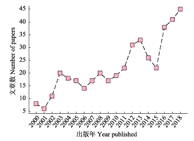
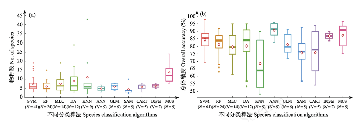

