中国农田土壤动物长期监测样地科学调查监测的实施方法
高梅香, 刘启龙, 朱家祺, 赵博宇, 杜嘉, 吴东辉
生物多样性
2022, 30 ( 1):
21265-.
DOI: 10.17520/biods.2021265
我国农田土壤动物面临严峻的多样性丧失问题, 建设监测样地并开展长期监测是解决该问题的重要途径, 但至今国内外仍缺乏农田土壤动物长期监测样地科学调查监测的实施方法。依据BCI 50 ha大型固定样地建设规范, 参照我国已建成的森林和农田土壤动物大型固定样地监测经验, 本文提出了农田土壤动物长期监测样地科学调查监测的实施方法。首先, 需要明确科学问题, 确定科学调查监测应遵守的基本原则。其次, 需要规范长期调查监测涉及的专业术语, 依据研究目的和实际情况选择地点和样地, 参照建设规范和农田特征建立农田土壤动物大型固定样地。第三, 以研究农田土壤动物多样性为核心, 揭示土壤动物在农田生态系统健康和功能中的作用, 有选择性地开展4类27项科学指标的长期监测工作, 要求按照统一的、规范化的工作流程开展野外调查和室内实验。最后, 要科学规范地完成标本的鉴定描述和保存保管, 研发体现农田土壤动物特征的数据库和管理信息系统。希望本文的研究结果能推动我国乃至世界范围的规范化样地建设和标准化网络监测, 为我国农田土壤动物评估与保护提供长期可靠的数据支撑。
类别
Type | 序号 No. | 监测对象
Monitoring object | 监测指标
Index | 获取途径
Acquiring source | 调查必要性 Necessity of investigation | | I | 1 | 土壤动物群落物种组成 Species composition of soil animal community | 土壤动物物种名录
Species list of soil animal community | 野外取样和室内分析 Field sampling and laboratory analysis | 必须 Essential | | 2 | 土壤动物多度 Soil animal abundance | 生物量和密度 Biomass and density | 野外取样和室内分析 Field sampling and laboratory analysis | 必须 Essential | | 3 | 物种功能性状 Species functional trait | 体长、体宽、翅长等 Length, width, wing length, etc. (依据不同类群特征确定 Selecting according to the characteristics of target group) | 野外取样、室内分析、文献检索 Field sampling, laboratory analysis and literature retrieval | 必须 Essential | | 4 | 多样性 Diversity | α多样性、β多样性、γ多样性、物种丰富度、物种均匀度、功能多样性、遗传多样性 α diversity, β diversity, γ diversity, species richness, species evenness, functional diversity and genetic diversity | 计算分析 Calculation and analysis | 必须 Essential | | II | 5 | 微生物多样性 Microbial diversity | 分类操作单元 Operational taxonomic units (OTUs) | 野外取样和室内分析 Field sampling and laboratory analysis | 可选 Selectable | | 6 | 啮齿动物多样性 Rodent diversity | 物种数、个体数、生物量、活动时间、物种多样性指数、功能性状指数等 Species richness, individual, biomass, activity time, species diversity index, functional trait index, etc. | 野外调查和社会调研 Field sampling and social investigation | 可选 Selectable | | 7 | 植株上的昆虫多样性 Insect diversity in plant | 物种数、个体数、物种多样性指数、功能性状指数等 Species richness, individual, species diversity index, functional trait index, etc. | 野外取样和室内分析 Field sampling and laboratory analysis | 可选 Selectable | | 8 | 鸟类多样性 Bird diversity | 物种数、个体数、生物量、活动时间、物种多样性指数、功能性状指数等 Species richness, individual, biomass, activity time, species diversity index, functional trait index, etc. | 野外取样和室内分析 Field sampling and laboratory analysis | 可选 Selectable | | 9 | 蝴蝶多样性 Butterfly diversity | 物种数、个体数、生物量、活动时间、物种多样性指数、功能性状指数等 Species richness, individual, biomass, activity time, species diversity index, functional trait index, etc. | 野外取样, 室内分析 Field sampling and laboratory analysis | 可选 Selectable | | 10 | 授粉者多样性 Pollinator diversity | 物种数、个体数、生物量、活动时间、物种多样性指数、功能性状指数等 Species richness, individual, biomass, activity time, species diversity index, functional trait index, etc. | 野外取样, 室内分析 Field sampling and laboratory analysis | 可选 Selectable | | 11 | 害虫多样性 Pest diversity | 物种数、个体数、生物量、活动时间、物种多样性指数、功能性状指数等 Species richness, individual, biomass, activity time, species diversity index, functional trait index, etc. | 野外取样和室内分析 Field sampling and laboratory analysis | 可选 Selectable | | III | 12 | 土壤碳、氮、磷储量 Carbon, nitrogen and phosphorus reserves in soil | 土壤碳、氮、磷含量 Soil carbon, nitrogen and phosphorus content | 野外取样和室内分析 Field sampling and laboratory analysis | 必须 Essential | | 13 | 土壤养分 Soil nutrient | 全氮、全磷、全钾、速效氮、速效磷、速效钾、pH等 Total N, total P, total K, available N, available P, available K, soil pH, etc. | 野外取样、室内分析、台站共享、 无人机遥感等 Field sampling, laboratory analysis, data share by ecological station, unmanned aerial remote sensing, etc. | 必须 Essential | | 14 | 土壤微量元素和重金属元素 Trace element and heavy metal element in soil | 全锰、有效锰、全锌、有效锌、全铜、有效铜、全铁、 有效铁等 Total Mn, available Mn, total Zn, available Zn, total Cu, available Cu, total Fe, available Fe, etc. | 野外取样、室内分析、台站共享等 Field sampling, laboratory analysis, data share by ecological station, etc. | 可选 Selectable | | 15 | 土壤物理性质 Soil physical property | 土壤类型、质地、孔隙度、含水量、容重、机械组成、 土层深度等 Soil type, texture, porosity, water content, bulk density, mechanical composition, soil depth, etc. | 野外取样、室内分析、台站共享、 无人机遥感等 Field sampling, laboratory analysis, data share by ecological station, unmanned aerial remote sensing, etc. | 必须 Essential | | 16 | 土壤速效微量元素 Soil available trace element | 有效铁、有效铜、有效锰、有效锌等 Available Fe, available Cu, available Mn, available Zn, etc. | 野外取样、室内分析、台站共享等 Field sampling, laboratory analysis, data share by ecological station, etc. | 可选 Selectable | | 17 | 土壤可溶性盐 Soil soluble salt | 碳酸根、重碳酸根、硫酸根、氯根、钙离子、镁离子、 钾离子、钠离子、全盐量、电导率等 Carbonate, bicarbonate, sulfate radical, chloride, calcium ion, magnesium ion, potassium ion, sodium ion, total salt content, conductivity, etc. | 野外取样、室内分析、台站共享等 Field sampling, laboratory analysis, data share by ecological station, etc. | 可选 Selectable | | 18 | 农作物基本要素 Basic element of crop | 作物种类、名称、品种、播种面积、单产、总产、产值、根部生物量、农田的复种指数、轮作体系等 Crop type, name, variety, sown area, yield, total yield, production value, root biomass, multiple cropping index of farmland, rotation system, etc. | 野外取样、室内分析、台站共享, 无人机遥感等 Field sampling, laboratory analysis, data share by ecological station, unmanned aerial remote sensing, etc. | 必须 Essential | | 19 | 空间坐标 Space coordinates | 样地的空间坐标、样品的空间坐标 Space coordinates of the site, space coordinates of the sample | 野外测量 Field survey | 必须 Essential | | 20 | 地形因素 Topographic factor | 海拔、坡向、坡度、地表起伏度等 Elevation, aspect, slope, relief degree of land surface, etc. | 现场勘测和DEM数据计算获得 Site survey and calculation from DEM data | 必须 Essential | | 21 | 土地利用 Land use | 土地利用类型、强度、历史等 Land use type, intensity, history, etc. | 遥感、社会调查、文献检索 Remote sensing, social survey and document retrieval | 必须 Essential | | 22 | 景观因素 Landscape factor | 斑块面积、斑块密度、景观分离指数、Shannon多样性指数 Patch area, patch density, landscape separation index and Shannon’s diversity index | 遥感 Remote sensing | 可选 Selectable | | 23 | 地史进化因素 Geographical evolution factor | 地质历史和进化历史 Geological and evolutionary history | 文献检索和谱系分析 Document retrieval and phylogenetic analysis | 可选 Selectable | | IV | 24 | 社会经济因素 Socioeconomic factor | 人口数量、生活来源、人均收入、学校数量、人口老龄化指标等 Population size, source of income, per capita income, no. of schools, population aging indicators, etc. | 社会调研、年鉴统计、资料检索 Social investigation, statistical yearbook and document retrieval | 必须 Essential | | 25 | 肥料投入情况 Fertilizer inputs | 施用肥料名称、作物生育时期、施用日期、施用方式、 施用量、含氮量、含磷量、含钾量等 Name of fertilizer, crop growth period, application date, application method, application amount, nitrogen content, phosphorus content, potassium content, etc. | 野外采样和台站共享 Field sampling and data share by ecological station | 必须 Essential | | 26 | 农药、除草剂、生长剂投入情况 Inputs of pesticide, herbicide, growth promoter | 施用药剂名称、主要有效成分、施用日期、施用量, 施用方式等 Drug name, main active ingredient, application date, application amount, application method, etc. | 野外采样和台站共享 Field sampling and data share by ecological station | 必须 Essential | | 27 | 灌溉制度 Irrigation system | 灌溉时间、作物生育期、灌溉水源、灌溉方式、灌溉水量等 Irrigation time, crop growth period, irrigation water source, irrigation method, irrigation water volume, etc. | 野外采样, 台站共享 Field sampling and data share by ecological station | 必须 Essential |
View table in article
表2
农田土壤动物长期监测样地中的获取指标
正文中引用本图/表的段落
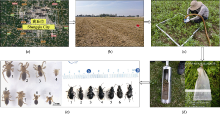
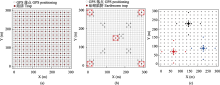
(2)测量样地和布置地面控制点。选择样地的1个顶点(如西南角顶点)作为该样地的坐标原点, 记为O点(0, 0), 实地测量该原点的地理坐标、海拔高度、周围地形特征等数据。农田土壤动物大型固定样地至少需测量4个地面控制点, 包括3个永久和1个备用地面控制点。精确地选择和布置地面控制点,既是样地长期监测过程中再放样的精准参照, 也是对全球所有样地进行精准定位和大尺度分析的关键信息。地面控制点可以作为样地的永久地标, 建议布设在大型固定样地的外围, 最好同时具备地物标记明显、不易发生变动、容易寻找和再定位的典型特征。使用经纬仪和RTK精准确定每个地面控制点的坐标, 然后做永久标记。可以采用以下几种方法永久标记地面控制点: (1)将永久地标埋设于地表。在地下挖出大小合适的土坑, 埋设用来做标记的水泥桩, 在露出地面的水泥桩上进行地理标记。该方法的缺点是过于明显, 若影响到当地人的正常生产活动, 很容易被当地农民移除。(2)将永久地标埋设于地下。在地下挖取1 m深的土坑, 然后灌注满水泥, 待稍干后进行地理标记。其优点是不易被发现, 但若是遇到当地农户更改土地利用方式, 该地标也会被发现、破坏和移除。(3)使用干石灰做标记, 俗称灰桩。使用土钻打出深度为1 m的土坑, 在土坑内灌满粉末状干石灰。优点是标记时间持久, 即便是上层土壤被挖取或移除(只要深度不超过1 m), 下层石灰仍可起到永久标记的作用(附录2)。
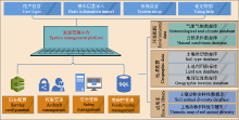
根据农田土壤动物长期监测样地的总体目标和拟解决的科学问题, 我们提出一个以农田土壤动物多样性为核心, 兼顾土壤动物在农田生态系统健康和功能中作用, 包括4类27项具体指标的监测指标体系(表2)。表2中, I是农田土壤动物多样性野外调查内容和监测指标, 其目的是获取物种和功能多样性指标, 其调查必要性均为必选; II是农田生态系统健康和关键生态系统功能指标, 其目的是获取土壤动物与农田健康和功能紧密相关的重要指标, 其调查必要性均为可选, 可依据研究目的选择是否长期监测; III是关键环境因子指标, 其目的是获取与土壤动物多样性维持、功能作用等相关的自然环境指标, 其调查必要性为必选和可选; IV为人类管理行为和社会经济影响指标, 其目的是获取土壤动物对人类活动响应相关的指标, 因为农田土壤动物受人类活动的强烈干扰和影响, 所以这些指标为必选。
(2)根据调查方案采集样品。可使用土柱法、陷阱法采集中小型土壤动物, 手拣法、筛网法采集大型土壤动物, 陷阱法、诱捕法、吸虫器法等采集地表节肢动物。同时采集表2中列举的调查必要性为“必须”的指标, 可根据研究目的有选择地调查必要性为“可选”的指标。
本文的其它图/表
|