
生物多样性 ›› 2021, Vol. 29 ›› Issue (4): 531-544. DOI: 10.17520/biods.2020176 cstr: 32101.14.biods.2020176
胡文佳1,3, 周秋麟1, 陈彬1,3,*( ), 杨圣云2, 肖佳媚2, 杜建国1,3, 黄浩1,3, 俞炜炜1,3, 马志远1,3
收稿日期:2020-04-29
接受日期:2020-08-18
出版日期:2021-04-20
发布日期:2021-04-20
通讯作者:
陈彬
基金资助:
Wenjia Hu1,3, Qiulin Zhou1, Bin Chen1,3,*(), Shengyun Yang2, Jiamei Xiao2, Jianguo Du1,3, Hao Huang1,3, Weiwei Yu1,3, Zhiyuan Ma1,3
Received:2020-04-29
Accepted:2020-08-18
Online:2021-04-20
Published:2021-04-20
Contact:
Bin Chen
About author:* E-mail: chenbin@tio.org.cn摘要:
基于生态系统的海洋管理采用生态边界而非行政边界来指导管理实践, 海洋生境制图旨在探寻海洋环境与生物群落/物种的分布规律, 从而为生物多样性保护和海洋空间规划等管理行动提供可以依循的生态边界。海洋生境制图是科研监测数据通往管理决策应用的有效途径, 近年来已成为海洋生态保护与管理领域的国际研究热点, 但我国对于海洋生境制图的研究才刚刚起步。本文对海洋生境制图的国内外研究进展进行了综述, 介绍了海洋生境制图的定义和内涵, 明确了海洋生境制图的步骤及其在生态系统管理中的应用; 系统阐述了海洋生境制图的主要研究方法, 从生境分类方案、生境分区和生态特征描述等方面对海洋生境制图的研究过程及采用的分析方法进行了总结; 全面梳理了国内外的代表性海洋生境制图研究案例, 对各国已开发的海洋生境分类分区体系进行了对比和评述, 总结了共性特征; 最后提出研究建议, 对我国开展海洋生境制图研究的前景进行展望, 以期为我国的海洋生态空间管理工作提供科学依据和参考。
胡文佳, 周秋麟, 陈彬, 杨圣云, 肖佳媚, 杜建国, 黄浩, 俞炜炜, 马志远 (2021) 海洋生境制图研究进展: 概念、方法与应用. 生物多样性, 29, 531-544. DOI: 10.17520/biods.2020176.
Wenjia Hu, Qiulin Zhou, Bin Chen, Shengyun Yang, Jiamei Xiao, Jianguo Du, Hao Huang, Weiwei Yu, Zhiyuan Ma (2021) Progress in marine habitat mapping: Concept, methods, and applications. Biodiversity Science, 29, 531-544. DOI: 10.17520/biods.2020176.
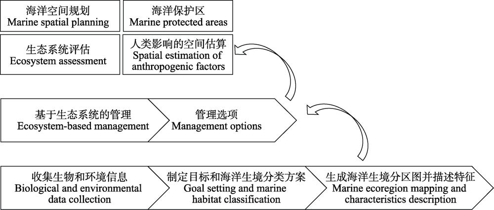
图1 海洋生境制图及应用步骤
Fig. 1 Stages of marine habitat mapping and application
| 产品 Product | 方法 Methodology | 采用的数据和信息 Utilized data and information | 来源 Sources | ||
|---|---|---|---|---|---|
| 大洋生物地理边界图 Pelagic biogeography boundaries | 专家意见 Expert opinion | 文献资料 Previous literature | van der Spoel, 1994 | ||
| 大海洋生态系内的渔业区划 Fishery regions in Large Marine Ecosystems | 现有文献整合 Synthesizing previous work | 大海洋生态系和出版物 Large Marine Ecosystem and publications | Watson et al, | ||
| 大洋表层生态分区(不包括海岸带) Surface pelagic zones, not coastal | 专家意见 Expert opinion | 海洋水色和理化数据 Ocean color and physio-chemical data | Longhurst, | ||
| 世界海洋生态区系统 Coastal marine ecoregions of the world | 专家意见 Expert opinion | 已有的各区域的海岸带分区的综合资料 Previous regional coastal mapping | Spalding et al, | ||
| 基于叶绿素a的海洋中上层生物群落分类分区 Classification of biomes based on chlorophyll-a in pelagic ocean | 层次聚类分析 Hierarchical cluster analysis | 月均叶绿素a Mean monthly chlorophyll-a content | Hardman-Mountford et al. 2008 | ||
| 全球海洋生物地理省分区 Global ocean biogeographic provinces | 多元聚类分析 Multivariate cluster analysis | MODIS/Aqua衍生的海表温度和海洋水色数据 Sea surface temperature and ocean color from MODIS/Aqua reprocessing | Oliver & Irwin, | ||
| 全球大洋和深海海底分区 Global open oceans and deep seabed classification | 专家意见 Expert opinion | 现有研究的综述 Review of previous studies | UNESCO, | ||
| 为全球公海海洋保护区设计的海洋底栖生境图 Global benthic seascapes for high seas marine protected areas | 多元分析 Multivariate analysis | 水深、斜坡、初级生产力、沉积物厚度、底层 温度、底层溶解氧 Depth, slope, net primary productivity, sediment thickness, bottom temperature, and bottom dissolved oxygen | Harris & Whiteway, | ||
| 全球深海(> 800 m)生物省分区 Biogeographic provinces for deep ocean floor (> 800 m) | 专家意见 Expert opinion | 指示深海生物分布的理化变量 Physical and chemical variables indicating organism distribution at the deep-sea floor | Watling et al, | ||
| 大洋浮游生物多样性热点区 Oceanic phytoplankton hotspot regions | Shannon熵值法 Shannon entropy | 海洋水色遥感 Remote sensing of ocean color | Silvia et al. 2013 | ||
| 大洋生态区 Ecoregions of ocean | 表层海流分带 Sea surface currents classification | 海流, 包括水温、盐度和上升流 Ocean currents, including temperature, salinity, and upwellings | Bailey, | ||
| 海洋动植物的生物地理带分区 Biogeographic realms of marine animals and flora | 物种出现数据的标准化聚类分析 Standardized cluster analysis of species occurrence data | 中上层和底栖生物分布数据 Pelagic and benthic species distribution data | Costello et al, | ||
| 海洋水体的三维生态单元分区Three-dimensional ecological marine units | K-均值聚类分析 K-means clustering analysis | 水温、盐度、溶解氧、硝酸盐、磷酸盐和硅酸 盐的三维环境变量 Three-dimensional environmental variables of temperature, salinity, oxygen, nitrate, phosphate, and silicate | Sayre et al, | ||
| 全球大洋中层生物地球化学分区 Global mesopelagic biogeochemical provinces | 多元聚类分析和边界频次 Multivariate cluster analysis and boundary frequency | 世界大洋地图的中层环境数据 Mesopelagic environmental data from World Ocean Atlas | Reygondeau et al. | ||
| 世界海洋生态系统聚类分区 Clustered marine ecosystems of the world ocean | 主成分分析和K-均值聚类分析 Principal component analysis and K-means clustering analysis | 20项海洋环境变量 20 environmental variables | Zhao et al, | ||
表1 全球海洋生境分区研究及方法总结(修改自Zhao & Costello, 2019)
Table 1 Global marine habitat classifications and methods (Modified from Zhao & Costello, 2019)
| 产品 Product | 方法 Methodology | 采用的数据和信息 Utilized data and information | 来源 Sources | ||
|---|---|---|---|---|---|
| 大洋生物地理边界图 Pelagic biogeography boundaries | 专家意见 Expert opinion | 文献资料 Previous literature | van der Spoel, 1994 | ||
| 大海洋生态系内的渔业区划 Fishery regions in Large Marine Ecosystems | 现有文献整合 Synthesizing previous work | 大海洋生态系和出版物 Large Marine Ecosystem and publications | Watson et al, | ||
| 大洋表层生态分区(不包括海岸带) Surface pelagic zones, not coastal | 专家意见 Expert opinion | 海洋水色和理化数据 Ocean color and physio-chemical data | Longhurst, | ||
| 世界海洋生态区系统 Coastal marine ecoregions of the world | 专家意见 Expert opinion | 已有的各区域的海岸带分区的综合资料 Previous regional coastal mapping | Spalding et al, | ||
| 基于叶绿素a的海洋中上层生物群落分类分区 Classification of biomes based on chlorophyll-a in pelagic ocean | 层次聚类分析 Hierarchical cluster analysis | 月均叶绿素a Mean monthly chlorophyll-a content | Hardman-Mountford et al. 2008 | ||
| 全球海洋生物地理省分区 Global ocean biogeographic provinces | 多元聚类分析 Multivariate cluster analysis | MODIS/Aqua衍生的海表温度和海洋水色数据 Sea surface temperature and ocean color from MODIS/Aqua reprocessing | Oliver & Irwin, | ||
| 全球大洋和深海海底分区 Global open oceans and deep seabed classification | 专家意见 Expert opinion | 现有研究的综述 Review of previous studies | UNESCO, | ||
| 为全球公海海洋保护区设计的海洋底栖生境图 Global benthic seascapes for high seas marine protected areas | 多元分析 Multivariate analysis | 水深、斜坡、初级生产力、沉积物厚度、底层 温度、底层溶解氧 Depth, slope, net primary productivity, sediment thickness, bottom temperature, and bottom dissolved oxygen | Harris & Whiteway, | ||
| 全球深海(> 800 m)生物省分区 Biogeographic provinces for deep ocean floor (> 800 m) | 专家意见 Expert opinion | 指示深海生物分布的理化变量 Physical and chemical variables indicating organism distribution at the deep-sea floor | Watling et al, | ||
| 大洋浮游生物多样性热点区 Oceanic phytoplankton hotspot regions | Shannon熵值法 Shannon entropy | 海洋水色遥感 Remote sensing of ocean color | Silvia et al. 2013 | ||
| 大洋生态区 Ecoregions of ocean | 表层海流分带 Sea surface currents classification | 海流, 包括水温、盐度和上升流 Ocean currents, including temperature, salinity, and upwellings | Bailey, | ||
| 海洋动植物的生物地理带分区 Biogeographic realms of marine animals and flora | 物种出现数据的标准化聚类分析 Standardized cluster analysis of species occurrence data | 中上层和底栖生物分布数据 Pelagic and benthic species distribution data | Costello et al, | ||
| 海洋水体的三维生态单元分区Three-dimensional ecological marine units | K-均值聚类分析 K-means clustering analysis | 水温、盐度、溶解氧、硝酸盐、磷酸盐和硅酸 盐的三维环境变量 Three-dimensional environmental variables of temperature, salinity, oxygen, nitrate, phosphate, and silicate | Sayre et al, | ||
| 全球大洋中层生物地球化学分区 Global mesopelagic biogeochemical provinces | 多元聚类分析和边界频次 Multivariate cluster analysis and boundary frequency | 世界大洋地图的中层环境数据 Mesopelagic environmental data from World Ocean Atlas | Reygondeau et al. | ||
| 世界海洋生态系统聚类分区 Clustered marine ecosystems of the world ocean | 主成分分析和K-均值聚类分析 Principal component analysis and K-means clustering analysis | 20项海洋环境变量 20 environmental variables | Zhao et al, | ||
| 序号 Number | 特征名称 Name | 特征描述 Description |
|---|---|---|
| 1 | 分级化 Hierarchical | 分类系统应该是分级的, 以避免定义的重叠以及在系统不同层次上出现类别重复, 并确保在生态上相似的类型彼此接近并处于恰当的级别。The classification system should be hierarchical to avoid overlap of definitions and duplication of categories at different levels of the system, and ensure that ecologically similar types are placed near to each other and at an appropriate level. |
| 2 | 互斥性 Exclusive | 分类方案应互斥且详尽, 每个要分类的要素都应仅属于一个类。A classification scheme should be mutually exclusive and exhaustive so that every feature to be classified should fall within one class only. |
| 3 | 全面性 Comprehensive | 全面考虑制图区域内的所有海洋生境类型。Be comprehensive, accounting for all the marine habitats within the mapping region. |
| 4 | 可识别性和重复性 Identifiable and repeatable | 生境应该是可识别的、有重复性的环境单元类型。Habitats should be identifiable, repeatable environmental units. |
| 5 | 可描述性 Descriptive | 可提供通用且易于理解的语言来描述海洋生境。Provide a common and easily understood language for the description of marine habitats. |
| 6 | 易用性 Practical | 形式实用, 表述清晰。Be practical in format and clear in its presentation. |
| 7 | 通用性 Versatility | 保证各种生境采样技术都能产生相同的生境类别或群落定义, 尽管生境分类分区的等级可能取决于采样技术的分辨率。All types of sampling techniques should result in the same habitat classes or community definitions, although the level to which a habitat can be classified in a hierarchy will be dependent on the resolution of the sampling technique. |
| 8 | 动态性 Dynamic | 分类体系应能识别动态的时间尺度。与在较长时间范围内变化的生境因子(例如礁岩)相比, 在较短时间范围内变化的生境因子(例如生物群落)应纳入在层次分类体系中的较低级别。The classification should recognize time scales over which variables may change. Habitat variables that change over shorter time scales (e.g. biota) should be incorporated at a lower level in the hierarchy than variables that change over longer time scales (e.g. reef substratum). |
| 9 | 普遍性 Universality | 它应包括足够的细节, 以供自然资源管理人员和监测人员应用; 但也应足够宽泛(通过层次结构), 以使宏观的生境信息能够在国家和全球层面上呈现或供非专业人员使用。It should include sufficient detail to be of practical use for resource managers and field surveyors, but be sufficiently broad (through hierarchical structuring) to enable summary habitat information to be presented at national and international levels or be used by nonspecialists. |
| 10 | 可扩展性 Scalable | 它应该足够灵活, 能够通过添加新信息进行修改, 但又要足够稳定以支持正在进行的应用。修改的内容可以被清晰地记录, 有可能的话可将新定义的类型重新关联到之前的分类体系中。It should be sufficiently flexible to enable modification resulting from the addition of new information, but stable enough to support ongoing uses. Changes should be clearly documented and where possible, newly defined types need to be related back to types in earlier versions of the classification. |
表2 海洋生境分类方案特征列表(修改自Ball et al, 2006)
Table 2 Characteristics of marine habitat classification (Modified from Ball et al, 2006)
| 序号 Number | 特征名称 Name | 特征描述 Description |
|---|---|---|
| 1 | 分级化 Hierarchical | 分类系统应该是分级的, 以避免定义的重叠以及在系统不同层次上出现类别重复, 并确保在生态上相似的类型彼此接近并处于恰当的级别。The classification system should be hierarchical to avoid overlap of definitions and duplication of categories at different levels of the system, and ensure that ecologically similar types are placed near to each other and at an appropriate level. |
| 2 | 互斥性 Exclusive | 分类方案应互斥且详尽, 每个要分类的要素都应仅属于一个类。A classification scheme should be mutually exclusive and exhaustive so that every feature to be classified should fall within one class only. |
| 3 | 全面性 Comprehensive | 全面考虑制图区域内的所有海洋生境类型。Be comprehensive, accounting for all the marine habitats within the mapping region. |
| 4 | 可识别性和重复性 Identifiable and repeatable | 生境应该是可识别的、有重复性的环境单元类型。Habitats should be identifiable, repeatable environmental units. |
| 5 | 可描述性 Descriptive | 可提供通用且易于理解的语言来描述海洋生境。Provide a common and easily understood language for the description of marine habitats. |
| 6 | 易用性 Practical | 形式实用, 表述清晰。Be practical in format and clear in its presentation. |
| 7 | 通用性 Versatility | 保证各种生境采样技术都能产生相同的生境类别或群落定义, 尽管生境分类分区的等级可能取决于采样技术的分辨率。All types of sampling techniques should result in the same habitat classes or community definitions, although the level to which a habitat can be classified in a hierarchy will be dependent on the resolution of the sampling technique. |
| 8 | 动态性 Dynamic | 分类体系应能识别动态的时间尺度。与在较长时间范围内变化的生境因子(例如礁岩)相比, 在较短时间范围内变化的生境因子(例如生物群落)应纳入在层次分类体系中的较低级别。The classification should recognize time scales over which variables may change. Habitat variables that change over shorter time scales (e.g. biota) should be incorporated at a lower level in the hierarchy than variables that change over longer time scales (e.g. reef substratum). |
| 9 | 普遍性 Universality | 它应包括足够的细节, 以供自然资源管理人员和监测人员应用; 但也应足够宽泛(通过层次结构), 以使宏观的生境信息能够在国家和全球层面上呈现或供非专业人员使用。It should include sufficient detail to be of practical use for resource managers and field surveyors, but be sufficiently broad (through hierarchical structuring) to enable summary habitat information to be presented at national and international levels or be used by nonspecialists. |
| 10 | 可扩展性 Scalable | 它应该足够灵活, 能够通过添加新信息进行修改, 但又要足够稳定以支持正在进行的应用。修改的内容可以被清晰地记录, 有可能的话可将新定义的类型重新关联到之前的分类体系中。It should be sufficiently flexible to enable modification resulting from the addition of new information, but stable enough to support ongoing uses. Changes should be clearly documented and where possible, newly defined types need to be related back to types in earlier versions of the classification. |
| [1] | Allee RJ, Dethier M, Brown D, Deegan L, Ford RG, Hourigan TF, Maragos J, Schoch C, Sealey K, Twilley R, Weinstein MP, Yoklavich M (2000) Marine and Estuarine Ecosystem and Habitat Classification. NOAA/National Marine Fisheries Service, Silver Spring, MD. |
| [2] | Bailey RG (2014) Ecoregions: The Ecosystem Geography of the Oceans and Continents. Springer, New York. |
| [3] | Ball D, Blake S, Plummer A (2006) Review of Marine Habitat Classification Systems. Parks Victoria, Melbourne, Australia. |
| [4] | Beck MW, Brumbaugh RD, Airoldi L, Carranza A, Coen LD, Crawford C, Defeo O, Edgar GJ, Hancock B, Kay MC, Lenihan HS, Luckenbach MW, Toropova CL, Zhang GF, Guo XM (2011) Oyster reefs at risk and recommendations for conservation, restoration, and management. BioScience, 61,107-116. |
| [5] | Bekkby T, Gerovasileiou V, Papadopoulou KN, Sevastou K, Dailianis T, Fiorentino D, McOwen C, Smith CJ, Amaro T, Bakran-Petricioli T, Bilan M, Boström C, Carreiro-Silva M, Carugati L, Cebrian E, Cerrano C, Christie H, Danovaro R, Eronat EGT, Fraschetti S, Gagnon K, Gambi C, Grehan A, Hereu B, Kipson S, Kizilkaya IT, Kotta J, Linares C, Milanese M, Morato T, Ojaveer H, Orav-Kotta H, Pham CK, Rinde E, Sarà A, Scharfe M, Scrimgeour R (2017) State of the Knowledge on European Marine Habitat Mapping and Degraded Habitats. http://www.merces-project.eu/sites/def ault/files/MERCES_D1.1_0.pdf. (accessed on 2020-03-01) |
| [6] | Bland LM, Keith DA, Miller RM, Murray NJ, Rodríguez JP (2017) Guidelines for the Application of IUCN Red List of Ecosystems Categories and Criteria, Version 1.1. IUCN, Gland, Switzerlands. |
| [7] | Boswarva K, Butters A, Fox CJ, Howe JA, Narayanaswamy B (2018) Improving marine habitat mapping using high-resolution acoustic data; a predictive habitat map for the Firth of Lorn, Scotland. Continental Shelf Research, 168,39-47. |
| [8] | Brown CJ, Smith SJ, Lawton P, Anderson JT (2011) Benthic habitat mapping: A review of progress towards improved understanding of the spatial ecology of the seafloor using acoustic techniques. Estuarine, Coastal and Shelf Science, 92,502-520. |
| [9] | Buhl-Mortensen L, Buhl-Mortensen P, Dolan MJF, Gonzalez- Mirelis G (2015a) Habitat mapping as a tool for conservation and sustainable use of marine resources: Some perspectives from the MAREANO Programme, Norway. Journal of Sea Research, 100,46-61. |
| [10] | Buhl-Mortensen L, Buhl-Mortensen P, Dolan MFJ, Holte B (2015b) The MAREANO programme—A full coverage mapping of the Norwegian off-shore benthic environment and fauna. Marine Biology Research, 11,4-17. |
| [11] | Butler C, Lucieer V, Walsh P, Flukes E, Johnson C (2017) Seamap Australia [Version 1.0] the Development of a National Benthic Marine Classification Scheme for the Australian Continental Shelf. The Institute for Marine and Antarctic Studies, University of Tasmania. |
| [12] | Cameron A, Askew N (2011) EUSeaMap—Preparatory Action for Development and Assessment of a European Broad-Scale Seabed Habitat Map. https://webgate.ec.europa.eu/maritimeforum/system/files/20110301_FinalReport_EUSeaMap_v2.9.pdf. (accessed on 2020-03-01) |
| [13] | Carey DA, Hayn M, Germano JD, Little DI, Bullimore B (2015) Marine habitat mapping of the Milford Haven Waterway, Wales, UK: Comparison of facies mapping and EUNIS classification for monitoring sediment habitats in an industrialized estuary. Journal of Sea Research, 100,99-119. |
| [14] | Carollo C, Allee RJ, Yoskowitz DW (2013) Linking the Coastal and Marine Ecological Classification Standard (CMECS) to ecosystem services: An application to the US Gulf of Mexico. International Journal of Biodiversity Science, Ecosystem Services & Management, 9,249-256. |
| [15] | Chen GL, Hu WJ, Chen B, Ma ZY, Liao JJ (2017) Marine spatial planning using in marine ecological red line zoning—A case study of Dongshan County. Journal of Applied Oceanography, 36,6-15. (in Chinese with English abstract) |
| [ 陈甘霖, 胡文佳, 陈彬, 马致远, 廖建基 (2017) 海洋空间规划技术在小尺度海洋生态红线区划中的应用——以东山县海域为例. 应用海洋学学报, 36,6-15. ] | |
| [16] | Cogan CB, Todd BJ, Lawton P, Noji TT (2009) The role of marine habitat mapping in ecosystem-based management. ICES Journal of Marine Science, 66,2033-2042. |
| [17] | Connor DW, Allen JH, Golding N, Howell KL, Lieberknecht LM, Northen KO, Reker JB (2004) The Marine Habitat Classification for Britain and Ireland, Version 04.05. Joint Nature Conservation Committee, Peterborough, UK. |
| [18] | Costello MJ (2009) Distinguishing marine habitat classification concepts for ecological data management. Marine Ecology Progress Series, 397,253-268. |
| [19] |
Costello MJ, Tsai P, Wong PS, Cheung AKL, Basher Z, Chaudhary C (2017) Marine biogeographic realms and species endemicity. Nature Communications, 8,1057.
DOI URL PMID |
| [20] | Cropper A (1993) Convention on Biological Diversity. Environmental Conservation, 20,364. |
| [21] | Crowder L, Norse E (2008) Essential ecological insights for marine ecosystem-based management and marine spatial planning. Marine Policy, 32,772-778. |
| [22] |
de la Hoz CF, Ramos E, Puente A, Méndez F, Menéndez M, Juanes JA, Losada ÍJ (2018) Ecological typologies of large areas: An application in the Mediterranean Sea. Journal of Environmental Management, 205,59-72.
URL PMID |
| [23] | Diaz RJ, Solan M, Valente RM (2004) A review of approaches for classifying benthic habitats and evaluating habitat quality. Journal of Environmental Management, 73,165-181. |
| [24] | European Commission (2007) Data Completeness, Quality and Coherence. Guidance document on “Habitats Directive”, European Commission. |
| [25] |
Edgar GJ, Stuart-Smith RD, Willis TJ, Kininmonth S, Baker SC, Banks S, Barrett NS, Becerro MA, Bernard ATF, Berkhout J, Buxton CD, Campbell SJ, Cooper AT, Davey M, Edgar SC, Försterra G, Galván DE, Irigoyen AJ, Kushner DJ, Moura R, Parnell PE, Shears NT, Soler G, Strain EMA, Thomson RJ (2014) Global conservation outcomes depend on marine protected areas with five key features. Nature, 506,216-220.
DOI URL PMID |
| [26] | Evans D (2012) The EUNIS habitats classification: Past, present and future. Revista de Investigación Marina, 19,28-29. |
| [27] | Evans D, Condé S, Gelabert ER (2014) Crosswalks between European Marine Habitat Typologies—A Contribution to the MAES Marine Pilot. ETC/BD Report for the EEA. |
| [28] | FGDC (2012) Coastal and Marine Ecological Classification Standard. FGDC-STD-018-2012, United States. |
| [29] | Finck P, Heinze S, Raths U, Riecken U, Ssymank A (2017) Red List of Endangered Biotope Types in Germany—Third Updated Version in 2017. The Federal Agency of Nature Conservation, Berlin. |
| [30] | Fontaine A, Devillers R, Peres-Neto PR, Johnson LE (2015) Delineating marine ecological units: A novel approach for deciding which taxonomic group to use and which taxonomic resolution to choose. Diversity and Distributions, 21,1167-1180. |
| [31] | Gagne TO, Reygondeau G, Jenkins CN, Sexton JO, Bograd SJ, Hazen EL, Van Houtan KS (2020) Towards a global understanding of the drivers of marine and terrestrial biodiversity. PLoS ONE, 15,0228065. |
| [32] | Galparsoro I, Connor DW, Borja A, Aish A, Amorim P, Bajjouk T, Chambers C, Coggan R, Dirberg G, Ellwood H, Evans D, Goodin KL, Grehan A, Haldin J, Howell K, Jenkins C, Michez N, Mo G, Buhl-Mortensen P, Pearce B, Populus J, Salomidi M, Sánchez F, Serrano A, Shumchenia E, Tempera F, Vasquez M (2012) Using EUNIS habitat classification for benthic mapping in European seas: Present concerns and future needs. Marine Pollution Bulletin, 64,2630-2638. |
| [33] | Grant S, Constable A, Raymond B, Doust S (2006) Bioregionalisation of the Southern Ocean. CE-CRC and WWF, Australia. |
| [34] | Gray JS (1997) Marine biodiversity: Patterns, threats and conservation needs. Biodiversity and Conservation, 6,153-175. |
| [35] |
Halpern BS, Frazier M, Potapenko J, Casey KS, Koenig K, Longo C, Lowndes JS, Rockwood RC, Selig ER, Selkoe KA, Walbridge S (2015) Spatial and temporal changes in cumulative human impacts on the world’s ocean. Nature Communications, 6,7615.
URL PMID |
| [36] | Hardman-Mountford NJ, Hirata T, Richardson KA, Aiken J (2008) An objective methodology for the classification of ecological pattern into biomes and provinces for the pelagic ocean. Remote Sensing of Environment, 112,3341-3352. |
| [37] | Harris PT, Baker EK (2020) Why map benthic habitats? Seafloor geomorphology as benthic habitat. In:Seafloor Geomorphology as Benthic Habitat (eds Harris PT, Baker EK), pp.3-22. Elsevier Science. |
| [38] | Harris PT, Whiteway T (2009) High seas marine protected areas: Benthic environmental conservation priorities from a GIS analysis of global ocean biophysical data. Ocean and Coastal Management, 52,22-38. |
| [39] | HELCOM (1998) Red List of Marine and Coastal Biotopes and Biotopes Complexes of the Baltic Sea, Belt Sea and Kattegat. Helsinki Commission, Helsinki, Finland. |
| [40] | HELCOM (2013a) HELCOM HUB—Technical Report on the HELCOM Underwater Biotope and Habitat Classification. Helsinki Commission, Helsinki, Finland. |
| [41] | HELCOM (2013b) Red List of Baltic Sea Underwater Biotopes, Habitats and Biotope Complexes. Helsinki Commission, Helsinki, Finland. |
| [42] | Hu WJ, Chen B, Ma ZY, Yu WW, Xiao JM, Zhang D (2020) The research progress and enlightenment of ecosystem-based marine spatial planning. Ocean Development and Management, 37(4),3-11. (in Chinese with English abstract) |
| [ 胡文佳, 陈彬, 马志远, 俞炜炜, 肖佳媚, 张典 (2020) 基于生态系统的海洋空间规划: 研究进展与启示. 海洋开发与管理, 37(4),3-11. ] | |
| [43] | Huang H, Chen B, Lin JL (2015) The marine spatial classification and the identification of priority conservation areas (PCAs) for marine biodiversity conservation—A case study of the offshore China. Ocean and Coastal Management, 116,224-236. |
| [44] | Huang Z, Brooke BP, Harris PT (2011) A new approach to mapping marine benthic habitats using physical environmental data. Continental Shelf Research, 31,S4-S16. |
| [45] | ICES (2005) Report of the Working Group on Habitat Mapping (WGMHM), p. 87. ICES, Bremerhaven. |
| [46] | ICES (2008) ICES Science Plan, 2009-2013, p. 14. ICES, Copenhagen. |
| [47] | IMCRA (1998) Interim Marine and Coastal Regionalisation for Australia: An Ecosystem-based Classification for Marine and Coastal Environments, Version 3.3. IMCRA Technical Group, Canberra. |
| [48] | Katsanevakis S, Stelzenmüller V, Andy S, Sørensen TK, Jones PJS, Kerr S, Badalamenti F, Anagnostou C, Breen P, Chust G, D’Anna G, Duijn M, Filatova T, Fiorentino F, Hulsman H, Johnson K, Karageorgis AP, Kröncke I, Mirto S, Pipitone C, Portelli S, Qiu WF, Reiss H, Sakellariou D, Salomidi M, van Hoof L, Vassilopoulou V, Fernández TV, Vöge S, Weber A, Zenetos A, ter Hofstede ter Hofstede (2011) Ecosystem-based marine spatial management: Review of concepts, policies, tools, and critical issues. Ocean and Coastal Management, 54,807-820. |
| [49] | Keefer ML, Peery CA, Wright N, Daigle WR, Caudill CC, Clabough TS, Griffith DW, Zacharias MA (2008) Evaluating the NOAA Coastal and Marine Ecological Classification Standard in estuarine systems: A Columbia River Estuary case study. Estuarine, Coastal and Shelf Science, 78,89-106. |
| [50] | Livingstone TC, Harris JM, Lombard AT, Smit AJ, Schoeman DS (2018) Classification of marine bioregions on the east coast of South Africa. African Journal of Marine Science, 40,51-65. |
| [51] | Longhurst A (2007) Ecological Geography of the Sea. Academic Press, Boston. |
| [52] | Madden CJ, Grossman DH (2004) Coastal/Marine Systems of North America: Framework for an Ecological Classification Standard. NatureServe, Arlington, Virginia. |
| [53] | Malcolm HA, Jordan A, Schultz AL, Smith SDA, Ingleton T, Foulsham E, Linklater M, Davies P, Ferrari R, Hill N, Lucieer V (2016) Integrating seafloor habitat mapping and fish assemblage patterns improves spatial management planning in a marine park. Journal of Coastal Research, 75,1292-1296. |
| [54] |
McGowan J, Hines E, Elliott M, Howar J, Dransfield A, Nur N, Jahncke J (2013) Using seabird habitat modeling to inform marine spatial planning in central California’s National Marine Sanctuaries. PLoS ONE, 8,e71406.
URL PMID |
| [55] | McLeod KL, Lubchenco J, Palumbi SR, Rosenberg AA (2005) Scientific Consensus Statement on Marine Ecosystem-based Management, USA. https://marineplanning.org/wp-content/uploads/2015/07/Consensusstatement.pdf. (accessed on 2020-03-21) |
| [56] |
Mittermayr A, Legare B, Borrelli M (2020) Applications of the Coastal and Marine Ecological Classification Standard (CMECS) in a Partially Restored New England Salt Marsh Lagoon. Estuaries and Coasts, doi: 10.1007/s12237-020-00707-2.
URL PMID |
| [57] |
Monte SD, Soccodato A, Alvain S, d’Ovidio F (2013) Can we detect oceanic biodiversity hotspots from space? The ISME Journal, 7,2054.
DOI URL PMID |
| [58] | Moss D (2008) EUNIS Habitat Classification—A Guide for Users. European Topic Centre on Biological Diversity. |
| [59] | Mumby PJ, Harborne AR (1999) Development of a systematic classification scheme of marine habitats to facilitate regional management and mapping of Caribbean coral reefs. Biological Conservation, 88,155-163. |
| [60] | Oliver MJ, Irwin AJ (2008) Objective global ocean biogeographic provinces. Geophysical Research Letters, 35,L15601. |
| [61] | Parry MEV (2019) Guidance on Assigning Benthic Biotopes using EUNIS or the Marine Habitat Classification of Britain and Ireland. JNCC, Peterborough. |
| [62] | Populus J, Vasquez M, Albrecht J, Manca E, Agnesi S, Al Hamdani Z, Andersen J (2017) EUSeaMap, a European Broad-scale Seabed Habitat Map. https://doi.org/10.13155/49975. (accessed on 2020-03-21) |
| [63] | Ramos E, Puente A, Guinda X, Juanes JA (2017) A hierarchical ecological classification system along the NE Atlantic coast: Focusing on the local scale (Cantabria, N Spain). European Journal of Phycology, 52,75-89. |
| [64] | Reygondeau G, Guidi L, Beaugrand G, Henson SA, Koubbi P, Mackenzie BR, Sutton TT, Fioroni M, Maury O (2018) Global biogeochemical provinces of the mesopelagic zone. Journal of Biogeography, 45,500-514. |
| [65] | Robinson CLK, Levings CD (1995) An overview of habitat classification systems, ecological models, and geographic information systems applied to shallow foreshore marine habitats. British Journal of Criminology, 7,3-10. |
| [66] | Roff JC, Taylor ME (2000) National frameworks for marine conservation—A hierarchical geophysical approach. Aquatic Conservation Marine and Freshwater Ecosystems, 10,209-223. |
| [67] | Sayre RG, Wright DJ, Breyer SP, Butler KA, Van Graafeiland K, Costello MJ, Harris PT, Goodin KL, Guinotte JM, Basher Z, Kavanaugh MT, Halpin PN, Monaco ME, Cressie N, Aniello P, Frye CE, Stephens D (2017) A three-dimensional mapping of the ocean based on environmental data. Oceanography, 30,90-103. |
| [68] | Schiele KS, Darr A, Zettler ML (2014) Verifying a biotope classification using benthic communities—An analysis towards the implementation of the European Marine Strategy Framework Directive. Marine Pollution Bulletin, 78,181-189. |
| [69] | Schiele KS, Darr A, Zettler ML, Friedland R, Tauber F, von Weber M, Voss J (2015) Biotope map of the German Baltic Sea. Marine Pollution Bulletin, 96,127-135. |
| [70] | Sotheran I, Benson A, Crawford-Avis O (2014) Mapping Habitats and Biotopes from Acoustic Datasets to Strengthen the Information Base of Marine Protected Areas in Scottish Waters. JNCC, Peterborough. |
| [71] | Spalding MD, Fox HE, Allen GR, Davidson N, Ferdaña ZA, Finlayson M, Halpern BS, Jorge MA, Lombana A, Lourie SA, Martin KD, McManus E, Molnar J, Recchia CA, Robertson J (2007) Marine ecoregions of the world: A bioregionalization of coastal and shelf areas. BioScience, 57,573-583. |
| [72] | Stevens T, Connolly RM (2004) Testing the utility of abiotic surrogates for marine habitat mapping at scales relevant to management. Biological Conservation, 119,351-362. |
| [73] | Strong JA, Clements A, Lillis H, Galparsoro I, Bildstein T, Pesch R (2019) A review of the influence of marine habitat classification schemes on mapping studies: Inherent assumptions, influence on end products, and suggestions for future developments. ICES Journal of Marine Science, 76,10-22. |
| [74] | TFMPA ANZECC (Task Force on Marine Protected Areas of Australian and New Zealand Environment and Conservation Council) (2000) NRSMPA Strategic Plan of Action: Review of Methods for Ecosystem Mapping for the NRSMPA, Report on Action 8. Connell Wagner for Environment, Australia. |
| [75] |
Thiault L, Weekers D, Curnock M, Marshall N, Pert PL, Beeden R, Dyer M, Claudet J (2020) Predicting poaching risk in marine protected areas for improved patrol efficiency. Journal of Environmental Management, 254,109808.
URL PMID |
| [76] | UNESCO (2009) Global Open Oceans and Deep Seabed (GOODS) Biogeographic Classification. UNESCO-IOC, Paris. |
| [77] | van der Spoel S (1994) The basis for boundaries in pelagic biogeography. Progress in Oceanography, 34,121-133. |
| [78] | Vasquez M, Chacón DM, Tempera F, O’Keeffe E, Galparsoro I, Alonso JLS, Gonçalves JMS, Bentes L, Amorim P, Henriques V, McGrath F, Monteiro P, Mendes B, Freitas R, Martins R, Populus J (2015) Broad-scale mapping of seafloor habitats in the north-east Atlantic using existing environmental data. Journal of Sea Research, 100,120-132. |
| [79] | Vassallo P, Bianchi CN, Paoli C, Holon F, Navone A, Bavestrello G, Vietti RC, Morri C (2018) A predictive approach to benthic marine habitat mapping: Efficacy and management implications. Marine Pollution Bulletin, 131,218-232. |
| [80] | Wang CS, Zhu SS, Dang LJ (2014) Key ecological spaces division of coastal Liaoning. Resources Science, 36,1739-1747. (in Chinese with English abstract) |
| [ 王传胜, 朱珊珊, 党丽娟 (2014) 辽宁海岸带重点生态空间分类研究. 资源科学, 36,1739-1747. ] | |
| [81] | Wang YS (2004) WTO and marine resources development and management in China. Ocean Development and Management, 21(1),11-15. (in Chinese) |
| [ 王永生 (2004) WTO与我国海洋资源开发与管理. 海洋开发与管理, 21(1),11-15. ] | |
| [82] | Ware S, Downie AL (2020) Challenges of habitat mapping to inform marine protected area (MPA) designation and monitoring: An operational perspective. Marine Policy, 111,103717. |
| [83] | Watling L, Guinotte J, Clark MR, Smith CR (2013) A proposed biogeography of the deep ocean floor. Progress in Oceanography, 111,91-112. |
| [84] | Watson R, Pauly D, Christensen V, Froese R, Longhurst A, Platt T, Sathyendranath S, Sherman K, O’reilly J, Celone P (2003) Mapping fisheries onto marine ecosystems for regional, oceanic and global integrations. In: Large Marine Ecosystems of the World: Trends in Exploitation, Protection, and Research (eds Hempel G, Sherman K), pp.365-396. Elsevier, Amsterdam. |
| [85] | Wright DJ, Heyman WD (2008) Introduction to the special issue: Marine and coastal GIS for geomorphology, habitat mapping, and marine reserves. Marine Geodesy, 31,223-230. |
| [86] | Yang HS, Zhang SY, Zhang XM, Chen PM, Tian T, Zhang T (2019) Strategic thinking on the construction of modern marine ranching in China. Journal of Fisheries of China, 43,1255-1262. (in Chinese with English abstract) |
| [ 杨红生, 章守宇, 张秀梅, 陈丕茂, 田涛, 张涛 (2019) 中国现代化海洋牧场建设的战略思考. 水产学报, 43,1255-1262. ] | |
| [87] | Zhao QS, Basher Z, Costello MJ (2020) Mapping near surface global marine ecosystems through cluster analysis of environmental data. Ecological Research, 35,327-342. |
| [88] | Zhao QS, Costello MJ (2019) Marine Ecosystems of the World. University of Auckland, New Zealand. |
| [1] | 廖建基, 黄浩, 李伟文, 王磊, 安丽娜. 国家管辖范围以外区域海洋生物多样性保护的新视域: 包括海洋保护区在内的划区管理工具[J]. 生物多样性, 2019, 27(10): 1153-1161. |
| 阅读次数 | ||||||
|
全文 |
|
|||||
|
摘要 |
|
|||||
备案号:京ICP备16067583号-7
Copyright © 2026 版权所有 《生物多样性》编辑部
地址: 北京香山南辛村20号, 邮编:100093
电话: 010-62836137, 62836665 E-mail: biodiversity@ibcas.ac.cn
![]()