


2021年, 全球57%的人口居住在城市, 这一数值预计将在2050年增至68% (
小灵猫(Viverricula indica)是国家一级重点保护野生动物(蒋志刚等, 2021), 曾广泛分布于南方城市与城郊生态系统中, 分布区域也包括上海市区(
因此, 本团队在上海市新江湾区域开展调查, 首次利用红外相机记录到上海市小灵猫的影像资料。我们基于红外相机数据对小灵猫进行了初步的个体识别, 研究了小灵猫对流浪猫和人类活动的时空响应, 初步评估了这一物种的栖息地需求, 并利用遥感数据对小灵猫分布区的环境变化进行了评价, 以期填补小灵猫在城市里的行为及栖息地方面的空白, 为城市生物多样性的保护和管理提供科学支持。
1 研究区域概况
图1
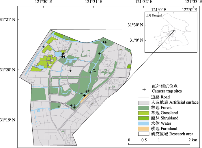
图1
上海杨浦区新江湾区域红外相机布设位点示意图
Fig. 1
Location of camera trap sites in the Xinjiangwan area, Yangpu District, Shanghai
2 研究方法
2.1 红外相机监测
2020年6月至2021年10月, 根据植被密度、人类活动情况、水源、动物痕迹及林下实际情况, 结合现场调查走访, 共在新江湾区域25个位点布设红外相机, 取样区域涵盖了混交林、河岸、草地等代表性区域。实际布设中, 相机装置用不易被盗取的自锁钢丝绳捆绑, 固定在树干上距离地面20-60 cm处, 前方正对预期野生动物会出现的位置, 距离2-5 m (李勤等, 2014)。在开阔空间中, 红外相机对于类似小灵猫体型的目标物种探测距离约15-20 m, 参数设置为触发连拍3张照片后拍摄一段20 s视频, 时间间隔为零, 灵敏度为中, 24 h连续监测, 监测期间每3个月更换一次电池并收集数据(李晟等, 2014)。
2.2 红外相机数据处理
按照红外相机位点建立对应文件夹, 整理相机记录的原始数据, 利用Bio-Photo V21软件导出表格, 删除空白照片, 对其余照片逐一进行物种识别, 记录物种类别、数量和独立探测事件(同一位点拍摄时间间隔超过30 min的物种探测) (肖治术等, 2014)。
2.3 遥感数据获取
从Google Earth获取覆盖研究区的分辨率为5 m的历史遥感影像(2000年), 在ArcGIS 10.7 (1995- 2019 Esri,
2.4 数据处理
2.4.1 小灵猫个体识别
对于每一次独立探测事件, 选择最清晰的1张或数张照片, 提取3个关键指标, 再将拍摄角度相近的照片一一进行比对(清晰度不足无法提取指标的照片归类为无法比较)。首先由团队中的两人分别给出“相同”或“不同”的判断, 再由第三人重新回看, 经由分析讨论, 个体识别结果达成一致(杨子诚等, 2018)。
2.4.2 小灵猫的时间活动特征
将小灵猫、流浪猫以及人类活动的探测时间转换为格林威治时间(GMT), 即平均太阳时间以消除时间差, 然后根据观测点的经纬度将太阳时间转换为真太阳时(Nouvellet et al, 2012)。使用核密度估计法(kernel density estimation, KDE), 根据探测记录, 在R 4.5.1中使用overlap包(Meredith & Ridout, 2021)生成物种日活动曲线, 评估物种的昼夜活动节律, 识别活动高峰, 并分别计算小灵猫与流浪猫、人类活动的时间重叠度指数(overlapping coefficient, ∆) (Ridout & Linkie, 2009)。
在此基础上, 利用回避-吸引指数(avoidance- attraction ratios, AAR)指标评价两物种在时间上是否存在回避、吸引等关系(Parsons et al, 2016)。本研究使用红外相机探测到的小灵猫和同一位点的流浪猫数据, 生成流浪猫和小灵猫的出现时间序列, 计算AAR:
图2
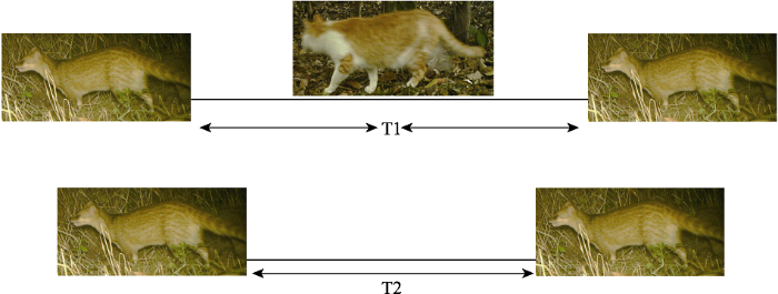
图2
小灵猫和流浪猫之间的时间响应模型图
Fig. 2
Avoidance-attraction ratio model between small Indian civet and stray cat
2.4.3 小灵猫的空间分布特征
计算每个位点人类、流浪猫、鸟类的相对多度指数(relative abundance index, RAI):
其中, T表示研究对象在该位点相机总工作日内的独立探测数, N表示相机工作日总天数(Bengsen et al, 2011)。
将相机位点分为探测到小灵猫和未探测到小灵猫两组, 首先采用Kolmogorov-Smirnov Z-test检验两组间的人类RAI、流浪猫RAI、鸟类RAI数据的正态性, 不符合正态分布的数据先进行转换使其符合正态分布, 再采用独立样本t检验来检验两组间的人类RAI、流浪猫RAI、鸟类RAI是否有显著性差异, 以此初步分析小灵猫的出现位点特征。
2.4.4 小灵猫的栖息地景观格局变化
通过ArcGIS 10.7重分类功能将土地利用类型分为绿地(林地、灌丛、草地)、水体(水体、海域)、人造地表和耕地4大类, 分别将研究区域2000年和2020年的土地利用栅格数据导入Fragstats 4.2.1 (www.umass.edu/landeco/research/fragstats), 计算斑块面积(CA)、斑块个数(NA)、斑块面积比(PLAND)、平均斑块大小(AREA_MN)、景观类型连接度(CONNECT) 5个景观指数, 评价研究区域景观类型从2000年到2020年的变化。
3 结果
3.1 红外相机调查结果
2020年6月至2021年10月, 累计在新江湾区域调查了25个位点, 红外相机总有效工作日1,581 d。其中共在9个位点拍摄到小灵猫照片213张、视频70段, 独立探测事件为65次。探测到小灵猫的9个位点分布在江湾生态走廊的中部和南部区域以及复旦大学江湾校区, 在临近的新江湾城公园、图书馆、滑板公园、小区周边绿地等区域未探测到小灵猫活动(图1)。
除小灵猫外, 这些位点大量记录到流浪猫、人类以及鸟类活动。共在23个位点拍摄到流浪猫照片2,910张、视频937段, 独立探测事件为692次; 在23个位点拍摄到鸟类照片9,789张、视频3,219段, 独立探测事件为2,087次; 在24个位点拍摄到人类活动照片6,784张、视频2,255段, 独立探测事件为749次。在探测到小灵猫的9个位点中, 有8个均拍摄到流浪猫、人类和鸟类(附录1)。
3.2 个体识别结果
图3
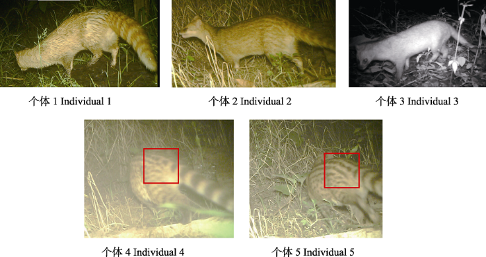
图3
小灵猫个体识别图(红框展示的是尾基部的间断和连续斑纹排列)
Fig. 3
Individual identification of small Indian civets (red box indicates discrete and continuous stripes)
表1 小灵猫个体特征表
Table 1
| 编号 No. | 体侧斑纹 Side spots | 尾部环纹 Tail stripe | 尾基部的斑纹排列形状 Spots on buttock |
|---|---|---|---|
| 1 | 无 None | 明显 Clear | 无斑纹 No spot |
| 2 | 浅淡 Light | 明显 Clear | 未知 Unknown |
| 3 | 无 None | 无 None | 不明显 Unclear |
| 4 | 明显 Clear | 明显 Clear | 斑纹间断 Discrete stripe |
| 5 | 明显 Clear | 明显 Clear | 斑纹连续 Continuous stripe |
3.3 小灵猫的活动节律
图4
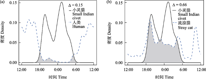
图4
小灵猫与人类(a)、流浪猫(b)日活动节律的关系
Fig. 4
Diel activity pattern of small Indian civet, human (a) and stray cat (b)
小灵猫-野猫-小灵猫的回避-吸引指数为9.94 ± 7.84, 显著大于1 (P < 0.05), 显示当流浪猫出现后, 小灵猫再次出现在相同区域的间隔时间显著增加。
3.4 小灵猫的空间分布
探测到小灵猫的9个位点的人类RAI为24.91 ± 17.95, 显著低于未探测到小灵猫的16个位点(RAI = 84.59 ± 95.81) (t = -2.539, P = 0.021)。
探测到小灵猫的位点的流浪猫RAI为44.17 ± 32.54, 未探测到小灵猫的位点的流浪猫RAI为44.29 ± 35.58, 二者无显著差异(t = -0.007, P = 0.995)。
探测到小灵猫的位点的鸟类RAI为206.82 ± 253.03, 显著高于未探测到小灵猫的位点(RAI = 149.52 ± 146.30) (t = 2.214, P = 0.037) (图5)。
图5
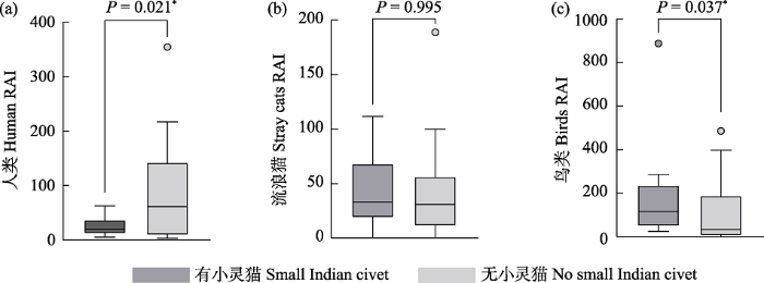
图5
小灵猫分布与人类活动(a)、流浪猫(b)、鸟类(c)相对多度指数(RAI)之间的关系。* P < 0.05。
Fig. 5
Relationship between the distribution of small Indian civet and human (a), stray cat (b), and bird (c) relative abundance index (RAI). * P < 0.05.
3.5 栖息地评价
近20年间新江湾区域的景观类型变化总体表现为绿地和耕地面积减少, 进而转换为人造地表。具体而言, 绿地(森林、草地和灌木)面积由390.84 ha缩小至215.21 ha, 面积占比由41.03%减少至22.59%。除整体绿地面积减小外, 残存绿地斑块数量由6个增加至42个, 导致平均斑块面积显著减小, 连接性指数由91.5降为23.45, 表明破碎化程度增加, 仅在江湾生态走廊沿岸地区尚存大面积连续的绿地(表2)。
表2 2000年与2020年上海市杨浦区新江湾区域景观指数
Table 2
| 绿地 Green space | 人造地表 Artificial surface | 水体 Water | 耕地 Farmland | 裸地 Barren | ||||||
|---|---|---|---|---|---|---|---|---|---|---|
| 2000 | 2020 | 2000 | 2020 | 2000 | 2020 | 2000 | 2020 | 2000 | 2020 | |
| 斑块面积 Patch area (ha) | 390.84 | 215.21 | 453.60 | 715.77 | 10.53 | 20.25 | 8.82 | 1.42 | 89.55 | 0 |
| 斑块面积占比 Percentage of patch area (%) | 41.03 | 22.59 | 47.55 | 75.13 | 1.10 | 2.13 | 0.92 | 0.15 | 9.39 | 0 |
| 斑块个数 Number of patch | 6 | 42 | 2 | 11 | 6 | 9 | 2 | 1 | 3 | 0 |
| 斑块平均面积 Mean patch area (ha) | 65.14 | 5.16 | 226.8 | 65.07 | 1.76 | 2.25 | 4.41 | 1.42 | 29.85 | 0 |
| 连接度指数 Connect index | 91.5 | 23.45 | 86.1 | 54.5455 | 33.33 | 36.11 | 0 | 0 | 83.3 | 0 |
绿地包含林地、草地、灌丛; 斑块面积占比表示各种类型地类占总面积的比例; 连接度指数是反映景观中斑块之间连接程度的指标。
Green space includes forest, grassland, and shrubland; The percentage of patch area represents the proportion of different land types to the total area; Connect index reflects the degree of connectivity between patches in the landscape.
4 讨论
本文首次对城市环境下的野生小灵猫种群开展调查, 初步探明在上海市新江湾区域存在一个至少包含5只小灵猫个体的极小种群, 其活动节律呈现严格夜行性, 并对人类活动和流浪猫呈现出显著的回避。在栖息地利用上, 小灵猫更多分布在人类干扰低的林下生境, 探测到小灵猫的位点鸟类相对多度较高且靠近水源。研究结果初步填补了野生小灵猫在城市环境的分布、活动节律和种间关系等方面信息, 随着后续更多工作的开展, 将为小灵猫未来的保护和管理提供科学支持。
以往研究表明, 中型捕食者在栖息地和资源利用上与顶级捕食者和竞争者产生空间和时间的分化, 是其降低生存风险的一种有效策略(Valeix et al, 2009)。本研究发现小灵猫的活动节律呈现严格夜行性, 与人类活动时间重叠指数较低, 探测到小灵猫的位点也大多是距离步道较远区域自然演替形成的次生林和灌丛生境, 表明小灵猫对人类活动的干扰存在显著回避。本研究中, 被纵横交错的步道所分隔的部分城市绿地斑块尽管面积较大, 但因为居民活动频繁, 小灵猫反而会回避在该区域活动(Watchorn et al, 2022)。同时, 小灵猫和流浪猫的活动习性以及食物需求可能存在部分重叠(图4b, 图5c), 导致二者之间可能存在空间和资源上的竞争关系。小灵猫和流浪猫的回避-吸引指数结果显示, 当流浪猫出现后小灵猫再次出现在相同区域的间隔时间会显著增加, 这说明小灵猫对流浪猫的活动存在时间上的回避, 活动节律曲线也显示小灵猫的活动高峰与流浪猫的活动高峰并不重叠, 这种在时间上的分化可能是减弱二者间竞争的方式之一。
近年来由于城市化进程对野生动物栖息地的挤压, 大中型野生动物进入到城市与人共存的情形越来越常见(郝辉等, 2009; Zari, 2018; Conejero et al, 2019)。本研究中稳定探测到小灵猫的位点均分布在新江湾区域靠近水域的林灌丛生境中。一方面林灌丛生境为小灵猫的活动提供了绝佳的隐蔽场所, 另一方面该生境中大量分布的鸟类、青蛙以及蜥蜴等小型脊椎动物能为小灵猫提供丰富的食物来源(Mudappa et al, 2007)。因为目前阶段的数据限制, 本文使用鸟类RAI作为栖息地食物组成的简单指标, 未对研究区域中小灵猫的潜在食物(两栖动物、昆虫等)进行调查, 这一数据缺失将在后续调查中加以补充。城市绿地中鸟类的多度往往与林下郁闭度、水源距离、昆虫和两栖动物丰富程度相关(Filloy et al, 2019; Villaseñor & Escobar, 2019), 因此是否探测到小灵猫的两组位点间鸟类RAI的显著差异, 仍能在一定程度上反映出小灵猫的栖息地利用特征。结合景观分析结果, 新江湾区域北部与黄浦江相邻, 但周边区域已随着城市开发逐渐转变为小灵猫难以生存的硬化地表和人造景观, 高楼林立的周边环境不利于小灵猫的迁移扩散。因此, 新江湾区域作为小灵猫在上海城市环境现存唯一的已知栖息地斑块, 具有重要的研究和保护价值(Aronson et al, 2017)。为保护城市环境之中的国家一级重点保护野生动物小灵猫, 在后续的新江湾区域的规划与改造过程中, 应当结合小灵猫本身的生物学习性, 尽量保留未经过多人为干预的林灌丛生境, 加强对城市流浪猫的管控与治理, 采用乡土物种营造近自然的植被环境, 为小灵猫及其他重点保护物种在城市生境中的长期维持创造条件(Li et al, 2020)。
本研究作为拟围绕小灵猫进行长期研究的前期工作, 周期较短、数据量有限, 旨在快速调查小灵猫在新江湾区域的分布情况, 填补相关空白, 也为今后的保护与研究工作提供数据基础。后续工作将扩大研究范围, 获取更长时间的监测数据, 系统地研究小灵猫对城市环境的响应机制, 评估上海市小灵猫的适宜栖息地和潜在栖息地, 并结合占域模型(occupancy model) (MacKenzie et al, 2004)、空间标记-重捕模型(spatially explicit capture-recapture, SECR) (Borchers & Efford, 2008)和DNA分子标记等技术对上海市小灵猫的栖息地选择、种群密度和遗传结构进行研究, 以期为城市生物多样性保护长期政策的制定提供科学支持。
附录 Supplementary Material
附录1 上海市杨浦区新江湾区域各红外相机位点小灵猫、流浪猫、鸟类和人类独立探测事件数
Appendix 1 Number of independent detection events of small Indian civets, stray cats, birds and human at each camera trap sites in the Xinjiangwan area, Yangpu District, Shanghai
致谢
本研究得到上海市林业总站及上海市杨浦区绿化和市容管理局的支持与指导, 野外红外相机的布设得到了复旦大学肖乐遥、李骥玄、臧少平、夏希昱、丁雨顺等同学的协助, 在此表示最诚挚的谢意!
参考文献
Biodiversity in the city: Key challenges for urban green space management
First record of small Indian civet (Viverricula indica) from Azad Jammu and Kashmir Himalaya, Pakistan
Using a general index approach to analyze camera-trap abundance indices
Spatially explicit maximum likelihood methods for capture-recapture studies
Live-trapping capture-recapture studies of animal populations with fixed trap locations inevitably have a spatial component: animals close to traps are more likely to be caught than those far away. This is not addressed in conventional closed-population estimates of abundance and without the spatial component, rigorous estimates of density cannot be obtained. We propose new, flexible capture-recapture models that use the capture locations to estimate animal locations and spatially referenced capture probability. The models are likelihood-based and hence allow use of Akaike's information criterion or other likelihood-based methods of model selection. Density is an explicit parameter, and the evaluation of its dependence on spatial or temporal covariates is therefore straightforward. Additional (nonspatial) variation in capture probability may be modeled as in conventional capture-recapture. The method is tested by simulation, using a model in which capture probability depends only on location relative to traps. Point estimators are found to be unbiased and standard error estimators almost unbiased. The method is used to estimate the density of Red-eyed Vireos (Vireo olivaceus) from mist-netting data from the Patuxent Research Refuge, Maryland, U.S.A. Estimates agree well with those from an existing spatially explicit method based on inverse prediction. A variety of additional spatially explicit models are fitted; these include models with temporal stratification, behavioral response, and heterogeneous animal home ranges.
Activity patterns and habitat use of sympatric small carnivores in southern Taiwan
Past experiences drive citizen perception of wild boar in urban areas
DOI:10.1016/j.mambio.2019.04.002
[本文引用: 1]

Wild boar (Sus scrofa) populations in urban environments have increased during the last decades. This has led to a new scenario where humans share the space with this recent colonising species inside urban areas. Citizen perception on wild boar presence must be taken into account to assure the most suitable design, application and acceptance of management measures. In order to advance in the knowledge and comprehension of urban wild boar perception by citizens, we conducted 181 surveys to women and men representing all age classes. Our questions were focused on assessing citizen features, experiences and attitudes regarding wild boar presence in the urban area of La Floresta (Sant Cugat del Valles, Barcelona, Spain). We used a recursive partitioning approach through regression trees to explore the relationship between a Wild Boar Perception Score (WBPS) and citizen profile, past and current experiences involving wild boars, contact with wild boars and acceptance of management measures. Our results show that the WBPS is mainly driven by previous incidents suffered by the respondent, independently of citizen profile, current experiences, level of contact and acceptance of management measures. The respondents answered that measures should be taken to minimize wild boar incidents (37%) and to help wild boars to return to their habitat (27%), whereas 16% chose to coexist with wild boars in the current conditions. Culling all the wild boars was not supported at all, even among the citizens with the most negative perception of wild boar. Citizens with positive perception of wild boar presence in urban areas contribute to reinforce the phenomenon by feeding wild boars. Our results verify that socio-demographic variables such as gender, education and public health concern are less important than past experiences to drive citizen perception and explain resident attitudes. Information campaigns on the causes, consequences and effective management options for urban wildlife could help to improve understanding and acceptance of the circumstances and currently non-socially accepted possible solutions. Evaluation of citizen perception and information campaigns should precede wildlife management measures, in order to gain acceptance by residents before being implemented. (C) 2019 Published by Elsevier GmbH on behalf of Deutsche Gesellschaft fur Saugetierkunde.
Activity laws and feeding behavior of introduced badgers
引入狗獾活动规律和取食行为的研究
Estimating mammalian diversity and relative abundance using camera traps in a tropical deciduous forest of Kuldiha Wildlife Sanctuary, Eastern India
Estimating the impacts of habitat loss induced by urbanization on bird local extinctions
DOI:10.1016/j.biocon.2021.109064 URL [本文引用: 1]
Bird diversity in urban ecosystems: The role of the biome and land use along urbanization gradients
DOI:10.1007/s10021-018-0264-y [本文引用: 1]
The influence of human disturbance on wildlife nocturnality
DOI:10.1126/science.aar7121
PMID:29903973
[本文引用: 1]
Rapid expansion of human activity has driven well-documented shifts in the spatial distribution of wildlife, but the cumulative effect of human disturbance on the temporal dynamics of animals has not been quantified. We examined anthropogenic effects on mammal diel activity patterns, conducting a meta-analysis of 76 studies of 62 species from six continents. Our global study revealed a strong effect of humans on daily patterns of wildlife activity. Animals increased their nocturnality by an average factor of 1.36 in response to human disturbance. This finding was consistent across continents, habitats, taxa, and human activities. As the global human footprint expands, temporal avoidance of humans may facilitate human-wildlife coexistence. However, such responses can result in marked shifts away from natural patterns of activity, with consequences for fitness, population persistence, community interactions, and evolution.Copyright © 2018 The Authors, some rights reserved; exclusive licensee American Association for the Advancement of Science. No claim to original U.S. Government Works.
Activity patterns of badgers in suburbs of Shanghai
上海郊区狗獾活动规律的初步研究
The importance of land governance for biodiversity conservation in an era of global urban expansion
DOI:10.1016/j.landurbplan.2018.01.011 URL [本文引用: 1]
A multi-sensor and multi-temporal remote sensing approach to detect land cover change dynamics in heterogeneous urban landscapes
DOI:10.1016/j.ecolind.2018.12.033
[本文引用: 1]
With global changes such as climate change and urbanization, land cover is prone to changing rapidly in cities around the globe. Urban management and planning is challenged with development pressure to house increasing numbers of people. Most up-to date continuous land use and land cover change data are needed to make informed decisions on where to develop new residential areas while ensuring sufficient open and green spaces for a sustainable urban development. Optical remote sensing data provide important information to detect changes in heterogeneous urban landscapes over long time periods in contrast to conventional approaches such as cadastral and construction data. However, data from individual sensors may fail to provide useful images in the required temporal density, which is particularly the case in mid-latitudes due to relatively abundant cloud coverage. Furthermore, the data of a single sensor may be unavailable for an extended period of time or to the public at no cost. In this paper, we present an integrated, standardized approach that aims at combining remote sensing data in a high resolution that are provided by different sensors, are publicly available for a long-term period of more than ten years (2005-2017) and provide a high temporal resolution if combined. This multi-sensor and multi-temporal approach detects urban land cover changes within the highly dynamic city of Leipzig, Germany as a case. Landsat, Sentinel and RapidEye data are combined in a robust and normalized procedure to offset the variation and disturbances of different sensor characteristics. To apply the approach for detecting land cover changes, the Normalized Difference Vegetation Index (NDVI) is calculated and transferred into a classified NDVI (Classified Vegetation Cover-CVC). Small scale vegetation development in heterogeneous complex areas of a European compact city are highlighted. Results of this procedure show successfully that the presented approach is applicable with divers sensors' combinations for a longer time period and thus, provides an option for urban planning to update their land use and land cover information timely and on a small scale when using publicly available no cost data.
Dependence of the leopard Panthera pardus fusca in Jaipur, India, on domestic animals
DOI:10.1017/S0030605319001145
URL
[本文引用: 1]
The ecology and predator–prey dynamics of large felids in the tropics have largely been studied in natural systems where wild ungulates constitute the majority of the prey base. However, in tropical countries where communities are primarily agrarian, the high density of domestic animals in human-dominated landscapes can be a potential prey source for large carnivores. We demonstrate almost complete dependence of the Vulnerable leopard Panthera pardus fusca in the Jhalana Reserve Forest in Jaipur, north-west India on domestic animals as prey. We analysed 132 leopard scats collected during the dry season of November 2017–April 2018. Domestic animals comprised the majority of the leopards' prey (89.5% frequency of occurrence): dogs Canis lupus familiaris (44%), cats Felis catus (13%), goats Capra aegagrus hircus (16%) and cattle Bos taurus (15%). Wild species, which occurred in the leopards' diet at a relatively low frequency, were rodents, the hare Lepus nigricollis, small Indian civet Viverricula indica, rhesus macaque Macaca mulatta, northern plains grey langur Semnopithecus entellus and mongoose Herpestes edwardsii. Diet is also a function of availability of potential prey, but no data are available on the density of the leopard's wild prey species in Jhalana Reserve Forest. Nevertheless, our results suggest that abundance of domestic prey around Jhalana Reserve Forest sustains the c. 25 known leopards. We conclude that these leopards, by preying on feral dogs in an urban environment, could be considered as suppliers of a service to the human population amongst whom they thrive, although this potentially exposes the leopards to the canine distemper virus.
Understanding how free-ranging cats interact with humans: A case study in China with management implications
DOI:10.1016/j.biocon.2020.108690 URL [本文引用: 1]
Applications of camera trap in wildlife population ecology
相机陷阱在野生动物种群生态学中的应用
Camera-trapping in wildlife research and conservation in China: Review and outlook
DOI:10.3724/SP.J.1003.2014.14203
[本文引用: 1]
During the last two decades, infrared-triggered camera-trapping has been widely used in wildlife and biodiversity research and conservation. In the areas of wildlife ecology research, animal species inventory, biodiversity monitoring and protected area management in China, considerable outputs have been produced by scientific research and conservation applications based on camera-trapping. This technique has been successfully used to detect rare or elusive species, conduct biodiversity inventory, study animal behavior, estimate population parameters, and evaluate the effectiveness of protected area management. Along with the rapid development of modern ecological analysis and modeling tools, camera-trapping will play a more important role in wildlife research at various levels. Meanwhile, along with improvements in techniques, decreasing cost and increasing application interests, camera-trapping will be adopted by more researchers, wildlife managers and protected areas, and can be used for systematic wildlife monitoring using standard protocols. Efforts devoted to its future development and applications should focus on establishing systematically-designed monitoring networks and data-sharing protocols, and developing new analytical approaches and statistical models specifically based on camera-trapping data.
红外相机技术在我国野生动物研究与保护中的应用与前景
DOI:10.3724/SP.J.1003.2014.14203
[本文引用: 1]
20年来, 红外相机技术在国内外野生动物研究、监测与保护中得到了广泛应用。基于红外相机技术, 我国在野生动物生态学研究、动物行为学研究、稀有物种的探测与记录、动物本底资源调查、生物多样性监测及保护地管理与保护评价等领域取得了众多成果。目前, 数学模型、统计分析方法和新的概念正在促进红外相机技术在野生动物监测研究与保护管理中的发展和推广应用。同时, 随着红外相机技术的成熟、成本降低和应用普及, 这一技术也将会被更多的野生动物研究人员、管理人员和自然保护区管理者所采用, 并成为全国各级保护地和区域生物多样性监测研究的关键技术和方法。今后, 建立并完善系统化的监测网络和数据共享平台、开发新一代的数据分析方法与模型, 将是此项技术进一步发展和应用的主要方向。
On the assessment of big cats and their prey populations based on camera trap data
DOI:10.3724/SP.J.1003.2014.14079
[本文引用: 1]
The development of camera traps has improved our ability to study Amur tigers (Panthera tigris altaica), Amur leopards (Panthera pardus orientalis) and their prey populations. This research introduces camera trap monitoring methods of Amur tigers, Amur leopards and their prey populations in Chunhua and Madida areas of the Hunchun Nature Reserve, Changbai Mountains, China. A selection of monitoring positions, methods of erecting, parameter settings, and data filtering techniques are presented. Additionally, unique identifiers of Amur tigers and Amur leopards based on body patterns, calculations of relative abundance indexes (RAI), and the establishment of RAI models between the predators and prey are presented. We discuss the applicability of unique identifiers with ipsilateral patterns, the differences between camera trap monitoring and traditional survey methods, and the error of camera trap monitoring. We conclude that predicting densities of Amur tigers and Amur leopards with camera traps and automatic-individual-identifiers still needs improvement. Camera trap densities of one pair per 25 km2 can meet the needs for Amur tigers and leopards within Chunhua and Madida of the Hunchun Nature Reserve, but a separate monitoring project is needed for ungulates prey.
探讨基于红外相机技术对大型猫科动物及其猎物的种群评估方法
DOI:10.3724/SP.J.1003.2014.14079
[本文引用: 1]
红外相机技术的发展促进了对东北虎(Panthera tigris altaica)、东北豹(Panthera pardus orientalis)及其猎物种群的研究。本研究以珲春保护区春化和马滴达两个区域的监测结果为例, 介绍利用该技术对我国长白山区东北虎、东北豹及其猎物的种群评估方法, 包括监测位点的选择、相机的架设方式及参数设置、数据筛选、东北虎和东北豹体侧花纹个体识别方法、物种相对丰富度的计算以及捕食者与猎物丰富度关系模型的构建。最后就东北虎、东北豹体侧花纹个体识别技术的适用性、红外相机监测与传统调查方法的差异, 相机监测的误差进行了讨论。研究表明, 利用红外相机技术进行密度预测以及东北虎、东北豹个体自动识别技术还需继续完善。1对/25 km<sup>2</sup>的相机架设密度基本上满足对于珲春保护区春化至马滴达区域虎豹的监测强度要求, 但对于有蹄类则需要另外的监测方案。
Investigating species co-occurrence patterns when species are detected imperfectly
DOI:10.1111/jae.2004.73.issue-3 URL [本文引用: 1]
Responses of small carnivores to rainforest fragmentation in the southern Western Ghats, India
Assessing land use-land cover change and its impact on land surface temperature using LANDSAT data: A comparison of two urban areas in India
DOI:10.1007/s41748-020-00155-9 [本文引用: 1]
Noisy clocks and silent sunrises: Measurement methods of daily activity pattern
DOI:10.1111/jzo.2012.286.issue-3 URL [本文引用: 1]
Spatiotemporal patterns of lion space use in a human-dominated landscape
The ecological impact of humans and dogs on wildlife in protected areas in eastern North America
DOI:10.1016/j.biocon.2016.09.001 URL [本文引用: 2]
Urbanization drives cross-taxon declines in abundance and diversity at multiple spatial scales
DOI:10.1111/gcb.14934
PMID:31755626
[本文引用: 1]
The increasing urbanization process is hypothesized to drastically alter (semi-)natural environments with a concomitant major decline in species abundance and diversity. Yet, studies on this effect of urbanization, and the spatial scale at which it acts, are at present inconclusive due to the large heterogeneity in taxonomic groups and spatial scales at which this relationship has been investigated among studies. Comprehensive studies analysing this relationship across multiple animal groups and at multiple spatial scales are rare, hampering the assessment of how biodiversity generally responds to urbanization. We studied aquatic (cladocerans), limno-terrestrial (bdelloid rotifers) and terrestrial (butterflies, ground beetles, ground- and web spiders, macro-moths, orthopterans and snails) invertebrate groups using a hierarchical spatial design, wherein three local-scale (200 m × 200 m) urbanization levels were repeatedly sampled across three landscape-scale (3 km × 3 km) urbanization levels. We tested for local and landscape urbanization effects on abundance and species richness of each group, whereby total richness was partitioned into the average richness of local communities and the richness due to variation among local communities. Abundances of the terrestrial active dispersers declined in response to local urbanization, with reductions up to 85% for butterflies, while passive dispersers did not show any clear trend. Species richness also declined with increasing levels of urbanization, but responses were highly heterogeneous among the different groups with respect to the richness component and the spatial scale at which urbanization impacts richness. Depending on the group, species richness declined due to biotic homogenization and/or local species loss. This resulted in an overall decrease in total richness across groups in urban areas. These results provide strong support to the general negative impact of urbanization on abundance and species richness within habitat patches and highlight the importance of considering multiple spatial scales and taxa to assess the impacts of urbanization on biodiversity.© 2019 John Wiley & Sons Ltd.
Estimating overlap of daily activity patterns from camera trap data
DOI:10.1198/jabes.2009.08038 URL [本文引用: 1]
Individual automatic detection and identification of big cats with the combination of different body parts
DOI:10.1111/inz2.v18.1 URL [本文引用: 1]
Amur tiger individual automatic identification based on object detection
基于目标检测的东北虎个体自动识别
What do predator diets tell us about mammal declines in Kakadu National Park?
DOI:10.1071/WR17101
URL
[本文引用: 1]
\n\n\nContext\nSmall- and medium-sized native mammals have suffered severe declines in much of northern Australia, including within protected areas such as Kakadu National Park. Several factors have been implicated in these declines but predation, particularly by feral cats (Felis catus), has been identified as potentially the most direct cause of decline for many species.\n\nAims\nWe evaluated how prey frequency changed in cat and dingo scats in Kakadu from the early 1980s to 2013–15, with this period spanning a severe decline in the small- and medium-sized mammal fauna.\n\nMethods\nChi-square test of independence and Fisher’s exact test were used to compare prey frequencies between dingoes and cats, and among years to assess significance of temporal change.\n\nKey results\nSmall-sized native mammals were the prey item occurring at the highest frequency in scats for both dingoes and cats in the 1980s. Prey content in dingo and cat scats differed in the 2010s with macropods predominating in the scats of dingoes, and medium-sized native mammals predominating in cat scats. The frequency of occurrence of small-sized native mammals declined in both dingo and cat scats between the 1980s and 2010 sampling periods, while the frequency of occurrence of medium-sized native mammals remained constant in dingo scats and increased in cat scats.\n\nConclusions\nSmall mammals were a major component of the diets of both dingoes and cats in Kakadu in the 1980s, when small mammals were much more abundant. Despite marked reduction from the 1980s to the 2010s in the capture rates of both small- and medium-sized native mammals, some species continue to persist in the diets of cats and dingoes at disproportionally high frequencies. Both predators continue to exert predatory pressure on mammal populations that have already experienced substantial declines.\n\nImplications\nAlthough predation by feral cats is a major threat to small- and medium-sized native mammals, dingoes may also play an important role in limiting their recovery. Disturbance from fire and grazing by introduced herbivores has been shown to augment predatory impacts of feral cats on native mammals. Predation more generally, not just by feral cats, may be exacerbated by these disturbance processes. Management programs that solely focus on mitigating the impact of feral cats to benefit threatened species may be inadequate in landscapes with other significant disturbance regimes and populations of predators.\n\n
Does the risk of encountering lions influence African herbivore behaviour at waterholes?
DOI:10.1007/s00265-009-0760-3 URL [本文引用: 1]
Cemeteries and biodiversity conservation in cities: How do landscape and patch-level attributes influence bird diversity in urban park cemeteries?
DOI:10.1007/s11252-019-00877-3 [本文引用: 1]
Habitat fragmentation reduces genetic diversity and connectivity of the Mexican spotted owl: A simulation study using empirical resistance models
DOI:10.3390/genes9080403
URL
[本文引用: 1]
We evaluated how differences between two empirical resistance models for the same geographic area affected predictions of gene flow processes and genetic diversity for the Mexican spotted owl (Strix occidentalis lucida). The two resistance models represented the landscape under low- and high-fragmentation parameters. Under low fragmentation, the landscape had larger but highly concentrated habitat patches, whereas under high fragmentation, the landscape had smaller habitat patches that scattered across a broader area. Overall habitat amount differed little between resistance models. We tested eight scenarios reflecting a factorial design of three factors: resistance model (low vs. high fragmentation), isolation hypothesis (isolation-by-distance, IBD, vs. isolation-by-resistance, IBR), and dispersal limit of species (200 km vs. 300 km). Higher dispersal limit generally had a positive but small influence on genetic diversity. Genetic distance increased with both geographic distance and landscape resistance, but landscape resistance displayed a stronger influence. Connectivity was positively related to genetic diversity under IBR but was less important under IBD. Fragmentation had a strong negative influence on the spatial patterns of genetic diversity and effective population size (Ns). Despite habitats being more concentrated and less widely distributed, the low-fragmentation landscape had greater genetic diversity than the high-fragmentation landscape, suggesting that highly concentrated but larger habitat patches may provide a genetic refuge for the Mexican spotted owl.
Artificial habitat structures for animal conservation: Design and implementation, risks and opportunities
DOI:10.1002/fee.v20.5 URL [本文引用: 1]
Setts habitat features of reintroduced Meles meles after Release
重引入狗獾释放后定居巢的生境特征
Developing camera-trapping protocols for wildlife monitoring in Chinese forests
DOI:10.3724/SP.J.1003.2014.14075
[本文引用: 1]
Wildlife monitoring is one key indicator used for biodiversity assessment. Therefore, developing wildlife monitoring protocols is an important component of large-scale biodiversity monitoring program such as the Chinese Forest Biodiversity Monitoring Network (CForBio). Since 2011, the CForBio Network launched an initiative to investigate wildlife diversity using camera traps among forest dynamic plots in China. Because of this initiative, there is an urgent need to develop standardized camera trapping protocols. One important premise of camera-trapping protocols is that camera trap data can be used to conduct comparative research among different plots. Here, we propose camera-trapping protocols based on our own experience in using camera traps for wildlife surveys, and on the terrestrial vertebrate (camera trap) protocol implementation manual produced by the TEAM (Tropical Ecology Assessment & Monitoring) Network. We hope that these protocols can serve as the basis for a standardized tool used in wildlife diversity monitoring in forest ecosystems. We also provide recommendations for plot design, data management and long-term monitoring programs for wildlife diversity monitoring.
探讨我国森林野生动物红外相机监测规范
DOI:10.3724/SP.J.1003.2014.14075
[本文引用: 1]
野生动物多样性是生物多样性监测与保护管理评价的关键指标, 因此对野生动物进行长期监测是中国森林生物多样性监测网络(CForBio)等大尺度生物多样性监测研究计划的一个重要组成部分。2011年以来, CForBio网络陆续在多个森林动态监测样地开展以红外相机来监测野生动物多样性。随着我国野生动物红外相机监测网络的初步形成, 亟待建立和执行基于红外相机技术的统一监测规范。基于3年来在我国森林动态监测样地红外相机监测的进展情况, 以及热带生态评价与监测网络针对陆生脊椎动物(兽类和鸟类)所提出的红外相机监测规范, 本文从监测规范和监测注意事项等方面探讨了我国森林野生动物红外相机监测的现状和未来。
Individual identification and population size assessment for Asian elephant based on camera-trapping techniques
DOI:10.16829/j.slxb.150109
[本文引用: 1]
We studied and assessed the minimum population number of Asian elephants (<em>Elephas maximus</em>) in Shangyong Sub-Reserve (SYSR), Xishuangbanna National Nature Reserve in Yunnan Province, China using camera-traps. We set up 27 camera-traps in SYSR from January to April 2016, which ran for a total of 621 camera-trap days and obtained 1944 sample photographs. Within this period individual camera units were active for between 9-52 full days (mean=24). We identified a minimum number of 69 unique individual elephants from photographs (38 adults, 16 sub-adults, 15 calfs) in SYSR. We detected 7 Asian elephants that moved actively across the China-Laos border. The advantages and disadvantages of our camera-trap methodology compared with those of other techniques for individual identification is discussed, and we explore the potential for robust methods for fast, real-time and effective population evaluation in the future. This study strengthened our understanding of Asian elephant status in SYSR and provides scientific evidence to support conservation planning and actions.
基于红外相机技术对亚洲象个体识别和种群数量的评估
The importance of urban biodiversity—An ecosystem services approach
DOI:10.15406/bij URL [本文引用: 1]
Impact of urbanization-related land use land cover changes and urban morphology changes on the urban heat island phenomenon
DOI:10.1016/j.scitotenv.2018.04.091 URL [本文引用: 1]
