


传统上, 野生动物活动节律的研究主要依赖于行为学观察, 正在进行移动、觅食、警戒、玩耍等个体行为和个体间互动(即社会行为)的动物被认为处于“活跃”(active)状态, 而在静止休息中的动物被认为处于“不活跃”(inactive)状态。近二十年间, 红外相机技术凭借其对动物干扰小、数据量大、易于标准化推广等优点, 已被越来越多地应用到野生动物调查中(肖治术等, 2014; 李晟, 2020), 尤其是那些数量稀少、行踪隐秘、对人类干扰敏感的动物类群(李勤等, 2013; 李晟等, 2014)。红外相机技术提供了目标动物大量的时空、行为信息, 被广泛地应用于国内外众多野生动物活动节律的研究, 如雪豹(Panthera uncia)、亚洲金猫(Catopuma temminckii)等多种野生猫科动物(王渊等, 2019; 施小刚等, 2021)。在这些研究中, 通常认为动物被红外相机拍摄到的概率与其活动强度(即处于“活跃”状态的时间比例)呈正相关, 这一假设被作为红外相机活动节律分析的前提与基础(Azlan & Sharma, 2006; Li et al, 2010)。
近年来, 卫星定位技术的迅速发展为野生动物研究提供了更多可能性。卫星定位追踪颈圈能够近乎实时地提供较精确的位置信息(Lashley et al, 2018), 其优点在于可以自动采集并反馈信息, 无需人力监测(Matthews et al, 2013; Goldingay, 2015)。由于追踪颈圈可以提供动物的连续移动的时空信息, 因此能够利用连续定位点求得一段时间内的移动距离(Ordiz et al, 2017), 进而获得动物在此期间的移动速率, 表征动物的活动节律(Lashley et al, 2018; Edwards et al, 2021)。近十年来, 颈圈中增加配置了多轴加速度计, 可以记录动物活动的加速度信息, 进而计算一定时间段内动物的活动量, 为动物活动节律的估算提供了更直接的信息(Edwards et al, 2021)。但由于价格相对昂贵、需要对动物进行捕捉等方面的限制, 卫星追踪颈圈在野生猫科动物活动节律研究中的应用目前还相对较少。
荒漠猫(Felis bieti)是分布于青藏高原东部的小型猫科动物。目前, 对于荒漠猫的分类地位仍存有争议。Yu等(2021)基于全基因组测序数据对荒漠猫的分类地位进行了系统的遗传学分析, 认为荒漠猫应被划分为野猫的一个亚种, 拉丁名为Felis silvestris bieti; 而在IUCN受威胁物种红色名录(Riordan et al, 2015)、《中国兽类名录(2021版)》(魏辅文等, 2021; 余文华等, 2021)和中国国家重点保护野生动物名录(
红外相机和卫星追踪颈圈是目前研究野生猫科动物活动节律的两种主要手段。但由于这两种方法的数据获取机制不同, 在评估目标个体的活动强度时, 对于动物是否处于“活跃”(active)状态的判断存在差异, 因此可能带来不同的估算结果。然而, 目前缺乏对于两种方法的比较研究(Lashley et al, 2018; Edwards et al, 2021)。为了系统对比不同的数据收集方法获得的野生猫科动物活动节律模式之间的差异, 探究其背后可能的原因, 本研究选择祁连山国家公园青海片区为研究区域, 以青海省门源回族自治县的荒漠猫为例, 同时使用两种方法获取荒漠猫的活动数据: (1)红外相机记录(安装于洞口处、兽径处以及两者组合); (2)卫星追踪颈圈记录的活动量数据。首先探究红外相机或卫星追踪颈圈是否可以作为全面估算动物活动节律的准确方法, 其次结合动物行为学, 识别在“活跃”或“不活跃”的二元化分类中, 不同数据收集方法对目标动物各类细分行为的判断, 以探究不同方法所得出的活动模式背后的行为学与生态学意义。本研究的结果可以帮助我们更深入地了解野生猫科动物的行为模式与生态特征, 为相关方法在野生动物活动节律和行为研究中的应用和研究结果的解读提供参考。
1 研究区域
研究区域位于青海省门源回族自治县(37.34°- 37.52° N, 101.42°-101.76° E), 地处祁连山国家公园试点区青海片区东侧边缘, 北临祁连山, 南靠达坂山, 形成气候相对湿润、水量充足的盆地地形(贾慧萍等, 2021)。研究区域海拔2,900-3,100 m, 属于高原亚寒带气候, 1月均温-13.4℃, 7月均温11.9℃, 年均降水量520 mm (
2 方法
2.1 数据收集与处理
2.1.1 红外相机
2020年5月至2021年6月, 在研究区域内荒漠猫活动较为频繁、利用率较高的造林地内放置25台红外相机(型号为易安卫士L710) (图1)。红外相机布设在有荒漠猫活动痕迹(如荒漠猫粪便)的兽径(23台)和洞口(2台)。相机固定在木桩或树干上, 距离地面约40 cm。相机前尽量保证无遮挡, 并避免镜头朝南, 以减少空拍。同一周期布设的红外相机调查位点间距不小于500 m。记录每个相机安装位点的经纬度、海拔等信息, 每2-3个月进行一次相机检查维护与数据回收。
图1
图1
研究区域内红外相机布设点及荒漠猫捕捉位点
Fig. 1
The camera stations and capture locations of Chinese mountain cats within the study area
对获取的红外相机照片进行人工筛选和物种鉴定, 使用开源的图像管理程序digiKam (V7.3.0) (
2.1.2 卫星追踪颈圈
2021年3-10月, 经国家林业和草原局、青海省林业和草原局、祁连山国家公园管理局等管理部门的审批许可, 在研究区域内使用捕捉笼捕捉野生荒漠猫, 佩戴卫星定位追踪颈圈(环球信士HQAN40S, 颈圈重量150 g, 低于荒漠猫体重的3%)后随即原地放归(附录1)。共成功捕捉荒漠猫成年个体10只, 其中7只为雌性, 3只为雄性(表1)。
表1 本研究中佩戴卫星追踪颈圈的10只荒漠猫信息
Table 1
| 编号 ID | 性别 Gender | 有效追踪天数 Effective tracking days | 定位点数量 Number of fixed locations |
|---|---|---|---|
| PKU001 | 雌 Female | 279 | 9,922 |
| PKU002 | 雌 Female | 278 | 13,969 |
| PKU003 | 雌 Female | 274 | 14,865 |
| PKU004 | 雄 Male | 230 | 7,396 |
| PKU005 | 雄 Male | 44 | 4,548 |
| PKU006 | 雌 Female | 73 | 2,029 |
| PKU007 | 雌 Female | 70 | 3,639 |
| PKU008 | 雄 Male | 69 | 3,802 |
| PKU009 | 雌 Female | 69 | 2,229 |
| PKU010 | 雌 Female | 46 | 543 |
卫星追踪颈圈为“GPS + 北斗”双模定位, 设置为每20 min至3 h定位一次。如颈圈电压充足, 则保持每20 min一次的定位频率; 如颈圈出现低电压报警, 则定位频率自动调整为每3 h一次, 待颈圈通过太阳能充电、电压回升后再调整回原定位频率。颈圈数据通过GSM网络回传, 包括颈圈编号、日期、时间、经纬度坐标、海拔、定位精度等。颈圈内置有运动传感器(三轴加速度计), 可以自动计算两次定位时间段内荒漠猫的活动步数, 作为“活动量”包含在回传数据中。
2.2 数据分析
2.2.1 红外相机数据
使用核密度估算(kernel-density estimation)的方法(Ridout & Linkie, 2009), 根据红外相机调查所得荒漠猫每次独立探测的拍摄时间(UTC/GMT+ 08:00), 绘制荒漠猫的活动强度曲线, 估算荒漠猫的日活动节律。该方法假设: (1)目标动物在特定时间内的活动强度与其被红外相机拍摄到的概率成正比; (2)红外相机的每次探测(独立有效拍摄)均为独立事件, 是对目标动物在一天24 h中特定时间段内被红外相机拍摄到的概率分布的随机采样; (3)上述分布的概率密度函数即可认为是该物种的活动节律(Ridout & Linkie, 2009; 朱博伟等, 2019), 其公式为:
按照红外相机不同的安装位置, 将数据分为洞口处、兽径处、全部(也即两者组合) 3组, 基于核密度估算的方法分别建立上述3组数据的荒漠猫日活动节律模型。上述活动节律分析使用R 3.4的“overlap”程序包完成(Meredith & Ridout, 2021)。
2.2.2 卫星追踪颈圈数据
2.2.3 不同调查方法所得日活动节律对比
使用重叠系数对上述调查方法所得的日活动节律进行对比。重叠系数是一个0-1之间的连续变量, 为两条密度曲线重叠区域的面积, 当重叠系数为1时, 表明两条曲线完全一致(Ridout & Linkie, 2009)。重叠系数预测值与样本量大小有关, 由最小一组样本量决定: 当最小样本数量小于50时, Δ1预测值表现最好; 而当样本数量大于75时, Δ4预测值表现最好(Ridout & Linkie, 2009)。根据较小的样本量, 选择合适的重叠系数, 判断重叠度。采用平滑自主抽样计算重叠系数的95%置信区间。重叠系数和置信区间的计算使用R 3.4软件的“overlap”程序包完成(Meredith & Ridout, 2021)。使用沃尔德检验(Wald test)判断不同方法所得日活动节律之间的差异是否显著, 该检验使用R 3.4软件的“activity”程序包完成(Rowcliffe, 2016)。
为了进一步探究不同方法所获得的动物活动记录所对应的行为类别和背后的行为学意义, 参考动物行为学研究中猫科动物的行为分类与定义(Stanton et al, 2015), 结合本研究期间人为观察记录, 编制了荒漠猫的简化行为谱。根据行为谱中的各类行为, 分别统计传统行为学观察、安装在洞口处红外相机的探测、安装在兽径处红外相机的探测、卫星追踪颈圈记录这4种方法所记录到的荒漠猫的各类行为, 并判别: (1)该行为是否可以被该方法有效探测记录到, 分为可以被有效记录到(√)、少部分被记录到(R)和无法被记录到(×); (2)该行为发生时, 目标动物会被该方法判断为处于“活跃(记录为A)”还是“不活跃(记录为I)”状态。其中, 在本研究的卫星追踪颈圈方法中, 某类行为“被记录到”指该行为可以在颈圈内置的三轴加速度计中有效产生计步数据。然后, 以对基于不同来源数据所获得的日活动节律模式之间的差异进行对比讨论。
3 结果
2020年5月至2021年6月, 25台红外相机共工作5,810个有效相机日(camera-days), 获取照片或视频记录272,484条。其中, 荒漠猫记录2,988条, 独立探测596次(设置在洞口与兽径的相机获得的荒漠猫独立探测数分别为173次与423次)。本研究调查的两个洞口, 其中一个记录到由1只雌性成体及2只亚成体组成的母幼群, 另一个只记录到成体荒漠猫。10只佩戴颈圈的荒漠猫的累积有效追踪天数共1,432天, 回传数据共62,942条。基于回传数据中的活动量数据生成随机时间点28,465,800个, 进一步随机抽样10%后获得时间点2,846,580个。
安装于不同位置的红外相机与卫星追踪颈圈数据所获得的日活动节律曲线如图2所示。根据全部红外相机探测数据估算荒漠猫日活动节律: 荒漠猫在全天均保持活跃, 在黄昏17:00-19:00时段有一个活动高峰, 其他时段也具有一定的活动量。安装于洞口处的红外相机结果显示: 荒漠猫在洞口附近的活动具有明显的晨昏性, 在5:00-7:00有一个较小的活动高峰, 而在14:00-15:00出现活动低谷, 18:00-19:00存在一个突出的活动高峰, 夜间表现出一定的活动强度。安装于兽径处的红外相机结果显示: 荒漠猫的活动强度在9:00之后增加, 14:00-19:00活动强度较高, 之后活动强度减弱。然而, 基于卫星追踪颈圈数据绘制的日活动节律曲线显示, 荒漠猫的日活动节律没有明显的昼夜区别, 全天都具有一定的活动强度, 仅在18:00-19:00活动强度稍高。
图2
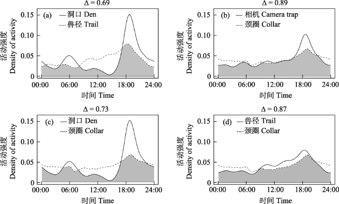
图2
不同调查方法所得荒漠猫日活动节律曲线比较。(a)安装于洞口处的相机与安装于兽径处的相机; (b)全部红外相机与颈圈; (c)安装于洞口处的相机与颈圈; (d)安装于兽径处的相机与颈圈。
Fig. 2
The daily activity curves of Chinese mountain cat estimated from (a) camera traps placed at den and trail, (b) all camera traps and satellite tracking collars, (c) camera traps placed at den and satellite tracking collars, (d) camera traps placed at trail and satellite tracking collars.
(1)对比安装在洞口处与兽径处的红外相机, 两者都在傍晚显示出较高的活动强度, 洞口的探测数据在18:00-19:00显示出更突出的活动高峰, 兽径处探测结果相对更平缓, 17:00-20:00洞口探测活动强度明显高于兽径, 9:00-16:00兽径探测活动强度明显高于洞口。日活动曲线差异显著(P < 0.01), 重叠系数为0.69 (95%置信区间为0.63-0.76) (图2a);
(2)对比全部的红外相机探测结果与卫星追踪颈圈的结果, 两种探测方法所得活动节律曲线大致走势类似, 但相机探测结果在17:00-21:00期间活动强度明显较颈圈结果有更明显的活动高峰。日活动节律曲线差异显著(P < 0.01), 两者重叠系数最高, 为0.89 (95%置信区间为0.86-0.93) (图2b);
(3)对比洞口处的红外相机探测结果与卫星追踪颈圈结果, 17:00-20:00洞口探测活动强度明显高于颈圈, 9:00-16:00颈圈活动强度明显高于洞口。活动曲线差异显著(P < 0.01), 重叠系数为0.73 (95%置信区间为0.67-0.79) (图2c);
(4)对比兽径处的红外相机探测结果与卫星追踪颈圈结果, 都显示出傍晚较高的活动强度, 9:00-20:00 (主要是白昼)兽径探测活动强度略高于颈圈, 20:00至次日9:00 (主要是夜晚)颈圈探测活动强度略高于兽径。活动曲线差异显著(P < 0.01), 重叠系数为0.87 (95%置信区间为0.81-0.93) (图2d)。
在荒漠猫的简化行为谱中, 包含2大类行为: (1)个体行为, 即行为的发生和过程只涉及个体自身的行为, 共包括10种行为类别; (2)社会行为, 即涉及2个或2个以上个体的行为, 共包括5种行为类别(表2, 附录2)。在传统行为观察法中, 全部10种个体行为(行为类别占比100%)和全部5种社会行为(100%)都可以被有效记录到, 其中除“休息”以外的9种个体行为(90%)和全部5种社会行为(100%)会被判断为目标个体处于“活跃”状态。在红外相机调查中, 放置于洞口的红外相机可以有效记录到7种个体行为(70%)和2种社会行为(即亲昵行为、母幼行为; 40%), 放置于兽径的红外相机可以有效记录到4种个体行为(即移动、取食、嗅闻、标记; 40%)而难以有效记录到社会行为(0%); 被红外相机拍摄到的动物, 无论其具体在进行何种行为, 通常全部被作为目标个体处于“活跃”状态的记录, 用于活动模式的计算。在卫星追踪颈圈记录中, 仅有3种个体行为(即移动、取食、玩耍; 30%)和1种社会行为(即攻击行为; 20%)会在颈圈的三轴加速度计中有效产生计步数据, 从而被基于计步活动量的记录归为“活跃”状态。
表2 荒漠猫简化行为谱以及各类行为是否可以在不同调查方法中被有效记录以及被判断为“活跃”状态
Table 2
| 行为类别 Behavior category | 传统行为 观察 Traditional visual observation | 洞口处红外相 机 Camera traps at den | 兽径处红外相机 Camera traps at trail | 卫星追 踪颈圈 Satellite tracking collars |
|---|---|---|---|---|
| 个体行为Individual behavior | ||||
| 1 移动 Locomotion | √, A | √, A | √, A | √, A |
| 2 休息 Rest | √, I | √, A | ×, A | ×, I |
| 3 警戒 Alert | √, A | √, A | ×, A | ×, I |
| 4 觅食 Foraging | √, A | R, A | √, A | √, A |
| 5 修饰/梳理 Maintenance | √, A | √, A | ×, A | ×, I |
| 6 排便 Defecation/Urination | √, A | R, A | R, A | ×, I |
| 7 嗅闻 Sniff | √, A | √, A | √, A | ×, I |
| 8 标记 Scent marking | √, A | √, A | √, A | ×, I |
| 9 玩耍 Play | √, A | √, A | R, A | √, A |
| 10 发声 Vocalization | √, A | R, A | ×, A | ×, I |
| 社会行为 Social behavior | ||||
| 1 亲昵行为(梳理、玩耍等) Affinitive | √, A | √, A | ×, A | R, I |
| 2 攻击行为 Aggressive | √, A | R, A | R, A | √, A |
| 3 繁殖行为 Reproductive | √, A | R, A | ×, A | R, I |
| 4 母幼行为 Mother/Infant | √, A | √, A | R, A | R, I |
| 5 其他 Other | √, A | R, A | R, A | R, I |
√: 可以被有效记录到; R: 少部分被记录到; ×: 无法被记录到; A: 被判断为“活跃”; I: 被判断为“不活跃”。
√, Can be effectively recorded; R, Can be occasionally recorded; ×, Can not be effectively recorded; A, Classified as active; I, Classified as inactive.
4 讨论
4.1 不同安装位置红外相机记录的差异
本研究红外相机探测结果表明, 荒漠猫的活动没有明显的昼夜差异, 但偏好在黄昏时段活动。当对比安装于洞口、兽径处的红外相机时, 发现两者所得活动曲线重叠系数仅为0.69, 洞口处的红外相机在晨昏两个时间段记录到较高的活动强度, 表明荒漠猫这段时间多在洞口附近活动; 而在晨昏两个时间段中间, 兽径处记录到的活动强度明显高于洞口, 这说明荒漠猫在这段时间倾向于离开洞口, 多出现于兽径处。综合不同位置的红外相机探测结果, 发现16:00-21:00的活动水平较高, 但这一时间段较高的活动主要来自洞口位点的红外相机探测数据, 这表明, 尽管荒漠猫在16:00-21:00期间明显较活跃, 但此时对它们的探测主要集中在小范围的洞口处。
本研究中, 安装在洞口处的红外相机记录到大量成体荒漠猫的休息、警戒行为, 亚成体荒漠猫的玩耍, 以及母幼行为。在繁殖期, 野生猫科动物通常使用土洞或岩石缝隙形成的洞穴作为繁殖洞, 洞穴为幼崽提供躲避不利天气和捕食者的避难所(Bleich et al, 1996; Benson et al, 2008), 也作为稳定的休息地(Zielinski et al, 2004)。自身不具备挖洞能力的中小型猫科动物如兔狲(Otocolobus manul)、荒漠猫通常会使用同域分布的喜马拉雅旱獭(Marmota himalayana)挖掘的洞穴(Ross et al, 2010; Han et al, 2020)。根据Han等(2020)使用红外相机对荒漠猫繁殖洞的观察, 12月至次年1月中旬, 当年出生的亚成体荒漠猫离洞, 2月初, 母猫离洞, 放置在洞口处的红外相机记录到大量的母幼行为及亚成体荒漠猫玩耍行为。本研究中, 除5月至次年1月外, 其他时段没有在洞口的红外相机中记录到亚成体荒漠猫, 但记录到成体荒漠猫进出洞穴、在洞口标记或嗅闻。因此安装于洞口处的红外相机数据以繁殖、育幼相关的活动模式占主导。
在兽径上放置红外相机, 常用于调查野生猫科动物, 如虎(Panthera tigris) (Lynam et al, 2009)、美洲狮(Puma concolor) (Negrões et al, 2010)、亚洲金猫(王渊等, 2019)。与随机放置红外相机相比, 安装于兽径处具有更高的探测率(Mann et al, 2015; Kolowski & Forrester, 2017)。结合红外相机记录的行为分析, 荒漠猫在兽径处的行为多为移动行为和觅食行为, 也记录到嗅闻、标记和母幼、排便行为。本研究的野外调查中, 发现荒漠猫粪便集中于兽径处, 其中某些地方会被作为多次使用的“厕所”, 虽然红外相机的记录中该行为较少。
4.2 红外相机与卫星追踪颈圈记录的差异
卫星追踪颈圈数据估算的活动曲线表明荒漠猫的日活动节律没有明显的昼夜区别, 全天都具有一定的活动强度, 在18:00-19:00活动强度稍高, 呈现一定的偏好黄昏时段活动的特征。通过对比红外相机与卫星追踪颈圈两种不同的调查方法, 发现当使用全部红外相机探测记录与卫星追踪颈圈对比时, 得到的活动曲线重叠系数最大, 为0.89。这表明, 综合不同红外相机位点的探测方式可以相对更全面地表征荒漠猫的活动量。与卫星追踪颈圈方法相比, 红外相机探测到从16:00到21:00的活动水平更高, 结合洞口与兽径的红外相机结果可知, 这一时间段对荒漠猫的探测主要集中在小范围的洞口处, 此时颈圈记录到的活动量数据偏小。这一结果与Edwards等(2021)关于棕鬣狗(Parahyaena brunnea)的研究结果类似, 包含有不同位置的红外相机数据与卫星追踪颈圈数据的重叠系数最高, 高于任一类位置的红外相机数据与卫星追踪颈圈数据重叠系数。
由本研究的结果可知, 红外相机和卫星追踪颈圈都可以作为研究野生猫科动物日活动节律的有效工具, 但由于两者获取数据的机制不同, 所得结果也会受到多种因素的影响。红外相机放置在固定区域, 可以获得拍摄区域内可能在相机前出现的物种的活动时间信息, 所拍摄到的部分照片或视频影像中可分辨出动物具体的行为类别; 但如果动物在拍摄区域外活动, 则红外相机无法探测到(Frey et al, 2017)。对于难以通过图像进行个体识别的动物, 无法获取个体的节律信息。此外, 红外相机安装是否使用诱饵、附近是否有竞争者的存在、小尺度安装位置的差异都可能导致不同的结果, 如: 放置食草动物饲料的红外相机位点会比未放置饲料的位点拍摄到更多的食草动物, 并记录到更多的觅食行为(Lashley et al, 2018); 放置在水源处的红外相机记录到几种食肉动物彼此差异出没, 体型差异大的物种表现出更大的时间生态位分离(Edwards et al, 2015); 在同一群棕鬣狗的活动范围内, 安装在其洞口和固定排泄点的红外相机记录到不同的行为及活动节律(Edwards et al, 2021)。卫星追踪颈圈佩戴在固定的个体身上, 可以不断进行采样, 不受空间限制, 记录该动物全天全部活动范围内的时间空间数据(Ensing et al, 2014)。但动物的活动节律可能存在明显的个体差异, 因此少量个体的活动数据可能无法准确表征群体的活动节律(Hertel et al, 2017)。另一方面, 颈圈只能记录动物运动状态下的活动, 如果动物的某种行为运动量较小, 颈圈则无法准确表征活动量(Edwards et al, 2021)。新一代的卫星追踪颈圈可以内置高精度三轴加速度传感器, 以记录动物运动时的三轴加速度信息。有研究发现, 高时间分辨率的加速度信息可以很好地与直接观察得到的动物不同的行为相对应, 因而被用于监测动物的行为(Brown et al, 2013)。Wang等(2015)使用三轴加速度计数据对美洲狮(Puma concolor)进行行为监测, 可分辨美洲狮的移动、休息和捕猎行为。本研究使用的颈圈中的运动传感器仅能提供简单的计步数据而缺乏精确的三轴加速度数据, 因此暂时无法对荒漠猫的活动节律进行更准确深入的研究。
4.3 其他潜在影响因素
除了调查工具的差异, 还有多种因素可能对动物的日活动节律调查结果产生影响。如: 生境类型、种群密度、性别、捕食者、猎物、人为干扰和个体差异等(Schmidt et al, 2008; Assis Morais et al, 2020; Leonard et al, 2020; Figel et al, 2021)。本研究中佩戴卫星定位颈圈的荒漠猫共10只, 其中7只为雌性, 仅有3只为雄性, 具有一定的雌性偏向。由于佩戴卫星追踪颈圈的个体数量较少, 追踪时间暂时无法覆盖全年, 我们目前无法确定荒漠猫的活动节律是否存在明显的性别差异。因此, 今后的研究应基于更长时间、更多个体的数据, 开展更加深入全面的探讨, 例如个体性别的差异、季节差异、栖息地差异等。另一方面, 通过卫星追踪颈圈展示的荒漠猫活动大致范围(附录1)可知, 荒漠猫的活动涉及造林地、农田、原生灌丛、草地等多种生境类型, 而本研究仅在荒漠猫出现频率最高的造林地中安装了红外相机, 因此, 为了获得更为全面的荒漠猫活动节律信息, 在未来研究中, 应扩大红外相机的布设范围, 尽可能全面地覆盖荒漠猫活动涉及的生境类型。尽管如此, 本研究基于目前有限的数据, 探究了不同采样方法在进行野生动物日活动节律估算时存在的差异, 并讨论了采样过程中存在的不足可能对结果产生的差异, 希望可以为未来更深入全面的野生动物研究工作提供借鉴与思考。
在以往使用红外相机进行活动节律分析的研究中, 通常认为动物被红外相机拍摄到的概率与其活动强度呈正相关, 并基于此假设进行活动节律估算(Azlan & Sharma, 2006; Li et al, 2010)。根据本研究结果可知, 红外相机受限于安装位置, 通常无法完整记录动物一天内处于活跃状态时所有的行为, 因此, 安装位置的不同可能导致记录结果由动物某一活动模式占主导, 进而无法全面地表征动物的日活动节律。因此, 该假设应建立在一个重要的前提条件上, 即选用的方法所采集的数据应尽可能地全面覆盖动物的各种行为, 使数据能够表征动物一天中全部活动的强度, 这样才能尽量准确地反映目标物种真实的活动节律。
本研究的结果显示, 直接的行为观察可以最为全面、细致地记录动物的行为类别, 准确判断各类行为是否可以作为动物的“活跃”状态, 进而客观评估目标动物的日活动节律。与行为观察相比, 红外相机难以对动物的所有行为类别进行全面有效的记录, 且调查中通常没有对所拍摄影像中动物的具体行为类别进行区分, 而是把所有拍摄的记录都作为动物处于“活跃”状态的数据, 因此所得到的日活动节律模式可能与真实情况之间存在偏差。卫星追踪颈圈将三轴加速度计的计步数据或定位点间的移动距离数据作为动物活跃程度的代理指标, 研究者无法从中识别出动物的具体行为类别, 且在动物的所有行为类别中, 这些指标仅能反映出移动、觅食等少数行为的记录, 由此所估算得到的日活动节律模式与前两种方法相比可能存在更大的偏差。然而, 传统的行为观察方法对调查人员的能力要求高, 且调查过程中受人力资源有限、调查时段有限(例如难以在夜间时段开展观察, 工作人员在野外难以长期驻留)的影响较大。红外相机和卫星追踪颈圈则凭借自动化设备的优势, 可以全天候工作, 持续采集、记录数据, 提供覆盖时间更长、样本量更大的数据集。由于红外相机与卫星追踪颈圈的工作原理不同, 基于两者调查所得的动物“日活动节律”背后的行为学和生态学含义也是不同的。因此, 在动物日活动节律和其他行为习性的研究中, 研究者都应首先对动物的行为模式和规律有深入的了解, 然后根据各调查方法的原理、特点及其适用情境, 筛选出最适合的方法或综合使用多种方法, 更加合理地设计调查方案, 并对数据做出恰当、准确的解读。在对不同方法所得的日活动节律进行对比分析时, 应注意结合调查工具的特性与动物本身的行为模式, 分析产生差异的原因, 谨慎进行对比与判断。
附录 Supplementary Material
附录1 本研究中佩戴卫星追踪颈圈的10只荒漠猫的活动范围示意图
Appendix 1 Movement range of the 10 individuals of Chinese mountain cats fitted with satellite tracking collars in this study
附录2 荒漠猫简化行为谱及各类行为的定义
Appendix 2 A simplified ethogram of Chinese mountain cats and the definition of each behavior
致谢
感谢祁连山国家公园管理局及门源回族自治县老虎沟管护站对本研究的支持。感谢祁连山国家公园青海省管理局张毓、高雅月、严频发等提供的帮助。感谢中国猫科动物保护联盟成员曾婧媛及志愿者们的辛勤付出。感谢中国农业大学金艺鹏、高宇航、石宇琦团队对荒漠猫野外捕捉的支持。感谢北京大学夏凡在数据处理中付出的努力, 刘鸣章、卜红亮、王江月在成文思路及数据分析中提供的指导和建议。
参考文献
The influence of population-control methods and seasonality on the activity pattern of wild boars (Sus scrofa) in high-altitude forests
DOI:10.1007/s42991-019-00003-y URL [本文引用: 1]
The diversity and activity patterns of wild felids in a secondary forest in Peninsular Malaysia
DOI:10.1017/S0030605306000147 URL [本文引用: 2]
Natal den selection by Florida panthers
DOI:10.2193/2007-264 URL [本文引用: 1]
Thermal characteristics of mountain lion dens
Observing the unwatchable through acceleration logging of animal behavior
DOI:10.1186/2050-3385-1-20 URL [本文引用: 1]
Application of camera-trapping data to study daily activity patterns of Galliformes in Guangdong Chebaling National Nature Reserve
DOI:10.17520/biods.2018178
[本文引用: 1]

Animal activity patterns and temporal niches can indicate the distribution of animal behavior and the utilization resources over time. Environmental variables and interspecific interactions have important effects on animal activity and temporal niche partitioning. These two factors in turn can help understand mechanisms of niche partitioning among sympatric species as well as species coexistence and community composition. Due to the extensive use and deployment of infrared cameras for nearly a decade, a large amount of time-recorded behavioral data has been accumulated. These data are conducive to studying activity rhythms and temporal niches in depth. In the present paper, we reviewed research on animal activity using infrared cameras in combination with in situ monitoring data from the Guangdong Chebaling National Nature Reserve to better understand three Galliformes species. A kernel density was used to estimate the activity and interspecific effects of a single species as well as for multispecies activity. Our study reveals a moderate overlap among Galliformes species, Lophura nycthemera, Arborophila gingica and Bambusicola thoracica, which may be caused by interspecific competition. We discuss the limitations of daily activity analyses to give a reference for similar research.
应用红外相机数据研究动物活动节律——以广东车八岭保护区鸡形目鸟类为例
DOI:10.17520/biods.2018178
[本文引用: 1]
动物活动节律和时间生态位分化是动物行为在时间维度的分布, 是对时间资源利用的重要体现。动物活动节律受到环境因素和种间作用的影响, 因此, 了解动物活动节律以及时间生态位有助于揭示群落中同域分布物种时间资源利用的差异及共存机制。近10多年来, 红外相机技术在国内外野生动物监测研究中得到广泛应用, 积累了大量有时间记录的动物行为数据, 极大地促进了动物活动节律和时间生态位分化的深入研究。本文对动物活动节律研究以及应用红外相机数据研究动物活动节律的方法进行梳理, 采用核密度估计方法, 利用广东车八岭国家级自然保护区的红外相机监测数据, 分析了鸡形目鸟类的活动节律, 以阐述单物种和多物种的活动节律以及种间作用对动物日活动节律的影响。研究结果表明车八岭保护区白鹇(Lophura nycthemera)、白眉山鹧鸪(Arborophila gingica)和灰胸竹鸡(Bambusicola thoracica)等3个鸡形目物种之间存在不同程度的竞争, 物种间的日活动节律呈现中等程度的重叠。最后, 针对动物活动节律分析方法应用的建议及影响因素进行讨论, 希望为国内动物活动节律研究提供参考。
Spatiotemporal resource partitioning of water sources by African carnivores on Namibian commercial farmlands
DOI:10.1111/jzo.12248 URL [本文引用: 1]
Are camera traps a reliable method for estimating activity patterns? A case study comparing technologies for estimating brown hyaena activity curves
DOI:10.1002/rse2.175 URL [本文引用: 8]
GPS based daily activity patterns in European red deer and North American elk (Cervus elaphus): Indication for a weak circadian clock in ungulates
Jaguars and pumas exhibit distinct spatiotemporal responses to human disturbances in Colombia’s most imperiled ecoregion
DOI:10.1093/jmammal/gyaa146 URL [本文引用: 1]
Investigating animal activity patterns and temporal niche partitioning using camera-trap data: Challenges and opportunities
DOI:10.1002/rse2.60 URL [本文引用: 1]
A review of home-range studies on Australian terrestrial vertebrates: Adequacy of studies, testing of hypotheses, and relevance to conservation and international studies
DOI:10.1071/ZO14060 URL [本文引用: 1]
Discovery of first active breeding den of Chinese mountain cat (Felis bieti)
Distribution and conservation status of the endemic Chinese mountain cat (Felis bieti)
A case for considering individual variation in diel activity patterns
DOI:10.1093/beheco/arx122
PMID:29622931
[本文引用: 1]
There is a growing recognition of the role of individual variation in patterns emerging at higher levels of biological organization. Despite the importance of the temporal configuration of ecological processes and patterns, intraspecific individual variation in diel activity patterns is almost never accounted for in behavioral studies at the population level. We used individual-based monitoring data from 98 GPS-collared brown bears in Scandinavia to estimate diel activity patterns before the fall hunting season. We extracted 7 activity measures related to timing and regularity of activity from individual activity profiles. We then used multivariate analysis to test for the existence of distinct activity tactics and their environmental determinants, followed by generalized linear regression to estimate the extent of within-individual repeatability of activity tactics. We detected 4 distinct activity tactics, with a high degree of individual fidelity to a given tactic. Demographic factors, availability of key foraging habitat, and human disturbance were important determinants of activity tactics. Younger individuals and those with higher bear and road densities within their home range were more nocturnal and more likely to rest during the day. Good foraging habitat and increasing age led to more diurnal activity patterns and nocturnal resting periods. We did not find evidence of diel activity tactics influencing survival during the subsequent hunting season. We conclude that individual variation in activity deserves greater attention than it currently receives, as it may help account for individual heterogeneity in fitness and could facilitate within-population niche partitioning that can have population- or community-level consequences.
R: A language for data analysis and graphics
Study on wild medicinal plant resource diversity in Xianmi Forest Farm of Menyuan County
门源县仙米林场野生药用植物资源多样性研究
Camera trap placement and the potential for bias due to trails and other features
Estimating wildlife activity curves: Comparison of methods and sample size
DOI:10.1038/s41598-018-22638-6
PMID:29520029
[本文引用: 6]
Camera traps and radiotags commonly are used to estimate animal activity curves. However, little empirical evidence has been provided to validate whether they produce similar results. We compared activity curves from two common camera trapping techniques to those from radiotags with four species that varied substantially in size (similar to 1 kg-similar to 50 kg), diet (herbivore, omnivore, carnivore), and mode of activity (diurnal and crepuscular). Also, we sub-sampled photographs of each species with each camera trapping technique to determine the minimum sample size needed to maintain accuracy and precision of estimates. Camera trapping estimated greater activity during feeding times than radiotags in all but the carnivore, likely reflective of the close proximity of foods readily consumed by all species except the carnivore (i.e., corn bait or acorns). However, additional analyses still indicated both camera trapping methods produced relatively high overlap and correlation to radiotags. Regardless of species or camera trapping method, mean overlap increased and overlap error decreased rapidly as sample sizes increased until an asymptote near 100 detections which we therefore recommend as a minimum sample size. Researchers should acknowledge that camera traps and radiotags may estimate the same mode of activity but differ in their estimation of magnitude in activity peaks.
Effects of sun angle, lunar illumination, and diurnal temperature on temporal movement rates of sympatric ocelots and bobcats in South Texas
Applications of camera trap in wildlife population ecology
Population parameter estimation and spatial distribution pattern are the main issues in animal ecology and conservation biology. In recent decades, camera trap as a noninvasive technique in field survey has been widely used in wildlife ecology and conservation research, and showed its great superiority under the conditions of traditional survey methods difficult to achieve. The animal presence data collected by camera trap can provide extremely valuable quantitative information on wildlife populations. In this review, the operational principles of camera trap were introduced to provide an intuitive understanding of this technique, and then, the applications of this technique in two main fields of population ecology, <em>i.e.</em>, population density and abundance estimation and spatial occupancy estimation for the species with or without natural unique individual markings, were discussed, with special attention to the logic of development, assumptions, limits in application, challenges, and future directions of model development. Finally, the important aspects which should be kept in mind when using camera trap in estimating wildlife population parameters as well as the potential capacities of camera trap in the researches of population dynamics and biodiversity, were comprehensively analyzed.
相机陷阱在野生动物种群生态学中的应用
种群参数估计及空间分布格局是动物生态学和保护生物学领域的重要目标之一.最近十几年来, 相机陷阱(camera trap)作为野外调查的一种非损伤性技术手段,在传统调查方法难以实现的情况下表现出极大优势,被广泛应用于野生动物生态学和保护学研究中.相机陷阱所获取的动物出现数据为野生动物种群提供了极其重要的定量信息.本文从相机陷阱工作原理出发,主要阐述了目前在种群生态学中较为成熟的两类针对具有或不具有天然个体标志物种的模型原理及应用: 1)种群密度和种群数量估计; 2)空间占据率估计.论文特别关注了模型发展的逻辑过程、依赖的假定、使用范围、仍然存在的问题以及未来发展方向.最后, 本文综合分析了相机陷阱在种群参数估计应用中还需注意的问题, 以及其在种群动态和生物多样性研究等方面的发展潜力.
Development progress and outlook of the wildlife camera-trapping networks in China
DOI:10.17520/biods.2020425 [本文引用: 1]
中国野生动物红外相机监测网络建设进展与展望
DOI:10.17520/biods.2020425 [本文引用: 1]
The use of infrared-triggered cameras for surveying phasianids in Sichuan Province, China
DOI:10.1111/j.1474-919X.2009.00989.x URL [本文引用: 2]
Camera-trapping in wildlife research and conservation in China: Review and outlook
DOI:10.3724/SP.J.1003.2014.14203
[本文引用: 1]
During the last two decades, infrared-triggered camera-trapping has been widely used in wildlife and biodiversity research and conservation. In the areas of wildlife ecology research, animal species inventory, biodiversity monitoring and protected area management in China, considerable outputs have been produced by scientific research and conservation applications based on camera-trapping. This technique has been successfully used to detect rare or elusive species, conduct biodiversity inventory, study animal behavior, estimate population parameters, and evaluate the effectiveness of protected area management. Along with the rapid development of modern ecological analysis and modeling tools, camera-trapping will play a more important role in wildlife research at various levels. Meanwhile, along with improvements in techniques, decreasing cost and increasing application interests, camera-trapping will be adopted by more researchers, wildlife managers and protected areas, and can be used for systematic wildlife monitoring using standard protocols. Efforts devoted to its future development and applications should focus on establishing systematically-designed monitoring networks and data-sharing protocols, and developing new analytical approaches and statistical models specifically based on camera-trapping data.
红外相机技术在我国野生动物研究与保护中的应用与前景
DOI:10.3724/SP.J.1003.2014.14203
[本文引用: 1]
20年来, 红外相机技术在国内外野生动物研究、监测与保护中得到了广泛应用。基于红外相机技术, 我国在野生动物生态学研究、动物行为学研究、稀有物种的探测与记录、动物本底资源调查、生物多样性监测及保护地管理与保护评价等领域取得了众多成果。目前, 数学模型、统计分析方法和新的概念正在促进红外相机技术在野生动物监测研究与保护管理中的发展和推广应用。同时, 随着红外相机技术的成熟、成本降低和应用普及, 这一技术也将会被更多的野生动物研究人员、管理人员和自然保护区管理者所采用, 并成为全国各级保护地和区域生物多样性监测研究的关键技术和方法。今后, 建立并完善系统化的监测网络和数据共享平台、开发新一代的数据分析方法与模型, 将是此项技术进一步发展和应用的主要方向。
Some biological informations of desert cat in Qinghai
The Chinese desert cat (<i>Fells bieti</i>,MiIne-Edwards) lives in six different habitats in Qinghai province at an elevation of 2,800-4,100m,i.e.alpine meadow, alpine bush,edge of coniferous forest, grassy meadow, desert-semi desert zone and loess hill steppes.The desert cat occurs in Huangzhong and other 18 counties (suburb) in Qinghai, frequently in Huangzhong,Huangyuan,Menyuan, Qilian,Tongren and Dulan.The den of desert cat can be found in natural rocky cave on sunny slope between 3,000-3, 600m.There are breeding dens and temporary ones.The desert cat moves actively in morning,evening and at night.It lives a solitary life except in mating season.In breeding period, activity range of the female is limited and fixed. The main food is rodents, when lacking in winter, it preys on birds.
青海荒漠猫的一些生物学资料
本文对荒漠猫(Felis bieti)的形态、野外栖息环境、洞穴和捕食活动、食性等作了实地调查,同时结合西宁人民公园人工饲养荒漠猫的行为观察,综合整理的生物学初步观察资料。
Estimating abundance with sparse data: Tigers in northern Myanmar
DOI:10.1007/s10144-008-0093-5 URL [本文引用: 1]
The road less travelled: Assessing variation in mammal detection probabilities with camera traps in a semi-arid biodiversity hotspot
DOI:10.1007/s10531-014-0834-z URL [本文引用: 1]
The success of GPS collar deployments on mammals in Australia
DOI:10.1071/AM12021 URL [本文引用: 1]
Use of camera-trapping to estimate puma density and influencing factors in central Brazil
DOI:10.1111/j.1937-2817.2010.tb01240.x URL [本文引用: 1]
camtrapR: An R package for efficient camera trap data management
DOI:10.1111/2041-210X.12600 URL [本文引用: 1]
Habitat patch size modulates terrestrial mammal activity patterns in Amazonian forest fragments
DOI:10.1644/09-MAMM-A-199.1 URL [本文引用: 1]
Seasonality and human disturbance alter brown bear activity patterns: Implications for circumpolar carnivore conservation?
DOI:10.1111/acv.12284 URL [本文引用: 1]
R: A Language and Environment for Statistical Computing
Estimating overlap of daily activity patterns from camera trap data
DOI:10.1198/jabes.2009.08038 URL [本文引用: 5]
Felis bieti
Den-site selection is critical for Pallas’s cats
(Otocolobus manul).DOI:10.1139/Z10-056 URL [本文引用: 1]
Activity: Animal Activity Statistics
The reproductive tactics and activity patterns of solitary carnivores: The Iriomote cat
DOI:10.1007/s10164-008-0101-4 URL [本文引用: 1]
Spatiotemporal relationships between snow leopard (Panthera uncia) and red fox (Vulpes vulpes) in Qionglai Mountains, Sichuan Province
四川邛崃山脉雪豹与赤狐时空生态位关系
DOI:10.16829/j.slxb.150475
[本文引用: 1]
食肉动物是生态系统中关键的功能类群,探究顶级捕食者和次级捕食者的种间作用和共存机制有助于我们深入理解生态系统变化和物种种群动态变化的驱动机制,是目前全球大型兽类种群衰退背景下的重要议题。在动物物种生态位的诸多维度中,空间与时间生态位是其中最为关键的两个维度,了解同域分布物种之间在时、空生态位上的相互关系是探究物种共存机制的基础。本研究以邛崃山脉中部的卧龙国家级自然保护区为研究区域,使用红外相机技术与粪便DNA技术在区内的高山生境开展野外调查,收集雪豹(Panthera uncia,分布点数量n=198)与赤狐(Vulpes vulpes,n=68)的分布数据,分别使用MaxEnt物种分布模型和日活动模式分析来探究区内雪豹和赤狐在时、空生态位上的相互作用关系。结果显示,在空间上,研究区域内雪豹和赤狐的潜在适宜分布区重叠面积404.08 km<sup>2</sup>,主要集中在保护区西北部的高海拔区域,分别占二者适宜栖息地总面积的77.74%和80.79%,重叠程度较高;在垂直分布上,区内雪豹分布的平均海拔较赤狐稍高,赤狐的海拔分布范围较雪豹稍广,但两物种在垂直方向上的重叠程度也较高,均在海拔4 300 m左右出现分布高峰。在时间生态位上,雪豹(独立探测数n=351)与赤狐(n=155)的日活动模式均为双峰型,雪豹偏向晨昏性而赤狐更偏向夜行性,整体上二者日活动节律重叠度较高(Δ=0.68);在有雪豹活动的位点上以及两周内曾有雪豹活动的情况下,赤狐会加强夜间活动,降低其日活动节律与雪豹之间的重叠程度,但其日活动模式未有显著改变。本研究的结果初步揭示了雪豹与赤狐的时空生态位关系,将为深入理解高山生态系统中顶级捕食者与次级捕食者的共存机制提供实例与基础信息,同时也将为保护区针对这些食肉动物种群的精细化管理提供支持。
A standardized ethogram for the Felidae: A tool for behavioral researchers
DOI:10.1016/j.applanim.2015.04.001 URL [本文引用: 1]
Coat pattern variation and activity rhythm of Asiatic golden cat (Catopuma temminckii) in Yarlung Zangbo Grand Canyon National Nature Reserve of Tibet, China
DOI:10.17520/biods.2019070
[本文引用: 2]
From 2013 to 2018 we conducted camera-trapping surveys on the elusive Asiatic golden cat (Catopuma temminckii) in Yarlung Zangbo Grand Canyon National Nature Reserve, Tibet. With an extensive survey effort of 14,071 camera-days at 70 camera stations, we obtained 101 independent detections of Asiatic golden cat, of which 60 (59.4%) were captured during day time and used to identify the coat markings of each captured individual. Four types of coat variations were detected and defined. The capture rates were: 46 common form, 7 red form, 4 melanistic form, and 3 gray form. The gray form was the first ever record in China. Results indicate that individuals of different forms could be co-existing and southeast Tibet has the most diverse coat variations of Asiatic golden cat in China. We described the morphological characteristics shared among and between the different forms, which will provide a sound foundation for further research on this species. The Asiatic golden cats in the study area showed a diurnal activity rhythm with the highest activity peak between 10:00 and 12:00. There were significant differences in daily-discrepancy index α and diurnal-nocturnal index β in different months and the activity intensity and peak patterns had obvious seasonal changes. This study has accumulated basic data for wildlife inventory of the East Himalayan biodiversity hotspot, and also provided basic information and reference for subsequent research on the mechanisms determining coat variations of felid species.
西藏雅鲁藏布大峡谷国家级自然保护区金猫的色型类别与活动节律
DOI:10.17520/biods.2019070
[本文引用: 2]
2013-2018年间采用红外相机技术对西藏雅鲁藏布大峡谷国家级自然保护区的金猫(Catopuma temminckii)进行长期监测, 累计布设70个点位, 14,071个相机工作日。共收集金猫独立照片101张, 其中60张可识别色型, 占金猫独立照片总数的59.40%。共记录到4种不同色型的金猫个体, 拍摄频次比例为麻褐色型:红棕色型:黑色型:灰色型 = 46:7:4:3; 其中灰色型为我国野生金猫实体首次记录。不同色型的个体可同域分布, 而以雅鲁藏布大峡谷自然保护区为代表的藏东南地区是我国金猫色型变异最丰富的地区。基于红外相机照片对金猫的共性形态特征和不同色型的独特形态特征进行了详细的图文描述, 以期为该物种的深入研究提供详实的基础资料。活动节律的分析结果显示, 研究区内金猫以昼行性活动为主, 10:00-12:00为其最强的活动高峰。不同月份的日活动差异指数(daily-discrepancy index) α和昼行性指数(diurnal-nocturnal index) β均存在显著差异, 且活动强度具有明显的季节性变化, 不同季节的活动峰型存在显著差异。本研究为东喜马拉雅生物多样性热点区动物多样性本底的完善积累了基础资料, 也为后续的猫科动物色型多样性的形成机制研究提供了基础信息与参考。
Movement, resting, and attack behaviors of wild pumas are revealed by tri-axial accelerometer measurements
DOI:10.1186/s40462-015-0030-0
PMID:25709837
[本文引用: 1]
Accelerometers are useful tools for biologists seeking to gain a deeper understanding of the daily behavior of cryptic species. We describe how we used GPS and tri-axial accelerometer (sampling at 64 Hz) collars to monitor behaviors of free-ranging pumas (Puma concolor), which are difficult or impossible to observe in the wild. We attached collars to twelve pumas in the Santa Cruz Mountains, CA from 2010-2012. By implementing Random Forest models, we classified behaviors in wild pumas based on training data from observations and measurements of captive puma behavior.We applied these models to accelerometer data collected from wild pumas and identified mobile and non-mobile behaviors in captive animals with an accuracy rate greater than 96%. Accuracy remained above 95% even after downsampling our accelerometer data to 16 Hz. We were further able to predict low-acceleration movement behavior (e.g. walking) and high-acceleration movement behavior (e.g. running) with 93.8% and 92% accuracy, respectively. We had difficulty predicting non-movement behaviors such as feeding and grooming due to the small size of our training dataset. Lastly, we used model-predicted and field-verified predation events to quantify acceleration characteristics of puma attacks on large prey.These results demonstrate that accelerometers are useful tools for classifying the behaviors of cryptic medium and large-sized terrestrial mammals in their natural habitats and can help scientists gain deeper insight into their fine-scale behavioral patterns. We also show how accelerometer measurements can provide novel insights on the energetics and predation behavior of wild animals. Lastly we discuss the conservation implications of identifying these behavioral patterns in free-ranging species as natural and anthropogenic landscape features influence animal energy allocation and habitat use.
Catalogue of mammals in China (2021)
中国兽类名录(2021版)
DOI:10.16829/j.slxb.150595
[本文引用: 1]
中国是全球兽类物种多样性最高的国家之一,掌握我国兽类物种多样性和分类地位是兽类学研究的基础前提,也是科学保护野生种群的前提。为厘清中国兽类的物种数量及分类地位等关键分类学信息,中国动物学会兽类学分会组织国内长期致力于兽类各类群分类的科学研究人员,在总结前人研究的基础上,根据最新的形态学和分子遗传学证据,综合现代兽类分类学家意见,经编委会充分讨论,形成了最新的中国兽类名录,包括我国现阶段兽类12目59科254属686种。该中国兽类名录使用基于系统发生关系的分类系统,并对物种有效性进行了充分慎重的确认和讨论。
Applications of camera trapping to wildlife surveys in China
DOI:10.3724/SP.J.1003.2014.14244 [本文引用: 1]
红外相机技术在我国野生动物监测研究中的应用
DOI:10.3724/SP.J.1003.2014.14244 [本文引用: 1]
Genomic evidence for the Chinese mountain cat as a wildcat conspecific (Felis silvestris bieti) and its introgression to domestic cats
Taxonomic and systematic research progress of mammals in China
DOI:10.16829/j.slxb.150535
[本文引用: 1]
Rich mammalian diversity in China ranks it as one of the key groups in maintaining ecological function. Since Mr. John R. Reeves conducted the first mammalian survey in Guangdong, China, from 1829 to 1834, Chinese mammal taxonomic and systematic researches have made remarkable progress in the past 200 years. Presently, the number of mammal species in China has reached 686, representing about 10% of all mammals and making it one of the most diverse countries in mammal species in the world. As China attaches greater importance to ecological protection, the ecological environment is increasingly improved. Nevertheless, along with global climate change, increasing human activities and the emergence of major human-animal epidemics, the importance of mammal surveys and taxonomic clarification has become more apparent. Meanwhile, this traditional discipline is constantly incorporating state-of-art techniques, such as integrative taxonomy, digitization of specimens, type specimens sequencing technique, portable sequencing techniques and deep learning-based species identification, with the goals of verifying species identification, building proper taxonomic classifications, and promoting the application and transformation of taxonomic achievements to other discipline. Animal taxonomy, a traditional basic discipline, is also the basis for many branches in modern biology, such as genetics, physiology, ecology, medicine and pharmacology. However, due to distinct characteristics among disciplines, it has not received sufficient attention in recent years. It is thus necessary to value traditional taxonomy, morphology and other basic disciplines at the national level, and provide special policy and financial support on talent training and funding.
中国兽类分类与系统演化研究进展
DOI:10.16829/j.slxb.150535
[本文引用: 1]
中国兽类(即哺乳动物)种类繁多,对维持生态平衡发挥着重要的作用。自John R.Reeves于1829—1834年在我国广东开展兽类调查以来,近200年我国兽类分类及系统学研究取得了令世人瞩目的进步和发展。目前中国已知的兽类物种数已达686种,约占全世界兽类种数的10%,是世界上兽类物种多样性最丰富的国家之一。随着我国对生态环境保护的重视,生态环境日益改善,但全球气候变化、生境破碎化、人类活动增加及人兽共患重大疫情涌现等问题仍十分突出,兽类多样性调查及分类学研究的必要性越发明显。同时,兽类分类学这门古老而传统的学科也在不断引入各种新方法与技术,如整合分类学、标本数字化、模式标本测序、便携式测序技术及基于深度学习技术的物种识别鉴定等,分类学研究的成果及应用在近年得到了飞速发展。动物分类学作为传统的基础学科,是遗传学、生理学、生态学、医学、药学等现代生物学的基石。然而,由于学科特征和差异等原因,该学科近年来没有得到足够的重视,导致出现了学科萎缩和分类学人才后继无人的危机。因此,从国家层面对分类学、形态学等基础学科的人才培养、课题设置和资金投入等,予以特殊的政策支持,十分必要,也亟待解决。
Daily activity rhythm of Lthaginis cruentus in the Wanglang National Nature Reserve, Sichuan
四川王朗国家级自然保护区血雉的日活动节律
Resting habitat selection by fishers in California
DOI:10.2193/0022-541X(2004)068[0475:RHSBFI]2.0.CO;2 URL [本文引用: 1]
Seasonal variation of daily activity patterns and diet of yellow-throated marten
(Martes flavigula).
黄喉貂日活动节律及食性的季节变化
