


1 观测网络简介
近年来, 红外相机作为一种非损伤性的野生动物观测方法, 已成为生物多样性调查和观测的重要工具和动物生态学研究的重要手段, 广泛应用于我国大中型哺乳动物观测研究, 并取得了重要进展(赵玉泽等, 2013; 贾晓东等, 2014; 宋大昭等, 2014;肖治术, 2016)。红外相机具有较明显的优越性, 如: 能在恶劣的环境中昼夜连续工作, 进行长期观测; 通过获得各种动物的真实图像确认物种的存在, 可实现区域内动物多样性的快速评价; 对大中型哺乳动物, 行踪诡秘、夜行性、稀有物种以及外形易于识别的物种更加有效(李晟等, 2014)。
中国哺乳动物多样性观测网络(China BON- Mammal, 下文简称“观测网络”)于2016年底启动, 由生态环境部作为牵头主管部门, 南京环境科学研究所作为牵头单位, 40家科研院所、高等院校、自然保护区等单位共同参与网络建设与观测活动实施。观测网络旨在掌握我国陆生大中型哺乳动物的种类、数量、分布以及人为干扰情况, 评估全国大中型哺乳动物种群动态变化趋势, 分析环境变化及人类活动对野生动物多样性变化的影响和生物多样性保护成效, 并为制定全国生物多样性保护相关管理措施和政策提供技术支撑。观测对象主要为陆生大中型哺乳动物, 同时兼顾鸡形目等地栖性鸟类。截至2019年底, 观测网络已在全国18个省(直辖市、自治区)以县域为单元, 选择代表性保护地建立了74个哺乳动物观测样区(sample regions), 包括浙江清凉峰、江西武夷山、湖北神农架、广东鼎湖山、陕西长青、甘肃祁连山、青海三江源等(表1, 图1), 共设置222个样地(sample plots), 布设4,400余台红外相机。在国内及全球以红外相机技术为核心的观测网络平台中, 本观测网络的规模均较大。整个观测网络的运行由生态环境部南京环境科学研究所负责总体协调和组织实施, 包括制定统一的观测方案和技术规范, 开展观测人员技术培训, 与各样区进行协调和沟通, 掌握工作状态, 管理数据质量, 对各观测样区的数据进行汇总和分析。参与观测网络的单位共计39家, 涉及53位项目负责人, 分别负责各个样区内观测工作的实施, 参与观测人员约500名。
表1 中国哺乳动物多样性观测网络红外相机观测样区基本信息表(截至2019年底)
Table 1
| 样区编号 Sample region no. | 样区名称 Sample region name | 省区 Province | 保护地级别 Protective status | 面积 Area (km2) | 中心经度 Central longitude (E) | 中心纬度 Central latitude (N) | 起始年份 Start year | 结束年份 End year | 网格大小 Grid size | 有效相机 位点 Effective camera site |
|---|---|---|---|---|---|---|---|---|---|---|
| 1 | 八仙山 BXS | 天津市 Tianjin | 国家级保护区 National reserve | 53.60 | 117.56° | 40.19° | 2019 | 2019 | 1 km × 1 km | 60 |
| 2 | 小五台山 XWTS | 河北省 Hebei | 国家级保护区 National reserve | 218.33 | 115.39° | 39.98° | 2019 | 2019 | 1 km × 1 km | 60 |
| 3 | 驼梁 TL | 河北省 Hebei | 国家级保护区 National reserve | 213.11 | 113.82° | 38.72° | 2019 | 2019 | 1 km × 1 km | 60 |
| 4 | 清凉峰 QLF | 浙江省 Zhejiang | 国家级保护区 National reserve | 108.00 | 118.91° | 30.11° | 2017 | 2019 | 1 km × 1 km | 60 |
| 5 | 括苍山 KCS | 浙江省 Zhejiang | 省级保护区 Provincial reserve | 27.01 | 120.94° | 28.81° | 2017 | 2019 | 1 km × 1 km | 60 |
| 6 | 钱江源 QJY | 浙江省 Zhejiang | 国家公园 National park | 252.00 | 118.42° | 29.15° | 2017 | 2019 | 1 km × 1 km | 60 |
| 7 | 百山祖 BSZ | 浙江省 Zhejiang | 国家级保护区 National reserve | 108.80 | 119.17° | 27.69° | 2017 | 2019 | 1 km × 1 km | 60 |
| 8 | 乌岩岭 WYL | 浙江省 Zhejiang | 国家级保护区 National reserve | 188.62 | 119.30° | 28.30° | 2017 | 2019 | 1 km × 1 km | 60 |
| 9 | 牯牛降 GNJ | 安徽省 Anhui | 国家级保护区 National reserve | 67.13 | 117.54° | 30.02° | 2017 | 2019 | 1 km × 1 km | 60 |
| 10 | 黄山 HS | 安徽省 Anhui | 风景名胜区 Scenic area | 160.60 | 118.12° | 30.15° | 2017 | 2019 | 1 km × 1 km | 60 |
| 11 | 大别山 DBS | 安徽省 Anhui | 国家级保护区 National reserve | 123.00 | 116.09° | 30.99° | 2017 | 2019 | 1 km × 1 km | 60 |
| 样区编号 Sample region no. | 样区名称 Sample region name | 省区 Province | 保护地级别 Protective status | 面积 Area (km2) | 中心经度 Central longitude (E) | 中心纬度 Central latitude (N) | 起始年份 Start year | 结束年份 End year | 网格大小 Grid size | 有效相机 位点 Effective camera site |
| 12 | 戴云山 DYS | 福建省 Fujian | 国家级保护区 National reserve | 134.72 | 118.24° | 25.66° | 2017 | 2019 | 1 km × 1 km | 60 |
| 13 | 九岭山 JLS | 江西省 Jiangxi | 国家级保护区 National reserve | 115.41 | 115.34° | 29.04° | 2017 | 2019 | 1 km × 1 km | 60 |
| 14 | 齐云山 QYS | 江西省 Jiangxi | 国家级保护区 National reserve | 171.10 | 114.08° | 25.79° | 2017 | 2019 | 1 km × 1 km | 60 |
| 15 | 桃红岭 THL | 江西省 Jiangxi | 国家级保护区 National reserve | 125.00 | 116.60° | 29.78° | 2017 | 2019 | 1 km × 1 km | 60 |
| 16 | 武夷山 WYS | 江西省 Jiangxi | 国家级保护区 National reserve | 160.07 | 117.71° | 28.30° | 2017 | 2019 | 1 km × 1 km | 60 |
| 17 | 九连山 JLS | 江西省 Jiangxi | 国家级保护区 National reserve | 134.11 | 114.58° | 24.68° | 2018 | 2019 | 1 km × 1 km | 60 |
| 18 | 宜黄 YH | 江西省 Jiangxi | 省级保护区 Provincial reserve | 583.00 | 116.24° | 27.56° | 2019 | 2019 | 1 km × 1 km | 60 |
| 19 | 神农架 SNJ | 湖北省 Hubei | 国家公园 National park | 704.67 | 110.00° | 31.47° | 2017 | 2019 | 1 km × 1 km | 60 |
| 20 | 后河 HH | 湖北省 Hubei | 国家级保护区 National reserve | 103.40 | 110.58° | 30.12° | 2017 | 2019 | 1 km × 1 km | 60 |
| 21 | 七姊妹山 QZMS | 湖北省 Hubei | 国家级保护区 National reserve | 611.28 | 109.67° | 29.92° | 2017 | 2019 | 1 km × 1 km | 60 |
| 22 | 雪峰山 XFS | 湖南省 Hunan | 国家级保护区 National reserve | 130.00 | 110.28° | 27.17° | 2017 | 2019 | 1 km × 1 km | 60 |
| 23 | 莽山 MS | 湖南省 Hunan | 国家级保护区 National reserve | 198.33 | 112.79° | 24.99° | 2017 | 2019 | 1 km × 1 km | 60 |
| 24 | 壶瓶山 HPS | 湖南省 Hunan | 国家级保护区 National reserve | 665.68 | 110.80° | 30.06° | 2017 | 2019 | 1 km × 1 km | 60 |
| 25 | 大围山 DWS | 湖南省 Hunan | 国家级保护区 National reserve | 439.93 | 114.13° | 28.43° | 2017 | 2019 | 1 km × 1 km | 60 |
| 26 | 都庞岭 DPL | 湖南省 Hunan | 国家级保护区 National reserve | 200.66 | 111.37° | 25.51° | 2017 | 2019 | 1 km × 1 km | 60 |
| 27 | 八大公山 BDGS | 湖南省 Hunan | 国家级保护区 National reserve | 234.68 | 110.16° | 29.40° | 2017 | 2019 | 1 km × 1 km | 60 |
| 28 | 鼎湖山 DHS | 广东省 Guangdong | 国家级保护区 National reserve | 90.94 | 112.53° | 23.17° | 2017 | 2019 | 1 km × 1 km | 60 |
| 29 | 车八岭 CBL | 广东省 Guangdong | 国家级保护区 National reserve | 75.45 | 114.27° | 24.73° | 2017 | 2019 | 1 km × 1 km | 60 |
| 30 | 南岭 NL | 广东省 Guangdong | 国家级保护区 National reserve | 584.00 | 113.07° | 24.89° | 2017 | 2019 | 1 km × 1 km | 60 |
| 31 | 云开山 YKS | 广东省 Guangdong | 国家级保护区 National reserve | 125.11 | 111.26° | 22.27° | 2017 | 2019 | 1 km × 1 km | 60 |
| 32 | 岑王老山 CWLS | 广西省 Guangxi | 国家级保护区 National reserve | 189.94 | 106.66° | 23.89° | 2017 | 2019 | 1 km × 1 km | 60 |
| 33 | 大瑶山 DYS | 广西省 Guangxi | 国家级保护区 National reserve | 255.95 | 110.08° | 24.00° | 2017 | 2019 | 1 km × 1 km | 60 |
| 34 | 弄岗 NG | 广西省 Guangxi | 国家级保护区 National reserve | 101.00 | 106.95° | 22.50° | 2017 | 2019 | 1 km × 1 km | 60 |
| 35 | 崇左 CZ | 广西省 Guangxi | 国家级保护区 National reserve | 255.78 | 107.38° | 22.57° | 2017 | 2019 | 1 km × 1 km | 60 |
| 36 | 猫儿山 MES | 广西省 Guangxi | 国家级保护区 National reserve | 170.00 | 110.41° | 25.81° | 2017 | 2018 | 1 km × 1 km | 60 |
| 37 | 邦亮 BL | 广西省 Guangxi | 国家级保护区 National reserve | 65.30 | 106.37° | 22.89° | 2017 | 2019 | 1 km × 1 km | 60 |
| 样区编号 Sample region no. | 样区名称 Sample region name | 省区 Province | 保护地级别 Protective status | 面积 Area (km2) | 中心经度 Central longitude (E) | 中心纬度 Central latitude (N) | 起始年份 Start year | 结束年份 End year | 网格大小 Grid size | 有效相机 位点 Effective camera site |
| 38 | 大巴山 DBS | 重庆市 Chongqing | 国家级保护区 National reserve | 1,360.17 | 109.01° | 31.83° | 2017 | 2019 | 1 km × 1 km | 60 |
| 39 | 缙云山 JYS | 重庆市 Chongqing | 国家级保护区 National reserve | 76.00 | 106.40° | 29.84° | 2017 | 2019 | 1 km × 1 km | 60 |
| 40 | 金佛山 JFS | 重庆市 Chongqing | 国家级保护区 National reserve | 418.50 | 107.35° | 29.03° | 2017 | 2019 | 1 km × 1 km | 60 |
| 41 | 王朗 WL | 四川省 Sichuan | 国家级保护区 National reserve | 323.00 | 104.16° | 32.92° | 2017 | 2019 | 1 km × 1 km | 60 |
| 42 | 贡嘎山 GGS | 四川省 Sichuan | 国家级保护区 National reserve | 4,091.44 | 101.80° | 29.51° | 2017 | 2019 | 1 km × 1 km | 60 |
| 43 | 米亚罗 MYL | 四川省 Sichuan | 国家级保护区 National reserve | 1,607.32 | 102.82° | 31.61° | 2018 | 2019 | 1 km × 1 km | 60 |
| 44 | 格西沟 GXG | 四川省 Sichuan | 国家级保护区 National reserve | 228.97 | 101.00° | 30.04° | 2017 | 2019 | 1 km × 1 km | 60 |
| 45 | 卧龙 WL | 四川省 Sichuan | 国家级保护区 National reserve | 2,000.00 | 103.08° | 31.06° | 2017 | 2019 | 1 km × 1 km | 60 |
| 46 | 亚丁 YD | 四川省 Sichuan | 国家级保护区 National reserve | 1,233.04 | 100.35° | 28.46° | 2017 | 2019 | 1 km × 1 km | 60 |
| 47 | 白河 BH | 四川省 Sichuan | 省级保护区 Provincial reserve | 160.00 | 104.16° | 33.31° | 2017 | 2019 | 1 km × 1 km | 60 |
| 48 | 麻阳河 MYH | 贵州省 Guizhou | 国家级保护区 National reserve | 311.13 | 108.34° | 28.68° | 2017 | 2019 | 1 km × 1 km | 60 |
| 49 | 茂兰 ML | 贵州省 Guizhou | 国家级保护区 National reserve | 212.85 | 108.07° | 25.26° | 2017 | 2019 | 1 km × 1 km | 60 |
| 50 | 宽阔水 KKS | 贵州省 Guizhou | 国家级保护区 National reserve | 262.31 | 107.16° | 28.22° | 2017 | 2019 | 1 km × 1 km | 60 |
| 51 | 梵净山 FJS | 贵州省 Guizhou | 国家级保护区 National reserve | 419.00 | 108.69° | 27.91° | 2017 | 2019 | 1 km × 1 km | 60 |
| 52 | 赤水 CS | 贵州省 Guizhou | 国家级保护区 National reserve | 133.00 | 106.00° | 28.38° | 2017 | 2019 | 1 km × 1 km | 60 |
| 53 | 坡岗 PG | 贵州省 Guizhou | 省级保护区 Provincial reserve | 167.58 | 104.98° | 24.95° | 2017 | 2019 | 1 km × 1 km | 60 |
| 54 | 白马雪山 BMXS | 云南省 Yunnan | 国家级保护区 National reserve | 2,821.06 | 99.09° | 28.34° | 2017 | 2019 | 1 km × 1 km | 60 |
| 55 | 高黎贡山 GLGS | 云南省 Yunnan | 国家级保护区 National reserve | 4,052.00 | 98.74° | 25.30° | 2017 | 2018 | 1 km × 1 km | 60 |
| 56 | 无量山 WLS | 云南省 Yunnan | 国家级保护区 National reserve | 313.13 | 100.70° | 24.46° | 2017 | 2019 | 1 km × 1 km | 60 |
| 57 | 纳板河 NBH | 云南省 Yunnan | 国家级保护区 National reserve | 266.00 | 100.66° | 22.25° | 2017 | 2018 | 1 km × 1 km | 60 |
| 58 | 西双版纳 XSBN | 云南省 Yunnan | 国家级保护区 National reserve | 1,035.83 | 100.40° | 22.04° | 2017 | 2018 | 1 km × 1 km | 60 |
| 59 | 太阳河 TYH | 云南省 Yunnan | 省级保护区 Provincial reserve | 70.35 | 101.13° | 22.58° | 2017 | 2018 | 1 km × 1 km | 60 |
| 60 | 南滚河 NGH | 云南省 Yunnan | 国家级保护区 National reserve | 508.87 | 99.25° | 23.15° | 2017 | 2019 | 1 km × 1 km | 60 |
| 61 | 黄连山 HLS | 云南省 Yunnan | 国家级保护区 National reserve | 650.58 | 102.21° | 22.85° | 2017 | 2018 | 1 km × 1 km | 60 |
| 62 | 老山 LS | 云南省 Yunnan | 省级保护区 Provincial reserve | 205.00 | 104.61° | 22.95° | 2017 | 2018 | 1 km × 1 km | 60 |
| 63 | 牛背梁 NBL | 陕西省 Shaanxi | 国家级保护区 National reserve | 164.18 | 108.84° | 33.79° | 2017 | 2018 | 1 km × 1 km | 60 |
| 样区编号 Sample region no. | 样区名称 Sample region name | 省区 Province | 保护地级别 Protective status | 面积 Area (km2) | 中心经度 Central longitude (E) | 中心纬度 Central latitude (N) | 起始年份 Start year | 结束年份 End year | 网格大小 Grid size | 有效相机 位点 Effective camera site |
| 64 | 天竺山 TZS | 陕西省 Shaanxi | 省级保护区 Provincial reserve | 216.85 | 110.04° | 33.40° | 2017 | 2019 | 1 km × 1 km | 60 |
| 65 | 长青 CQ | 陕西省 Shaanxi | 国家级保护区 National reserve | 300.00 | 107.60° | 33.60° | 2017 | 2019 | 1 km × 1 km | 60 |
| 66 | 子午岭 ZWL | 陕西省 Shaanxi | 国家级保护区 National reserve | 406.21 | 108.70° | 35.93° | 2017 | 2019 | 1 km × 1 km | 60 |
| 67 | 佛坪 FP | 陕西省 Shaanxi | 国家级保护区 National reserve | 350.00 | 108.03° | 33.70° | 2017 | 2019 | 1 km × 1 km | 60 |
| 68 | 安西 AX | 甘肃省 Gansu | 国家级保护区 National reserve | 8,000.00 | 95.78° | 40.52° | 2017 | 2019 | 1 km × 1 km | 60 |
| 69 | 连城 LC | 甘肃省 Gansu | 国家级保护区 National reserve | 479.30 | 102.85° | 36.73° | 2017 | 2019 | 1 km × 1 km | 60 |
| 70 | 莲花山 LHS | 甘肃省 Gansu | 国家级保护区 National reserve | 125.51 | 103.77° | 34.95° | 2017 | 2019 | 1 km × 1 km | 60 |
| 71 | 祁连山 QLS | 甘肃省 Gansu | 国家级保护区 National reserve | 26,530.00 | 102.60° | 37.45° | 2017 | 2018 | 1 km × 1 km | 60 |
| 72 | 三江源 SJY | 青海省 Qinghai | 国家级保护区 National reserve | 318,000.00 | 97.25° | 33.01° | 2017 | 2019 | 1 km × 1 km | 60 |
| 73 | 都兰 DL | 青海省 Qinghai | - | 46.27 | 98.42° | 35.67° | 2017 | 2018 | 1 km × 1 km | 60 |
| 74 | 六盘山 LPS | 宁夏自治区 Ningxia | 国家级保护区 National reserve | 678.00 | 106.30° | 35.37° | 2017 | 2019 | 1 km × 1 km | 60 |
图1
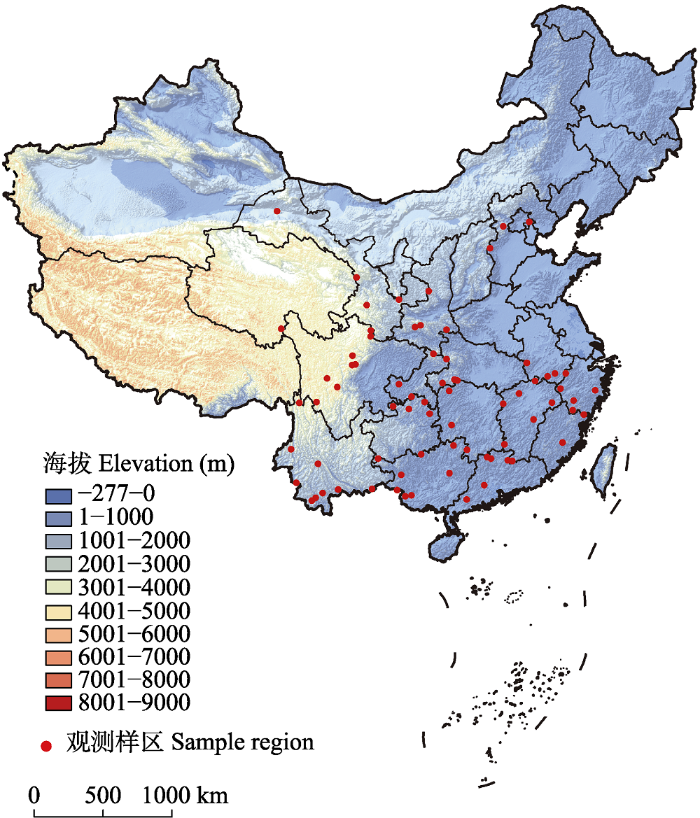
图1
中国哺乳动物多样性观测网络内观测样区分布图
Fig. 1
The map of sample regions within the China mammal diversity observation network
2 观测方案
观测网络的方案设计遵循科学性、可操作性、持续性和系统性原则, 在空间和成本上对观测样区进行有效分配。从物种和生态系统两个层面考虑样区的选择, 重点关注旗舰物种、保护伞物种、濒危物种、经济物种, 以及重要生态系统类型。以代表性自然保护区为重点, 兼顾珍稀濒危物种、国家重点保护物种的核心分布区, 覆盖哺乳动物地理分布的重点区域, 统筹考虑已有观测工作基础的地区, 在全国选择以县域为单元的观测样区, 形成全国哺乳动物多样性观测网络。
每个观测样区根据海拔、植被类型、人为活动干扰强度和野生动物分布的先验知识, 选取3个观测样地, 每个样地面积为20 km2, 样地间原则上保持大于3 km的间距。利用地理信息系统(ArcGIS)软件将每个观测样地划分成20个1 km × 1 km的网格, 作为野外观测的地理参照, 观测网格之间尽量保持连续形态(图2)。
图2
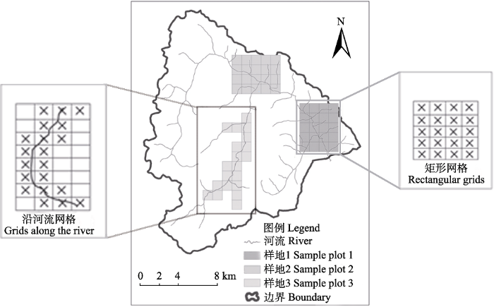
图2
观测样区内样地选择与红外相机布设示意图(示例样区以四川王朗国家级自然保护区为例)
Fig. 2
The distribution of sample plots within a sample region (e.g. Wanglang National Nature Reserve, Sichuan Province)
每个网格内放置1台红外相机, 相邻网格的相机之间至少相距500 m。相机位点一般选择人为干扰较小、适宜大中型哺乳动物觅食栖息的地点, 如河流水源地、兽道、山脊等动物痕迹较多的地方。对每台相机进行定位和编号, 同时记录生境信息。各样区根据实际情况定期对相机进行维护, 在保证相机数据记录完整和电池用量充足的前提下, 每3-4个月换1次相机存储卡和电池, 收集存储卡中的图像和视频数据。
3 观测数据库介绍
为了能高效地处理红外相机图像数据, 将其规范地存储和管理, 促进全国哺乳动物多样性观测数据的网络化和信息化, 本观测网络通过建立和开发全国哺乳动物多样性观测信息数据库, 实现数据的实时传输、网络化管理、长期有效存储, 进一步形成全国哺乳动物多样性观测网络的公共信息平台。
2017年, 生态环境部南京环境科学研究所自主研发了全国哺乳类观测数据库(
4 物种名录
截至2019年底, 观测网络平台已收集到原始照片接近6 TB, 共200多万张照片, 其中有效照片(即拍摄到动物或人的照片)约30万张, 已全部完成鉴定。主要参考《中国兽类野外手册》(Smith和解焱, 2009)、《中国兽类图鉴》(刘少英和吴毅, 2019)和《中国鸟类野外手册》(约翰•马敬能等, 2000)进行物种鉴定, 物种分类系统主要参考《中国哺乳动物多样性及地理分布》(蒋志刚等, 2015)和《中国鸟类分类与分布名录(第三版)》(郑光美, 2017), 中国特有物种主要参考《中国哺乳动物多样性(第2版)》(蒋志刚等, 2017)。
观测到的哺乳动物涵盖中国哺乳纲的11个目, 分别为劳亚食虫目、攀鼩目、翼手目、灵长目、鳞甲目、食肉目、长鼻目、奇蹄目、鲸偶蹄目、啮齿目和兔形目, 共28个科, 132种, 占中国哺乳动物物种总数(673种)的19.6% (附录1)。其中, 国家I级重点保护野生动物33种, 占观测种类总数的25.0%, 包括白头叶猴(Trachypithecus leucocephalus)、黑叶猴(T. francoisi)、大熊猫(Ailuropoda melanoleuca)、金钱豹(Panthera pardus)、黑麂(Muntiacus crinifrons)、白唇鹿(Przewalskium albirostris)、中华穿山甲(Manis pentadactyla)等; 国家II级重点保护野生动物25种, 占观测种类总数的18.9%, 包括藏酋猴(Macaca thibetana)、豺(Cuon alpinus)、黑熊(Ursus thibetanus)、猞猁(Lynx lynx)、荒漠猫(Felis bieti)、中华鬣羚(Capricornis milneedwardsii)等。根据IUCN红色名录级别统计, 受威胁物种30种, 占总观测物种数的22.7%, 其中白头叶猴和西黑冠长臂猿(Nomascus concolor)为极危(CR)物种; 濒危(EN)物种有13种, 包括黑叶猴、菲氏叶猴(Trachypithecus phayrei)、黔金丝猴(Rhinopithecus brelichi)、滇金丝猴(R. bieti)、川金丝猴(R. roxellanae)、中华穿山甲、豺、大熊猫、雪豹(Panthera uncia)、亚洲象(Elephas maximus)、蒙古野驴(Equus hemionus)、安徽麝(Moschus anhuiensis)、林麝(M. berezovskii); 易危(VU)物种有15种, 包括蜂猴(Nycticebus bengalensis)、短尾猴(Macaca arctoides)、北豚尾猴(M. leonina)、黑熊、小熊猫(Ailurus fulgens)、熊狸(Arctictis binturong)、缟灵猫(Chrotogale owstoni)、荒漠猫、云豹(Neofelis nebulosa)、黑麂、白唇鹿、印度野牛(Bos gaurus)、野牦牛(B. mutus)、赤斑羚(Naemorhedus baileyi)和中华斑羚(N. griseus)。
观测到的野生鸟类涵盖中国鸟纲的16个目, 分别为鹰形目、雁形目、犀鸟目、夜鹰目、鸻形目、鸽形目、佛法僧目、鹃形目、隼形目、鸡形目、雀形目、鹈形目、啄木鸟目、沙鸡目、鸮行目、咬鹃目, 共56科408种(附录1)。其中, 国家I级重点保护野生动物12种, 占观测种类总数的2.9%, 包括斑尾榛鸡(Tetrastes sewerzowi)、白颈长尾雉(Syrmaticus ellioti)、黄腹角雉(Tragopan caboti)、绿尾虹雉(Lophophorus lhuysii)、金雕(Aquila chrysaetos)等; 国家II级重点保护野生动物65种, 占观测种类总数的15.9%, 包括蛇雕(Spilornis cheela)、黑冠鳽(Gorsachius melanolophus)、白腹锦鸡(Chrysolophus amherstiae)、藏雪鸡(Tetraogallus tibetanus)、黑鹇(Lophura leucomelanos)、血雉(Ithaginis cruentus)、赤腹鹰(Accipiter soloensis)等。根据IUCN红色名录级别统计, 濒危(EN)物种5种, 包括猎隼(Falco cherrug)、白颊山鹧鸪(Arborophila atrogularis)、灰胸竹鸡(Bambusicola thoracicus)、草原雕(Aquila nipalensis)和黄喉雉鹑(Tetraophasis szechenyii), 易危(VU)物种18种, 包括仙八色鸫(Pitta nympha)、红嘴鸦雀(Conostoma aemodium)、长耳鸮(Asio otus)、褐马鸡(Crossoptilon mantchuricum)、黑颈长尾雉(Syrmaticus humiae)等, 近危(NT)物种29种, 包括斑尾榛鸡、勺鸡(Pucrasia macroiopha)、白马鸡(Crossoptilon crossoptilon)、灰头绿鸠(Treron pompadora)、秃鹫(Aegypius monachus)等。
5 重要成果
通过2017-2019年的观测, 网络平台在保护区生物多样性编目、生态学研究、保护管理支撑等多方面取得了重要成果。
(1)物种多样性编目。借助红外相机观测网络, 摸清了之前未进行过本底资源调查的保护区野生动物物种多样性现状, 各保护区更新完善了物种名录, 如安徽鹞落坪、福建戴云山、江西桃红岭、湖南壶瓶山、重庆缙云山、广西崇左、四川卧龙、贵州梵净山、甘肃连城等保护区(施小刚等, 2017; 林开淼等, 2018; 周磊等, 2018; 张明明等, 2019); 部分保护区通过红外相机观测网络记录到了物种分布新记录, 如江西省鸟类新记录橙头地鸫(Geokichla citrina)、湖南省鸟类新记录绿翅金鸠(Chalcophaps indica) (潘丹等, 2018)、宁夏鸟类新记录斑背噪鹛(Garrulax lunulatus)以及兽类新记录小麂(Muntiacus reevesi) (罗娟娟等, 2019)和中华斑羚(Naemorhedus griseus), 宁夏泾源还发现了灰翅鸫(Turdus boulboul)和黄臀鹎(Pycnonotus xanthorrhous)(未发表)。
(2)动物生态学研究。利用红外相机对野生动物进行全天候地监测, 为野生动物生态学研究提供了良好的方法。如Li等(2018)基于红外相机调查研究了云南藏区神山上的哺乳动物分布及其活动规律; 程林等(2019)利用红外相机在江西武夷山观察了猪獾(Arctonyx collaris)的交配行为; 孙佳欣等(2018)分析了四川部分样区山地有蹄类动物春夏季的活动节律; 汪国海等(2019)对广西弄岗帚尾豪猪(Atherurus macrourus)活动节律和时间分配进行了初步研究; 徐建国等(2019)研究了福建戴云山山系野生白鹇(Lophura nycthemera)的活动节侓; 刘佳等(2019)对广西弄岗喀斯特生境中白鹇的活动节律、时间分配及集群行为等进行了研究。
(3)保护管理支撑。一方面通过观测网络发现重要珍稀濒危物种, 能够为重点物种及其栖息地的保护和评估提供科学支撑。利用观测网络在广东鼎湖山保护区和烂柯山保护区拍摄到了中华穿山甲, 通过拍摄的野生个体影像证据, 说明中华穿山甲在该地区内可能具有一定的野生种群数量, 目前中华穿山甲在中国的野生种群资源正在急剧下降, 可通过红外相机调查以掌握该物种的野外种群数量及其分布状况(范宗骥等, 2019); 甘肃安西极旱荒漠自然保护区自1987年建区以来首次发现雪豹踪迹, 雪豹能在低海拔及山地边缘出现, 为研究其栖息环境提供了新的科学依据, 在四川卧龙、甘肃祁连山、青海三江源等地区也拍摄到了雪豹, 为分析其种群分布和评估其生存状况提供了重要依据; 另外还观测到大熊猫、安徽麝、西黑冠长臂猿等珍稀濒危物种。另一方面通过拍摄到的人为干扰照片分析了人类活动对野生动物的影响, 从而为保护管理提供数据支撑。史晓昀等(2019)分析预测了四川邛崃山脉雪豹与散放家畜的潜在分布重叠区, 评估了雪豹捕食家畜的潜在风险, 从而可通过减少散放家畜在高危区域的活动强度, 降低人兽冲突发生的风险; 贵州茂兰保护区对不同人为干扰强度下的地栖型鸟类和大中型兽类的物种多样性以及空间分布进行了评估, 进而为野生动物保护管理提供针对性地对策建议(未发表)。最后, 基于本观测网络的实践, 编制了红外相机观测技术标准, 用于各保护区或监测网络的野外观测工作, 为保护区管理提供了技术支撑。
6 后续工作重点
目前, 观测网络已获得大量的野生动物图像数据, 但这些海量的图像数据的判读与鉴定多通过人工方式来管理和处理, 过程十分繁琐而枯燥, 且常易出错, 个性化的数据管理和文件命名也不利于数据复查和数据共享(肖治术等, 2014)。因此, 如何自动快速地分析和处理红外相机拍摄的图像数据, 从海量数据中获取关键信息, 实现对核心要素信息的充分利用, 将会是今后观测网络的工作重点。观测网络平台将联合相关技术单位或公司, 基于人工智能(AI)技术, 通过深度学习等方法, 开发针对红外相机数据判断与鉴定的自动化技术, 首先完成自动识别空拍照片和动物照片, 并最终形成自动识别、鉴定物种的能力, 标记提取物种名称、拍摄地点、拍摄日期(和时间)和相机型号等信息, 加快对野生动物照片进行归类与管理。同时, 将进一步加快研发数据平台的统计模块, 除简单获取动物种类、数量、分布和行为等信息外, 通过嵌入分析模型等对数据进行深度挖掘。
近年来, 随着红外相机技术的日益成熟, 中国大多数的国家级自然保护区内均布设了红外相机用于野生动物的调查和评估, 科研院所和高校也建立了一系列以红外相机技术为核心的监测网络。但是, 这些红外相机观测工作存在一定局限性, 各网络或平台之间缺乏联合性, 观测指标和方法不同, 观测数据可比性差, 给跨区域数据共享带来了一定的困难。不同网络间联络不紧密, 管理结构松散, 数据未能得到统一的共享和管理, 不能满足全国尺度的数据分析和保护管理。因此, 本观测网络后续将进一步联合其他红外相机观测平台, 制定统一的观测方案和数据格式, 实现全国尺度的数据分析和实时共享, 保证管理决策者能够依据当下最新的数据, 及时快速地制定保护政策与管理对策。
附录 Supplementary Material
附录1 中国哺乳动物多样性观测网络中红外相机记录到的兽类和鸟类物种(截至2019年底)
Appendix 1 Mammals and birds recorded in camera-trapping observation in the China BON-Mammal network (by the end of 2019)
致谢
感谢生态环境部、南京环境科学研究所、安徽滁州学院对哺乳动物观测网络数据平台建设的支持。感谢北京大学、中国科学院动物研究所、中国计量大学、浙江自然博物馆、钱江源国家公园生态资源保护中心、安徽大学、福建戴云山国家级自然保护区管理局、江西九连山国家级自然保护区管理局、江西齐云山国家级自然保护区管理局、江西武夷山国家级自然保护区管理局、江西师范大学、华中师范大学、湖南壶瓶山国家级自然保护区管理局、中南林业科技大学、湖南永州都庞岭国家级自然保护区管理局道县月岩分局、湖南师范大学、广东省生物资源应用研究所、中国科学院华南植物园、广西师范大学、广西壮族自治区林业勘测设计院、长江师范学院、中国科学院成都生物研究所、西华师范大学、绵阳师范学院、贵州大学、贵州师范大学、中国科学院昆明动物研究所、中国科学院西双版纳热带植物园、纳板河流域国家级自然保护区管理局、云南师范大学、云南大学、陕西省动物研究所、陕西师范大学、陕西长青国家级自然保护区管理局、甘肃祁连山国家级自然保护区管理局、兰州大学、中国科学院西北高原生物研究所、西宁野生动物园等合作单位在野外调查以及建立观测网络方面给予的大力支持。
参考文献
Observation of mating behavior of wild hog-badger Arctonyx collaris
野外猪獾(Arctonyx collaris)交配行为观察
Rediscovery of Chinese pangolin (Manis pentadactyla) in the Zhaoqing Region, Guangdong Province
广东肇庆地区再现中华穿山甲
Seasonal activity patterns of ungulates in Qinling Mountains based on camera-trap data
DOI:10.3724/SP.J.1003.2014.140073
URL
[本文引用: 1]

Budorcas taxicolor, Naemorhedus griseus, Elaphodus cephalophus, Capricornis milneedwardsii, Muntiacus reevesi and Moschus berezovskii) with 18 infrared cameras. Using the relative abundance index (RAI), we analyzed activity patterns and seasonal differences of these six species. The results show that: (1) their total RAI in the study area reaches 58.71%, the RAI of B. taxicolor was 28.02%, and it was 13.24% for N. griseus, 10.08% for E. cephalophus, 4.21% for C. milneedwardsii, 2.26% for M. reevesi, and 0.90% for M. berezovskii. (2) Monthly RAIs (MRAI) of six ungulates reflected seasonal activity patterns; B. taxicolor, N. griseus, E. cephalophus, C. milneedwardsii, M. reevesi exhibited similar activity patterns. These species were most active in summer, became inactive in autumn and winter, and then gradually increased activity in spring. M. berezovskii, on the other hand, was most active in winter and least active in summer. (3) The time-period relative abundance indices (TRAI) of the six ungulates reflect their daily activity patterns. B. taxicolor and N. griseus have similar daily activity patterns with an active peak at 06:00–20:00.The daily activity pattern of E. cephalophus, M. reevesi and M. berezovskii showed obvious crepuscular habits. C. milneedwardsii also has two peaks but at 02:00–06:00 and 20:00–22:00 implying nocturnal activities. (4) Comparative analyses of daily activity patterns among the four seasons showed that B. taxicolor displayed a different pattern in spring with an activity peak at 16:00–20:00. Compared with other seasons, N. gresius, E. cephalophus and C. milneedwardsii have different patterns in winter with either a delayed or advanced activity peak. In the case of M. reevesi, spring daily activity patterns showed two peaks at 00:00–10:00 and 18:00–20:00. Due to a paucity of captures, M. berezovskii showed different activity patterns in all four seasons. (5) Analysis of the nocturnality showed that C. milneedwardsii was obviously nocturnal with a nighttime relative abundance index (NRAI) of 65.81%. Our results help us to understand the activity patterns of these ungulates in Qinling, to monitor their population dynamics, and provide a theoretical basis and data support for the nature reserves to protect the ungulate animals more efficiently.]]>
利用红外相机技术分析秦岭有蹄类动物活动节律的季节性差异
China’s mammal diversity (2nd edition)
中国哺乳动物多样性(第2版)
Camera-trapping in wildlife research and conservation in China: Review and outlook
红外相机技术在我国野生动物研究与保护中的应用与前景
Unveiling a wildlife haven: Occupancy and activity patterns of mammals at a Tibetan sacred mountain
Camera-trapping survey of wild mammals and birds in Daiyunshan, Fujian Province
DOI:10.17520/biods.2018216 URL [本文引用: 1]
福建省戴云山野生哺乳动物和鸟类红外相机监测
Activity rhythm, time budgets and flocking behavior of silver pheasant (Lophura nycthemera) in the karst habitat
喀斯特生境中白鹇的活动节律、时间分配及集群行为
A new record of mammals in Ningxia Hui Autonomous Region— Reeve’s muntjac (Muntiacus reevesi Ogilby, 1839)
宁夏兽类新纪录——小麂(Muntiacus reevesi Ogilby,1839)
Common emerald dove Chalcophaps indica found in Hunan Dupangling National Nature Reserve
湖南都庞岭国家级自然保护区发现绿翅金鸠
Camera-trapping surveys of the mammal and bird diversity in Wolong National Nature Reserve, Sichuan Province
DOI:10.17520/biods.2017193
URL
[本文引用: 1]
Arctonyx collaris, RAI = 12.23), and tufted deer (Elaphodus cephalophus, RAI = 32.21) in Artiodactyla. Three large apex carnivores were detected in Wolong, including snow leopard (Panthera uncia), wolf (Canis lupus) and dhole (Cuon alpinus). We recorded 59 bird species (belonging to 5 orders and 18 families) with a total detection of 655, including 4 newly recorded species in the reserve. Pheasants (Galliformes) had the highest detection of bird groups and accounted for 56.76% of all bird detections. Our results provide basic information on the community structure, spatial distribution and relative abundance of terrestrial wild mammals and birds in Wolong, which provide support and guidelines for reserve management and long-term monitoring of Wolong.]]>
利用红外相机调查四川卧龙国家级自然保护区鸟兽多样性
Evaluating the potential habitat overlap and predation risk between snow leopards and free-range yaks in the Qionglai Mountains, Sichuan
DOI:10.17520/biods.2019062
URL
[本文引用: 1]
2 and 988.41 km 2, respectively. The overlapping habitat between the two species is 534.47 km 2, primarily distributed in the alpine meadow area in the western part of the study area, accounting for 61.35% of snow leopard’s suitable habitat. We suggest that, when developing the management plans of these nature reserves and the newly established Giant Panda National Park, managers should consider alpine grazing a key threat to wild snow leopards and give high priority to the management of high-risk areas identified in this study. Immediate actions are needed to reduce the risk of potential HWC through interdisciplinary approaches such as grazing control and alternative livelihoods in local communities.]]>
四川邛崃山脉雪豹与散放牦牛潜在分布重叠与捕食风险评估
Using camera trap to monitor a north Chinese leopard (Panthera pardus japonesis) population and their main ungulate prey
DOI:10.3724/SP.J.1003.2014.14198 URL [本文引用: 1]
山西晋中庆城林场华北豹及其主要猎物种群的红外相机监测
Study on the activity rhythms of nine ungulates in summer and autumn in Sichuan
四川9种有蹄类动物夏秋季活动节律研究
Preliminary observation on the activity rhythm and time budget of the Asiatic brush-tailed porcupine based on camera- trapping data
基于红外相机技术对帚尾豪猪活动节律和时间分配初步观察
Wildlife resource inventory using camera- trapping in natural reserves in China
DOI:10.16829/j.slxb.201603002 URL [本文引用: 1]
红外相机技术促进我国自然保护区野生动物资源编目调查
An introduction to Camera Data: An online database of wildlife camera trap data
野生动物多样性监测图像数据管理系统Camera Data介绍
The activity rhythm of the wild Lophura nycthemera in the Daiyunshan Mountains
戴云山山系野生白鹇活动节律研究
Camera-trapping survey on mammals and birds in Fanjingshan National Nature Reserve, Guizhou, China
贵州梵净山国家级自然保护区鸟兽红外相机监测
Activity rhythm and behavioral time budgets of wild Reeves’s pheasant (Syrmaticus reevesii) using infrared camera
DOI:10.5846/stxb URL [本文引用: 1]
利用红外照相技术分析野生白冠长尾雉活动节律及时间分配
Camera-trapping surveys of the large and medium- sized mammal and understory bird diversity in Yaoluoping National Nature Reserve, Anhui Province
DOI:10.17520/biods.2018166
URL
[本文引用: 1]
Moschus anhuiensis, is listed as national first-class protected wild animal, whereas two species, Pucrasia macrolopha and Syrmaticus reevesii, were listed as national second-class protected wild animals. The top five mammals in relative abundance were Muntiacus reevesi, Sus scrofa, Callosciurus erythraeus, Arctonyx collaris and Sciurotamias davidianus, and the top five birds in relative abundance were S. reevesii, P. macrolopha, Garrulus glandarius, Turdus hortulorum and Urocissa erythrorhyncha. We also found evidence of intensive human activities in the reserve, which may have potential impacts on wildlife. This study provides basic information on the species composition of terrestrial mammals and understory birds in Yaoluoping National Nature Reserve; it will form the foundation of future monitoring research and will provide data information to wildlife management and protection efforts.]]>
利用红外相机技术对安徽省鹞落坪国家级自然保护区大中型兽类及林下鸟类的调查
