


1 平台简介
秦岭地处我国中西部, 地理位置重要, 山脉呈东西走向, 拦截了南来的暖湿气流, 阻挡了北方的干冷气流, 使得秦岭拥有了丰富的生物多样性, 且滋养了大熊猫(Ailuropoda melanoleuca)、秦岭羚牛(Budorcas bedfordi)、金丝猴(Rhinopithecus roxellana)和朱鹮(Nipponia nippon) 4个秦岭森林旗舰物种, 它们被称为“秦岭四宝”。利用红外相机技术开展秦岭野生动物的非损伤性监测不仅可以为秦岭山系提供物种名录信息, 还可以为了解秦岭野生动物的行为和活动格局提供科学数据。
秦岭中段大熊猫及其野生动物多样性的红外相机监测始于2009年7月, 到2020年为止实施了监测时段不等的7个项目。数据库建设始于2009年底, 定名为“秦岭中段野生动物多样性的红外相机监测数据库平台”, 由清华大学负责建立和维护, 观音山、佛坪、长青和黄柏塬保护区4家单位参加了监测和数据收集过程。现在平台仍在建设中, 管理架构及运行机制也在完善中, 当前还主要供团队内部及部分合作者使用。
红外相机监测区域仅限于观音山、佛坪、长青和黄柏塬4个保护区, 面积为1,113 km2 (26.5 km × 42 km)。监测对象为秦岭野生动物。不同时期进入到数据库平台的项目目标不同, 包括: (1)生境变化下的动物多样性及其生境利用(观音山保护区); (2)不同恢复机制下的动物多样性及生境利用(长青、佛坪和观音山保护区); (3)道路对动物多样性的影响监测(观音山保护区); (4)大熊猫密度增长区的大熊猫活动及动物多样性监测(黄柏塬、佛坪和观音山保护区); (5)秦岭25 ha森林大样地的动物多样性监测; (6)竹林稀疏改造及大熊猫对竹林的应用监测(佛坪保护区); (7)巴山木竹(Bashania fargesii)恢复种植及大熊猫利用监测(观音山保护区)。各项目的相机位点数、起始时间、结束时间、照片数等信息汇总于表1。
表1 秦岭中段野生动物多样性的红外相机监测数据库平台基本信息表
Table 1
| 项目 Project | 地点 Location | 保护区 Nature reserve | 项目目的 Aim of project | 起始年月 Start time | 结束年月 End time | 有效相机位点 Effective camera site | 照片数 Photos (×104) | 备注 Note |
|---|---|---|---|---|---|---|---|---|
| 多样性监测 Diversity monitoring | 陕西佛坪 Foping, Shaanxi | 佛坪、 观音山 Foping, Guanyin shan | 监测森林砍伐停止后恢复过程中不同海拔梯度的野生动物多样性 To monitor wildlife diversity in different elevation ranges under forest restoration after stopping logging | 2009.7 | 2017.12 | 28 | 23.8708 | 按项目需求布设 Arranged according to the needs |
| 自然科学基金 National Natural Science Foundation of China | 陕西佛坪、 洋县 Foping & Yangxian, Shaanxi | 佛坪、 观音山、 长青 Foping, Guanyin shan, Changqing | 监测森林砍伐停止后不同恢复机制下的野生动物多样性和生境适应 To monitor wildlife diversity and habitat adaptation under different restoration mechanisms after stopping logging | 2013.7 | 2017.6 | 96 | 30.3511 | 按项目需求布设 Arranged according to the needs |
| 道路影响监测 Road impact monitoring | 陕西佛坪 Foping, Shaanxi | 观音山 Guanyin shan | 监测保护区中机动车道路对野生动物的影响 To monitor impact of the road inside nature reserve on wildlife | 2014.7 | 2018.10 | 20 | 17.3689 | 按项目需求布设 Arranged according to the needs |
| 大熊猫扩散监测 Dispersal monitoring of giant panda | 陕西佛坪、 太白 Foping & Taibai, Shaanxi | 佛坪、 观音山、 黄柏塬 Foping, Guanyin shan, Huangbai yuan | 监测大熊猫扩散区的大熊猫及其同域物种 To monitor giant panda and its sympatric animals in the giant panda expanding areas | 2018.10 | 2019.12 进行中 Going on | 80 | 8.2155 | 按项目需求布设 Arranged according to the needs |
| 25 ha森林样地监测 25ha forest plot monitoring | 陕西佛坪 Foping, Shaanxi | 佛坪 Foping | 监测25 ha森林大样地的野生动物多样性 To monitor wildlife diversity and their small-scale habitat use in a 25 ha plot | 2018.10 | 2019.10 进行中 Going on | 30 | 1.4869 (2019.12) | 按100 m × 100 m网格布设Arranged based on 100 m × 100 m grid |
| 竹子稀疏 Bamboo thinning | 陕西佛坪 Foping, Shaanxi | 佛坪 Foping | 监测老化竹林稀疏改良后的大熊猫利用情况 To monitor the giant pandas’ use of the bamboo forest after thinning | 2017.6 | 2019.5 | 9 | 2.5474 | 按项目需求布设 Arranged according to the needs |
| 竹子恢复 Bamboo restoration | 陕西佛坪Foping, Shaanxi | 观音山Guanyin shan | 监测大熊猫对恢复种植的巴山木竹林的利用情况 To monitor the giant panda use of the re-planted Bashania fargesii forest | 2018.12 | 2019.7 | 4 | 1.6854 | 按项目需求布设 Arranged according to the needs |
覆盖面积达1,113 km2, 整个监测覆盖区域的中心位置为107.6954o E, 33.6501o N。The whole area is about 1,113 km2, and its center location is at 107.6954o E, 33.6501o N.
在秦岭开展红外相机监测的单位比较多, 建立数据库平台的还有北京大学和中国林业科学研究院, 我们的数据库平台与这两家的数据库平台可能会在部分区域有重叠。
2 秦岭中段野生动物的红外相机监测方案
图1
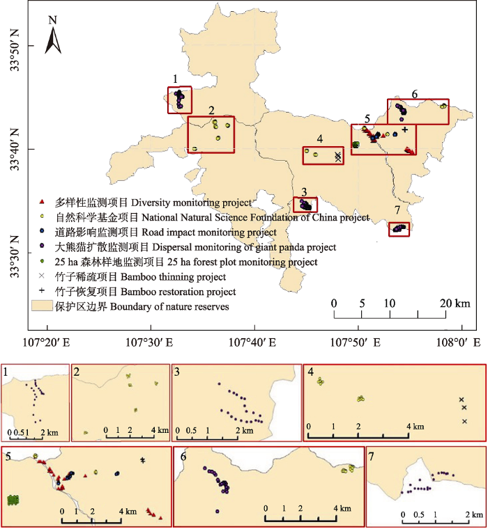
图1
秦岭中段野生动物多样性红外相机监测位点空间分布
Fig.1
Distribution of camera trapping locations for wildlife monitoring in the middle Qinling Mountains
该数据库平台的红外相机没有按照公里网格布设, 而是根据不同时期实施的项目目标布设, 均为单台、常年布设。早期数据是按每隔1-2个月进行一次下载收集, 中后期是按照每3-4个月进行一次下载收集, 后期有长达6个月(头年10月至来年3月)进行收集的, 度过严寒冬季。
3 数据库结构与数据格式
数据库结构还没有形成一个整体, 仍然是以项目为基础, 其数据层级为: 项目-地点-拍摄日期-相机号-照片号。数据库管理构架属于分散式, 是以项目为基础的、非在线的数据系统。数据汇缴方式也是非在线的。
数据细划分到触发对象类别(兽类、鸟类、自然干扰、人为干扰、其他), 还包括照片中动物个体数。根据各个项目的要求, 在数据库中还有环境数据, 如温度、月相, 以及拍摄时间等信息。
4 数据量与拍摄物种名录
至2019年12月, 总相机工作日数152,160 d, 照片总数达855,260张(已处理的692,093张, 待处理的163,167张)。当前仍在野外工作的相机总数110台。
兽类分类参考了《中国哺乳动物多样性(第2版)》(蒋志刚等, 2017)和《中国脊椎动物红色名录》(蒋志刚等, 2016), 鸟类分类参考了《中国鸟类分类与分布名录(第三版)》(郑光美, 2017)。物种列表是以项目为基础的, 即每个项目所有监测的红外相机照片合计。通常, 每个项目的数据库表格字段包括: 相机编号、地点名称、经度、纬度、拍摄日期和具体时间、月相、温度、类型、物种、个体数等。已结束项目的数据库都有相对多度指数(relative abundance index, RAI), 是基于各项目收集的数据计算, 而非所有7个项目总数据计算的RAI。故附录1中物种列表中没有包含RAI信息。
基于已经处理的相机数据鉴定到27种哺乳动物和63种鸟类(附录1)。27种哺乳动物分属于5目14科, 包括劳亚食虫目(猬科1种)、灵长目(猴科1种)、啮齿目(松鼠科4种、豪猪科1种、鼠科1种)、食肉目(大熊猫科1种、熊科1种、鼬科6种、灵猫科1种、猫科3种)和偶蹄目(猪科1种、麝科1种、鹿科2种、牛科3种)。其中, 有国家I级重点保护野生动物5种(大熊猫、川金丝猴、秦岭羚牛、金钱豹Panthera pardus、林麝Moschus berezovskii), II级保护兽类6种(黑熊Ursus thibetanus、中华鬣羚Capricornis milneedwardsii、中华斑羚Naemorhedus griseus、金猫Catopuma temminckii、黄喉貂Martes flavigula、水獭Lutra lutra); 中国特有兽类物种6种(大熊猫、川金丝猴、秦岭羚牛、小麂Muntiacus reevesi、侯氏猬Mesechinus hughi、岩松鼠Sciurotamias davidianus)。
63种鸟类分属于8目24科, 包括鸡形目(雉科4种)、鸽形目(鸠鸽科1种)、鸻形目(鹬科1种)、鹰形目(鹰科3种)、鸮形目(鸱鸮科1种)、犀鸟目(戴胜科1种)、啄木鸟目(啄木鸟科3种)、雀形目(伯劳科1种、鸦科5种、山雀科3种、树莺科1种、柳莺科2种、莺鹛科3种、噪鹛科6种、绣眼鸟科1种、䴓科1种、鸫科7种、鹟科11种、岩鹨科1种、雀科1种、鹡鸰科1种、燕雀科2种、鹀科2种), 其中雀形目的科和种最多。鸟类中没有I级保护物种, 但有8种II级保护物种, 即勺鸡(Pucrasia macrolopha)、红腹角雉(Tragopan temminckii)、血雉(Ithaginis cruentus)、红腹锦鸡(Chrysolophus pictus)、鹰雕(Nisaetus nipalensis)、凤头鹰(Accipiter trivirgatus)、赤腹鹰(A. soloensis)、北领角鸮(Otus semitorques); 有中国特有鸟种(郑光美, 2017) 8种, 包括红腹锦鸡、黄腹山雀(Pardaliparus venustulus)、黄腹树莺(Horornis acanthizoides)、三趾鸦雀(Cholornis paradoxus)、斑背噪鹛(Garrulax lunulatus)、橙翅噪鹛(G. elliotii)、宝兴歌鸫(Turdus mupinensis)、蓝鹀(Emberiza siemsseni)。
5 重要成果
在2012-2019年的7年里, 该数据库平台产出如下重要成果: (1)逐渐完善了秦岭中段区域兽类和鸟类名录(见附录1), 并对典型物种及特别行为进行了报道(刘雪华等, 2015, 2018)。(2)开展了多方面的野生动物行为研究, 包括单物种和类群, 前者如野猪(王长平等, 2015)和黑熊(成果待发表), 后者如有蹄类(贾晓东等, 2014); 研究分析了秦岭野生动物的日活动格局(包括夜行性行为)、季节性活动格局以及年活动格局(武鹏峰等, 2012; 贾晓东, 2015 ( 贾晓东 (2015) 秦岭南坡不同干扰机制下的有蹄类动物多样性研究. 硕士学位论文, 西北大学, 西安.); 赵翔宇, 2018 (② 赵翔宇 (2018) 秦岭不同自然生境下野生动物的生境选择与活动规律研究. 本科学位论文, 清华大学, 北京.); 许心玉, 2019 (③ 许心玉 (2019) 秦岭鸟类分布及活动格局的环境影响因子分析. 本科学位论文, 清华大学, 北京.))。(3)研究了野生动物的生境选择以及在不同森林恢复机制下的生境利用(林瑀璇, 2016 (④ 林瑀璇 (2016) 不同干扰机制下秦岭鸟类多样性及活动特征研究. 本科学位论文, 清华大学, 北京.); 吕子欣, 2016 (⑤ 吕子欣 (2016) 不同干扰机制下的秦岭兽类多样性及活动特征研究. 本科学位论文, 清华大学, 北京.); Liu et al, 2017;Zhang et al, 2019)。(4)对种群数量大的物种进行了种群丰度动态研究(Liu et al, 2013), 提出要关注这些物种种群的数量变化。(5)分析研究了小空间范围内物种与物种之间的关系, 尤其是在同域生境下的关系(Zhang et al, 待发表)。(6)开展了人为干扰对野生动物的影响研究, 如森林砍伐的影响(贾晓东, 2015)、道路建设的影响(成果待发表)。(7)开拓了国际合作, 与美国史密森保护生物学会下的保护生态中心(Conservation Ecology Center, Smithsonian Conservation Biology Institute)合作开展红外相机监测秦岭生物多样性, 与韩国江源国立大学开展在红外相机监测黑熊方面的合作。
6 下一步工作计划及未来建议
目前, 所有以项目为基础的红外相机数据采集均以项目的起始和结束时间为监测时间段。本数据库中仍在进行的两个项目分别是: (1)国家林业与草原局大熊猫国际合作中心项目——秦岭大熊猫扩散的增长-消减区域的非损伤性监测研究, 将在2020年结束; (2)自筹资金项目——秦岭25 ha森林大样地的动物多样性及行为监测研究, 将持续到2023年(5年监测); 并计划将大样地的动物多样性的所有数据上传到中国科学院的生物多样性红外相机数据库网(
我们对未来的数据库建设及相关研究提出如下建议: (1)对于非常偶见的物种, 还需要更长的时间并在更多样化的生境中布设相机, 以获取更多影像数据以评估其濒危现状及行为活动特征, 如: 本数据库中10年内仅出现1次的兽类物种有黄腹鼬、水獭、金猫; (2)数据库需要在更大程度和深度上进行信息挖掘, 尤其在种间关系、物种-生境关系、种群动态等方面; (3)对典型大种群数量的物种(如羚牛和野猪)及食物链顶端大型捕食动物(如金钱豹)进行种群动态研究, 为整个秦岭生态系统的健康持续提供科学支撑; (4)利用数据库的数据及今后红外相机监测数据进行野生动物疾病的发生发展监测研究。
附录 Supplementary Material
附录1 秦岭中段野生动物多样性的红外相机监测数据库平台记录的野生动物物种名录(截至2019年12月)
Appendix 1 Species list of the wildlife camera-trapping database of the middle Qinling Mountains (Before December 2019)
参考文献
Seasonal activity patterns of ungulates in Qinling Mountains based on camera-trap data
DOI:10.3724/SP.J.1003.2014.140073
URL
[本文引用: 1]

Budorcas taxicolor, Naemorhedus griseus, Elaphodus cephalophus, Capricornis milneedwardsii, Muntiacus reevesi and Moschus berezovskii) with 18 infrared cameras. Using the relative abundance index (RAI), we analyzed activity patterns and seasonal differences of these six species. The results show that: (1) their total RAI in the study area reaches 58.71%, the RAI of B. taxicolor was 28.02%, and it was 13.24% for N. griseus, 10.08% for E. cephalophus, 4.21% for C. milneedwardsii, 2.26% for M. reevesi, and 0.90% for M. berezovskii. (2) Monthly RAIs (MRAI) of six ungulates reflected seasonal activity patterns; B. taxicolor, N. griseus, E. cephalophus, C. milneedwardsii, M. reevesi exhibited similar activity patterns. These species were most active in summer, became inactive in autumn and winter, and then gradually increased activity in spring. M. berezovskii, on the other hand, was most active in winter and least active in summer. (3) The time-period relative abundance indices (TRAI) of the six ungulates reflect their daily activity patterns. B. taxicolor and N. griseus have similar daily activity patterns with an active peak at 06:00–20:00.The daily activity pattern of E. cephalophus, M. reevesi and M. berezovskii showed obvious crepuscular habits. C. milneedwardsii also has two peaks but at 02:00–06:00 and 20:00–22:00 implying nocturnal activities. (4) Comparative analyses of daily activity patterns among the four seasons showed that B. taxicolor displayed a different pattern in spring with an activity peak at 16:00–20:00. Compared with other seasons, N. gresius, E. cephalophus and C. milneedwardsii have different patterns in winter with either a delayed or advanced activity peak. In the case of M. reevesi, spring daily activity patterns showed two peaks at 00:00–10:00 and 18:00–20:00. Due to a paucity of captures, M. berezovskii showed different activity patterns in all four seasons. (5) Analysis of the nocturnality showed that C. milneedwardsii was obviously nocturnal with a nighttime relative abundance index (NRAI) of 65.81%. Our results help us to understand the activity patterns of these ungulates in Qinling, to monitor their population dynamics, and provide a theoretical basis and data support for the nature reserves to protect the ungulate animals more efficiently.]]>
利用红外相机分析秦岭有蹄类动物多样性及活动规律
Red List of China’s Vertebrates
DOI:10.17520/biods.2016076 URL [本文引用: 1]
中国脊椎动物红色名录
China’s mammal diversity (2nd edition)
DOI:10.17520/biods.2017098 URL [本文引用: 1]
中国哺乳动物多样性(第2版)
Animal world living in Foping of the southern slope of the Qinling Mountains
生活在佛坪-秦岭南坡的动物世界
Monitoring wildlife abundance and diversity with infra-red camera traps in Guanyinshan Nature Reserve of Shaanxi Province, China
DOI:10.1016/j.ecolind.2012.09.022 URL [本文引用: 1]
Application and data mining of infra-red camera in the monitoring of species
DOI:10.17520/biods.2018053
URL
[本文引用: 1]
Wildlife population is low and most of them are very sensitive to human disturbing, which makes traditional survey difficult. As known, infra-red camera technology has many advantages in wildlife study. However, with its wide application and increased data amount, researchers are facing some problems concerning infra-red camera monitoring and later data processing and analyzing. This paper describes in details three key problems on infra-red camera data management and use, such as lacking standardization, integration and normalization. The present paper also lists and analyzes eight aspects about photo data mining, based on researches carried out in the Qinling Mountains, Wolong Nature Reserve, etc. It involves individual recognition, temporal/spatial activity pattern, information-extracting of occasional species, behavior and reproduction, disease situation and interference by humans. If all this information can be used effectively, we hope to provide scientific support at some extent on wildlife and biodiversity conservation and management in future.
红外相机技术在物种监测中的应用及数据挖掘
Diversity and activity patterns of sympatric animals among four types of forest habitat in Guanyinshan Nature Reserve in the Qinling Mountains, China
DOI:10.1007/s11356-017-9232-x
URL
PMID:28551745
[本文引用: 1]
Research on behavior and abundance of wild boar (Sus scrofa) via infra- red camera in Guanyinshan Nature Reserve in Qinling Mountains, China
应用红外相机技术研究秦岭观音山自然保护区内野猪的行为和丰富度
Giant Panda Habitat Assessment and Sympatric Animal Diversity Analysis in Guanyinshan Nature Reserve, Shaanxi
陕西观音山自然保护区大熊猫栖息地评价及伴生动物多样性分析
The application of infrared camera in mammal research in Guanyinshan Nature Reserve, Shaanxi
红外相机技术在陕西观音山自然保护区兽类监测研究中的应用
Fine-scale activity patterns of large-and-medium mammals in deciduous broadleaf forest
The traditional medicine in Africa in general and specifically in Cameroon does not manage diabetes and arterial hypertension very well. Yet, these pathologies are becoming more prevalent among the populations that need adequate knowledge to fight against them. Therefore the present study was designed to determine the knowledge, attitudes and practices of indigenous people regarding diabetes and hypertension control, and to assess the epidemiological aspects of these diseases in order to reinforce their health education and promote a better health care through traditional medicine. To achieve this objective, 1,131 households including 70 traditional healers, 114 diabetics, 167 hypertensive patients, 30 hypertensive patients-diabetics and other Cameroonians were questioned on their ethnomedical knowledge of diabetes and arterial hypertension. Fifty-eight randomly distributed tribes were taking in account. The elucidation of anthropological and epidemiological aspects of diabetes and hypertension improved the beliefs of indigenous people and facilitated the modernization of diabetes and hypertension comprehension that remained focused on the elucidation of diseases' causes and complications, as well as on the behaviors that could help translate biomedical terms into locally meaningful metaphors.
Animal diversity responding to different forest restoration schemes in the Qinling Mountains, China
