


“野生动物生态廊道(wildlife corridor)”的概念于1974年由Willis首次提出(Willis, 1974)。构建野生动物生态廊道不仅有利于野生动物的迁徙扩散, 提高生境斑块间的连接性, 还能促进濒危物种异质种群间的基因交流、缓解生境破碎化造成的不利影响, 从而降低种群灭绝风险(Crooks & Sanjayan, 2006; Lees & Peres, 2008)。因此在过去十多年里有关野生动物廊道识别、预测和建立的研究工作得到了迅猛发展(Abrahms et al, 2017)。近年来, 国内外学者运用最小成本路径原理(least-cost path theory)和电流理论(circuit theory)开展了一系列具有代表性的濒危物种生态廊道研究工作(Douglas-Hamilton et al, 2005; Dutta et al, 2016; 青菁等, 2016)。虽然有研究证实只有部分野生动物个体利用廊道, 但廊道仍能有效改善生境破碎化的负面效应(Feng et al, 2009)。目前常用的廊道构建方法大多基于模型, 如专家意见模型(Sawyer et al, 2011; 李维平等, 2017)、最小成本路径分析(Adriaensen et al, 2003; 诸葛海锦等, 2015; Hashmi et al, 2017)、电流分析(Pelletier et al, 2014; Pierik et al, 2016)、基于个体的模型(Kanagaraj et al, 2013; Allen et al, 2016)、资源选择函数模型(Boyce & McDonald, 1999; Abrahms et al, 2017)、生态位因子模型(Titeux et al, 2007)等, 但它们在应用方面均存在一定的局限性。最小成本路径模型基于图论测定多种空间运动过程, 反映了异质景观对某种空间运动过程的综合阻力(Knaapen et al, 1992), 被认为是分析异质性景观连接性方面的一种有效的、可操作的、灵活的方法(Adriaensen et al, 2003; Hashmi et al, 2017), 已经成为当前野生动物生态廊道识别的主流方法, 被广泛应用于物种保护、自然保护区规划、区域生态安全格局设计等景观优化工程。
马可波罗盘羊(又称帕米尔盘羊, Ovis polii)(蒋志刚等, 2015)分布于中国、阿富汗、塔吉克斯坦、巴基斯坦和吉尔吉斯斯坦五国边境相邻的帕米尔高原(Valdez et al, 2016), 在中国主要分布于塔什库尔干野生动物自然保护区(以下简称保护区), 是国家Ⅱ级重点保护野生动物, 《中国脊椎动物红色名录》易危级物种(蒋志刚等, 2016)。近年来由于气候变化以及人类活动加剧(过牧、矿业开发、过度狩猎、盗猎等), 马可波罗盘羊生境破碎化严重, 种群数量显著下降(王玉涛等, 2016)。再加上国道314线穿越保护区, 居民定居点及其周围高强度的人类活动势必严重影响该物种的生境连续性。因此开展马可波罗盘羊的生境适应性分析, 有效识别该物种的潜在生态廊道迫在眉睫。
基于上述原因, 本研究在开展马可波罗盘羊生境质量评价的基础上, 运用Linkage Mapper软件(McRae & Kavanagh, 2011), 使用最小成本原理分析识别其核心生境斑块间的潜在生态廊道, 旨在探讨以下问题: (1)马可波罗盘羊的核心生境斑块在保护区是如何分布的? (2)核心生境斑块间是否有潜在迁徙廊道分布? (3)哪些核心生境斑块和生态廊道在维持马可波罗盘羊季节迁徙和基因交流方面非常重要? 以期为相关保护管理部门构建生态廊道、维持马可波罗盘羊生境连通性、实现该物种的有效保护提供科学指导。
1 研究区概况
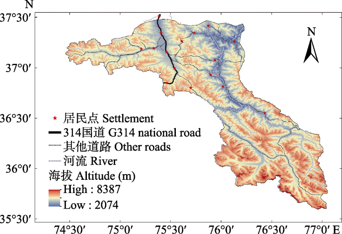
保护区位于中国新疆喀什地区, 西部与巴基斯坦、阿富汗、塔吉克斯坦三国接壤, 地理位置为35°38'-37°30' N, 74°30'-77°00' E (图1), 总面积约15,836 km2, 是我国唯一以马可波罗盘羊为主要保护对象的自然保护区(梁果栋, 1984)。该区域海拔最高8,387 m, 最低2,074 m, 平均海拔4,000 m以上, 地势高差悬殊, 总体从西北向东南倾斜。该地区为典型的大陆性高原干旱荒漠气候, 空气稀薄、日照充足。气候极端寒冷干旱, 年均气温低于0℃, 年均降水量在70 mm左右。研究区内野生动植物资源丰富, 分布有典型的高寒荒漠植物, 常见的植物有紫花针茅(Stipa purpurea)、垫状驼绒藜(Ceratoides compacta)、中麻黄(Ephedra intermedia)、南疆点地梅(Androsace flavescens)、青藏薹草(Carex moorcroftii)等(龚明昊等, 2007)。保护区分布有雪豹(Panthera uncia)、北山羊(Capra sibirica)、胡兀鹫(Gypaetus barbatus)、金雕(Aquila chrysaetos)等10种国家I级重点保护动物, 以及马可波罗盘羊、豺(Cuon alpinus)、藏原羚(Procapra picticaudata)、岩羊(Pseudois nayaur)、藏雪鸡(Tetraogallus tibetanus)、暗腹雪鸡(T. himalayensis)、秃鹫(Aegypius monachus)等25种国家Ⅱ级重点保护动物(王玉涛等, 2016)。国道314线贯穿保护区西北部, 两侧均有围栏、防护林等人工设施, 多数居民点亦沿该国道两侧分布。
图1
2 研究方法
2.1 方法和原理
首先, 采用生境适宜性指数(habitat suitability index, HSI)评估保护区内马可波罗盘羊的生境质量, 确定核心生境。其次, 基于生境质量确定阻力系数, 构建阻力图层。阻力系数表示物种个体穿过某一特定的景观单元的意愿或对景观单元的适宜度(吴昌广等, 2009)。在穿过特定环境的过程中, 如果物种个体能量和时间消耗少, 死亡率低, 意味着该环境阻力低, 则动物从该区域通过的可能性较大(Zeller et al, 2012)。最后, 基于整合电流理论和最小成本路径分析的Linkage Mapper程序(McRae & Kavanagh, 2011)进行廊道识别分析。Linkage Mapper能够识别相邻的核心区域, 利用邻近的核心区域和距离数据创建核心区域网络, 计算成本加权距离和最小成本路径, 最后将成本最低的廊道组合成一张地图。
2.2 数据收集与处理
基于马可波罗盘羊的习性及生境需求, 选取影响其生境适宜性的关键因子, 即海拔、坡度、坡向、植被类型、距水源距离、距道路距离、距居民点距离。数据来源如下: (1)研究区域30 m × 30 m的海拔数据来源于中国科学院计算机网络信息中心地理空间数据云平台(http://www.gscloud.cn); 坡度、坡向数据由本区域的数字高程经ArcGIS空间分析处理得到; (2)植被类型矢量数据, 截取于1:100万植被图; (3)道路、居民点、水系分布数据以及国界线矢量数据均来源于2017版全国基础地理数据库; (4)保护区边界与范围数据由保护区提供。
在开展马可波罗盘羊野外调查之前, 咨询当地牧民和保护区工作人员, 初步确定其分布区域, 参照保护区的地形地貌沿主要沟谷布设16条样线(陈强强等, 2018)。2016-2017年沿样线驾车或徒步行进, 用8 × 42双筒望远镜和20-60倍单筒望远镜观测, 发现马可波罗盘羊后记录观测点的经纬度坐标、马可波罗盘羊与观测点间的角度、距离。根据观测点经纬度、距离以及夹角计算出马可波罗盘羊实际分布位点的经纬度信息(宓春荣等, 2017)。统计盘羊实际分布数据, 确定该物种对不同植被类型、地形因子等的偏好性。
结合野外调查报告以及相关文献和专家建议将不同的植被类型、海拔、坡度、坡向、坡位及距水源距离按照马可波罗盘羊对其的适宜性分别赋予不同的值。距居民点、道路的不同距离能够反映人类活动对马可波罗盘羊的不同影响程度, 因此本研究针对道路和居民点建立不同等级的缓冲区, 并为每个缓冲区赋值, 最终转化为栅格图层。相关方法详见田波等(2008)和诸葛海锦等(2014)。前人研究表明, 马可波罗盘羊喜好植被密度较低的碎石地, 该类型生境中分布的主要物种为禾本科和莎草科植物, 此外也有小丛红景天(Rhodiola rosea)和驼绒藜(Ceratoides latens); 马可波罗盘羊分布区域均远离公路和居民点(余玉群等, 2008; 王玉涛等, 2016; Salas et al, 2017)。
2.3 潜在生态廊道识别
2.3.1 核心生境斑块(源)的划定
利用生境适宜性指数表征马可波罗盘羊的生境需求与其分布环境之间的关系(诸葛海锦等, 2014)。计算公式如下:
式中, Fi代表每个因子对马可波罗盘羊的适宜性取值(表1), 适宜性得分依据野外采集的马可波罗盘羊分布点数据(164个位点), 以及前人的研究结果, 并结合专家打分法确定。Fi介于0-100%, 其值越高表示生境适宜性越高。n表示生境因子个数, 此处n = 6。为避免因子之间可能高度自相关而干扰模型分析结果, 本文运用ArcGIS中的“波段集统计”空间分析工具, 对6种生境因子进行了相关性分析, 结果表明各因子间相关系数均小于0.5, 不存在相关性。
表1 影响马可波罗盘羊的生境因子取值(Fi)
Table 1
| 生境因子 Habitat factors | 范围 Range | Fi (%) | 生境因子 Habitat factors | 范围 Range | Fi (%) | |
|---|---|---|---|---|---|---|
| 夏季 Summer | 冬季 Winter | |||||
| 海拔 Elevation (m) | ≤ 3,500 | 2 | 0 | 距国道314线距离 Distance to G314 national road (m) | ≤ 1,000 | 0 |
| 3,501-4,000 | 65 | 65 | 1,001-2,000 | 25 | ||
| 4,001-4,500 | 100 | 100 | 2,001-3,000 | 50 | ||
| 4,501-5,000 | 10 | 14 | 3,001-4,000 | 75 | ||
| ≥ 5,001 | 5 | 0 | ≥ 4,001 | 100 | ||
| 坡度 Slope (°) | ≤ 10 | 35 | 100 | 距乡道距离 Distance to village road (m) | ≤ 400 | 0 |
| 11-20 | 100 | 83 | 401-600 | 25 | ||
| 21-30 | 40 | 44 | 601-800 | 50 | ||
| ≥ 31 | 30 | 35 | 801-1,000 | 75 | ||
| 坡位 Slope position | 上 Top | 60 | 69 | ≥ 1,001 | 100 | |
| 中 Middle | 100 | 100 | 距居民点距离 Distance to settlement (m) | ≤ 400 | 0 | |
| 下 Bottom | 40 | 63 | 401-800 | 25 | ||
| 坡向 Slope aspect | 东 East | 100 | 73 | 801-1,200 | 50 | |
| 南 South | 60 | 100 | 1,201-1,600 | 75 | ||
| 西 West | 35 | 16 | ≥ 1,601 | 100 | ||
| 北 North | 65 | 50 | 距牧场距离 Distance to pastures (m) | ≤ 750 | 0 | |
| 植被类型 Vegetation type | 垫状驼绒藜高寒荒漠a | 5 | 0 | 751-1,500 | 25 | |
| 风毛菊、红景天稀疏植被b | 10 | 0 | 1,501-2,250 | 50 | ||
| 羊茅高寒草原c | 20 | 22 | 2,251-3,000 | 75 | ||
| 短花针茅荒漠草原d | 25 | 30 | ≥ 3,001 | 100 | ||
| 麻黄荒漠e | 30 | 17 | ||||
| 驼绒藜荒漠f | 45 | 17 | ||||
| 高山绢蒿、高山紫菀高寒荒漠g | 100 | 100 | ||||
| 距水源距离 Distance to water (m) | ≤ 1,000 | 100 | 100 | |||
| 1,001-2,000 | 65 | 48 | ||||
| ≥ 2,001 | 55 | 63 | ||||
a, Ceratoides compacta alpine desert; b, Saussurea spp.+ Rhodiola spp. sparse vegetation; c, Festuca spp. alpine grassland; d, Stipa breviflora desert steppe; e, Ephedra spp. desert; f, Ceratoides latens desert; g, Seriphidium rhodanthum + Aster alpinus alpine desert.
仅考虑自然因素的理想条件下, 获得的是野生动物的潜在生境, 但潜在生境往往受多种因素干扰而无法被野生动物有效利用, 因此不能客观反映出野生动物的实际生境状况。基于此, 本文选用距国道314线距离、距乡道距离、距居民点距离以及距牧场距离为主要人为干扰因子(表1), 修正马可波罗盘羊的潜在生境而获得实际生境。
采用ArcGIS中自带的Natural Breaks方法将所得的HSI划分为不适宜生境、一般生境、较适宜生境、最适宜生境4个等级。HSI模型建立后, 利用2018年从野外调查的马可波罗盘羊位点、粪便等夏冬两季分布点数据(81、50)验证适宜性分析结果的准确度(王志强等, 2009; 刘慧明等, 2016)。参照前人在塔吉克斯坦对马可波罗盘羊的研究以及专家意见, 夏季约10 km2的最适宜生境面积能够维持大约20只马可波罗盘羊个体; 冬季20只个体的集群至少需要约5 km2的面积(Yeganeh et al, 2016)。本文将夏季最适宜生境中面积 > 10 km2的生境斑块作为核心生境斑块(core patches, CPs); 将冬季最适宜生境中面积 > 5 km2的斑块作为核心生境斑块。2.3.2 阻力栅格构建根据生境适宜性指数的结果设置阻力值(李维平等, 2017), 设定最高阻力为100, 最低为1。此外依据马可波罗盘羊对生境的实际需求, 参考前人的研究结果, 以及人类活动干扰强度(王玉涛等, 2016; Salas et al, 2017), 在ArcGIS中将各因子统一设定4个适宜性级别并分别赋阻力值: 最适宜生境(1)、较适宜生境(30)、一般生境(60)和不适宜生境(100)。阻力图层的每一个值反映的是当物种经过该栅格时遇到的阻碍, 阻力值越大, 说明阻碍越强, 迁移成本越高。2.3.3 廊道质量及其与核心生境斑块的重要性分析将上述所得马可波罗盘羊核心生境斑块和计算所得的阻力图层共同导入Linkage Mapper廊道模拟软件, 识别并分析马可波罗盘羊的潜在廊道。运用两种不同的度量方法描述每条廊道的质量(Dutta et al, 2016)。第一种是基于每一对相邻核心生境斑块间廊道的成本加权距离与欧几里得距离(Euclidean Distance, EucD)的比值(CWD : EucD)。比值越大, 意味着该廊道的阻力也越大。对于具有最高质量的廊道其成本加权距离等于欧几里得距离, 因此比值为1。这一比值表示相对于相邻核心生境斑块间的距离, 盘羊在两者之间移动的困难程度。第二种是利用成本加权距离与最小成本路径的比值(CWD : LCP), 该比值反映出个体在一对相邻的核心生境斑块之间迁移时, 在所选择的最佳路径上遇到的平均阻力。廊道绘制完成后, 运行Centrality Mapper (McRae, 2012)模块调用电路理论程序Circuitscape (McRae & Shah, 2009)估算每个生境斑块与廊道的中心性值。中心性值表示每个核心生境斑块和走廊在维护整个生境斑块网络连通性的重要性, 值越高, 重要性越高(Carroll et al, 2012)。
3 结果
3.1 马可波罗盘羊适宜生境与核心生境斑块
图2
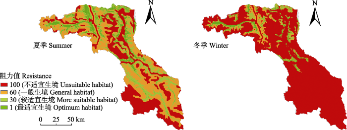
图2
马可波罗盘羊栖息地阻力(适宜性等级)栅格图
Fig. 2
Grid in resistance (habitat suitability) of Marco Polo sheep’ habitat
保护区西北部是马可波罗盘羊核心生境斑块分布最集中且面积相对较大的区域。夏冬两季马可波罗盘羊核心生境斑块较少, 均为28 (图3), 总面积分别为1,075.42 km2和454.66 km2, 占整个保护区面积的6.78%和2.87%。适宜性分析的准确度验证结果表明, 夏冬两季分别有93.62%、76%的盘羊分布点落在适宜生境内, 表明生境适宜性评价结果比较准确。
图3
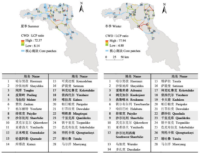
图3
马可波罗盘羊核心生境斑块及成本加权距离(CWD)与最小成本路径(LCP)之比所示的廊道质量。红色表示沿着最小成本路径移动的成本较高, 绿色表示在最小成本路径上连接的质量更高。图中数字代表核心生境斑块。
Fig. 3
Core habitat areas of Marco Polo sheep and the quality of linkages shown by the ratio of cost-weighted distance (CWD) to least-cost path (LCP). Red lines indicate higher cost of movement along the path of least resistance and green lines indicate higher quality along the least-cost path. The numbers in the figure represent core patches.
3.2 核心生境斑块间的潜在生态廊道质量
图4
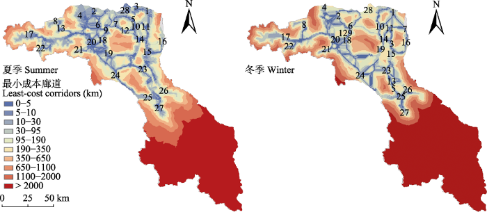
图4
马可波罗盘羊的最小成本廊道分布图。蓝色区域表示阻力较低的路径, 红色区域表示成本加权距离非常大。数字含义同
Fig. 4
Maps showing least-cost corridors for the Marco polo sheep in the study area. Lower resistance paths are shown in blue, and red areas represent higher cost-weighted distance.
夏季45条廊道的欧几里得距离平均值为20.87 ± 10.40 km (5.93-53.19 km), 加权成本距离平均值为299.72 ± 23.67 km (9.60-1,056.31 km), 最小成本路径平均值为9.28 ± 6.44 km (0.90-30.62 km)(表2)。夏季廊道中, 欧几里得距离、最小成本路径及加权平均距离最小的3条廊道是5-10、6-9和3-28斑块间, 最大的是14-24和17-20斑块间。冬季47条廊道的欧几里得距离平均值为20.72 ± 11.26 km (4.22-48.11 km), 加权成本距离平均值为726.63 ± 599.11 km (28.32-2,136.49 km), 最小成本路径平均值为14.92 ± 10.49 km (2.22-41.54 km)(表3)。冬季欧几里得距离、最小成本路径及加权平均距离最小的3条廊道是12-18、6-9和9-12斑块间, 最大的是17-20、19-25、20-19和20-24斑块间。
表2 夏季28个核心生境斑块(CPs)之间45条廊道的特征
Table 2
| 廊道Corridor | 欧几里 得距离 EucD (km) | 加权成 本距离 CWD (km) | 最小成 本路径 LCP (km) | CWD : EucD | CWD : LCP | 中心 性值 CFC (Amps) | 廊道Corridor | 欧几里 得距离 EucD (km) | 加权成本距离 CWD (km) | 最小成本路径 LCP (km) | CWD : EucD | CWD : LCP | 中心 性值CFC (Amps) |
|---|---|---|---|---|---|---|---|---|---|---|---|---|---|
| 3-28 | 13.68 | 9.60 | 0.90 | 0.70 | 10.67 | 75.06 | 19-20 | 33.96 | 378.30 | 6.30 | 11.14 | 60.05 | 35.23 |
| 5-10 | 5.93 | 59.95 | 2.35 | 10.12 | 25.53 | 69.68 | 9-28 | 21.94 | 345.53 | 10.56 | 15.75 | 32.71 | 34.34 |
| 4-20 | 25.24 | 65.65 | 2.95 | 2.60 | 22.27 | 68.02 | 7-28 | 12.60 | 197.59 | 6.77 | 15.68 | 29.20 | 33.65 |
| 5-28 | 14.41 | 151.92 | 5.55 | 10.55 | 27.40 | 67.89 | 20-24 | 53.19 | 1,024.50 | 28.79 | 19.26 | 35.59 | 32.74 |
| 25-26 | 19.42 | 150.66 | 3.62 | 7.76 | 41.61 | 66.95 | 14-23 | 24.48 | 457.02 | 23.16 | 18.67 | 19.74 | 32.55 |
| 24-25 | 34.96 | 239.04 | 15.21 | 6.84 | 15.72 | 62.88 | 18-20 | 27.22 | 389.17 | 6.59 | 14.30 | 59.05 | 32.32 |
| 11-15 | 26.88 | 118.06 | 4.35 | 4.39 | 27.17 | 59.10 | 6-20 | 27.56 | 424.47 | 10.39 | 15.40 | 40.86 | 32.26 |
| 10-14 | 19.88 | 109.08 | 7.37 | 5.49 | 14.81 | 56.77 | 12-14 | 20.13 | 391.45 | 13.74 | 19.45 | 28.49 | 31.20 |
| 1-3 | 13.30 | 39.67 | 4.87 | 2.98 | 8.14 | 56.26 | 15-23 | 17.21 | 380.47 | 5.32 | 22.10 | 71.54 | 29.35 |
| 18-19 | 12.59 | 71.92 | 4.87 | 5.71 | 14.76 | 53.08 | 10-11 | 9.67 | 402.79 | 5.57 | 41.64 | 72.37 | 28.81 |
| 13-20 | 16.96 | 222.02 | 10.49 | 13.09 | 21.16 | 52.00 | 4-6 | 18.49 | 407.77 | 9.67 | 22.05 | 42.16 | 27.89 |
| 7-12 | 9.33 | 128.15 | 5.37 | 13.74 | 23.87 | 51.24 | 8-13 | 8.31 | 113.96 | 6.39 | 13.72 | 17.82 | 27.00 |
| 6-9 | 8.20 | 66.22 | 3.37 | 8.08 | 19.64 | 49.61 | 15-16 | 20.48 | 187.68 | 12.66 | 9.16 | 14.82 | 27.00 |
| 9-18 | 11.71 | 126.48 | 5.19 | 10.81 | 24.35 | 46.89 | 17-20 | 44.94 | 79.65 | 4.65 | 1.77 | 17.15 | 27.00 |
| 2-28 | 26.20 | 301.39 | 10.17 | 11.50 | 29.64 | 44.66 | 20-21 | 11.31 | 125.54 | 5.67 | 11.10 | 22.14 | 27.00 |
| 23-26 | 30.33 | 214.05 | 8.39 | 7.06 | 25.51 | 43.61 | 20-22 | 33.10 | 174.76 | 5.85 | 5.28 | 29.90 | 27.00 |
| 7-9 | 10.44 | 304.11 | 7.47 | 29.14 | 40.72 | 42.75 | 25-27 | 19.13 | 240.98 | 4.57 | 12.60 | 52.71 | 27.00 |
| 14-15 | 13.17 | 282.16 | 4.05 | 21.42 | 69.76 | 40.14 | 14-19 | 29.39 | 895.98 | 13.97 | 30.49 | 64.15 | 26.42 |
| 1-11 | 14.26 | 507.33 | 9.32 | 35.58 | 54.43 | 38.09 | 2-6 | 14.56 | 172.00 | 9.06 | 11.81 | 18.98 | 26.31 |
| 6-28 | 25.55 | 347.54 | 13.21 | 13.60 | 26.30 | 38.01 | 6-18 | 14.43 | 187.94 | 11.52 | 13.03 | 16.32 | 26.30 |
| 19-24 | 24.20 | 663.07 | 22.25 | 27.39 | 29.81 | 36.52 | 10-12 | 13.10 | 451.88 | 14.46 | 34.50 | 31.24 | 21.91 |
| 15-26 | 40.58 | 457.27 | 13.74 | 11.27 | 33.28 | 35.96 | 14-24 | 35.42 | 1,056.31 | 30.62 | 29.82 | 34.49 | 19.06 |
| 2-4 | 11.42 | 366.32 | 6.24 | 32.07 | 58.71 | 35.74 | 平均 Average | 20.54 | 282.52 | 8.79 | 14.79 | 32.78 | 41.00 |
The names of location represented by numbers in the column of corridors are the same as
廊道一列中数字代表的地名同
从加权平均距离与欧几里得距离的比值(CWD : EucD)来分析, 夏季45条廊道的平均值为15.12 ± 9.72。比值最低的廊道是3-28、17-20、4-20和1-3斑块间, 表明这4条廊道质量较高, 盘羊在其中迁移的成本较低; 而比值较高的廊道是10-11、1-11、10-12斑块间, 这3条廊道质量较低, 盘羊在其中迁移的成本较高(表2)。冬季47条廊道的平均值为32.87 ± 18.20。其中比值较低的廊道是17-20、3-15和17-22斑块间, 廊道质量较高; 比值较高的廊道是23-24和19-24, 表明盘羊在其中迁移的成本较高(表3)。夏季廊道中, 7-28 (EucD = 12.60)和18-19 (EucD = 12.59)的欧几里得距离几乎相等, 但是在7-28中迁移消耗的成本(CWD : EucD = 15.68)要比18-19 (5.71)大很多(表2)。
从加权成本距离与最小成本路径的比值(CWD : LCP)来分析, 夏季45条廊道的平均值为32.82 ± 17.07。其中比值较低的廊道是1-3和3-28, 表明这2条廊道质量较高, 盘羊在其中迁移的成本较低。比值较高的廊道是10-11、15-23和14-15, 表明盘羊在其中迁移的成本较高。以夏季廊道10-14和7-9为例, 二者最小成本路径基本相同(分别为7.37 km和7.47 km), 盘羊沿最低成本路径移动时, 在10-14所遇到的平均阻力要比7-9小很多(CWD : LCP比值分别为14.81和40.72, 表2)。冬季47条廊道的CWD : LCP平均值为45.45 ± 20.66, 比值较低的廊道是3-15和12-18, 表示这2条廊道质量较高。而比值较高的2条廊道是23-24和19-24, 表明盘羊在其中迁移的成本较高(表3, 图4)。
表3 冬季28个核心生境斑块(CPs)之间47条廊道的特征
Table 3
| 廊道 Corridor | 欧几里 得距离 EucD (km) | 加权成 本距离 CWD (km) | 最小成 本距离LCP (km) | CWD : EucD | CWD : LCP | 中心 性值CFC (Amps) | 廊道 Corridor | 欧几里 得距离EucD (km) | 加权成 本距离 CWD (km) | 最小成 本距离LCP (km) | CWD : EucD | CWD : LCP | 中心 性值CFC (Amps) |
|---|---|---|---|---|---|---|---|---|---|---|---|---|---|
| 3-15 | 13.49 | 30.95 | 6.34 | 2.29 | 4.88 | 91.46 | 25-26 | 20.05 | 412.09 | 6.17 | 20.55 | 66.83 | 36.05 |
| 9-12 | 5.48 | 88.06 | 4.05 | 16.08 | 21.77 | 80.38 | 18-24 | 36.71 | 1,636.84 | 41.54 | 44.59 | 39.40 | 34.71 |
| 6-9 | 5.48 | 28.32 | 2.22 | 5.17 | 12.74 | 79.90 | 23-13 | 12.86 | 803.84 | 11.82 | 62.49 | 68.04 | 34.00 |
| 17-20 | 48.11 | 45.08 | 3.07 | 0.94 | 14.67 | 75.00 | 4-20 | 30.13 | 593.00 | 18.69 | 19.68 | 31.74 | 33.77 |
| 1-28 | 24.28 | 195.34 | 13.51 | 8.04 | 14.46 | 73.43 | 20-19 | 43.16 | 2,051.04 | 38.53 | 47.53 | 53.24 | 31.33 |
| 14-19 | 14.25 | 183.03 | 7.37 | 12.84 | 24.85 | 71.63 | 18-19 | 31.93 | 1,837.59 | 37.42 | 57.54 | 49.10 | 30.64 |
| 12-18 | 4.22 | 45.40 | 5.19 | 10.76 | 8.74 | 65.19 | 1-7 | 21.97 | 1,361.46 | 19.17 | 61.96 | 71.01 | 30.56 |
| 6-28 | 21.66 | 619.93 | 12.31 | 28.62 | 50.35 | 63.12 | 11-10 | 9.71 | 518.61 | 7.32 | 53.43 | 70.90 | 27.77 |
| 15-23 | 13.68 | 480.66 | 6.64 | 35.14 | 72.37 | 61.96 | 8-17 | 20.23 | 499.82 | 6.85 | 24.71 | 72.99 | 27.00 |
| 14-3 | 8.23 | 355.53 | 6.02 | 43.20 | 59.05 | 59.63 | 17-22 | 10.07 | 41.90 | 3.50 | 4.16 | 11.98 | 27.00 |
| 5-25 | 6.81 | 111.03 | 2.42 | 16.31 | 45.86 | 53.14 | 20-21 | 12.28 | 97.28 | 4.57 | 7.92 | 21.28 | 27.00 |
| 13-5 | 6.66 | 154.23 | 5.72 | 23.14 | 26.96 | 47.54 | 25-27 | 17.96 | 377.52 | 8.07 | 21.03 | 46.79 | 27.00 |
| 24-25 | 35.90 | 1,235.26 | 17.20 | 34.41 | 71.83 | 46.03 | 19-25 | 43.78 | 2,136.49 | 35.55 | 48.80 | 60.10 | 26.56 |
| 2-28 | 28.36 | 858.78 | 16.54 | 30.29 | 51.91 | 45.31 | 2-4 | 13.89 | 570.71 | 11.37 | 41.08 | 50.20 | 26.53 |
| 10-28 | 18.74 | 711.69 | 12.36 | 37.98 | 57.57 | 44.83 | 2-6 | 16.72 | 557.02 | 17.43 | 33.31 | 31.95 | 24.45 |
| 7-16 | 11.57 | 179.77 | 12.06 | 15.54 | 14.90 | 44.40 | 2-20 | 25.92 | 1,015.82 | 25.60 | 39.18 | 39.69 | 23.94 |
| 16-15 | 21.83 | 686.87 | 19.66 | 31.47 | 34.94 | 43.52 | 11-7 | 15.35 | 914.29 | 13.97 | 59.57 | 65.47 | 23.56 |
| 11-3 | 16.52 | 529.36 | 15.44 | 32.04 | 34.29 | 43.31 | 13-26 | 20.94 | 503.17 | 7.05 | 24.02 | 71.42 | 22.93 |
| 10-14 | 13.56 | 379.56 | 13.02 | 28.00 | 29.16 | 41.61 | 23-24 | 26.53 | 2,109.18 | 27.06 | 79.51 | 77.94 | 22.45 |
| 1-11 | 15.50 | 700.52 | 12.51 | 45.20 | 56.00 | 40.67 | 23-26 | 31.65 | 987.18 | 19.18 | 31.19 | 51.46 | 22.23 |
| 20-12 | 12.83 | 508.98 | 11.14 | 39.68 | 45.68 | 38.35 | 11-14 | 14.05 | 740.74 | 11.41 | 52.71 | 64.91 | 20.86 |
| 20-18 | 11.71 | 507.04 | 7.99 | 43.30 | 63.47 | 37.17 | 4-6 | 29.28 | 955.24 | 30.68 | 32.62 | 31.14 | 18.96 |
| 15-26 | 39.21 | 1,204.82 | 23.79 | 30.73 | 50.65 | 36.48 | 19-24 | 28.16 | 1,815.86 | 24.56 | 64.49 | 73.92 | 17.89 |
| 20-24 | 42.64 | 1,774.72 | 37.30 | 41.62 | 47.58 | 36.14 | 平均 Average | 20.72 | 726.63 | 14.92 | 32.87 | 45.45 | 41.22 |
The names of location represented by numbers in the column of corridors are the same as
廊道一列中数字代表的地名同
3.3 核心生境斑块与廊道的中心性值
图5
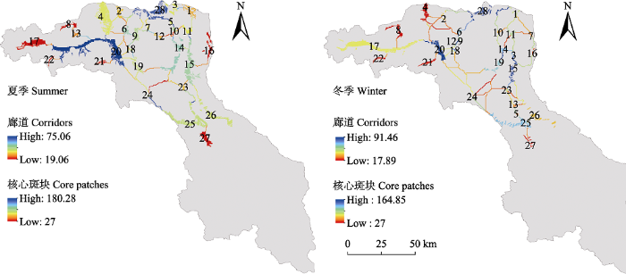
图5
研究区域核心生境斑块(CPs)和各廊道中心性值(色块显示的数值)
Fig. 5
Current centrality for core patches (CPs) and corridors in the study area
4 讨论
4.1 核心生境的地理分布特征
本文的研究结果表明, 夏、冬两季马可波罗盘羊适宜生境主要集中分布于保护区西北部及中部较小的区域范围内, 且核心生境斑块较分散, 破碎化较严重, 在保护区东部几乎没有适宜生境分布(图2)。Salas等(2017)研究发现马可波罗盘羊偏好坡度较缓的开阔峡谷, 而保护区的西北部和中部为开阔的峡谷和相对平缓的台地(图4)。冬季马可波罗盘羊的适宜生境面积明显低于夏季, 主要原因如下: (1)保护区冬季植被覆盖度明显低于夏季, 植物枯萎, 加之积雪遮盖, 地上可利用生物量远远低于夏季; (2)保护区冬季气候条件恶劣, 气温极低, 尤其是保护区南部地形起伏, 山峰陡峭, 沟谷纵横, 气候条件更加恶劣。而马可波罗盘羊对低温较敏感, 所以在冬季保护区东部大部分地区不适合其生存。Khan等(2016)亦证实分布于中国和巴基斯坦交界处的马可波罗盘羊在冬季主要选择植被覆盖度较高的区域来躲避低温。
Schaller等(1987)曾于1959年在红其拉甫地区记录过65只雄性马可波罗盘羊, 但是我们在近几年野外调查中并未在此处发现马可波罗盘羊, 龚明昊等(2007)也仅发现了盘羊的头骨。以此判断, 马可波罗盘羊在保护区内的分布范围有向北退缩的趋势。保护区位于帕米尔高原东缘, 是马可波罗盘羊世界分布区的最东南边缘地带。如果保护区生境持续恶化, 人为干扰持续增加, 最终可能导致马可波罗盘羊在中国境内消失。综上所述, 保护区西北部是马可波罗盘羊的重点保护区域, 应及时在该区域维持和建立斑块之间的连通廊道, 以确保盘羊种群间的基因交流, 维持种群繁衍生存。
4.2 核心生境斑块与廊道的中心性值
夏季核心生境斑块20和28, 以及冬季核心生境斑块20、15、28的中心性值最高, 因此应确保这些斑块的连续性和完整性, 加强与周围其他景观类型的连接, 以扩大斑块面积, 提高斑块质量, 促进马可波罗盘羊的迁移和交流。夏季4-20、3-28和5-10, 以及冬季3-15、9-12和6-9这6条廊道的中心性值较高, 这些廊道对于维持整个廊道网络的连通性最为重要。此外, 这些廊道的最小成本距离相对较短, 极有可能是盘羊的迁移廊道。虽然上述廊道中心性值很高, 但就保护区整体而言, 夏冬两季核心生境斑块基本重叠, 且大多数廊道沿沟谷分布, 因此在没有人为干扰和大型水体阻隔的情况下, 廊道质量主要与其最小成本路径上的欧几里得距离远近相关。此外, 根据CWD : EucD、CWD : LCP以及廊道的中心性三个值得出, 冬夏季共同的最优廊道是17-20, 该廊道欧几里得距离短, 且连接着两个主要的核心生境斑块, 因此在未来的保护工作中应重点关注这些廊道和斑块。
马可波罗盘羊主要分布在中国与吉尔吉斯斯坦、塔吉克斯坦、阿富汗和巴基斯坦等四国的边境地带(Schaller & Kang, 2008; Salas et al, 2017), 有季节性迁徙的习性(Valdez et al, 2016)。保护区内马可波罗盘羊种群的繁衍与发展主要依靠跨境基因交流而维持。阿富汗境内的马可波罗盘羊主要集中于瓦罕走廊(Smallwood et al, 2011), 已有研究表明在保护区内中国瓦罕走廊区域的皮斯岭、卡拉奇古等地存在马可波罗盘羊的跨境迁移廊道(Schaller & Kang, 2008)。因此, 需要强调的是, 虽然本研究中所识别的位于保护区边缘的生境斑块和廊道中心性值较低, 但并不意味着其重要性不足。原因如下: (1)夏季斑块8、17、21、22及冬季斑块8、22、21分别位于中国与阿富汗和塔吉克斯坦边境沿线一带, 在维持马可波罗盘羊种群跨境基因交流方面起着重要的桥梁作用。(2)虽然北部的1、2、4等斑块中心性值也不高, 但它们是连接保护区内外种群基因交流的桥梁。(3)虽然夏季斑块6、9、18、11和冬季斑块10、9的面积较小, 中心性值较低, 但地理位置重要, 起到保证整个廊道网络中几个重要斑块连通的踏脚石作用。如果没有这些小面积斑块, 则廊道会因斑块之间距离太远受到干扰被中断, 因此这些斑块的重要性也不容忽视。
4.3 廊道的有效性和廊道宽度
本研究表明夏季核心生境斑块4与6, 19与20之间存在多条廊道连接, 另外大多相邻斑块对之间都有可替代的廊道(图4)。Dutta等(2016)认为当有更多的廊道可供选择时, 物种在景观中移动时有可选择的替代路径, 可提高种群之间的连接性。本研究结果表明保护区马可波罗盘羊生境斑块间的连通性相对较好, 但有待进一步评估上述廊道的功能状况和可利用性。建议当地政府在实验区建设检查站点, 以及在边境区域建设公安边防检查哨所时, 尽量回避廊道所在区域和邻近区域。遗憾的是, 本文仅展现了马可波罗盘羊的线性廊道, 并未进一步计算廊道的具体宽度, 今后在研究工作中设计生态廊道时, 要充分考虑多方面因素, 合理设计廊道宽度, 以避免廊道过窄产生的边缘效应, 或廊道过宽导致物种在生态廊道中移动缓慢。
4.4 国道对生态廊道有效性的影响
当核心生境斑块间的欧几里得距离较大或廊道穿过河谷或交通道路时, 连接质量最低(Dutta et al, 2016)。本研究中与国道314线相交的廊道质量均很低(图4), 主要是因为道路的存在显著增大了盘羊在斑块间迁移的阻力(Tischendorf & Fahring, 2000), 使迁移难度大大增加, 不利于种群交流和扩散。当生态廊道与交通线交叉时, 交叉区域会形成生态断裂点, 生物难以跨越, 因车辆撞击导致的动物死亡数量和概率也很高(池源等, 2015)。Schaller等(1987)也曾指出随着喀喇昆仑公路的建成, 马可波罗盘羊在保护区边界的巴基斯坦境内数量持续降低。诸多研究表明, 道路对野生动物迁移具有明显的阻隔作用, 且道路等级越高, 阻隔作用越大(李帅等, 2018)。因此需要重视生态断裂点的修复, 加快建设下穿式和上跨式通道, 恢复和维持较高的景观连通性, 促进生境斑块间物质、能量和信息的正常流通。保护区夏季斑块20与24, 17与20, 15与26之间的廊道, 冬季斑块17与20, 19与25之间的廊道虽然没有人为干扰, 但廊道欧几里得距离较大, 因此很容易受到其他因素的影响而导致连接中断。保护区的盘羊主要集中在西北部, 在今后廊道建设中应优先考虑西北部各斑块之间的连通性, 尤其是国道314线两侧, 其次考虑东南侧的潜在廊道区。国道314线达布达尔、麻扎向南至红其拉甫边防哨所路段, 历史上记录有盘羊分布迁移跨越, 因此可考虑在G314线横切廊道处建设上跨式或者下穿式野生动物通道(图6), 将两侧的马可波罗盘羊生境斑块连接起来。
图6
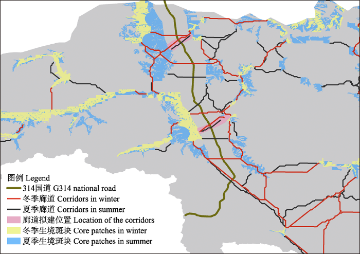
图6
塔什库尔干野生动物自然保护区内国道314线两侧拟建廊道位置
Fig. 6
Proposed corridor location on both sides of G314 in Taxkorgan Wildlife Nature Reserve
4.5 本研究的理论预测、实用性分析与局限性
本研究基于最小成本距离原理与电流理论的Linkage Mapper模型模拟识别了马可波罗盘羊的潜在生态廊道。与其他任何模型一样, 本研究由于建模者的某些主观选择而存在局限性。虽然在研究区存在很多潜在廊道, 但并非本文所确定的所有廊道都适合马可波罗盘羊迁移。由于没有指定任何最大的廊道长度或成本, 我们的连接分析只确定了一个最好的连接选择, 并没有进一步考虑盘羊能否在识别的廊道中迁移。因此这里建议: (1)未来通过给盘羊佩戴无线电跟踪项圈, 精准筛选盘羊的迁移廊道;
(2)基于分子生物学手段测定各种群基因流, 以此判断盘羊在各斑块间的迁移规律; (3)有必要赴实地验证上述廊道是否有马可波罗盘羊存在和迁移。我们所分析的景观要素均基于马可波罗盘羊的生境偏好, 然而马可波罗盘羊很可能越过本研究区至保护区外活动, 因此部分结果的准确性(例如中心性值)可能会受到人为确定边界的影响。例如有些核心生境斑块可能在更大尺度区域中非常重要, 但是在本研究中因为处于保护区边缘而被判定为不重要的斑块。研究区地形复杂, 受数据分辨率的影响, 某些影响廊道分布的微地形、小尺度的水系分布等因素可能被忽略, 这些因素都会在一定程度上影响廊道模拟的结果。此外, 由于保护区内马可波罗盘羊种群的健康发展不仅依赖于对保护区的有效管理与保护, 亦更依赖于可持续稳定迁入/迁出保护区的外部种群。因此为确保保护区内马可波罗盘羊种群的持续健康发展, 今后研究工作中应更加注重大尺度上马可波罗盘羊生态廊道的识别与分析, 例如保护区内与保护区外马可波罗盘羊的廊道识别, 中国种群与阿富汗、巴基斯坦和塔吉克斯坦种群的跨境廊道识别。另外, 保护区内与马可波罗盘羊同域分布的野生动物还有雪豹、北山羊等, 维护马可波罗盘羊迁移廊道对保护上述物种也至关重要。
致谢: 感谢塔什库尔干保护区管理局米鲁、依明江、尕娃尔夏和周莉主任在野外调查中的大力支持和帮助, 感谢喀什大学王玉涛教授对野外调查的指导与帮助。
参考文献
Relating populations to habitats using resource selection functions
DOI:10.1016/S0169-5347(99)01593-1
URL
PMID:10370262
[本文引用: 1]

Habitat use can be characterized by resource selection functions (RSFs) that are proportional to the probability of an area being used by an animal. We highlight two procedures that have recently been used to relate RSFs to population density, dependent upon which field procedures are practical for a species. These new developments allow RSF models to be interfaced with geographical information systems (GIS) to map the probability of use, and ultimately populations, across landscapes.
Use of Linkage Mapping and Centrality analysis across habitat gradients to conserve connectivity of gray wolf populations in western North America
DOI:10.1111/j.1523-1739.2011.01753.x
URL
PMID:22010832
[本文引用: 1]
Abstract: Centrality metrics evaluate paths between all possible pairwise combinations of sites on a landscape to rank the contribution of each site to facilitating ecological flows across the network of sites. Computational advances now allow application of centrality metrics to landscapes represented as continuous gradients of habitat quality. This avoids the binary classification of landscapes into patch and matrix required by patch-based graph analyses of connectivity. It also avoids the focus on delineating paths between individual pairs of core areas characteristic of most corridor- or linkage-mapping methods of connectivity analysis. Conservation of regional habitat connectivity has the potential to facilitate recovery of the gray wolf (Canis lupus), a species currently recolonizing portions of its historic range in the western United States. We applied 3 contrasting linkage-mapping methods (shortest path, current flow, and minimum-cost-maximum-flow) to spatial data representing wolf habitat to analyze connectivity between wolf populations in central Idaho and Yellowstone National Park (Wyoming). We then applied 3 analogous betweenness centrality metrics to analyze connectivity of wolf habitat throughout the northwestern United States and southwestern Canada to determine where it might be possible to facilitate range expansion and interpopulation dispersal. We developed software to facilitate application of centrality metrics. Shortest-path betweenness centrality identified a minimal network of linkages analogous to those identified by least-cost-path corridor mapping. Current flow and minimum-cost-maximum-flow betweenness centrality identified diffuse networks that included alternative linkages, which will allow greater flexibility in planning. Minimum-cost-maximum-flow betweenness centrality, by integrating both land cost and habitat capacity, allows connectivity to be considered within planning processes that seek to maximize species protection at minimum cost. Centrality analysis is relevant to conservation and landscape genetics at a range of spatial extents, but it may be most broadly applicable within single- and multispecies planning efforts to conserve regional habitat connectivity.Resumen: Las medidas de centralidad evalúan las vías entre todas las combinaciones pareadas posibles de sitios en un paisaje para clasificar la contribución de cada sitio en la facilitación de los flujos ecológicos en una red de sitios. Los avances de la computación permiten la aplicación de medidas de centralidad en paisajes representados como gradientes continuos de calidad de hábitat. Esto evita la clasificación binaria de paisajes en parches y matriz como lo requiere el análisis de grafos de conectividad basado en parches. Esto también evita el enfoque en la delineación de vías entre pares individuales de áreas núcleo característico de la mayoría de los métodos de mapeo de corredores o de vínculos en el análisis de conectividad. La conservación de la conectividad de hábitat regional tiene el potencial de facilitar la recuperación del lobo gris (Canis lupus), una especie que actualmente esta recolonizando porciones de su rango de distribución histórica en el occidente de Estados Unidos. Aplicamos 3 métodos de mapeo de vínculos contrastantes (vía más corta, flujo de corriente y costo mínimo-flujo máximo) a datos espaciales representando el hábitat de lobos para analizar la conectividad entre poblaciones de lobo en Idaho centra y el Parque Nacional Yellowstone (Wyoming). Posteriormente aplicamos 3 medidas de centralidad análogas para analizar la conectividad de hábitat de lobos en el noroeste de Estados Unidos y el suroeste de Canadá para determinar si sería posible facilitar la expansión del rango y la dispersión interpoblacional. Desarrollamos software para facilitar la aplicación de las medidas de centralidad. La centralidad de la vía más corta identificó una red mínima de vínculos análogos a los identificados por mapeo de corredores con la vía de menor costo. La centralidad de flujo actual y de costo mínimo-flujo máximo identificó redes difusas que incluyeron vínculos alternativos, que permitirán una mayor flexibilidad en la planificación. La centralidad de costo mínimo-flujo máximo, mediante la integración de costo de la tierra y la capacidad del hábitat, permite considerar a la conectividad en los procesos de planificación que buscan maximizar la protección de especies al menor costo. El análisis de centralidad es relevante para la conservación y la genética de paisaje en un rango de extensiones espaciales, pero puede ser ampliamente aplicable en esfuerzos de planificación de la conservación de la conectividad del hábitat de una o múltiples especies.
Population survey of Ovis ammon polii in Taxkorgan Nature Reserve, Xinjiang
新疆塔什库尔干野生动物自然保护区马可波罗盘羊种群调查
Typical island landscape ecological network establishment—A case study of Chongming Island
DOI:10.13634/j.cnki.mes20150319
URL
[本文引用: 1]
人类活动的日益频繁使得海岛生物多样性保护压力不断增大,构建景观生态网络是缓解海岛生物多样性压力的重要途径。基于RS和GIS,运用最小阻力距离法和重力模型构建了崇明岛景观生态网络,结果显示:崇明岛景观生态网络由重要生态功能斑块和生态廊道构成;重要生态斑块共17个,面积170.6 km,占崇明岛总面积的12%,其中东滩湿地为核心生态源地,东平国家森林公园附近区域为核心生态节点;生态廊道共25条,包括核心生态廊道17条,总长度分别为164.2 km和74.1 km,其中东滩湿地和北湖湿地之间廊道以及东风西沙周边廊道是崇明岛生态连接的关键;随着生态廊道宽度的增大,景观生态网络中最适宜景观比例相应减少,中等适宜景观和不适宜景观比例则有所增大,网络构建的难度也随之上升。
典型海岛景观生态网络构建——以崇明岛为例
DOI:10.13634/j.cnki.mes20150319
URL
[本文引用: 1]
人类活动的日益频繁使得海岛生物多样性保护压力不断增大,构建景观生态网络是缓解海岛生物多样性压力的重要途径。基于RS和GIS,运用最小阻力距离法和重力模型构建了崇明岛景观生态网络,结果显示:崇明岛景观生态网络由重要生态功能斑块和生态廊道构成;重要生态斑块共17个,面积170.6 km,占崇明岛总面积的12%,其中东滩湿地为核心生态源地,东平国家森林公园附近区域为核心生态节点;生态廊道共25条,包括核心生态廊道17条,总长度分别为164.2 km和74.1 km,其中东滩湿地和北湖湿地之间廊道以及东风西沙周边廊道是崇明岛生态连接的关键;随着生态廊道宽度的增大,景观生态网络中最适宜景观比例相应减少,中等适宜景观和不适宜景观比例则有所增大,网络构建的难度也随之上升。
Connectivity conservation: Maintaining connections for nature. In: Connectivity Conservation (eds Crooks KR, Sanjayan M)
pp.
Movements and corridors of African elephants in relation to protected areas
DOI:10.1007/s00114-004-0606-9 URL [本文引用: 1]
Connecting the dots: Mapping habitat connectivity for tigers in central India
DOI:10.1007/s10113-015-0877-z
URL
[本文引用: 4]
Large connected landscapes are paramount to maintain top predator populations. Across their range, tiger ( Panthera tigris) populations occur in small fragmented patches of habitat, often isolated by...
Habitat assessment for giant pandas in the Qinling Mountain region of China
DOI:10.2193/2008-186
URL
[本文引用: 1]
ABSTRACT Because habitat loss and fragmentation threaten giant pandas (Ailuropoda melanoleuca), habitat protection and restoration are important conservation measures for this endangered species. However, distribution and value of potential habitat to giant pandas on a regional scale are not fully known. Therefore, we identified and ranked giant panda habitat in Foping Nature Reserve, Guanyinshan Nature Reserve, and adjacent areas in the Qinling Mountains of China. We used Mahalanobis distance and 11 digital habitat layers to develop a multivariate habitat signature associated with 247 surveyed giant panda locations, which we then applied to the study region. We identified approximately 128 km2of giant panda habitat in Foping Nature Reserve (43.6% of the reserve) and 49 km2in Guanyinshan Nature Reserve (33.6% of the reserve). We defined core habitat areas by incorporating a minimum patch-size criterion (5.5 km2) based on home-range size. Percentage of core habitat area was higher in Foping Nature Reserve (41.8% of the reserve) than Guanyinshan Nature Reserve (26.3% of the reserve). Within the larger analysis region, Foping Nature Reserve contained 32.7% of all core habitat areas we identified, indicating regional importance of the reserve. We observed a negative relationship between distribution of core areas and presence of roads and small villages. Protection of giant panda habitat at lower elevations and improvement of habitat linkages among core habitat areas are important in a regional approach to giant panda conservation.
A preliminary survey of population size and habitats of Marco Polo sheep (Ovis ammon polii) in Taxkorgan Nature Reserve
DOI:10.3969/j.issn.1000-1050.2007.04.002
URL
[本文引用: 2]
2005年7~8月我们在塔什库尔干自然保护区对马可波罗盘羊的种群数量进行了调查.首先走访当地居民和 保护区工作人员,确定盘羊分布范围,然后根据地形和水系,将调查区域分为Ⅰ、Ⅱ、Ⅲ、Ⅳ 4个区.在每个调查区域沿河谷和沟谷设置随机样线,步行、骑马或开车沿样线搜寻盘羊,记录群体数量、年龄、性别、栖息地类型.通过调查以盘羊所在地为中 心、直径200 m的圆形样方中的地形和生态因子,确定盘羊利用的栖息地特征值,建立马可波罗盘羊对栖息地利用的模型.以1:50 000的地形图建立调查地区的数字高程模型(DEM),用ArcView3.2 的spatial analyst模块进行空间模拟与分析,计算出马可波罗盘羊分布区内符合模型中的海拔、坡度、坡向等要求的空间的范围和面积.通过计算每个调查地区的种群 密度、适宜栖息地面积等数据,获得种群数量估计值,进而得到保护区内马可波罗盘羊的种群数量的估计值.调查结果表明,马可波罗盘羊分布在保护区西部达布达 尔乡的皮斯岭、卡拉其古、赞坎沟等帕米尔高原地区;种群总数在1 500~1 700只;保护区内盘羊分布面积为4 012.17 km2,适宜栖息地面积只有641.16 km2,可利用的栖息地仅482.67 km2,仅占分布区的12.03%.过牧、栖息地破坏、非法狩猎、疫病和交流障碍是盘羊生存的主要威胁因子.建议通过调整保护区边界、恢复栖息地、防止疫 病、加强宣传、开展多边合作等措施来加强马可波罗盘羊的保护问题.
新疆塔什库尔干自然保护区马可波罗盘羊种群数量和栖息地初步调查
DOI:10.3969/j.issn.1000-1050.2007.04.002
URL
[本文引用: 2]
2005年7~8月我们在塔什库尔干自然保护区对马可波罗盘羊的种群数量进行了调查.首先走访当地居民和 保护区工作人员,确定盘羊分布范围,然后根据地形和水系,将调查区域分为Ⅰ、Ⅱ、Ⅲ、Ⅳ 4个区.在每个调查区域沿河谷和沟谷设置随机样线,步行、骑马或开车沿样线搜寻盘羊,记录群体数量、年龄、性别、栖息地类型.通过调查以盘羊所在地为中 心、直径200 m的圆形样方中的地形和生态因子,确定盘羊利用的栖息地特征值,建立马可波罗盘羊对栖息地利用的模型.以1:50 000的地形图建立调查地区的数字高程模型(DEM),用ArcView3.2 的spatial analyst模块进行空间模拟与分析,计算出马可波罗盘羊分布区内符合模型中的海拔、坡度、坡向等要求的空间的范围和面积.通过计算每个调查地区的种群 密度、适宜栖息地面积等数据,获得种群数量估计值,进而得到保护区内马可波罗盘羊的种群数量的估计值.调查结果表明,马可波罗盘羊分布在保护区西部达布达 尔乡的皮斯岭、卡拉其古、赞坎沟等帕米尔高原地区;种群总数在1 500~1 700只;保护区内盘羊分布面积为4 012.17 km2,适宜栖息地面积只有641.16 km2,可利用的栖息地仅482.67 km2,仅占分布区的12.03%.过牧、栖息地破坏、非法狩猎、疫病和交流障碍是盘羊生存的主要威胁因子.建议通过调整保护区边界、恢复栖息地、防止疫 病、加强宣传、开展多边合作等措施来加强马可波罗盘羊的保护问题.
Assessing transhumance corridors on high mountain environments by least cost path analysis: The case of yak herds in Gilgit-Baltistan, Pakistan
DOI:10.1007/s10661-017-6189-7
URL
PMID:28884253
[本文引用: 2]
Abstract Mountain environments in the world host highly specialized flora and fauna which are vulnerable because of land use and climate change. Transhumance and other land use traditional practices are present in most of the mountains of the world, and management tools able to cope with new socioeconomic settings and environmental changes are urgently needed. During past centuries, yak (Bos grunniens) herding in Northern Pakistan involved the migration of herds to high mountain international rangelands, but the recent establishment of international borders breaks the traditional transhumance paths, promoting several ecological problems. In this paper, we propose the use of least cost path (LCP) algorithm to identify the most efficient corridors of transhumance for yak herds on northern high altitudes of Pakistan. Specifically, LCP was implemented to identify the critical grazing areas and the connecting zones to be accounted in a new management plan for the yaks in the region. The LCP analysis showed that some grazing areas are connected with several paths, whereas other areas are connected to a lesser extent. The analyses identified a set of best minimum cost paths able to guarantee local connectivity. We also delineated several medium and low efficient paths that could play a crucial role for maintaining regional connectivity which is essential for reducing the isolation of herds and the consequent inbreeding problems. The analytical framework implemented in this study allowed to (1) provide valuable information concerning the movement of yak herds in Gilgit-Baltistan, (2) identify potential corridors that are able to promote herd movement between villages and high mountain rangelands, and (3) identify critical areas for the connectivity of yaks by ranking of the potential corridors according to their length and permeability. The analysis would be extended to other transhumant herds and high mountain areas that are facing sociopolitical transformations and environmental changes.
Red list of China’s vertebrates
中国脊椎动物红色名录
China’s mammalian diversity
DOI:10.17520/biods.2014202
URL
[本文引用: 1]
中国哺乳动物区系有鲜明的特色:有青藏高原分布的特有种属,有第三纪孑遗动物——大熊猫科和白鱀豚科,世界一半以上的鼠兔科动物为中国特有种,中国还是世界有蹄类最丰富的国家.新世纪以来,世界哺乳动物分类体系发生了变化,中国也发现一批哺乳动物新种和新记录种.因此,有必要对中国哺乳动物多样性名录进行及时更新和完善.我们在《中国生物多样性红色名录·哺乳动物卷》的编研中,对中国哺乳动物的目级阶元采用在系统发育基因组学已经取得一致意见的方案;在科及以下阶元以《中国哺乳动物种与亚种分类名录与分布大全》和Mammal Species of the World:ATaxonomic and Geographic Reference(第3版)的分类系统为基础,有蹄类的分类采用Ungulate Taxonomy分类系统;收集整理了中国(包括台湾地区)所有哺乳动物资料,增加了截至2015年3月31日学术期刊发表的中国哺乳动物新种和新记录种,通过会议评审和通讯评审,调整了一些物种的名称和分类地位,确定了《中国哺乳动物名录(2015)》.该名录收录了中国现有哺乳动物12目55科245属673种,其中,新种18种(包括11种最近发现的或利用分子生物学方法确定的、尚有争议的新种)、新记录种18种、60个亚种提升为种.根据研究结果和专家意见,剔除了52种哺乳动物.此外,中国分类学家对新版名录中的20种啮类(Glires)的分类地位持不同意见,这些种类需要进一步研究.以《中国哺乳动物名录(2015)》收录的中国哺乳动物种数与其他国家比较,中国哺乳动物种数超过IUCN(2014)报道的世界哺乳动物排序第一的印度尼西亚(670种).中国有150种特有哺乳动物,特有种比例为22.3%.兔形目特有种比例达43%,鼠兔科特有种比例更高达52%.劳亚食虫目的特有种比例为35%.中国灵长目、啮齿目和翼手目特有种比例约占各目总种数的1/5,翼手目特有种包括近十年发表、模式产地为中国的12个蝙蝠新种.《中国哺乳动物名录(2015)》为生物多样性研究与保护提供了最新的本底资料.
中国哺乳动物多样性
DOI:10.17520/biods.2014202
URL
[本文引用: 1]
中国哺乳动物区系有鲜明的特色:有青藏高原分布的特有种属,有第三纪孑遗动物——大熊猫科和白鱀豚科,世界一半以上的鼠兔科动物为中国特有种,中国还是世界有蹄类最丰富的国家.新世纪以来,世界哺乳动物分类体系发生了变化,中国也发现一批哺乳动物新种和新记录种.因此,有必要对中国哺乳动物多样性名录进行及时更新和完善.我们在《中国生物多样性红色名录·哺乳动物卷》的编研中,对中国哺乳动物的目级阶元采用在系统发育基因组学已经取得一致意见的方案;在科及以下阶元以《中国哺乳动物种与亚种分类名录与分布大全》和Mammal Species of the World:ATaxonomic and Geographic Reference(第3版)的分类系统为基础,有蹄类的分类采用Ungulate Taxonomy分类系统;收集整理了中国(包括台湾地区)所有哺乳动物资料,增加了截至2015年3月31日学术期刊发表的中国哺乳动物新种和新记录种,通过会议评审和通讯评审,调整了一些物种的名称和分类地位,确定了《中国哺乳动物名录(2015)》.该名录收录了中国现有哺乳动物12目55科245属673种,其中,新种18种(包括11种最近发现的或利用分子生物学方法确定的、尚有争议的新种)、新记录种18种、60个亚种提升为种.根据研究结果和专家意见,剔除了52种哺乳动物.此外,中国分类学家对新版名录中的20种啮类(Glires)的分类地位持不同意见,这些种类需要进一步研究.以《中国哺乳动物名录(2015)》收录的中国哺乳动物种数与其他国家比较,中国哺乳动物种数超过IUCN(2014)报道的世界哺乳动物排序第一的印度尼西亚(670种).中国有150种特有哺乳动物,特有种比例为22.3%.兔形目特有种比例达43%,鼠兔科特有种比例更高达52%.劳亚食虫目的特有种比例为35%.中国灵长目、啮齿目和翼手目特有种比例约占各目总种数的1/5,翼手目特有种包括近十年发表、模式产地为中国的12个蝙蝠新种.《中国哺乳动物名录(2015)》为生物多样性研究与保护提供了最新的本底资料.
Using individual-based movement models to assess inter-patch connectivity for large carnivores in fragmented landscapes
DOI:10.1016/j.biocon.2013.08.030
URL
[本文引用: 1]
Most rare and endangered large carnivores such as tiger (Panthera tigris) exist in human-dominated landscapes as small, fragmented and isolated populations across their range. Connectivity between the remaining populations in the habitat fragments is essential for their long-term persistence and focus of management initiatives. We describe an individual-based, spatially explicit model of tiger movement behavior based on previously developed habitat models to (i) quantify inter-patch connectivity among major (protected) habitat patches in the Terai Arc Landscape of India and Nepal and (ii) investigate the effect of potential management initiatives, e.g. restoring corridors, on enhancing connectivity among fragmented protected habitats. Connectivity was not solely a function of distance between patches, but an outcome of the interplay between movement behavior and landscape composition, with asymmetric connectivity explained by canalizing or diffusing effects of the landscape, and depending on the landscape context of the starting patch. Patch connectivity was mostly determined by autocorrelation in tiger movement, the daily movement capacity, landscape structure, and the amount of matrix habitat. Several habitat patches were likely to be island-like and already effectively isolated. However, simulating scenarios of corridor restoration showed that most habitat patches in India and between India and Nepal could recover connectivity, which may mitigate negative genetic consequences of small population size and effective isolation on tiger populations in this landscape. Combining habitat models with individual-based models is a powerful and robust approach that could be widely applied to delineate dispersal corridors of large carnivores and quantify patch connectivity even if data are scarce.
Abundance, distribution and conservation status of Siberian ibex, Marco Polo and Blue sheep in Karakoram-Pamir Mountain area. Journal of King Saud University - Science
DOI:10.1016/j.jksus.2015.02.007
URL
[本文引用: 1]
This study was carried out to investigate abundance, distribution, structure and conservation status of three major ungulate species viz., Capra sibirica, Pseudois nayaur and Ovis ammon polii, in the Karakoram-Pamir mountain area between China and Pakistan. Results showed that the entire study area had a scattered but worthwhile population of Siberian ibex, Blue sheep and Marco Polo sheep, except Khunjerab Pass, Koksil-Pateshek and Barkhun areas of Khunjerab National Park (KNP). Large groups of Blue sheep were sighted in Shimshal and Barkhun valleys (KNP) but it did not show up in the Muztagh part of Taxkorgan Nature Reserve (TNR) in China. Despite scarcity of natural vegetation and extreme climate, estimated abundance of ibex and Marco Polo sheep was not different from that in Protected Areas of Nepal, China, and India, except for Blue sheep. Marco Polo sheep, Blue sheep and Snow leopard roam across international borders among China, Pakistan and other adjacent countries. Illegal hunting and poaching, removal of natural vegetation for fodder and firewood, and over grazing of pastures by livestock were main habitat issues whereas, border fencing for security reasons, has been a major impediment restricting free movement of the wildlife across international borders. A science based conservation and development strategy is proposed to restore viable wildlife populations and maintain ecological flows of Karakoram Pamir Mountains to benefit both the wild species and the local human communities.
Estimating habitat isolation in landscape
DOI:10.1016/0169-2046(92)90060-D
URL
[本文引用: 1]
Habitat patches situated amidst an otherwise inhospitable landscape are often considered as islands in the sense of the equilibrium theory of insular zoogeography. Their species richness can be affected by isolation from other areas of suitable habitat. However, the isolation of habitat islands is not only dependent on the distance from the source area, as with oceanic islands, but also on the characteristics of the interjacent landscape. To account for the latter, the use of a measure of isolation termed ‘minimal cumulative resistance’ (MCR) is proposed. A simple model is described for calculating MCR from a grid-based map on which estimated dispersal resistances are assigned to landscape types. Application of the model is illustrated with a specific case: the allocation of new forests in the western part of the Netherlands. Although its application is bound by a number of restrictions, it is concluded that the model can be a useful aid in physical planning and nature conservation.
Conservation value of remnant riparian forest corridors of varying quality for Amazonian birds and mammals
DOI:10.1111/j.1523-1739.2007.00870.x URL [本文引用: 1]
Effects of highway from Inner Mongolia to Xinjiang on habitat suitability of ungulates in Alashan desert
阿拉善荒漠区是中国8个生物多样性中心之一,已建成通车的蒙新高速公路横穿阿拉善荒漠,该公路为有蹄类野生动物预留了通道。客观评价所设置的野生动物通道的适宜性,对该区有蹄类野生动物的保护具有重要意义。本文以生态位理论为指导,应用模糊综合评价法结合GIS空间数据呈现,对高速公路建设期沿线有蹄类野生动物的生境适宜性本底进行评价。结果表明:通道适宜性指数随着公路由东到西而逐渐降低,在路段K46~K168适宜性指数变化较大,K295-K620变化次之,K641-K891变化较小,饮用水的距离、居民点的距离以及饮用水点的个数是造成变化的主要原因。距离公路不同适宜性指数有显著差异,除去公路要素对于适宜性的影响外,其他要素及其叠加作用对适宜性指数的影响不显著。
蒙新高速公路对阿拉善荒漠区有蹄类野生动物生境适宜性的影响
阿拉善荒漠区是中国8个生物多样性中心之一,已建成通车的蒙新高速公路横穿阿拉善荒漠,该公路为有蹄类野生动物预留了通道。客观评价所设置的野生动物通道的适宜性,对该区有蹄类野生动物的保护具有重要意义。本文以生态位理论为指导,应用模糊综合评价法结合GIS空间数据呈现,对高速公路建设期沿线有蹄类野生动物的生境适宜性本底进行评价。结果表明:通道适宜性指数随着公路由东到西而逐渐降低,在路段K46~K168适宜性指数变化较大,K295-K620变化次之,K641-K891变化较小,饮用水的距离、居民点的距离以及饮用水点的个数是造成变化的主要原因。距离公路不同适宜性指数有显著差异,除去公路要素对于适宜性的影响外,其他要素及其叠加作用对适宜性指数的影响不显著。
Habitat analysis and design of potential ecological corridors for Amur tiger in Northeastern China
DOI:10.16829/j.slxb.201704001
URL
[本文引用: 2]
东北虎(Panthera tigris altaica)是现存5个虎亚种中体型最大者,其作为全球生物多样性保护的旗舰物种,在维持健康生态系统功能中占据不可替代的重要地位。近几十年来,由于东北虎栖息地受到人类活动强烈干扰,致使栖息地破碎化,主要栖息地孤立分布,呈现岛状,天然生态廊道消失殆尽,东北虎的保护面临巨大挑战。因此,确定东北虎关键栖息地,构建与恢复东北虎栖息地之间的生态廊道十分必要。本研究运用专家模型结合东北虎栖息地选择规律和栖息地特征,综合分析植被类型、国家级与省级自然保护区分布、地形因子以及人为干扰因子共7个主要影响因子;通过层次分析法(AHP)获得各影响因子的相对权重值,运用加权线性方程获得东北虎潜在适宜栖息地,并确定了东北虎核心分布区以及分布区间的综合代价值。通过廊道设计模型(Linkage Mapper)得到东北虎核心栖息地间的潜在生态廊道。结果得到21条东北虎潜在生态廊道,对打通国内零星分布区,特别是张广才岭—完达山—老爷岭之间的迁移通道,扩大东北虎生存空间具有现实指导意义。
中国东北虎栖息地分析与潜在生态廊道构建
DOI:10.16829/j.slxb.201704001
URL
[本文引用: 2]
东北虎(Panthera tigris altaica)是现存5个虎亚种中体型最大者,其作为全球生物多样性保护的旗舰物种,在维持健康生态系统功能中占据不可替代的重要地位。近几十年来,由于东北虎栖息地受到人类活动强烈干扰,致使栖息地破碎化,主要栖息地孤立分布,呈现岛状,天然生态廊道消失殆尽,东北虎的保护面临巨大挑战。因此,确定东北虎关键栖息地,构建与恢复东北虎栖息地之间的生态廊道十分必要。本研究运用专家模型结合东北虎栖息地选择规律和栖息地特征,综合分析植被类型、国家级与省级自然保护区分布、地形因子以及人为干扰因子共7个主要影响因子;通过层次分析法(AHP)获得各影响因子的相对权重值,运用加权线性方程获得东北虎潜在适宜栖息地,并确定了东北虎核心分布区以及分布区间的综合代价值。通过廊道设计模型(Linkage Mapper)得到东北虎核心栖息地间的潜在生态廊道。结果得到21条东北虎潜在生态廊道,对打通国内零星分布区,特别是张广才岭—完达山—老爷岭之间的迁移通道,扩大东北虎生存空间具有现实指导意义。
The Taxkorgan Nature Reserve was established
正自治区人民政府最近批准成立塔什库尔干野生动物自然保护区。该保护区位于中国和巴基斯坦边界中国一侧,东经74°30′—77°,北纬35°38′—37°30′,面积约一万五千平方公里。至此,我区已建立了自然保护区十六处。其中野生动物型的保护区七处。 塔什库尔干野生动物自然保护区的主要保护对象是盘羊(大头羊)、雪豹、北山羊、雪鸡、金雕以及众多其它鸟、兽类。其中盘羊是优势种,是目前我区盘羊分布最密集的群体。
塔什库尔干野生动物保护区成立
正自治区人民政府最近批准成立塔什库尔干野生动物自然保护区。该保护区位于中国和巴基斯坦边界中国一侧,东经74°30′—77°,北纬35°38′—37°30′,面积约一万五千平方公里。至此,我区已建立了自然保护区十六处。其中野生动物型的保护区七处。 塔什库尔干野生动物自然保护区的主要保护对象是盘羊(大头羊)、雪豹、北山羊、雪鸡、金雕以及众多其它鸟、兽类。其中盘羊是优势种,是目前我区盘羊分布最密集的群体。
Assessment and conservation strategy on habitat suitability of Syrmaticus humiae in Jinzhongshan National Nature Reserve. Journal of Geo-information Science
DOI:10.3724/SP.J.1047.2016.00526
URL
[本文引用: 1]
为加强对珍稀动物黑颈长尾雉(Syrmaticus humiae)的保护,本研究以广西金钟山国家级自然保护区的黑颈长尾雉野外实地调查数据为基础,在地理信息系统(GIS)技术支持下,以植被类型、植被覆盖度、海拔和坡度为评价因子,采用生境适宜性评价模型,对黑颈长尾雉潜在生境的适宜性进行了评价。研究结果表明:(1)黑颈长尾雉最适宜的生境是海拔1000~1850 m、坡度为5~25o、盖度大于70%的落叶阔叶林,这些区域应该成为重点保护的生境;(2)保护区内黑颈长尾雉分布的生境类型有25种,鉴于保护的有效性和成本,选择面积占主导的15种生境类型为潜在生境,其中,54.31%的潜在生境分布在核心区内,15.75%分布在缓冲区,29.94%分布在实验区;(3)生境适宜性评价结果表明,保护区适宜栖息生境的面积达74 km2,约占保护区总面积的36.30%。最后,基于黑颈长尾雉在金钟山自然保护区的生境适宜性研究范围提出了相应的保护对策。
Does wildlife resource selection accurately inform corridor conservation?
DOI:10.1111/1365-2664.12714
URL
[本文引用: 2]
Abstract Evaluating landscape connectivity and identifying and protecting corridors for animal movement have become central challenges in applied ecology and conservation. Currently, resource selection analyses are widely used to focus corridor planning where animal movement is predicted to occur. An animal's behavioural state (e.g. foraging, dispersing) is a significant determinant of resource selection patterns, yet has largely been ignored in connectivity assessments. We review 16 years of connectivity studies employing resource selection analysis to evaluate how researchers have incorporated animal behaviour into corridor planning, and highlight promising new approaches for identifying wildlife corridors. To illustrate the importance of behavioural information in such analyses, we present an empirical case study to test behaviour-specific predictions of connectivity with long-distance dispersal movements of African wild dogs Lycaon pictus. We conclude by recommending strategies for developing more realistic connectivity models for future conservation efforts. Our review indicates that most connectivity studies conflate resource selection with connectivity requirements, which may result in misleading estimates of landscape resistance, and lack validation of proposed connectivity models with movement data. Our case study shows that including only directed movement behaviour when measuring resource selection reveals markedly different, and more accurate, connectivity estimates than a model measuring resource selection independent of behavioural state. Synthesis and applications. Our results, using African wild dogs as a case study, suggest that resource selection analyses that fail to consider an animal's behavioural state may be insufficient in targeting movement pathways and corridors for protection. This failure may result in misidentification of wildlife corridors and misallocation of limited conservation resources. Our findings underscore the need for considering patterns of animal movement in appropriate behavioural contexts to ensure the effective application of resource selection analyses for corridor planning.
The application of ‘least- cost’ modelling as a functional landscape model
DOI:10.1016/S0169-2046(02)00242-6
URL
[本文引用: 2]
The growing awareness of the adverse effects of habitat fragmentation on natural systems has resulted in a rapidly increasing number of actions to reduce current fragmentation of natural systems as well as a growing demand for tools to predict and evaluate the effect of changes in the landscape on connectivity in the natural world. Recent studies used ‘least-cost’ modelling (available as a toolbox in GIS-systems) to calculate ‘effective distance’, a measure for distance modified with the cost to move between habitat patches based on detailed geographical information on the landscape as well as behavioural aspects of the organisms studied. We applied the method to a virtual landscape and a small scaled agricultural system subject to different scenarios in a land re-allotment project. We discuss the importance of technical aspects and ecological assumption underlying this modelling method. The model is shown to be a flexible tool to model functional connectivity in the study of the relation between landscape and mobility of organisms as well as in scenario building and evaluation in wild life protection projects and applied land management projects. Since ‘effective distance’ has the same units as Euclidean distance (m), this effective distance may be a straightforward way to include landscape and behavioural aspects in other models which include distance as a measure for isolation. We show the importance of the ‘ecological’ quality of the input maps and the choice of relevant landscape features and resistance values.
金钟山国家级自然保护区黑颈长尾雉生境适宜性评价
DOI:10.3724/SP.J.1047.2016.00526
URL
[本文引用: 1]
为加强对珍稀动物黑颈长尾雉(Syrmaticus humiae)的保护,本研究以广西金钟山国家级自然保护区的黑颈长尾雉野外实地调查数据为基础,在地理信息系统(GIS)技术支持下,以植被类型、植被覆盖度、海拔和坡度为评价因子,采用生境适宜性评价模型,对黑颈长尾雉潜在生境的适宜性进行了评价。研究结果表明:(1)黑颈长尾雉最适宜的生境是海拔1000~1850 m、坡度为5~25o、盖度大于70%的落叶阔叶林,这些区域应该成为重点保护的生境;(2)保护区内黑颈长尾雉分布的生境类型有25种,鉴于保护的有效性和成本,选择面积占主导的15种生境类型为潜在生境,其中,54.31%的潜在生境分布在核心区内,15.75%分布在缓冲区,29.94%分布在实验区;(3)生境适宜性评价结果表明,保护区适宜栖息生境的面积达74 km2,约占保护区总面积的36.30%。最后,基于黑颈长尾雉在金钟山自然保护区的生境适宜性研究范围提出了相应的保护对策。
Centrality Mapper Connectivity Analysis Software. The Nature Conservancy, Fort Collins
Linkage Mapper Connectivity Analysis Software. The Nature Conservancy, Fort Collins
Circuit Scape Users’ Guide. The University of California, Santa Barbara
Species distribution model sampling contributes to the identification of target species: Take black-necked crane and hooded crane as two cases
基于物种分布模型的精确采样提高目标物种发现率: 以黑颈鹤(Grus nigricollis)、白头鹤(Grus monacha)为例
Applying circuit theory for corridor expansion and management at regional scales: Tiling, pinch points, and omni directional connectivity
DOI:10.1371/journal.pone.0084135 URL [本文引用: 1]
Designing ecological corridors in a fragmented landscape: A fuzzy approach to circuit connectivity analysis
DOI:10.1016/j.ecolind.2016.03.032 URL [本文引用: 1]
Corridor design for the giant panda in the Xiaoxiangling Mountains
DOI:10.5846/stxb201406131225
URL
[本文引用: 1]
廊道能有效地增加栖息地斑块间的大熊猫种群交流,降低种群灭绝的风险。小相岭山系是现存大熊猫种群数量最少的山系之一。通过MAXENT(Maximum Entropy)分析,发现小相岭山系存在7个相对隔离的栖息地斑块,栖息地破碎化严重。为了增加小相岭山系大熊猫种群交流,利用最小代价路径原理和电流理论,从保护管理角度出发,在该区域划定了9条连接大熊猫栖息地斑块的廊道。其中紫马-麻麻地廊道连接该区域面积最大、大熊猫痕迹点最多的两个栖息地斑块,生态意义重大,建议优先建设该廊道。此外,研究划定的多个廊道彼此邻近,甚至存在一定程度的重叠。将这些极其邻近或者重叠的廊道合并,并提出"廊道群"的概念。廊道群是两个或两个以上极其相邻的廊道构成的网状结构,廊道群作为景观上的网状结构,能同时连接多个栖息地斑块,更有效地增加多个栖息地斑块间的种群交流。由于农田的挤压,部分廊道难以达到大熊猫廊道的最低宽度需求(2230 m),制约了其生态效应的发挥,建议在以后的保护工作中探索农田区域的栖息地恢复方式。
小相岭山系大熊猫廊道规划
DOI:10.5846/stxb201406131225
URL
[本文引用: 1]
廊道能有效地增加栖息地斑块间的大熊猫种群交流,降低种群灭绝的风险。小相岭山系是现存大熊猫种群数量最少的山系之一。通过MAXENT(Maximum Entropy)分析,发现小相岭山系存在7个相对隔离的栖息地斑块,栖息地破碎化严重。为了增加小相岭山系大熊猫种群交流,利用最小代价路径原理和电流理论,从保护管理角度出发,在该区域划定了9条连接大熊猫栖息地斑块的廊道。其中紫马-麻麻地廊道连接该区域面积最大、大熊猫痕迹点最多的两个栖息地斑块,生态意义重大,建议优先建设该廊道。此外,研究划定的多个廊道彼此邻近,甚至存在一定程度的重叠。将这些极其邻近或者重叠的廊道合并,并提出"廊道群"的概念。廊道群是两个或两个以上极其相邻的廊道构成的网状结构,廊道群作为景观上的网状结构,能同时连接多个栖息地斑块,更有效地增加多个栖息地斑块间的种群交流。由于农田的挤压,部分廊道难以达到大熊猫廊道的最低宽度需求(2230 m),制约了其生态效应的发挥,建议在以后的保护工作中探索农田区域的栖息地恢复方式。
Summer and winter habitat suitability of Marco Polo argali in southeastern Tajikistan: A modeling approach
DOI:10.1016/j.heliyon.2017.e00445 URL [本文引用: 4]
Placing linkages among fragmented habitats: Do least-cost models reflect how animals use landscapes?
DOI:10.1111/j.1365-2664.2011.01970.x
URL
[本文引用: 1]
1. The need to conserve and create linkages among fragmented habitats has given rise to a range of techniques for maximizing connectivity. Methods to identify optimal habitat linkages face trade-offs between constraints on model inputs and biological relevance of model outputs. Given the popularity of these methods and their central role in landscape planning, it is critical that they be reliable and robust.2. The most popular method used to inform habitat linkage design, least-cost path (LCP) analysis, designates a landscape resistance surface based on hypothetical osts that landscape components impose on species movement, and identifies paths that minimize cumulative costs between locations.3. While LCP analysis represents a valuable method for conservation planning, its current application has several weaknesses. Here, we review LCP analysis and identify shortcomings of its current application that decrease biological relevance and conservation utility. We examine trends in published LCP analyses, demonstrate the implications of methodological choices with our own LCP analysis for bighorn sheep Ovis canadensis nelsoni, and point to future directions in cost modelling.4. Our review highlights three weaknesses common in recent LCP analyses. First, LCP models typically rely on remotely sensed habitat maps, but few studies assess whether such maps are suitable proxies for factors affecting animal movement or consider the effects of adjacent habitats. Secondly, many studies use expert opinion to assign costs associated with landscape features, yet few validate these costs with empirical data or assess model sensitivity to errors in cost assignment. Thirdly, studies that consider multiple, alternative movement paths often propose width or length requirements for linkages without justification.5. Synthesis and applications. LCP modelling and similar approaches to linkage design guide connectivity planning, yet often lack a biological or empirical foundation. Ecologists must clarify the biological processes on which resistance values are based, explicitly justify cost schemes and scale (grain) of analysis, evaluate the effects of landscape context and sensitivity to cost schemes, and strive to optimize cost schemes with empirical data. Research relating species fine-grain habitat use to movement across broad extents is desperately needed, as are methods to determine biologically relevant length and width restrictions for linkages.
Status of Marco Polo sheep Ovis ammon polii in China and adjacent countries: Conservation of a vulnerable subspecies
Status of large mammals in the Taxkorgan Reserve, Xinjiang, China
DOI:10.1016/0006-3207(87)90052-8
URL
[本文引用: 2]
A status survey of large mammals was conducted in the western half of China's 14 000 km 2 Taxkorgan Reserve. About 7750 people and 70 000 domestic animals inhabit the reserve. Only one viable population of fewer than 150 Marco Polo sheep survives, and it appears to be augmented by adult males from Russia and Afghanistan during the winter rut. Ibex occur primarily in the western part of the reserve and blue sheep—the most abundant wild ungulate—in the eastern and southeastern parts. The two species overlap in the area of contact. Counts in selected mountain blocks totalling 1445 km 2 within the reserve revealed an average wild ungulate density of 0·34 animals km 612. Snow leopard were rare, with possibly 50–75 in the reserve, as were wolves and brown bear. The principal spring food of snow leopard was blue sheep (60%) and marmot (29%). Local people have greatly decimated wildlife, killing wild ungulates for meat and predators to protect livestock. Overgrazing by livestock and overuse of shrubs for fuelwood is turning this arid steppe habitat into desert. There is need to place restraints on the killing of wildlife, to introduce appropriate technology such as solar cookers, and to encourage occupations that remove people from the land—trade, manufacture of handicrafts, and activities associated with tourism.
Wildlife Conservation .. in Afghanistan?
DOI:10.1525/bio.2011.61.7.4
URL
[本文引用: 1]
The article discusses wildlife conservation in Afghanistan. The authors note that a common perception regarding Afghanistan is that its landscape and wildlife do not warrant sufficient conservation efforts. They argue that Afghanistan has a diverse arrays of species, such as the snow leopard and yellow-throated marten, and that Afghanistan's wetlands, such as the Dasht-e-Nawar wetland in Ghazni Province, are important habitats for migratory birds, including greater flamingos. An overview of Afghanistan's biodiversity, conservation in the 21st-century, which has evolved from a single approach to an interdisciplinary, multitasking approach, and conservation efforts in Afghanistan, which includes park and nation building, is presented.
Use of resistance surfaces for landscape genetic studies: Considerations for parameterization and analysis
DOI:10.1111/j.1365-294X.2010.04657.x
URL
PMID:20723064
Measures of genetic structure among individuals or populations collected at different spatial locations across a landscape are commonly used as surrogate measures of functional (i.e. demographic or genetic) connectivity. In order to understand how landscape characteristics influence functional connectivity, resistance surfaces are typically created in a raster GIS environment. These resistance surfaces represent hypothesized relationships between landscape features and gene flow, and are based on underlying biological functions such as relative abundance or movement probabilities in different land cover types. The biggest challenge for calculating resistance surfaces is assignment of resistance values to different landscape features. Here, we first identify study objectives that are consistent with the use of resistance surfaces and critically review the various approaches that have been used to parameterize resistance surfaces and select optimal models in landscape genetics. We then discuss the biological assumptions and considerations that influence analyses using resistance surfaces, such as the relationship between gene flow and dispersal, how habitat suitability may influence animal movement, and how resistance surfaces can be translated into estimates of functional landscape connectivity. Finally, we outline novel approaches for creating optimal resistance surfaces using either simulation or computational methods, as well as alternatives to resistance surfaces (e.g. network and buffered paths). These approaches have the potential to improve landscape genetic analyses, but they also create new challenges. We conclude that no single way of using resistance surfaces is appropriate for every situation. We suggest that researchers carefully consider objectives, important biological assumptions and available parameterization and validation techniques when planning landscape genetic studies.
A GIS and remote sensing based analysis of migratory bird habitat suitability for Chongming Dongtan Nature Reserve
崇明东滩鸟类自然保护区位于长江入海口,是国际迁徙鸟类重要的栖息地。受自然和社会因素影响,该地区鸟类栖息环境正处于快速变化。研究采用面向对象的图像分割方法提取鸟类生境适宜性多边形评价单元,根据近年来野外调查数据分析了影响迁徙鸟类生存的地类、植被、潮沟、底栖生物等关键环境因素,建立了鸟类与关键环境影响因素的定性定量关系。在此基础上利用GIS空间分析方法和技术,进行了崇明东滩鸟类保护区内主要四大鸟类种群雁鸭类、鸻鹬类、鹭类以及鸥类的生境适宜性分析。结果表明:(1)崇明东滩迁徙鸟类生境较适宜的面积占保护区总面积40%左右;(2)光滩区域、与光滩邻近的海三棱藨草带以及潮沟地带是鸟类生境适宜性较好的地理区域;(3)基于面向对象的遥感分析技术和GIS空间分析技术,能有效且简便地对生态环境处于快速动态变化中的物种生境适宜性进行快速、客观准确的分析评价,其结果可为崇明东滩鸟类种群及其生存环境规划、保护和管理提供基础科学依据。
遥感与GIS支持下的崇明东滩迁徙鸟类生境适宜性分析
崇明东滩鸟类自然保护区位于长江入海口,是国际迁徙鸟类重要的栖息地。受自然和社会因素影响,该地区鸟类栖息环境正处于快速变化。研究采用面向对象的图像分割方法提取鸟类生境适宜性多边形评价单元,根据近年来野外调查数据分析了影响迁徙鸟类生存的地类、植被、潮沟、底栖生物等关键环境因素,建立了鸟类与关键环境影响因素的定性定量关系。在此基础上利用GIS空间分析方法和技术,进行了崇明东滩鸟类保护区内主要四大鸟类种群雁鸭类、鸻鹬类、鹭类以及鸥类的生境适宜性分析。结果表明:(1)崇明东滩迁徙鸟类生境较适宜的面积占保护区总面积40%左右;(2)光滩区域、与光滩邻近的海三棱藨草带以及潮沟地带是鸟类生境适宜性较好的地理区域;(3)基于面向对象的遥感分析技术和GIS空间分析技术,能有效且简便地对生态环境处于快速动态变化中的物种生境适宜性进行快速、客观准确的分析评价,其结果可为崇明东滩鸟类种群及其生存环境规划、保护和管理提供基础科学依据。
On the usage and measurement of landscape connectivity
DOI:10.1034/j.1600-0706.2000.900102.x
URL
[本文引用: 1]
This paper examines the usage and measurement of "landscape connectivity" in 33 recent studies. Connectivity is defined as the degree to which a landscape facilitates or impedes movement of organisms among resource patches. However, connectivity is actually used in a variety of ways in the literature. This has led to confusion and lack of clarity related to (1) function vs structure, (2) patch isolation vs landscape connectivity and, (3) corridors vs connectivity. We suggest the term connectivity should be reserved for its original purpose. We highlight nine studies; these include modeling studies that actually measured connectivity in accordance with the definition, and empirical studies that measured key components of connectivity. We found that measurements of connectivity provide results that can be interpreted as recommending habitat fragmentation to enhance landscape connectivity. We discuss reasons for this misleading conclusion, and suggest a new way of quantifying connectivity, which avoids this problem. We also recommend a method for reducing sampling intensity in landscape-scale empirical studies of connectivity.
Fitness-related parameters improve presence-only distribution modelling for conservation practice: The case of the red-backed shrike
DOI:10.1016/j.biocon.2007.04.019
URL
[本文引用: 1]
The red-backed shrike ( Lanius collurio L.) is a bird living in human-altered agricultural areas that are managed by extensive farming techniques. This passerine species has declined significantly in Western Europe over the last 30 40 years. The development of efficient species-specific conservation strategies relies on fine-grained information about the ecological resources and environmental conditions that constitute its reproductive habitat in this agricultural landscape. Species distribution models are used increasingly in conservation biology to provide such information. Most studies investigate the environmental pattern of species distribution, assuming that species records are reliable indicators of habitat suitability. However, ecological theory on source-sink dynamics and ecological traps points out that some individuals may be located outside the environmental bounds of their species reproductive niche. Those individuals could reduce model accuracy and limit model utility. Parameters related to the reproductive success of this shrike in Southern Belgium were integrated into a fine-scale presence-only modelling framework to demonstrate this problem and to address critical habitat requirements of this species relative to conservation management. Integrating reproductive parameters into the modelling framework showed that individuals occurred, but did not reproduce successfully, above a certain environmental threshold. This indicated that the reproductive niche of the shrike is ecologically narrower than standard practice in species distribution modelling would suggest. The major resources (nest sites availability, distance to human settlements, suitable perching sites, foraging areas and insect abundance) required for the reproduction of the red-backed shrike were quantified and ranked to offer concrete species-specific conservation management guidelines.
Status and population structure of a hunted population of Marco Polo argali Ovis ammon polii (Cetartiodactyla, Bovidae) in Southeastern Tajikistan
The distribution of Marco Polo sheep and their habitat vegetation dynamics in east Pamir
DOI:10.5846/stxb201407281523
URL
[本文引用: 4]
2010年8月—2013年10月调查了东帕米尔高原马可·波罗盘羊(Ovis ammon polii)的分布,首次分析了2000—2010年盘羊栖息地植被覆盖时空变化。走访当地野生动物保护部门和牧民确定大概研究区域的基础上,采用经典样线法调查盘羊分布区域和分布特征,利用遥感影像技术估算2000—2010年盘羊分布区域的植被覆盖度变化。结果显示,马可·波罗盘羊主要分布在东帕米尔高原的塔什库尔干野生动物自然保护区、布伦口、木吉、吉根、哈拉峻和哈拉布拉克等地海拔在3200—520m米河谷或沟谷,分布区面积为4.70万km2。栖息地植被退化严重,在2000—2010年间适宜盘羊栖息地植被覆盖区面积由10382.63 km2下降到4444.55 km2,平均每年593.81 km2植被面积丧失。结果发现马可·波罗盘羊实体1611只,分布密度为0.99只/km2;据栖息地适宜植被覆盖面积估算,盘羊数量在3000—3500只之间,其中塔什库尔干野生动物自然保护区分布密度最大,为2.01只/km2,其他区域分布密度相对较低。全球气候变化、人为干扰、超载过牧、围栏放牧和矿业开采等因素导致马可·波罗盘羊生境遭到严重破坏,建议一方面建立红色生态区和生态补偿机制实施就地保护策略;另一方面启动实施迁地和离体保护措施,拓宽保护策略,提高保护效果。
东帕米尔高原盘羊分布与栖息地植被覆盖时空变化
DOI:10.5846/stxb201407281523
URL
[本文引用: 4]
2010年8月—2013年10月调查了东帕米尔高原马可·波罗盘羊(Ovis ammon polii)的分布,首次分析了2000—2010年盘羊栖息地植被覆盖时空变化。走访当地野生动物保护部门和牧民确定大概研究区域的基础上,采用经典样线法调查盘羊分布区域和分布特征,利用遥感影像技术估算2000—2010年盘羊分布区域的植被覆盖度变化。结果显示,马可·波罗盘羊主要分布在东帕米尔高原的塔什库尔干野生动物自然保护区、布伦口、木吉、吉根、哈拉峻和哈拉布拉克等地海拔在3200—520m米河谷或沟谷,分布区面积为4.70万km2。栖息地植被退化严重,在2000—2010年间适宜盘羊栖息地植被覆盖区面积由10382.63 km2下降到4444.55 km2,平均每年593.81 km2植被面积丧失。结果发现马可·波罗盘羊实体1611只,分布密度为0.99只/km2;据栖息地适宜植被覆盖面积估算,盘羊数量在3000—3500只之间,其中塔什库尔干野生动物自然保护区分布密度最大,为2.01只/km2,其他区域分布密度相对较低。全球气候变化、人为干扰、超载过牧、围栏放牧和矿业开采等因素导致马可·波罗盘羊生境遭到严重破坏,建议一方面建立红色生态区和生态补偿机制实施就地保护策略;另一方面启动实施迁地和离体保护措施,拓宽保护策略,提高保护效果。
Breeding habitat suitability evaluation of red-crown crane in Zhalong National Nature Reserve by the method of habitat suitability index
在对扎龙国家级自然保护区丹顶鹤(Grus japonensis)繁殖生境因子进行野外调查的基础上,利用地理信息系统技术,建立丹顶鹤繁殖生境适宜度指数(habitat suitability index,HSI)模型,对丹顶鹤的繁殖生境适宜性进行了定量评价,并对所建立的HSI模型精度进行了验证。结果表明,2003年扎龙国家级自然保护区 丹顶鹤的适宜繁殖生境面积为385km^2,次适宜繁殖生境面积为204km^2,微适宜和非适宜繁殖生境面积合计为1510km^2。丹顶鹤适宜繁殖生 境呈条带状或块状分布,而且主要集中在扎龙国家级自然保护区的核心区内。利用HSI模型进行扎龙国家级自然保护区丹顶鹤繁殖生境适宜性评价是可行的。
基于HSI模型的扎龙国家级自然保护区丹顶鹤繁殖生境适宜性评价
在对扎龙国家级自然保护区丹顶鹤(Grus japonensis)繁殖生境因子进行野外调查的基础上,利用地理信息系统技术,建立丹顶鹤繁殖生境适宜度指数(habitat suitability index,HSI)模型,对丹顶鹤的繁殖生境适宜性进行了定量评价,并对所建立的HSI模型精度进行了验证。结果表明,2003年扎龙国家级自然保护区 丹顶鹤的适宜繁殖生境面积为385km^2,次适宜繁殖生境面积为204km^2,微适宜和非适宜繁殖生境面积合计为1510km^2。丹顶鹤适宜繁殖生 境呈条带状或块状分布,而且主要集中在扎龙国家级自然保护区的核心区内。利用HSI模型进行扎龙国家级自然保护区丹顶鹤繁殖生境适宜性评价是可行的。
Populations and local extinctions of birds on Barro Colorado Island, Panama
DOI:10.2307/1942309
URL
[本文引用: 1]
A 1960-71 study of populations of color-banded ant-following antbirds of three species on a tropical-forested lowland reserve, Barro Colorado Island, showed that the small species (Spotted Antbird, Hylophylax naevioides) remained stable at about 20 pairs/km^2. A medium-sized species, the Bicolored Antbird (Gymnopithys bicolor), decreased from about 3 pairs to 1.5 pairs/km^2. A large species, the Ocellated Antbird (Phaenostictus mcleannani), declined from 1.5 pairs/km^2 to near extinction--only one female remained in early 1971. Two of three other species that regularly follow army ants showed relatively stable populations, but a third large species (Barred Woodcreeper, Dendrocolaptes certhia) declined from two pairs to local extinction. Prior to 1960 a very large ground-cuckoo that follows ants had already become extinct there. Thus, the three largest of the seven original species that regularly followed ants were gone or nearly gone by 1970. The decrease in numbers of regular ant-following birds was not made up by increases in occasional followers. Detailed studies of antbirds showed no clear reasons for declines, except that annual mortalities of adults were high in Ocellated Antbirds (about 30%) compared to Spotted Antbirds (15%-17%) and nest losses perhaps higher in the former (96% compared to 91%). Nest mortalities were slightly lower (88%) and adult mortalities intermediate (about 25%) in Bicolored Antbirds. Female Ocellated Antbirds had higher mortalities than males. The antbirds renest repeatedly during long nesting seasons, up to 14 times per year for Ocellated Antbirds. However, to replace females of this species under Barro Colorado conditions 19 nestings per year would be needed. Concurrent listing of all birds of the island showed that 45 species of breeding birds, 22% of the avifauna present when the island was made a reserve, had disappeared by 1970. No new species replaced them. Of the lost species 13 are forest birds, in danger if forests are cut elsewhere. The other species, second-growth and forest-edge birds, have been crowded out by growth of the forest. Loss of species from this tropical reserve, especially the part apparently caused by the small size and isolation of the reserve, poses problems for conservation and ecological studies of tropical biotas. It is suggested that large future reserves have corridor zones to each other, that is, that intensive human use not preempt too much area nor interrupt immigration of animals or plants from one refuge to another.
Evaluation of landscape connectivity based on Least Cost Model
作为物种扩散的重要影响因子,景观连接度反映了景观促进或阻碍生物体在资源斑块间运动的程度,它也是区域土地可持续利用和生物保护领域的主要指标.最小费用模型起源于图论,其结合了景观中的详细地理信息和生物体的行为特征,通过费用距离分析可直观形象地描绘出物种在异质景观中的连接度,且可在GIS程序包中实现简便运算和适度的数据需求量,使其在大尺度景观连接度评价中受到广泛关注.本文结合当前的景观连接度研究,详细阐述了最小费用模型评价景观连接度的意义、原理及运算过程,并探讨了该模型应用中存在的问题,以期为进一步开展相关研究及生物多样性保护提供依据.
基于最小费用模型的景观连接度评价
作为物种扩散的重要影响因子,景观连接度反映了景观促进或阻碍生物体在资源斑块间运动的程度,它也是区域土地可持续利用和生物保护领域的主要指标.最小费用模型起源于图论,其结合了景观中的详细地理信息和生物体的行为特征,通过费用距离分析可直观形象地描绘出物种在异质景观中的连接度,且可在GIS程序包中实现简便运算和适度的数据需求量,使其在大尺度景观连接度评价中受到广泛关注.本文结合当前的景观连接度研究,详细阐述了最小费用模型评价景观连接度的意义、原理及运算过程,并探讨了该模型应用中存在的问题,以期为进一步开展相关研究及生物多样性保护提供依据.
Habitat suitability & connectivity of Alborz wild sheep in the east of Tehran, Iran
DOI:10.4236/oje.2016.66032 URL [本文引用: 1]
Geographical distribution and vicissitude of argali, Ovis ammon, in China
DOI:10.3321/j.issn:1005-0094.2008.02.014
URL
[本文引用: 1]
通过对盘羊(Ovis ammon)化石和岩画分布的分析,初步探讨自更新世以来我国盘羊的分布趋势和历史变迁。在更新世,盘羊曾经出现在东北、西北、华北、华中和西南地区,栖息地以草原、荒漠和山地为主。在黄河中下游,盘羊分布区开始由黄河以南向黄河以北退缩;更新世盘羊化石分布点现在已经没有盘羊分布。从盘羊岩画分布看,石器时代的一些分布点现在还有盘羊,一些位于现代盘羊分布区的外围,一些地方现在已经没有盘羊分布;这个时期盘羊开始从华北地区消失,栖息地既有山地、丘陵、也有高原。由于来自人类发展的影响,历史时期盘羊分布区虽然继续缩小,但保持着连续分布。在野外调查的基础上,本文介绍新疆以外我国盘羊的现代分布。在祁连山,盘羊分布于西祁连山。在阿尔金山,盘羊分布区由两个部分组成,一是位于与西祁连山连接部的北阿尔金山,另一是索尔库里以南的南阿尔金山。在昆仑山,盘羊主要分布在昆仑山口、野牛沟和那仁郭楞河以东的东昆仑山。在西藏,喜马拉雅山北坡是西藏盘羊的主要分布区。在内蒙古高原,盘羊主要分布于四王子旗和苏尼特左旗一带。目前,我国大部分盘羊栖息于山地和高原,这些地方已成为盘羊最后的自然庇护所。另外,羌塘高原、藏北无人区、可可西里和中、西昆仑山盘羊非常稀少,这些地方大部分区域高原面与湖盆相差50-200m,不是盘羊理想的栖息地。
中国盘羊的地理分布和历史变迁
DOI:10.3321/j.issn:1005-0094.2008.02.014
URL
[本文引用: 1]
通过对盘羊(Ovis ammon)化石和岩画分布的分析,初步探讨自更新世以来我国盘羊的分布趋势和历史变迁。在更新世,盘羊曾经出现在东北、西北、华北、华中和西南地区,栖息地以草原、荒漠和山地为主。在黄河中下游,盘羊分布区开始由黄河以南向黄河以北退缩;更新世盘羊化石分布点现在已经没有盘羊分布。从盘羊岩画分布看,石器时代的一些分布点现在还有盘羊,一些位于现代盘羊分布区的外围,一些地方现在已经没有盘羊分布;这个时期盘羊开始从华北地区消失,栖息地既有山地、丘陵、也有高原。由于来自人类发展的影响,历史时期盘羊分布区虽然继续缩小,但保持着连续分布。在野外调查的基础上,本文介绍新疆以外我国盘羊的现代分布。在祁连山,盘羊分布于西祁连山。在阿尔金山,盘羊分布区由两个部分组成,一是位于与西祁连山连接部的北阿尔金山,另一是索尔库里以南的南阿尔金山。在昆仑山,盘羊主要分布在昆仑山口、野牛沟和那仁郭楞河以东的东昆仑山。在西藏,喜马拉雅山北坡是西藏盘羊的主要分布区。在内蒙古高原,盘羊主要分布于四王子旗和苏尼特左旗一带。目前,我国大部分盘羊栖息于山地和高原,这些地方已成为盘羊最后的自然庇护所。另外,羌塘高原、藏北无人区、可可西里和中、西昆仑山盘羊非常稀少,这些地方大部分区域高原面与湖盆相差50-200m,不是盘羊理想的栖息地。
Estimating landscape resistance to movement: A review
DOI:10.1007/s10980-012-9737-0
URL
[本文引用: 1]
Abstract02=0276), detection (02=0223), relocation (02=028), pathway (02=022), and genetic (02=0228). We organized the papers into three main analytical approaches; one-stage expert opinion, one-stage empirical, and two-stage empirical, each of which was represented by 43, 22, and 36 papers, respectively. We further organized the empirical approaches into five main resource selection functions; point (02=0216), matrix (02=0238), home range (02=023), step (02=021), and pathway (02=021). We found a general lack of justification for choice of environmental variables and their thematic and spatial representation, a heavy reliance on expert opinion and detection data, and a tendency to confound movement behavior and resource use. Future research needs include comparative analyses on the choice of environmental variables and their spatial and thematic scales, and on the various biological data types used to estimate resistance. Comparative analyses amongst analytical processes is also needed, as well as transparency in reporting on uncertainty in parameter estimates and sensitivity of final resistance surfaces, especially if the resistance surfaces are to be used for conservation and planning purposes.
Identification and conservation assessment of suitable habitats for Tibetan antelope in the alpine desert, Qinghai-Tibet Plateau
青藏高原高寒荒漠区藏羚适宜生境识别及其保护状况评估
Identification of ecological corridors for Tibetan antelope and assessment of their human disturbances in the alpine desert of Qinghai-Tibet Plateau
青藏高原高寒荒漠区是以藏羚、藏野驴和野牦牛等为代表的濒危有蹄类野生动物全球的主要分布区域,然而该区域高速公路、铁路等基础设施建设所带来的人为干扰,往往对上述濒危有蹄类迁徙廊道产生干扰及阻隔效应.基于最小费用距离路径原理及其Linkage Mapper模型,本研究模拟识别了青藏高原高寒荒漠区藏羚种群的潜在廊道分布,并依据主要自然保护区(阿尔金、可可西里和羌塘)和廊道之间的关系,将潜在廊道划分为封闭廊道(保护区内部廊道)、连通廊道(保护区之间廊道)、开放廊道(保护区与其外部非保护区区域之间廊道)和外部廊道(保护区区域之外的廊道)4种类型,并比较了它们的空间分布特征及其受扰状况.结果表明:尽管青藏高原高寒荒漠区有蹄类生境及其廊道总体保护状况仍相对较好,但日益增强的人为干扰对连接主要保护区之间部分廊道生态功能的干扰和影响不容忽视;目前划片分区式保护区管理模式不利于对以藏羚羊为代表的濒危有蹄类迁徙廊道进行有效的整体性保护,未来需要建立基于生态完整性和廊道连通性,整合上述3大保护区,建立青藏高原高寒荒漠保护区网络体系,打破保护区间的行政边界割裂和管理体系分割,通过建立保护区之间信息、资源共享以及保护措施的统一协调机制,实现整个高寒荒漠区生态系统、高原珍稀濒危物种的统一保护管理,提升高寒荒漠保护区的整体保护效率.
青藏高原高寒荒漠区藏羚生态廊道识别及其保护状况评估
青藏高原高寒荒漠区是以藏羚、藏野驴和野牦牛等为代表的濒危有蹄类野生动物全球的主要分布区域,然而该区域高速公路、铁路等基础设施建设所带来的人为干扰,往往对上述濒危有蹄类迁徙廊道产生干扰及阻隔效应.基于最小费用距离路径原理及其Linkage Mapper模型,本研究模拟识别了青藏高原高寒荒漠区藏羚种群的潜在廊道分布,并依据主要自然保护区(阿尔金、可可西里和羌塘)和廊道之间的关系,将潜在廊道划分为封闭廊道(保护区内部廊道)、连通廊道(保护区之间廊道)、开放廊道(保护区与其外部非保护区区域之间廊道)和外部廊道(保护区区域之外的廊道)4种类型,并比较了它们的空间分布特征及其受扰状况.结果表明:尽管青藏高原高寒荒漠区有蹄类生境及其廊道总体保护状况仍相对较好,但日益增强的人为干扰对连接主要保护区之间部分廊道生态功能的干扰和影响不容忽视;目前划片分区式保护区管理模式不利于对以藏羚羊为代表的濒危有蹄类迁徙廊道进行有效的整体性保护,未来需要建立基于生态完整性和廊道连通性,整合上述3大保护区,建立青藏高原高寒荒漠保护区网络体系,打破保护区间的行政边界割裂和管理体系分割,通过建立保护区之间信息、资源共享以及保护措施的统一协调机制,实现整个高寒荒漠区生态系统、高原珍稀濒危物种的统一保护管理,提升高寒荒漠保护区的整体保护效率.
An individual-based modelling approach to estimate landscape connectivity for bighorn sheep (Ovis canadensis)
DOI:10.7717/peerj.2001
URL
PMID:4860333
[本文引用: 1]
Background. Preserving connectivity, or the ability of a landscape to support species movement, is among the most commonly recommended strategies to reduce the negative effects of climate change and human land use development on species. Connectivity analyses have traditionally used a corridor-based approach and rely heavily on least cost path modeling and circuit theory to delineate corridors. Individual-based models are gaining popularity as a potentially more ecologically realistic method of estimating landscape connectivity. However, this remains a relatively unexplored approach. We sought to explore the utility of a simple, individual-based model as a land-use management support tool in identifying and implementing landscape connectivity. Methods. We created an individual-based model of bighorn sheep(Ovis canadensis)that simulates a bighorn sheep traversing a landscape by following simple movement rules. The model was calibrated for bighorn sheep in the Okanagan Valley, British Columbia, Canada, a region containing isolated herds that are vital to conservation of the species in its northern range. Simulations were run to determine baseline connectivity between subpopulations in the study area. We then applied the model to explore two land management scenarios on simulated connectivity: restoring natural fire regimes and identifying appropriate sites for interventions that would increase road permeability for bighorn sheep. Results.This model suggests there are no continuous areas of good habitat between current subpopulations of sheep in the study area; however, a series of stepping-stones or circuitous routes could facilitate movement between subpopulations and into currently unoccupied, yet suitable, bighorn habitat. Restoring natural fire regimes or mimicking fire with prescribed burns and tree removal could considerably increase bighorn connectivity in this area. Moreover, several key road crossing sites that could benefit from wildlife overpasses were identified. Discussion.By linking individual-scale movement rules to landscape-scale outcomes, our individual-based model of bighorn sheep allows for the exploration of how on-the-ground management or conservation scenarios may increase functional connectivity for the species in the study area. More generally, this study highlights the usefulness of individual-based models to identify how a species makes broad use of a landscape for movement. Application of this approach can provide effective quantitative support for decision makers seeking to incorporate wildlife conservation and connectivity into land use planning.
备案号:京ICP备16067583号-7
Copyright © 2026 版权所有 《生物多样性》编辑部
地址: 北京香山南辛村20号, 邮编:100093
电话: 010-62836137, 62836665 E-mail: biodiversity@ibcas.ac.cn
![]()
