


中国阿勒泰地区(85°-91° E, 45°-49° N)位于新疆维吾尔自治区北部的阿尔泰山南麓, 总面积11.80万km2。其东部与蒙古接壤, 西部、北部与哈萨克斯坦、俄罗斯交界。全区地势呈山脉西高东低, 丘陵平原东高西低, 从北部阿尔泰山脊线到南部丘陵平原海拔逐渐下降, 垂直地带分布明显, 地形复杂, 植被类型多样, 野生动植物资源丰富。阿尔泰山是《中国生物多样性保护战略与行动计划》(2011-2030)确立的35个生物优先保护区域之一, 也属于全球200个关键生态区之一的阿尔泰-萨彦岭生态区(Olson & Dinerstein, 2002)。阿勒泰地区位于候鸟迁徙路线上, 其湿地是迁徙候鸟的重要栖息地。该地区的荒漠生境中生存着多种珍稀物种(董潭成等, 2014), 整个地区对物种多样性保护具有重要意义。通过制定有效的管理方案, 能够有效降低人为因素对生物多样性的影响, 但制定有效的生物多样性保护方案需要详尽、可靠的物种分布信息。
虽然此前在阿勒泰地区有过多次鸟类调查, 但对于整个阿勒泰地区不同生境中鸟类的分布特征还未有详尽报道。向礼陔和黄人鑫(1986)对新疆阿尔泰山鸟类的垂直分布进行了报道, 并结合他人研究结果, 记载鸟类173种11亚种。兰欣和谷景和(1993)结合实地调查及前人成果, 记录了阿尔泰山鸟类249种。邓杰等(1995)采用汽车沿线观察的方法, 对新疆北部阿勒泰地区的鸟类进行了调查, 共记录到鸟类120种。马鸣(1997)对阿尔泰山金塔斯草原自然保护区进行了动物调查, 并结合前人文献, 共记录鸟类102种。阿布力米提·阿布都卡迪尔等(2003)根据实地考察和以往文献资料, 记录新疆阿尔泰山区124种鸟类。2000年以来阿勒泰地区新记录了一些鸟类, 包括小鸥(Larus minutus)(马鸣和王岐山, 2000)、北灰鹟(Muscicapa dauurica)(朱成立等, 2011)、剑鸻(Charadriu shiaticula)(邢睿等, 2010)和白腹鹞(Circus spilonotus) (王音明等, 2015)。另外, 贾泽信和高行宜(1992)根据对前人研究和相关资料考证, 澄清新疆并无高原山鹑(Perdix hodgsoniae)分布。周边三国对阿尔泰山的鸟类也有报道(Wassink & Oreel, 2007; Braunlich & Steudtner, 2008; Karyakin et al, 2010)。
在动物地理区系上, 阿勒泰地区地跨古北界的阿尔泰-萨彦岭区和蒙新区, 也是中国唯一的古北界欧洲-西伯利亚动物分布区(张荣祖, 1999), 使得该地区具有一些动物区系成分的混合性和独特性。向礼陔和黄人鑫(1986)记录阿尔泰山95%以上的鸟类都是典型的古北界种类。阿布力米提·阿布都卡迪尔等(2003)总结的新疆阿尔泰山124种鸟类中, 古北界北方型鸟类51种(占41.1%), 中亚型鸟类31种(占25.0%), 广布种鸟类27种(占21.8%), 其他类型15种(占12.1%), 显示出该地区的鸟类区系以北方型泰加林鸟类为主的区系特征。
明确物种的空间分布格局对制定有效保护措施至关重要, 但仅靠野外调查所获得的数据难以反映物种的整体分布格局。近年来, 物种分布模型(species distribution models, SDMs)在有关物种潜在地理分布、物种保护方面得到广泛应用(Hu et al, 2010; Yu et al, 2013; 吴庆明等, 2016; 崔绍朋等, 2018; 丁晨晨等, 2018)。物种分布模型利用统计学理论响应曲线方法建立目标物种野外分布数据与环境解释变量之间的函数关系, 其中最大熵模型(maximum entropy model, MaxEnt)是基于最大熵理论建立的机器学习方法。该方法只需要依据物种存在点和环境变量数据建模, 一方面反映目标物种分布的不完整信息, 同时找出熵最大的概率分布函数进行分布预测。分布点相对较少时也能获得较准确的预测结果(Phillips et al, 2006; Phillips & Dudík, 2008; Saupe et al, 2015), 在濒危物种生境分布预测研究中被广泛使用。
2013-2019年, 我们执行国家科技基础性专项“中俄哈蒙边界地区特有动物与动物地理区系考察”, 于2013-2016年在阿勒泰地区不同生境中进行了鸟类调查, 2013-2018年, 通过文献搜集和观鸟爱好者记录的信息确定了阿勒泰地区鸟类物种名录和分布, 分析了该地区鸟类的区系特征, 并利用物种分布模型模拟了中国阿勒泰地区鸟类多样性分布格局, 以期为阿勒泰地区的生物多样性保护提供参考, 并为阿尔泰-萨彦岭生物热点地区的生物地理研究提供基础信息。
1 研究区域概况
中国阿尔泰山位于欧亚大陆腹部, 属于整个阿尔泰山的中段南坡, 山体呈西北-东南走向且逐渐降低, 长约450 km, 海拔范围从河谷约1,000 m至北部4,374 m的最高峰(友谊峰)。阿尔泰山南部邻接中亚干旱荒漠和半荒漠地带, 海拔400-1,100 m。发源于阿尔泰山的额尔齐斯河和乌伦古河于山前荒漠地带形成绿洲。受山体影响, 整个地区降水量随海拔递增并随阿尔泰山走势自西北向东南递减, 且冬夏季明显多于春秋季, 年均降水量在500-700 mm (Cui et al, 2016)。整个地区为典型的温带大陆性气候, 夏季昼夜温差高而短暂, 冬季寒冷漫长, 气温垂直梯度变化明显, 年均温为-0.2℃。
阿勒泰地区具有完整的植被垂直带分化(向礼陔和黄人鑫, 1986; 袁国映, 1986; 邓杰等, 1995), 从上向下依次可分为: (1)高山裸岩带, 海拔2,800 m以上, 裸露岩石附生地衣等植物; (2)高山草甸带, 海拔2,300-2,800 m, 主要植被为委陵菜(Potentilla spp.)、嵩草(Kobresia spp.)等; (3)山地森林草原带, 海拔1,100-2,300 m, 乔木主要有西伯利亚落叶松(Larix sibirica)、西伯利亚云杉(Picea obovata)、白桦(Betula spp.)、欧洲山杨(Populus tremula)等, 林下灌木层主要有绣线菊(Spiraea spp.)、蔷薇(Rosa spp.)等; (4)低山灌木草原带, 海拔1,000-1,700 m, 以金丝桃叶绣线菊(Spiraea hypercifolia)、忍冬(Lonicera spp.)等植物为主; (5)平原绿洲带, 海拔400-800 m, 以天然杨树林(Populus spp.)为主; (6)荒漠戈壁草原带, 海拔500-1,000 m, 以茅草(Stipa spp.)、驼绒藜(Ceratoides latens)等植物为主。此外, 各植被带的湿地及水域生境, 植物以芦苇(Phragmites spp.)、菖蒲(Typha spp.)和藨草(Scirpus spp.)为主。森林主要分布在陡峭的阴坡, 在趋于干旱的阳坡多为草甸草原。草地和灌木类型斑块往往和不同类型的森林斑块呈现镶嵌分布。人类对生态系统造成的干扰到处可见, 如放牧、旅游、开矿、修筑管道、道路等, 且破坏的频率和数量呈增加趋势。
2 研究方法
2.1 野外调查与文献检索
2013年8月1-13日, 在阿勒泰地区开展了第一次鸟类调查; 在第一次调查的基础上, 分别于2014年6月19日至9月29日、2015年6月20日至9月9日、2016年5月17日至8月13日开展了后续调查。调查路线涵盖阿勒泰地区山地及山前平原地区的高山裸岩、高山草甸、山地森林草原、低山灌木草原、平原绿洲、荒漠戈壁草原、湿地及水域(图1)。在阿尔泰山, 沿着河谷流域从谷底至山顶在各植被带中布设样线。(1)高山裸岩生境包括小东沟、北塔山和三道海子, 由于高山裸岩带比较狭窄, 每个地区设置1条样线, 每条样线长3 km; 该生境内样线总长度9 km。(2)高山草甸生境包括小东沟、贾登峪、红山嘴、两河源、北塔山、三道海子地区, 每个地区设置1条5 km样线; 该生境内样线长度共计30 km。(3)山地森林草原生境除以上所述高山草甸生境所在的各个山地, 还包括大东沟、可可托海和青河地区; 可可托海、青河、北塔山地区各设置1条5 km样线, 大东沟设置2条5 km样线, 其他各地设置3条5 km样线; 该生境内样线共计20条, 总长100 km。(4)低山灌木草原生境为以上山地森林草原各地区的低山区, 依照植被带宽度, 各地样线长度0.5 km到3 km不等, 共计9条, 样线总长度7.8 km。(5)在平原绿洲带, 平行于河流布设样线, 样线主要分布于乌伦古河和额尔齐斯河主河道及主要支流区域, 从上游到下游包括布尔根河流域、杜热地区、恰克尔图地区和哈巴河流域, 共设14条样线, 每条样线长5-10 km, 长度共计98 km。(6)荒漠戈壁草原生境主要包括卡拉麦里山有蹄类自然保护区以及额尔齐斯河和乌伦古河之间的荒漠区域。在额尔齐斯河与乌伦古河之间由南至北布设1条样线, 样线长度为50 km。在卡拉麦里山有蹄类自然保护区沿保护区边缘布设样线, 并在保护区中央贯穿东西南北布设样线, 即样线呈“田”字形, 此外, 还在保护区内12个水源地附近各布设1条5 km长的样线, 保护区内样线总长约为360 km。
图1
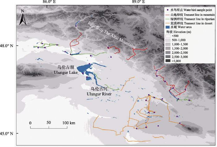
图1
中国阿勒泰地区鸟类调查样线及样点分布图
Fig. 1
Transect lines and bird sample points in Altay Region, China
在晴好天气, 日出后4 h内和日落前3 h内进行鸟类调查。在山地和河岸绿洲生境内步行, 记录样线两侧50 m范围内出现的鸟类物种、个体数、行为、观察距离、经纬度、海拔和生境信息, 步行速度为2 km/h。在荒漠开阔地区, 除步行外, 也开车考察记录所见鸟类, 车速为10 km/h。除样线调查外, 我们也在去往各地的途中随时记录所见鸟类。在湿地与水域生境, 采用定点观察法。在晴好天气记录所有可见鸟类, 较大的水域则选取多个观察点。所调查的水域生境包括富蕴县野布湖、两河源地区、可可苏里湖、依里木湖、可可托海湿地、科克苏湿地, 布尔津县城区、喀纳斯湖, 哈巴河县哈巴河湿地、哈巴河、白沙湖, 福海县城区、乌伦古湖, 青河县城区、北塔山、布尔根河、三道海子, 以及乌伦古河和额尔齐斯河各流域。可可托海和贾登峪地区的样线和水域只分别于2015和2016年内于不同日期调查两次, 其他各地区的样线和水域至少调查两年, 每年调查两次。整个地区样线总长度约为650 km, 鸟类记录点为892个。调查人员包括第一作者和1-3名野外工作助手, 所有人员对当地鸟类有一定辨识经验。
除实地调查外, 通过中国知网检索包含“新疆”、“阿勒泰”或“阿尔泰山”和“鸟类”的关键词, 搜索相关文献、书籍, 以及观鸟爱好者观察记录、图片信息, 主要查阅荒野新疆(
2.2 鸟类物种统计和区系成分分析
2.3 鸟类丰富度分布格局预测
采用最大熵模型预测阿勒泰地区鸟类物种丰富度分布格局。
2.3.1 物种分布数据收集和处理
在野外调查记录到的鸟类物种中(水鸟除外), 剔除分布位点数少于5个的物种, 以减少采样偏差; 将大于5个的鸟类物种的记录点放入1 km2栅格图层中, 用Excel和ArcGIS软件对所有分布点进行反复核查以确定每个1 km栅格仅存在1个物种的1个分布点, 以减少空间自相关性; 将核查过的鸟种分布点数据保存为CSV格式, 用于MaxEnt模型运算。
2.3.2 环境变量选取
为运行物种分布模型, 我们共选取4类环境变量数据以表现栖息生境的生物气候特征、地形特征、植被类型和人为影响程度: (1)生物气候变量: 共19个(Bio1-Bio19), 来自于WorldClim 1.4数据库(
2.3.3 模型的选择和使用
使用MaxEnt 3.3.3k (Phillips et al, 2006)软件建立物种分布模型, 主要采用软件默认设置: 规则化乘数(regularization multiplier)为1; 最大迭代次数(maximum iterations)为500; 收敛阈值(convergence threshold)为10-5; 最大背景点数量(maximum number of background points)设为10,000等, 研究证明这些设置能保证模型运行良好(Phillips & Dudík, 2008)。此外, 我们设置重复运行类别为交叉验证法, 随机测试数据百分比为20%, 依据发生数据量进行自动特征选择(auto feature function)。我们选择Logistic格式的输出结果, 以使每个栅格取值在0 (最不适宜)到1 (最适宜)之间, 以方便模型分析解释。使用刀切法(Jackknife procedure)评价在模拟每个鸟类物种潜在分布区时各个预测变量的相对贡献, 即剔除其他变量并单独使用某变量时模型的规则化收获(regularized gain)。最后整合10次交叉验证模型的结果计算每个栅格的平均适宜性(出现概率), 得到每个物种最终的潜在分布区域。
2.3.4 鸟类物种丰富度分布格局建立
AUC (area under the receiving operator curve)值是受试者工作特征曲线(receiver operating characteristic plot, ROC)下面积, 与阈值选择无关, 是被广泛应用的独立的模型精度测量方法(Wisz et al, 2008; Anderson & Raza, 2010)。AUC值越大, 表示该物种分布越偏离随机分布, 模型预测结果越可信。我们计算多次模拟的平均AUC值以评价模型表现, 选取AUC > 0.7 (Swets, 1988; Araujo et al, 2005)的鸟类物种空间分布预测结果来建立中国阿勒泰地区鸟类物种分布格局。为将鸟类的分布预测结果的图层进行二值化处理, 即每个栅格中该种鸟类有(值为1)或无(值为0), 需要确定阈值。不同阈值确定方法对预测结果造成极大差异, 但至今尚没有公认的最适阈值计算方法。我们选择最小训练存在法确定阈值, 它是一种高度保守的方法, 阈值估算偏高(Svenning et al, 2008)。如果栅格值大于阈值, 则被视为高度适宜。使用ArcGIS软件将每个栅格的平均适宜性根据阈值进行二值化处理, 最终得到该种鸟类在阿勒泰的潜在分布区。将所有物种的二值分布图进行空间栅格叠加, 获得阿勒泰地区鸟类物种丰富度的分布格局。
3 结果
3.1 鸟类物种统计
阿勒泰地区有鸟类19目55科149属344种(附录1)。其中实地调查记录到的鸟类236种, 共计32,854只次。2014年在科克苏湿地国家级自然保护区观察到1只池鹭(Ardeola bacchus), 2013、2014、2016年分别在科克苏、小东沟及布尔津地区记录到大嘴乌鸦(Corvus macrorhynchos)共22只次, 以上均为阿勒泰地区鸟类新记录。记录到的阿勒泰地区鸟类物种中, 新疆省级一级保护动物有11种, 二级保护动物8种; 国家一级重点保护野生动物9种, 国家二级重点保护野生动物60种; IUCN濒危物种红色名录受威胁物种11种; 《中国生物多样性红色名录——脊椎动物卷》受威胁物种30种。
阿勒泰地区鸟类以雀形目居多, 有163种, 占该地区鸟类总种数的47.4%。鸻形目次之, 47种, 占13.7%; 鹰形目29种, 隼形目8种, 共占10.8%; 雁形目23种, 占6.7%; 鹤形目10种, 占2.9%; 鸡形目12种, 占3.4%; 其他各目52种, 占14.9% (鴷形目9种, 鸮形目10种, 鸽形目8种, 鹳形目6种, 䴙䴘目5种, 佛法僧目3种, 鹈形目3种, 鹃形目2种, 雨燕目2种, 沙鸡目2种, 戴胜目1种, 夜鹰目1种)。
从居留类型来看, 阿勒泰地区夏候鸟居多, 有145种, 占42.2%; 有88种(占25.6%)在新疆北部地区为留鸟, 但阿尔泰山区冬季寒冷, 这些鸟类在阿尔泰山地的居留情况还需进一步调查才能确定; 旅鸟58种, 占18.6%; 冬候鸟32种, 占11.1%; 偶见鸟、迷鸟11种。2014年在科克苏湿地记录到普通秧鸡(Rallus aquaticus)、黑水鸡(Gallinula chloropus)、白骨顶(Fulica atra)、凤头麦鸡(Vanellus vanellus)亲鸟带幼鸟觅食及栖息行为, 在北塔山地区记录到白背矶鸫(Monticola saxatilis)的育雏行为; 2015年于福海记录到黑翅长脚鹬(Himantopus himantopus)亲鸟及约10日龄幼鸟; 在卡拉麦里地区记录到金眶鸻(Charadrius dubius)亲鸟及幼鸟。此前这些鸟类在上述地区没有确切的繁殖记录。
3.2 鸟类区系成分
从分布型来看, 阿勒泰地区的鸟类以北方型为主, 共170种, 占鸟类总数的49.4%, 其中古北型(U) 110种, 全北型(C) 60种。其他分布型的鸟类数量由高到低依次为: 广布种(O) 93种, 占27.0%; 中亚型(D) 33种, 占9.6%; 东北型(M) 21种, 占6.1%; 高地型(P) 8种, 占2.3%; 东洋型(W) 8种, 占2.3%; 季风型(E) 1种, 为山斑鸠(Streptopelia orientalis); 喜马拉雅-横断山型(H) 3种, 为灰背伯劳(Lanius tephronotus)、黑冠山雀(Parus rubidiventris)和高原岩鹨(Prunella himalayana)。在阿尔泰山地共分布鸟类297种, 以北方型为主, 共160种: 其中古北型102种, 全北型58种, 繁殖鸟类分别占81.4%和67.2%; 中亚型鸟类24种, 其中繁殖鸟类22种; 高地型10种, 全部能在本地繁殖(图2)。山前平原地区包括绿洲与荒漠生境, 共分布鸟类278种, 其中古北型92种, 全北型49种, 中亚型30种, 繁殖鸟类分别占各分布型的78.3%、59.2%和87.1% (图2)。
图2
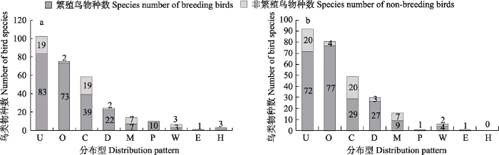
图2
阿尔泰山地(a)和山前平原地区(b)不同分布型鸟类物种数。U: 古北型; O: 广布种; C: 全北型; D: 中亚型; M: 东北型; P: 高地型; W: 东洋型; E: 季风型; H: 喜马拉雅-横断山型。
Fig. 2
Distribution patterns of birds in the Altai Mountains (a) and the plain areas (b) in the south of the Altai Mountains. U, Palearctic Type; O, Widespread Type; C, Holarctic Type; D, Central Asia Type; M, Northeast China Type; P, Highland Type; W, Oriental Type; E, Monsoon Region Type; H, Himalaya-Hengduan Mountains Type.
3.3 鸟类物种丰富度分布格局
3.3.1 不同生境类型中鸟类物种丰富度
根据实地调查并查阅资料, 阿尔泰地区鸟类物种数在垂直海拔带上分别为高山裸岩带24种, 高山草甸带35种, 山地森林草原带172种, 低山灌木带130种, 荒漠草原带84种, 平原绿洲带173种。上述植被带的鸟类均不包含䴙䴘目、雁形目、鹤形目、鸻形目的水鸟, 在各植被带的湿地和水域生境中共统计到92种水鸟(图3)。
图3
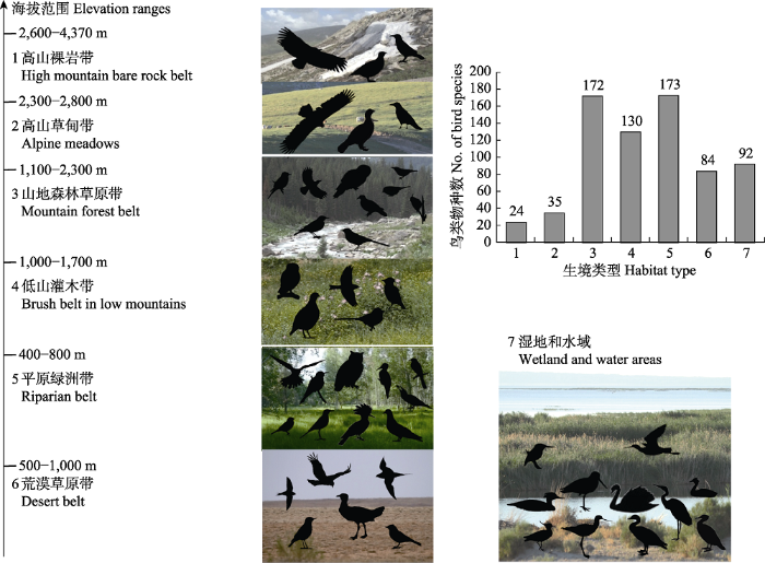
图3
中国阿勒泰地区沿海拔分布的生境类型及其中鸟类物种丰富度
Fig. 3
Bird species richness in habitat types along elevation gradients in Altay Region, China
在实地调查中, 高山裸岩带共记录到鸟类16种, 代表种类有秃鹫(Aegypius monachus)、高山兀鹫(Gyps himalayensis)、红嘴山鸦(Pyrrhocorax pyrrhocorax)、岩雷鸟(Lagopus muta); 高山草甸带共记录到鸟类28种, 常见物种有白鹡鸰(Motacilla alba)和黑耳鸢(Milvus migrans); 山地森林草原带共记录鸟类119种, 数量较多的有苍头燕雀(Fringilla coeleds)、赤颈鸫(Tudus ruficollis)、灰眉岩鹀(Emberiza cia)、斑鹟(Muscicapa striata)、普通朱雀(Carpodacus erythrinus)、灰鹡鸰(Motacilla cinerea); 低山灌木带共记录鸟类101种, 数量较多的有黑喉石䳭(Saxicola maurus)、新疆歌鸲(Luscinia megarhynchos)等; 荒漠草原带共记录鸟类68种, 普通鵟(Buteo japonicus)、白腹毛脚燕(Delichon urbicum)、角百灵(Eremophila alpestris)、毛腿沙鸡(Syrrhaptes paradoxus)、蒙古沙雀(Bucanetes mongolicus)、普通楼燕(Apus apus)、石鸡(Alectoris chukar)等数量较多; 平原绿洲带共记录鸟类124种, 红隼(Falco tinnunculus)、黄爪隼(Falco naumanni)、黄喉蜂虎(Merops apiaster)、蓝胸佛法僧(Coracias garrulus)、紫翅椋鸟(Sturnus vulgaris)、原鸽(Columba livia)等都为常见鸟类; 在各植被带的湿地与水域共记录水鸟62种, 不仅物种丰富, 数量也较大, 赤麻鸭(Todorna ferruginea)、赤膀鸭(Anas strepera)、赤嘴潜鸭(Netta tufina)、黑鹳(Ciconia nigra)、大白鹭(Ardae alba)、灰雁(Anser anser)、银鸥(Larus cachinnans)数以百计, 大天鹅(Cygnus cygnus)、蓑羽鹤(Crus vigo)、白鹈鹕(Pelecanus onocrotalus)、凤头麦鸡(Venellus venellus)、金眶鸻、黑翅长脚鹬、普通燕鸥(Sterna hirundo)等也较常见(图3)。
3.3.2 基于MaxEnt模型的鸟类物种丰富度分布格局
图4
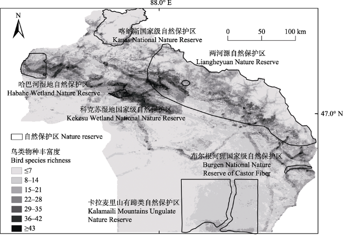
图4
阿勒泰地区鸟类物种多样性分布格局
Fig. 4
Bird species diversity distribution pattern in Altay Region, China
表1 环境因子对鸟类分布模型预测的贡献百分比
Table 1
| 环境因子 Environmental factors | 环境因子描述 Description of environmental factors | 贡献百分比 Percent contribution (%) |
|---|---|---|
| LCT | 土地覆被类型 Land cover type | 23.17 |
| HFI | 人类足迹指数 Human footprint index | 19.73 |
| Altitude | 海拔 Elevation | 8.91 |
| Slope | 坡度 Slope | 6.75 |
| Bio15 | 降水量变异系数 Variation coefficient of precipitation | 4.41 |
| Bio2 | 昼夜温差月均值 Monthly mean of diurnal temperature range | 3.62 |
| Bio12 | 年均降水量 Average annual precipitation | 3.55 |
| Bio14 | 最干月降水量 Precipitation of driest month | 3.14 |
| Bio1 | 年均温 Annual average temperature | 2.97 |
| Bio9 | 最旱季均温 Mean temperature of driest quarter | 2.87 |
| Aspect | 坡向 Aspect | 2.26 |
| Bio3 | 等温线 Isothermality | 2.21 |
| Bio6 | 最冷月最低温 Min temperature of coldest month | 1.89 |
| Bio16 | 最湿季降水量 Precipitation of wettest quarter | 1.83 |
| Bio8 | 最湿季均温 Mean temperature of wettest quarter | 1.78 |
| Bio19 | 最冷季降水 Precipitation of coldest quarter | 1.56 |
| Bio4 | 季节温度变化 Variation of temperature seasonality | 1.54 |
| Bio11 | 最冷季均温 Mean temperature of coldest quarter | 1.45 |
| Bio18 | 最暖季降水 Precipitation of warmest quarter | 1.38 |
| Bio10 | 最暖季均温 Mean temperature of warmest quarter | 1.34 |
| Bio13 | 最湿月降水量 Precipitation of wettest month | 0.99 |
| Bio7 | 气温年较差 Range of annual temperature | 0.92 |
| Bio17 | 最旱季降水量 Precipitation of driest quarter | 0.77 |
| Bio5 | 最暖月最高温 Max temperature of warmest month | 0.63 |
4 讨论
4.1 鸟类物种丰富度
阿勒泰地区生境类型多样, 不同生境鸟类丰富度差异极大(图3, 图4)。向礼陔和黄人鑫(1986)记录阿尔泰山高山及亚高山草甸草原带鸟类11种, 山地森林草原带鸟类107种, 低山灌木草原带鸟类92种, 盆地绿洲荒漠带鸟类103种; 邓杰等(1995)记录高山裸岩地带鸟类15种, 高山草甸带20种, 森林地带86种, 低山灌丛带53种, 荒漠地带51种, 河谷绿洲带84种。在我们的研究中, 通过多种调查方法得到的阿勒泰地区和各生境中鸟类物种数都高于前人研究。阿勒泰地区记录的鸟类物种数逐渐增加, 如此项调查中我们发现了阿勒泰新记录种池鹭和大嘴乌鸦, 2015年在三道海子观测到疑似帆背潜鸭(Aythya valisneria) 5只。不同生境中鸟类物种丰富度的实地调查、资料总结与MaxEnt模型预测结果一致: 平原绿洲带、山地森林草原带和低山灌木带鸟类物种丰富度高。但是由于森林生境调查不充分、一些地区的地形难以布设样线, 调查记录到的鸟类物种要低于实际情况。从整体上来看, 土地覆被类型和人类足迹指数对鸟类物种丰富度预测能力较强, 而不同的鸟类对我们选取的环境变量有不同的敏感程度。
土地覆被类型对灰蓝山雀(Parus cyanus)、乌鸫(Turdus merula)、布氏苇莺(Acrocephalus dumetorum)、极北柳莺(Phylloscopus borealis)、叽咋柳莺(P. collybita tristis)、暗绿柳莺(P. trochiloides)和白喉林莺(Sylvia curruca)等鸟类分布的预测有很大贡献。我们用线性回归模型探索不同植被覆盖类型对鸟类物种丰富度的预测能力, 结果表明包含林下灌木、树木幼苗的林区对保护鸟类多样性有重要的意义(Li et al, 2019)。大鵟(Buteo hemilasius)、白腰雨燕(Apus pacificus)、短趾百灵(Calandrella cheleensis)、沙䳭(Oenanthe isabellina)、白顶䳭(O. pleschanka)和红嘴山鸦(Pyrrhocorax pyrrhocorax)等鸟类对气候变量反应敏感, 全球气候变化可能会导致这些鸟类的分布范围改变。
阿尔泰山地植被多样, 鸟类物种数达297种, 占阿勒泰地区鸟类总数的86.3%; 平原绿洲地区湿地和水域面积广阔(约5万km2), 鸻形目、雁形目、鹤形目等水鸟占阿勒泰地区鸟类的27.3%, 是鸟类迁徙、繁殖的重要驿站。该地区面临全球气候变化与经济发展的双重压力。当地居民的放牧活动对树木幼苗、灌丛损害较严重, 造成鸟类生境丧失和破碎化, 不利于生物多样性保育。此外, 平原绿洲地区鸟类物种丰富, 而这些区域承载着较山区更大的放牧压力。因此, 加强对阿勒泰地区尤其是平原绿洲地区的乔木、灌木及幼苗的保护, 对保护鸟类多样性具有重要的意义。
4.2 鸟类区系特征
阿尔泰山地是我国仅存的古北界南西伯利亚动植物区系分布区(袁国映, 1986)。本文对鸟类区系成分分析的结果与向礼陔和黄人鑫(1986)、高行宜等(1987)、解焱等(2002)和周鹿①(①周鹿 (2015) 新疆及其邻近地区两栖爬行动物地理区划和分布型研究. 硕士学位论文, 新疆农业大学, 乌鲁木齐.)一致, 即阿尔泰山显示出以北方泰加林鸟类为主的独特区系特征。虽然阿尔泰山地与蒙新区接壤, 二者有很多相似的成分, 但也有自己独特的物种成分(向礼陔和黄人鑫, 1986), 因此, 阿尔泰山地属于古北界欧洲-西伯利亚亚界阿尔泰-萨彦岭区阿尔泰亚区; 山前平原地区属于古北界中亚亚界蒙新区西部荒漠亚区。
此地区鸟类不仅具有几个地理分区的鸟类区系特征, 也有一些在中国狭域分布的鸟种, 如柳雷鸟(Lagopus lagopus)、岩雷鸟(L. mutus)和阿尔泰雪鸡(Tetraogallus altaicus) (马鸣, 1999)。但此次调查中并未见阿尔泰雪鸡。这可能是因为高山裸岩地区样线设置较少, 调查时间不充分。此外, 阿尔泰雪鸡在冬季会下降至海拔较低的山地, 然而由于天气寒冷和积雪覆盖, 我们并未于冬季进行鸟类调查。阿尔泰雪鸡分布于阿尔泰山脉至蒙古的东北部山区(马敬能等, 2000), 我国于1990年在新疆北塔山发现, 根据Zabelin (2007)估计, 阿尔泰地区共分布阿尔泰雪鸡约5,500只。除黄人鑫等(1992)在北塔山地区曾观察阿尔泰雪鸡, 新疆境内的阿尔泰山至今尚未发现阿尔泰雪鸡的踪迹。在2013年我们对北塔山野生动物保护站的访问中, 管护人员告知当地有阿尔泰雪鸡分布。
附录 Supplementary Material
附录1 中国阿勒泰地区鸟类名录及物种信息
Appendix 1 Avian species census and species information in the Altay Region, China
致谢:
感谢新疆卡拉麦里山有蹄类自然保护区对野外工作的支持。感谢中国科学院新疆生态与地理研究所的马鸣老师在鸟类识别上给予的帮助。感谢白硕、蒙坎、端肖楠、刘宁娜、吴兵、崔绍朋、陶夏秋、汤宋华、陈静的野外工作协助。感谢崔绍朋、黄元骏在GIS分析上给予的帮助。
参考文献
The effect of the extent of the study region on GIS models of species geographic distributions and estimates of niche evolution: Preliminary tests with montane rodents (genus Nephelomys) in Venezuela
DOI:10.1111/jbi.2010.37.issue-7 URL [本文引用: 1]
Validation of species-climate impact models under climate change
DOI:10.1111/gcb.2005.11.issue-9 URL [本文引用: 1]
Diversity and fauna characteristics of the birds and mammals in mountain areas of Xinjiang
新疆山地鸟类和哺乳类多样性及其区系特征
Hodgson’s bushchat Saxicola insignis in the Mongolian Altai
The adder Vipera berus in Southern Altay Mountains: Population characteristics, distribution, morphology and phylogenetic position
Predicting the potential distribution of white-lipped deer using the MaxEnt model
基于MaxEnt模型预测白唇鹿的潜在分布区
Research on birds of Altai Region, Northern Xinjiang Uigur Autonomous Region
新疆北部阿尔泰地区鸟类调查研究
Distribution and habitat suitability assessment of the gaur Bos gaurus in China
DOI:10.17520/biods.2018012
URL
[本文引用: 1]

Gaur (Bos gaurus) are found in the Yunnan Province and Zangnan in southern Tibet in China. We conducted two field surveys in Xishuangbanna, Pu’er and Mt. Gaoligongshan in Yunnan Province, from February to March and November to December in 2016. We collected 47 valid occurrence locations of gaur by combining survey data and records from literature. Our analysis suggests that there are 180-210 gaurs in the Yunnan Province which face a serious survival crisis. No gaur signs were found in Mt. Gaoligongshan. Next, we used MaxEnt models to predict the potentially suitable habitats for gaur. We grouped 14 habitat predictor variables into five classes—terrain, land cover type, human footprint index, the distance to water and road, as well as climatic factors, and determined the contribution of each habitat factor to habitat suitability for gaur. The accuracy of our prediction models was accessed by the area under the curve (AUC) values for a receiver operating characteristic (ROC) curve. The validation showed that the results had high average AUC value of 0.994. The simulated potential habitat was divided into four classes—the most suitable habitat, moderately suitable habitat, low suitability habitat, and unsuitable habitat. The most suitable habitats for gaur are mainly located in southern Yunnan and Zangnan and spanned 4,987 km² and 13,995 km² respectively. Habitats with moderate suitability (total area = 32,778 km²) were located in the marginal areas of the most suitable habitats and in the Mt. Gongligongshan area. The most suitable habitats were mixed with habitat patches of moderate and low suitability for gaur in the southern parts of Xishuangbanna. In contrast, the central and northern parts of the study area were classified entirely as low suitable habitats and unsuitable habitats. The results of a Jackknife test indicated that temperature seasonality and isothermality had the strongest influence on habitat suitability for gaur, whereas terrain factor and precipitation had little effect. Temperature difference, land cover type and human footprint index were the main variables that explained patterns of gaur distribution. The results of land cover classification (using remote sensing) showed that rubber plantations have fragmented the suitable habitat and reduced landscape connectivity for gaur. We recommend that the relevant management authorities should protect natural forests, control the development of rubber plantations and other agricultural development in habitats suitable for gaur, and improve landscape connectivity to restore gaur populations in the landscape.
印度野牛在中国的分布及栖息地适宜性分析
DOI:10.17520/biods.2018012
URL
[本文引用: 1]
Gaur (Bos gaurus) are found in the Yunnan Province and Zangnan in southern Tibet in China. We conducted two field surveys in Xishuangbanna, Pu’er and Mt. Gaoligongshan in Yunnan Province, from February to March and November to December in 2016. We collected 47 valid occurrence locations of gaur by combining survey data and records from literature. Our analysis suggests that there are 180-210 gaurs in the Yunnan Province which face a serious survival crisis. No gaur signs were found in Mt. Gaoligongshan. Next, we used MaxEnt models to predict the potentially suitable habitats for gaur. We grouped 14 habitat predictor variables into five classes—terrain, land cover type, human footprint index, the distance to water and road, as well as climatic factors, and determined the contribution of each habitat factor to habitat suitability for gaur. The accuracy of our prediction models was accessed by the area under the curve (AUC) values for a receiver operating characteristic (ROC) curve. The validation showed that the results had high average AUC value of 0.994. The simulated potential habitat was divided into four classes—the most suitable habitat, moderately suitable habitat, low suitability habitat, and unsuitable habitat. The most suitable habitats for gaur are mainly located in southern Yunnan and Zangnan and spanned 4,987 km² and 13,995 km² respectively. Habitats with moderate suitability (total area = 32,778 km²) were located in the marginal areas of the most suitable habitats and in the Mt. Gongligongshan area. The most suitable habitats were mixed with habitat patches of moderate and low suitability for gaur in the southern parts of Xishuangbanna. In contrast, the central and northern parts of the study area were classified entirely as low suitable habitats and unsuitable habitats. The results of a Jackknife test indicated that temperature seasonality and isothermality had the strongest influence on habitat suitability for gaur, whereas terrain factor and precipitation had little effect. Temperature difference, land cover type and human footprint index were the main variables that explained patterns of gaur distribution. The results of land cover classification (using remote sensing) showed that rubber plantations have fragmented the suitable habitat and reduced landscape connectivity for gaur. We recommend that the relevant management authorities should protect natural forests, control the development of rubber plantations and other agricultural development in habitats suitable for gaur, and improve landscape connectivity to restore gaur populations in the landscape.
Monitoring birds and mammals through camera traps in Mount Kalamaili Ungulate Nature Reserve, Xinjiang
卡拉麦里山有蹄类自然保护区鸟兽的红外相机监测
Question about avian fauna and zoogeography division in the Altai Mountains, Xinjiang
新疆阿尔泰山地鸟类区系与动物地理区划问题
The impacts of climate change on the wintering distribution of an endangered migratory bird
A new record of birds from China—Altai snowcock
中国鸟类新纪录——阿尔泰雪鸡
Question about the distributions of Tibetan partridge Perdix hodgsoniae in Xinjiang
关于高原山鹑在新疆的分布问题
Golden eagle in the Altai-Sayan Region, Russia
The species and distribution of birds in Xinjiang and its micro-computer information system
新疆鸟类种类与分布及其微机信息系统
Bird species diversity in Altai riparian landscapes: Wood cover plays a key role for avian abundance
Important bird areas (IBAs) and globally threatened birds in Xinjiang, China
新疆的国际性濒危鸟类及重要鸟区
Animal fauna in Jintasi Glassland Nature Reserve in Altai Mountains
阿尔泰山金塔斯草原自然保护区的动物类型
Little gull breeding population first detected in north Xinjiang
新疆北部首次发现小鸥繁殖种群
The Global 200: Priority ecoregions for global conservation
Maximum entropy modeling of species geographic distributions
Modeling of species distributions with MaxEnt: New extensions and a comprehensive evaluation
Niche breadth and geographic range size as determinants of species survival ongeological time scales
Glacial refugia of temperate trees in Europe: Insights from species distribution modelling
DOI:10.1111/jec.2008.96.issue-6 URL [本文引用: 1]
Eastern marsh harrier Circus spilonotus, a new record of bird from Xinjiang
The Eastern Marsh Harriers(Circus spilonotus)were recorded several times at Burqin County, Altay Prefecture, Xinjiang now it was identified as a new record of bird in Xinjiang. However, in the breeding period from May to July, 2015, a nest was found in Burqin(47°46'33″N, 86°49'25″E)that the female may be related to Western Marsh Harriers(Circus aeruginosus)such as a hybrid harrier. Both in morphology and behavior, or in the geographic isolation, there are many doubts about the Eastern Marsh Harriers(Circus spilonotus)and Western Marsh Harriers(Circus aeruginosus), and their taxonomic is worth for study.
新疆鸟类新纪录——白腹鹞(Circus spilonotus)
The Eastern Marsh Harriers(Circus spilonotus)were recorded several times at Burqin County, Altay Prefecture, Xinjiang now it was identified as a new record of bird in Xinjiang. However, in the breeding period from May to July, 2015, a nest was found in Burqin(47°46'33″N, 86°49'25″E)that the female may be related to Western Marsh Harriers(Circus aeruginosus)such as a hybrid harrier. Both in morphology and behavior, or in the geographic isolation, there are many doubts about the Eastern Marsh Harriers(Circus spilonotus)and Western Marsh Harriers(Circus aeruginosus), and their taxonomic is worth for study.
Nesting habitat suitability analysis of red-crowned crane in Zhalong Nature Reserve based on MaxEnt modeling
基于MaxEnt模型的丹顶鹤营巢生境适宜性分析——以扎龙保护区为例
Effects of sample size on the performance of species distribution models
DOI:10.1111/ddi.2008.14.issue-5 URL [本文引用: 1]
Study on birds in the Altai of Xinjiang. I. Distribution of birds
新疆阿尔泰山鸟类的研究(I)—鸟类的分布
Preliminary researches on bio-geographical divisions of China
中国生物地理区划研究
Two new bird records in Xinjiang—Oriental plover Charadrius veredus and common ringed plover Charadrius hiaticula
新疆鸟类新纪录二种——东方鸻、剑鸻
The vertical zonation of the western Altai Mountains
阿尔泰山西部地区的垂直自然带
Global climate change will severely decrease potential distribution of the East Asian coldwater fish Rhynchocypris oxycephalus (Actinopterygii, Cyprinidae)
Ecological features of species range formation in the Altai snowcock
Asian brown flycatcher Muscica padauurica—A new record in Xinjiang
北灰鹟——新疆鸟类新纪录
