1 State Key Laboratory of Vegetation and Environmental Change, Institute of Botany, Chinese Academy of Sciences, Beijing 1000932 University of Chinese Academy of Sciences, Beijing 1000493 Urban Construction School, Beijing City University, Beijing 1000834 College of Resource and Environment Sciences, Xinjiang University, Urumqi 830046
通讯作者: * 通讯作者 Author for correspondence. E-mail: qguo@ibcas.ac.cn
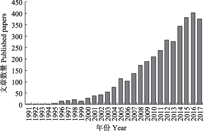
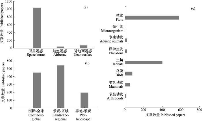
Since rapid human population growth, overconsumption of natural resources by human activities and climate change, loss and extinction of species is increasing, and biodiversity become an important global issue. Traditional ground-based biodiversity researches focus on the species or community, which can not provide necessary information for biodiversity conservation and assessment at a large scale. Since the advantages in spatial coverage and time series, remote sensing is very useful in large-scale biodiversity monitoring, mapping and assessment. According to the height of the platform, remote sensing platforms can be classified into satellite remote sensing, airborne remote sensing and near-surface remote sensing, which can obtain biodiversity information at different spatial scales. The purpose of this study is to review the recent advances of application of different remote sensing platforms for biodiversity research. We focus on the following aspects, such as observation methods, research scale, and analyze advantages and limitations of different remote sensing platforms. Finally, we summary the future application of remote sensing in biodiversity research. From the literature statistics result, we found that satellite platform were used more frequently in biodiversity research than other remote sensing platform. Due to the high flight cost, the biodiversity researches used airborne remote sensing was fewer than the researches used satellite. Near-surface remote sensing includes the UAV platform and the ground-based platform, which is an emerging remote sensing platform and hotspot in remote sensing of biodiversity. Compared to satellite and airborne remote sensing platforms, the near-surface remote sensing platform can directly observe the individuals and can directly obtain information from species or population. Although there are some limitations in these three platforms, we believe that remote sensing technology can better serve biodiversity conservation and assessment from different temporal and spatial scales with the development of remote sensing platforms and the improvement of sensors.
An automated procedure for estimating the leaf area index (LAI) of woodland ecosystems using digital imagery, MATLAB programming and its application to an examination of the relationship between remotely sensed and field measurements of LAI
A remote sensing-based approach to estimating montado canopy density using the FCD model: A contribution to identifying HNV farmlands in southern Portugal
Mapping species density of trees, shrubs and vines in a tropical forest, using field measurements, satellite multiespectral imagery and spatial interpolation
Spatial distribution of forest aboveground biomass in China: Estimation through combination of spaceborne Lidar, optical imagery, and forest inventory data
Fine-resolution forest tree height estimation across the Sierra Nevada through the integration of spaceborne LiDAR, airborne LiDAR, and optical imagery
. International Journal of Digital Earth, 10, 307-323.
Tracking fragmentation of natural communities and changes in land cover: Applications of Landsat data for conservation in an urban landscape (Chicago Wilderness)
Detectability and categorization of California sea lions using an unmanned aerial vehicle
1
2017
... 无人机平台用于开展动物多样性研究具有独特的优势, 尤其是大型动物的种群数量和动物保护方面.Vermeulen等(2013)用无人机对非洲西部的非洲象进行监测, 共监测到34头大象.Mulero-Pazmany等(2014)将无人机用作犀牛反偷猎的工具, 使其成为非洲生物多样性保护的利器.对于海洋动物无人机也能发挥重要作用.研究者分别用无人机对海豹(Krause et al, 2017)、海狮(Adame et al, 2017)、海龟(Schofield et al, 2017)、儒艮(Hodgson et al, 2013)等海洋哺乳动物进行了监测.除了直接监测动物的数据和分布, 无人机平台还能更细致地获取生境信息用于各种动物的栖息地研究, 如黑猩猩(Pongo abelii) (Szantoi et al, 2017)、鲨鱼(Carcharhinus melanopterus and Himantura fai) (Kiszka et al, 2016)、鳄鱼(Crocodylus porosus)(Evans et al, 2015)等.Sarda-Palomera等(2012)在无人机鸟类监测研究中也已取得了明显的进展.此外还有人专门研究了无人机监测对野生动物的干扰(Brisson-Curadeau et al, 2017; Mulero-Pazmany et al, 2017). ...
Airborne laser-guided imaging spectroscopy to map forest trait diversity and guide conservation
2
2017
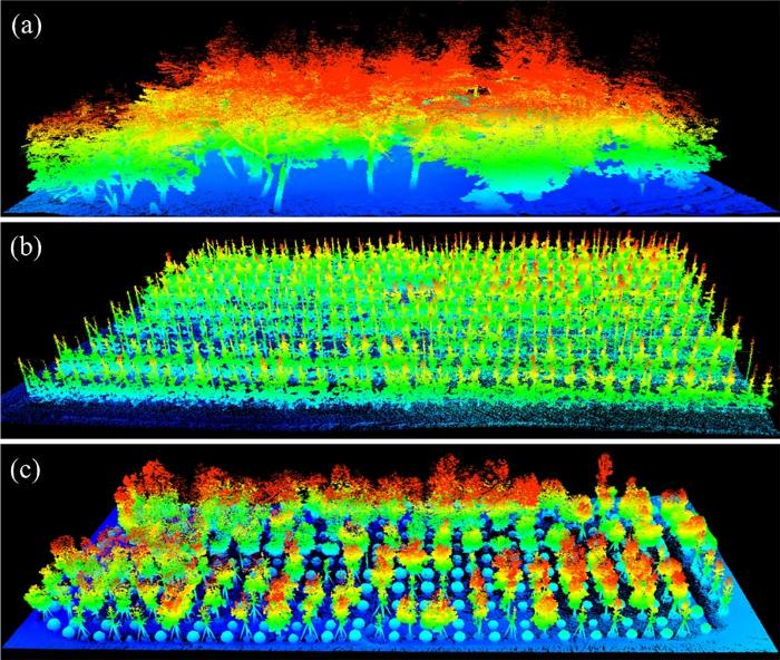
... 航空遥感兼顾了不同尺度水平的数据获取和分析能力, 尤其在景观-区域尺度有着不可比拟的优势, 并广泛应用于生态系统组成、结构和功能研究.在植物多样性研究领域, 主要集中在植被性状(Asner et al, 2017)、植被结构(Coops et al, 2016)、物种识别(Asner & Martin, 2008; Sasaki et al, 2012)以及物种多样性(Carlson et al, 2007; Simonson et al, 2012)等方面.如Carlson等(2007)分析了夏威夷17个森林站点的林冠维管束植物丰富度与高光谱反射率的关系, 并指出与生化组分相关的几个波段特征能够很好地指示物种多样性.Simonson等(2012)利用机载激光雷达获取的冠层结构信息(如植被高度)来衡量物种组成和生物多样性; Coops等(2016)利用机载激光雷达能够精确刻画森林三维结构的优势, 研究了物种分布与森林生境结构的关系, 并提出了高度、覆盖度和复杂度三个森林水平和垂直结构的指数用于表征森林生物多样性水平.航空遥感通常搭载多种传感器, 一次航飞即可获取多类型数据, 进行数据融合后可更好地提取生物多样性信息.Su等(2016b)在美国加州内华达山脉开展了基于机载激光雷达和影像的植被类型制图研究, 利用贝叶斯和K-均值的自动聚类算法的非监督分类方法, 最终发现融入激光雷达数据的分类效果相比于只有光学影像的分类方法更加精确, 能够识别的植被类型更多.Asner等(2017)利用机载激光雷达和高光谱数据获取森林冠层的性状特征, 结合地形气候等环境分析了森林功能多样性的变化.Zhao等(2018)在神农架利用机载激光雷达和高光谱数据, 通过对植物结构特征和生化组分特征聚类来估算生物多样性.目前, 航空遥感很难获取准确的物种信息来反映生物多样性, 而且很多研究反演的物种多样性只是性状特征的聚类, 无法与真实的物种对应而且容易出现饱和现象. ...
Seabird species vary in behavioural response to drone census
1
2017
... 无人机平台用于开展动物多样性研究具有独特的优势, 尤其是大型动物的种群数量和动物保护方面.Vermeulen等(2013)用无人机对非洲西部的非洲象进行监测, 共监测到34头大象.Mulero-Pazmany等(2014)将无人机用作犀牛反偷猎的工具, 使其成为非洲生物多样性保护的利器.对于海洋动物无人机也能发挥重要作用.研究者分别用无人机对海豹(Krause et al, 2017)、海狮(Adame et al, 2017)、海龟(Schofield et al, 2017)、儒艮(Hodgson et al, 2013)等海洋哺乳动物进行了监测.除了直接监测动物的数据和分布, 无人机平台还能更细致地获取生境信息用于各种动物的栖息地研究, 如黑猩猩(Pongo abelii) (Szantoi et al, 2017)、鲨鱼(Carcharhinus melanopterus and Himantura fai) (Kiszka et al, 2016)、鳄鱼(Crocodylus porosus)(Evans et al, 2015)等.Sarda-Palomera等(2012)在无人机鸟类监测研究中也已取得了明显的进展.此外还有人专门研究了无人机监测对野生动物的干扰(Brisson-Curadeau et al, 2017; Mulero-Pazmany et al, 2017). ...
Exploitation of very high resolution satellite data for tree species identification
1
2004
... 目前, 卫星遥感数据主要用于植物和动物多样性研究工作中, 其中在植物多样性研究方面, 以卫星遥感为数据基础的研究主要关注物种组成、生态系统结构和功能三个方面(Martin et al, 1998; Carleer & Wolff, 2004).在研究物种组成方面, Saatchi等(2008)利用多源遥感数据, 结合与植被和气候相关的环境变量信息, 利用最大熵模型预测了亚马逊流域5种树的分布和多样性特征; Wilson等(2012)利用森林清查数据和中分辨率的遥感影像数据(Moderate Resolution Imaging Spectroradiometer, MODIS)研究了大尺度树种组成和分布.然而, 利用卫星遥感开展物种组成研究存在很大的局限性, 很多研究是建立在海量样本的基础上, 例如Wilson等(2012)的研究使用的是美国森林清查数据, 而且遥感数据只是提供了物候的信息.Saatchi等(2008)的研究则是分析部分树种的潜在分布, 与真实的物种分布和组成存在很大差异.在生态系统结构多样性方面, 利用光学影像获取光谱指数反演物种性状是最常用的手段之一(Clerici et al, 2012; Duffy & Pettorelli, 2012), 但受光学遥感的饱和效应影响, 其精度都很低.近年来, 激光雷达、合成孔径雷达技术等主动遥感技术的发展, 为精确测量森林三维结构(如树高、叶面积指数等)、预测生物量等提供了全新的手段(Hu et al, 2016; Su et al, 2016a, 2017).在生态系统功能方面, 主要是利用时间序列的遥感影像监测植被动态变化及其对气候变化的响应等(Jordan et al, 2012; Hutchinson et al, 2015; Lausch et al, 2016).利用卫星研究植被动态通常关注植被类型的变化, 即生态系统多样性, 对于物种尺度的变化研究较少. ...
Hyperspectral remote sensing of canopy biodiversity in Hawaiian lowland rainforests
2
2007
... 航空遥感兼顾了不同尺度水平的数据获取和分析能力, 尤其在景观-区域尺度有着不可比拟的优势, 并广泛应用于生态系统组成、结构和功能研究.在植物多样性研究领域, 主要集中在植被性状(Asner et al, 2017)、植被结构(Coops et al, 2016)、物种识别(Asner & Martin, 2008; Sasaki et al, 2012)以及物种多样性(Carlson et al, 2007; Simonson et al, 2012)等方面.如Carlson等(2007)分析了夏威夷17个森林站点的林冠维管束植物丰富度与高光谱反射率的关系, 并指出与生化组分相关的几个波段特征能够很好地指示物种多样性.Simonson等(2012)利用机载激光雷达获取的冠层结构信息(如植被高度)来衡量物种组成和生物多样性; Coops等(2016)利用机载激光雷达能够精确刻画森林三维结构的优势, 研究了物种分布与森林生境结构的关系, 并提出了高度、覆盖度和复杂度三个森林水平和垂直结构的指数用于表征森林生物多样性水平.航空遥感通常搭载多种传感器, 一次航飞即可获取多类型数据, 进行数据融合后可更好地提取生物多样性信息.Su等(2016b)在美国加州内华达山脉开展了基于机载激光雷达和影像的植被类型制图研究, 利用贝叶斯和K-均值的自动聚类算法的非监督分类方法, 最终发现融入激光雷达数据的分类效果相比于只有光学影像的分类方法更加精确, 能够识别的植被类型更多.Asner等(2017)利用机载激光雷达和高光谱数据获取森林冠层的性状特征, 结合地形气候等环境分析了森林功能多样性的变化.Zhao等(2018)在神农架利用机载激光雷达和高光谱数据, 通过对植物结构特征和生化组分特征聚类来估算生物多样性.目前, 航空遥感很难获取准确的物种信息来反映生物多样性, 而且很多研究反演的物种多样性只是性状特征的聚类, 无法与真实的物种对应而且容易出现饱和现象. ...
... *指标参考以下文献: Turner et al, 2003; Duro et al, 2007; Dassot et al, 2011; Goetz et al, 2014 ...
Use of drone technology as a tool for behavioral research: A case study of crocodilian nesting
1
2015
... 无人机平台用于开展动物多样性研究具有独特的优势, 尤其是大型动物的种群数量和动物保护方面.Vermeulen等(2013)用无人机对非洲西部的非洲象进行监测, 共监测到34头大象.Mulero-Pazmany等(2014)将无人机用作犀牛反偷猎的工具, 使其成为非洲生物多样性保护的利器.对于海洋动物无人机也能发挥重要作用.研究者分别用无人机对海豹(Krause et al, 2017)、海狮(Adame et al, 2017)、海龟(Schofield et al, 2017)、儒艮(Hodgson et al, 2013)等海洋哺乳动物进行了监测.除了直接监测动物的数据和分布, 无人机平台还能更细致地获取生境信息用于各种动物的栖息地研究, 如黑猩猩(Pongo abelii) (Szantoi et al, 2017)、鲨鱼(Carcharhinus melanopterus and Himantura fai) (Kiszka et al, 2016)、鳄鱼(Crocodylus porosus)(Evans et al, 2015)等.Sarda-Palomera等(2012)在无人机鸟类监测研究中也已取得了明显的进展.此外还有人专门研究了无人机监测对野生动物的干扰(Brisson-Curadeau et al, 2017; Mulero-Pazmany et al, 2017). ...
Land use and land cover change in protected areas: Using remote sensing to survey suitable habitats of brown bear Ursus arctos
1
2016
... Biodiversity indicators that can be derived from satellite remote sensing
生物多样性核心指标 Essential biodiversity variables
卫星遥感能获取的指标 Indicators obtained from satellite remote sensing
物种数量 Species populations
物种分布 Species distribution (Saveraid et al, 2001; Leyequien et al, 2007; Shirley et al, 2013; Sequeira et al, 2014)
物种性状 Species traits
叶面积指数 LAI (Fuentes et al, 2008)、氮素含量 Nitrogen content (Ojoyi et al, 2017)等
群落组成 Community composition
物种密度 Species density (Hernández-Stefanoni & Dupuy, 2007; Godinho et al, 2016)、物种丰富度 Species richness (Knudby et al, 2010; Lucas et al, 2010)等
生态系统功能 Ecosystem function
植被绿度 Greenness (Zhou et al, 2014)、植被物候 Phenology (Ganguly et al, 2010)、光合作用能力和生态系统生产力 Photosynthesis and ecosystem productivity (Franklin et al, 2006; Mishra & Chaudhuri, 2015)等
生态系统结构 Ecosystem structure
景观破碎化和异质性 Landscape fragmentation and heterogeneity (Saatchi et al, 2001; Wang & Moskovits, 2001; Tuanmu & Jetz, 2015)、土地覆盖和土地利用 Landcover and land use (Farashi et al, 2016; Zhao et al, 2016)、植被高度 Vegetation height (Su et al, 2017)等
Buffelgrass (Pennisetum ciliare) land conversion and productivity in the plains of Sonora, Mexico
1
2006
... Biodiversity indicators that can be derived from satellite remote sensing
生物多样性核心指标 Essential biodiversity variables
卫星遥感能获取的指标 Indicators obtained from satellite remote sensing
物种数量 Species populations
物种分布 Species distribution (Saveraid et al, 2001; Leyequien et al, 2007; Shirley et al, 2013; Sequeira et al, 2014)
物种性状 Species traits
叶面积指数 LAI (Fuentes et al, 2008)、氮素含量 Nitrogen content (Ojoyi et al, 2017)等
群落组成 Community composition
物种密度 Species density (Hernández-Stefanoni & Dupuy, 2007; Godinho et al, 2016)、物种丰富度 Species richness (Knudby et al, 2010; Lucas et al, 2010)等
生态系统功能 Ecosystem function
植被绿度 Greenness (Zhou et al, 2014)、植被物候 Phenology (Ganguly et al, 2010)、光合作用能力和生态系统生产力 Photosynthesis and ecosystem productivity (Franklin et al, 2006; Mishra & Chaudhuri, 2015)等
生态系统结构 Ecosystem structure
景观破碎化和异质性 Landscape fragmentation and heterogeneity (Saatchi et al, 2001; Wang & Moskovits, 2001; Tuanmu & Jetz, 2015)、土地覆盖和土地利用 Landcover and land use (Farashi et al, 2016; Zhao et al, 2016)、植被高度 Vegetation height (Su et al, 2017)等
An automated procedure for estimating the leaf area index (LAI) of woodland ecosystems using digital imagery, MATLAB programming and its application to an examination of the relationship between remotely sensed and field measurements of LAI
1
2008
... Biodiversity indicators that can be derived from satellite remote sensing
生物多样性核心指标 Essential biodiversity variables
卫星遥感能获取的指标 Indicators obtained from satellite remote sensing
物种数量 Species populations
物种分布 Species distribution (Saveraid et al, 2001; Leyequien et al, 2007; Shirley et al, 2013; Sequeira et al, 2014)
物种性状 Species traits
叶面积指数 LAI (Fuentes et al, 2008)、氮素含量 Nitrogen content (Ojoyi et al, 2017)等
群落组成 Community composition
物种密度 Species density (Hernández-Stefanoni & Dupuy, 2007; Godinho et al, 2016)、物种丰富度 Species richness (Knudby et al, 2010; Lucas et al, 2010)等
生态系统功能 Ecosystem function
植被绿度 Greenness (Zhou et al, 2014)、植被物候 Phenology (Ganguly et al, 2010)、光合作用能力和生态系统生产力 Photosynthesis and ecosystem productivity (Franklin et al, 2006; Mishra & Chaudhuri, 2015)等
生态系统结构 Ecosystem structure
景观破碎化和异质性 Landscape fragmentation and heterogeneity (Saatchi et al, 2001; Wang & Moskovits, 2001; Tuanmu & Jetz, 2015)、土地覆盖和土地利用 Landcover and land use (Farashi et al, 2016; Zhao et al, 2016)、植被高度 Vegetation height (Su et al, 2017)等
Land surface phenology from MODIS: Characterization of the Collection 5 global land cover dynamics product
1
2010
... Biodiversity indicators that can be derived from satellite remote sensing
生物多样性核心指标 Essential biodiversity variables
卫星遥感能获取的指标 Indicators obtained from satellite remote sensing
物种数量 Species populations
物种分布 Species distribution (Saveraid et al, 2001; Leyequien et al, 2007; Shirley et al, 2013; Sequeira et al, 2014)
物种性状 Species traits
叶面积指数 LAI (Fuentes et al, 2008)、氮素含量 Nitrogen content (Ojoyi et al, 2017)等
群落组成 Community composition
物种密度 Species density (Hernández-Stefanoni & Dupuy, 2007; Godinho et al, 2016)、物种丰富度 Species richness (Knudby et al, 2010; Lucas et al, 2010)等
生态系统功能 Ecosystem function
植被绿度 Greenness (Zhou et al, 2014)、植被物候 Phenology (Ganguly et al, 2010)、光合作用能力和生态系统生产力 Photosynthesis and ecosystem productivity (Franklin et al, 2006; Mishra & Chaudhuri, 2015)等
生态系统结构 Ecosystem structure
景观破碎化和异质性 Landscape fragmentation and heterogeneity (Saatchi et al, 2001; Wang & Moskovits, 2001; Tuanmu & Jetz, 2015)、土地覆盖和土地利用 Landcover and land use (Farashi et al, 2016; Zhao et al, 2016)、植被高度 Vegetation height (Su et al, 2017)等
... 自从美国宇航局共享Landsat系列卫星数据以来, 卫星遥感为生态学领域的各类研究提供了观测、分析和预测的数据(Turner et al, 2003; Pettorelli et al, 2014).相比于地面观测, 卫星遥感具有以下几点优势: (1)观测范围大, 能够直接获取全球尺度的数据; (2)能够实现长时间序列的观测和记录; (3)数据类型多样, 数据获取成本低.这些优势有利于生态学家获取物种组成、生态系统结构和功能相关信息, 尤其是长期积累的多源遥感数据为大尺度和长时间序列的生物多样性监测提供了可能(Kerr & Ostrovsky, 2003; Gillespie et al, 2008; Paganini et al, 2016). ...
A remote sensing-based approach to estimating montado canopy density using the FCD model: A contribution to identifying HNV farmlands in southern Portugal
1
2016
... Biodiversity indicators that can be derived from satellite remote sensing
生物多样性核心指标 Essential biodiversity variables
卫星遥感能获取的指标 Indicators obtained from satellite remote sensing
物种数量 Species populations
物种分布 Species distribution (Saveraid et al, 2001; Leyequien et al, 2007; Shirley et al, 2013; Sequeira et al, 2014)
物种性状 Species traits
叶面积指数 LAI (Fuentes et al, 2008)、氮素含量 Nitrogen content (Ojoyi et al, 2017)等
群落组成 Community composition
物种密度 Species density (Hernández-Stefanoni & Dupuy, 2007; Godinho et al, 2016)、物种丰富度 Species richness (Knudby et al, 2010; Lucas et al, 2010)等
生态系统功能 Ecosystem function
植被绿度 Greenness (Zhou et al, 2014)、植被物候 Phenology (Ganguly et al, 2010)、光合作用能力和生态系统生产力 Photosynthesis and ecosystem productivity (Franklin et al, 2006; Mishra & Chaudhuri, 2015)等
生态系统结构 Ecosystem structure
景观破碎化和异质性 Landscape fragmentation and heterogeneity (Saatchi et al, 2001; Wang & Moskovits, 2001; Tuanmu & Jetz, 2015)、土地覆盖和土地利用 Landcover and land use (Farashi et al, 2016; Zhao et al, 2016)、植被高度 Vegetation height (Su et al, 2017)等
Mapping species density of trees, shrubs and vines in a tropical forest, using field measurements, satellite multiespectral imagery and spatial interpolation
1
2007
... Biodiversity indicators that can be derived from satellite remote sensing
生物多样性核心指标 Essential biodiversity variables
卫星遥感能获取的指标 Indicators obtained from satellite remote sensing
物种数量 Species populations
物种分布 Species distribution (Saveraid et al, 2001; Leyequien et al, 2007; Shirley et al, 2013; Sequeira et al, 2014)
物种性状 Species traits
叶面积指数 LAI (Fuentes et al, 2008)、氮素含量 Nitrogen content (Ojoyi et al, 2017)等
群落组成 Community composition
物种密度 Species density (Hernández-Stefanoni & Dupuy, 2007; Godinho et al, 2016)、物种丰富度 Species richness (Knudby et al, 2010; Lucas et al, 2010)等
生态系统功能 Ecosystem function
植被绿度 Greenness (Zhou et al, 2014)、植被物候 Phenology (Ganguly et al, 2010)、光合作用能力和生态系统生产力 Photosynthesis and ecosystem productivity (Franklin et al, 2006; Mishra & Chaudhuri, 2015)等
生态系统结构 Ecosystem structure
景观破碎化和异质性 Landscape fragmentation and heterogeneity (Saatchi et al, 2001; Wang & Moskovits, 2001; Tuanmu & Jetz, 2015)、土地覆盖和土地利用 Landcover and land use (Farashi et al, 2016; Zhao et al, 2016)、植被高度 Vegetation height (Su et al, 2017)等
Unmanned aerial vehicles (UAVs) for surveying marine fauna: A Dugong case study
1
2013
... 无人机平台用于开展动物多样性研究具有独特的优势, 尤其是大型动物的种群数量和动物保护方面.Vermeulen等(2013)用无人机对非洲西部的非洲象进行监测, 共监测到34头大象.Mulero-Pazmany等(2014)将无人机用作犀牛反偷猎的工具, 使其成为非洲生物多样性保护的利器.对于海洋动物无人机也能发挥重要作用.研究者分别用无人机对海豹(Krause et al, 2017)、海狮(Adame et al, 2017)、海龟(Schofield et al, 2017)、儒艮(Hodgson et al, 2013)等海洋哺乳动物进行了监测.除了直接监测动物的数据和分布, 无人机平台还能更细致地获取生境信息用于各种动物的栖息地研究, 如黑猩猩(Pongo abelii) (Szantoi et al, 2017)、鲨鱼(Carcharhinus melanopterus and Himantura fai) (Kiszka et al, 2016)、鳄鱼(Crocodylus porosus)(Evans et al, 2015)等.Sarda-Palomera等(2012)在无人机鸟类监测研究中也已取得了明显的进展.此外还有人专门研究了无人机监测对野生动物的干扰(Brisson-Curadeau et al, 2017; Mulero-Pazmany et al, 2017). ...
Using unmanned aerial vehicles (UAVs) to investigate shark and ray densities in a shallow coral lagoon
1
2016
... 无人机平台用于开展动物多样性研究具有独特的优势, 尤其是大型动物的种群数量和动物保护方面.Vermeulen等(2013)用无人机对非洲西部的非洲象进行监测, 共监测到34头大象.Mulero-Pazmany等(2014)将无人机用作犀牛反偷猎的工具, 使其成为非洲生物多样性保护的利器.对于海洋动物无人机也能发挥重要作用.研究者分别用无人机对海豹(Krause et al, 2017)、海狮(Adame et al, 2017)、海龟(Schofield et al, 2017)、儒艮(Hodgson et al, 2013)等海洋哺乳动物进行了监测.除了直接监测动物的数据和分布, 无人机平台还能更细致地获取生境信息用于各种动物的栖息地研究, 如黑猩猩(Pongo abelii) (Szantoi et al, 2017)、鲨鱼(Carcharhinus melanopterus and Himantura fai) (Kiszka et al, 2016)、鳄鱼(Crocodylus porosus)(Evans et al, 2015)等.Sarda-Palomera等(2012)在无人机鸟类监测研究中也已取得了明显的进展.此外还有人专门研究了无人机监测对野生动物的干扰(Brisson-Curadeau et al, 2017; Mulero-Pazmany et al, 2017). ...
Predictive mapping of reef fish species richness, diversity and biomass in Zanzibar using IKONOS imagery and machine-learning techniques
1
2010
... Biodiversity indicators that can be derived from satellite remote sensing
生物多样性核心指标 Essential biodiversity variables
卫星遥感能获取的指标 Indicators obtained from satellite remote sensing
物种数量 Species populations
物种分布 Species distribution (Saveraid et al, 2001; Leyequien et al, 2007; Shirley et al, 2013; Sequeira et al, 2014)
物种性状 Species traits
叶面积指数 LAI (Fuentes et al, 2008)、氮素含量 Nitrogen content (Ojoyi et al, 2017)等
群落组成 Community composition
物种密度 Species density (Hernández-Stefanoni & Dupuy, 2007; Godinho et al, 2016)、物种丰富度 Species richness (Knudby et al, 2010; Lucas et al, 2010)等
生态系统功能 Ecosystem function
植被绿度 Greenness (Zhou et al, 2014)、植被物候 Phenology (Ganguly et al, 2010)、光合作用能力和生态系统生产力 Photosynthesis and ecosystem productivity (Franklin et al, 2006; Mishra & Chaudhuri, 2015)等
生态系统结构 Ecosystem structure
景观破碎化和异质性 Landscape fragmentation and heterogeneity (Saatchi et al, 2001; Wang & Moskovits, 2001; Tuanmu & Jetz, 2015)、土地覆盖和土地利用 Landcover and land use (Farashi et al, 2016; Zhao et al, 2016)、植被高度 Vegetation height (Su et al, 2017)等
An accurate and adaptable photogrammetric approach for estimating the mass and body condition of pinnipeds using an unmanned aerial system
1
2017
... 无人机平台用于开展动物多样性研究具有独特的优势, 尤其是大型动物的种群数量和动物保护方面.Vermeulen等(2013)用无人机对非洲西部的非洲象进行监测, 共监测到34头大象.Mulero-Pazmany等(2014)将无人机用作犀牛反偷猎的工具, 使其成为非洲生物多样性保护的利器.对于海洋动物无人机也能发挥重要作用.研究者分别用无人机对海豹(Krause et al, 2017)、海狮(Adame et al, 2017)、海龟(Schofield et al, 2017)、儒艮(Hodgson et al, 2013)等海洋哺乳动物进行了监测.除了直接监测动物的数据和分布, 无人机平台还能更细致地获取生境信息用于各种动物的栖息地研究, 如黑猩猩(Pongo abelii) (Szantoi et al, 2017)、鲨鱼(Carcharhinus melanopterus and Himantura fai) (Kiszka et al, 2016)、鳄鱼(Crocodylus porosus)(Evans et al, 2015)等.Sarda-Palomera等(2012)在无人机鸟类监测研究中也已取得了明显的进展.此外还有人专门研究了无人机监测对野生动物的干扰(Brisson-Curadeau et al, 2017; Mulero-Pazmany et al, 2017). ...
Linking Earth Observation and taxonomic, structural and functional biodiversity: Local to ecosystem perspectives
1
2016
... 目前, 卫星遥感数据主要用于植物和动物多样性研究工作中, 其中在植物多样性研究方面, 以卫星遥感为数据基础的研究主要关注物种组成、生态系统结构和功能三个方面(Martin et al, 1998; Carleer & Wolff, 2004).在研究物种组成方面, Saatchi等(2008)利用多源遥感数据, 结合与植被和气候相关的环境变量信息, 利用最大熵模型预测了亚马逊流域5种树的分布和多样性特征; Wilson等(2012)利用森林清查数据和中分辨率的遥感影像数据(Moderate Resolution Imaging Spectroradiometer, MODIS)研究了大尺度树种组成和分布.然而, 利用卫星遥感开展物种组成研究存在很大的局限性, 很多研究是建立在海量样本的基础上, 例如Wilson等(2012)的研究使用的是美国森林清查数据, 而且遥感数据只是提供了物候的信息.Saatchi等(2008)的研究则是分析部分树种的潜在分布, 与真实的物种分布和组成存在很大差异.在生态系统结构多样性方面, 利用光学影像获取光谱指数反演物种性状是最常用的手段之一(Clerici et al, 2012; Duffy & Pettorelli, 2012), 但受光学遥感的饱和效应影响, 其精度都很低.近年来, 激光雷达、合成孔径雷达技术等主动遥感技术的发展, 为精确测量森林三维结构(如树高、叶面积指数等)、预测生物量等提供了全新的手段(Hu et al, 2016; Su et al, 2016a, 2017).在生态系统功能方面, 主要是利用时间序列的遥感影像监测植被动态变化及其对气候变化的响应等(Jordan et al, 2012; Hutchinson et al, 2015; Lausch et al, 2016).利用卫星研究植被动态通常关注植被类型的变化, 即生态系统多样性, 对于物种尺度的变化研究较少. ...
Capturing the fugitive: Applying remote sensing to terrestrial animal distribution and diversity
1
2007
... Biodiversity indicators that can be derived from satellite remote sensing
生物多样性核心指标 Essential biodiversity variables
卫星遥感能获取的指标 Indicators obtained from satellite remote sensing
物种数量 Species populations
物种分布 Species distribution (Saveraid et al, 2001; Leyequien et al, 2007; Shirley et al, 2013; Sequeira et al, 2014)
物种性状 Species traits
叶面积指数 LAI (Fuentes et al, 2008)、氮素含量 Nitrogen content (Ojoyi et al, 2017)等
群落组成 Community composition
物种密度 Species density (Hernández-Stefanoni & Dupuy, 2007; Godinho et al, 2016)、物种丰富度 Species richness (Knudby et al, 2010; Lucas et al, 2010)等
生态系统功能 Ecosystem function
植被绿度 Greenness (Zhou et al, 2014)、植被物候 Phenology (Ganguly et al, 2010)、光合作用能力和生态系统生产力 Photosynthesis and ecosystem productivity (Franklin et al, 2006; Mishra & Chaudhuri, 2015)等
生态系统结构 Ecosystem structure
景观破碎化和异质性 Landscape fragmentation and heterogeneity (Saatchi et al, 2001; Wang & Moskovits, 2001; Tuanmu & Jetz, 2015)、土地覆盖和土地利用 Landcover and land use (Farashi et al, 2016; Zhao et al, 2016)、植被高度 Vegetation height (Su et al, 2017)等
Estimating vascular plant species richness on Horn Island, Mississippi using small-footprint airborne LiDAR
1
2010
... Biodiversity indicators that can be derived from satellite remote sensing
生物多样性核心指标 Essential biodiversity variables
卫星遥感能获取的指标 Indicators obtained from satellite remote sensing
物种数量 Species populations
物种分布 Species distribution (Saveraid et al, 2001; Leyequien et al, 2007; Shirley et al, 2013; Sequeira et al, 2014)
物种性状 Species traits
叶面积指数 LAI (Fuentes et al, 2008)、氮素含量 Nitrogen content (Ojoyi et al, 2017)等
群落组成 Community composition
物种密度 Species density (Hernández-Stefanoni & Dupuy, 2007; Godinho et al, 2016)、物种丰富度 Species richness (Knudby et al, 2010; Lucas et al, 2010)等
生态系统功能 Ecosystem function
植被绿度 Greenness (Zhou et al, 2014)、植被物候 Phenology (Ganguly et al, 2010)、光合作用能力和生态系统生产力 Photosynthesis and ecosystem productivity (Franklin et al, 2006; Mishra & Chaudhuri, 2015)等
生态系统结构 Ecosystem structure
景观破碎化和异质性 Landscape fragmentation and heterogeneity (Saatchi et al, 2001; Wang & Moskovits, 2001; Tuanmu & Jetz, 2015)、土地覆盖和土地利用 Landcover and land use (Farashi et al, 2016; Zhao et al, 2016)、植被高度 Vegetation height (Su et al, 2017)等
Determining forest species composition using high spectral resolution remote sensing data
1
1998
... 目前, 卫星遥感数据主要用于植物和动物多样性研究工作中, 其中在植物多样性研究方面, 以卫星遥感为数据基础的研究主要关注物种组成、生态系统结构和功能三个方面(Martin et al, 1998; Carleer & Wolff, 2004).在研究物种组成方面, Saatchi等(2008)利用多源遥感数据, 结合与植被和气候相关的环境变量信息, 利用最大熵模型预测了亚马逊流域5种树的分布和多样性特征; Wilson等(2012)利用森林清查数据和中分辨率的遥感影像数据(Moderate Resolution Imaging Spectroradiometer, MODIS)研究了大尺度树种组成和分布.然而, 利用卫星遥感开展物种组成研究存在很大的局限性, 很多研究是建立在海量样本的基础上, 例如Wilson等(2012)的研究使用的是美国森林清查数据, 而且遥感数据只是提供了物候的信息.Saatchi等(2008)的研究则是分析部分树种的潜在分布, 与真实的物种分布和组成存在很大差异.在生态系统结构多样性方面, 利用光学影像获取光谱指数反演物种性状是最常用的手段之一(Clerici et al, 2012; Duffy & Pettorelli, 2012), 但受光学遥感的饱和效应影响, 其精度都很低.近年来, 激光雷达、合成孔径雷达技术等主动遥感技术的发展, 为精确测量森林三维结构(如树高、叶面积指数等)、预测生物量等提供了全新的手段(Hu et al, 2016; Su et al, 2016a, 2017).在生态系统功能方面, 主要是利用时间序列的遥感影像监测植被动态变化及其对气候变化的响应等(Jordan et al, 2012; Hutchinson et al, 2015; Lausch et al, 2016).利用卫星研究植被动态通常关注植被类型的变化, 即生态系统多样性, 对于物种尺度的变化研究较少. ...
Spatio-temporal analysis of trends in seasonal vegetation productivity across Uttarakhand, Indian Himalayas, 2000-2014
1
2015
... Biodiversity indicators that can be derived from satellite remote sensing
生物多样性核心指标 Essential biodiversity variables
卫星遥感能获取的指标 Indicators obtained from satellite remote sensing
物种数量 Species populations
物种分布 Species distribution (Saveraid et al, 2001; Leyequien et al, 2007; Shirley et al, 2013; Sequeira et al, 2014)
物种性状 Species traits
叶面积指数 LAI (Fuentes et al, 2008)、氮素含量 Nitrogen content (Ojoyi et al, 2017)等
群落组成 Community composition
物种密度 Species density (Hernández-Stefanoni & Dupuy, 2007; Godinho et al, 2016)、物种丰富度 Species richness (Knudby et al, 2010; Lucas et al, 2010)等
生态系统功能 Ecosystem function
植被绿度 Greenness (Zhou et al, 2014)、植被物候 Phenology (Ganguly et al, 2010)、光合作用能力和生态系统生产力 Photosynthesis and ecosystem productivity (Franklin et al, 2006; Mishra & Chaudhuri, 2015)等
生态系统结构 Ecosystem structure
景观破碎化和异质性 Landscape fragmentation and heterogeneity (Saatchi et al, 2001; Wang & Moskovits, 2001; Tuanmu & Jetz, 2015)、土地覆盖和土地利用 Landcover and land use (Farashi et al, 2016; Zhao et al, 2016)、植被高度 Vegetation height (Su et al, 2017)等
Unmanned aircraft systems as a new source of disturbance for wildlife: A systematic review
1
2017
... 无人机平台用于开展动物多样性研究具有独特的优势, 尤其是大型动物的种群数量和动物保护方面.Vermeulen等(2013)用无人机对非洲西部的非洲象进行监测, 共监测到34头大象.Mulero-Pazmany等(2014)将无人机用作犀牛反偷猎的工具, 使其成为非洲生物多样性保护的利器.对于海洋动物无人机也能发挥重要作用.研究者分别用无人机对海豹(Krause et al, 2017)、海狮(Adame et al, 2017)、海龟(Schofield et al, 2017)、儒艮(Hodgson et al, 2013)等海洋哺乳动物进行了监测.除了直接监测动物的数据和分布, 无人机平台还能更细致地获取生境信息用于各种动物的栖息地研究, 如黑猩猩(Pongo abelii) (Szantoi et al, 2017)、鲨鱼(Carcharhinus melanopterus and Himantura fai) (Kiszka et al, 2016)、鳄鱼(Crocodylus porosus)(Evans et al, 2015)等.Sarda-Palomera等(2012)在无人机鸟类监测研究中也已取得了明显的进展.此外还有人专门研究了无人机监测对野生动物的干扰(Brisson-Curadeau et al, 2017; Mulero-Pazmany et al, 2017). ...
Remotely piloted aircraft systems as a rhinoceros anti-poaching tool in Africa
1
2014
... 无人机平台用于开展动物多样性研究具有独特的优势, 尤其是大型动物的种群数量和动物保护方面.Vermeulen等(2013)用无人机对非洲西部的非洲象进行监测, 共监测到34头大象.Mulero-Pazmany等(2014)将无人机用作犀牛反偷猎的工具, 使其成为非洲生物多样性保护的利器.对于海洋动物无人机也能发挥重要作用.研究者分别用无人机对海豹(Krause et al, 2017)、海狮(Adame et al, 2017)、海龟(Schofield et al, 2017)、儒艮(Hodgson et al, 2013)等海洋哺乳动物进行了监测.除了直接监测动物的数据和分布, 无人机平台还能更细致地获取生境信息用于各种动物的栖息地研究, 如黑猩猩(Pongo abelii) (Szantoi et al, 2017)、鲨鱼(Carcharhinus melanopterus and Himantura fai) (Kiszka et al, 2016)、鳄鱼(Crocodylus porosus)(Evans et al, 2015)等.Sarda-Palomera等(2012)在无人机鸟类监测研究中也已取得了明显的进展.此外还有人专门研究了无人机监测对野生动物的干扰(Brisson-Curadeau et al, 2017; Mulero-Pazmany et al, 2017). ...
Assessing biodiversity by remote sensing in mountainous terrain: The potential of LiDAR to predict forest beetle assemblages
1
2009
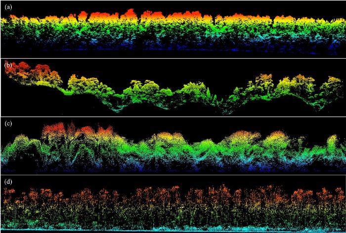
... 机载激光雷达的出现很大程度上促进了遥感在动物多样性领域研究的发展(Davies & Asner, 2014), 如飞行的脊椎动物(鸟类与蝙蝠) (Goetz et al, 2010, 2014)、非飞行的脊椎动物(食鱼貂与鹿) (Zhao et al, 2012)、无脊椎动物(甲虫与蜘蛛) (Müller & Brandl, 2009)以及其他类别动物的研究.机载激光雷达通过刻画精细的三维生境信息, 根据地面观测分析和提取动物的栖息地特征, 从而开展动物空间分布、种群密度和动物保护等研究(Clawges et al, 2008; Purkis et al, 2008).Goetz等(2010)利用激光雷达数据反演的冠层垂直结构信息分析了一种热带鸟类的分布特征并指出: 由激光雷达数据获得的森林结构数据是确定鸟类多样性的关键参数.由此建立了鸟类丰富度与森林结构的关系模型, 成功预测了该种鸟类在北美的分布情况(Goetz et al, 2014).Zhao等(2012)利用电子项圈监测食鱼貂的活动信息, 同时结合机载激光雷达获取的森林垂直结构信息, 揭示了食鱼貂对生境的喜好.Tempel等(2015)利用机载激光雷达获取的覆盖度和大树密度分析出加州斑点猫头鹰(Strix occidentalis)的筑巢特性, 并结合林火发生前后的森林结构差异推断出林火发生对猫头鹰产生的影响.Vihervaara 等(2015)结合地面调查的鸟类栖息情况与机载激光雷达数据获得的森林植被结构信息开展了景观尺度上的生物多样性评估, 并证实机载激光雷达数据提取的大量结构参数可用于量化生物多样性核心指标EBV.总而言之, 机载激光雷达获取的大范围森林垂直结构信息能够很好地用于动物多样性研究.如何从众多参数中提出共性的指标用于动物多样性监测, 则是下一步研究的关键. ...
Implications of land use transitions on soil nitrogen in dynamic landscapes in Tanzania
1
2017
... Biodiversity indicators that can be derived from satellite remote sensing
生物多样性核心指标 Essential biodiversity variables
卫星遥感能获取的指标 Indicators obtained from satellite remote sensing
物种数量 Species populations
物种分布 Species distribution (Saveraid et al, 2001; Leyequien et al, 2007; Shirley et al, 2013; Sequeira et al, 2014)
物种性状 Species traits
叶面积指数 LAI (Fuentes et al, 2008)、氮素含量 Nitrogen content (Ojoyi et al, 2017)等
群落组成 Community composition
物种密度 Species density (Hernández-Stefanoni & Dupuy, 2007; Godinho et al, 2016)、物种丰富度 Species richness (Knudby et al, 2010; Lucas et al, 2010)等
生态系统功能 Ecosystem function
植被绿度 Greenness (Zhou et al, 2014)、植被物候 Phenology (Ganguly et al, 2010)、光合作用能力和生态系统生产力 Photosynthesis and ecosystem productivity (Franklin et al, 2006; Mishra & Chaudhuri, 2015)等
生态系统结构 Ecosystem structure
景观破碎化和异质性 Landscape fragmentation and heterogeneity (Saatchi et al, 2001; Wang & Moskovits, 2001; Tuanmu & Jetz, 2015)、土地覆盖和土地利用 Landcover and land use (Farashi et al, 2016; Zhao et al, 2016)、植被高度 Vegetation height (Su et al, 2017)等
Examining fragmentation and loss of primary forest in the southern Bahian Atlantic forest of Brazil with radar imagery
1
2001
... Biodiversity indicators that can be derived from satellite remote sensing
生物多样性核心指标 Essential biodiversity variables
卫星遥感能获取的指标 Indicators obtained from satellite remote sensing
物种数量 Species populations
物种分布 Species distribution (Saveraid et al, 2001; Leyequien et al, 2007; Shirley et al, 2013; Sequeira et al, 2014)
物种性状 Species traits
叶面积指数 LAI (Fuentes et al, 2008)、氮素含量 Nitrogen content (Ojoyi et al, 2017)等
群落组成 Community composition
物种密度 Species density (Hernández-Stefanoni & Dupuy, 2007; Godinho et al, 2016)、物种丰富度 Species richness (Knudby et al, 2010; Lucas et al, 2010)等
生态系统功能 Ecosystem function
植被绿度 Greenness (Zhou et al, 2014)、植被物候 Phenology (Ganguly et al, 2010)、光合作用能力和生态系统生产力 Photosynthesis and ecosystem productivity (Franklin et al, 2006; Mishra & Chaudhuri, 2015)等
生态系统结构 Ecosystem structure
景观破碎化和异质性 Landscape fragmentation and heterogeneity (Saatchi et al, 2001; Wang & Moskovits, 2001; Tuanmu & Jetz, 2015)、土地覆盖和土地利用 Landcover and land use (Farashi et al, 2016; Zhao et al, 2016)、植被高度 Vegetation height (Su et al, 2017)等
Modeling distribution of Amazonian tree species and diversity using remote sensing measurements
3
2008
... 历经几十年的发展, 遥感卫星已形成成熟的观测体系.现有卫星在观测和记录电磁信号方面各有不同, 其能够获取的目标信息也有所不同(表1).遥感卫星分辨率从公里级逐渐迈入米级时代, 如IKONOS, OrbView及RapidEye等卫星.2000年后, 大量的商用陆地资源遥感卫星进入亚米级时代, 如QuickBird等.随着卫星时空光谱分辨率的不断提升, 大量学者利用卫星遥感技术获取与生物多样性相关的信息, 开展生物多样性保护评估和监测的研究(Gould, 2000; Kerr et al, 2001; Rocchini et al, 2007; Saatchi et al, 2008; Paganini et al, 2016). ...
... 目前, 卫星遥感数据主要用于植物和动物多样性研究工作中, 其中在植物多样性研究方面, 以卫星遥感为数据基础的研究主要关注物种组成、生态系统结构和功能三个方面(Martin et al, 1998; Carleer & Wolff, 2004).在研究物种组成方面, Saatchi等(2008)利用多源遥感数据, 结合与植被和气候相关的环境变量信息, 利用最大熵模型预测了亚马逊流域5种树的分布和多样性特征; Wilson等(2012)利用森林清查数据和中分辨率的遥感影像数据(Moderate Resolution Imaging Spectroradiometer, MODIS)研究了大尺度树种组成和分布.然而, 利用卫星遥感开展物种组成研究存在很大的局限性, 很多研究是建立在海量样本的基础上, 例如Wilson等(2012)的研究使用的是美国森林清查数据, 而且遥感数据只是提供了物候的信息.Saatchi等(2008)的研究则是分析部分树种的潜在分布, 与真实的物种分布和组成存在很大差异.在生态系统结构多样性方面, 利用光学影像获取光谱指数反演物种性状是最常用的手段之一(Clerici et al, 2012; Duffy & Pettorelli, 2012), 但受光学遥感的饱和效应影响, 其精度都很低.近年来, 激光雷达、合成孔径雷达技术等主动遥感技术的发展, 为精确测量森林三维结构(如树高、叶面积指数等)、预测生物量等提供了全新的手段(Hu et al, 2016; Su et al, 2016a, 2017).在生态系统功能方面, 主要是利用时间序列的遥感影像监测植被动态变化及其对气候变化的响应等(Jordan et al, 2012; Hutchinson et al, 2015; Lausch et al, 2016).利用卫星研究植被动态通常关注植被类型的变化, 即生态系统多样性, 对于物种尺度的变化研究较少. ...
... 的研究使用的是美国森林清查数据, 而且遥感数据只是提供了物候的信息.Saatchi等(2008)的研究则是分析部分树种的潜在分布, 与真实的物种分布和组成存在很大差异.在生态系统结构多样性方面, 利用光学影像获取光谱指数反演物种性状是最常用的手段之一(Clerici et al, 2012; Duffy & Pettorelli, 2012), 但受光学遥感的饱和效应影响, 其精度都很低.近年来, 激光雷达、合成孔径雷达技术等主动遥感技术的发展, 为精确测量森林三维结构(如树高、叶面积指数等)、预测生物量等提供了全新的手段(Hu et al, 2016; Su et al, 2016a, 2017).在生态系统功能方面, 主要是利用时间序列的遥感影像监测植被动态变化及其对气候变化的响应等(Jordan et al, 2012; Hutchinson et al, 2015; Lausch et al, 2016).利用卫星研究植被动态通常关注植被类型的变化, 即生态系统多样性, 对于物种尺度的变化研究较少. ...
Object-based classification of land cover and tree species by integrating airborne LiDAR and high spatial resolution imagery data
1
2012
... 航空遥感兼顾了不同尺度水平的数据获取和分析能力, 尤其在景观-区域尺度有着不可比拟的优势, 并广泛应用于生态系统组成、结构和功能研究.在植物多样性研究领域, 主要集中在植被性状(Asner et al, 2017)、植被结构(Coops et al, 2016)、物种识别(Asner & Martin, 2008; Sasaki et al, 2012)以及物种多样性(Carlson et al, 2007; Simonson et al, 2012)等方面.如Carlson等(2007)分析了夏威夷17个森林站点的林冠维管束植物丰富度与高光谱反射率的关系, 并指出与生化组分相关的几个波段特征能够很好地指示物种多样性.Simonson等(2012)利用机载激光雷达获取的冠层结构信息(如植被高度)来衡量物种组成和生物多样性; Coops等(2016)利用机载激光雷达能够精确刻画森林三维结构的优势, 研究了物种分布与森林生境结构的关系, 并提出了高度、覆盖度和复杂度三个森林水平和垂直结构的指数用于表征森林生物多样性水平.航空遥感通常搭载多种传感器, 一次航飞即可获取多类型数据, 进行数据融合后可更好地提取生物多样性信息.Su等(2016b)在美国加州内华达山脉开展了基于机载激光雷达和影像的植被类型制图研究, 利用贝叶斯和K-均值的自动聚类算法的非监督分类方法, 最终发现融入激光雷达数据的分类效果相比于只有光学影像的分类方法更加精确, 能够识别的植被类型更多.Asner等(2017)利用机载激光雷达和高光谱数据获取森林冠层的性状特征, 结合地形气候等环境分析了森林功能多样性的变化.Zhao等(2018)在神农架利用机载激光雷达和高光谱数据, 通过对植物结构特征和生化组分特征聚类来估算生物多样性.目前, 航空遥感很难获取准确的物种信息来反映生物多样性, 而且很多研究反演的物种多样性只是性状特征的聚类, 无法与真实的物种对应而且容易出现饱和现象. ...
Fine-scale bird monitoring from light unmanned aircraft systems
1
2012
... 无人机平台用于开展动物多样性研究具有独特的优势, 尤其是大型动物的种群数量和动物保护方面.Vermeulen等(2013)用无人机对非洲西部的非洲象进行监测, 共监测到34头大象.Mulero-Pazmany等(2014)将无人机用作犀牛反偷猎的工具, 使其成为非洲生物多样性保护的利器.对于海洋动物无人机也能发挥重要作用.研究者分别用无人机对海豹(Krause et al, 2017)、海狮(Adame et al, 2017)、海龟(Schofield et al, 2017)、儒艮(Hodgson et al, 2013)等海洋哺乳动物进行了监测.除了直接监测动物的数据和分布, 无人机平台还能更细致地获取生境信息用于各种动物的栖息地研究, 如黑猩猩(Pongo abelii) (Szantoi et al, 2017)、鲨鱼(Carcharhinus melanopterus and Himantura fai) (Kiszka et al, 2016)、鳄鱼(Crocodylus porosus)(Evans et al, 2015)等.Sarda-Palomera等(2012)在无人机鸟类监测研究中也已取得了明显的进展.此外还有人专门研究了无人机监测对野生动物的干扰(Brisson-Curadeau et al, 2017; Mulero-Pazmany et al, 2017). ...
A comparison of satellite data and landscape variables in predicting bird species occurrences in the Greater Yellowstone Ecosystem, USA
1
2001
... Biodiversity indicators that can be derived from satellite remote sensing
生物多样性核心指标 Essential biodiversity variables
卫星遥感能获取的指标 Indicators obtained from satellite remote sensing
物种数量 Species populations
物种分布 Species distribution (Saveraid et al, 2001; Leyequien et al, 2007; Shirley et al, 2013; Sequeira et al, 2014)
物种性状 Species traits
叶面积指数 LAI (Fuentes et al, 2008)、氮素含量 Nitrogen content (Ojoyi et al, 2017)等
群落组成 Community composition
物种密度 Species density (Hernández-Stefanoni & Dupuy, 2007; Godinho et al, 2016)、物种丰富度 Species richness (Knudby et al, 2010; Lucas et al, 2010)等
生态系统功能 Ecosystem function
植被绿度 Greenness (Zhou et al, 2014)、植被物候 Phenology (Ganguly et al, 2010)、光合作用能力和生态系统生产力 Photosynthesis and ecosystem productivity (Franklin et al, 2006; Mishra & Chaudhuri, 2015)等
生态系统结构 Ecosystem structure
景观破碎化和异质性 Landscape fragmentation and heterogeneity (Saatchi et al, 2001; Wang & Moskovits, 2001; Tuanmu & Jetz, 2015)、土地覆盖和土地利用 Landcover and land use (Farashi et al, 2016; Zhao et al, 2016)、植被高度 Vegetation height (Su et al, 2017)等
Detecting elusive aspects of wildlife ecology using drones: New insights on the mating dynamics and operational sex ratios of sea turtles
1
2017
... 无人机平台用于开展动物多样性研究具有独特的优势, 尤其是大型动物的种群数量和动物保护方面.Vermeulen等(2013)用无人机对非洲西部的非洲象进行监测, 共监测到34头大象.Mulero-Pazmany等(2014)将无人机用作犀牛反偷猎的工具, 使其成为非洲生物多样性保护的利器.对于海洋动物无人机也能发挥重要作用.研究者分别用无人机对海豹(Krause et al, 2017)、海狮(Adame et al, 2017)、海龟(Schofield et al, 2017)、儒艮(Hodgson et al, 2013)等海洋哺乳动物进行了监测.除了直接监测动物的数据和分布, 无人机平台还能更细致地获取生境信息用于各种动物的栖息地研究, 如黑猩猩(Pongo abelii) (Szantoi et al, 2017)、鲨鱼(Carcharhinus melanopterus and Himantura fai) (Kiszka et al, 2016)、鳄鱼(Crocodylus porosus)(Evans et al, 2015)等.Sarda-Palomera等(2012)在无人机鸟类监测研究中也已取得了明显的进展.此外还有人专门研究了无人机监测对野生动物的干扰(Brisson-Curadeau et al, 2017; Mulero-Pazmany et al, 2017). ...
Predicting current and future global distributions of whale sharks
1
2014
... Biodiversity indicators that can be derived from satellite remote sensing
生物多样性核心指标 Essential biodiversity variables
卫星遥感能获取的指标 Indicators obtained from satellite remote sensing
物种数量 Species populations
物种分布 Species distribution (Saveraid et al, 2001; Leyequien et al, 2007; Shirley et al, 2013; Sequeira et al, 2014)
物种性状 Species traits
叶面积指数 LAI (Fuentes et al, 2008)、氮素含量 Nitrogen content (Ojoyi et al, 2017)等
群落组成 Community composition
物种密度 Species density (Hernández-Stefanoni & Dupuy, 2007; Godinho et al, 2016)、物种丰富度 Species richness (Knudby et al, 2010; Lucas et al, 2010)等
生态系统功能 Ecosystem function
植被绿度 Greenness (Zhou et al, 2014)、植被物候 Phenology (Ganguly et al, 2010)、光合作用能力和生态系统生产力 Photosynthesis and ecosystem productivity (Franklin et al, 2006; Mishra & Chaudhuri, 2015)等
生态系统结构 Ecosystem structure
景观破碎化和异质性 Landscape fragmentation and heterogeneity (Saatchi et al, 2001; Wang & Moskovits, 2001; Tuanmu & Jetz, 2015)、土地覆盖和土地利用 Landcover and land use (Farashi et al, 2016; Zhao et al, 2016)、植被高度 Vegetation height (Su et al, 2017)等
Species distribution modelling for the people: Unclassified landsat TM imagery predicts bird occurrence at fine resolutions
1
2013
... Biodiversity indicators that can be derived from satellite remote sensing
生物多样性核心指标 Essential biodiversity variables
卫星遥感能获取的指标 Indicators obtained from satellite remote sensing
物种数量 Species populations
物种分布 Species distribution (Saveraid et al, 2001; Leyequien et al, 2007; Shirley et al, 2013; Sequeira et al, 2014)
物种性状 Species traits
叶面积指数 LAI (Fuentes et al, 2008)、氮素含量 Nitrogen content (Ojoyi et al, 2017)等
群落组成 Community composition
物种密度 Species density (Hernández-Stefanoni & Dupuy, 2007; Godinho et al, 2016)、物种丰富度 Species richness (Knudby et al, 2010; Lucas et al, 2010)等
生态系统功能 Ecosystem function
植被绿度 Greenness (Zhou et al, 2014)、植被物候 Phenology (Ganguly et al, 2010)、光合作用能力和生态系统生产力 Photosynthesis and ecosystem productivity (Franklin et al, 2006; Mishra & Chaudhuri, 2015)等
生态系统结构 Ecosystem structure
景观破碎化和异质性 Landscape fragmentation and heterogeneity (Saatchi et al, 2001; Wang & Moskovits, 2001; Tuanmu & Jetz, 2015)、土地覆盖和土地利用 Landcover and land use (Farashi et al, 2016; Zhao et al, 2016)、植被高度 Vegetation height (Su et al, 2017)等
Spatial distribution of forest aboveground biomass in China: Estimation through combination of spaceborne Lidar, optical imagery, and forest inventory data
1
2016
... 目前, 卫星遥感数据主要用于植物和动物多样性研究工作中, 其中在植物多样性研究方面, 以卫星遥感为数据基础的研究主要关注物种组成、生态系统结构和功能三个方面(Martin et al, 1998; Carleer & Wolff, 2004).在研究物种组成方面, Saatchi等(2008)利用多源遥感数据, 结合与植被和气候相关的环境变量信息, 利用最大熵模型预测了亚马逊流域5种树的分布和多样性特征; Wilson等(2012)利用森林清查数据和中分辨率的遥感影像数据(Moderate Resolution Imaging Spectroradiometer, MODIS)研究了大尺度树种组成和分布.然而, 利用卫星遥感开展物种组成研究存在很大的局限性, 很多研究是建立在海量样本的基础上, 例如Wilson等(2012)的研究使用的是美国森林清查数据, 而且遥感数据只是提供了物候的信息.Saatchi等(2008)的研究则是分析部分树种的潜在分布, 与真实的物种分布和组成存在很大差异.在生态系统结构多样性方面, 利用光学影像获取光谱指数反演物种性状是最常用的手段之一(Clerici et al, 2012; Duffy & Pettorelli, 2012), 但受光学遥感的饱和效应影响, 其精度都很低.近年来, 激光雷达、合成孔径雷达技术等主动遥感技术的发展, 为精确测量森林三维结构(如树高、叶面积指数等)、预测生物量等提供了全新的手段(Hu et al, 2016; Su et al, 2016a, 2017).在生态系统功能方面, 主要是利用时间序列的遥感影像监测植被动态变化及其对气候变化的响应等(Jordan et al, 2012; Hutchinson et al, 2015; Lausch et al, 2016).利用卫星研究植被动态通常关注植被类型的变化, 即生态系统多样性, 对于物种尺度的变化研究较少. ...
A vegetation mapping strategy for conifer forests by combining airborne LiDAR data and aerial imagery
1
2016
... 航空遥感兼顾了不同尺度水平的数据获取和分析能力, 尤其在景观-区域尺度有着不可比拟的优势, 并广泛应用于生态系统组成、结构和功能研究.在植物多样性研究领域, 主要集中在植被性状(Asner et al, 2017)、植被结构(Coops et al, 2016)、物种识别(Asner & Martin, 2008; Sasaki et al, 2012)以及物种多样性(Carlson et al, 2007; Simonson et al, 2012)等方面.如Carlson等(2007)分析了夏威夷17个森林站点的林冠维管束植物丰富度与高光谱反射率的关系, 并指出与生化组分相关的几个波段特征能够很好地指示物种多样性.Simonson等(2012)利用机载激光雷达获取的冠层结构信息(如植被高度)来衡量物种组成和生物多样性; Coops等(2016)利用机载激光雷达能够精确刻画森林三维结构的优势, 研究了物种分布与森林生境结构的关系, 并提出了高度、覆盖度和复杂度三个森林水平和垂直结构的指数用于表征森林生物多样性水平.航空遥感通常搭载多种传感器, 一次航飞即可获取多类型数据, 进行数据融合后可更好地提取生物多样性信息.Su等(2016b)在美国加州内华达山脉开展了基于机载激光雷达和影像的植被类型制图研究, 利用贝叶斯和K-均值的自动聚类算法的非监督分类方法, 最终发现融入激光雷达数据的分类效果相比于只有光学影像的分类方法更加精确, 能够识别的植被类型更多.Asner等(2017)利用机载激光雷达和高光谱数据获取森林冠层的性状特征, 结合地形气候等环境分析了森林功能多样性的变化.Zhao等(2018)在神农架利用机载激光雷达和高光谱数据, 通过对植物结构特征和生化组分特征聚类来估算生物多样性.目前, 航空遥感很难获取准确的物种信息来反映生物多样性, 而且很多研究反演的物种多样性只是性状特征的聚类, 无法与真实的物种对应而且容易出现饱和现象. ...
Fine-resolution forest tree height estimation across the Sierra Nevada through the integration of spaceborne LiDAR, airborne LiDAR, and optical imagery
2
2017
... 目前, 卫星遥感数据主要用于植物和动物多样性研究工作中, 其中在植物多样性研究方面, 以卫星遥感为数据基础的研究主要关注物种组成、生态系统结构和功能三个方面(Martin et al, 1998; Carleer & Wolff, 2004).在研究物种组成方面, Saatchi等(2008)利用多源遥感数据, 结合与植被和气候相关的环境变量信息, 利用最大熵模型预测了亚马逊流域5种树的分布和多样性特征; Wilson等(2012)利用森林清查数据和中分辨率的遥感影像数据(Moderate Resolution Imaging Spectroradiometer, MODIS)研究了大尺度树种组成和分布.然而, 利用卫星遥感开展物种组成研究存在很大的局限性, 很多研究是建立在海量样本的基础上, 例如Wilson等(2012)的研究使用的是美国森林清查数据, 而且遥感数据只是提供了物候的信息.Saatchi等(2008)的研究则是分析部分树种的潜在分布, 与真实的物种分布和组成存在很大差异.在生态系统结构多样性方面, 利用光学影像获取光谱指数反演物种性状是最常用的手段之一(Clerici et al, 2012; Duffy & Pettorelli, 2012), 但受光学遥感的饱和效应影响, 其精度都很低.近年来, 激光雷达、合成孔径雷达技术等主动遥感技术的发展, 为精确测量森林三维结构(如树高、叶面积指数等)、预测生物量等提供了全新的手段(Hu et al, 2016; Su et al, 2016a, 2017).在生态系统功能方面, 主要是利用时间序列的遥感影像监测植被动态变化及其对气候变化的响应等(Jordan et al, 2012; Hutchinson et al, 2015; Lausch et al, 2016).利用卫星研究植被动态通常关注植被类型的变化, 即生态系统多样性, 对于物种尺度的变化研究较少. ...
... Biodiversity indicators that can be derived from satellite remote sensing
生物多样性核心指标 Essential biodiversity variables
卫星遥感能获取的指标 Indicators obtained from satellite remote sensing
物种数量 Species populations
物种分布 Species distribution (Saveraid et al, 2001; Leyequien et al, 2007; Shirley et al, 2013; Sequeira et al, 2014)
物种性状 Species traits
叶面积指数 LAI (Fuentes et al, 2008)、氮素含量 Nitrogen content (Ojoyi et al, 2017)等
群落组成 Community composition
物种密度 Species density (Hernández-Stefanoni & Dupuy, 2007; Godinho et al, 2016)、物种丰富度 Species richness (Knudby et al, 2010; Lucas et al, 2010)等
生态系统功能 Ecosystem function
植被绿度 Greenness (Zhou et al, 2014)、植被物候 Phenology (Ganguly et al, 2010)、光合作用能力和生态系统生产力 Photosynthesis and ecosystem productivity (Franklin et al, 2006; Mishra & Chaudhuri, 2015)等
生态系统结构 Ecosystem structure
景观破碎化和异质性 Landscape fragmentation and heterogeneity (Saatchi et al, 2001; Wang & Moskovits, 2001; Tuanmu & Jetz, 2015)、土地覆盖和土地利用 Landcover and land use (Farashi et al, 2016; Zhao et al, 2016)、植被高度 Vegetation height (Su et al, 2017)等
Mapping orangutan habitat and agricultural areas using Landsat OLI imagery augmented with unmanned aircraft system aerial photography
1
2017
... 无人机平台用于开展动物多样性研究具有独特的优势, 尤其是大型动物的种群数量和动物保护方面.Vermeulen等(2013)用无人机对非洲西部的非洲象进行监测, 共监测到34头大象.Mulero-Pazmany等(2014)将无人机用作犀牛反偷猎的工具, 使其成为非洲生物多样性保护的利器.对于海洋动物无人机也能发挥重要作用.研究者分别用无人机对海豹(Krause et al, 2017)、海狮(Adame et al, 2017)、海龟(Schofield et al, 2017)、儒艮(Hodgson et al, 2013)等海洋哺乳动物进行了监测.除了直接监测动物的数据和分布, 无人机平台还能更细致地获取生境信息用于各种动物的栖息地研究, 如黑猩猩(Pongo abelii) (Szantoi et al, 2017)、鲨鱼(Carcharhinus melanopterus and Himantura fai) (Kiszka et al, 2016)、鳄鱼(Crocodylus porosus)(Evans et al, 2015)等.Sarda-Palomera等(2012)在无人机鸟类监测研究中也已取得了明显的进展.此外还有人专门研究了无人机监测对野生动物的干扰(Brisson-Curadeau et al, 2017; Mulero-Pazmany et al, 2017). ...
Evaluating short- and long-term impacts of fuels treatments and simulated wildfire on an old-forest species
1
2015
... 机载激光雷达的出现很大程度上促进了遥感在动物多样性领域研究的发展(Davies & Asner, 2014), 如飞行的脊椎动物(鸟类与蝙蝠) (Goetz et al, 2010, 2014)、非飞行的脊椎动物(食鱼貂与鹿) (Zhao et al, 2012)、无脊椎动物(甲虫与蜘蛛) (Müller & Brandl, 2009)以及其他类别动物的研究.机载激光雷达通过刻画精细的三维生境信息, 根据地面观测分析和提取动物的栖息地特征, 从而开展动物空间分布、种群密度和动物保护等研究(Clawges et al, 2008; Purkis et al, 2008).Goetz等(2010)利用激光雷达数据反演的冠层垂直结构信息分析了一种热带鸟类的分布特征并指出: 由激光雷达数据获得的森林结构数据是确定鸟类多样性的关键参数.由此建立了鸟类丰富度与森林结构的关系模型, 成功预测了该种鸟类在北美的分布情况(Goetz et al, 2014).Zhao等(2012)利用电子项圈监测食鱼貂的活动信息, 同时结合机载激光雷达获取的森林垂直结构信息, 揭示了食鱼貂对生境的喜好.Tempel等(2015)利用机载激光雷达获取的覆盖度和大树密度分析出加州斑点猫头鹰(Strix occidentalis)的筑巢特性, 并结合林火发生前后的森林结构差异推断出林火发生对猫头鹰产生的影响.Vihervaara 等(2015)结合地面调查的鸟类栖息情况与机载激光雷达数据获得的森林植被结构信息开展了景观尺度上的生物多样性评估, 并证实机载激光雷达数据提取的大量结构参数可用于量化生物多样性核心指标EBV.总而言之, 机载激光雷达获取的大范围森林垂直结构信息能够很好地用于动物多样性研究.如何从众多参数中提出共性的指标用于动物多样性监测, 则是下一步研究的关键. ...
A global, remote sensing-based characterization of terrestrial habitat heterogeneity for biodiversity and ecosystem modelling
1
2015
... Biodiversity indicators that can be derived from satellite remote sensing
生物多样性核心指标 Essential biodiversity variables
卫星遥感能获取的指标 Indicators obtained from satellite remote sensing
物种数量 Species populations
物种分布 Species distribution (Saveraid et al, 2001; Leyequien et al, 2007; Shirley et al, 2013; Sequeira et al, 2014)
物种性状 Species traits
叶面积指数 LAI (Fuentes et al, 2008)、氮素含量 Nitrogen content (Ojoyi et al, 2017)等
群落组成 Community composition
物种密度 Species density (Hernández-Stefanoni & Dupuy, 2007; Godinho et al, 2016)、物种丰富度 Species richness (Knudby et al, 2010; Lucas et al, 2010)等
生态系统功能 Ecosystem function
植被绿度 Greenness (Zhou et al, 2014)、植被物候 Phenology (Ganguly et al, 2010)、光合作用能力和生态系统生产力 Photosynthesis and ecosystem productivity (Franklin et al, 2006; Mishra & Chaudhuri, 2015)等
生态系统结构 Ecosystem structure
景观破碎化和异质性 Landscape fragmentation and heterogeneity (Saatchi et al, 2001; Wang & Moskovits, 2001; Tuanmu & Jetz, 2015)、土地覆盖和土地利用 Landcover and land use (Farashi et al, 2016; Zhao et al, 2016)、植被高度 Vegetation height (Su et al, 2017)等
... 自从美国宇航局共享Landsat系列卫星数据以来, 卫星遥感为生态学领域的各类研究提供了观测、分析和预测的数据(Turner et al, 2003; Pettorelli et al, 2014).相比于地面观测, 卫星遥感具有以下几点优势: (1)观测范围大, 能够直接获取全球尺度的数据; (2)能够实现长时间序列的观测和记录; (3)数据类型多样, 数据获取成本低.这些优势有利于生态学家获取物种组成、生态系统结构和功能相关信息, 尤其是长期积累的多源遥感数据为大尺度和长时间序列的生物多样性监测提供了可能(Kerr & Ostrovsky, 2003; Gillespie et al, 2008; Paganini et al, 2016). ...
... *指标参考以下文献: Turner et al, 2003; Duro et al, 2007; Dassot et al, 2011; Goetz et al, 2014 ...
Unmanned aerial survey of elephants
1
2013
... 无人机平台用于开展动物多样性研究具有独特的优势, 尤其是大型动物的种群数量和动物保护方面.Vermeulen等(2013)用无人机对非洲西部的非洲象进行监测, 共监测到34头大象.Mulero-Pazmany等(2014)将无人机用作犀牛反偷猎的工具, 使其成为非洲生物多样性保护的利器.对于海洋动物无人机也能发挥重要作用.研究者分别用无人机对海豹(Krause et al, 2017)、海狮(Adame et al, 2017)、海龟(Schofield et al, 2017)、儒艮(Hodgson et al, 2013)等海洋哺乳动物进行了监测.除了直接监测动物的数据和分布, 无人机平台还能更细致地获取生境信息用于各种动物的栖息地研究, 如黑猩猩(Pongo abelii) (Szantoi et al, 2017)、鲨鱼(Carcharhinus melanopterus and Himantura fai) (Kiszka et al, 2016)、鳄鱼(Crocodylus porosus)(Evans et al, 2015)等.Sarda-Palomera等(2012)在无人机鸟类监测研究中也已取得了明显的进展.此外还有人专门研究了无人机监测对野生动物的干扰(Brisson-Curadeau et al, 2017; Mulero-Pazmany et al, 2017). ...
How to integrate remotely sensed data and biodiversity for ecosystem assessments at landscape scale
1
2015
... 机载激光雷达的出现很大程度上促进了遥感在动物多样性领域研究的发展(Davies & Asner, 2014), 如飞行的脊椎动物(鸟类与蝙蝠) (Goetz et al, 2010, 2014)、非飞行的脊椎动物(食鱼貂与鹿) (Zhao et al, 2012)、无脊椎动物(甲虫与蜘蛛) (Müller & Brandl, 2009)以及其他类别动物的研究.机载激光雷达通过刻画精细的三维生境信息, 根据地面观测分析和提取动物的栖息地特征, 从而开展动物空间分布、种群密度和动物保护等研究(Clawges et al, 2008; Purkis et al, 2008).Goetz等(2010)利用激光雷达数据反演的冠层垂直结构信息分析了一种热带鸟类的分布特征并指出: 由激光雷达数据获得的森林结构数据是确定鸟类多样性的关键参数.由此建立了鸟类丰富度与森林结构的关系模型, 成功预测了该种鸟类在北美的分布情况(Goetz et al, 2014).Zhao等(2012)利用电子项圈监测食鱼貂的活动信息, 同时结合机载激光雷达获取的森林垂直结构信息, 揭示了食鱼貂对生境的喜好.Tempel等(2015)利用机载激光雷达获取的覆盖度和大树密度分析出加州斑点猫头鹰(Strix occidentalis)的筑巢特性, 并结合林火发生前后的森林结构差异推断出林火发生对猫头鹰产生的影响.Vihervaara 等(2015)结合地面调查的鸟类栖息情况与机载激光雷达数据获得的森林植被结构信息开展了景观尺度上的生物多样性评估, 并证实机载激光雷达数据提取的大量结构参数可用于量化生物多样性核心指标EBV.总而言之, 机载激光雷达获取的大范围森林垂直结构信息能够很好地用于动物多样性研究.如何从众多参数中提出共性的指标用于动物多样性监测, 则是下一步研究的关键. ...
Tracking fragmentation of natural communities and changes in land cover: Applications of Landsat data for conservation in an urban landscape (Chicago Wilderness)
1
2001
... Biodiversity indicators that can be derived from satellite remote sensing
生物多样性核心指标 Essential biodiversity variables
卫星遥感能获取的指标 Indicators obtained from satellite remote sensing
物种数量 Species populations
物种分布 Species distribution (Saveraid et al, 2001; Leyequien et al, 2007; Shirley et al, 2013; Sequeira et al, 2014)
物种性状 Species traits
叶面积指数 LAI (Fuentes et al, 2008)、氮素含量 Nitrogen content (Ojoyi et al, 2017)等
群落组成 Community composition
物种密度 Species density (Hernández-Stefanoni & Dupuy, 2007; Godinho et al, 2016)、物种丰富度 Species richness (Knudby et al, 2010; Lucas et al, 2010)等
生态系统功能 Ecosystem function
植被绿度 Greenness (Zhou et al, 2014)、植被物候 Phenology (Ganguly et al, 2010)、光合作用能力和生态系统生产力 Photosynthesis and ecosystem productivity (Franklin et al, 2006; Mishra & Chaudhuri, 2015)等
生态系统结构 Ecosystem structure
景观破碎化和异质性 Landscape fragmentation and heterogeneity (Saatchi et al, 2001; Wang & Moskovits, 2001; Tuanmu & Jetz, 2015)、土地覆盖和土地利用 Landcover and land use (Farashi et al, 2016; Zhao et al, 2016)、植被高度 Vegetation height (Su et al, 2017)等
Detailed dynamic land cover mapping of Chile: Accuracy improvement by integrating multi-temporal data
1
2016
... Biodiversity indicators that can be derived from satellite remote sensing
生物多样性核心指标 Essential biodiversity variables
卫星遥感能获取的指标 Indicators obtained from satellite remote sensing
物种数量 Species populations
物种分布 Species distribution (Saveraid et al, 2001; Leyequien et al, 2007; Shirley et al, 2013; Sequeira et al, 2014)
物种性状 Species traits
叶面积指数 LAI (Fuentes et al, 2008)、氮素含量 Nitrogen content (Ojoyi et al, 2017)等
群落组成 Community composition
物种密度 Species density (Hernández-Stefanoni & Dupuy, 2007; Godinho et al, 2016)、物种丰富度 Species richness (Knudby et al, 2010; Lucas et al, 2010)等
生态系统功能 Ecosystem function
植被绿度 Greenness (Zhou et al, 2014)、植被物候 Phenology (Ganguly et al, 2010)、光合作用能力和生态系统生产力 Photosynthesis and ecosystem productivity (Franklin et al, 2006; Mishra & Chaudhuri, 2015)等
生态系统结构 Ecosystem structure
景观破碎化和异质性 Landscape fragmentation and heterogeneity (Saatchi et al, 2001; Wang & Moskovits, 2001; Tuanmu & Jetz, 2015)、土地覆盖和土地利用 Landcover and land use (Farashi et al, 2016; Zhao et al, 2016)、植被高度 Vegetation height (Su et al, 2017)等
Forest species diversity mapping using airborne LiDAR and hyperspectral data in a subtropical forest in China
1
2018
... 航空遥感兼顾了不同尺度水平的数据获取和分析能力, 尤其在景观-区域尺度有着不可比拟的优势, 并广泛应用于生态系统组成、结构和功能研究.在植物多样性研究领域, 主要集中在植被性状(Asner et al, 2017)、植被结构(Coops et al, 2016)、物种识别(Asner & Martin, 2008; Sasaki et al, 2012)以及物种多样性(Carlson et al, 2007; Simonson et al, 2012)等方面.如Carlson等(2007)分析了夏威夷17个森林站点的林冠维管束植物丰富度与高光谱反射率的关系, 并指出与生化组分相关的几个波段特征能够很好地指示物种多样性.Simonson等(2012)利用机载激光雷达获取的冠层结构信息(如植被高度)来衡量物种组成和生物多样性; Coops等(2016)利用机载激光雷达能够精确刻画森林三维结构的优势, 研究了物种分布与森林生境结构的关系, 并提出了高度、覆盖度和复杂度三个森林水平和垂直结构的指数用于表征森林生物多样性水平.航空遥感通常搭载多种传感器, 一次航飞即可获取多类型数据, 进行数据融合后可更好地提取生物多样性信息.Su等(2016b)在美国加州内华达山脉开展了基于机载激光雷达和影像的植被类型制图研究, 利用贝叶斯和K-均值的自动聚类算法的非监督分类方法, 最终发现融入激光雷达数据的分类效果相比于只有光学影像的分类方法更加精确, 能够识别的植被类型更多.Asner等(2017)利用机载激光雷达和高光谱数据获取森林冠层的性状特征, 结合地形气候等环境分析了森林功能多样性的变化.Zhao等(2018)在神农架利用机载激光雷达和高光谱数据, 通过对植物结构特征和生化组分特征聚类来估算生物多样性.目前, 航空遥感很难获取准确的物种信息来反映生物多样性, 而且很多研究反演的物种多样性只是性状特征的聚类, 无法与真实的物种对应而且容易出现饱和现象. ...
Widespread decline of Congo rainforest greenness in the past decade
1
2014
... Biodiversity indicators that can be derived from satellite remote sensing
生物多样性核心指标 Essential biodiversity variables
卫星遥感能获取的指标 Indicators obtained from satellite remote sensing
物种数量 Species populations
物种分布 Species distribution (Saveraid et al, 2001; Leyequien et al, 2007; Shirley et al, 2013; Sequeira et al, 2014)
物种性状 Species traits
叶面积指数 LAI (Fuentes et al, 2008)、氮素含量 Nitrogen content (Ojoyi et al, 2017)等
群落组成 Community composition
物种密度 Species density (Hernández-Stefanoni & Dupuy, 2007; Godinho et al, 2016)、物种丰富度 Species richness (Knudby et al, 2010; Lucas et al, 2010)等
生态系统功能 Ecosystem function
植被绿度 Greenness (Zhou et al, 2014)、植被物候 Phenology (Ganguly et al, 2010)、光合作用能力和生态系统生产力 Photosynthesis and ecosystem productivity (Franklin et al, 2006; Mishra & Chaudhuri, 2015)等
生态系统结构 Ecosystem structure
景观破碎化和异质性 Landscape fragmentation and heterogeneity (Saatchi et al, 2001; Wang & Moskovits, 2001; Tuanmu & Jetz, 2015)、土地覆盖和土地利用 Landcover and land use (Farashi et al, 2016; Zhao et al, 2016)、植被高度 Vegetation height (Su et al, 2017)等
 , 胡天宇
, 胡天宇

